
Buy It Now
$5.95 Shipping Condition: New Location: Las Vegas, United States Colton's Railroad and Military Map of the United States. Mexico, and the West Indies Size: 24" x 32" 61 cm x 81 cm) x Also Available in ... more18" x 24" from our eBay Store This is a great Classic Map originally Published circa 1862. This is a detailed general map of portions of North America. Framed in decorative borders. Showing drainage, international and state boundaries, cities and towns, forts. Railroads in operation, and proposed lines. Insets: Colton's map of the Americas, Africa and a portion of Europe showing the Atlantic and part of the Pacific oceans. New Orleans and delta of the Mississippi. Louisiana.Mobile harbor, Alabama. Key West and Tortugas. Florida reefs.Wilmington and vicinity, N. Carolina. Beaufort and vicinity. N. Carolina.Norfolk, fortress Monroe, James River, Richmond, Petersburg&c&c. Map of Charleston. Port Royal& Savannah vicinities. Washington, Manassas Junction. Harpers Ferry, Baltimore, Annapolis This poster. Which evokes the vivid images of a simpler time, is a custom reproduction printed on 68lb Heavyweight Enhanced Matte Art Paper. This Historic Art Print is suitable for framing. Mounting or direct display on any wall! 000 Artscape Galleries/ Posters Past More Prints and Posters Available from our eBay Store! Shipping price includes delivery confirmation. We combine shipping for multiple purchases- add $1.00 for each additional poster. All posters are professionally packaged to ensure that they arrive safely and undamaged: Your poster is first rolled and inserted into a plastic sleeve before being placed into a Heavy-Duty mailing tube for delivery. We stand behind the quality of every poster. If you are not satisfied with your purchase. Please contact us within 30 days to arrange for either an exchange or a full refund. gsrx_vers_468(GS 6.4(468)
Buy It Now
$6.95 Shipping Location: Dover, United States Issued 1903, Chicago by George Cram. Early 20th century color lithographed map.
Buy It Now
$6.00 Shipping Location: Jacksonville, United States A beautiful and vibrantly colored map from the 1860 2nd edition Mitchell New General Atlas, the map was originally entered in to Congress in 1860.
Buy It Now
$44.99 Shipping Location: Ivanhoe, Australia (Par Le Snr. D Anville MDCCXLVI). (I have included an image of the map of the map when it is complete). D Anville, Jean Baptiste Bourguignon 1697-1782. ... moreDate: - 1756. The outnumbered French particularly depended on the Indians.
Buy It Now
Free Shipping Location: San Marcos, United States Sanson was official mapmaker to Louis XIV. Because of his royal position, Sanson had access to official French records of the explorations in the New ... moreWorld. ATLANTIS INSULA à NICOLAO SANSON Antiquitati Restituta; Nunc demum Majori Forma delineata, et in decem REGNA, Iuxta decem Neptuni Filios Distributa.
Buy It Now
$8.50 Shipping Location: Croatia When Pueblo tribes first encountered Spanish colonizers in the 16th century, the Zuni were living in Hawikuh and five or six other towns. In 1680 the ... moreZuni and other Pueblo tribes defeated the Spanish through the Pueblo Rebellion.
Buy It Now
Free Shipping Location: Reno, United States New York, 1832. This important, early Pocket Map of the United States is bound in its original, red leather boards. There is a table of population statistics ... morelower center. Overall this rare and important Map of the United States is well preserved and displays beautifully.
Buy It Now
$3.00 Shipping Location: Rockville, United States Up for sale is a great antique map of Mexico& Central America and the West Indies. Map was published in 1884 in Warren's Common-School Geography ... morepublished by Cowperthwait& Co. in Philadelphia. It measures approximately 10 x 12. On the other side is some miscellaneous wording about South America. Overall map is in good condition. Some browning around the edges. A few darker stains on the right side. But it does not affect the map. T here are holes up the left edge where it was originally bound. Will look very nice framed. Note also that while I have included a picture of the title page it is not included in the sale as it is a reference piece to determine authenticity for several other maps. I would be happy to include a copy if requested. Please see my store for other great items. Inventory R-4:`.RcmdId ViewItemDescV4,RlogId p4%60bo7%60jtb9%3Feog4d72f%2B%3E%3A%60%3E-145e5bcd68f-0x104-
Buy It Now
$6.95 Shipping Location: Dover, United States Issued 1875 Gotha by Justus Perthes for Stieler. Map by Stulpnagel. Very detailed 19th century engraved map with original outline hand color.
Buy It Now
Free Shipping Location: Sub Foreign S.O, India
Buy It Now
$3.50 Shipping Location: Dover, United States Year Published: 1948. Edition Year: 1948. The map in the photo is the actual map you will receive.
Buy It Now
$5.95 Shipping Location: Dover, United States Issued 1884 Gotha by Justus Perthes for Stieler. Very detailed 19th century engraved map with original outline hand color. Original center fold as issued. ... moreDictionary of Mapmakers, vol.
Buy It Now
$5.95 Shipping Condition: New Location: Las Vegas, United States Year: 1685. This is a great Classic Map originally Published circa 1685. “Vibrant and bright! Pic does not do it justice.looks amazing!”. Each of our ... moreprints are custom reproductions printed on 68lb Heavyweight Enhanced Matte Art Paper.
Buy It Now
$6.95 Shipping Location: Dover, United States Issued 1875 Gotha by Justus Perthes for Stieler. Very detailed 19th century engraved map with original outline hand color. Original center fold as issued.
Buy It Now
$6.95 Shipping Location: Dover, United States Issued 1852, Philadelphia by S. Augustus Mitchell. Map engraved by J.H. Young. Mid 19th century engraved map with original hand color.
Buy It Now
$22.78 Shipping Location: Dover, United States Mapping Trans-Mississippi West, 915. Mapping the West, pp. 158-9. Of note for recording the then still vast areas officially "unexplored". Light uniform ... morepaper age toning, original fold lines, slight paper creasing at lower left as seen, overall paper retains flexibility and integrity, remaining clean - a pleasing and well preserved visual example.
Buy It Now
$4.99 Shipping Location: Fairview, United States A facsimile copy of the title page is included for authenticity. This map is in its original uncolored state from a very scarce atlas of the period. Condition: ... moreThe map is in Very Good condition, uncolored as issued with text on the reverse.
Buy It Now
$6.95 Shipping Location: Dover, United States A detailed, scarce and interesting mid-19th century German map with original outline hand color.
Buy It Now
$11.85 Shipping Location: Dover, United States Map engraved by Rapkin. Vignettes drawn by J. Marchant & engraved by J. Rogers. Missouri Territory is massive and straddles a long oddly shaped narrow ... moreNebraska Territory. Lovely mid 19th century engraved decorative map with original outline hand color.
Buy It Now
Free Shipping Location: Pompano Beach, United States Glass is broken small little chip.
Buy It Now
$8.95 Shipping Location: Commerce, United States Pecos is on the west bank of the Pecos River and the county seat of Reeves County. The population is about 8,000. In the bowl of the spoon we read Pecos, ... moreTexas. The handle has the Texas star and detailed floral decoration with the back showing the state capitol and further decoration.
Buy It Now
$8.00 Shipping Location: Salt Lake City, United States Map produced as a promotional item for the book on the Dominguez and Escalante expedition 'Without Noise or Arms', where it is printed as the frontispiece. ... moreAuthor: Briggs, Walter and Wilson Hurley. 'A' condition.
Buy It Now
$10.00 Shipping Location: Chicago, United States He has long been suspected of wishing an excuse to fly. He has seen what they are blind to: the hopeless ness of resistance. On December 6th the Army ... moreof the West engaged in the bloody and ferocious battle of San Pasqual just outside San Diego.
Buy It Now
$10.05 Shipping Location: Belvedere Tiburon, United States This map was drawn by Friedrich Wilhelm Spehr and printed in Braunschweig at the Kunst und geographisches Bureau. It is dated 1827 and was intended to ... moreappear in Spehr’s Geographischer Universal-Atlas, a work that was begun in 1822 but never completed.
Buy It Now
$10.04 Shipping Condition: Unspecified Location: LONDON, United Kingdom Most of the plates used for this atlas were original engraved for the SDUK atlas in the mid nineteenth century. Antique colour atlas map, 1884. DATE PRINTED: ... more1884. CONDITION: Good; suitable for framing.

Buy It Now
$5.61 Shipping Location: Fairacres, United States Up for sale is the 1978 book Index of Mining Properties in Yuma County. Arizona by Stanton B. Keith. Geologist, produced by the State of Arizona Bureau ... moreof Geology. Description: The pages measure approximately 5" x 8" There are about 185 pages. And a small number of black& white maps. A description of mining districts and mines in the county. Condition: The book is in good condition with some tape marks to the cover and library markings inside the cover. The pages are otherwise clean. Please examine the photographs for further details. Thanks for looking! Shipping Information: All items will be packed safely and securely. And all orders come with delivery confirmation. Free shipping to anywhere in the U.S. and Puerto Rico. Calculated shipping to Canada. International buyers. Please contact me for details prior to bidding if interested in this item. Insurance available upon request. We strive for complete satisfaction of all customers and will take returns within 3 days; coins must not be removed from holders. Buyers. Please send payment within 48 hours. All items will be mailed within 1 day of payment(Monday-Friday)
Buy It Now
$7.99 Shipping Location: Lummi Island, United States Tres Zapotes is the third major city. This led to the first archaeological explorations in the area five years later. The city’s unique because it may ... morehave been inhabited for more than 2,000 consecutive years.
Buy It Now
$4.75 Shipping Location: Goshen, United States This information was previously automatically counted by an app I no longer use, which began around 2014. I thought you might enjoy seeing where buttons ... moreare sent. I may continue to manually tally these statistics, just for fun!
Buy It Now
$95.00 Shipping Location: North Chicago, United States Heavy Manganese and other mineral deposits remain on the surface, which is very characteristic of precolumbian artifacts. Priests may be part of a religious ... moreor political hierarch, while shamans depend on personal magnetism and successful performance.
Buy It Now
$6.95 Shipping Location: Dover, United States Issued 1869, Philadelphia by Butler. Map by Mitchell. Of note for the naming of Gold Regions in California as well as in Colorado and the Idaho/ Montana ... moreregion. There's gold everywhere you look, head west young man!
Buy It Now
$14.00 Shipping Location: Cleveland, United States Date of Publication Dated on title page 1825. (mislabled as No. [Caption title:] Pantographie de l'Histoire d'Amérique. Condition In overall very good ... moreto condition. Contemporary half calf over pastepaper boards, expertly rebacked with original spine backstrip laid down over new spine. ).
Buy It Now
$11.00 Shipping Location: Rockville, United States Up for sale is a great, original, hand colored, ANTIQUE MAP from THE COMMON-SCHOOL GEOGRAPHY - 1873. It is generally in Good- Condition. Creased corners. ... moreO ther dings here and there, as well.
Buy It Now
$6.53 Shipping Location: MARLOW, United Kingdom ARTIST/ENGRAVER: Engraved by J. Barlow. DATE PRINTED : 1807 (from a plate engraved in 1806, dated on the print). No sign of the Rocky Mountains. Louisiana ... moredominates the continent. The US Extends to the Mississippi, but pre-dates Tennessee, Kentucky and Ohio.
Buy It Now
$5.95 Shipping Condition: New Location: Las Vegas, United States This is a great Classic Map originally Published circa 1862. -- New Orleans and delta of the Mississippi, Louisiana. -- Key West and Tortugas, Florida ... morereefs. --Wilmington and vicinity, N. Carolina.
$7.52 Shipping Condition: Used Location: SALFORD, United Kingdom Britt, Russ (January 4, 2010). Archived from the original on October 31, 2020. Retrieved January 4, 2010. "AFI's 100 Years.100 Movie Quotes" (PDF). Archived ... morefrom the original (PDF) on July 16, 2011.
Buy It Now
Free Shipping Location: Tempe, United States This chart was compiled by F. H. Gerdes, the Coast Survey's resident Gulf expert. 16” x 21” Folded. Oversized along the top edge were removed from the ... moreoriginal publication. Light discoloration along the folds and one small separation in the center fold.

Buy It Now
$15.00 Shipping Location: Brooklyn, United States 1852 Meyer Map of the United States and Mexico WE SELL ONLY ORIGINAL ANTIQUE MAPS- NOT REPRODUCTIONS Title: Vereinigte Staaten von Nord-America und Mexico. ... moreDescription: This is a scarce 1852 map of the United States and Mexico by Joseph Meyer. Depicts the United States at the height of the California Gold Rush and shortly after the annexation of Texas. The map covers the United States from Coast to coast and shows a very early configuration of the Transmississippi. Nebraska is shown at its fullest. Extending from Kansas to the Canadian border. Montana, Wyoming, Idaho, Arizona, Colorado, West Virginia, and Nevada do not yet appear on the map. Shows the Mexico– U.S. Boundary line prior to the Gadsden Purchase. This map was issued at the height of the American westward expansion. Two years before this map was drawn the California gold discovery of 1849 enticed thousands to embark upon the rigorous transcontinental emigration. Meanwhile, with the rise in territorial population to the west of the Mississippi, the eastern states were becoming increasingly divided over the issues of slavery and state vs. federal sovereignty. Within a few years these disputes would lead to the American Civil War. This map was issued in Meyer's Zeitung Atlas. Although all the maps in this atlas are not individually dated, the title page and maps were often updated while the imprint with the date was not, causing confusion to the exact date for some of the maps. Moreover some maps in the atlas were taped in at a later date as an update to the atlas. We have dated the maps in this collection to the best of our ability. Size: Printed area measures 8 inches high by 11 inches wide. Condition: Very good. Minor toning and some foxing at places. Shipping: Shipping rates are not negotiable. Items are shipped within three business days of receiving payment. We are happy to consolidate shipping where possible. The following shipping options are available: 1. USPS Domestic Express Mail(35 USD) USA Only. 2. FedEx Ground or Home Delivery(15 USD)
Buy It Now
$30.00 Shipping Location: Paris VI, France In the bottom, a map of Caribbean with Cuba, Hispaniola, Jamaica and Bahamas. South Florida is represented with Keys islands. Edition: Antwerp, Christophe ... morePlantin, 1579, First Plantin Edition, 16th century.
Buy It Now
$6.95 Shipping Location: Dover, United States Map of the South Western District Louisiana. Surveyor General's Office. Donaldson, Oct. 29th, 1845. Early lithographed official topographical survey of ... morethis southern U.S. state.
Buy It Now
$6.95 Shipping Location: Dover, United States Mid 19th century color lithographed map. Note the vast territories still shown west of the Mississippi. Map by A. Skrzeszewski.
Buy It Now
$6.00 Shipping Location: Williamsport, United States A very nice pre-Revolutionary War magazine from the "mother country" with a wide range of varied content. This was the first periodical to use the word ... more"magazine" in its title, having begun in 1731 and lasting until 1907.
Buy It Now
$13.55 Shipping Location: Chicago, United States
Buy It Now
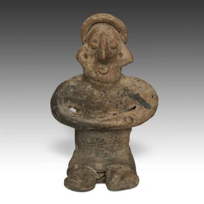
$400.00 Shipping Location: Merrick, United States The female is 9.75" (24.7 cm) tall, 7.75" (19.6 cm) wide and 6.25" (15.8 cm) front-to-back;. The male sits upright in an authoritative position with elbows ... moreout, hands on his knees, flexed legs. her nubile breasts exposed.

Buy It Now
$13.55 Shipping Location: Chicago, United States Normal 0 false false false EN-US X-NONE X-NONE GJPaw Auctions is pleased to offer a Pre-Columbian terracotta Standing Female Figure. From the Colima culture, ... moreWest Mexico. The area known archaeologically as West Mexico has long been recognized as a region of beautiful ceramic sculptures. Manifestations of a reverence for ancestors and a belief in the power of symbolism. These traits are recognized as characteristic of the cultural development of the region during the period from 300 B.C. to 400 A.D. the time of the Colima culture. Colima is best known for its finely finished red burnished effigies, both of humans and animals, especially dogs, and the solid small unburnished figurines, commonly called Colima flats. This beautifully modeled, solid archaic standing female figure is depicted wearing a headband, earrings and a necklace with multiple pendants. It measures 2 inches in width by 0.5 inches in depth by 6 inches in height(5.08 cm by 1.27 cm by 15.2 cm) The figure shows wear consistent with a Pre-Columbian dating, with a hairline cracks on both legs from previous repair work, but generally is in very good condition. It also comes with a specially designed, hand-made iron museum display stand for display. Guaranteed authentic, it would make a superb addition to any collection of Pre-Columbian ceramics. The famous mural artist Diego Rivera began his collection of Mexican pottery with small Colima figures- the collection later grew into a national treasure which was eventually housed in the Rivera Museum in Mexico City. GJPaw Auctions has been in the Art business for over 25 years and is now expanding its operation to eBay. Our goal is to bring the same experience and excitement of collecting that we have been delivering in-person to collectors across the globe at Primitive in Chicago. Every object we sell online has been carefully hand-selected with special attention to detail. Quality, and significance. We ship worldwide. Add GJPaw to Sellers you Follow and please take a moment to look at our other auctio
Buy It Now
$5.86 Shipping Location: Las Cruces, United States Publisher: USDA Forest Service. Print Date: 2016.
Buy It Now
$6.53 Shipping Location: MARLOW, United Kingdom ARTIST/ENGRAVER: Engraved by J. Barlow. PROVENANCE: This antique map was first published in 'A General View of The World, Geographical, Historical and ... morePhilosophical.' by the Rev. E. Blomfield. Published by C. Brightly and T. Kinnersley, Bungay Suffolk, 1807.
Buy It Now
$4.75 Shipping Location: Goshen, United States This information was previously automatically counted by an app I no longer use, which began around 2014. I thought you might enjoy seeing where buttons ... moreare sent. CANADA: Alberta – 8, British Columbia – 60, Manitoba – 2, Nova Scotia – 14, Ontario – 13, Ottawa – 1, Quebec – 9, Saskatchewan – 1, Winnipeg - 1.
Buy It Now
$11.60 Shipping Location: San Diego, United States
Buy It Now
$6.00 Shipping Location: Santa Barbara, United States Includes "explanation" and notes. Relief shown by hachures and spot heights on insets. Lithographed map, hand-colored in outline. Spectacular map of the ... moreUnited States, the main map covering the eastern states to beyond the Mississippi, with large portions of Texas, Nebraska, "part of the North-West Territory," etc.
Buy It Now
$10.04 Shipping Condition: Unspecified Location: LONDON, United Kingdom Most of the plates used for this atlas were original engraved for the SDUK atlas in the mid nineteenth century. Antique colour atlas map, 1889. DATE PRINTED: ... more1889. CONDITION: Good; suitable for framing.
Buy It Now
$13.51 Shipping Location: GIRVAN, United Kingdom Double-sided antique map. Side 2 WEST INDIA ISLANDS. Pub'd by W & A K Johnston. Size 12" x 9.5" (approx).
Buy It Now
$13.55 Shipping Location: Chicago, United States Normal 0 false false false EN-US X-NONE X-NONE GJPaw Auctions is pleased to offer a Pre-Columbian terracotta Standing Female Figure. From the Colima culture, ... moreWest Mexico. The area known archaeologically as West Mexico has long been recognized as a region of beautiful ceramic sculptures. Manifestations of a reverence for ancestors and a belief in the power of symbolism. These traits are recognized as characteristic of the cultural development of the region during the period from 300 B.C. to 400 A.D. the time of the Colima culture. Colima is best known for its finely finished red burnished effigies, both of humans and animals, especially dogs, and the solid small unburnished figurines, commonly called Colima flats. This beautifully modeled, solid archaic standing female figure is depicted wearing a headband, earrings and a necklace with multiple pendants. It measures 2 inches in width by 0.5 inches in depth by 6 inches in height(5.08 cm by 1.27 cm by 15.2 cm) The figure shows wear consistent with a Pre-Columbian dating, with a hairline cracks on both legs from previous repair work, but generally is in very good condition. It also comes with a specially designed, hand-made iron museum display stand for display. Guaranteed authentic, it would make a superb addition to any collection of Pre-Columbian ceramics. The famous mural artist Diego Rivera began his collection of Mexican pottery with small Colima figures- the collection later grew into a national treasure which was eventually housed in the Rivera Museum in Mexico City. GJPaw Auctions has been in the Art business for over 25 years and is now expanding its operation to eBay. Our goal is to bring the same experience and excitement of collecting that we have been delivering in-person to collectors across the globe at Primitive in Chicago. Every object we sell online has been carefully hand-selected with special attention to detail. Quality, and significance. We ship worldwide. Add GJPaw to Sellers you Follow and please take a moment to look at our other auctio
Buy It Now
Free Shipping Location: Merrick, United States Provenance : Sotheby Parke-Bernet Gallery in New York City, 11/07/1980, sale 4465Y, lot 295, illustrated in the catalog (penultimate image). STANDING ... moreCOUPLE.
Buy It Now
Free Shipping Location: Schertz, United States The map is not " new " or in " new " condition, it was printed in 1965. The map is not dated. Including Hundreds of RareCivil War.
Buy It Now
$35.99 Shipping Location: San Diego, United States The map depicts the region from the Pacific Ocean to the Atlantic Ocean and from Canada to Panama. Highly detailed, myriad cities and towns are labeled ... morethroughout the eastern United States, including state capitals and Washington, D.C. States are shaded different colors to allow for easy differentiation.

Buy It Now
$13.55 Shipping Location: Chicago, United States Normal 0 false false false EN-US X-NONE X-NONE GJPaw Auctions is pleased to offer a Pre-Columbian terracotta Standing Figure. From the Colima culture, ... moreWest Mexico. The area known archaeologically as West Mexico has long been recognized as a region of beautiful ceramic sculptures. Manifestations of a reverence for ancestors and a belief in the power of symbolism. These traits are recognized as characteristic of the cultural development of the region during the period from 300 B.C. to 400 A.D. the time of the Colima culture. Colima is best known for its finely finished red burnished effigies, both of humans and animals, especially dogs, and the solid small unburnished figurines, commonly called Colima flats. This unusual and beautifully modeled, solid archaic standing figure is depicted in a casual pose, while in the process of movement. It measures 2 inches in width by 0.5 inches in depth by 6 inches in height(5.08 cm by 1.27 cm by 15.2 cm) The figure shows wear consistent with a Pre-Columbian dating, including rubbing and tiny chips, but generally is in very good condition. It also comes with a specially designed, hand-made museum display stand for display. Guaranteed authentic, it would make a superb addition to any collection of Pre-Columbian ceramics. The famous mural artist Diego Rivera began his collection of Mexican pottery with small Colima figures- the collection later grew into a national treasure which was eventually housed in the Rivera Museum in Mexico City. GJPaw Auctions has been in the Art business for over 25 years and is now expanding its operation to eBay. Our goal is to bring the same experience and excitement of collecting that we have been delivering in-person to collectors across the globe at Primitive in Chicago. Every object we sell online has been carefully hand-selected with special attention to detail. Quality, and significance. We ship worldwide. Add GJPaw to Sellers you Follow and please take a moment to look at our other auction items. A010827-388
Buy It Now
$17.87 Shipping Location: Mount Cotton, Australia David Rumsey has 1829 similar as page XXIII, but there are many from Black's Atlas up to 1845 with a higher plate number. This is XXII and likely an early ... morepublication. The passage wasn't officially discovered for another 15 years or so.
Buy It Now
$8.95 Shipping Location: Branch, United States His mother, Constance Maynard, a well-educated daughter of a Navy officer from San Francisco, shared her love of classic literature with the young boy ... moreand encouraged him in his writing and drawing. Dixon is considered one of the finest artists having dedicated most of their art to the U.S. Southwestern cultures and landscapes at the end of the 19th-century and the first half of the 20th-century.
Buy It Now
$11.85 Shipping Location: Dover, United States Map engraved by Rapkin. Vignettes drawn by J. Marchant & engraved by J. Rogers. Missouri Territory is massive and straddles a long oddly shaped narrow ... moreNebraska Territory. Lovely mid 19th century engraved decorative map with original outline hand color.
Buy It Now
$6.95 Shipping Location: Dover, United States Issued 1876 Gotha by Justus Perthes for Stieler. Map by Stulpnagel. Engraved by Behrens. Very detailed 19th century engraved map with original outline ... morehand color. Original center fold as issued.
|