-
Christian Collectibles
-
Christian Sheet Music
-
Vatican Stamps
-
Vatican Coins & Paper Money
-
Antiques
-
Antiquities
-
Architectural & Garden
-
Decorative Arts
-
Ethnographic
-
Furniture
-
Maps, Atlases & Globes
-
United States (Pre-1900)
-
United States (1900-Now)
-
AK, HI
-
AL, FL, GA, MS, NC, SC
-
AR, IA, KS, LA, MO, NE
-
AZ, CA, CO, NM, NV, UT
-
CT, MA, ME, NH, RI, VT
-
DC, DE, MD, NJ, NY, PA
-
ID, OR, WA
-
IL, IN, MI, OH, WI
-
MN, MT, ND, SD, WY
-
OK, TX
-
VA, WV, KY, TN
-
Entire US
-
United States (Date Unknown)
-
Africa
-
Asia
-
Australasia/ Oceania
-
Canada
-
Central America/ Caribbean
-
Europe
-
India
-
Ireland
-
Mexico
-
Middle East
-
North America
-
South America
-
United Kingdom
-
Maps on CD
-
World Maps
-
Globes
-
Mixed Lots
-
Reproductions
-
Price Guides & Publications
-
Other
|
In
Order by: Available to: This site contains affiliate links for which I may be compensated
|
Buy It Now
$8.79 Shipping Location: Greenacres, United States Scarce first edition of Homann's highly decorative double-hemisphere map of the World, showing California as an island and richly embellished with Celestial ... moremodels of the northern and southern hemispheres.
Buy It Now
$4.59 Shipping Location: Greenacres, United States Huge, colorful fold-out 1958 Rand McNally wall-size map of the world. It is dated in the lower right corner. It folds to 10½" x 7½" and is blank on the ... moreback, with no printing on the reverse side.
Buy It Now
$4.69 Shipping Location: Greenacres, United States The map is titledCircuitus Orbis Terrarum Veteribus Cogniti (The world as known to the Ancients). The map was complied from various sources, including ... morePtolemy, Herodotus, Thucydides, and others.
Buy It Now
$4.69 Shipping Location: Greenacres, United States This map would make a very impressive display in your den or office.
Buy It Now
$5.95 Shipping Condition: New Location: Las Vegas, United States “Vibrant and bright! Pic does not do it justice.looks amazing!”. A very interesting double hemisphere map with polar projections by Oronce Finé. Each ... moreof our prints are custom reproductions printed on 68lb Heavyweight Enhanced Matte Art Paper.
Buy It Now
$5.95 Shipping Condition: New Location: Las Vegas, United States Year: 1565. Universale Descrittione di Tutta la Terra Conoscivta fin Qui. “Vibrant and bright! Pic does not do it justice.looks amazing!”. Each of our ... moreprints are custom reproductions printed on 68lb Heavyweight Enhanced Matte Art Paper.
Buy It Now
$6.65 Shipping Location: Roanoke, United States Old World Map Corners Framed Art 25”x32”. Shipped with USPS Ground Advantage.
Buy It Now
Free Shipping Location: Sheridan, United States Beautiful antique-style reproduction map. This would look great framed. Shows the full Turks and Caicos island chain. With a summary of their history ... more51cm x 46cm Posted with Posted with
Buy It Now
Free Shipping Condition: New Location: Orlando, United States This includes 2 copies of Gleason's New Standard Map Of The World - Large 24" x 36" from 1892. Its is large and detailed. This is the real deal.
Buy It Now
$3.95 Shipping Location: Clarkston, United States Alexander Gleason New Standard Map of the World - Flat Earth. Gleason's new standard map of the world on the projection of J. S. Christopher, Modern College, ... moreBlackheath, England; scientifically and practically correct ; as "it is.".
Buy It Now
$9.95 Shipping Condition: New Location: Clarkston, United States 1892 Alexander Gleason's New Standard Map of the World - Flat Earth. Gleason's new standard map of the world on the projection of J. S. Christopher, Modern ... moreCollege, Blackheath, England; scientifically and practically correct ; as "it is.".
Buy It Now
$3.95 Shipping Location: Clarkston, United States Alexander Gleason New Standard Map of the World - 1892 Flat Earth. Gleason's new standard map of the world on the projection of J. S. Christopher, Modern ... moreCollege, Blackheath, England; scientifically and practically correct ; as "it is.".
Buy It Now
$9.95 Shipping Condition: New Location: Clarkston, United States Alexander Gleason's Flat Earth Map of the World. Gleason's new standard map of the world on the projection of J. S. Christopher, Modern College, Blackheath, ... moreEngland; scientifically and practically correct ; as "it is.".
Buy It Now
$6.00 Shipping Location: Greenacres, United States It is dated 1887 in the lower margin. Original antique lithographed 1887 World map, printed more than 130 years ago.
Buy It Now
$6.00 Shipping Location: Greenacres, United States There is a large inset depicting the region around the South Pole, with notes on points reached by various explorers. This map would make a very impressive ... moredisplay in your den or office.
Buy It Now
$4.59 Shipping Location: Greenacres, United States The map opens to a generous 26" x 39" and it shows the world's political landscape as it existed a dozen years after the First World War, including areas ... morewhere boundaries were still in dispute: Manchuria, Bolivia, Ecuador, Paraguay, and Peru.
Buy It Now
Free Shipping Condition: New Location: Orlando, United States This includes 3 copies of Gleason's New Standard Map Of The World - Large 24" x 36" from 1892. Its is large and detailed. This is the real deal.
$3.95 Shipping Location: Clarkston, United States Alexander Gleason's New Standard Map of the World Flat Earth. Size: 23"x32". Gleason's new standard map of the world on the projection of J. S. Christopher, ... moreModern College, Blackheath, England; scientifically and practically correct ; as "it is.".
Buy It Now
$10.00 Shipping Location: Turkey Rare, large size, 107x90 cm.

Buy It Now
Free Shipping Location: Sheridan, United States Fine Caribbean Maps and Prints One Treasure Limited © offers unique and collectible maps. These"Old World Style" maps capture the past ... moreyet chart the exotic destinations of today. We have been in business for over 20 years. The collection is composed of over forty different maps taken from original watercolor paintings. They are meticulously printed on quality parchment paper. One Treasure Limited owns the originals of all our maps. So these prints are made specifically by us. Quintana Roo Map Quintana Roo is a state of Mexico. On the eastern part of the Yucatán Peninsula. It is the youngest state of the Mexican Republic. Its beaches. Considered among the most beautiful in the world, are surrounded by the deep blue to clear turquoise waters of the Caribbean Sea. With an abundant of natural landscapes Quintana Roo is a wonderful place for those who like hunting, fishing and aquatic sports. Size: 16 3/4"x 24" Please contact us before leaving negative feedback; give us a chance to resolve your problem. Once you leave positive feedback for us. We will leave positive feedback in return asap. On Mar-30-07 at 17:17:11 PDT. Seller added the following information: On Jun-09-11 at 09:48:42 PDT. Seller added the following information:
Buy It Now
$21.05 Shipping Condition: Brand New Location: Rosny Park, Australia Our Digital Prints are high quality reproductions individually printed on special large format printers. These beautiful digital reproductions are virtually ... moreunparalleled in quality and range of colour and are at the leading edge of fine art printmaking.
Buy It Now
$24.75 Shipping Condition: New Location: Gatlinburg, United States Wooden box and trunk. Size: 12.6' X 8.7' X 4.3' 32cm X 22cm X 11cm) Decorative trunk box that is great for storage and decoration. Old fashioned ... morehardware adds to antique look. All handmade. We care for our reputation. Posted with
Buy It Now
$5.95 Shipping Condition: New Location: Las Vegas, United States Year: 1689. This Beautiful detailed map of the world as it was known in 1689. Each of our prints are custom reproductions printed on 68lb Heavyweight ... moreEnhanced Matte Art Paper. These Historic Art Prints are suitable for framing, mounting or direct display on any wall!
Buy It Now
$5.95 Shipping Condition: New Location: Las Vegas, United States Year: 1630. Beautiful old map by Hendrik Hondius originally created in 1630. Each of our prints are custom reproductions printed on 68lb Heavyweight Enhanced ... moreMatte Art Paper. These Historic Art Prints are suitable for framing, mounting or direct display on any wall!
Free Shipping Location: Schertz, United States Explore the world of 1856 with this antique original atlas map. This 11x13 inches map showcases the East-West world hemispheres, mountains, and rivers. ... moreCreated by S.S. Cornell, a renowned cartographer and publisher, this map is a perfect addition to your collection. With each purchase, you will also be contributing to the Tunnel to Towers charity as 10% of the sale goes to the organization. The map is in good shape, and you will be pleased with the detail and quality of the map. Don't miss out on the opportunity to own a piece of history.
$25.00 Shipping Location: Perugia, Italy Dedie au Roy par son tres humble, tres obeissant, tres fidele sujet et serviteur Hubert Jaillot, geographe ordinaire de sa Majesté. Geographe du Roy, ... morejoignant les grands Augustins, aux deux Globes Avec Privilege, 1700.
Buy It Now
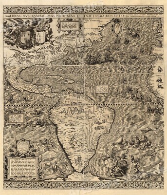
$5.95 Shipping Condition: New Location: Las Vegas, United States The New World 1562 Size: 20" x 24" 51 cm x 61 cm) x Also Available in 24" x 28" from our eBay Store This is a great Classic Map originally ... morePublished circa 1562. This Map shows the America's as it was known in the 1500's. Includes texts in cartouche. Statements of dedication, coats-of-arms, ill. of allegorical f igure"Victoria" And ill. of sailing ships at sea and imaginary marine creatures. The wording on the map reads: Americae sive qvartae orbis partis nova et exactissima descriptio/ avtore Diego Gvtiero Philippi Regis Hisp. etc. Cosmographo; Hiero. Cock excvde 1562; Hieronymus Cock excude cum gratia et priuilegio 1562" This poster. Which evokes the vivid images of a simpler time, is a custom reproduction printed on 68lb Heavyweight Enhanced Matte Art Paper. This Historic Art Print is suitable for framing. Mounting or direct display on any wall! 000 Artscape Galleries/ Posters Past More Prints and Posters Available from our eBay Store! Shipping price includes delivery confirmation. We combine shipping for multiple purchases- add $1.00 for each additional poster. All posters are professionally packaged to ensure that they arrive safely and undamaged: Your poster is first rolled and inserted into a plastic sleeve before being placed into a Heavy-Duty mailing tube for delivery. We stand behind the quality of every poster. If you are not satisfied with your purchase. Please contact us within 30 days to arrange for either an exchange or a full refund. gsrx_vers_468(GS 6.4(468)
Buy It Now
$5.95 Shipping Condition: New Location: Las Vegas, United States Year: 1589. “Vibrant and bright! Pic does not do it justice.looks amazing!”. Each of our prints are custom reproductions printed on 68lb Heavyweight Enhanced ... moreMatte Art Paper. These Historic Art Prints are suitable for framing, mounting or direct display on any wall!
Buy It Now
$8.79 Shipping Location: Greenacres, United States This map includes a legend showing the line-up of Allies and Axis as of December 1, 1942.
Buy It Now
$6.00 Shipping Location: Greenacres, United States It was engraved by William Hughes and published by Adam & Charles Black as Plate LIX inBlack's General Atlas of the World, Edinburgh, 1851. Topographical ... morefeatures are noted, with relief shown by hachure.
Buy It Now
$6.00 Shipping Location: Greenacres, United States The map was compiled by Nicolai Jonge and published in Baron Ludvig Holberg'sAn Introduction to Universal History, Copenhagen, 1757.
Buy It Now
$6.00 Shipping Location: Greenacres, United States The map was engraved by Young & Delleker and is titledOrbis Veteribus Cognitus. The coverage area extends from Ireland to North China, south to Sumatra ... moreand Central Africa, where the map labels lands inhabited by cannibals.

Buy It Now
$5.95 Shipping Condition: New Location: Las Vegas, United States Mappemonde a l'usage du Roy Size: 16" x 24" 41 cm x 61 cm) x Also Available in 24" x 36" from our eBay Store This is a great Classic ... moreMap originally Published circa 1720. This Map. By Guillaume Delisle, shows The known world of the early 1700's. This poster. Which evokes the vivid images of a simpler time, is a custom reproduction printed on 68lb Heavyweight Enhanced Matte Art Paper. This Historic Art Print is suitable for framing. Mounting or direct display on any wall! 000 Artscape Galleries/ Posters Past More Prints and Posters Available from our eBay Store! Shipping price includes delivery confirmation. We combine shipping for multiple purchases- add $1.00 for each additional poster. All posters are professionally packaged to ensure that they arrive safely and undamaged: Your poster is first rolled and inserted into a plastic sleeve before being placed into a Heavy-Duty mailing tube for delivery. We stand behind the quality of every poster. If you are not satisfied with your purchase. Please contact us within 30 days to arrange for either an exchange or a full refund. gsrx_vers_468(GS 6.4(468)
Buy It Now
$9.56 Shipping Location: Wallkill, United States
Free Shipping Location: San Antonio, United States This Map was removed from a 1898 Atlas and is in good acceptable condition. This map is not " new " or in " new " condition, it was printed in 1898. Including ... moreHundreds of RareCivil War Period United States.
$17.78 Shipping Location: Whiteside, Australia Please see pictures for condition. Everything is carefully packaged and I head to the post office a few times a week so you don’t have to wait long for ... moreyour order!I can combine postage if you are buying more than one item.See other listings for more goodies!Thank you.
Buy It Now
Free Shipping Location: Schertz, United States This is a rare and exquisite antique map from 1853, depicting the Polynesian region, including the Sandwich and Friendly Islands. The map is in excellent ... moreshape, with vibrant hand-colored details that make it a beautiful addition to any collection. Free shipping is available within the USA, while shipping costs are calculated for worldwide orders. The map was published by J.W. Lowery and is an authentic original from the 19th century. Whether you're a serious collector or just appreciate the beauty and history of antique maps, this piece is sure to impress.
Buy It Now
$5.95 Shipping Condition: New Location: Las Vegas, United States Year: 1661. Haemisphaerium Sceno Graphicum - Celestial Chart of the Zodiac. A beautiful and unique celestial chart by Henricus Hondius. Shows signs of ... morethe zodiac above “Australis Incognito” (Australia unknown) and the Southern Hemisphere.

Buy It Now
$4.59 Shipping Location: Greenacres, United States 1951 Political Wall MAP OF THE WORLD Printed in Color Decorative Border Railways Handsome fold-out lithographed map of the world in full color with decorative ... moreborder. Printed more than 61 years ago. The map opens to a very generous 26" x 41" and was compiled by the National Geographic Society and depicts the world with political boundaries as they were in the middle of the last century. The map was published as a supplement to the December 1951 National Geographic Magazine. It is drawn on a scale of 1:40.000,000, or 63.2 miles to the inch at the equator, and it shows principal railways, roads, canals, and airports. The photos below give a closer at the map's fine detail and attractive appearance. Condition: This map is in very good. Lightly used condition, with a pinhole on one fold corner in the margin, outside of the image area, and no marks. Rips, or tears. It is blank on the back, with no printing on the reverse side. This is the original. Authentic map, as published by the National Geographic Society, not a reproduction. And it is fully guaranteed to be genuine. There have been many changes in the political geography of the world since this map was printed. And we are pleased to offer it with our unconditional. Money-back guarantee. SHIPPING: We gladly ship anywhere in the World. And we use sturdy, professional packing materials to assure safe delivery. The shipping charges are as follows: Within the United States. Including Alaska, Hawaii, and APO addresses: $3.59 To Canada or Mexico: $9.79 To all other international destinations: $13.99(These charges reflect recent increases made by the United States Postal Service for international delivery. We will appreciate your prompt payment for this item. If you need more time or have any other questions about making your payment. Or if you may desire any special services, such as overnight delivery or tracking number, please contact us. Florida residents add 6.5% sales tax. Be sure to check our auction listings on eBay for other antique and collectibl
Buy It Now
$8.79 Shipping Location: Greenacres, United States Throughout the war, Harrison dazzled and educated readers ofFortune with his artistic geo-visualizations.
Buy It Now
$5.95 Shipping Condition: New Location: Las Vegas, United States Year: 1705. Each of our prints are custom reproductions printed on 68lb Heavyweight Enhanced Matte Art Paper. These Historic Art Prints are suitable for ... moreframing, mounting or direct display on any wall!
Buy It Now
$18.44 Shipping Location: WISBECH, United Kingdom CAPTION PRINTED BELOW PICTURE: 'New Guinea and the Papuan Archipelago'. DATE PRINTED: 1895. TYPE: Antique colour atlas map. VERSO: There is nothing printed ... moreon the reverse side, which is plain. AUTHENTICITY: This is an authentic historic print, published at the date stated above.
Buy It Now
$5.95 Shipping Condition: New Location: Las Vegas, United States Of allegorical f igure "Victoria", and ill. Cosmographo ; Hiero. Cock excvde 1562 ; Hieronymus Cock excude cum gratia et priuilegio 1562". Year: 1562. ... more“Vibrant and bright! Pic does not do it justice.looks amazing!”.
Buy It Now
Free Shipping Location: Carefree, United States ORIGINAL 1873 ANTIQUE WORLD MAP SHOWING MOUNTAINS, PLATEAUS AND PLAINS. ORIGINAL 1873 ANTIQUE WORLD MAP SHOWING THEMOUNTAINS, PLETEAUS AND PLAINS REGIONS. ... moreDATE 1873 NOT ON MAP. SOURCE- WARREN'S ATLAS OF PHYSICAL GEOGRAPHY.
Buy It Now
$5.95 Shipping Condition: New Location: United States Map of the World as peopled by the Descendents of Noah. Year: 1818. “Vibrant and bright! Pic does not do it justice.looks amazing!”. Each of our prints ... moreare custom reproductions printed on 68lb Heavyweight Enhanced Matte Art Paper.
Buy It Now
$6.95 Shipping Location: Dover, United States Issued 1882, Chicago by Rand McNally & Co. Original center fold as issued. Large late 19th century color lithographed map.
Buy It Now
$5.95 Shipping Condition: New Location: Las Vegas, United States This great Historic Map print shows the British Empire throughout the world exhibited in one view. Year: 1850. British Empire throughout the World exhibited ... morein one view. “Vibrant and bright! Pic does not do it justice.looks amazing!”.
Buy It Now
$5.95 Shipping Condition: New Location: Las Vegas, United States A new map of the world : with all the new discoveries by Capt. Cook. Each of our prints are custom reproductions printed on 68lb Heavyweight Enhanced ... moreMatte Art Paper. These Historic Art Prints are suitable for framing, mounting or direct display on any wall!
Buy It Now
Free Shipping Location: Schertz, United States This 1829 political map of Japan showcases the regions of Satzuma, Sikoke, and Sado with beautiful hand coloring. Created by A. Arrowsmith, chartographer ... moreto the King, and engraved by Sidney Hall, this antique original piece is a rare find for collectors and enthusiasts alike. The map measures 9x11 inches and comes with free shipping within the USA, while calculated shipping is available worldwide. Ideal for home decor or research purposes, this map is an excellent addition to any collection.
Buy It Now
$4.95 Shipping Location: Dover, United States Issued 1914, Paris by Belin. Engraved by Drioux. Lovely early 20th century color lithographed map. Centerfold as issued.
Buy It Now
$5.95 Shipping Condition: New Location: Las Vegas, United States Novissima Totius Terrarum Orbis Tabula. Each of our prints are custom reproductions printed on 68lb Heavyweight Enhanced Matte Art Paper. These Historic ... moreArt Prints are suitable for framing, mounting or direct display on any wall!
Free Shipping Location: Monroe, United States ORIGINAL 1897 ANTIQUE HEMISPHERE MAP OF THE WORLD WITH POLAR VIEWS. SCARCE AND VERY DETAILED WORLD MAP WITH EASTERN AND WESTERN HEMISPHERES, POLAR VIEWS, ... moreHIGHEST MOUNTAIN CHART AND LAND MASS/ MAP IS DFATED BELOW TITLE AT TOP.
Buy It Now
$4.55 Shipping Location: Oakland, United States This antique map of the world is a beautiful piece of history for any collector. With a colorful design and measuring 18.5x12 inches, this map from 1885 ... moreis a unique addition to any space. It features a world view and is perfect for those interested in history or geography.The map is carefully crafted with intricate details, making it a stunning decorative piece for any home or office. Its vibrant colors will add a touch of elegance to any space. This antique treasure is a must-have for any collector looking for a unique and timeless piece to add to their collection.
Buy It Now
$5.95 Shipping Condition: New Location: Las Vegas, United States “Vibrant and bright! Pic does not do it justice.looks amazing!”. This is a nicely detailed World Map by Nicolaes van Geelkercken originally created in ... more1615. The double hemispherical map of the world is surrounded by all of the signs of the zodiac.
$36.14 Shipping Location: COLCHESTER, United Kingdom THE NORTHERN HEMISPHERE. IT IS AT LEAST PARTIALLY HAND COLOURED. PUBLISHED IN LONDON BY GEORGE PHILIP. VERY CLEAN WITH NO HOLES BUT A COUPLE OF MINOR ... moreNICKS ON THE LEFT SIDE AND A SMALL TEAR OF AROUND 5 CMS ON THE CENTRE FOLD, AGAIN ON THE LEFT.
Buy It Now
$24.55 Shipping Location: Saint Louis, United States Rand McNally Map School Pull Down “World History Series” Classical Greece #1260435”X50”
Free Shipping Location: Schertz, United States This antique atlas map from 1856 features the British Isles including England, Wales, Scotland, and Ireland. Measuring 11x13 inches, it is an original ... morepiece published by S. S. Cornell. In addition to being a beautiful and historical piece, 10% of your purchase will be donated to Tunnel to Towers Charity. This map is a perfect addition to any collection and a great conversation starter. Shipping is available worldwide.
Buy It Now
$5.95 Shipping Condition: New Location: Las Vegas, United States Year: 1589. Each of our prints are custom reproductions printed on 68lb Heavyweight Enhanced Matte Art Paper. These Historic Art Prints are suitable for ... moreframing, mounting or direct display on any wall!
Buy It Now
Free Shipping Location: New York, United States Place this globe on any counter or table to show your love for traveling. Embark on an exciting adventure with this world globe decor. Experience the ... moreworld in your grasp with our decorative jet globe with stand!
Buy It Now
$5.40 Shipping Location: San Diego, United States This vintage world map is a beautiful addition to any collection. Measuring 70cm by 50cm, it features a classic Rand McNally & Co. cartographer design ... morefrom the 1970s. The map is a physical copy, in its original vintage condition, and is perfect for those interested in antique maps and cartography. Whether you're using it for decoration or for historical research, this map is sure to impress.
|
|
|
In
|
1868 Colton Map - World Flag Atlas Chart - National & Commercial Nations Country
Click Here. Double your traffic. Get Vendio Gallery- Now FREE! Lake Erie Maps& Prints! An Authentic Antique Atlas Chart of Flags: Not a Modern Reproduction! See Our Ebay Store for other! Free Shipping on Purchases of 5 or More Maps and Prints Description: It is an original elephant folio sized engraved antique atlas chart of National& Commercial Flags of All Nations over 138 years old with a centerfold as issued. It is from Colton's General Atlas. Published in New York by the Colton& Co. 1874, although the chart has a copyright date of 1868 printed on the map in small print in the bottom margin and states as"Entered according to Act of Congress in the Year 1868 by J.H. Colton in the Clerks Office of the District Court of the United States. A facsimile copy of the title page will also be included for authenticity. Overall, ... morea beautiful rare map with nice color that would frame up nicely. The US flag only has 40 stars at the time of publication. Size: The map image measures approximately 16 1/2 by 27 inches(38x68cm) on a 17 1/4 by 28" 44x71cm) page with a margin all around for framing as seen in the pic. Condition: The map is in Very Good condition for its age with a centerfold as issued. There is some minor ink residue down the middle and around the edges with a few very light handling smudges. See the pics for more on condition. Overall, a very example for its age printed on heavy paper in great shape with an antique appearance that would frame up nicely. The pics are of the actual map. Payment Details: We accept most major credit cards through Paypal and Ebay. Please ask if you have any questions about payment. International and New Bidders are welcomed and encouraged. Payment is expected within 7 days. After which Nonpaying Bidders will be reported to Ebay to recoup our listing fees. Shipping: $3.50 for First Class or $4.95 for Priority Mail with Delivery Confirmation in the USA; $4.95 for First Class International to Canada; $10 for International Airmail elsewhere in the World. We ship
|
|
|
Vintage United States & World Pull Down Map, Nystrom, Classroom School Wall Map
Graphic and vibrant vintage United States& World classroom map. Part of the Quillen-Johns American History Maps. The War Between the States" US map is shown on the top half, and"Voyages of Exploration" on the bottom. Printed/published by A. J. Nystrom. Circa 1960's. Measurements approx. 54" W(including metal frame) x 77" H. Condition notes: a couple light creases from typical use. Otherwise t his map is in fantastic shape for its age. I'm offering FREE SHIPPING within the continental U.S. Unfortunately I can't ship this map overseas. Please ask all questions PRIOR to bidding. I have a handful of other school maps. Some older, so let me know if you're looking for anything specific. Please note all sales are final& Payment is due within 24 hours of auctions end* The map will be shipped within ... more48 hours of cleared payment. Via USPS Media Mail which has an ETA of 2-9 days depending on your location.
|
|
|
1906 GERMANIA NATIONAL BANK MAP MILWAUKEE WISCONSIN 3 PAGES WORLD US WIS 22X28
Spectacular three page map with material on six sides. William Brumder(on map) was the son of George founder of the Gemania Bank and publishing business in Milwaukee and builder of the Germania Building changed to Brumder in WW I. The building still stands downtown. See the rest under Wikapedia George B. There house was a BB a few years ago and they donated a spectacular stained glass window to Grace Lutheran downtown The map is dated 1906 on front though it has 1910 census material.The front world map(Van Der Grinten's Spherical Projection) is quite detailed with military territories and French Kongo listed.The handwritten Declaration of Independence is on the back side of it. Next is a super Wisconsier Map dated 1907. On the back of that is a 1910 Gazeteerr of Wisconsin. The third page front ide is a US map with a view of the Pananama ... moreCanal. Those maps is marked engraved.The back side is census comparison for 1890 1900 and 1910. Ohter details i hope you can pick up from the pictures. If you have any questions or concerns now or during the purchase process please let us know. We provide full refunds. No sales outside the US please do not bid. We expect payment within 3 days. Wisconsin residents will pay 5.5% sales tax
|
|
|
Vintage HIGHWAY MAP OF U.S. Atlas/Map School & Library Atlas of the World 1965
HIGHWAY MAP OF UNITED STATES" Page 126 AND 127(HAS SOME BLUE INK ON SOME HWY'S IN Calif. National Park System" PAGE 128"Transcantinental Mileage Chart" Page 125 2 full page: Page 125/126 and 127/128(BACK TO BACK) Book page measurements are 21-1/2" high x 15" wide Carefully r emoved from the- School and Library Atlas of the World Printed and Bound in the United States of America by the School and Library Publishing Company Sycamore. Illinois Library of Congress Catalog Card Number: Map 62-216 Framable measurements would be approx. be 20" x 14" I'm showing the cover and title for your information only. not included) Please ask any questions regarding before purchasing. There is plenty of surrounding border for matting purposes. Some of the pages have some may have water spots. And some pages have ... morefaired better than others, all and all they have survived almost 50 years. Most of the age on the pages give the maps a well worn. Aged appearance. The colors are vibrant and the maps are still readable and framable. I will be posting more maps of states and countries. If you purchase more than one map. I will combine shipping. Please ask questions. Thank you. If you see a buy it now at the top click the BUY IT NOW button to get your purchase quicker. Note: This original antique map gives you an opportunity to examine in exquisite detail a piece of history. If you are interested in the past of this country and its people or have a desire to study where your family may have come from. Then this map gives you a rare look as the area was years ago. Once matted and framed, this map would make a perfect gift for a family member or friend. Most maps we sell come from atlases that were damaged and beyond repair. The maps often had a canvas book binding tape mounted on back along the center fold. Please if you are unhappy with your purchases. Please contact us before leaving feedback. Thank you.
|
|
|
Pull down elementary school map by RAND MCNALLY, 3 layers, WORLD, U.S., AL & HI
This is a map produced by Rand McNally. I cannot find a copyright date on this map. But I would guess 10+ years old. This map comes mounted on a spring roller. With a wood dowel at the end. This map is an elementary-age map, designed for students up to fifth grade. There are three layers to this map. The top layer is a political map of the world. The map number is#12127. The second layer is a political map of the United States. The map number is#12118. The third layer is a political map of Alaska and Hawaii. The map number is#1218. The map is listed as"markable. which means it can be marked with a dry erase marker and then wiped off. This map does show wear from general classroom use. However. There are no major defects, and this map is in good condition. This map would make a great addition for a traditional classroom. Homeschool, or ... morejust a design for your home. Shipping costs are $25 for UPS shipping in the United States. Due to the weight and size of this item. I will ship this item internationally. If you would like international shipment, just message me with your country, and I will put together a specific quote for your location. ST:83
|
|
|
Vintage 1939 World Atlas City Map Downtown Baltimore, Maryland MD World War WWII
Antique 1939 World Atlas City Map Baltimore. MD A Wonderful Gift! Great OLD Map from the"COLLIER'S WORLD ATLAS& GAZETTEER" Copyright 1939 74 Years Old! The Actual Page! NOT a Copy! Baltimore. Maryland(Contact Us For More Scans) This Page Measures About 11 x 14 1/8" Th Map Measures About 9 1/2" x 9 1/4" Map Shows Fort McHenry. Baltimore City College, Maryland Penetentiary, University of Maryland, Fifth Regiment Armory, Johns Hopkins University, Western Female High School, Confederate Monument, Cemetaries, Patapsco River, Catholic Cathedral, Parks, Etc. Very Educational. See what the City used to look like! Black& White Will look great Matted& framed A Nice Gift! A GREAT House Warming Gift! The Perfect Gift! Teachers& Politicians LOVE Them! Super For a Local Business or Office! Shipping by 1st Class ... moreor Priority Mail We Will Combine Shipping on Up To 4 Maps for the same shipping fee Email Us With Any Questions or For an International Shipping Quote Check out my other items! Be sure to add me to your favorites list! Thanks For Looking! International Buyers– Please Note: Import duties. Taxes, and charges are not included in the item price or shipping cost. These charges are the buyer's responsibility. Please check with your country's customs office to determine what these additional costs will be prior to bidding or buying.
|
|
|
SEVEN LAYER WORLD pull down school map by RANDMARK, measures 60 x 50 inches
This is a map produced by Randmark. The map does not have a copyright date. But I estimate it is probably about 15 to 20 years old. This map measures 60 inches high by 50 inches wide. It comes mounted on a spring roller. With a wood dowel at the end. There are seven layers to the map. They include: 1. United States 2. World 3. North America 4. South America 5. Europe 6. Asia 7. Africa This map shows some minor wear from general classroom use. There are no markings or tears on the map itself. However. There are some small tears on the vinyl on the back of the map. These do not go through the map, and they are not visible from the front of the map while the map is down. This map would make a great addition for a traditional classroom. Homeschool, or just a design for your home. While there are some issues, this map can still be useful. Shipping ... morecosts are $25 for UPS shipping in the United States. Due to the weight and size of this item. I will ship this item internationally. If you would like international shipment, just message me with your country, and I will put together a specific quote for your location. ST:47
|
|
|
1942 Map of Spain/Portugal (from International Atlas of the World - War Edition)
Map of Spain/Portugal(1942) This lot consists of a map of Spain/Portugal(a page from the"New International Atlas of the World" Measures 10.5" x 14.5" Suitable for framing. Shipped Flat. Please check out my other ebay auctions by clicking the Logo below. Thanks for looking and a BIGGER Thanks for Buying. Important Information Please try to pay within 5 days of winning your lot(or at least email me) Lots usually ship within 2 business days after payment. If you have any issues please let me know and I WILL CORRECT IT. I combine items to reduce shipping charges. Note: colors may differ slightly from picture due to lighting. Computer color resolution or shadowing. I will leave feedback when you are completely satisfied and feedback is left for me. Thanks for your interest. The tinman Please check out my other fine TM auctions ... morePowered by The free listing tool. List your items fast and easy and manage your active items.
|
|
|
1942 Map of British Isles (from International Atlas of the World - War Edition)
Map of British Isles(1942) This lot consists of a map of British Isles(a page from the"New International Atlas of the World" Measures 10.5" x 14.5" Suitable for framing. Shipped Flat. Please check out my other ebay auctions by clicking the Logo below. Thanks for looking and a BIGGER Thanks for Buying. Important Information Please try to pay within 5 days of winning your lot(or at least email me) Lots usually ship within 2 business days after payment. If you have any issues please let me know and I WILL CORRECT IT. I combine items to reduce shipping charges. Note: colors may differ slightly from picture due to lighting. Computer color resolution or shadowing. I will leave feedback when you are completely satisfied and feedback is left for me. Thanks for your interest. The tinman Please check out my other fine TM auctions ... morePowered by The free listing tool. List your items fast and easy and manage your active items.
|
|
|
1942 Map of Japan (from International Atlas of the World - War Edition)
Map of Japan(1942) This lot consists of a map of Japan(a page from the"New International Atlas of the World" Measures 10.5" x 14.5" Suitable for framing. Shipped Flat. Please check out my other ebay auctions by clicking the Logo below. Thanks for looking and a BIGGER Thanks for Buying. Important Information Please try to pay within 5 days of winning your lot(or at least email me) Lots usually ship within 2 business days after payment. If you have any issues please let me know and I WILL CORRECT IT. I combine items to reduce shipping charges. Note: colors may differ slightly from picture due to lighting. Computer color resolution or shadowing. I will leave feedback when you are completely satisfied and feedback is left for me. Thanks for your interest. The tinman Please check out my other fine TM auctions Powered by The ... morefree listing tool. List your items fast and easy and manage your active items.
|
|
|
THREE LAYER pull down school map by Nystrom, TEXAS, WORLD, & U.S. 65 x 72 inches
This is a map produced by Nystrom. The map does not have a copyright date. But I estimate it is probably about 10 to 15 years old. This map measures 65 inches high by 72 inches wide. It comes mounted on a spring roller. With a wood dowel at the end. There are three layers to the map. They include: 1. Texas(Map#1PS42) 2. World(Map#1SR991) 3. United States(Map#1SR1) This map shows some minor wear from general classroom use. There is a very small tear on the World map on the left-hand side at the very bottom of the map. This map retails for approximately $455. This map would make a great addition for a traditional classroom. Homeschool, or just a design for your home. While there are some issues, this map can still be useful. Shipping costs are $25 for UPS shipping in the United States. Due to the weight and size of this item. I will ship this ... moreitem internationally. If you would like international shipment, just message me with your country, and I will put together a specific quote for your location. ST:49
|
|
|
World Map - 2003 - HUGE Large Detailed Vivid Colors- 28" X 42.5"
~~~~~~~~~~~~~~~~ ~~~~~~~~~~~~~~~~ Thank you for viewing my Collectible Map Auction! Satisfaction Guaranteed* ~Rare and Quality Items~ Fast& Free Shipping~ ~~~~~~~~~~~~~~~~ ~~~~~~~~~~~~~~~~ Photos: ~~~~~~~~~~~~~~~~~~~~~~~~~~~~~~ Approximate Size: 28" X 42.5" ~~~~~~~~~~~~~~~~ ~~~~~~~~~~~~~~~~ ~ Pick up this Map for your Collection ~. While digital maps are great. There is still nothing like holding a'real' map in your hands! ~~~~~~~~~~~~~~~~ ~~~~~~~~~~~~~~~~ If you have any other questions. Do not hesitate to ask! Trusted Ebay Seller Since 2004* Check out my other auctions! ~~~~~~~~~~~~~~~~ ~~~~~~~~~~~~~~~~ Please note: Single maps under 9 ounces will be mailed via first class mail. Those over 9 ounces(or combined orders over 9 ounces) will be mailed via standard mail. Unless other services are purchased. I will be more ... morethan happy to ship any single map via Priority Mail when the price exceeds $50 at the buyer's request. If no request is made. The map will ship through normal means. Insurance will be included for free on these purchases. Buy 5 Items and Get one Free(of average or lessor value) Just let me know what item you want(any as long as it is not an auction with bids) and I will include that item in your order. Powered by The free listing tool. List your items fast and easy and manage your active items.
|
|
|
Vintage 1942 World War WWII Atlas City Map Pittsburgh, PA Penn Pennsylvania OLD
Great Gift! Vintage 1942 World Atlas City Map Pittsburgh. PA Penn. Great OLD Map from the"COLLIER'S WORLD ATLAS& GAZETTEER" Copyright 1942 World War II Era 71 Years Old! The Actual Page! NOT a Copy! Pittsburgh. Pennsylvania(Contact Us For More Scans) This Map Measures About 10 3/4 x 14 1/8" Map Shows Points of Interest. Parks, Cemetaries, Rivers, University of Pittsburgh, Hospitals, Schools, Bedford Dwellings, St. Michaels Orphan Asylum, Pitt. Stadium, Bureau of Mines, Carnegie Library, Mt. Washington, City Hall, Railroads, National Tube Co. Jones& Laughlin Steel Co. National Casket Co. Keystone Lumber Co. Etc. Very Educational. See what the City used to look like! WWII Era Black& White Will look great Matted& framed(see all photos) A Nice Gift! A GREAT House Warming Gift! The Perfect Anytime Gift! Teachers& ... morePoliticians LOVE Them! Super For a Local Business or Office! Shipping by 1st Class Mail We Will Combine Shipping on Up To 4 Maps for the same shipping fee Email Us With Any Questions or For an International Shipping Quote Check out my other items! Be sure to add me to your favorites list! Thanks For Looking! International Buyers– Please Note: Import duties. Taxes, and charges are not included in the item price or shipping cost. These charges are the buyer's responsibility. Please check with your country's customs office to determine what these additional costs will be prior to bidding or buying. Certain images and/or photos used in this template are the copyrighted property of JupiterImages and are being used with permission under license.
|
|
|
1909 US Map, World Map, and entire US Battleship Fleet on voyage around world
You are bidding on a 1909 two page map showing the United States. World, and the Atlantic Battleship Fleet of the United States on its voyage around the World. I showed the back with the ships and admirals first. The battleships included the Connecticut, Georgia, Louisiana, Wisconsin, Kansas, Nebraska, Virginia, Illinois, Minnesota, New Jersey, Ohio, Kearsarge, Vermont, Rhode Island, Missouri, and Kentucky. It lists the vessels of the US Navy by Name, keel laid, displacement tons, speed in knots, horsepower and cost. The cost of the Alabama in 1896 was 2.65 million dollars. It also shows a group of the Battleship Captains with a Aug 1908 copyright. Some pictured are Rear Admiral CN Thomas, Rear Admiral Richard Wainwright, Rear Admiral Seaton Schroeder, and Rear Admiral Chas S Sperry. Page 1 shows the Map of the United States with different ... morelists. It shows the President as Theodore Roosevelt and lists the officers of the Army and the Navy. Another page shows Data concerning the Atlantic Fleet in a voyage around the World. Another page shows an index of all chief cities in the US and population. Great two sided maps over 100 years old. Very Very neat Any questions, please email me before bidding. It will be rolled and mailed in a mailing tube for $5.00.
|
|
|
1914 MAP OF THE WORLD * George F. Cram Co. * Full Color Lithograph
Auction Wizard 2000 Listing Template- AW2KLOT#6852 Please note that Customs delays for international shipping have been SIGNIFICANT lately- days or even weeks longer than they should be! Please take this into consideration Our goal is 5 star service! If you feel we have not lived up to a 5 star rating. Please contact us as we only want 100% satisfied customers and NO misunderstandings! Description below pictures* 1914 MAP OF THE WORLD* George F. Cram Co. Full Color Lithograph* $74.95 An Original Vintage Antique Map: Not a Reproduction! See Our Ebay Store for other Antique Maps! Free US Shipping on Purchases of $100 value or more of Maps and Prints Description: This is an authentic antique map approximatley 113 years old! Map Maker/Publisher: George F. Cram. 1914. Detailed map of the World with details. Full color lithograph. Detailed map ... moreof the United States with details. Blank on reverse. The map is not mounted. Matted or framed and is being sold as a single sheet as shown in the first picture. Size: Map measures approximately 30 1/2" x 18 3/4" 77.5 x 47.6 cm) as seen in the pictures. Condition: This map is in very good condition. It is very clean and still has strong presence. Strong colors. Doublepage map with fold at center as seen in the pictures. Some small tears and minor chips along edges not affecting map image. It is basically as seen in the pics. Very clean and would frame up nicely. See pictures for more on condition. The pictures shown are of the actual print being sold. Shipping: Please use the calculator under the"Shipping and payments" tab above to determine shipping for your location. All packages are sent with Delivery confirmation where possible. We always combine shipping. So on multiple items please wait until we send you an invoice with the correct shipping applied. Maps and Prints will be shipped either flat or rolled depending on the items being shipped. We use only sturdy shipping materials to make sure the package arrives at its destination in undamaged condition. Ins
|
|
|
Vintage 1941 world physical-political school map 64x45", A.J. Nystrom & Co WOW!
Old colorful vintage 1941 school map. Large size of the world physical-political, edited by V.C. Finch, Professor of Geography, University of Wisconsin, Equatorial Scale, 1:25,344,000 of 400 miles to the inch. Van der Grinten Projection. Published by A.J. Nystrom& Co. Chicago. This map was cut and mounted on oil cloth so it could fold and was portable and it has metal brass grommets on the top so it could be hung as was typical of the time for classrooms. Neat old one. Has some brown paint splotch on the back. But at least it doesn’t show on the front. Neat big one for your wall. Colorful. Definitely used condition. Not pristine, but has a lot of character. Has dark spots on back. Possibly mildew, not sure, but will leave this to next owner. Still usable display condition. Was used in Texas classroom. Size ~ 64x45” Gorgeous and fun one ... moreto hang on the wall- a great piece of collectible history. Don’t miss out. No reserve! US ship only. No apo, $12 s/h priority mail g.RcmdId ViewItemDescV4,RlogId p4%60bo7%60jtb9%3Fuk%601d72f%2Bjw%60hquvg%3Eg-13f9f7b00cb-0xf9-
|
|
|
1ELS991 NYSTROM PULL DOWN 2 MAP SET WORLD AND UNITED STATES US HERFF JONES, INC
1ELS991 nystrom PULL DOWN 2 map set World and United States US herff JONES. INC Offered for your consideration is a very nice pull down 2 map set of(1) the world and(2) the United States. The one of the world shows the political boundaries of each country and the United States map shows the states and their capitals. It's in very good used condition. The backside of the map does have some marks but they are not readily visible when the map is installed as they are on the back and top of the roll. There are a couple of small(1/2” or so) marks on the front of the map which might be possible to remove buy the winning bidder. The third and final thing is there is a small quarter size tear in the bottom of the lower map near the wood. It is an easy repair with strong clear tape on each side of the map. The surface of this map measures about ... more65" across and is about 53" tall. It also includes the built in mounting bracket so it's ready to install. These maps are still available and the list price on the Nystrom web site is $335.00. The below brief description was taken from their web site. Early learners are captivated by these maps' bright colors. Huge size, and simple, easy-to-read text. Maps are strong, durable, and markable. World& U.S. map combination. 65" x 53" mounted on spring roller Please let the photos guide your bidding and contact me with any questions. Shipping will be 25.00 PLEASE NOTE THAT I SHIP ONLY TO THE CONTINENTAL UNITED STATES.
|
|
|
HUGE World US United States Map George F. Cram Pull Down School Wall Maps (2)
Not exactly the map you are looking for? Please check my other listings as I have hundreds of pull down wall maps in stock and will be listing new ones almost every day! Many modern and vintage Nystrom maps of the world. Asia, Canada, the United States, Europe and Africa along with some from Rand McNally, The Denoyer Geppert Company, The George F. Cram Company and more. I will gladly combine shipping on these maps whenever possible! Offered is a large and colorful 2 map se t of United States of America and the World. All the maps are on one spring loaded roll. And you pull down one at a time with the other automatically rolling behind the first. It's a George F. Cram map and is in fair condition with some flaws from use. There are two small areas that have been taped at the lower corner of the world map and there are other cosmetic marks ... morethat are mostly on the backing and not visible when the map is deployed. The surface of this map measures about 64" across and is about 48" tall. It also includes the built in mounting bracket so it's ready to install. US/World Cram Contact us: If you have any questions about this item or any of my other listings please feel free to email through the site at any time or text/call me personally on my cell at(248) 924-0554(Between 7 AM and 11 PM Eastern) Combined Shipping: Most of the time I can combine shipping if items are purchased from multiple listings or auctions. If you would like a combined shipping quote please email me a list of the items that you would like to purchase. The quantity of each and your city, state and zip code( and country if applicable) I will try and get back you as quickly as possible. My apologies. But due to the size of these maps I can on offer overseas shipping. Returns: In the unfortunate event that the item you purchased needs to be returned please send me an email so that we can make the arrangements. I accept returns on most of my items and when available can offer replacements/exchanges as well.
|
|
|
Large Vintage World Map by George Cram Pull Down School Wall Chart
Here's a large pull down map of the the World by George F Cram company in good condition. The actual map printed area is roughly 64" wide by 48" tall. Can't find a date on this anywhere but it does include the USSR. Comes attached to metal bracket. Thanks for looking!
|
|
|
New World & U.S. Advanced Physical-Political 4-Wall Map Combo new in box
4 maps for one great price! Get complete coverage of the world with the Advanced Physical-Political 4-Wall Map Combo. 4 map sheets. Including one of the world, one of the United States, one of Alaska and Hawaii and one of Arizona. They are spring-mounted together with sturdy steel rollers and pull-down rods for easy hanging and display in the classroom. Roll up style shade) Product Description Achievement Series map features: Nine different colors show nine different elevation levels· Four different colors show four ocean depths(only three appear on the U.S. map) Major physical features labeled· Durable. Markable, and washable· Spring-mounting with sturdy steel rollers and pull-down rods for easy hanging and display· Dimensions: 70" x 52" World map features: Bright. Contrasting colors and shaded relief for a ... morethree-dimensional look· Clearly indicated political boundaries. Country names, equator, prime meridian, tropics, and circles· Visually accurate Robinson Projection· Plate tectonics thematic map that shows plates. Earthquakes, and volcanoes· North and South Polar View maps at the same scale as the world map· Generous scale(1"=316 miles) Geared for students from 6th through 12th grade U.S. map features: National parks and Continental Divide shown· Easy-to-read legend with more than 20 different map symbols defined· Digital cross-section of the United States with major physical features and ocean floors· Glossary of terms from map legends on Alaska/Hawaii sheet· Thematic maps of U.S. population and hazardous waste sites· Table comparing Alaska and Hawaii statistics· Generous scale(1"=316 miles) Geared for students from 6th through 12th grade Arizona map features: Colorized relief to depict the state's terrain and topography· All counties clearly labeled with bold boundary lines· Colorful thematic maps including: environments and Native American groups· Easy-to-read legend with physical and political
|
|
|
1960 Ca Map, Mt St. Helen Map before volcano, 2 World Maps with Soviet Union
These 4 old maps and 1 brosure are in good condition. You get a 1960s CA map. 2 vintage world maps with the soviet union,etc and a map and brosure of Mt. St. Helens before it blew up.
|
|
|
CRAM WORLD / U.S. POLITICAL MAP...PULL DOWN DOUBLE MAP
Nice CRAM school map. TWO MAPS.WORLD and U.S. We can't get this to wind back up so you will have to hand wind it. Measures 64 wide x 48 long.
|
|
|
BUFFALO MAP New York City Vintage - 1947 World Atlas - Detailed Excellent
1947 World Atlas Map of. BUFFALO Second largest city in New York Featuring points of interest. Parks and principal buildings, including detailed street names. Niagara River. Peace Memorial Bridge, Delaware Park, The University of Buffalo Detailed Map from Collier's World Atlas and Gazetteer. Carefully removed. With plenty of room for framing& matting, Map measures approximately 9.5" x 12" Page measures 11" x 14.5" ~ From a dry desert and smoke free environment ~ To view other maps for sale. Click on the link below: http:search.stores.ebay.com/search/search.dll?fsoo=1&fsop=1&query= MAP&saprchi=&saprclo=&sid=12609324&sofp=0&srchdesc=y" src =" MAP"
|
|
|
VINTAGE 12" TIN LITHO 1950's WORLD GLOBE GUSTAV BRUECKMANN METAL STAND MAP
i000000. Click to Enlarge Click to Enlarge Click to Enlarge Click to Enlarge VINTAGE 12" TIN LITHO 1950's WORLD GLOBE GUSTAV BRUECKMANN METAL STAND MAP HERE IS A NICE VINTAGE WORLD GLOBE IN GREAT CONDITION. IT IS 15 1/2" TALL AND THE METAL STAND STILL HAS THE 4 LITTLE RUBBER FEET. THERE IS WEAR TO THE BRASS AND TO THE LITHO. NOTHING VERY MAJOR JUST DUE TO AGE. YOU MIGHT WANT TO CLEAN IT UP WE WILL LEAVE THAT TO THE NEW OWNER. IF YOU HAVE AND SPECIFIC QUESTIONS PLEASE EMAIL US. ALL ITEMS ARE BEING SOLD AS FOUND. WE WILL BE GLAD TO COMBINE ON SHIPPING. ~) SEE OUR OTHER AUCTIONS FOR MORE GREAT ITEMS. WE WILL COMBINE ON SHIPPING. WE TAKE PRIDE IN ALL ITEMS WE OFFER FOR SALE ON EBAY AND ALL ITEMS COME TO YOU FROM A NON SMOKING ENVIRONMENT. PLEASE. FEEL FREE TO ASK US ANY QUESTIONS YOU MIGHT HAVE: USPS See Below For Amount. Don't ... moreForget to Check Out our eBay Store for our! PayPal. DO NOT DUPLICATE OR COPY! Template Made By: © InkFrog.com Auction Templates. Logos, Store fronts and more! inkfrog terapeak.
|
|
|
TEXAS, WORLD, AND UNITED STATES MAP by CRAM, 3-layer laminated map, NEW 66 x 48
This is a map produced by Cram. This map measures 48 inches high by 66 inches wide. It comes mounted on a spring roller. With a wood dowel at the end. There are three layers to the map. These include a Texas map. A United States map, and a World map. This map is new. And it has never been used in a classroom. It is still in its original box. This map would make a great addition for a traditional classroom. Homeschool, or just a design for your home. While there are some issues, this map can still be useful. Shipping costs are $25 for UPS shipping in the United States. Due to the weight and size of this item. I will ship this item internationally. If you would like international shipment, just message me with your country, and I will put together a specific quote for your location. ST:159/160
|
|
|
MODERN EDUCATIONAL SYSTEMS Pull Down Map of POLITICAL WORLD Model 30-25 school
MODERN EDUCATIONAL SYSTEMS POLITICAL WORLD MAP FREE SHIPPING IN THE USA EXPEDITED& WORLDWIDE SHIPPING AVAILABLE Email with any questions THIS IS A GENTLY USED MAP MAP is APPROX. 61 inches wide X 45 inches high Unit still works from the spring action release overall length of mounting bracket is approx. 64 inches Powered by
|
|
|
MODERN EDUCATIONAL SYSTEMS PullDown Roll up Map of the World Model 81-05 school
MODERN EDUCATIONAL SYSTEMS WORLD MAP FREE SHIPPING IN THE USA EXPEDITED& WORLDWIDE SHIPPING AVAILABLE Email with any questions THIS IS A GENTLY USED MAP MAP is APPROX. 61 inches wide X 42 inches high Unit still works from the spring action release overall length of mounting bracket is approx. 64 inches Powered by
|
|
|
1913 Original Vintage Map THE WORLD Commercial Languges / WORLD State Organiz
Offered here is a old map of the areas(back to back) The map measures approx. 6 x 8 inches The map is in good condition. Clean, no stains, no markings and would frame nicely Check out my STORE for a great selection of maps Bid on more maps and SAVE on S&H
|
|
|
US WESTERN HEMISPHERE DEFENSE MAP World War II WWII Rand McNally No Reserve
US WESTERN HEMISPHERE DEFENSE MAP World War II WWII Rand McNally No Reserve. Halcyon Rare Books. Inc. Call us at 615-983-6460 for more information Item Description: U. S. Defense Map and Western Hemisphere Strategic Bases Map by Rand McNally Published by Richfield Richlube Company. World War II era map showing military establishments in the US during the War. List of the events of the war. Printing of the Monroe Doctrine. Informative. Measures 26.5 x 20 inches. Two-sided. A few tears along some of the folds. Rubbing and toning. Fair to good condition. Shipping Policy: RETURN POLICY: We ship everyday domestic and international via USPS or UPS. Most items are packaged in a box with bubble wrap and other packing materials for maximum protection. Please feel free to contact us with any questions or prefer to use a different carrier. We can accommodate ... moreyour special needs! We do offer combined shipping on items. If you are bidding on multiple items. Contact us so we know that is what you want to do. If after you have received your item you desire to return it. Please contact a member of our staff via phone, email, or eBay message IMMEDIATELY. We request after you contact us that you return the item within 14 days. We will issue the refund by method of payment or by PayPal. We will provide you with the information needed to process the return and send it back to us via UPS to ensure it is returned to us as quickly and safely as possible. WE ACCEPT PAYPAL AND ALL MAJOR CREDIT CARDS DIRECT! As with all of our items. We stand behind what we sell. We would like to take a moment to remind you that an eBay auction is a buying experience and not a"buy, use and return" experience. Please ask questions before you bid if you have them. Please bid based upon what is actually DESCRIBED and SHOWN in our photographs. All items are sold"AS IS" unless you find our written description and/or photos do not match what you purchased. inkfrog terapeak. I000000. InkFrog Analytics.
|
|
|
Rand McNalley Wall World map
This map is old. Not sure how old. Has some crease tears other then that Good Condition. Smoke-Free home
|
|
|
Vintage Map of the World Hallmark School Classroom Original Tube Colorful Hang
A vintage Hallmark School Classroom Home colorful graphics Map of the World in its original tube. Designed by John Stewart. Measures about 18 x 27. We are also listing a Map of the USA. Please pay within 3 days or contact us if you will be unable to make immediate payment. Failure to do so will result in us filing an unpaid item case and relisting the item. Thanks!
|
|
|
Hammond's THE WORLD ALMANAC U.S. MAP
Hammond"The World Almanac" U.S. Map Facts and Map State Information. Statistics Sells for $8.953 ISBN 13 9 780843 70944 5 PAY PAL ONLY Smoke Free Environment First Class Shipping
|
|
|
World political pull down map 65 x 52
You are looking at a 1992 political map of the world. It is by Modern Educational Systems. Inc. This is a World Map. The map measures about 65 inches wide x 52 inches long. It does not have the metal housing that will allow the map to be pulled down or rolled back up automatically. This shows all the continents. The map is very clean and in excellent condition, with very few blemishes. It has been used, but looks new. This map can be marked on. If you have any questions, please ask. Thanks for looking and good luck bidding.
|
|
|
Farm and Fireside Magazine Wisconsin/U.S./Reconstructed Europe/World Map
National farm magazine Farm and Fireside poster map circa 1920-23. Measures approximately 25.75" x 36" Maps produced by the Kenyon Company of Des Moines. Iowa. Wisconsin map shows congressional districts and steamship routes on the Great Lakes. The United States map shows banking towns, railroads, rivers, mountains, steamship lines, and belts of standard time. The European map shows reconstruction after WWI. The World Map on Mercators Projection shows steamship lines in red. Also has pictures of all world and United States flags and portraits of world leaders of the time. Condition is not the best. Creasing, missing parts on the bottom of the Wisconsin page, and some tape repair to some areas. It was rolled up in a cardboard tube for storage and will be delivered as such. Shipping to destinations within the continental United States ... morewill be $7 USPS economy shipping. Destinations outside the continental United States will require additional postage. International bidders please confirm shipping costs before bidding. Thanks for looking. RcmdId ViewItemDescV4,RlogId p4%60bo7%60jtb9%3Fvo%7B%3Dd70f%2Bf54%3E-1446c066804-0x10a-
|
|
|
Vintage Industrial Wall Pull Down School World Map Geography
This world map was picked up at a school auction. The wood pull bar is 66" long and the map itself is 61" long x 46" tall. The map is made to mount on a map rack. Which we have in stock at the moment(though it may have sold by now, please check our other items) but it also has two 3/4" holes 36" apart that could be used to mount the map to a wall. Bulbs are not included unless specified I also have a wonderful selection of other industrial artifacts. Please feel free to browse! Please give me a call with any questions you may have 815-299-7625 Happy bidding PLEASE READ THE FOLLOWING VERY CAREFULLY There is a $10.00 handling charge on all international orders. We can accept NO RETURNS. REFUNDS, ETC. ON INTERNATIONAL ORDERS. We are in no way responsible for damages that may occur during transit. International orders ... moreshould expect to have an additional 3-5 day handling time. BUYERS ARE RESPONSIBLE FOR ANY DUTIES AND TAXES THAT MAY APPLY. SHIPPING PRICES REFLECT THE FACT THAT ALL OF OUR ITEMS ARE INSURED FOR THEIR VALUE. SHIPPING COSTS ARE AN ESTIMATED REPRESENTATION; ACTUAL COSTS MAY VARY BASED ON ITEM AND DESTINATION. You are welcome to pick up your items with an appointment with no additional charges. Skidding charges will still apply. NO PAYPAL FOR WILL CALLED ITEMS INTERNATIONAL CUSTOMERS: Items shipped to some countries cannot always be insured for their full value. In these cases. We will insure them to the full extent available, but will not be responsible for additional damages above the available insured amount. International items are shipped via USPS; please become familiar with the insurance policy associated with your country. All packages will be shipped out on the first Tuesday or Friday following payment All items are described to the best of our ability and sold‘AS PICTURED’ TAKE NOTE: Our items are vintage and should be expected to be in such condition. Many of our items have wear and tear appropriate for their age. Including minor rusting, dings, scratches, etc. We do our
|
|
|
Vintage 1937 Pre World War WWII Atlas State Map MAINE MARYLAND DELAWARE McNally
Pre World War II map from Colliers Atlas and Gazetteer. c 1937, Full page measures 11 x 14 1/4 inches. Maps on both sides of the page. One is Maine and the other combines Maryland and Delaware. If you need additional pictures or if I left out any other information you may need. Please let me know. I am always happy to answer any questions. 1st class mail will be in a padded and reinforced envelope. I am listing a large number of these maps plus other paper ephemera. So please check out my other auctions. I am always happy to combine shipping. Thank you.
|
|
|
Vintage Industrial World School Pull Down Wall Map Educational Systems 30-21 Art
This World Map was made by Modern Educational Systems. Model no. 30-21. It was made in 1988, just before the Berlin Wall came down, and you can see that East and West Germany are still divided on the map of Europe. The pull bar is 65" and some tape repairs have been made along the back of it. The map itself is 61 1/4" L x 46 1/2" T. The map is made to mount on a map rack but it can be hung on a wall using two 3/4" holes spaced 36" apart in the metal support. Someone had made tape repairs to the back of the map with a strong tape of some sort- it's silver tape, but looks different than duct tape. The repairs seems secure. I also have a wonderful selection of other industrial artifacts. Please feel free to browse! Please give me a call with any questions you may have 815-299-7625. Happy bidding. PLEASE READ THE ... moreFOLLOWING VERY CAREFULLY. There is a $10.00 handling charge on all international orders. We can accept NO RETURNS. REFUNDS, ETC. ON INTERNATIONAL ORDERS. We are in no way responsible for damages that may occur during transit. International orders should expect to have an additional 3-5 day handling time. BUYERS ARE RESPONSIBLE FOR ANY DUTIES AND TAXES THAT MAY APPLY. SHIPPING PRICES REFLECT THE FACT THAT ALL OF OUR ITEMS ARE INSURED FOR THEIR VALUE. SHIPPING COSTS ARE AN ESTIMATED REPRESENTATION; ACTUAL COSTS MAY VARY BASED ON ITEM AND DESTINATION. INTERNATIONAL CUSTOMERS: Items shipped to some countries can not always be insured for their full value. In these cases. We will insure them to the full extent available, but will not be responsible for additional damages above the available insured amount. All packages will be shipped out on the first Tuesday or Friday following payment. All items are described to the best of our ability and sold‘AS PICTURED’ TAKE NOTE: Our items are vintage and should be expected to be in such condition. Many of our items have wear and tear appropriate for their age. Including minor rusting, dings, scratches, etc. We do our best to note any cosmetic
|
|
|
Nystrom School Pull Down Sculptural Relief Markable Map WORLD & CITIES (51SR988)
VINTAGE 4 LAYER NYSTROM MARKABLE MAP OF WORLD& MARKABLE MAP OF UNITED STATES/ CITIES.MEASURES approx. 63 inches wide X 54 inches tall, both maps can be written on and are in good condition. Spring is in great shape;1?RcmdId ViewItemDescV4,RlogId p4%60bo7%60jtb9%3Feog4d72f%2B%3E%3B1%3F-14523689c4a-0x112-
|
|
|
1920's LINEN BACK NEW WORLD SERIES SCHOOL MAP UNITED STATES OF AMERICA 39 x 51
1920's NEW WORLD SERIES SCHOOL MAP OF THE UNITED STATES OF AMERICA THE MAP MEASURES ABOUT 39" BY 51" AND IS LINEN BACKED IT HAS BRASS EYELETS FOR HANGING IT THE MAP HAS SOME STAINING BUT IS STILL COLORFUL SHIPS TO USA ONLY 8% NY RESIDENT TAX
|
|
|
1934__RCA__RADIO_TOURS _WORLD-WIDE_MAP FULL_COLOR__ SHORTWAVE CALL_SIGNS_& KILOC
World Wide/ Radio/ Tours/ Maps Showing Radio/ Stations of United States/ Canada& Mexico/ and/ Principal Short-Wave Stations/ of the World by Location/ Call Letters& Kilocycles Hagstrom Co; NY; 1934/ First Edition Very Good In Original Soft Covers Single sheet. 18.5 x 26.25" printed on both sides in full color and folded to 12 panels. The exterior has two title panels. A one panel ad for the sponsoring RCA Cunningham radio tubes and three panels explaining how to use an RCA antenna system to receive international broadcast stations. The remaining six panels are the 10 x 15" map showing short wave stations around the world. Indexed by call letters and kilocycles. The interior is the map of the US. Canada and Mexico, locating broadcast stations in 1934. Again indexed by call letters and kilocycles. By bidding on this item. ... moreYou agree to these Terms of Sale_ U.S.A. TERMS of SALE_ Shipping See Ebay Ad for Cost( Post Office Only) We Pack for the Apocalypse) PayPal Preferred Pre-Payment must be received within 7 days of the close of auction or eBay notifications will be generated. Returnable If not as described. WITH careful packing& prior notification. For Refund of Bid Price width: 750px; border="2" cellpadding="10" Foreign Terms of Sale These terms apply to ALL bidders registered outside the U.S.A. Depending on the nature of the item. We automatically accept bids from Canada/ United Kingdom/ Germany/ Japan/ Australia If you do not live in those nations& have a PayPal account& wish to bid on our sales. Just ask to be put on our eBay list of pre-approved bidders Please ask at least one day before the sale closes. Just use Ebay's" link at the ebay ad. FOREIGN payments MUST be made with PayPal PayPal payment must be initiated within 3 days of the close of auction. FOREIGN SHIPPING ALL FOREIGN SHIPMENTS OVER 4 POUNDS MUST BE BY GLOBAL PRIORITY MAIL For heavy books this will be a LARGE SURCHARGE on top of your bid. Please take this into consideration when bidding. E
|
|
|
Antique 1920 Geographical Pub. Global Map World Leaders & Census,US map 2 pages
Here is an antique 1921 Geographical Publishing Global World Map with World Leaders.1920 United States Census,Washington state census and automobile highways, flags from all 48 states from old estate,in very good condition considering the age,has a few small tears at bottom,top edge has metal band with 2 loops for hanging. Folds out 2 full pages with images on all pages, Measures 36" x 28" President Harding was in office in 1921,also many other world leaders pictured with country flags. Quite a nice historical,political map for any collection. Will ship rolled up. WEights apx 1 lbs shipped weight.
|
|
|
VINTAGE ROOSEVELT HIGHWAY WORLD'S FAIR ROUTE U.S. 6 FOLDOUT MAP AND BROCHURE
VINTAGE ROOSEVELT HIGHWAY WORLD'S FAIR ROUTE U.S. 6 FOLDOUT MAP AND BROCHURE click to Enlarge click to Enlarge click to Enlarge click to Enlarge click to Enlarge Description. YOU ARE BIDDING ON JUST ONE OF MANY VINTAGE MAPS/BOOKS FROM A NICE ESTATE. CONDITION VARIES AND ARE BEING SOLD AS IS AS FOUND IN THE ESTATE- SEE PHOTOS! STATED SHIPPING FEE IS BY THE PACKAGE(NOT BY THE ITEM) PURCHASE 1 OR 100 ITEMS AND THE SHIPPING IS STILL JUST $3 TOTAL. EVEN IF YOU FILL A BOX SO BE SURE TO CHECK OUR OTHER LISTINGS! MULTIPLE BUYERS PLEASE WAIT FOR AN UPDATED, DISCOUNTED INVOICE. ALL OUR MAPS. BOOKS, DVDs, MANUSCRIPTS, MAGAZINES, NEWSPAPERS, POSTCARDS& RELATED EPHEMERA, STAMPS, TRADING CARDS, COINS& TOKENS ARE AUTHENTIC AND 100% GUARANTEED FOR ANY REASON. 10+ YEARS OF STELLAR EBAY FEEDBACK LET YOU BID WITH CONFIEDENCE! SEE MANY PHOTOS FOR ... moreCONTENT& CONDITION AS WE SELL AS FOUND DIRECTLY FROM THE ESTATE! ALL MY AUCTIONS FROM THIS WONDERFUL ESTATE ARE BEING SOLD AS IS. AS FOUND. I TOOK MANY PHOTOS INSTEAD OF GOING INTO GREAT DETAIL DUE TO THE LARGE VOLUME OF ITEMS STILL TO LIST. ALL AUCTIONS ARE 100% GUARANTEED FOR ANY REASON UNLESS I KNOW YOU SENT ME BACK AN ITEM THAT WAS NOT THE ITEM I SENT YOU. AS YOU CAN SEE, ALL MY VINTAGE ITEMS FROM THIS ESTATE HAVE MULTIPLE PHOTOS FOR YOU TO GET A GREAT IDEA OF CONTENT& CONDITION. RETURNS MUST BE RECEIVED BY ME WITHIN 14 DAYS OF AUCTION END SINCE ONCE I PAY THE CONSIGNER OF THE ESTATE, THE SALE IS FINAL. THE EBAY PROCESS SHOULD BE SIMPLE.I LIST WITH MANY PHOTOS, YOU BID, YOU PAY ASAP, I PROMPTLY SEND YOUR PACKAGE WITH FREE DELIVERY CONFIRMATION AND IN SOME CASES FREE INSURANCE WHEN VALUE WARRANTS- IF YOU NEED ADDITIONAL HAND HOLDING OR FORSEE ANY ISSUES THAT MAY DEVIATE FROM THIS QUICK& EASY PROCESS PLEASE RECONSIDER. WE HAVE OVER 10.000 ESTATE ITEMS STILL TO LIST SO MARK US AT A FAVORITE SELLER JUST AS 1000+ REPEAT BUYERS HAVE! I WILL GLADLY COMBINE SHIPPING! ANY ITEM BID IN EXCESS OF $50 WILL BE INSURED FOR FREE.ANY ITEM BID IN EXCESS OF $750 WILL BE SENT USPS O
|
|
|
Nystrom Pull Down School Map~World & United States ~Markable~1ELS991~2 Available
Nystrom World& United States Pull Down Flip School Map 1ELS991 Herff Jones Education System This unit consists of 2 maps. One of the World, and flip to the other of the United States Excellent Condition Measures 68" Wide(2 available) No Markings noted on this Map Excellent Condition We only charge actual shipping costs! What it costs to ship is what you pay! Shipping offered with listing is by media mail Please note that USPS media mail can be slow and take up to 10 business days. Priority shipping services are available. At actual cost. If Buyer prefers Priority Shipping please write to let us know and we will correct Payment invoice to reflect such.
|
|
|
Vintage Colored Map of The World AT&T 800 International Map 27 x 17
Map of the World. At&T International 800. In very good shape. Obviously creases from having been folded. Opens out to 27" x 17 1/4" wide. Bright and undamaged. g6.RcmdId ViewItemDescV4,RlogId p4%60bo7%60jtb9%3Fuk%601d72f%2B%3Eg6%3E-1473c4a50b4-0x108-
|
|
|
RAND McNally World Series Eastren & Southren Asia Pull Down Map
RAND McNally World Series Eastren& Southren Asia Pull Down Map. This Item Is in Excellent Condition& Mounting Bracket is Attached.This Map Is Markable. Use water Soluble Marker. THANK YOU FOR LOOKING AT OUR LISTING AND HAVE A GOOD DAY. Your purchase will be professionally packed and shipped via USPS.UPS,or another service. Whichever is the most cost effective for you! Please email with any questions and review auction terms below prior to bidding. 5R Processors A sset R ecovery T eam Auction Terms: Shipping Policy: We only ship to the United States. We ship using UPS and USPS when available. We do not ship to P.O. Boxes. Street addresses are required for all shipments. Discounts for combined shipments are available and must be paid for with-in the same transaction. Email your seller. Prior to making payment, to verify shipping costs ... moreincluding oversized items shipping freight. PLEASE NOTE: Items sold at $1.000 and over will be automatically shipped with a signature required for delivery, unless otherwise requested, at no additional charge to the buyer. The“signature required for delivery” option is available to all buyers for items sold at less than $1,000 for a charge of $3.25, paid by the buyer. Please contact your seller prior to payment to arrange any changes. Customer Pickup: Purchases can be picked up between the hours of 8:00a.m. 3:30p.m. CST Monday through Friday. Buyers must email in advance to plan a pick up time and date. Items may still be subject to a handling fee. Payments: Payments are due within 5(five) days of auction close. We prefer Paypal. We do not accept checks. And are not responsible for late or missing payments. Office Hours: Our office hours are 7:30a.m. to 4:00p.m. Monday through Friday. We are not available for email outside business hours. Or over major holidays. Emails sent during off hours will be answered the following business day. Warranty Information: Warranties. If available, are listed in each item description. If you do not agree with these terms, do not place a bid.
|
|
|
Large / National Publishing Co. / U.S. and World Wall Map 2 Sided / 62" x 40"
Large. Two sided, antique wall map of of the United States and World in good condition for age(see Condition) Map was published by the National Publishing Co. U.S. side has copyright of 1920 and the World side has copyright of 1919. Soup cans not included. Sorry for the poor pics, I will replace them when I get the chance.
|
|
|
1944 Map World War II United States Map GI Soldiers Home State Cartoon YYA1
Home ~ Affiliations ~ Discounts ~ FAQs ~ Grading and Certification ~ Premium Shipping ~ About Us VINTAGE ART& ADVERTISING CURATED COLLECTIONS 1944 Map World War II United States Map GI Soldiers Home State Cartoon YYA1 Details Year: 1944 Type: Original Halftone Map Grade: Near Mint/ Very Fine Authentication: Dual Certificates Image: Two-Color Approximate Size(inches) 20.5 x 14 Approximate Size(cm) 52 x 36 Description and Condition This is an original 1944 two-color halftone map. Created by Sergeant Ralph Stein of Yank: The Army Weekly Magazine. Depicting what GIs fighting overseas during WWI miss the most about each individual State. Period Paper is thrilled to release this new collection of YANK: The Army Weekly Magazine which includes covers. Pinups, and maps from 1943-1944. This collection offers a unique look at the life of an average ... moreAmerican GI on the front lines of World War II, from New Guinea to Monte Casino, as well as some of the things that kept them ticking, including numerous attractive pinup girls. Many a soldier probably dreamed of getting mail from one of these beauties! This collection is sure to fascinate anyone interested in the world's most devastating conflict, and the people who participated in it. CONDITION This 69+ year old Item is rated Near Mint/ Very Fine. Light aging throughout. No creases. Original portfolio crease. No surface rub. No tears. No water damage. Please note this map has staple holes along the original center crease. To find other items from this specific collection in our eBay store. Please. This piece was illustrated by Stein. Ralph. YYA1A6B30C44 zz10000. 228174_YYA1_073 Product Pricing& What We Deliver At times we receive inquiries about our pricing. Especially for vintage advertising or historical halftone prints, and are asked why our prices are consistently higher than some other sellers of similar items. For the first five years of our business, we asked our primary consumer base what they wanted. Our primary consumers- historical societies, historians,
|
|
|
TEXAS, WORLD AND UNITED STATES MAP by CRAM, 3-layer map, measures 69 x 46 inches
This is a map produced by Cram. The map does not have a copyright date. But I estimate it is probably about 15 to 20 years old. This map measures 44 inches high by 69 inches wide. It comes mounted on a spring roller. With a wood dowel at the end. There are three layers to the map. These include a Texas map. A United States map, and a World map. The United States map is a political relief map. This map has been used in a classroom. So it shows general signs of wear from being used in a school. There are no specific defects like tears, stains, or rips. Overall, it is in good condition. This map would make a great addition for a traditional classroom. Homeschool, or just a design for your home. While there are some issues, this map can still be useful. Shipping costs are $25 for UPS shipping in the United States. Due to the weight and size of ... morethis item. I will ship this item internationally. If you would like international shipment, just message me with your country, and I will put together a specific quote for your location. ST:211.212
|
|
|
1911 US Census era Antique MAP CENTRAL EUROPE color WORLD history ORIGINAL 69
x This Auction is for an Unframed ORIGINAL ANTIQUE MAP NOT a reproduction as detailed below. I have many additional maps from this volume Please see my store for what is available. The prints are much sharper that the image shown here. Taken from: People's Handy Atlas of the World By Geographic Publishing Company 1910 Census Edition 1911 Map Size 5.5 X 7.75 inches. WE HAVE MANY HISTORIC MAPS. PRINTS AND OTHER ITEMS ON MANY DIFFERENT SUBJECTS Please check out store for additonal products IF YOU ARE UNHAPPY WITH YOUR PURCHASE SIMPLY RETURN IT AND WE WILL REFUND YOUR MONEY. Powered by The free listing tool. List your items fast and easy and manage your active items.
|
|
|
1844 ORIGINAL MAP World as know to Ancients Mitchell's Ancient History Atlas 1
This Auction is for an Unframed ORIGINAL ANTIQUE MAP NOT a reproduction as detailed below. I have many additional maps from this volume Please see my store for what is available. The prints are much sharper that the image shown here. Taken from: Mitchell's ancient atlas. Classical and sacred, containing maps illustrating the geography of the ancient World, as described by the writers of antiquity; also, the political divisions, cities, towns, places distinguished by remarkable events. As determined by modern observations; together with a table of the corresponding ancient and modern names of the places engraved in the maps. The whole accompanied by a descriptive geography, embellished with numerous engravings of remarkable events, views of important cities, noted structures, and various interesting antique remains. By S. Augustus Mitchell. ... morey Map of the World as known to the ancients. Engraved to illustrate Mitchell's ancient geography. with) Comparative map of the World. with) The World according to Ptolemy. Drawn& engraved by J.H. Young. 1844 Map Size 11.5 X 9.25 inches WE HAVE MANY HISTORIC MAPS. PRINTS AND OTHER ITEMS ON MANY DIFFERENT SUBJECTS Please check out store for additonal products IF YOU ARE UNHAPPY WITH YOUR PURCHASE SIMPLY RETURN IT AND WE WILL REFUND YOUR MONEY. Powered by The free listing tool. List your items fast and easy and manage your active items.
|
|
|
GEORGE F. CRAM Markable Map of the WORLD Model No. 3008
CRAM WORLD MAP FREE SHIPPING IN THE USA EXPEDITED& WORLDWIDE SHIPPING AVAILABLE Email with any questions THIS IS A GENTLY USED MAP. MAP IS APPROX. 51 inches wide X 42 INCHES high Unit still works from the spring action release overall length of mounting bracket is approx. 56 inches,RcmdId ViewItemDescV4,RlogId p4%60bo7%60jtb9%3Fuk%600d72f%2B%3F0%3C%3E-14842220304-0xf7-
|
|
|
OLD GRAND MCNALLY WORLD SCHOOL MAP
THIS HERE IS AN OLD GRAND MCNALLY WORLD SCHOOL MAP. IN GOOD SHAPE. MINER WARE AND HAS A LITTLE TEAR ON THE BOTTOM. IT WAS GLUED ON TO A THICK PIECE OF CARD BOARD. APPROX 52 X 34 PLEASE CHECK OUT ALL OUR OTHER SCHOOL MAPS. THANKS FOR LOOKING. GOOD LUCK
|
|
|
Nice colored map of the State of Michigan -1907 Universal Atlas of the World
Up for sale is a nice antique map of the State of Michigan. Map was published in 1907 in the Universal Atlas of the World. Published by Rand. McNally& Company, Chicago-New York. It measures approximately 11 x 14(including the border areas) On one side is a map of the State of Michigan It also lists some population data along the sides of the map. On the back is a map of the main portion of Detroit. It lists some Street data along the sides. Overall map is in good condition. Some light browning around the edges. Some dings and tears along the edges. But it does not affect the map. Will look very nice framed. Note also that while I have included a picture of the title page it is not included in the sale as it is a reference piece to determine authenticity for several other maps. I would be happy to include a copy if requested. Please see ... moremy store for other great items. Inventory R-10
|
|
|
Scandecor World Map Wall Mural #3909 12' 8 3/4" x 9' In Tube
Scandecor World Map Wall Mural#3909 12' 8 3/4" x 9' In Tube.Printed In Germany.Complete.Very Good Shape.Buyer Pays $16.95 S&H.
|
|
|
Vintage School roll-down Map Denoyer Geppert large World Beginners 1971
This is a very large 64 1/2" wide roll-down map of the"beginners" World atlas.This includes the metal frame and wood"pull down" dowel.This was made for School use circa 1971.This has bright colors and no damage other than normal wear and tear(see photos)pulls down and up just as expected.This is suitable for framing and makes a great decorator item with a history!This will be shipped in a heavy-duty 5" one-piece cardboard tube with ends(5" x 72"Good Luck.
|
|
|
1903 Cram's Atlas Map 2 Page,The World, Nice Color,Suitable To Frame 14"X21"
Description: This is a double page from a Geo. F. Cram Atlas dated 1903. George F. Cram(1842-1928) Served in the during the. After the war ended. Cram joined his uncle's map business in 1867. Two years later, he formed the George F. Cram Co. which became a leading map firm and first American firm to publish a world. It employed a relief process Photos are of actual product you will be receiving. Measurement: 14 1/2” x 21 1/4” Condition: Very Good.No rips or tears. Slight discoloring due to age. Suitable for framing. Shipped folded flat. Payment: PayPal Only. Shipping: Buyer responsible for all shipping upgrades. Will combine items from multiple purchases whenever possible to save on your shipping costs. Worldwide Shipping. International First Class. Please advise prior to purchasing if you would prefer upgraded shipping. Returns: Accepted ... morewithin 14 days. Return shipping policy: Buyer’s responsibility if product sold as described; however buyer had a change of mind. Should item sold not arrive as described; return shipping will be seller’s responsibility. Comments: We try to be as descriptive as possible; however we are not graders. Should you have any questions. Please do not hesitate to ask. Thank you. On Feb-27-13 at 16:12:43 PST. Seller added the following information:
|
|
 |