-
Christian Collectibles
-
Christian Sheet Music
-
Vatican Stamps
-
Vatican Coins & Paper Money
-
Antiques
-
Antiquities
-
Architectural & Garden
-
Decorative Arts
-
Ethnographic
-
Furniture
-
Maps, Atlases & Globes
-
United States (Pre-1900)
-
United States (1900-Now)
-
AK, HI
-
AL, FL, GA, MS, NC, SC
-
AR, IA, KS, LA, MO, NE
-
AZ, CA, CO, NM, NV, UT
-
CT, MA, ME, NH, RI, VT
-
DC, DE, MD, NJ, NY, PA
-
ID, OR, WA
-
IL, IN, MI, OH, WI
-
MN, MT, ND, SD, WY
-
OK, TX
-
VA, WV, KY, TN
-
Entire US
-
United States (Date Unknown)
-
Africa
-
Asia
-
Australasia/ Oceania
-
Canada
-
Central America/ Caribbean
-
Europe
-
India
-
Ireland
-
Mexico
-
Middle East
-
North America
-
South America
-
United Kingdom
-
Maps on CD
-
World Maps
-
Globes
-
Mixed Lots
-
Reproductions
-
Price Guides & Publications
-
Other
|
In
Order by: Available to: This site contains affiliate links for which I may be compensated
|
Buy It Now
$4.89 Shipping Location: Cuyahoga Falls, United States The map is printed in a county map format and is perfect for those interested in the history and geography of Ohio.

Buy It Now
$13.71 Shipping Location: MANCHESTER, United Kingdom Ireland; Ireland North West sheet Antique colour map. 1895 Title of map: Ireland; Ireland North West sheet' The image below shows an enlarged cross ... moresection from the centre of the map to show the level of printed detail. This map is folding hence the centrefold line may show on the image below: DATE PRINTED: 1895 IMAGE SIZE: Approx 43.0 x 33.0cm. 16.75 x 13 inches(Large) Please note that this is a folding map. ARTIST/CARTOGRAPHER/ENGRAVER: Unsigned PROVENANCE: New Complete Atlas of the World" Published by George W. Bacon. London. Please note that virtually all antique and vintage maps and prints have been extracted from books, atlases or newspapers. TYPE: Antique colour map VERSO: There is nothing printed on the reverse side. Which is plain CONDITION: Good; suitable for framing. Please check the scan for any blemishes prior to making your purchase. Virtually all antiquarian maps and prints are subject to some normal aging due to use and time which is not obtrusive unless otherwise stated. I offer a no questions asked return policy- see below. AUTHENTICITY: This is an authentic historic print. Published at the date stated above. I do not offer reproductions. It is not a modern copy. The term'original' when applied to a print means that it was printed at the first or original date of publication; it does not imply that the item is unique. Print' means any image created by applying an inked block to paper or card under pressure by any method including wood engraving, steel engraving, copperplate, wood cut and lithography. REMARKS: FRANCE: Gravures et Cartes anciennes. DEUTSCHLAND: Alte Lankarten und Stadt ansichten. ITALIA: Stampe& Mappe antiche. ESPAÑA: Mapas antiquos y impresiones antiguas. E and OE. Force Majeure. English law shall apply. RETURNS POLICY: I offer a no questions returns policy. All I ask is that you pay return shipping and mail back to me in original condition. Suitably packed& insured, within 14 days of receipt.
Buy It Now
$13.71 Shipping Location: MANCHESTER, United Kingdom He based his atlases on the plates used by Edward Weller for his Weekly Dispatch Atlas. from The Ordnance Survey, edited and published by G.W. Bacon, ... moreLondon, 1895.
Buy It Now
$13.71 Shipping Location: MANCHESTER, United Kingdom He based his atlases on the plates used by Edward Weller for his Weekly Dispatch Atlas. from The Ordnance Survey, edited and published by G.W. Bacon, ... moreLondon, 1895.
Buy It Now
$6.00 Shipping Location: Blue Bell, United States CONDITION: MAP IS IN GOOD. OVER 100 YEARS OLD! Over 100,000,000 served. FREE scheduling, supersized images. MULTIPLE WINS.
$6.00 Shipping Location: Blue Bell, United States CONDITION: MAP IS IN GOOD. OVER 100 YEARS OLD! Over 100,000,000 served. FREE scheduling, supersized images. MULTIPLE WINS.
Buy It Now
$6.00 Shipping Location: Blue Bell, United States CONDITION: MAP IS IN GOOD. OVER 100 YEARS OLD! Over 100,000,000 served. FREE scheduling, supersized images. MULTIPLE WINS.
Buy It Now
$8.00 Shipping Location: Charlton City, United States THE NEW ENGLAND COMMERCIAL ROUTE SURVEY MAP NH VT ME MA CT 1914. THE MAP IS APPROX 3 FEET 6 INCHES WIDE AND APPROX 4 FEET IN HEIGHT. THIS MAP IS VINTAGE ... moreORIGINAL COPY RIGHTED IN 1914 BY THE BULLARD CO. BOSTON MASS. AS YO CAN SEE THERE ARE SOME TEARS IN THE SEAM A EASY REPAIR BUT I AM NOT A EXPERT I WILL LEAVE THAT TO YOU. SOLD AS IS YOU WILL HAVE TO DETERMINE THE GRADE AND CONDITION. THERE IS A INDEX ON THE REVERSE IN REGARDS TO POPULATION. DISTANCE TABLE. STORED IN CLEAR TOTE GARAGE TOTE 98
Buy It Now
$4.99 Shipping Location: United States
6h 9m 3s 0 bids
$32.94 Now
$4.95 Shipping Location: Walpole, United States Engraved two-sided folding map. Southern New England on one side with a map of the state of Maine on the opposite side.

Buy It Now
$4.13 Shipping Location: Ellsworth, United States RARE 1905 THE NEW ENGLAND COMMERCIAL AND ROUTE SURVEY RARE 1905 36X33 MAP NEW ENGLAND COMMERCIAL ROUTE SURVEY RAILROAD ELECTRIC ROADS The New England ... moreCommercial and Route Survey. Showing all Post Offices. Railroads, Electric Roads in operation and proposed, GOOD ROADS, Population(showing latest Mass. Census) and a Comprehensive Distance Table. 1905. Map with some small fold tears, no loss. Exterior boards with some wear and scuffing. Everything being said map remains better than average. A fantastic find for the collector or anyone interested in this subject matter. Not common. As of this listing we have been unable to locate another of these maps via the internet at any price. The map measures 36 inches tall by 33 inches wide. Thanks! Please read carefully before bidding or buying: Payment· I accept PayPal only· Payment is due within 48 hours of auction end or action will be taken per Ebay policy· Consider a bid or purchase as a legal and binding contract· By bidding/winning this auction you agree to the terms above and Ebay/PayPal policy Shipping· Shipping only to lower 48 states· NO INTERNATIONAL SHIPPING Unless otherwise stated. If I do ship out of the U.S. I can not guarantee delivery or condition of item if it delivers. Any insurance. Delivery confirmation or other shipping services are included in the shipping cost. Shipping rates are not negotiable so please keep this in mind before you bid or buy. I do combine shipping but is dependent on the items sold. Please inquiry for any combined shipping before placing bid. All shipping charges listed are the best estimate. We do our best to keep shipping cost as that– shipping– for certain items it is hard to determine due to zones used by shipping services. We do our best to keep cost in line with shipping services. Items are not insured unless noted in the auction description. No local pick-ups. Other terms and conditions· We do our best to give an accurate description of the item listed. We inspect and test(if possible) our i
$6.00 Shipping Location: Blue Bell, United States CONDITION: MAP IS IN GOOD. OVER 100 YEARS OLD! Over 100,000,000 served. FREE scheduling, supersized images. MULTIPLE WINS.
Buy It Now
$6.00 Shipping Location: Greenacres, United States This highly detailed map is drawn on a scale of 1:1,140,000. The map is titledColton's Florida.
Buy It Now
$13.71 Shipping Location: MANCHESTER, United Kingdom He based his atlases on the plates used by Edward Weller for his Weekly Dispatch Atlas. from The Ordnance Survey, edited and published by G.W. Bacon, ... moreLondon, 1895.
Buy It Now
$13.71 Shipping Location: MANCHESTER, United Kingdom He based his atlases on the plates used by Edward Weller for his Weekly Dispatch Atlas. from The Ordnance Survey, edited and published by G.W. Bacon, ... moreLondon, 1895.
Buy It Now
$13.71 Shipping Location: MANCHESTER, United Kingdom He based his atlases on the plates used by Edward Weller for his Weekly Dispatch Atlas. from The Ordnance Survey, edited and published by G.W. Bacon, ... moreLondon, 1895.
Buy It Now
$25.00 Shipping Location: Belvedere Tiburon, United States In 1857, Baker drew and published a large birds-eye-view of the young ‘City of the Plain’ (printed as a lithograph by Britton & Rey in San Francisco), ... morewhich achieved enormous popular success.
Buy It Now
$18.95 Shipping Location: YORK, United Kingdom Beautiful large old map on quality paper EXCELLENT condition and rescued from a disbound Atlas: THE TIMES SURVEY ATLAS OF THE WORLD 1920 THIS MAP IS AN ... moreORIGINAL - OVER 90 YEARS OLD **FEATURES SUPERB DETAIL** Published by The Times and J.G. Bartholomew , London, 1920. , a double page authentic and original colour map reduced from national surveys and the special surveys of travellers and explorers ~ The Edinburgh Geographical Institute This single fold sheet measures approximately Full Title: World - commerce. Commercial development. (with) Occupations. (with) Means of traffic EXCELLENT CONDITION ~ VERY MINOR HANDLING & AGE MARKS Please email with any questions regarding this item (Times Survey} If you like the item, but do not like the price, then make a realistic offer to us using the.
Buy It Now
$25.00 Shipping Location: Belvedere Tiburon, United States The Coastal Survey Office was originally established for hydrographical mapping and largely employed hydrographers and hydrographic engineers. Map of ... moreEastern Virginia Compiled from the best authorities and printed at the Coast Survey Office, A.D. Bache, Supdt.
Buy It Now
Free Shipping Location: Northford, United States 1799 & inset Map, Continuation of the Potomac River from Fort Cumberland. Nothing is known of his youth and education. He is known to have published Joseph ... moreCollyer's 1772New System of Geography in London, and his own work is probably descended from Collyer's.

Buy It Now
$3.12 Shipping Location: MANCHESTER, United Kingdom TENBURY 1902 SHEET NUMBER 19.01 BRAND NEW. UNUSED IN SUPERB CONDITION This map is taken from the 1/2500 plans and reproduced by Alan Godfrey at about ... more15 inches to the mile. It is highly detailed, even showing individual houses, schools, works, churches and covers an area of about one and a half square miles This highly detailed map is split between Worcestershire and Shropshire. Coverage stretches from Burford House eastward to Kyrewood House. And northward to Spurtree. Features include the town centre of Tenbury with all buildings neatly shown. Cross Street, Market Street, Teme Street, The Court, St Mary's church, Workhouse, Kyrewood House, Goff's Free School, Berrington House, Teme Bridge, etc. The River Teme runs across the map. On the Shropshire side features include railway with Tenbury station, Swan Hotel, St Mary's Cottage Hospital, Dean Park, part of Burford parish, Old School House, Rose& Crown inn, Bank Farm, Burford House, St Mary's church Burford, Lockyers etc. We also include a commercial directory for Tenbury plus a 1906 railway timetable for the Bewdley-Tenbury-Woofferton line. EMAIL ME IF YOU HAVE ANY QUESTIONS ON karenswift@blueyonder.co.uk These maps will provide hours of fascination for historians. Transport buffs and genealogists or for anyone who just wants to see what their area looked like in the days gone bye and are terribly addictive.you have been warned! I AM NOW SELLING MORE MAPS FROM AROUND THIS AREA. NO EXTRA P+P FOR MORE ITEMS BOUGHT.SAME P+P FOR 1 ITEM AS IT WOULD BE FOR 100! SEE MY SHOP FOR MORE MAPS FROM THIS AND OTHER AREAS. CLICK HERE U.K. BUYERS CAN PAY EASILY BY BANK TRANSFER. IT'S FREE FOR YOU AND ME! Pay me with PayPal. I don't charge my buyers extra! Powered by.RcmdId ViewItemDescV4,RlogId p4%60bo7%60jtb9%3Feog4d72f%2Bf7%60%3E-145455de9df-0x10e-
Buy It Now
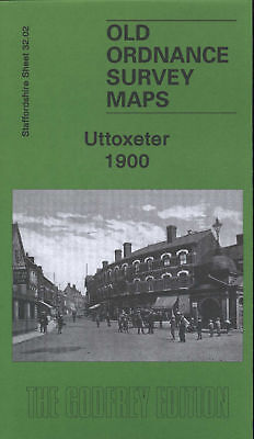
$3.12 Shipping Location: MANCHESTER, United Kingdom UTTOXETER 1900 SHEET NUMBER 32.02 BRAND NEW. UNUSED IN SUPERB CONDITION This map is taken from the 1/2500 plans and reproduced by Alan Godfrey at about ... more15 inches to the mile. It is highly detailed, even showing individual houses, schools, works, churches and covers an area of about one and a half square miles This highly detailed map covers the Staffordshire town of Uttoxeter. The town centre is shown. With individual buildings neatly delineated, and coverage extends northward to The Heath and The Wharf, westward to Oldfields Hall, southward to Balance Hill. Features include railways and station, Ash Lea, cemetery, Leighton Iron Works, Market Place, St Mary's church, Cattle Market, Mount Pleasant, brewery, Manor House, The Hall, Carter Street, Cheese Factory, Park Place, Workhouse, Moorhouse Farm etc. On the reverse we also include a commercial directory for the town in 1912. NO MORE P+P FOR ANY OTHER ITEMS BOUGHT JUST DO ALL OF YOUR SHOPPING WITH ME FIRST THEN GO THROUGH CHECKOUT WHERE YOU WILL SEE THE ONE P+P CHARGE EMAIL ME IF YOU HAVE ANY QUESTIONS ON karenswift@blueyonder.co.uk These maps will provide hours of fascination for historians. Transport buffs and genealogists or for anyone who just wants to see what their area looked like in the days gone bye and are terribly addictive.you have been warned! SEE MY SHOP FOR MORE MAPS FROM THIS AND OTHER AREAS. CLICK HERE U.K. BUYERS CAN PAY EASILY BY BANK TRANSFER. IT'S FREE FOR YOU AND ME! Pay me with PayPal. I don't charge my buyers extra! Powered by
Buy It Now
$10.00 Shipping Location: Chicago, United States The State of New York from New and Original Surveys under the direction of J.H. French. Date: 1860 (dated) Syracuse, NY. A colossal map of the Empire ... moreState of New York as it was one year prior to the outbreak of the Civil War.

Buy It Now
$25.00 Shipping Location: Belvedere Tiburon, United States This is an exquisite full-color Reproduction printed on heavyweight(7.0 MIL) Glossy Photo Paper. These maps are perfect for framing. Or a wonderful and ... moreunique gift for family members, friends or co-workers! All Information is Carefully Compiled from Actual Surveys Original Maps are often difficult to find and usually have fold lines. Identifying stamps or markings, tears, ragged edges, and assorted other natural signs of age that detract from their beauty. All of our maps have been professionally restored to depict their original beauty, while keeping all historical data intact. These maps are fabulous pieces of history full of information useful to Historians. Genealogists, Cartographers, Relic Hunters, Others. They make fascinating conversation pieces and splendid works of art for the home or office. This historic map captures history through a unique perspective. Event maps are authentic records of battles fought throughout the history of American wars. Dating back to the French& Indian War and recorded through the eyes of the noble military men themselves. They would make an excellent addition to any history buff's collection. Map Size: 23.00 x 27.56 Site Specifics To This Map Are: Arundel. Petersburg, Albany, Boston, Plymouth, Woodstock, Danbury, Harlem, Newcastle, Canterbury, and several other cities and towns throughout eastern North America. The following towns are featured: Province of New Hampshire. Part of New York, Colony of Connecticut, Province of Massachusets, Eastern Part of Massachusets, Rhode Island, Long Island, Hudson River, Connecticut River, Kusumpe Pond, Sunape Pond, and Lake George. Also Features a close-up insert of the town of Boston. This Map is Situated in: Eastern United States SKU: REWA0107 and Powered By: `0d.RcmdId ViewItemDescV4,RlogId p4%60bo7%60jtb9%3Fuk.rp*fc%3E%3E%600d-13deb7fd3e6-0xf7-
Buy It Now
$24.86 Shipping Location: WORCESTER, United Kingdom Printed 1920. The map has a central fold. The map pictured is the one you will receive.
Buy It Now
$25.00 Shipping Location: Belvedere Tiburon, United States Colton published two editions of the map in New York in 1865. This is the rarer first edition, distinguished by differences in the geography on the map ... moreitself, and also the lack of floral decorative border in the margins.

Buy It Now
$4.36 Shipping Location: MANCHESTER, United Kingdom HORSHAM(SOUTH) 1938 SHEET NUMBER 13.12 BRAND NEW. UNUSED IN SUPERB CONDITION This map is taken from the 1/2500 plans and reproduced by Alan Godfrey at ... moreabout 15 inches to the mile. It is highly detailed and covers an area of about one and a half square miles This detailed map covers much of the town centre. Continuing south to Chesworth Farm, west to Tanbridge House, east to Hornbrook Farm. Features include Carfax, North Street, St Mary's church, Bishopric, West Street, East Street, North Brewery, cemetery, New Street, Brighton Road, Oakhill, New Town, site of Chesworth House. The commercial directory, entries K-Z, is concluded on the reverse. A Fantastic detailed Map which is invaluable for family genealogy and historic studies THIS MAP LINKS UP WITH SUSSEX SHEET 13.08 HORSHAM(NORTH) WHICH I AM ALSO SELLING ON EBAY RIGHT NOW. NO MORE P+P FOR ANY OTHER ITEMS BOUGHT! Contact me on karenswift@blueyonder.co.uk if you have any questions SEE MY SHOP FOR MORE MAPS FROM THIS AND OTHER AREAS. CLICK HERE I AM NOW SELLING MORE MAPS FROM AROUND THIS AREA. NO EXTRA P+P FOR MORE ITEMS BOUGHT. SAME P+P FOR 1 ITEM AS IT WOULD BE FOR 100! U.K. BUYERS CAN PAY EASILY BY BANK TRANSFER. IT'S FREE FOR YOU AND ME! Pay me with PayPal. I don't charge my buyers extra! Powered by

Buy It Now
$3.12 Shipping Location: MANCHESTER, United Kingdom ABERSYCHAN(NORTH) 1899 SHEET NUMBER 18.06 BRAND NEW. UNUSED IN SUPERB CONDITION This map is taken from the 1/2500 plans and reproduced by Alan Godfrey ... moreat about 15 inches to the mile. It is highly detailed, even showing individual houses, schools, works, churches and covers an area of about one and a half square miles This detailed map covers the northern part of Abersychan. With coverage stretching from Bluett's Bridge northward to Pen-y-lan and Old Furnaces. Features include the Garndiffaith area. Victoria Village, Tal-y-Waun, Brightstown, GWR railway but no stations, Rising Sun Bridge, LNWR Abersychan Extension railway, mineral railways, Lower Varteg Colliery, Varteg Coal Crusher, Golynos, chemical works, old shafts, Hen-felin, Balance Houses, Garndiffaith Junction, viaduct, Avon-lwyd, etc. On the reverse we include directories of Garndiffaith and Talywain. The map links up with sheet 18.10 Abersychan South to the south which I am selling separately on Ebay right now These maps will provide hours of fascination for historians. Transport buffs and genealogists or for anyone who just wants to see what their area looked like in the days gone by and are terribly addictive.you have been warned! NO MORE P+P FOR ANY OTHER ITEMS BOUGHT, PLEASE DO ALL OF YOUR BUYING FIRST AND WHEN YOU HAVE FINISHED THEN GO THROUGH THE CHECKOUT WHERE YOU WILL SEE THE P+P SET AS ONE. DON'T BUY ONE THEN PAY FOR IT, THEN BUY ANOTHER AND PAY FOR IT, AND SO ON OTHERWISE EBAY SEE IT AS DIFFERENT TRANSACTIONS AND THE POSTAL DISCOUNTS WON'T KICK IN, YOU NEED TO DO ALL OF YOUR SHOPPING FIRST BEFORE GOING THROUGH CHECKOUT EMAIL ME IF YOU HAVE ANY QUESTIONS ON karenswift@blueyonder.co.uk SEE MY SHOP FOR MORE MAPS FROM THIS AND OTHER AREAS. CLICK HERE U.K. BUYERS CAN PAY EASILY BY BANK TRANSFER. IT'S FREE FOR YOU AND ME! Pay me with PayPal. I don't charge my buyers extra! Powered by
Buy It Now
$13.71 Shipping Location: MANCHESTER, United Kingdom He based his atlases on the plates used by Edward Weller for his Weekly Dispatch Atlas. from The Ordnance Survey, edited and published by G.W. Bacon, ... moreLondon, 1895.
Buy It Now
$13.71 Shipping Location: MANCHESTER, United Kingdom He based his atlases on the plates used by Edward Weller for his Weekly Dispatch Atlas. from The Ordnance Survey, edited and published by G.W. Bacon, ... moreLondon, 1895.
Buy It Now
$13.71 Shipping Location: MANCHESTER, United Kingdom He based his atlases on the plates used by Edward Weller for his Weekly Dispatch Atlas. from The Ordnance Survey, edited and published by G.W. Bacon, ... moreLondon, 1895.
Buy It Now
$13.71 Shipping Location: MANCHESTER, United Kingdom He based his atlases on the plates used by Edward Weller for his Weekly Dispatch Atlas. from The Ordnance Survey, edited and published by G.W. Bacon, ... moreLondon, 1895.
Buy It Now
$25.00 Shipping Location: Belvedere Tiburon, United States The main part of the map depicts the river from Anticosti Island to Quebec, and it is flanked, above and below, by a number of insets (one based on D’Anville’s ... moremap, and four others depicting important stretches of the river with greater detail).
Buy It Now
Free Shipping Location: Saugerties, United States Division of the State Geological Surveys. #23 Manganese Deposits of Western Virginia - 1922; 1 Large Map of Western Virginia and One Chart. #12 The Coal ... moreResources of the Clintwood and Bucu Quadrangles.
Buy It Now
$8.79 Shipping Location: Greenacres, United States
Buy It Now
$11.84 Shipping Location: ILKLEY, United Kingdom Title / Subject: 'Durham'.

Buy It Now
$4.36 Shipping Location: MANCHESTER, United Kingdom HORSHAM(SOUTH) 1938 SHEET NUMBER 13.12 BRAND NEW. UNUSED IN SUPERB CONDITION This map is taken from the 1/2500 plans and reproduced by Alan Godfrey at ... moreabout 15 inches to the mile. It is highly detailed and covers an area of about one and a half square miles This detailed map covers much of the town centre. Continuing south to Chesworth Farm, west to Tanbridge House, east to Hornbrook Farm. Features include Carfax, North Street, St Mary's church, Bishopric, West Street, East Street, North Brewery, cemetery, New Street, Brighton Road, Oakhill, New Town, site of Chesworth House. The commercial directory, entries K-Z, is concluded on the reverse. A Fantastic detailed Map which is invaluable for family genealogy and historic studies THIS MAP LINKS UP WITH SUSSEX SHEET 13.08 HORSHAM(NORTH) WHICH I AM ALSO SELLING ON EBAY RIGHT NOW. NO MORE P+P FOR ANY OTHER ITEMS BOUGHT! Contact me on karenswift@blueyonder.co.uk if you have any questions SEE MY SHOP FOR MORE MAPS FROM THIS AND OTHER AREAS. CLICK HERE I AM NOW SELLING MORE MAPS FROM AROUND THIS AREA. NO EXTRA P+P FOR MORE ITEMS BOUGHT. SAME P+P FOR 1 ITEM AS IT WOULD BE FOR 100! U.K. BUYERS CAN PAY EASILY BY BANK TRANSFER. IT'S FREE FOR YOU AND ME! Pay me with PayPal. I don't charge my buyers extra! Powered by
Buy It Now
$6.00 Shipping Location: Denver, United States Blank reverse. Topography and near-shore hydrography are shown in buff contour relief. (First edition map of a portion of northeastern Massachusetts including ... moreportions of Middlesex, Essex and Worcester Counties with the Cities of Lowell and Lawrence).
Buy It Now
$13.71 Shipping Location: MANCHESTER, United Kingdom He based his atlases on the plates used by Edward Weller for his Weekly Dispatch Atlas. from The Ordnance Survey, edited and published by G.W. Bacon, ... moreLondon, 1895.
Buy It Now
$13.71 Shipping Location: MANCHESTER, United Kingdom He based his atlases on the plates used by Edward Weller for his Weekly Dispatch Atlas. Edited by G.W. Bacon, published by G.W. Bacon & Co. Ltd, London, ... more1899. This is an original antique, 121 years old.
Buy It Now
$23.74 Shipping Location: TIVERTON, United Kingdom SOUTH ATLANTIC OCEAN - HARBOURS AND ANCHORAGES IN SOUTH GEORGIA - 1962. Not so many of these charts printed because of the location's remoteness. This ... morechart is for Harbours and Anchorages in South Georgia.
Buy It Now
$6.00 Shipping Location: Denver, United States (First edition map of a portion of Berkshire County in southwestern Massachusetts including the cities of Great Barrington and Sheffield). Large, attractively ... moreconceived and executed printed color lithograph map from the first edition rolled version of Walker’s Atlas of Massachusetts (version with binder holes in the blank left margin and no centerfold).
Buy It Now
$23.74 Shipping Location: TIVERTON, United Kingdom SOUTH ATLANTIC OCEAN - HARBOURS AND ANCHORAGES IN SOUTH GEORGIA - 1962. Not so many of these charts printed because of the location's remoteness. This ... morechart is for Harbours and Anchorages in South Georgia.
Buy It Now
$6.05 Shipping Location: Syracuse, United States Consists of one, 24 x 30", topographical map, as shown. It is a 1945 printing of 1940 revisions to a 1927 map. It was drawn and printed at the Office ... moreOf The Topographical Survey of Canada, in Ottawa.
Buy It Now
$25.00 Shipping Location: Latvia 📌 Striking and highly detailed interesting original colored lithographic map of Anhui, China. Text in English and Chinese. He was also a Fellow of the ... moreRoyal Geographical Society of Great Britain. The book served as a standard reference for years, and was described by the Millard's Review of the Far East as "The biggest and best book on the resources of China".
Buy It Now
$6.00 Shipping Location: Denver, United States (First edition map of a portion of Worcester County in south central Massachusetts including the cities of Southbridge, Webster and southern part of Worcester). ... moreLarge, attractively conceived and executed printed color lithograph map from the first edition rolled version of Walker’s Atlas of Massachusetts (version with binder holes in the blank left margin and no centerfold).
Buy It Now
$15.00 Shipping Location: Brooklyn, United States Rare Original Book U.S. Geological Survey Bulletin 642 Government Printing Office Washington 1916 Mineral Resources of Alaska 1915. By Alfred H. Brooks. ... moreSoftbound Book. has 2 removable maps in the back also other maps in the book.SOLD AS IS cover has some stains and wear also wrinkles in front pages bottom corner back top of book and back severl pages have Rodent chew damage. Still a Rare book still readable and useable. Thank You and Good Luck! Posted with

Buy It Now
$13.03 Shipping Location: MANCHESTER, United Kingdom SKIPTON 1907 SHEET NUMBER 168.05 BRAND NEW. UNUSED IN SUPERB CONDITION This map is taken from the 1/2500 plans and reproduced by Alan Godfrey at about ... more15 inches to the mile. It is highly detailed, even showing individual houses, schools, works, churches and covers an area of about one and a half square miles This highly detailed map displays Skipton in 1907. Most of the town is covered. With coverage stretching from Carleton New Road eastward to Jenny Gill Reservoir. Features include the railway station, a stretch of the Ilkley Branch as it runs east of the town, Leeds& Livferpool Canal, Belle Vue Mills, workhouse, Spring Gardens, Whinny Gill Reservoir, Union Mills, High Street and town centre, Christ Church, Springs Canal, Castle, Park Mill, Middle Town, New Town, limestone tramway and much else. On the reverse we include an 1889 commercial directory WHEN OPENED UP THEY MEASURE 60cm x 42cm AND WOULD LOOK GREAT IN A FRAME NO MORE P+P FOR ANY OTHER ITEMS BOUGHT, PLEASE DO ALL OF YOUR BUYING FIRST AND WHEN YOU HAVE FINISHED THEN GO THROUGH THE CHECKOUT WHERE YOU WILL SEE THE P+P SET AS ONE. DON'T BUY ONE THEN PAY FOR IT, THEN BUY ANOTHER AND PAY FOR IT, AND SO ON OTHERWISE EBAY SEE IT AS DIFFERENT TRANSACTIONS AND THE POSTAL DISCOUNTS WON'T KICK IN, YOU NEED TO DO ALL OF YOUR SHOPPING FIRST BEFORE GOING THROUGH CHECKOUT EMAIL ME IF YOU HAVE ANY QUESTIONS ON karenswift@blueyonder.co.uk SEE MY SHOP FOR MORE MAPS FROM THIS AND OTHER AREAS. CLICK HERE U.K. BUYERS CAN PAY EASILY BY BANK TRANSFER. IT'S FREE FOR YOU AND ME! Pay me with PayPal. I don't charge my buyers extra!
Buy It Now
$4.92 Shipping Location: BLACKWOOD, United Kingdom A school atlas of English history - S. R. Gardiner 1910. A sketch of historical geography - K Johnston 1909. Atlas Of Ancient Egypt by The Egypt Exploration ... moreFund 1894. Archeological Atlas of Ohio - W. C. Mills 1914.
Buy It Now
$15.00 Shipping Location: Brooklyn, United States This map was prepared from data collected by A. C. Veatch and Isaiah Bowman in 1903 to illustrate water wells, pumping stations, and other waterworks ... morethroughout Long Island. Title: Map of Long Island, New York showing Locations of Wells.

Buy It Now
$9.00 Shipping Location: Cincinnati, United States Title: Asher& Adams’ Oregon Date: 1872 Color: Original Hand Color Medium: Copperplate Engraving(with lithography transfer) Dimensions: image(40.5 ... morex 57 cm or 16 x 22 1/2 inch) paper(44.5 x 61.5 cm or 17 1/2 x 24 1/4 inch) Credits: Asher& Adams Co. 335 Broadway, New York(cartographer/publisher) Compiled. Drawn, and engraved under the supervision of the publishers, by their own Engineers, Topographers, and Artists, from the most recent Official Reports, Astronomical Observations, Surveys, Records, and Documents of the United States and Territories, the Dominion of Canada, the several States, Railroad companies etc. Condition: The map is in excellent condition(i.e. Strong and bright paper, clear image, original nice margins, vivid colors, no bend, no tear, never framed, and slight but even age toning) It was printed on high quality heavy wove paper with a blank verso. Issued with a centerfold, there are some very minor stains around the edge of the margins and a tiny chipping of the corner at bottom left as shown by the detailed photo. The title page is for your identification purpose only and is not included with the map. Description: This beautiful and originally hand colored map of State of Oregon[plate 103–104. With many counties east of Cascades not formed yet] was from Asher& Adams’ New Statistical and Topographical Atlas of the United States with maps showing dominion of Canada. Europe and the World published by Asher and Adams in 1872 with a copyright entry date of 1872 on the map as well. Based in New York. Asher& Adams was a very reputable publisher[of map and other subjects] in middle and later 19 th century. Maps from this current atlas were very unique in style of presentation in the history of cartography. Focused on the routes of transportation. Its depiction of railroad lines was the most striking feature(e.g. showing many stations with mileage in between) Together with its distinctive style of hand coloring, the map highlighted the prominence of Railways[in particular] Navigable
Buy It Now
$6.00 Shipping Location: Denver, United States Blank reverse. Topography and near-shore hydrography are shown in buff contour relief. City of Holyoke (pages 202 and 203). H. Walker & Co., Boston, Mass, ... more1891. “Atlas of Massachusetts Compiled under the Direction of O. W. Walker, C. E.”.

Buy It Now
$3.12 Shipping Location: MANCHESTER, United Kingdom MAIDSTONE(NORTH)1866 SHEET NUMBER 42.03 BRAND NEW. UNUSED IN SUPERB CONDITION This map is taken from the 1/2500 plans and reproduced by Alan Godfrey at ... moreabout 15 inches to the mile. It is highly detailed, even showing individual houses, schools, works, churches and covers an area of about one and a half square miles This detailed map covers the area from Summerfield Terrace eastward to Gallows Wood and Huntsman Farm. And from Earl Street and Holy Trinity church northward to Medway Paper Mill and Thornhills. The County Gaol is a major feature by default, for it is left blank for security reasons. Depicted features include Perseverance Foundry, Sittingbourne Road, Union Street, Brewer Street, St Faith's Street, Sandling Road, a stretch of the Medway, Perry Fields, numerous quarries and brickfields, Cavalry Barracks, Springfield Mills, Heathfield House. On the reverse is a commercial directory A-K. A stretch of the North Kent Railway is shown, but the Sevenoaks& Maidstone Railway is shown as'under construction' The map links up with sheet 42.07 Maidstone south to the South which I am selling on Ebay right now. NO MORE P+P FOR ANY OTHER ITEMS BOUGHT! EMAIL ME IF YOU HAVE ANY QUESTIONS ON karenswift@blueyonder.co.uk These maps will provide hours of fascination for historians. Transport buffs and genealogists or for anyone who just wants to see what their area looked like in the days gone bye and are terribly addictive.you have been warned! I AM NOW SELLING MORE MAPS FROM AROUND THIS AREA. NO EXTRA P+P FOR MORE ITEMS BOUGHT.SAME P+P FOR 1 ITEM AS IT WOULD BE FOR 100! SEE MY SHOP FOR MORE MAPS FROM THIS AND OTHER AREAS. CLICK HERE U.K. BUYERS CAN PAY EASILY BY BANK TRANSFER. IT'S FREE FOR YOU AND ME! Pay me with PayPal. I don't charge my buyers extra! Powered by
Buy It Now
$13.71 Shipping Location: MANCHESTER, United Kingdom He based his atlases on the plates used by Edward Weller for his Weekly Dispatch Atlas. from The Ordnance Survey, edited and published by G.W. Bacon, ... moreLondon, 1895.
Buy It Now
$11.22 Shipping Location: ILKLEY, United Kingdom Title / Subject: 'Staffordshire'.

Buy It Now
$3.12 Shipping Location: MANCHESTER, United Kingdom HORSHAM(SOUTH) 1938 SHEET NUMBER 13.12 BRAND NEW. UNUSED IN SUPERB CONDITION This map is taken from the 1/2500 plans and reproduced by Alan Godfrey at ... moreabout 15 inches to the mile. It is highly detailed and covers an area of about one and a half square miles This detailed map covers much of the town centre. Continuing south to Chesworth Farm, west to Tanbridge House, east to Hornbrook Farm. Features include Carfax, North Street, St Mary's church, Bishopric, West Street, East Street, North Brewery, cemetery, New Street, Brighton Road, Oakhill, New Town, site of Chesworth House. The commercial directory, entries K-Z, is concluded on the reverse. A Fantastic detailed Map which is invaluable for family genealogy and historic studies THIS MAP LINKS UP WITH SUSSEX SHEET 13.08 HORSHAM(NORTH) WHICH I AM ALSO SELLING ON EBAY RIGHT NOW. NO MORE P+P FOR ANY OTHER ITEMS BOUGHT! Contact me on karenswift@blueyonder.co.uk if you have any questions SEE MY SHOP FOR MORE MAPS FROM THIS AND OTHER AREAS. CLICK HERE I AM NOW SELLING MORE MAPS FROM AROUND THIS AREA. NO EXTRA P+P FOR MORE ITEMS BOUGHT. SAME P+P FOR 1 ITEM AS IT WOULD BE FOR 100! U.K. BUYERS CAN PAY EASILY BY BANK TRANSFER. IT'S FREE FOR YOU AND ME! Pay me with PayPal. I don't charge my buyers extra! Powered by

Buy It Now
$13.71 Shipping Location: MANCHESTER, United Kingdom zipedit] Original Antique Map for the County of LEICESTERSHIRE& RUTLAND PRINTED: 1895 MAP SIZE: Folio: approx 51 x 35 cm. 20 x 14 inches. IMAGE SIZE: ... moreApprox 45 x 30 cm. 18 x 12 inches. PROVENANCE: Sourced from the ATLAS OF THE BRITISH ISLES Engraved by Edward Weller. Published& Edited by G.W. Bacon. Please note that virtually all antique and vintage maps and prints have been rescued from old dis-bound from books or atlas's. MAP DESCRIPTION: Original lithographic transfer print from 19th century engraving by Edward Weller. Original colouring. Please note the listing is for the map as described only. Any photo's showing the atlas from where the map came from is for information/ provenance purposes only. VERSO: There are no images and/or text printed on the reverse side. CONDITION: A large Original Antique map from an early edition of Bacon's. In Very Good condition- suitable for framing. An original map in very good condition. Suitable for framing. Large map with centre fold. Usual guide remains to back. Else clear. Normal aging/ marking consistent with light usage only. Important Note: Virtually all antiquarian maps and prints are subject to some normal aging due to use and time which is not obtrusive unless otherwise stated. Most higher quality 19th C atlas's mounted maps on" guides" Traces of this will often remain to the back, with no detrimental effect to the map itself. We grade our maps to the following criteria. We do not sell maps below these standards; Excellent Condition- Clean and bright. With crisp engraved lines. On sound paper with wide margins. Very Good Condition- Clean and bright. With crisp engraved lines. On sound paper with no imperfections in the image. Small tears or minor discoloration in the margin only. Good Condition- No significant imperfections. Minor spotting/ foxing. Reinforcement/ repair to centerfold with no image loss, or light overall age toning may be present. May have narrow margins but paper is still sound. DECLARATION OF AUTHENTICITY:
Buy It Now
$11.84 Shipping Location: ILKLEY, United Kingdom Title / Subject: 'The Lakes of Killarney and Surrounding Country'.
Buy It Now
$13.71 Shipping Location: MANCHESTER, United Kingdom He based his atlases on the plates used by Edward Weller for his Weekly Dispatch Atlas. from The Ordnance Survey, edited and published by G.W. Bacon, ... moreLondon, 1895.

Buy It Now
$13.71 Shipping Location: MANCHESTER, United Kingdom Scotland; Scotland North West sheet Antique colour map. 1895 Title of map: Scotland; Scotland North West sheet' The image below shows an enlarged ... morecross section from the centre of the map to show the level of printed detail. This map is folding hence the centrefold line may show on the image below: DATE PRINTED: 1895 IMAGE SIZE: Approx 44.0 x 33.5cm. 17.25 x 13.25 inches(Large) Please note that this is a folding map. ARTIST/CARTOGRAPHER/ENGRAVER: Unsigned PROVENANCE: New Complete Atlas of the World" Published by George W. Bacon. London. Please note that virtually all antique and vintage maps and prints have been extracted from books, atlases or newspapers. TYPE: Antique colour map VERSO: There is nothing printed on the reverse side. Which is plain CONDITION: Good; suitable for framing. However. Please note: Light spotting. Please check the scan for any blemishes prior to making your purchase. Virtually all antiquarian maps and prints are subject to some normal aging due to use and time which is not obtrusive unless otherwise stated. I offer a no questions asked return policy- see below. AUTHENTICITY: This is an authentic historic print. Published at the date stated above. I do not offer reproductions. It is not a modern copy. The term'original' when applied to a print means that it was printed at the first or original date of publication; it does not imply that the item is unique. Print' means any image created by applying an inked block to paper or card under pressure by any method including wood engraving, steel engraving, copperplate, wood cut and lithography. REMARKS: FRANCE: Gravures et Cartes anciennes. DEUTSCHLAND: Alte Lankarten und Stadt ansichten. ITALIA: Stampe& Mappe antiche. ESPAÑA: Mapas antiquos y impresiones antiguas. E and OE. Force Majeure. English law shall apply. RETURNS POLICY: I offer a no questions returns policy. All I ask is that you pay return shipping and mail back to me in original condition. Suitably packed& insured, within 14 days of receipt.
|
|
|
In
|
Official Paved Road and Commercial Survey of the United States--Edition 1283
Atlas is loaded with many cool old maps. Could not find a date but did list the Edition# in title. Size is about 15" by 12" Email with questions.
|
|
|
Antique Official Paved Road and Commercial Survey of the United States
I cannot find a date in this book. Edition 1262. Nice early map book. The size is 15" x 12" As found condition. Seems to be all there. Old dried flowers in the middle of book. There is lots of colored maps in book.
|
|
|
Vintage Official Paved Road and Commercial Survey of the United States 1929
Huge book of maps of all states and a few major cities. This is Edition 1283. Which I believe to be published in 1929. 116 numbered pages. Commercial maps are in color. And road maps are in blue and red on white. Cover has slight wear. There is water damage on the back few pages. But none of the maps are affected. Tear on front cover page. Most other pages appear to be in very good condition. Great resource or scrapbooking project!
|
|
|
Early 1930s Official Paved Road and Commercial Survey United States Map Atlas
Official Paved Roads and Commercial Survey Atlas from the early days of motoring. Nice overall shape with some dog eared cover issues but overall a nice addition to your collection. Sample pages shown. A nice companion to the Ford Model T driver of the day. Shipped cheapest way or as requested. If shipping turns out to be cheaper after it's packaged. I will refund the difference. I don't make money on shipping! All payment forms accepted; email for mailing address. Payment must be made in a timely fashion; after three days of no contact an eBay unpaid item notification is automatically sent out. Wrapped well and shipped fast- check my feedback. For those not wanting it shipped through Ebay's global shipping service email me for a separate invoice. Free local pickup always welcome. Wait for invoicing as calculator is often inaccurate. ... moreEspecially foreign. Import duties. Taxes and charges are not included in the item price or shipping charges. These charges are the buyer's responsibility. Please check with your country's customs office to determine what these additional costs will be prior to bidding/buying. Import duties, taxes and charges are normally collected by the delivering courier or when you pick the item up– Do not confuse these charges for additional shipping.
|
|
|
Official Paved Road and Commercial Survey Of US Map Atlas Late 1920's
Official Paved Road and Commercial Survey of the United States. Edition 1262. Copyright, by National Map Company Indianapolis, Indiana. I cannot find a date for publication or for the copyright. However, my research leads me to believe that it is from the late 1920s. I did find some map coupons in the back that is good up to Jan 1, 1933. The cover is soft leather, and it will measure 11 3/4 inches by 15 inches. It will contain 116 pages. The survey will have some edge fraying and dog ears on the corners from use. The spine is still glued together. The inside pages are clean with some of the pages in color.
|
|
|
Antique Street Atlas Paved Road and Commercial Survey Maps
This auction is an antique Official Paved Road and Commercial Survey of the United States street atlas. It measures 15" by 12" and has 116 pages of maps of the US states and the paved roads that were in them at that time. The book is in good condition except the map of Arkansas has been torn and then repaired with tape. We can ship this item internationally. Buyer pays actual shipping charges only(no charges for packaging or handling) Email me for any additional information or a shipping quote. Good luck bidding
|
|
|
VINTAGE 1920s 30s OFFICIAL PAVED ROAD & COMMERCIAL SURVEY OF THE U.S., ED. 1283
This is a great vintage Paved Road& Official Survey of the United States Atlas measuring 15" by 11 1/2" It is in what we consider to be good to very good condition for its age with some typical use wear. Including some curling of the top cover layer at the corners, a small tear at the bottom of the front page and some foxing here and there. We have included many detailed pictures, so please consult them carefully before bidding. Feel free to e-mail us with any questions you may have.
|
|
|
Auto Trails & Commercial Survey of the United States. Antique Map book. Est 1867
Hello up for auction is an antique book: AUTO TRAILS AND COMMERCIAL SURVEY OF THE UNITED STATES THE GEORGE F. CRAM CO. ATLAS HEADQUARTERS- EST. 1867 COPYRIGHT. THE GEORGE F. CRAM COMPANY, CHICAGO ILL. This is a very early atlas. It looks like it's from the early 1900's 135 pages it feels like it might have a cloth cover? condition: cover has bends. Creases, and rubs. the edges of the pages are rough and have some tears. inside the covers there are red stains. pg 5 has national military and other parks administered by the war department. This includes Civil war battle sites. this would make a nice Christmas gift! please see photos and ask questions before bidding. No refunds. I only ship to the United States. United States Paypal only. Michigan residence pay 6% sales tax. Please pay within two days of auctions end. Otherwise ebay will ... moreautomatically open an unpaid items case requesting payment. Thanks for looking!
|
|
|
Official paved road and commercial survey of the United States 1933 edition
I have a 1933 edition of the official paved road and commercial survey book. It measures 15 x 11 3/4. The condition is good for it's age has damage on lower part of binding which I have in picture. Please look at pictures. Contact me with any questions. No international buyers please. If there is a problem with an item I sell please contact me and I will do my best to make it right. Thank you for viewing my auction.
|
|
|
Antique Early 1900s CRAM MAP Book Auto Trails Commercial Survey United States
In this Auction: ANTIQUE EARLY 1900S AUTO TRAILS and Commercial Survey of the United States MAP BOOK. Includes both full color Maps and Blue and Red lined maps. The George F. Cram Co. New York. Complete series of State Maps with County Colors for Commercial Reference. Individual Auto Trails Maps for each state. Indicating the Auto Trails in Distinct Color. Double Page United States Map, Pole Markers in original colors, Federal Reserve Banking Districts Map, Parcel Post Rating and other special features, ready reference index locating cities, towns, and villages with population in accordance to the latest census figures. Highway information and statistics courtesy of the National Highway Association. 136 pages. Line Covers. About 11 1/2 x 14 3/4" in size. Original owner wrote some things in pencil on the title page in the top right area. ... moreIncluding: that he bought this book during the war in 1914, and that his father died in 1939. Covers have some general wear, creasing, some edge tears, back inside cover has some staining, some pages have some slight tears and light wear. Overall in Very Good complete condition. CHECK OUT MY SELLER LIST FOR MORE GREAT ITEMS! YES. WE COMBINE ITEMS FOR SHIPPING TOGETHER!
|
|
|
VTG 1900S ATLAS 15X12 AUTO TRAILS & COMMERCIAL SURVEY OF UNITED STATES COMPLETE
VTG 1900S ATLAS 15 X 12 AUTO TRAILS& COMMERCIAL SURVEY OF THE UNITED STATES COMPLETE This is a Vintage 12" x 15" Complete Atlas of Auto Trails& Commercial Survey of the United States from the Early 1900s. It's in Very Good Used Condition: The title is worn off the front cover. Corners are folded, binding& covers are rough. The maps are in very good shape. cool to look at. Look at the pictures closely and is sold AS-IS. Hope you enjoy! Feel free to e-mail me with any question. I am new to E-bay. So please bare with me. I will do my best to answer your questions and ship in a timely manner. I only accept payment thru PAYPAL. Shipping is calculated according to destination. All items will be carefully packaged so the item will arrive in the exact shape that they are seen in the pictures. All glass and breakables will ... morebe insured. If you need to make an insurance claim, first you will need to take pictures(REQUIRED BY POST OFFICE) and e-mail them to me BEFORE the process can start. CHECK OUT MY OTHER AUCTIONS.multiple purchases will save on shipping. Thank you and good luck bidding. g6.RcmdId ViewItemDescV4,RlogId p4%60bo7%60jtb9%3Fuk%601d72f%2B%3Eg6%3E-14bfbf2d6f9-0xfa-
|
|
 |