-
Christian Collectibles
-
Christian Sheet Music
-
Vatican Stamps
-
Vatican Coins & Paper Money
-
Antiques
-
Antiquities
-
Architectural & Garden
-
Decorative Arts
-
Ethnographic
-
Furniture
-
Maps, Atlases & Globes
-
United States (Pre-1900)
-
United States (1900-Now)
-
AK, HI
-
AL, FL, GA, MS, NC, SC
-
AR, IA, KS, LA, MO, NE
-
AZ, CA, CO, NM, NV, UT
-
CT, MA, ME, NH, RI, VT
-
DC, DE, MD, NJ, NY, PA
-
ID, OR, WA
-
IL, IN, MI, OH, WI
-
MN, MT, ND, SD, WY
-
OK, TX
-
VA, WV, KY, TN
-
Entire US
-
United States (Date Unknown)
-
Africa
-
Asia
-
Australasia/ Oceania
-
Canada
-
Central America/ Caribbean
-
Europe
-
India
-
Ireland
-
Mexico
-
Middle East
-
North America
-
South America
-
United Kingdom
-
Maps on CD
-
World Maps
-
Globes
-
Mixed Lots
-
Reproductions
-
Price Guides & Publications
-
Other
|
In
Order by: Available to: This site contains affiliate links for which I may be compensated
|

Buy It Now
$5.43 Shipping Location: Mc Donald, United States Approximately 27 1/2 x 42. Featuring beautiful cartography and attention to detail are the hallmarks of this United States map, first published in the ... moreJune, 1951. The map shows all the major highways of the time, along with a key to national parks and monuments in the US and provincial parks in southern Canada. A perfect companion to the world map published in December of the same year. The 1951 United States map features: Full coverage of the 48 states in 1951• Southern Canada and northern Mexico• Thousands of place names. Including state capitals• Major roads. Rivers, lakes, mountain ranges and elevations• An detailed inset for New York City• An inset listing the national parks and monuments in the US. And provincial parks in Canada, as keyed to the map• An inset for the area of Canada east of Maine Coverage Area: Continental US. Southern Canada, Northern Mexico, New York City Combined shipping expense for additional items Powered by The free listing tool. List your items fast and easy and manage your active items.
Buy It Now
$15.75 Shipping Location: Celina, United States You are bidding on a Vintage National Geographic Atlas Folio- 1959. Appears to be complete with Civil War& Holy Land Maps. There are no tears in any ... moreof the maps. There is some wrinkles and minor staining toward the back of the book. The cover has staining. But the binding is in good shape. Please review the pictures! Posted with
Buy It Now
$15.00 Shipping Location: Morgantown, United States The top clear piece is cracked-pictured.
Buy It Now
$12.00 Shipping Location: Corvallis, United States This beautiful art poster from National Geographic is a must-have for any collectables or map collector. Measuring at 42 x 28 inches, it features a double-sided ... moremap showcasing the Earth's moon in stunning detail. With intricate designs and a vintage feel, this poster is perfect for adding character to any room. Whether you're a history buff or simply appreciate beautiful artwork, this poster is a unique piece that you won't want to miss out on. Some small tears along bottom edge. Shipping is $12 within the US

Buy It Now
$4.00 Shipping Location: Portland, United States Vintage 1975 National Geographic Alaska USA Close Up Map Fully Illustrated Some minor signs of wear. But overall good used condition! Some creases/yellowing/spots(please ... morefully inspect all pictures) Remember.we accept offers! Please read this before buying. PLEASE USE ZOOM FEATURE TO FULLY INSPECT ALL PICTURES All items are described to the best of my ability. There may be some cleaning needed on items. We try very hard to be accurate in the descriptions of our items. We're only human. And sometimes things do slip past our notice. If you have any issues or concerns with your purchase, please contact us and give us a chance to address the situation before leaving negative feedback or opening a case. We always strive to do right by our customers. Please ask for a shipping price before purchasing to international addresses. I will NOT cancel orders if you do not ask for shipping rates prior to purchase. In order to avoid any problems. Please ask any questions you may have before purchasing. If you have any problems with your purchase, please contact us upon delivery. We ship out daily Monday-Friday. If your order is after 12:00 PM on Friday it will ship on Monday. We ship via USPS and all orders shipped 1st Class or higher will come with tracking number. 111

Buy It Now
$7.57 Shipping Condition: Good Location: Richmond, United States Description: Map of Discovery- EASTERN HEMISPHERE by N.C Wyeth from NATIONAL GEOGRAPHIC SOCIETY Date: November 1928 Original Supplement Size: 18 1/2 x ... more16 3/4 inches Condition: very good condition. Stock photo only Maga zine is not included. Serious bidder only please, ask questions if any Shipping: USA: $2.75 first class or $5.50 Priority Mail within the lower 48 states. For each additional map. Add $1 Free shipping with purchased of any magazine. Canada: $4.99 airmail letter post or $13.99 global priority For each additional map. Add $1 Free shipping with purchased of any magazine. International: $6.99 airmail letter post or $17.99 global priority mail For each additional map add $1 Free shipping with purchased of any magazine. Payment: Payment is due within 7 days. Please contact me within 3 days to arrange payment if you do not pay instantly by Paypal. Return: I do not except return unless I send the wrong item(s) or item(s) that are not as described. Item(s) returned must be in the same condition it was sent. Refund will cover the bid amount but not shipping.
Buy It Now
$2.00 Shipping Condition: Very Good Location: Mount Crawford, United States one minor crease sep otherwise very good condition. I offer First Class Economy shipping, if you want tracking let me know and I will send you an invoice ... morewith tracking ($5.00 per order). I will combine shipping.
Buy It Now
$2.00 Shipping Condition: Very Good Location: Mount Crawford, United States very fine condition, no seps. I offer First Class Economy shipping, if you want tracking let me know and I will send you an invoice with tracking ($5.00 ... moreper order). I will combine shipping.
Buy It Now
$5.25 Shipping Location: Waukesha, United States UNION OF SOVIET SOCIALIST REPUBLICS. FROM NATIONAL GEOGRAPHIC.
Buy It Now
$4.00 Shipping Location: New Kingstown, United States Click Here. Double your traffic. Get Vendio Gallery- Now FREE! National Geographic Society Map 1935 World Map Yes. Dates from 1935! Paper is much thinner ... morethan modern maps. never displayed measures 43" x 23" Be sure to add me to your! More from ennairam I have hundreds of vintage items listed: cookbooks. Magazines, instructional music books. Classical and popular printed music books and sheet music, records, tapes& cds, programs, VHS tapes, craft manuals, children's series books, fiction& non-fiction books, postcards, maps, ephemera, and much more. Check back often- I'm always adding items! Check out my! Powered by The free listing tool. List your items fast and easy and manage your active items.
Buy It Now
$6.75 Shipping Location: Munfordville, United States
Buy It Now
Free Shipping Location: Venice, United States Magazine Not Included.
Buy It Now
$5.25 Shipping Location: Salina, United States Tattered and worn. Great care should be taken while opening the map.
Buy It Now
$24.97 Shipping Location: Lakeland, United States These type of glo bes were used at public schools. It has signs of wear and use was probably circulat ing in a school for over 20 years.
Buy It Now
$6.35 Shipping Location: Elk Grove Village, United States National Geographic Atlas Of The World Revised Sixth Edition. Book in very good condition. Posted with the
Buy It Now
$23.86 Shipping Location: Lakewood, United States small scuffs on the rod of the map. no physical damage to maps. see photos for detailThe 7 Continent Maps Classroom Pull Down Bundle is a quality addition ... moreto any classroom. Each continent map includes country boundaries, place names, and bodies of water. They also include helpful insets of any surrounding islands. The Antarctica Map includes information on the minerals and climate, as well as historical facts about the continent. Insets of the Bedrock Surface and of the Antarctic Treaty. The Wall Map of Africa is printed on 24lb. premium coated bond paper.
Buy It Now
$5.00 Shipping Location: Walpole, United States Condition notes: The map came from a collector of National Geographic magazines. It looks as though it was never hung, but I can't confirm. It looks like ... moreit's in good usable condition. Please see photos for actual condition of item. Please check out the other maps that I have for sale. I can combine shipping if you let me know beforehand. Thanks for looking!
Buy It Now
$2.95 Shipping Location: Cannon Beach, United States National Geographic Society magazine map from May, 1999. Like New condition.
Buy It Now
Free Shipping Location: Kansas City, United States Vintage 1982 National Geographic Map Southwest USA The Making Of America. See photos for exact condition.
Buy It Now
$5.00 Shipping Location: Walpole, United States Condition notes: The map came from a collector of National Geographic magazines. It looks as though it was never hung, but I can't confirm. It looks like ... moreit's in good usable condition. Please see photos for actual condition of item. Please check out the other maps that I have for sale. I can combine shipping if you let me know beforehand. Thanks for looking!
Buy It Now
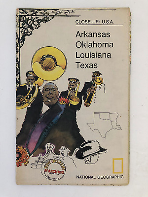
$5.49 Shipping Location: Georgetown, United States Template By Froo! National Geographic Map- 1974 Close-Up USA Oklahoma Texas Louisiana Arkansas National Geographic Map- 1974 Close-Up USA Oklahoma Texas ... moreLouisiana Arkansas Vintage 1974 two sided map Close-Up USA. Map shows Oklahoma, Louisiana, Arkansas, and Texas. The opposite side includes lots of historical information on the area by National Geographic Society. The map measures approx 35" x 23" in size. Never Unfolded. Shipping: All orders are carefully packaged. With a(Handle With Care Sticker) on the packaging. All orders ship the same or next business day. We ship orders Monday to Saturday. Orders placed before 2 pm(CST) on Fridays will ship on Saturday. We ship all orders via the United States Postal Service: First Class. Media Mail, Parcel Post, or Priority Mail, all include tracking numbers. Multi-Item Orders: We do combine shipping costs on multi-item orders. In order to receive the best shipping cost possible for your specific order please place your order. But before paying, request an invoice from us with combined shipping. We will return to you an adjusted invoice with the best shipping price for your order. Return Policy: Refunds given as money back or exchange(buyer’s choice) The buyer must pay return shipping. Please contact me within 14 days after receiving the item. Privacy Policy: Our company will never share your personal information in any way with an outside company. Our company will not send you unsolicited advertisements. Most reasonable offers are accepted. PayPal only. Please. Payment is expected within 2 days of auction end; immediate payment if you use Buy It Now. I will try and answer any questions. I am not an expert on anything I sell. And do my best to describe each item accurately. I buy many different items for the purpose of reselling them here on ebay. Any descriptions I give indicating the condition of item(s) such as: vintage. Antique, excellent, very good, good, and poor, or levels of functioning are purely subjective to what I observe, test and think of the item.
Buy It Now
$4.50 Shipping Location: Desoto, United States Vintage December 1929 National Geographic map! Has some wear from age and a few little rips but in good shape! I welcome any questions and as always happy ... morebidding!
Buy It Now
Free Shipping Location: Anaheim, United States Map Publisher: The National Geographic Society, Washington, District of Columbia, USA. Bio-predation & Oxidation (aging). THERE ARE HOLES ON THE FOLDS ... moreFROM BEING OPENED AND CLOSED. They are hard to see when laid flat.

Buy It Now
$13.20 Shipping Location: BECCLES, United Kingdom National Geographic map of the moon- very large- 28" x 50" great for classroom instruction on space Educational map published in February 1969. ... moreFeaturing detailed illustrations of both the near and far sides of the moon. This map also contains an abundance of illustrations and information about the moon including its physical properties and features, phases, eclipses, orbital paths, and the Apollo mission. Map features: Illustrations of the near and far sides of the moon including all the named features• The physical properties and features of the moon• Illustrations and information about the lunar month and the phases of the moon. Eclipses, libration, orbital paths, the tides, moon lore, and more• Information and illustrations about the Apollo mission• Moon comparisons and planet to satellite size ratio• Profile of a crater showing Copernicus. An average moon crater, in comparison to the Grand Canyon Map is in great shape. Many listings this week and we will combined shipping charges. Happy Looking! Posted with
Buy It Now
$9.35 Shipping Condition: Very Good Location: LEAMINGTON SPA, United Kingdom The National Geographic Society, Washington D.C. However, we are not experts.
Buy It Now
$17.91 Shipping Location: BECCLES, United Kingdom Format - Map.
Buy It Now
$4.50 Shipping Location: Desoto, United States This is a"Classical Lands of the Mediterranean" National Geographic folded map from December 1949 that is in fair to good condition. It measures ... moreapproximately 32 inches by 22 inches. It is intact with some minor wear and discoloration. This is my favorite of the 4 maps I have listed. Would look nice framed. S hipped first class mail within 24 hours of payment or on Monday if payment is on the weekend.

Buy It Now
$5.00 Shipping Location: Springfield, United States World War II Asia and the Pacific Map + Europe and North Africa National Geographic December 1991 This two-sided poster is in mint condition. It is 20" ... morex 27" 113 Click on the red book icon and check our Ebay store Heart for Ethiopia for more good buys. We have many books and other items. They are arranged in categories. Most are $1 or $2. All proceeds go to Ethiopia to provide for development and child education in rural Ethiopia. Because we are raising money for charity no item will ever be reduced below $1. We give a combined shipping discount on all media items. Shipping for each additional media item is only $1.50. 100% Satisfaction Guarantee Terms: Payment is due at end of auction. If payment is not received within 7 days it will be reported as unpaid and the item will be relisted. Combined shipping and handling is available on multiple purchases made within a week. Books cannot be combined with other items as they are sent by media mail. Shipping for books is calculated using the shipping cost of the heaviest book plus $1.50 for each additional book. Media mail takes 5 to 14 days. It includes tracking. If you are satisfied with your purchase. Please leave positive feedback. Good feedback will quickly be left for you when payment is received. Prioity mail is available for an additional fee. If there is a problem with your item. Please email before leaving feedback and give us a chance to correct the problem. Email us for international shipping costs. Customs may be charged on international shipments. All customs charges are the responsiblity of the buyer and are not included in the selling price. Feel free to email us if you have any questions or concerns. Powered by The free listing tool. List your items fast and easy and manage your active items. Powered by The free listing tool. List your items fast and easy and manage your active items. Powered by The free listing tool. List your items fast and easy and manage your active items. Powered by The free listing tool. List your items fast and easy an
Buy It Now
$7.00 Shipping Location: Deland, United States Vintage 1937 Modern Pilgrim's Map of the British Isles(the Kingdom of Great Britain and Northern Ireland and the Irish Free State) Prepared for the ... moreNational Geographic Society for National Geographic Magazine, Gilbert Grosvenor, Editor. Includes beautiful cameos of notable personalities from the various geographic areas. 36" x 29 1/2" Map is in very good pre-owned condition. As is typical of maps of this age. This map is fragile. g.RcmdId ViewItemDescV4,RlogId p4%60bo7%60jtb9%3Fuk%601d72f%2Bjw%60hquvg%3Eg-149c41ec260-0x103-
Buy It Now
$7.83 Shipping Location: Milwaukee, United States Explore the world with this beautiful National Geographic Atlas of the World, Revised Sixth Edition, published in 1995 by John Shupe. This original piece ... moreis in excellent shape and perfect for collectors or anyone looking to learn more about the world. The atlas features detailed world maps and includes information on the political and physical geography of each region. Whether you're a seasoned traveler or a student of geography, this Atlas is a must-have addition to your collection. The atlas comes in the format of a hardcover book and is perfect for displaying on a bookshelf or coffee table.
Buy It Now
$18.99 Shipping Location: Lynden, United States 1966 Vintage National Geographic Society World Globe Modernist RARE . Shipped with USPS Parcel Select Ground.
Buy It Now
$6.00 Shipping Location: Deland, United States Good condition.

Buy It Now
$5.49 Shipping Location: Georgetown, United States You are looking at a National Geographic Map Titled Precious Resource Water& The United States- November 1993. This Map is in good condition with ... morenormal wear. Their are two small tears in the middle of the map along the crease. The tears are small and do not take away from the functionality of the map. Map is from the Cartographic Division of the National Geographic Society. It is double sided and each picture represents one side. This map is a great educational tool and would be great in a classroom or for homeschooling. Item will be shipped in a bubble padded mailer. I have a lot of different maps for sale. Please look through my other auctions to find out all that I have for sale. Item is in Hand and Ready to ship. May even ship the same day. Comes from a pet free and smoke free home. Please ask all questions prior to bidding. I will answer them as quickly as possible. I Accept PayPal Only PAYMENT MUST be received with in 2 days of Winning the Auction. If payment is not received then an Unpaid Item Report will be opened and Auction will be re-listed Free First Class Shipping. Which includes tracking. Item usually ships within 24 hours after cleared payment is received. I will ship to the address provided to me through Pay Pal. I will ship to the Lower 48 States in the USA Only. Feedback: Your feedback is greatly appreciated. Thank you for your time. Powered by The free listing tool. List your items fast and easy and manage your active items.
Buy It Now
$5.62 Shipping Location: Mililani, United States Antique Map of the Western Theater of War 1918. 27" x 33" Folding Map.
Buy It Now
$5.30 Shipping Location: Holyoke, United States THIS IS A VINTAGE MAP OF AFRICA AND ADJOINING PORTIONS OF EUROPE AND ASIA. PUBLISHED IN 1922 BY THE NATIONAL GEOGRAPHIC MAGAZINE. MEASURES APPROX. 28 ... more1/2" BY 32" HAS A BIT OF WEAR AT SOME OF THE FOLD POINTS BUT EASILY TAPED, OVERALL INTACT AS SHOWN. LETTERING CRISP. NO RESERVE.
Buy It Now
$20.85 Shipping Location: Caledonia, United States NATIONAL GEOGRAPHIC. Laminated MAP of the MIDDLE EAST. Not Folded.
Buy It Now
$4.13 Shipping Location: Saint Clair, United States I inspected each of these and opened them up to look them over. There could arise a pin-hole upon further handling however.
Buy It Now
Free Shipping Location: Nampa, United States TODAY FOR SALE IS A CLASSIC 1954 MAP OF CALIFORNIA PUBLISHED BY NATIONAL GEOGRAPHIC SOCIETY. GREAT HISTORIC MAP IN GREAT CONDITION. WOULD LOOK GREAT FRAMED ... moreCHECK OUT THE PICTURES ASK QUESTIONS. SHIPS FIRST CLASS MAIL. THANK FOR VIEWING MY ITEM.
Buy It Now
Location: Deltona, United States This large vintage National Geographic world globe is a stunning addition to any antique or map collection. Measuring 38 inches in diameter, it features ... morea vintage original design with a blue color scheme and a rotating feature for easy viewing. The cartographer/publisher is William T. Peele, Chief Cartographer, and it dates back to 1976, making it a rare find for collectors. The globe is classified under the categories of Antiques, Maps, Atlases & Globes, and World & Celestial Globes. It's perfect for enthusiasts of vintage and historic items, or anyone looking to add a unique and timeless piece to their home decor.Please note compass glove topper missing, and some wear to globe
Buy It Now
$7.00 Shipping Location: Deland, United States Good shape.
Buy It Now
Free Shipping Location: Portland, United States This map has some wear at the corners and creases from being folded. I try to give as accurate of a description as I can and point out any flaws that ... moreI notice in an item. If I overlook something. Please bring it to my attention so I can address the issue. I want you to be happy with your purchase! I offer a generous shipping discount for multiple items.

Buy It Now
$78.79 Shipping Location: Menifee, United States Normal 0 MicrosoftInternetExplorer4 Here is a great globe that shows ocean depths and mountain heights in meters. Amazing ocean detail, no political boundaries ... morejust the physical geographical characteristics of the globe. There is a mounting hole at the North and South Poles so the globe can be mounted on the heavy duty base either way for observation. A very attractive globe in great condition. Copyright 1978 National Graphic Society Washington. D.C. Condition issues: Condition issues: Some small nicks from the globe. The North Pole plastic part has deteriorated from time& sitting in the sun. There may also be slight fading from the sun. See pics for details. POSITIVE FEEDBACK IS ALWAYS APPRECIATED AND PROMPTLY RETURNED! Check out my! BEFORE you“BUY IT NOW” PLEASE: Read my item description very carefully. Always feel free to ask any questions before buying. Look at the pictures carefully as they are part of the description. This item is currently being stored in a smoke free facility. If you need additional pictures. Please ask. We certainly don't mind sending more. Please email me through eBay with questions or if you need a specific picture. I am happy to reply to any requests. I think I can also now email pictures through eBay. We are not always the experts on all the items that we sell however. We do try to make every effort to review the condition of each item and report to you what we see. Items are being sold as is. Payment is required immediately with purchase. However, other arrangements can be made such as paying within 3 days of purchase if we are contacted first. All items are shipped via USPS. UPS, or FEDEX to the lower 48 states. All customers will be issued a tracking number or USPS Delivery Confirmation number upon shipment. Most of our orders ship within 1 business day after payment has cleared. We are not responsible for carrier transit time. We do not ship during weekends or holidays. If you live somewhere else other than the lower 48 United States, we are sorry, but it may cos
Buy It Now
$4.43 Shipping Location: Winter Haven, United States

Buy It Now
$3.15 Shipping Location: Portland, United States Vintage 1992 National Geographic Poster& Map of Amazonia(d) This double sided poster is in excellent condition. It has a informational Poster of Amazonia ... moreon one side and a full color map of the region on the other side. It measures approximately 28 x 20 inches in size. Please be aware that these National Geographic Maps are anywhere from 30 to 80 years old. They are printed on paper that is not acid free and in most cases have not been stored in the best way. So the maps you are buying will be in a condition that reflects both of these facts. The map you get may be worn or lightly torn along the fold lines due to the acidity of the paper and being folded for years. They may also be discolored or mottling spots again due to the acidity of the paper. The borders of the maps may also have small tears. On occasion maps may smell musty from the way they have been stored in the past. When the map is kept in an open area the musty smell will fade away in time. Any damage that is above and beyond the norm will be disclosed. Payment through Paypal only. Payment is required within four days. I do combine multiple purchases for shipping. If you have bought an item and are going to bid on a future item you must let me know if you want them shipped together. DON'T PANIC IF MY SHIPPING CHARGES SEEM HIGH! I sometimes just charge a higher amount because I am not sure of the package size however no profit is made on shipping and handling charges unless any special circumstances are involved. Any overcharge over $1.00(one dollar) will be refunded. If you feel you are owed a refund please let me know. Items are sold in"as in" condition. Should you have any problem with the item or you feel that it has been misrepresented. Please contact me so that we can reach a mutually satisfactory solution. Sorry but no overseas bidding without contacting me first. If your feedback score is less than 20 then please contact me before bidding.
Free Shipping Location: Seven Valleys, United States Some wear. FREE LOCAL DELIVERY ON SALES TOTALING $15 OR MORE IN ST. JOHN'S/MOUNT PEARL AREA. ITEMS WILL BE DROPPED IN YOUR MAILBOX WITHIN 48 HOURS ... moreOF RECEIVING PAYMENT. BUYERS FROM AREAS CLOSE BY SHOULD CONTACT ME. I MAY BE ABLE TO OFFER FREE DELIVERY TO YOUR AREA. I only sell older used items. I accept PAYPAL. Feel free to contact me. I DO COMBINE S/H FOR MULTIPLE ITEMS. YOU WILL HAVE TO WAIT FOR or request MY INVOICE(not the end of auction email from ebay) TO GET THE LOWEST SHIPPING COST WHEN BUYING MULTIPLE ITEMS. Item Location: Maps Box 1. Item# 54:RcmdId ViewItemDescV4,RlogId p4%60bo7%60jtb9%3Fuk.rp73%28e013%3F%3E%3A-14346b7bf4c-0xec-
Buy It Now
$3.65 Shipping Location: Portland, United States
Buy It Now
$4.50 Shipping Location: Desoto, United States United States and adjoining portions of Canada and Mexico Map May 1933 This large one-sided poster is in good condition with no marks or tears. Some folds ... morehave been taped for reinforcement. It is an original map that was in a National Geographic magazine. It is 27" x 40". 224.
Buy It Now
$5.49 Shipping Location: Georgetown, United States North Dakota South Dakota Nebraska Kansas Minnesota Iowa Missouri Map.
Buy It Now
$4.55 Shipping Location: Ithaca, United States NATIONAL GEOGRAPHIC SOCIETY MAP THE REACHES OF NEW YORK CITY APRIL 1939 VINTAGE Vintage National Geographic Scociety map The Reaches Of New York City ... morecirca April 1939. Measures 26 1/2 X 29 inches in size when fully opened(68 X 74cm) Map is an authentic original in good condition as shown in photos. 006.RcmdId ViewItemDescV4,RlogId p4%60bo7%60jtb9%3Fuk%600d72f%2B%3E006-14a19df28a3-0x105-
Buy It Now
$3.65 Shipping Location: Portland, United States The map is in great condition.
3d 9h 56m 13s 0 bids
$3.95 Now
$2.59 Shipping Location: Salisbury, United States VINTAGE Italy map National Geographic Magazine- Atlas Plate 37 November 1961. FREE US SHIPPING! Will ship worldwide! Please check with me on costs of ... moreshipping outside of the US. Descriptions are to the best of my ability. However. I am not a collector so may not know the best way to describe the item. Please feel free to E-mail me with questions or for more pictures and check out my other auction items.
Buy It Now
$5.98 Shipping Location: Los Angeles, United States National Geographic Society - Printed in 2009 - Folded. The Indochina Peninsula seems to pour from the cast-ern bend of the Himalaya. Southeast Asia Map ... more- Large Size 20 in wide X 31 in. Northeast of Khone Falls, the fertile Bolovens Plateau is an isolated extrusion of basaltic lava.
Buy It Now
$4.99 Shipping Location: Rock Creek, United States 1937 NATIONAL GEOGRAPHIC MAP OF SOUTH AMERICA. FOLDED.
Buy It Now
$5.49 Shipping Location: Georgetown, United States The Making of Alaska Map 1983, Map only.
Buy It Now
$6.05 Shipping Location: Merlin, United States This map, originally published by National Geographic Magazine, showcases the United Kingdom with detailed information about England and Ireland. The ... moremap has been well-preserved and is in good condition for its age.
Buy It Now
$5.95 Shipping Location: Newbern, United States
Buy It Now
$3.15 Shipping Location: Portland, United States Description: MAP of SOUTHERN AFRICA by National Geographic Society Date: Nov 1962 Size: 19 x 25 inches Condition: very good condition
Buy It Now
$6.05 Shipping Location: Moravia, United States
Buy It Now
$7.00 Shipping Location: Deland, United States Map by A. Hoen & Co (Baltimore).
Buy It Now
$4.15 Shipping Location: Powder Springs, United States This detailed and informative map is the perfect tool for any traveler looking to explore the city.
|
|
|
In
|
NATIONAL GEOGRAPHIC WALL MAP 1986 MAKING OF AMERICA PACIFIC NORTHWEST HISTORY
NATIONAL GEOGRAPHIC WALL MAP AUGUST 1986 MAKING OF AMERICA PACIFIC NORTHWEST HISTORY INFO TOO. FREE SHIPPING. EACH ADDITIONAL NATIONAL GEOGRAPHIC MAP/INSERT IS*FREE SHIPPING* NO INTERNATIONAL SHIPPING. US SHIPPING ONLY. PLEASE NO PERSONAL CHECKS. PLEASE EMAIL WITH ANY QUESTIONS! Powered by The free listing tool. List your items fast and easy and manage your active items.
|
|
|
VINTAGE NATIONAL GEOGRAPHIC MAP OF NORTH AMERICA APRIL 1964
FOR YOUR CONSIDERATION IS AN APRIL 1964 NATIONAL GEOGRAPHIC MAP OF NORTH AMERICA. IT IS IN VERY GOOD CONDITION AND DOES NOT HAVE ANY TEARS. RIPS, ETC. INTERNATIONAL BIDDERS ARE WELCOME. I WILL SHIP WORLDWIDE. IF YOU HAVE ANY QUESTIONS PLEASE E-MAIL ME. WHEN POSSIBLE I AM HAPPY TO COMBINE SHIPPING TO SAVE ON COSTS. Powered by The free listing tool. List your items fast and easy and manage your active items.
|
|
|
Vintage USA Road Map - National Geographic - 1961 - United States of America
Vintage Map of the USA from 1961 The map was originally created and distributed by National Geographic and is truly an incredible piece. Size: 19 x 25 inches Map in great shape. Would look great framed. Many listings this week and we will combined shipping charges. Happy Looking!
|
|
|
National Geographic MAP October 1996 USA United States
Description: Double-sided MAP/Supplement by National Geographic Society FEDERAL LANDS in the Fifty States/ UNITED STATES The Physical Landscape Date: Oct 1996 Size: 20.5 x 31.50 inches Condition: very good condition Magazine is not included. Please check out my store for its availability Serious Bidder Only Please. Ask question if any. Shipping: USA: $2.50 first class or $5.50 Priority Mail within the lower 48 states. For each additional map. Add $1 Free shipping with purchased of any magazine. Canada: $3.99 airmail letter post or $13.99 global priority For each additional map. Add $1 Free shipping with purchased of any magazine. International: $5.99 airmail letter post or $17.99 global priority mail For each additional map add $1 Free shipping with purchased of any magazine. Payment: Payment is due within 7 days. Please contact me within ... more3 days to arrange payment if you do not pay instantly by Paypal Return: I do not except return unless I send the wrong item(s) or item(s) that are not as described. Item(s) returned must be in the same condition it was sent. Refund will cover the bid amount but not shipping.
|
|
|
National Geographic Map - Native American Heritage A Visitors Guide - Two Sided
You are looking at a National Geographic Map Titled Native American Heritage- October 1991. This Map is in excellent condition and is from the Cartographic Division of the National Geographic Society. It is double sided and each picture represents one side. This map is a great educational tool and would be great in a classroom or for homeschooling. Item will be shipped in a bubble padded mailer. I have a lot of different maps for sale. Please look through my other auctions to find out all that I have for sale. Item is in Hand and Ready to ship. May even ship the same day. Comes from a pet free and smoke free home. Please ask all questions prior to bidding. I will answer them as quickly as possible. I Accept PayPal Only PAYMENT MUST be received with in 2 days of Winning the Auction. If payment is not received then an Unpaid Item Report will ... morebe opened and Auction will be re-listed Free First Class Shipping. Which includes tracking. Item usually ships within 24 hours after cleared payment is received. I will ship to the address provided to me through Pay Pal. I will ship to the Lower 48 States in the USA Only. Feedback: Your feedback is greatly appreciated. Thank you for your time. Powered by The free listing tool. List your items fast and easy and manage your active items.
|
|
|
1978 National Geographic Society CLOSE-UP USA Map Set 16 Maps Plus Book & Case
COMPLETE SET: 15 regional maps 1 map of USA 1 map of Grand Canyon 1 index book 1 distance overlay 1 hard case All are like new and some maps have never been unfolded. Weighs approximately 4 pounds.
|
|
|
NATIONAL GEOGRAPHIC VINTAGE MAP NORTHWESTERN AFRICA 1966 SUDAN GUINEA LIBYA MALI
NATIONAL GEOGRAPHIC VINTAGE MAP NORTHWESTERN AFRICA 1966 SUDAN GUINEA LIBYA MALI. GOOD CONDITION! FREE SHIPPING. EACH ADDITIONAL NATIONAL GEOGRAPHIC MAP/INSERT IS*FREE SHIPPING* NO INTERNATIONAL SHIPPING. US SHIPPING ONLY. PLEASE NO PERSONAL CHECKS. PLEASE EMAIL WITH ANY QUESTIONS! Powered by The free listing tool. List your items fast and easy and manage your active items.
|
|
|
1985 National Geographic Atlas Of North America Space Age~264 Pages~VGC
1985 National Geographic Atlas Of North America Space Age~264 Pages~VGC This is a 1985 National Geographic Atlas Of North America Space Age Portrait Of A Continent. It is large measuring 12 1/2" x19" and has 264 pages. This is not your average atlas. The cover is thick and all the pages are in great condition.With just a few scuffs on the cover. Always happy to combine shipping If you have any questions just email me.We have a smokefree home but are owned by the cats! WE ACCEPT PAYPAL ONLY. Thanks for looking! We accept Paypal only. Payment is due within 3 days. Always happy to combine shipping. We ship on Monday.Wednesday and Friday. We will be happy to ship sooner if you need something right away.We do ship internationally and love our Canadian buyers. Please email for a quote before purchase. We love going to estate sales! Most ... moreeverything we list is from estate sales and garage sales. If there is something you are looking for just let us know! We have a smoke-free home but we do have cats. The Wee Family(Mama and her two babies Dixie and Trixie)and our 11 year old Sadie.We try our best to keep them away from the linens but we do find Sadie asleep on them occasionally. If you have any questions please email. We always answer quickly.
|
|
|
National Geographic Society Map - North America Before Columbus 1972
Payment is due within 3 days of purchase.
|
|
|
South Central United States Map - 1961 - National Geographic - Texas Oklahoma +
Up for auction is a National Geographic Society Map as follows: February 1961- South Central United States- Measures approximately 24 1/2 x 19 inches- One side is a map of the region- Reverse side is blank- Map is in good vintage condition with a little separation at the ends of the main fold as pictured- Map will be shipped folded and protected We like to keep it simple. We respond to emails and ship as fast as we can. We will combine and/or alter shipping when it makes sense to do so. We are experts at nothing but we do welcome questions and guarantee satisfaction. And. As always, Thank You! Powered by The free listing tool. List your items fast and easy and manage your active items. RcmdId ViewItemDescV4,RlogId p4%60bo7%60jtb9%3Fv%7F.rpn31%3E-13d469ae05b-0x104-
|
|
|
VINTAGE NATIONAL GEOGRAPHIC MAP OF HAWAII JULY 1960
FOR YOUR CONSIDERATION IS A JULY 1960 NATIONAL GEOGRAPHIC MAP OF HAWAII. IT IS IN VERY GOOD CONDITION AND DOES NOT HAVE ANY TEARS. RIPS, ETC. INTERNATIONAL BIDDERS ARE WELCOME. I WILL SHIP WORLDWIDE. IF YOU HAVE ANY QUESTIONS PLEASE E-MAIL ME. WHEN POSSIBLE I AM HAPPY TO COMBINE SHIPPING TO SAVE ON COSTS. Powered by The free listing tool. List your items fast and easy and manage your active items.
|
|
|
Vintage 1968 National Geographic Map of The United States (e)
Vintage 1968 National Geographic Map of The United States(e) The map is in excellent condition. It measures approximately 42 x 30 inches in size. Please be aware that these National Geographic Maps are anywhere from 30 to 80 years old. They are printed on paper that is not acid free and in most cases have not been stored in the best way. So the maps you are buying will be in a condition that reflects both of these facts. The map you get may be worn or lightly torn along the fold lines due to the acidity of the paper and being folded for years. They may also be discolored or mottling spots again due to the acidity of the paper. The borders of the maps may also have small tears. On occasion maps may smell musty from the way they have been stored in the past. When the map is kept in an open area the musty smell will fade away in time. Any damage ... morethat is above and beyond the norm will be disclosed. Payment through Paypal only. Payment is required within four days. I do combine multiple purchases for shipping. If you have bought an item and are going to bid on a future item you must let me know if you want them shipped together. DON'T PANIC IF MY SHIPPING CHARGES SEEM HIGH! I sometimes just charge a higher amount because I am not sure of the package size however no profit is made on shipping and handling charges unless any special circumstances are involved. Any overcharge over $1.00(one dollar) will be refunded. If you feel you are owed a refund please let me know. Items are sold in"as in" condition. Should you have any problem with the item or you feel that it has been misrepresented. Please contact me so that we can reach a mutually satisfactory solution. Sorry but no overseas bidding without contacting me first. If your feedback score is less than 20 then please contact me before bidding.
|
|
|
Vintage 1958 National Geographic Map of Southeastern United States (c)
Vintage National Geographic Map Southeastern United States(c) The map is in excellent condition. It measures approximately 42 x 30 inches in size. Please be aware that these National Geographic Maps are anywhere from 30 to 80 years old. They are printed on paper that is not acid free and in most cases have not been stored in the best way. So the maps you are buying will be in a condition that reflects both of these facts. The map you get may be worn or lightly torn along the fold lines due to the acidity of the paper and being folded for years. They may also be discolored or mottling spots again due to the acidity of the paper. The borders of the maps may also have small tears. On occasion maps may smell musty from the way they have been stored in the past. When the map is kept in an open area the musty smell will fade away in time. Any damage ... morethat is above and beyond the norm will be disclosed. Payment through Paypal only. Payment is required within four days. I do combine multiple purchases for shipping. If you have bought an item and are going to bid on a future item you must let me know if you want them shipped together. DON'T PANIC IF MY SHIPPING CHARGES SEEM HIGH! I sometimes just charge a higher amount because I am not sure of the package size however no profit is made on shipping and handling charges unless any special circumstances are involved. Any overcharge over $1.00(one dollar) will be refunded. If you feel you are owed a refund please let me know. Items are sold in"as in" condition. Should you have any problem with the item or you feel that it has been misrepresented. Please contact me so that we can reach a mutually satisfactory solution. Sorry but no overseas bidding without contacting me first. If your feedback score is less than 20 then please contact me before bidding.
|
|
|
Vintage 1947 National Geographic Map of South Central United States (c)
Vintage 1947 National Geographic Map of South Central United States(c) The map is in excellent condition and measures approximately 28 x 24 inches in size. Payment through Paypal only. Payment is required within four days. I do combine multiple purchases for shipping. If you have bought an item and are going to bid on a future item you must let me know if you want them shipped together. Items are sold in"as in" condition. Should you have any problem with the item or you feel that it has been misrepresented. Please contact me so that we can reach a mutually satisfactory solution. Sorry but no overseas bidding without contacting me first. If your feedback score is less than 20 then please contact me before bidding.
|
|
|
1991 Native American Heritage A Visitors Guide US Map National Geographic Geo
Native American Heritage 1991. Used Map approx: 29" x 20.50"
|
|
|
National Geographic Map Insert July 1998 Natural Hazards of North America
National Geographic Map Insert July 1998 Natural Hazards of North America PLEASE NOTE: We are a pet household. We are a smoking household. One side is Great Disasters: Nature in Full Force& the other other side is Natural Hazards of North America. I also have 4 other National Geographic inserts up for bid. If interested. ° Size: 31 1/4" x 20 1/4" ° Condition: Mint. Items are always shipped insured for any winning bids over $25 See all shipping details above. International bidders(except Canada) If really interested, please e-mail for a shipping quote. ~ Combined shipping with other auctions is always available. ~ Pick up in Northeast Philly(Zipcode 19111. Near Cottman& Castor) is always an option as a Cash preferred(PayPal accepted) transaction with no handling charge. Other Miscellaneous Information ° Please ... moreallow 24 hours for me to respond to any e-mail questions; I cannot otherwise guarantee a timely response. ° A Handling Fee of $1.50 is added to the Actual Postage of the item. Delivery Confirmation is included in the $1.50 Handling Fee. If I have overcalculated the shipping by $1 or more. I will refund that amount to you. °I do NOT do"Buy It Now" Please do not ask. ° Please note that this is an auction and that there are no returns unless the item has been grossly misrepresented. Only the winning bid will be refunded. Not the postage. I try and describe all items to the best of my ability; nonetheless, it is possible I may overlook a tiny flaw or two. °Please note that due to so many bidders not posting feedback to buyers. I will only post positive feedback for you after you have received the item, are satisfied and have posted my feedback. Before posting negative feedback. Please give me a chance to resolve the issue. Thank you! ° Your item(s) are normally shipped within 3 days of receipt of payment. However. I am out of town for a few days every 2 weeks or so and your item(s) may be delayed in shipping. You will be notified by e-mail if th
|
|
|
Vintage/Antique 1933 National Geographic United States Map
Today you are checking out a vintage 1933 National Geographic United States Map. Overall it is in good condition. But does have some issues/character as you can see in the photographs. Check out all the photographs for further information! An AWESOME item for any collector to get framed, etc. This map measures 26 1/2" x 40" OUP on eBay only accepts PayPal on all of its items. And Delivery Confirmation is included with EVERY order! PayPal payment is due within two days of winning an auction, an accepted Best Offer, or purchase of any Buy-It-Now item in OUP on eBay. PLEASE follow us on Facebook for EXCLUSIVE NEWS and more! http:facebook.com/OUnitProductions If you have ANY questions. Comments, or ANYTHING ELSE. PLEASE contact us TODAY! THANK YOU SO MUCH!
|
|
|
National Geographic Close-Up USA - 5 Maps- 1975 & 1976
National Geographic Close-Up USA- 5 Maps- 1975& 1976 I am selling 5 Close-Up U.S.A. National Geographic Double Sided Maps. The Close-Up U.S.A. Map of: 1) Maryland. Virginia, Delaware, West Virginia is dated 1976 The following other 4 maps are dated 1975(2) New Hampshire. Vermont, Massachusetts, Rhode Island, Connecticut(3) Alaska(4) Maine with the Maritime Provinces of Canada(5) Tennessee. North Carolina, South Carolina, Georgia, Alabama, Mississippi from a pet and smoke free environment The maps haven't been used. Just stored in a drawer Payment via paypal only using U.S. Funding Sources I only ship within the U.S.
|
|
|
Original National Geographic MAP - 1st Photo Ever Made Division Tropos/Stratosph
Original Supplement to the National Geographic Magazine from 1936.of the First Photograph ever made showing the Division Between the Troposphere and the Stratosphere and also the Actual Curvature of the Earth-Photographed from an Elevation of 72.395 feet, the Highest Point ever Reached by Man.Photograph by Captain Albert W. Stevens. Very good condition.one sided.Measures approximately 24" x 17" I have several of these maps from the 30's. 40's, 50's and 60's that I picked up at an auction many years ago. I'd be interested in selling them all as a lot. If you're interested, please ask any questions. I will combine shipping. Thanks for looking.
|
|
|
SOUTHWESTERN U.S MAP 1948 THE NATIONAL GEOGRAPHIC MAGAZINE, GILVERT GROSVENOR
FOR SALE 1948 SOUTHWESTERN U.S. MAP IT IS NOT PRINTED ON PAPER. IT IS PRINTED ON CLOTH LIKE MATERIAL MAP IS 25" x 35-1/2" NO TEARS. HOLES, STAINS OR THINGS LIKE THAT
|
|
|
SOUTH CENTRAL U.S MAP 1947 THE NATIONAL GEOGRAPHIC MAGAZINE, GILVERT GROSVENOR
FOR SALE 1947 SOUTH CENTRAL U.S. MAP IT IS NOT PRINTED ON PAPER. IT IS PRINTED ON CLOTH LIKE MATERIAL MAP IS 25" x 31" NO TEARS. HOLES, STAINS OR THINGS LIKE THAT
|
|
|
NORTHWESTERN U.S MAP 1950 THE NATIONAL GEOGRAPHIC MAGAZINE, GILVERT GROSVENOR
FOR SALE 1950 NORTHWESTERN U.S. MAP IT IS NOT PRINTED ON PAPER. IT IS PRINTED ON CLOTH LIKE MATERIAL MAP IS 26-1/2" x 37-1/2" NO TEARS. HOLES, STAINS OR THINGS LIKE THAT
|
|
|
NORTH CENTRAL U.S MAP 1948 THE NATIONAL GEOGRAPHIC MAGAZINE, GILVERT GROSVENOR
FOR SALE 1948 NORTH CENTRAL U.S. MAP IT IS NOT PRINTED ON PAPER. IT IS PRINTED ON CLOTH LIKE MATERIAL MAP IS 27-1/2" x 28-1/2" NO TEARS. HOLES, STAINS OR THINGS LIKE THAT
|
|
|
SOUTHEASTERN U.S MAP 1947 THE NATIONAL GEOGRAPHIC MAGAZINE, GILVERT GROSVENOR
FOR SALE 1947 SOUTHEASTERN U.S. MAP IT IS NOT PRINTED ON PAPER. IT IS PRINTED ON CLOTH LIKE MATERIAL MAP IS 27-1/2" x 32-1/2" NO TEARS. HOLES, STAINS OR THINGS LIKE THAT
|
|
|
NORTHEASTERN U.S MAP 1945 THE NATIONAL GEOGRAPHIC MAGAZINE, GILVERT GROSVENOR
FOR SALE 1945 NORTHEASTERN U.S. MAP IT IS NOT PRINTED ON PAPER. IT IS PRINTED ON CLOTH LIKE MATERIAL MAP IS 27-1/2" x 40-1/2" NO TEARS. HOLES, STAINS OR THINGS LIKE THAT
|
|
|
UNITED STATES June 1951 TNE NATIONAL GEOGRAPHIC MAGAZINE, GILVERT GROSVENOR
FOR SALE 1951 UNITED STATES MAP IT IS NOT PRINTED ON PAPER. CLOTH LIKE MATERIAL MAP IS 27-1/2" x 41" NO TEARS. HOLES, STAINS OR THINGS LIKE THAT
|
|
|
National Geographic SPECIAL MAP 1992 Battlefields of the CIVIL WAR
Description: Double-sided MAP of Battlefields of the CIVIL WAR by National Geographic Society Date: Copyright 1974. Reprinted 1992 especially for The Blue and The Gray Size: 29 x 22 inches Condition: I see a very small tear in the folding corner. Still in very good condition, see photos below Magazine is not included. Please check out my store for its availability Serious Bidder Only Please. Ask question if any Shipping: USA: $2.50 first class or $5.50 Priority Mail within the lower 48 states. For each additional map. Add $1 Free shipping up to 5 maps for every magazine purchased Canada: $3.99 airmail letter post or $13.99 global priority For each additional map. Add $1 Free shipping up to 5 maps for every magazine purchased International: $5.99 airmail letter post or $17.99 global priority For each additional map. Add $1 Free shipping up ... moreto 5 maps for every magazine purchased Payment: Payment is due within 7 days. Please contact me within 3 days to arrange payment if you do not pay instantly by Paypal. Return: I do not except return unless I send the wrong item(s) or item(s) that are not as described. Item(s) returned must be in the same condition it was sent. Refund will cover the bid amount but not shipping.
|
|
|
Map - North American Indian National Geographic 2004 w272
~ ~ SHIPMENT Powered by Powered by The free listing tool. List your items fast and easy and manage your active items.
|
|
|
UNITED STATES WALL MAP + FEDERAL LANDS National Geographic September 1982 HUGE
United States Map + America's Federal Lands National Geographic September 1982 This huge two-sided poster is in mint condition. It is 28" x 42" 313 Click on the red book icon and check our Ebay store Heart for Ethiopia for more good buys. We have many books and other items. They are arranged in categories. Most are $1 or $2. All proceeds go to Ethiopia to provide for development and child education in rural Ethiopia. Because we are raising money for charity no item will ever be reduced below $1. We give a combined shipping discount on all media items. Shipping for each additional media item is only $1.50. 100% Satisfaction Guarantee Terms: Payment is due at end of auction. If payment is not received within 7 days it will be reported as unpaid and the item will be relisted. Combined shipping and handling is available on multiple ... morepurchases made within a week. Books cannot be combined with other items as they are sent by media mail. Shipping for books is calculated using the shipping cost of the heaviest book plus $1.50 for each additional book. Media mail takes 5 to 14 days. It includes tracking. If you are satisfied with your purchase. Please leave positive feedback. Good feedback will quickly be left for you when payment is received. Prioity mail is available for an additional fee. If there is a problem with your item. Please email before leaving feedback and give us a chance to correct the problem. Email us for international shipping costs. Customs may be charged on international shipments. All customs charges are the responsiblity of the buyer and are not included in the selling price. Feel free to email us if you have any questions or concerns. Powered by The free listing tool. List your items fast and easy and manage your active items. Powered by The free listing tool. List your items fast and easy and manage your active items. Powered by The free listing tool. List your items fast and easy and manage your active items. Powered by The free listing tool. List your items fast and easy and manage y
|
|
|
National Geographic MAP United States RIVERS July 1977
Description: Double-sided MAP of UNITED STATES WILD and SCENIC RIVERS by National Geographic Society Date: July 1977 Size: 17 1/2 x 24 1/2 Condition: good/vg condition Magazine is not included. Please check out my store for its availability Serious Bidder Only Please. Ask question if any. Shipping: USA: $2.50 first class or $5.50 Priority Mail within the lower 48 states. For each additional map. Add $1 Free shipping with purchased of any magazine. Canada: $3.99 firstl class or $13.99 priority For each additional map. Add $1 Free shipping with purchased of any magazine. International: $5.99 first class or $17.99 priority mail For each additional map add $1 Free shipping with purchased of any magazine. Payment: Payment is due within 7 days. Please contact me within 3 days to arrange payment if you do not pay instantly by Paypal. Return: I do ... morenot except return unless I send the wrong item(s) or item(s) that are not as described. Item(s) returned must be in the same condition it was sent. Refund will cover the bid amount but not shipping.
|
|
|
1946 JULY NATIONAL GEOGRAPHIC MAP THE UNITED STATES OF AMERICA
UP FOR SALE 1946 JULY NATIONAL GEOGRAPHIC MAP THE UNITED STATES OF AMERICA MAP IS IN GOOD CONDITION Powered by The free listing tool. List your items fast and easy and manage your active items. 5=2.RcmdId ViewItemDescV4,RlogId p4%60bo7%60jtb9%3Fvo%7B2d71f%2B%3E5%3D2-13db439e591-0xfd-
|
|
|
HUGE VINTAGE THE UNITED STATES MAP National Geographic February 1968 MINT
The United States Map National Geographic February 1968 This poster is in mint condition. It has slight edge wear. It is 29" x 43" 313 Click on the red book icon and check our Ebay store Heart for Ethiopia for more good buys. We have many books and other items. They are arranged in categories. Most are $1 or $2. All proceeds go to Ethiopia to provide for development and child education in rural Ethiopia. Because we are raising money for charity no item will ever be reduced below $1. We give a combined shipping discount on all media items. Shipping for each additional media item is only $1.50. 100% Satisfaction Guarantee Terms: Payment is due at end of auction. If payment is not received within 7 days it will be reported as unpaid and the item will be relisted. Combined shipping and handling is available on multiple purchases made ... morewithin a week. Books cannot be combined with other items as they are sent by media mail. Shipping for books is calculated using the shipping cost of the heaviest book plus $1.50 for each additional book. Media mail takes 5 to 14 days. It includes tracking. If you are satisfied with your purchase. Please leave positive feedback. Good feedback will quickly be left for you when payment is received. Prioity mail is available for an additional fee. If there is a problem with your item. Please email before leaving feedback and give us a chance to correct the problem. Email us for international shipping costs. Customs may be charged on international shipments. All customs charges are the responsiblity of the buyer and are not included in the selling price. Feel free to email us if you have any questions or concerns. Powered by The free listing tool. List your items fast and easy and manage your active items. Powered by The free listing tool. List your items fast and easy and manage your active items. Powered by The free listing tool. List your items fast and easy and manage your active items. Powered by The free listing tool. List your items fast and easy and manage your active items.
|
|
|
National Geographic MAP Supplement of National Parks United States MAY 1958
Description: Double-sided MAP of NATIONAL PARKS Monuments and Shrines of The United States and Canada by National Geographic Society Date: 1958 May Supplement Size: 19 x 24 3/4 inches Condition: good condition Magazine is not included. Please check out my store for its availability Serious Bidder Only Please. Ask question if any Shipping: USA: $2.50 first class or $5.50 Priority Mail within the lower 48 states. For each additional map. Add $1 Free shipping up to 5 maps for every magazine purchased Canada: $3.99 airmail letter post or $13.99 global priority For each additional map. Add $1 Free shipping up to 5 maps for every magazine purchased International: $5.99 airmail letter post or $17.99 global priority For each additional map. Add $1 Free shipping up to 5 maps for every magazine purchased Payment: Payment is due within 7 days. Please ... morecontact me within 3 days to arrange payment if you do not pay instantly by Paypal. Return: I do not except return unless I send the wrong item(s) or item(s) that are not as described. Item(s) returned must be in the same condition it was sent. Refund will cover the bid amount but not shipping. RcmdId ViewItemDescV4,RlogId p4%60bo7%60jtb9%3Fuk.rp73%28e013%3F%3E%3A-13dc36ac595-0xfa-
|
|
|
National Geographic MAP NATIVE AMERICAN HERITAGE 1991 october United States USA
Description: Double sided MAP/Supplement of NATIVE AMERICAN HERITAGE by National Geographic Society Date: October 1991 Supplement Condition: very good condition Size: 20 x 29 inches. Magazine is not included. Please check out my store for its availability Serious Bidder Only Please. Ask question if any. Shipping: Buyers must agree to the shipping charges below before bidding) USA: $2.50 first class or $5.50 Priority Mail within the lower 48 states. For each additional map. Add $1 Free shipping with purchase of any magazine. Canada: $3.99 airmail letter post or $13.99 global priority For each additional map. Add $1 Free shipping with purchase of any magazine. International: $5.99 airmail letter post or $17.99 global priority mail For each additional map add $1 Free shipping with purchase of any magazine. Payment: Payment is due within 7 days. ... morePlease contact me within 3 days to arrange payment if you do not pay instantly by Paypal Return: I do not except return unless I send the wrong item(s) or item(s) that are not as described. Item(s) returned must be in the same condition it was sent. Refund will cover the bid amount but not shipping.
|
|
|
National Geographic Society Close Up USA Book Maps W/Case 1988'' Good Condition
UP FOR SALE IS A NATIONAL GEOGRAPHIC CLOSE UP U.S.A. MAP SET. IT'S COMPLETE WITH ALL 15 COLORFUL PICTORIAL MAPS OF THE ENTIRE UNITED STATES. PLUS A LARGE MAP OF THE U.S.A SIZE IS 42' X 29' IT COMES WITH A GUIDE BOOK AND CASE. THE MAP PAPER FEELS LIKE VINYL. VERY STRONG. IN GOOD CONDITION. EMAIL ANY QUESTIONS. THANKS FOR LOOKING.
|
|
|
National Geographic WALL MAP NOVEMBER 1993 United States, USA, Water Resource
Description: Double sided MAP of The United States/ Precious Resources WATER by National Geographic Society Date: November 1993 Supplement Size: 42 3/4 x 29 3/4 inches Condition: very good condition Magazine is not included. Please check out my store for its availability Serious Bidder Only Please. Ask question if any. Shipping: USA: $2.75 first class or $5.50 Priority Mail For each additional map. Add $1 Free shipping with purchased of any magazine. Canada: $3.99 firstl class For each additional map. Add $1 Free shipping with purchased of any magazine. International: $5.99 first class For each additional map add $1 Free shipping with purchased of any magazine. Payment: Payment is due within 7 days. Please contact me within 3 days to arrange payment if you do not pay instantly by Paypal Return: I do not except return unless I send the wrong ... moreitem(s) or item(s) that are not as described. Item(s) returned must be in the same condition it was sent. Refund will cover the bid amount but not shipping.
|
|
|
National Geographic Map Battles of the CIVIL WAR APRIL 2005 Supplement Poster
Description: MAP/Supplement of Battles of The CIVIL WAR/ A National Transformed by CIVIL WAR by National Geographic Society Date: APRIL 2005 Supplement Size: 20 x 21 inches. Condition: very good condition Magazine is not included. Please check out my store for its availability Serious Bidder Only Please. Ask question if any. Shipping: Buyers must agree to the shipping charges below before bidding USA: $2.50 first class or $5.50 Priority Mail within the lower 48 states. For each additional map. Add $1 Free shipping with purchased of any magazine. Canada: $3.99 first class mail or $13.99 priority mail For each additional map. Add $1 Free shipping with purchase of any magazine. International: $5.99 first class mail or $17.99 priority mail For each additional map add $1 Free shipping with purchased of any magazine. Payment: Payment is due within ... more7 days. Please contact me within 3 days to arrange payment if you do not pay instantly by Paypal. Return: I do not except return unless I send the wrong item(s) or item(s) that are not as described. Item(s) returned must be in the same condition it was sent. Refund will cover the bid amount but not shipping. Double-sided map. Magazine is NOT included. Just to show the size of the map
|
|
|
1966 National Geographic Southern California Atlas Map Plate 69
1966 National Geographic Southern California Atlas Map Plate 69 Fits into the National Geographic Magazine Atlas Folio. I also have the 1958 Folio Book available as well as the following plates 2.5,6,11,12,18,25,32,3537,45,51,54, contact me if interested 7.RcmdId ViewItemDescV4,RlogId p4%60bo7%60jtb9%3Fuk%601d72f%2Bkw5%7Fos1%3E%3E7-13e83474063-0xf5-
|
|
|
Vintage 1976 National Geographic Double-sided Map of Portrait USA
Vintage 1976 National Geographic Double-sided Map of Portrait USA This map is in excellent condition. It is approximately 42 x 29 inches in size. Please be aware that these National Geographic Maps are anyware from 30 to 80 years old. They are printed on paper that is not acid free and in most cases have not been stored in the best way. So some of the maps you are buying will be in a condition that reflects both of these facts. The map you get may be worn or lightly torn along the fold lines due to the acidity of the paper and being folded for years. They may also be discolored or mottling spots again due to the acidity of the paper. The borders of the maps may also have small tears. On occasion maps may smell musty from the way they have been stored in the past. When the map is kept in an open area the musty smell will fade away in time. ... moreAny damage that is above and beyond the norm will be disclosed. Payment through Paypal only. Payment is required within four days. I do combine multiple purchases for shipping. If you have bought an item and are going to bid on a future item(s) you must let me know if you want them shipped together. I usually ship by Parcel Post or First Class Postage in order to save money on shipping costs. This does mean that often the delivery time will take longer. If you prefer that your item be shipped by Priority Mail to get it quicker please let me know and I will adjust your invoice accordingly. All items are sold in"as in" condition. Should you have any problem with the item or you feel that it has been misrepresented. Please contact me so that we can reach a mutually satisfactory solution. Sorry but no overseas bidding without contacting me first. If your feedback score is less than 20 then please contact me before bidding. RcmdId ViewItemDescV4,RlogId p4%60bo7%60jtb9%3Fvo%7B%3Dd70f%2Bf54%3E-13e910b2ed0-0xff-
|
|
|
VTG 1962 NATIONAL GEOGRAPHIC UNITED STATES LARGE COLOR WALL MAP
RARE COLOR MAP OF UNITED STATE BY A.G.S.1962, BI-POLAR OBLIQUE CONIC CONFORMAL PROJECTION, VERY GOOD CONDITION. SEE PICTURES FOR DETAIL SIZE IS 25" X38" ONE SIDE PRINT
|
|
|
1960 1961 National Geographic Magazine Maps Northwestern US (free shipping)
1960 1961 National Geographic Magazine Maps Northwestern US United States Lot of 2 Vintage National Geographic Maps 1- April 1960 Northwestern United States Atlas plate 11 Great for age 1-July 1961 The United States Atlas plate 5 Great for age Pre-owned Vintage Condition Please see pictures for additional details Please ask questions through Ebay messages Check out our other great items for combined shipping Payment Methods: Paypal Please pay within 48 hours or contact us Thanks! If no contact or payment will email you a reminder on the 5th day on the 7th day will report non-paying buyer We want to make every transaction pleasurable so please just contact us if there is going to be delay in payment! We understand life happens! Please check shipping within item description. Anything over $75.00 will have insurance. We always try to ship through ... morePaypal so you will have tracking information. If it is International or too large of a package that we have to take to the post office it will not have tracking information unless it is an item over $100.00. Handling time is 48 hours from when you pay for the item. If you pay for an item before noontime EST then it will be shipped 2 days from then if not sooner. If it is after noon EST then if it is a Tues. it will be shipped no latter than Fri. We Strive to Satisfy so we do try to ship items ASAP however we are human and sometimes life happens so that is why we state a 2 day handling period. Plus if we need to find a large box or special shipping material. Also please keep in mind that we ship 90% of our items through the United States Post office. We are not postal employees so please keep in mind that if we get the item to the post office in 2 days we have done our job after that it is out of our hands. So when leaving feedback please keep this in mind. In regards to stars. Thanks We also try to use recycled items: tissue paper. Cardboard boxes, envelopes, newspaper, bubble wrap, packing peanuts& so on. If you want something to be sent to a special someone as a gift
|
|
|
4 Vintage National Geographic USA Close Up Maps 1974 Ohio Iowa Nevada New York
4 Vintage National Geographic USA Close Up Maps 1974 Ohio Iowa Nevada New York Click Photos to Enlarge Click to Enlarge Click to Enlarge Click to Enlarge Click to Enlarge Click to Enlarge Click to Enlarge Click to Enlarge Click to Enlarge Click to Enlarge Click to Enlarge Click to Enlarge Click to Enlarge Description Vintage National Geographic Maps Lot of 4. 2 sided maps. From the USA Close Up Series. California. Nevada New York. New Jersey, Pennsylvania Illinois. Indiana, Ohio, Kentucky N. S. Dakota. Nebraska, Kansas, Minnesota, Iowa, Missouri See the close-ups. Has been kept out of sunlight and all are in very good condition. Measures approx. 22 1/2" x 35" See photos. What you see is what you will receive and should expect. Thanks! Payment and Shipping PAYMENT TERMS: PayPal preferred. Other options may be available just ask. ... morePayment must be received 4 days after auction/sale end. International buyers are responsible for any additional customs duties. Taxes, or fees. Ohio buyers pay 7% sales tax. SHIPPING TERMS: Item will be packed and ready within 1 working day of payment confirmation. Confirm your address on PayPal before you bid. USPS Mail-Priority mail is preferred for international shipments. But 1st class may be available if item weight allows. Responsibility not assumed for'lost packages' sent via 1st Class International. inkfrog terapeak. InkFrog Analytics.
|
|
|
National Geographic Map Close Up USA Alaska and Hawaii 2 maps
National Geographic Society Maps National Geographic Map Close Up USA Alaska and Hawaii. 2 maps Used. Examine Photos carefully for complete condition. Additional photos can be provided upon request. Might have a slight musty/mildew odor. Photos are of actual item. No stock photos are used. loc=FC08-4_013-04-12+4z I ship pretty fast. And pack EXTREMELY well, so your item won't get damaged. Combined shipping available upon prior request. Gig'em Aggies!
|
|
|
September 1956 National Geographic "The United States" Map
NATIONAL GEOGRAPHIC MAP"THE UNITED STATES" SEPTEMBER 1956 BIDS START AT $1.99 SHIPPING IS $2.04 IN U.S. ONLY I ACCEPT PAYPAL ONLY PAYMENT IS DUE WITHIN 3 DAYS OF END OF AUCTION!
|
|
|
1951 NATIONAL GEOGRAPHIC MAP UNITED STATES 1953 HISTORICAL MAP UNITED STATES
Two vintage maps put out by the National Geograpic Magazine. First one is a map of the United States. Dated June 1951, it measures about 34 x 25. There are a few rips& tears in the map. The second map is the Historical Map of the United States, dated June 1953, measures about the same, its in better condition than the other map& has all kinds of historical tidbits on it. Either or both would look good framed& hung on a wall. We expect payment within 3 days of the auction closing. If you can't. Please notify us of your delay& let us know when we'll expect payment. As always, you may combine items to save on postage when able. Please email me with any questions prior to bidding, but please allow us time to answer. We both work full time& we aren't always by our computer. We always answer questions as quickly ... moreas possible. Please check out our other auctions. We spend hours each week trying to find a variety of items of interest for our auctions& hope you'll be pleased. All of our items come from a smoke free but not a pet free home. Please note we get our items from a variety of places, that doesn't mean they didn't originally come from a smokers home. No personal checks accepted. God Bless The USA!
|
|
|
Vintage Antique National Geographic Society Set Close Up USA State Maps in case
Vintage antique National Geographic Society complete set Close-Up U.S.A. state maps with case 15 full size 22" inch by 35" inches fold out maps 50 states one united set in case. Also includes a Full Country map that uses the included Distance Scale and a USA Guide Book Vintage antique 1978 thick water resistant material double side with state facts. Case is 6" x 10" national geographic yellow excellent Vintage condition
|
|
|
1933 NATIONAL GEOGRAPHIC SOCIETY MAP UNITED STATES USA 27X39"
Description I'M NOT PROFESSIONAL GRADER. PLEASE CHECK PICTURES FOR CONDITION, I COMBINE SHIPPING COSTS Most ages of my listed collectibles on Ebay are based on my ebook: AGE IDENTIFICATION OF POPULAR COLLECTIBLES BY LOGO TIMELINES USING SMARTPHONES ebook CD. The ebook is available on Ebay. Please check my ebay store! FOR OTHER PICTURES. PLEASE INSTALL ADOBE PLASH PLAYER ACTIV X ON YOUR COMPUTER. The shipping costs are for lower 48 staates only. Another staates, Please email me for shipping quote. priority post needs 2-3 days. Media and parcel post need 5-10 days, please have patience with the shipping. Shipping I usually ship within 1 business day of receipt of payment. If you won more than 2 items within 1 day. You will get discount some from the shipping cost. Then all items will be shipped together. Online delivery tracking number ... moreis available for US and international buyer. Terms of sale This item is described accurately to the best of my knowledge Payment the delivery confirmation is included in shipping costs. I accept PayPal. Payment is expected within 3 days of the close of the sale. International buyer pays import tax. We don't care about. Powered by The free listing tool. List your items fast and easy and manage your active items.
|
|
|
Vintage 1986 National Geographic Society set Close-Up USA State Maps in case
Vintage 1986 National Geographic Society set Close-Up USA State Maps in case A complete set of 1986 maps from National Geographic. Complete with 15 maps including Alaska and Hawaii. Also included is a cross reference book and distance calculator. Items are barely(if at all) used and in like new condition. Please see images. Please not hesitate to message with any questions. Thanks for looking!
|
|
|
NOV 1958 NORTH CENTRAL US NATIONAL GEOGRAPHIC MAGAZINE MAP, RARE OLDER HTF
PLATE 9 IN GOOD CONDITION. NO RIPS STAINS OR TEARS. THANK YOU FOR LOOKING!
|
|
|
LOT OF 1963 NATIONAL GEOGRAPHIC MAGAZINE MAPS, RARE OLDER HTF
ALL IN GOOD CONDITION. NO RIPS STAINS OR TEARS. THANK YOU FOR LOOKING!
|
|
|
AFRICA AND ARABIAN MAP MARCH 1950 NATIONAL GEOGRAPHIC MAGAZINE, RARE OLDER HTF
IN GOOD CONDITION. NO RIPS STAINS OR TEARS. THANK YOU FOR LOOKING!
|
|
|
National Geographic map lot Soviet Union Africa Australia Holy Land Bible Spain
You are bidding on a lot of full size maps from the National Geographic Magazine. All will be in good readable condition. Thanks for looking and please browse my other items. Eastern Soviet Union 1967 Northwestern Africa 1966 Australia 1963 China 1964 Holy Land Today 1963 Africa countries of the Nile 1963 Eastern Canada 1967 Lands of the Bible today with descriptive notes 1967 Spain and Portugal 1965 North Mexico and Central America 1953 Western Canada 1966 United States 1968 Historical Map of the United States 1953 US weather report map dated 1963- is not a National Geographic
|
|
|
VINTAGE NATIONAL GEOGRAPHIC MAP 1956 THE UNITED STATES USA
THE UNITED STATES NATIONAL GEOGRAPHIC MAP 1956 GOOD CONDITION WITH USUAL FOLDS. Check out my! Be sure to add me to your! Powered by a;06d2.RcmdId ViewItemDescV4,RlogId p4%60bo7%60jtb9%3Fuk.rp73%28%3Ea%3B06d2-1400165573e-0xf6-
|
|
|
National Geographic Maps Florida State Recreation Atlas
Have Questions? | | National Geographic Maps Florida State Recreation Atlas. OUR SKU# GW1508 | MPN: ST01020699. Condition. Brand New. Shipping. Leaves warehouse in 3 to 5 business days With a transit time of 1-5 business days Standard Ground(e.g. UPS. FedEx) Please note that this product cannot be shipped to Alaska. Hawaii, or Puerto Rico. We apologize for the inconvenience. Product Details. National Geographic's Florida Recreation Atlas is an ideal recreation resource and contains accurate. Detailed topographic maps with private and public land boundaries, a complete road network, valuable recreation information and extensive cross-referenced lists and charts for campgrounds, lakes, parks, attractions and more. State Game Management Unit maps and fish species lists will appeal to the sportsman while detailed primary road networks will ... morebe of great interest to motorcyclists, RV'ers, and those simply touring the state. Detailed topographic maps with shaded relief for the entire state. Features: Recreation Atlases collection, Detailed topographic maps with shaded relief for the entire state, Comprehensive. Easy-to-read road network Each labeled feature is up-to-date and verified by satellite image, Boundaries for parks and federal land, Clearly-labeled lakes. Rivers and streams, Hiking. Golfing, skiing and paddling destination, State parks maps and facilities, Map scale is Scale = 1:200.000, Pages: 144, Dimensions: 15" H x 10" W x 1" D, Dimensions& Weights. 1 lb 15"H X 1"D X 10"W Wayfair. 177 Huntington Ave, Suite 6000, Boston, MA 02115 © 2002-2011, Wayfair. All rights reserved. a1.RcmdId ViewItemDescV4,RlogId p4%60bo7%60jtb9%3Fuk.rp*3Ad%60%3Ea1%3E-1401993c045-0xfd-
|
|
|
THE TERRITORIAL GROWTH OF THE UNITED STATES*NATIONAL GEOGRAPHIC*SEPT.1987
Map 23 x35" Unfolded for the first time to list. like new condition. From National Geographic Sept. 1987. Thanks so much. Will combine shipping on like items. 260.RcmdId ViewItemDescV4,RlogId p4%60bo7%60jtb9%3Fvo%7B%3Dd70f%2B%3E260-14032faa10a-0xfe-
|
|
|
VINTAGE NATIONAL GEOGRAPHIC MAP 1947 SOUTHEASTERN UNITED STATES FREE SHIPPING! S
WELCOME TO VINTAGE PAPER- ALL WINS OF TWO OR MORE DISCOUNTED VERY GOOD TO EXCELLENT CONDITION OUR OPINION-WE WILL BE LISTING MANY OF THESE NATIONAL GEOGRAPHIC MAPS- BUYER MAKES FINAL CONDITION DECISION ALL PURCHASES OF TWO OR MORE ITEMS RECEIVE A DISCOUNT ALWAYS HAPPY TO BUNDLE ITEMS TO SAVE YOU CASH! JUST ASK! COMBINED SHIPPING ON MULTIPLE WINS-DISCOUNTS ON LARGER ORDERS ALL MAGAZINES ARE SOLD AS IS-SO PLEASE ASK QUESTIONS IF YOU HAVE THEM ALL JOURNALS SHIP MEDIA MAIL WELL PROTECTED-BUYERS OPTION TO UPGRADE TO ANY OTHER USPS SERVICE AT COST MINUS SHIPPING CREDIT BASED ON WEIGHT OF PACKAGE PLEASE REQUEST MORE PICTURES IF NEEDED AND PLEASE ASK ANY QUESTIONS BEFORE BIDDING INTERNATIONAL BUYERS ARE WELCOME WE STRIVE TO SATISFY OUR CUSTOMERS-ALL ITEMS ARE SHIPPED VERY WELL PROTECTED TO INSURE THEY ARRIVE TO YOU AS THEY LEFT HERE WE DO HOLD ITEMS ... moreFOR COMBINED SHIPPING WHEN POSSIBLE.SO PLEASE CONTACT US IF YOU PLAN ON COMBINING SHIPPING OR HAVE ANY OTHER REQUESTS PLEASE VIEW OUR FEEDBACK-WE STRIVE FOR 100 PERCENT SATISFACTION I do combine shipping when possible and have many items yet to list. Please request additional photos and submit any questions before bidding please! All forms of payment are accepted and international buyers are welcome. I will hold items for combined shipping up to 7 days. I will be listing several items daily. All items will be shipped very secure to ensure it arrives in the same condition as it left. TDDRAWERONE 4713
|
|
|
VINTAGE NATIONAL GEOGRAPHIC MAP NORTH CENTRAL UNITED STATES 1948 FREE SHIPPING
WELCOME TO VINTAGE PAPER- 26 1/2 BY 27 1/2 VERY GOOD TO EXCELLENT CONDITION OUR OPINION-WE WILL BE LISTING MANY OF THESE NATIONAL GEOGRAPHIC MAPS- BUYER MAKES FINAL CONDITION DECISION ALL PURCHASES OF TWO OR MORE ITEMS RECEIVE A DISCOUNT ALWAYS HAPPY TO BUNDLE ITEMS TO SAVE YOU CASH! JUST ASK! COMBINED SHIPPING ON MULTIPLE WINS-DISCOUNTS ON LARGER ORDERS ALL MAGAZINES ARE SOLD AS IS-SO PLEASE ASK QUESTIONS IF YOU HAVE THEM ALL JOURNALS SHIP MEDIA MAIL WELL PROTECTED-BUYERS OPTION TO UPGRADE TO ANY OTHER USPS SERVICE AT COST MINUS SHIPPING CREDIT BASED ON WEIGHT OF PACKAGE PLEASE REQUEST MORE PICTURES IF NEEDED AND PLEASE ASK ANY QUESTIONS BEFORE BIDDING INTERNATIONAL BUYERS ARE WELCOME WE STRIVE TO SATISFY OUR CUSTOMERS-ALL ITEMS ARE SHIPPED VERY WELL PROTECTED TO INSURE THEY ARRIVE TO YOU AS THEY LEFT HERE WE DO HOLD ITEMS FOR COMBINED SHIPPING ... moreWHEN POSSIBLE.SO PLEASE CONTACT US IF YOU PLAN ON COMBINING SHIPPING OR HAVE ANY OTHER REQUESTS PLEASE VIEW OUR FEEDBACK-WE STRIVE FOR 100 PERCENT SATISFACTION I do combine shipping when possible and have many items yet to list. Please request additional photos and submit any questions before bidding please! All forms of payment are accepted and international buyers are welcome. I will hold items for combined shipping up to 7 days. I will be listing several items daily. All items will be shipped very secure to ensure it arrives in the same condition as it left. TDDRAWERONE ALL WINS OF TWO OR MORE DISCOUNTED ag14.RcmdId ViewItemDescV4,RlogId p4%60bo7%60jtb9%3Fuk.rp*bd%3Eag14-140a11fe0c0-0x100-
|
|
|
NATIONAL GEOGRAPHIC MAGAZINE MAP VINTAGE SEPT 1945 NORTHEASTERN UNITED STATES
WONDERFUL VINTAGE NATIONAL GEOGRAPHIC MAGAZINE MAP FROM SEPT 1945 NORTHEASTERN UNITED STATES- SEE ALL PICS FOR TINY HOLES BEGINNING AND/OR BENDS/SLIGHT TEARS. SEE BELOW FOR SOME GENERAL INFO REGARDING ALL THE MAPS I HAVE. Please be aware that these National Geographic Maps are between 30 to 80 years old. They are printed on paper that is not acid free and in most cases have not been stored in the best way. So the maps you are buying will be in a condition that reflects both of these facts. The map you get may be worn along the fold lines due to the acidity of the paper and being folded for years. Some of them also have been written on with the date and location. Usually on back but sometimes on the edges. They may also have tiny holes beginning to form where the fold lines meet. They may also be discolored or mottling spots again due to the ... moreacidity of the paper. The borders of the maps may also have small tears. On occasion maps may smell musty from the way they have been stored in the past. When the map is kept in an open area the musty smell will fade away in time. Any damage that is above and beyond the norm will be disclosed.
|
|
|
National Geographic Map of Vacationlands The U.S. South Canada 1966
National Geographic Map of Vacationlands of The United States and Southern Canada. July 1966. One tiny tear noticed in a fold when the map is unfolded. Foxing to exposed closed areas. Non-smoking office. Questions are welcomed.
|
|
|
Lot 9 Vtg 1960s National Geographic Magazine Maps Suburban Washington Canada
Very nice lot of 9 maps: 1) The United States. 1961, vg to exc, 2) Italy 1961, vg to exc, 3) Mexico& Central America, 1961, exc, 4) South Central United States, 1961, vg to exc, 5) Southeast Asia, 1961, vg to exc, 6) Hawaii, 1960, vg to exc, 7) Northwestern United States, 1960, vg to exc, 8) Canada, 1961, vg to exc, 9) Suburban Washington, 1964, vg to exc. Please ask questions.
|
|
|
Lot 9 Vtg Antique '30,40,50 National Geographic Magazine Maps East South America
Very nice lot of 7 maps: 1) Africa 1935. Vg to exc, 2) Atlantic Ocean 1941, vg to exc, 3) Southeast Asia 1944, vg, 4) Germany 1944, exc, 5) British Isles 1958, exc, 6&7) State of Alaska, 1959, exc, 2 maps) 8) Eastern South America, 1955, exc, 9) Atlantic Ocean 1955, exc. Please ask questions.
|
|
|
1958 National Geographic vtg Atlas Map #13 USA & Canada National Parks 19 x 25"
You're bidding on an original vintage May 1958 National Geographic ATLAS map of the National Parks of the USA and Canada. The pi ctures are of the actual map you will get. This map is the 13th of the Atlas Map Series! Atlas Maps' DESCRIPTION: New Atlas Maps Announced by The Society Expanded Map Program. Marking National Geographics 70th Year, Will Bring to Members Plates for a Big New Atlas by James M. Darley Chief Cartographer. National Geographic Society EVER since Marco Polo journeyed to Cathay and Columbus's caravels braved the Ocean Sea. Maps have spelled adventure. Each inked-in line speaks of man's quest for the distant shore, his urge to fathom the mysterious sea or to scale the lofty peak. National Geographic Society maps continue to strike this responsive chord. Members acclaim them as welcome companions on any trip ... moreand magic carpets to faraway places. Now. On the 70th anniversary of the founding of The Society, members will reap even greater rewards from a vastly expanded map program. After long study and planning, The Society launches with this issue an ambitious new project— the National Geographic World Atlas map series. The handy size and larger scale of these maps makes them ideal for guidance while traveling as well as for reference use at home. All maps in this series will be the same size. Planned as integral plates of a world Atlas which each member can build up for himself. Members formerly received four supplement maps a year. In 1958. However, your National Geographies will bring the first seven in this important new Atlas series. For this series the entire world is being mapped afresh. Region by region. There will also be an occasional special-purpose map, such as one planned for 1958 showing the National Parks and Monuments of the United States and Canada. All Atlas maps will open out to 25 by 19 inches— small enough for ease of handling. Yet large enough to permit a generous scale and wealth of detail. One. For instance, will portray the British Isles on a scale of 28.8 m
|
|
|
Vintage 1958 National Geographic Map National Parks Monuments and Shrines of The
Vintage 1958 National Geographic Map National Parks Monuments and Shrines of The United States and Canada The map is in excellent condition. It measures 19 x 25 inches in size. Please be aware that these National Geographic Maps are anywhere from 30 to 80 years old. They are printed on paper that is not acid free and in most cases have not been stored in the best way. So the maps you are buying will be in a condition that reflects both of these facts. The map you get may be worn or lightly torn along the fold lines due to the acidity of the paper and being folded for years. They may also be discolored or mottling spots again due to the acidity of the paper. The borders of the maps may also have small tears. On occasion maps may smell musty from the way they have been stored in the past. When the map is kept in an open area the musty smell ... morewill fade away in time. Any damage that is above and beyond the norm will be disclosed. Payment through Paypal only. Payment is required within four days. I do combine multiple purchases for shipping. If you have bought an item and are going to bid on a future item(s) you must let me know if you want them shipped together. I usually ship by Parcel Post or First Class Postage in order to save money on shipping costs. This does mean that often the delivery time will take longer. If you prefer that your item be shipped by Priority Mail to get it quicker please let me know and I will adjust your invoice accordingly. All items are sold in"as in" condition. Should you have any problem with the item or you feel that it has been misrepresented. Please contact me so that we can reach a mutually satisfactory solution. Sorry but no overseas bidding without contacting me first. If your feedback score is less than 20 then please contact me before bidding.
|
|
|
Lot of 05 National Geographic Map The Making of America 1986
Lot of 5: National Geographic Map- The Making of America- 1986 Great Lakes Texas Alaska West Indies Pacific Northwest
|
|
|
National Geographic APRIL 1923 MAP United States, of America, U.S.A.
Description: MAP/ Supplement UNITED STATES of America by National Geographic Society Date: April 1923 Supplement Condition: I see a 1.5" tear along the fold line. Hard to notice, still in very good condition. Stock photo only Size: 28 x 37 1/2 inches Magazine is not included. Please check out my store for its availability Serious Bidder Only Please. Ask question if any. Shipping: USA: $2.75 first class or $5.50 Priority Mail For each additional map. Add $1 Free shipping with purchased of any magazine. Canada: $4.99 airmail letter post For each additional map. Add $1 Free shipping with purchased of any magazine. International: $6.99 airmail letter post For each additional map add $1 Free shipping with purchased of any magazine. Payment: Payment is due within 7 days. Please contact me within 3 days to arrange payment if you do not pay ... moreinstantly by Paypal. Return: I do not except return unless I send the wrong item(s) or item(s) that are not as described. Item(s) returned must be in the same condition it was sent. Refund will cover the bid amount but not shipping.
|
|
|
Vintage 1948 National Geographic Pocket Map of Central Washington DC
Vintage 1948 National Geographic Pocket Map of Central Washington DC This map is in excellent condition. It is a great street map of Washington DC 65 years ago. It measures roughly 24 x 24 inches in size. Please be aware that these National Geographic Maps are anywhere from 10 to 90 years old. They are printed on paper that is not acid free and in most cases have not been stored in the best way. So the maps you are buying may be in a condition that reflects both of these facts. The map you get may be worn or lightly torn along the fold lines due to the acidity of the paper and being folded for years. They may also be discolored or mottling spots again due to the acidity of the paper. The borders of the maps may also have small tears. On occasion maps may smell musty from the way they have been stored in the past. When the map is kept in an ... moreopen area the musty smell will fade away in time. Any damage that is above and beyond the norm will be disclosed. Payment through Paypal only. Payment is required within four days. I do combine multiple purchases for shipping. If you have bought an item and are going to bid on a future item(s) you must let me know if you want them shipped together. I usually ship by Parcel Post or First Class Postage in order to save money on shipping costs. This does mean that often the delivery time will take longer. If you prefer that your item be shipped by Priority Mail to get it quicker please let me know and I will adjust your invoice accordingly. All items are sold in"as in" condition. Should you have any problem with the item or you feel that it has been misrepresented. Please contact me so that we can reach a mutually satisfactory solution. Sorry but no overseas bidding without contacting me first. If your feedback score is less than 20 then lease contact me before bidding.
|
|
|
National Geographic Society Close Up USA GREAT CONDITION PLENTY OF MAPS!!!
National Geographic Society Close Up: USA. An excellent piece. A lot of maps in this! You can't buy a map on the road for less than $15 hardly anymore. This is a very nice vintage set. Feel Free to ask us any questions that you have about the item(s) shown and we will do our very best to answer them ASAP! Also check all of our items for combined shipping discounts! Thank you for Shopping with us! We try to be as accurate as possible in our listings. If there is something that we missed please let us know before leaving negative feedback as most situations can be resolved without negative consequences. We take well documented pictures of our items that are for sale so please review the photographs of the items and ask any questions with concerns of conditioning! Thank you again! Shipping will not occur until chec
|
|
|
1961 MAP OF SOUTH CENTRAL UNITED STATES NATIONAL GEOGRAPHIC SOCIETY
TODAY FOR SALE IS A CLASSIC 1961 MAP OF SOUTH CENTRAL UNITED STATES PUBLISHED BY NATIONAL GEOGRAPHIC SOCIETY. GREAT HISTORIC MAP IN GREAT CONDITION. WOULD LOOK GREAT FRAMED CHECK OUT THE PICTURES ASK QUESTIONS. SHIPS FIRST CLASS MAIL. THANK FOR VIEWING MY ITEM.
|
|
|
National Geographic Map 1958 National Parks Monuments United States & Canada
This 1958 map/poster is printed on both sides. So when unfolded you get two maps, both measuring about 19 inches by 25 inches. One side is a map of the United States and southern Canada with the location of all National Parks. Monuments and Shrines indicated. The other side is divided into 15 panels with individual maps of some of the most famous parks such as Yellowstone and Yosemite. This item will be mailed from Canada.
|
|
|
National Geographic MAP JULY 1976 Portrait U.S.A. The United States photomosaic
This listing is for a vintage map from National Geographic. It is dated July of 1976 and measures about 29" by 42 1/2" It is in very good shape and ships folded. This great two-sided map has a map of the United States on one side and the first photomosaic map of the United States on the other side. The photomosaic was put together using images for the LANDSAT and was provided by NASA. Coordinates on each side correlate. So you can contrast and compare the images. This listing is for the map only. NO magazine included. Normal 0 false false false EN-US X-NONE X-NONE Please refer to pictures for more condition details. I gladly combine shipping! Please contact me if you need further condition information. Pictures, or other details. Shipping fee includes handling charges. Please be aware BEFORE you bid. Thank you for looking!
|
|
|
Vintage 1976 National Geographic Double-sided Map - Portrait USA photomosaic
Mint condition. Double-sided map of USA. Supplement to National Geographic July 1976(Bicentennial) Vol 150, No 1, Page 140A. Stunningly beautiful. Cloudless satellite map of USA- the First Color Photomosaic of the 48 contiguous United States by National Geographic Society with the LANDSAT Imagery of NASA through the photographic and mosaic facilities of the General Electric Company. Regular highway map of United States on reverse.
|
|
|
National Geographic Magazine February 1968 W/MAP!!
You are purchasing a used vintage copy of The National Geographic Magazine(February 1968 W/MAP) Magazine& map show normal signs of aging. Contents include: Czechoslovakia~The Dream and the Reality. Our Growing Interstate Highway System, Sharks: Wolves of the Sea, Ecuador~Low and Lofty Land Astride the Equator! Wall Map Supplement: The United States Combined shipping: Pay highest shipping cost 1st. Then pay only $2.00 shipping for each additional auction won! Returns: If you are not happy with your purchase. You may return it(within 14 days) for a refund. Buyer is responsible for shipping costs. Thanks for looking!
|
|
|
The United States 1968 Colorful Map 42 X 29" National Geographic
The United States 1968 Colorful Map 42 X 29" National Geographic* We are always open to reasonable offers on the items we sell. Please contact us with any questions before making an offer- if your offer is accepted. We will presume that you have addressed any concerns, payment is expected on receipt of your invoice, and the item cannot be returned. Please keep in mind that this item will be shipped worldwide by Canada Post letter mail at no cost to the purchaser(at our expense) If you require a tracking number please advise prior to submitting payment so we can adjust your invoice to include the additional cost for tracked shipping(not included with our free shipping) We offer combined shipping whenever possible. Wonderful colorful map measuring about 42 X 29" Copyright Washington, February 1968. The United States Compiled and drawn ... morein the Cartographic Division of the National Geographic Society. Melvin M. Payne. President. Wellman Chamberlin, Chief Cartographer. Athos D. Grazzini, Associate Chief Cartographer. Definitely suitable for framing and display. In very nice condition. There are some small tears along the outside edge along a couple of the folds, which would likely be easily concealed with matting. We prefer to leave items as found. We rely on our photos to help form part of our description. Please review photos for more information on the condition of this item.
|
|
|
Vintage 1946 National Geographic Map of the United States of America USA
Vintage 1946 National Geographic Map of the United States The map is in excellent condition. It measures aprox. 41 x 25 inches in size. Very good condition with no marks. Stains, tape, pin holes or tears. Thanks for Looking! lm3vhp.RcmdId ViewItemDescV4,RlogId p4%60bo7%60jtb9%3Fuk%601d72f%2Bjw%60%3Elm3vhp-1440a3c9ce5-0xd0-
|
|
 |