-
Christian Collectibles
-
Christian Sheet Music
-
Vatican Stamps
-
Vatican Coins & Paper Money
-
Antiques
-
Antiquities
-
Architectural & Garden
-
Decorative Arts
-
Ethnographic
-
Furniture
-
Maps, Atlases & Globes
-
United States (Pre-1900)
-
United States (1900-Now)
-
AK, HI
-
AL, FL, GA, MS, NC, SC
-
AR, IA, KS, LA, MO, NE
-
AZ, CA, CO, NM, NV, UT
-
CT, MA, ME, NH, RI, VT
-
DC, DE, MD, NJ, NY, PA
-
ID, OR, WA
-
IL, IN, MI, OH, WI
-
MN, MT, ND, SD, WY
-
OK, TX
-
VA, WV, KY, TN
-
Entire US
-
United States (Date Unknown)
-
Africa
-
Asia
-
Australasia/ Oceania
-
Canada
-
Central America/ Caribbean
-
Europe
-
India
-
Ireland
-
Mexico
-
Middle East
-
North America
-
South America
-
United Kingdom
-
Maps on CD
-
World Maps
-
Globes
-
Mixed Lots
-
Reproductions
-
Price Guides & Publications
-
Other
|
In
Order by: Available to: This site contains affiliate links for which I may be compensated
|
Buy It Now
$98.50 Shipping Location: Warsaw, United States This globe dates to the late 1980's and is in very good vintage condition. Made intentionally for schools, it retains all of the original vibrant color, ... morewith the only sign of age being a yellowed and slightly loose equator line. It sits and rotates easily on a silver metal base.This globe measures 16" tall x 13" wide.
Buy It Now
$26.92 Shipping Location: Buford, United States This vintage pull-down map features detailed political information on the six continents. Measuring 50 inches by 60 inches, it is an antique original ... moreproduced by Modern Education System. The map is presented in a pull-down format and is ideal for display in any setting, whether it be in an antique collection or as an educational tool.The map is in excellent condition and has been well preserved over the years. It provides a fascinating snapshot of global politics at a particular point in time and is a must-have for any collector or enthusiast. Whether you are looking for a beautiful piece of decor or a unique educational resource, this antique pull-down map is the perfect addition to your collection.
Buy It Now
$20.50 Shipping Location: Mogadore, United States
Buy It Now
$15.00 Shipping Location: Brooklyn, United States The chart depicts four models, each consisting of the Sun, the planets and the moon. Services include deacidification cleaning flattening and backing. ... moreSignature Required.
Buy It Now
Free Shipping Location: Brussels, United States Building at the World's Fair held in Chicago in 1893. This resulted in the spread of cypress trees to areas where they were not native. Cypress trees ... morefrom those seedlings can be found in many areas of West Virginia, where they flourish in the climate.

Buy It Now
$15.00 Shipping Location: Brooklyn, United States 1828 Craig View of Gondar. Ethiopia WE SELL ONLY ORIGINAL ANTIQUE MAPS- NOT REPRODUCTIONS Title: Gondar. The Capital of Abyssinia, with part of the Lake ... moreTzana. Description: This is an uncommon example of the 1828 view of Gondor. The ancient capital of Abyssinia(modern day Ethiopia) drawn by W. M. Craig. It features a lovely view of the city with part of Lake Tzana(Lake Tana) The Fasilides Palace can be seen in the background. Lake Tana, the source of the Blue Nile, is the largest lake in Ethiopia. This view was engraved by R. Campbell as part of Malte-Brun's System of Geography, Vol. I. published in New York by Samuel Walker. Size: Printed area measures 8 inches high by 9.5 inches wide. Condition: Very good. Blank on verso. Minor overall toning. Shipping: Items are shipped within three business days of receiving payment. We are happy to consolidate shipping where possible. The following shipping options are available: 1. USPS Domestic Express Mail(25 USD) USA Only. 2. USPS Priority Mail(12 USD) USA Only. 3. USPS International Express(35 to 55 USD) Recommended service for all international parcels. 4. USPS Priority Mail(25 USD) Available to only certain countries. Due to high instances of loss. This service is specifically NOT AVAILABLE to MAINLAND CHINA or INDIA. 5. Federal Express is available upon request. This is the only service option available to India and Africa. Price is quoted upon request following the auction. We can also use your Federal Express Account. Insurance: All shipments are insured privately against loss and damage. All of our shipments require a signature. If you have any questions please feel free to email us through eBay or contact us by telephone at 646-320-8650. Additional Services Conservation Framing Services: Geographicus recommends basic conservation framing services for any antique paper. Read about it here. We do not offer this service. Antique Map Restoration Services: Geographicus can repair and restore your antique map. Services include deacidification cleaning f
Buy It Now
$15.00 Shipping Location: Brooklyn, United States Nov1Art France Samuel Butler- Published in 1822 Map from'A General Atlas of Ancient and Modern Geography' by Samuel Butler. D.D. published by ... moreLongman Hurst, Rees, Orme& Brown in 1822. Measures approximately 8.5 inches by 10.75 inches including borders. Genuine antique and not a copy or reproduction. Would look magnificent framed. Plain reverse. Overall good condition commensurate with age. Would make a very nice gift. OVERSEAS BUYERS MUST USE PAYPAL. We are Unable to Accept Any Cheques or Other Intermediary Device Except in UK Pounds due to heavy conversion fees in UK Banks. All items are subject to satisfaction or money back guarantee.

Buy It Now
$15.00 Shipping Location: Brooklyn, United States 1827 Finley Map of Turkey in Europe. Greece and the Balkans WE SELL ONLY ORIGINAL ANTIQUE MAPS- NOT REPRODUCTIONS Title: Turkey in Europe. Description: ... moreA beautiful example of Finley's rare 1827 map of Turkey in Europe. Covers the European lands claimed by the Ottoman Empire in the early 19th century. This includes the modern day nations of Greece. Macedonia, Albania, Croatia, Bosnia, Serbia, Bulgaria and Moldova. In Finley's classic minimalist style, this map identifies cities, forests, river systems, swamps and mountains. Color coded according to regional political boundaries. Title and scale in upper left quadrant. Engraved by Young and Delleker for the 1827 edition of Anthony Finley's General Atlas. Size: Printed area measures 11.5 inches high by 9 inches wide. Condition: Very good condition. Minor spotting. Original pressmark. Blank on verso. Shipping: Due to recent increases in United States Postal Service rates we have been forced to increase our shipping rates. Shipping rates are not negotiable. Items are shipped within three business days of receiving payment. We are happy to consolidate shipping where possible. The following shipping options are available: 1. USPS Domestic Express Mail(35 USD) USA Only. 2. USPS Priority Mail(15 USD) USA Only. 3. USPS International Express(35 to 55 USD) Recommended service for all international parcels. You will be invoiced at the lowest Express Mail rate possible. 4. USPS Priority Mail(35 USD) Available to only certain countries. Due to high instances of loss. This service is specifically NOT AVAILABLE to MAINLAND CHINA or INDIA. 5. Federal Express is available upon request. This is the only service option available to India and Africa. Price is quoted upon request following the auction. We can also use your Federal Express Account. Insurance: All shipments are insured privately against loss and damage. All of our shipments require a signature. If you have any questions please feel free to email us through eBay or contact us by telephone at 646-320-8650. Addi
Buy It Now
$15.00 Shipping Location: Brooklyn, United States These lands were once part of the West Bayard Farm. The map exists in only one edition, as here, published in 1868. It is of considerable rarity. Bayard ... moreFarm The map shows the 100-acre farm of Nicholas and Stephen Bayard, which was in their family in the 17th century.
Buy It Now
Free Shipping Location: Sielow, Germany here comes if necessary. the list of my cards as well, for your information, probably not for sale or irresistible offers, most flashcards (not maps) ... morecan be safely purchased all search terms for the Excel list: IGN Perthes Haack Darmstadt Flemming Klasing Gaebler Gotha Westermann etc. and the following titles Development of the brain Grass snake Domestic pigeon Europe at the time of migration and state formation (375-580) Europe at the time of HohenstaufenFriedrich 2. (1212-50) Europe Economy Economic map Europe from 1815-1871 Europe after World War II World War 1945-1970 Europe in the XXth century 4xpol Europe in the 18th century Century Europe in the 16th century Century 1580 Europe Mining and industry Europe 1919-1945 Europe 1919-1937 Europe 1918-1937 3NK Europe 1871-1914 Europe 1848-18.
Buy It Now
$15.00 Shipping Location: Brooklyn, United States Title: Malaya 1933. This map is quite rare. Services include deacidification cleaning flattening and backing. Condition: Good. Discoloration and wear ... moreon original fold lines. Attached to original binder.
Buy It Now
$15.00 Shipping Location: Brooklyn, United States 1783 JANVIER OF PARIS FRENCH MAP OF THE PROVINCES OF PORTUGAL AND SPAIN INCLUDING THE BALERIC ISLANDS. TITLED LES ROYAUMES D' ESPAGNE ET DE PORTUGAL ... moreDIVISEE PAR GRANDES PROVINCES: PRINTED DURING THE REIGN OF CHARLES III OF SPAIN 1759-1788: IN NICE WOODEN FRAME: READY TO HANG. PRINT IS ABOUT 18"X 13" FRAME IS ABOUT 24 1/2" X 19"
Buy It Now
$9.99 Shipping Location: Ivanhoe, Australia Discoveries to the East of Spitzbergen in 1872, by the Norweigian Captains Atltmann, Johnsen and Nilsen: From the original chart compiled by Professor ... moreH Mohn, 1872. He originally studied theology, then switched to physics after attending lectures in that subject.
Buy It Now
$35.00 Shipping Location: Israel It contains geographically diverse features within its relatively small area. Israeli sovereignty over Jerusalem is internationally unrecognized. [14][15] ... moreThe end of the British Mandate for Palestine was set for midnight on 14 May 1948.
Buy It Now
Free Shipping Location: Sielow, Germany here comes if necessary. the list of my cards as well, for your information, probably not for sale or irresistible offers, most flashcards (not maps) ... morecan be safely purchased all search terms for the Excel list: IGN Perthes Haack Darmstadt Flemming Klasing Gaebler Gotha Westermann etc. and the following titles Development of the brain Grass snake Domestic pigeon Europe at the time of migration and state formation (375-580) Europe at the time of HohenstaufenFriedrich 2. (1212-50) Europe Economy Economic map Europe from 1815-1871 Europe after World War II World War 1945-1970 Europe in the XXth century 4xpol Europe in the 18th century Century Europe in the 16th century Century 1580 Europe Mining and industry Europe 1919-1945 Europe 1919-1937 Europe 1918-1937 3NK Europe 1871-1914 Europe 1848-18.
Buy It Now
$15.00 Shipping Location: Brooklyn, United States Covers the subcontinent from Kandahar east as far as Burma (Pegu) and south to just past Goa. Rhumb lines appear in nautical zones. Arrows in the lower ... moreleft and lower right show the direction of prevailing winds during the dry season and the monsoon season.
Buy It Now
$15.00 Shipping Location: Brooklyn, United States It covers from Costa Rica and Barbados south roughly to the Tropic of Capricorn, or more precisely, 50 degrees south latitude. Notes Cuzco, Lima, Quito, ... moreValladolid, Arequipa, Trujillo and other important trading centers of the region.
Buy It Now
$30.00 Shipping Location: Paris VI, France PAR Fx DELAMARCHE, successeur de ROBERT DE VAUGONDY, Géographe du Roi. A PARIS, Chez Fx DELAMARCHE et Chles DIEN, Ingénieurs-Mécaniciens pour les Globes ... moreet les Sphères. Atlas De La Géographie Ancienne et Moderne, à L'usage De l'Ecole Royale De Saint-Cyr, Des Collèges et Des Maisons D'Education.

Buy It Now
$15.00 Shipping Location: Brooklyn, United States 1827 Finley Map of Belgium and Luxembourg WE SELL ONLY ORIGINAL ANTIQUE MAPS- NOT REPRODUCTIONS Title: Netherlands. Description: A beautiful example of ... moreFinley's important 1827 map of Belgium and Luxembourg. The title. Netherlands, refers to the old name for Belgium, Royal Netherlands or Catholic Netherlands. Just three years following the publication of this map the 1830 Belgian Revolution would create the modern Belgian state. Covers the region from Dutch Flanders to the Duchy of Luxembourg. Identifies numerous cities, forests, river systems, swamps and canals. Title and scale in lower left quadrant. Engraved by Young and Delleker for the 1827 edition of Anthony Finley's General Atlas. Size: Printed area measures 9 inches high by 11.5 inches wide. Condition: Very good condition. Original pressmark. Blank on verso. Shipping: Due to recent increases in United States Postal Service rates we have been forced to increase our shipping rates. Shipping rates are not negotiable. Items are shipped within three business days of receiving payment. We are happy to consolidate shipping where possible. The following shipping options are available: 1. USPS Domestic Express Mail(35 USD) USA Only. 2. FedEx Ground or Home Delivery(15 USD) USA Only. 1- 10 days. If your address is a P.O.Box and cannot ship FedEx we will ship USPS Priority and. While we ship promptly, recent postal personnel cutbacks mean that delivery may take up to 1 month. 3. DHL International EXPRESS(40- 50 USD) 4. We can use your Federal Express Account. Insurance: All shipments are insured privately against loss and damage. All of our shipments require a signature. If you have any questions please feel free to email us through eBay or contact us by telephone at 646-320-8650. Additional Services Conservation Framing Services: Geographicus recommends basic conservation framing services for any antique paper. Read about it here. We do not offer this service. Antique Map Restoration Services: Geographicus can repair and restore your antique map. Services
Buy It Now
Free Shipping Location: Sielow, Germany here comes if necessary. the list of my cards as well, for your information, probably not for sale or irresistible offers, most flashcards (not maps) ... morecan be safely purchased all search terms for the Excel list: IGN Perthes Haack Darmstadt Flemming Klasing Gaebler Gotha Westermann etc. and the following titles Development of the brain Grass snake Domestic pigeon Europe at the time of migration and state formation (375-580) Europe at the time of HohenstaufenFriedrich 2. (1212-50) Europe Economy Economic map Europe from 1815-1871 Europe after World War II World War 1945-1970 Europe in the XXth century 4xpol Europe in the 18th century Century Europe in the 16th century Century 1580 Europe Mining and industry Europe 1919-1945 Europe 1919-1937 Europe 1918-1937 3NK Europe 1871-1914 Europe 1848-18.
Buy It Now
$15.00 Shipping Location: Brooklyn, United States Situated on the Rhine River Breisach changed hands between the French and Holy Roman Empires during the late 17th and early 18th centuries. New Brisach ... moreis detailed in a smaller inset above the title.

Buy It Now
$15.00 Shipping Location: Brooklyn, United States 1846 Crutchley Pocket Map of London. England WE SELL ONLY ORIGINAL ANTIQUE MAPS- NOT REPRODUCTIONS Title: Cruchley's New Plan of London Shewing all ... morethe New and Intended Improvements to the Present Time. Description: An extremely attractive 1846 pocket map of central London. England by George Frederick Cruchley. Centered on The Thames River, the map covers from Brompton and Hyde Park eastward as far as the east London Dock, and from Pentonville to southwards to Vauxhall Gardens. All streets, important buildings, railways, bridges(including the ephemeral Hungerforld Suspension Bridge) parks, and docks are noted. The map is surrounded on three sides by a detailed street index. The early 19th century was a period of extraordinary growth for London as the industrial revolution motivated thousands to relocate to the teaming metropolis. The wealth generated by a global empire combined with a population explosion led to greater demand for a modern urban infrastructure. Cruchley aptly names this his'New Plan of London' and takes pains to note that it shows all'new and intended improvements' From railways and canals, to new bridges, and advances sewage systems, Cruchley's London was transforming into a modern global megapolis. Cruchley first issued this map in 1827, with more than 18 subsequent editions, most of which included significant updates throughout. The present example is the 17th edition. Size: Printed area measures 16.5 inches high by 23.75 inches wide. Condition: Good. Some wear where originally attached to binder. Discolorations on fold lines. Left and right margins narrow as issued. Backed with archival tissue for stability. Shipping: Due to recent increases in United States Postal Service rates we have been forced to increase our shipping rates. Shipping rates are not negotiable. Items are shipped within three business days of receiving payment. We are happy to consolidate shipping where possible. The following shipping options are available: 1. USPS Domestic Express Mail(35 USD) USA
Buy It Now
Free Shipping Location: Sielow, Germany here comes if necessary. the list of my cards as well, for your information, probably not for sale or irresistible offers, most flashcards (not maps) ... morecan be safely purchased all search terms for the Excel list: IGN Perthes Haack Darmstadt Flemming Klasing Gaebler Gotha Westermann etc. and the following titles Development of the brain Grass snake Domestic pigeon Europe at the time of migration and state formation (375-580) Europe at the time of HohenstaufenFriedrich 2. (1212-50) Europe Economy Economic map Europe from 1815-1871 Europe after World War II World War 1945-1970 Europe in the XXth century 4xpol Europe in the 18th century Century Europe in the 16th century Century 1580 Europe Mining and industry Europe 1919-1945 Europe 1919-1937 Europe 1918-1937 3NK Europe 1871-1914 Europe 1848-18.
Buy It Now
$15.00 Shipping Location: Brooklyn, United States The map covers from Hudson Strait to the Chesapeake Bay and from Lake Huron to Greenland. de Montreal upriver toLac des Biserenis (Lake Nipissing). Signature ... moreRequired. This map exists in two states.
Buy It Now
$15.00 Shipping Location: Brooklyn, United States It covers from the Rio de la Plata north well into Brazil and the Amazon. Later missionaries and chroniclers, particularly Diaz de Guzman, imagined an ... moreisland in this lake and curiously identified it as an 'Island of Paradise,'.
Buy It Now
Free Shipping Location: Sielow, Germany They each bid on 1 card (according to Image original photo of the respective offer), shipping costs are calculated exclusively from the shipping weight ... morevia a special shipper for large piece goods. put something together in peace and quiet West German publishers mostly have wooden sticks, see partial item description, damage is also mentioned where possible, if the hadü suspension/fastening is needed, please if necessary. Please ask or let me know if necessary. I reserve the right to dismantle inadequate/wobbly hooks; what is not on it cannot be broken or interfere with transport, and I may have. a hook for free use Purpose: children's room, teenager's room, traditional room, men's room, classroom, hallway, auditorium, for information, discussion with children, students, travelers, parents,.
Buy It Now
$180.64 Shipping Location: Sielow, Germany
Buy It Now
Free Shipping Location: Sielow, Germany here comes if necessary. the list of my cards as well, for your information, probably not for sale or irresistible offers, most flashcards (not maps) ... morecan be safely purchased all search terms for the Excel list: IGN Perthes Haack Darmstadt Flemming Klasing Gaebler Gotha Westermann etc. and the following titles Development of the brain Grass snake Domestic pigeon Europe at the time of migration and state formation (375-580) Europe at the time of HohenstaufenFriedrich 2. (1212-50) Europe Economy Economic map Europe from 1815-1871 Europe after World War II World War 1945-1970 Europe in the XXth century 4xpol Europe in the 18th century Century Europe in the 16th century Century 1580 Europe Mining and industry Europe 1919-1945 Europe 1919-1937 Europe 1918-1937 3NK Europe 1871-1914 Europe 1848-18.
Buy It Now
Free Shipping Location: Sielow, Germany 16. 33. South America JPD 6Mio 1976 1A 160x200H 37. Asia Westermann 6m 1968 26A. 206x220H 46. Lower Saxony Westermann 200,000 1975 196x172H 50. Europa ... moreWestermann 3Mio 1953 204x157H 53. Europe economy Westermann 3Mio 1978 196x183H 55. Eastern Europe JPD 2Mio 1971 4A 200x210H 82. Africa, Westermann, 8A 1965, top, 162x175 316. The English Vowels, Turm-Verlag, 119x79cm 330. Lively citizenship T7, Hagemann, 117x82cm 331. Lively Citizenship T9, Hagemann, 116x82cm 332. Natural atom decay, Velcro, 1955, 84x115cm 334. Vegetable oils margarine, approx. 118x82cm 335. This is how paper is made, 118x80cm 337. History frieze T3, 1500-1789, 119x81cm 340. Our weather, Westermann, 1971, 211x172cm 439. Tellus History Frieze No. 2, 120x82cm, ok 534. Northern hemisphere, Flemming 547. Hamburg (M14) inner c.

Buy It Now
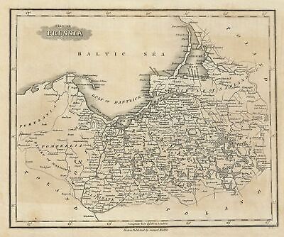
$15.00 Shipping Location: Brooklyn, United States 1828 Malte-Brun Map of Prussia or Northern Germany WE SELL ONLY ORIGINAL ANTIQUE MAPS- NOT REPRODUCTIONS Title: Part of Prussia. Description: This is ... morean attractive example of the 1828 Malte-Brun map of Prussia. The map covers part of modern day Poland and Lithuania and shows Holy Roman empire Circles. The Palatinate of Culm, Pomeralia, and Polish Prussia. Various, important rivers, islands, cities and other topographical details are noted. This map was published by Samuel Walker in 1828 as part of the American edition of Conrad Malte-Brun's System of Geography, Vol. I. Size: Printed area measures 8 inches high by 10 inches wide. Condition: Very good. Blank on verso. Original platemark visible. Overall toning. Shipping: Due to recent increases in United States Postal Service rates we have been forced to increase our shipping rates. Shipping rates are not negotiable. Items are shipped within three business days of receiving payment. We are happy to consolidate shipping where possible. The following shipping options are available: 1. USPS Domestic Express Mail(35 USD) USA Only. 2. FedEx Ground or Home Delivery(15 USD) USA Only. 1- 10 days. If your address is a P.O.Box and cannot ship FedEx we will ship USPS Priority and. While we ship promptly, recent postal personnel cutbacks mean that delivery may take up to 1 month. 3. DHL International EXPRESS(40- 50 USD) 4. We can use your Federal Express Account. Insurance: All shipments are insured privately against loss and damage. All of our shipments require a signature. If you have any questions please feel free to email us through eBay or contact us by telephone at 646-320-8650. Additional Services Conservation Framing Services: Geographicus recommends basic conservation framing services for any antique paper. Read about it here. We do not offer this service. Antique Map Restoration Services: Geographicus can repair and restore your antique map. Services include deacidification cleaning flattening and backing. BEWARE anyone attempting to contact you. From a di
Buy It Now
$15.00 Shipping Location: Brooklyn, United States Parts of Ha Long Bay are also illustrated. Census and Publication History We know that a very similar earlier map was compiled from Jesuit sources by ... moreJean Dominique Etienne Canu for publication in Yves Mathurin Marie Treaudet de Querboeuf'sLettres Edifiantes et Curieuses.
Buy It Now
Free Shipping Location: Sielow, Germany They each bid on 1 card (according to Image original photo of the respective offer), shipping costs are calculated exclusively from the shipping weight ... morevia a special shipper for large piece goods. put something together in peace and quiet West German publishers mostly have wooden sticks, see partial item description, damage is also mentioned where possible, if the hadü suspension/fastening is needed, please if necessary. Please ask or let me know if necessary. I reserve the right to dismantle inadequate/wobbly hooks; what is not on it cannot be broken or interfere with transport, and I may have. a hook for free use Purpose: children's room, teenager's room, traditional room, men's room, classroom, hallway, auditorium, for information, discussion with children, students, travelers, parents,.
Buy It Now
$15.00 Shipping Location: Brooklyn, United States 1828 Malte-Brun Map of Prussia or Northern Germany WE SELL ONLY ORIGINAL ANTIQUE MAPS- NOT REPRODUCTIONS Title: Part of Prussia. Description: This is ... morean attractive example of the 1828 Malte-Brun map of Prussia. The map covers part of modern day Poland and Lithuania and shows Holy Roman empire Circles. The Palatinate of Culm, Pomeralia, and Polish Prussia. Various, important rivers, islands, cities and other topographical details are noted. This map was published by Samuel Walker in 1828 as part of the American edition of Conrad Malte-Brun's System of Geography, Vol. I. Size: Printed area measures 8 inches high by 10 inches wide. Condition: Very good. Blank on verso. Original platemark visible. Overall toning. Shipping: Due to recent increases in United States Postal Service rates we have been forced to increase our shipping rates. Shipping rates are not negotiable. Items are shipped within three business days of receiving payment. We are happy to consolidate shipping where possible. The following shipping options are available: 1. USPS Domestic Express Mail(35 USD) USA Only. 2. FedEx Ground or Home Delivery(15 USD) USA Only. 1- 10 days. If your address is a P.O.Box and cannot ship FedEx we will ship USPS Priority and. While we ship promptly, recent postal personnel cutbacks mean that delivery may take up to 1 month. 3. DHL International EXPRESS(40- 50 USD) 4. We can use your Federal Express Account. Insurance: All shipments are insured privately against loss and damage. All of our shipments require a signature. If you have any questions please feel free to email us through eBay or contact us by telephone at 646-320-8650. Additional Services Conservation Framing Services: Geographicus recommends basic conservation framing services for any antique paper. Read about it here. We do not offer this service. Antique Map Restoration Services: Geographicus can repair and restore your antique map. Services include deacidification cleaning flattening and backing. BEWARE anyone attempting to contact you. From a di

Buy It Now
$15.00 Shipping Location: Brooklyn, United States 1874 Tardieu Map of France in Departments WE SELL ONLY ORIGINAL ANTIQUE MAPS- NOT REPRODUCTIONS Title: France Par Departments. Description: This is a ... morefine 1874 map of France divided into its constituent departments by Ambroise Tardieu. It covers from the Nord in the north to eastern Pyrenees in the south and from Finistere in the west to Upper and Lower Rhein in the east. An inset map near the lower right corner details Corsica. The French Department system was established on March 4th. 1790 by the National Constituent Assembly to replace the provinces with what the Assembly deemed a more rational structure. They were designed to deliberately break up France's historical regions in an attempt to erase cultural differences and build a more homogeneous nation. Initially there were 83 departments but by 1800 that number increased to roughly 130. Many of the departments that were created in 1790 remain the administrative districts to this day. Nonetheless, the province system was so engrained that most cartographers felt obliged to include two maps of France in their atlases, one showing the current department system, and another defining the defunct provinces. This map was prepared by Ambroise Tardieu and issued as plate 12 in his 1874 edition of Atlas Universel de Geographie Ancienne et Moderne. Size: Printed area measures 15 inches high by 17.5 inches wide. Condition: Very good. Minor wear along original centerfold. Original platemark visible. Minor spotting and some manuscript marking over the northeast borders of France. Shipping: Shipping rates are not negotiable. Items are shipped within three business days of receiving payment. We are happy to consolidate shipping where possible. The following shipping options are available: 1. USPS Domestic Express Mail(35 USD) USA Only. 2. FedEx Ground or Home Delivery(15 USD) USA Only. 1- 10 days. If your address is a P.O.Box and cannot ship FedEx we will ship USPS Priority and. While we ship promptly, recent postal personnel cutbacks mean that delivery may take up
Buy It Now
Free Shipping Location: Sielow, Germany They each bid on 1 card (according to Image original photo of the respective offer), shipping costs are calculated exclusively from the shipping weight ... morevia a special shipper for large piece goods. put something together in peace and quiet West German publishers mostly have wooden sticks, see partial item description, damage is also mentioned where possible, if the hadü suspension/fastening is needed, please if necessary. Please ask or let me know if necessary. I reserve the right to dismantle inadequate/wobbly hooks; what is not on it cannot be broken or interfere with transport, and I may have. a hook for free use Purpose: children's room, teenager's room, traditional room, men's room, classroom, hallway, auditorium, for information, discussion with children, students, travelers, parents,.
Buy It Now
$15.00 Shipping Location: Brooklyn, United States Dezhnyov's actual reports were rediscovered by Gerhardt Friedrich Muller who published them in 1758 and incorporated them into his own influential map ... moreof the Siberian Arctic. Beyond the discovery of Mount Saint Elias, much of the Pacific Northwest is notably blank.

Buy It Now
$15.00 Shipping Location: Brooklyn, United States 1874 Tardieu Map of France in Provinces WE SELL ONLY ORIGINAL ANTIQUE MAPS- NOT REPRODUCTIONS Title: France Par Provinces. Description: This is a lovely ... moreexample of the 1874 map of France by Ambroise Tardieu. The map covers the Kingdom of France showing its various divisions according to province. It covers from the Flanders in the north to Roussillon in the south and from Brittany in the west to Alsace in the east. An inset map on the lower right corner details Corsica. Throughout. The map identifies various cities, towns, rivers, lakes, roadways, railways and an assortment of additional topographical details. France was organized into provinces until March 4, 1790, when the National Constituent Assembly reorganized the Provinces into Departments. The change was an attempt to eradicate local loyalties based on feudal ownership of land and focus all loyalty on the central government in Paris. There were roughly 40 provinces in France before they were abolished. Nonetheless, the province system was so engrained that most cartographers felt obliged to include two maps of France in their atlases, one showing the current department system, and another defining the defunct provinces. This map was prepared by Ambroise Tardieu and issued as plate 11 in his 1874 edition of Atlas Universel de Geographie Ancienne et Moderne. Size: Printed area measures 15 inches high by 17.5 inches wide. Condition: Very good. Minor wear along original centerfold. Original platemark visible. Minor spotting. Shipping: Shipping rates are not negotiable. Items are shipped within three business days of receiving payment. We are happy to consolidate shipping where possible. The following shipping options are available: 1. USPS Domestic Express Mail(35 USD) USA Only. 2. FedEx Ground or Home Delivery(15 USD) USA Only. 1- 10 days. If your address is a P.O.Box and cannot ship FedEx we will ship USPS Priority and. While we ship promptly, recent postal personnel cutbacks mean that delivery may take up to 1 month. 3. DHL International EXPRESS(4
Buy It Now
Free Shipping Location: Sielow, Germany here comes if necessary. the list of my cards as well, for your information, probably not for sale or irresistible offers, most flashcards (not maps) ... morecan be safely purchased all search terms for the Excel list: IGN Perthes Haack Darmstadt Flemming Klasing Gaebler Gotha Westermann etc. and the following titles Development of the brain Grass snake Domestic pigeon Europe at the time of migration and state formation (375-580) Europe at the time of HohenstaufenFriedrich 2. (1212-50) Europe Economy Economic map Europe from 1815-1871 Europe after World War II World War 1945-1970 Europe in the XXth century 4xpol Europe in the 18th century Century Europe in the 16th century Century 1580 Europe Mining and industry Europe 1919-1945 Europe 1919-1937 Europe 1918-1937 3NK Europe 1871-1914 Europe 1848-18.
Buy It Now
$15.00 Shipping Location: Brooklyn, United States Covers both the Malabar and Coromandel coasts as well as the Maldives, Ceylon (Sri Lanka), the Andaman Islands, and parts of Sumatra and Southeast Asia. ... moreRhumb lines throughout. Arrows in the Indian Ocean show the direction of prevailing winds during the dry season and the monsoon season.
Buy It Now
$15.00 Shipping Location: Brooklyn, United States It covers the Iberian Peninsula including the islands of Majorca, Minorca and Ibiza and depicts the provinces as they appeared when the map was drawn. ... moreDominated by his wife's lover, Manuel de Godoy, Charles IV embarked on policies that regressed Spain to its pre-Charles III state.
Buy It Now
Free Shipping Location: Sielow, Germany here comes if necessary. the list of my cards as well, for your information, probably not for sale or irresistible offers, most flashcards (not maps) ... morecan be safely purchased all search terms for the Excel list: IGN Perthes Haack Darmstadt Flemming Klasing Gaebler Gotha Westermann etc. and the following titles Development of the brain Grass snake Domestic pigeon Europe at the time of migration and state formation (375-580) Europe at the time of HohenstaufenFriedrich 2. (1212-50) Europe Economy Economic map Europe from 1815-1871 Europe after World War II World War 1945-1970 Europe in the XXth century 4xpol Europe in the 18th century Century Europe in the 16th century Century 1580 Europe Mining and industry Europe 1919-1945 Europe 1919-1937 Europe 1918-1937 3NK Europe 1871-1914 Europe 1848-18.
Buy It Now
Free Shipping Location: Sielow, Germany They each bid on 1 card (according to Image original photo of the respective offer), shipping costs are calculated exclusively from the shipping weight ... morevia a special shipper for large piece goods. put something together in peace and quiet West German publishers mostly have wooden sticks, see partial item description, damage is also mentioned where possible, if the hadü suspension/fastening is needed, please if necessary. Please ask or let me know if necessary. I reserve the right to dismantle inadequate/wobbly hooks; what is not on it cannot be broken or interfere with transport, and I may have. a hook for free use Purpose: children's room, teenager's room, traditional room, men's room, classroom, hallway, auditorium, for information, discussion with children, students, travelers, parents,.
Buy It Now
Free Shipping Location: Sielow, Germany here comes if necessary. the list of my cards as well, for your information, probably not for sale or irresistible offers, most flashcards (not maps) ... morecan be safely purchased all search terms for the Excel list: IGN Perthes Haack Darmstadt Flemming Klasing Gaebler Gotha Westermann etc. and the following titles Development of the brain Grass snake Domestic pigeon Europe at the time of migration and state formation (375-580) Europe at the time of HohenstaufenFriedrich 2. (1212-50) Europe Economy Economic map Europe from 1815-1871 Europe after World War II World War 1945-1970 Europe in the XXth century 4xpol Europe in the 18th century Century Europe in the 16th century Century 1580 Europe Mining and industry Europe 1919-1945 Europe 1919-1937 Europe 1918-1937 3NK Europe 1871-1914 Europe 1848-18.
Buy It Now
Free Shipping Location: Sielow, Germany They each bid on 1 card (according to Image original photo of the respective offer), shipping costs are calculated exclusively from the shipping weight ... morevia a special shipper for large piece goods. put something together in peace and quiet West German publishers mostly have wooden sticks, see partial item description, damage is also mentioned where possible, if the hadü suspension/fastening is needed, please if necessary. Please ask or let me know if necessary. I reserve the right to dismantle inadequate/wobbly hooks; what is not on it cannot be broken or interfere with transport, and I may have. a hook for free use Purpose: children's room, teenager's room, traditional room, men's room, classroom, hallway, auditorium, for information, discussion with children, students, travelers, parents,.
Buy It Now
Free Shipping Location: Sielow, Germany here comes if necessary. the list of my cards as well, for your information, probably not for sale or irresistible offers, most flashcards (not maps) ... morecan be safely purchased all search terms for the Excel list: IGN Perthes Haack Darmstadt Flemming Klasing Gaebler Gotha Westermann etc. and the following titles Development of the brain Grass snake Domestic pigeon Europe at the time of migration and state formation (375-580) Europe at the time of HohenstaufenFriedrich 2. (1212-50) Europe Economy Economic map Europe from 1815-1871 Europe after World War II World War 1945-1970 Europe in the XXth century 4xpol Europe in the 18th century Century Europe in the 16th century Century 1580 Europe Mining and industry Europe 1919-1945 Europe 1919-1937 Europe 1918-1937 3NK Europe 1871-1914 Europe 1848-18.
Buy It Now
$155.14 Shipping Location: Sielow, Germany
Buy It Now
Free Shipping Location: Sielow, Germany here comes if necessary. the list of my cards as well, for your information, probably not for sale or irresistible offers, most flashcards (not maps) ... morecan be safely purchased all search terms for the Excel list: IGN Perthes Haack Darmstadt Flemming Klasing Gaebler Gotha Westermann etc. and the following titles Development of the brain Grass snake Domestic pigeon Europe at the time of migration and state formation (375-580) Europe at the time of HohenstaufenFriedrich 2. (1212-50) Europe Economy Economic map Europe from 1815-1871 Europe after World War II World War 1945-1970 Europe in the XXth century 4xpol Europe in the 18th century Century Europe in the 16th century Century 1580 Europe Mining and industry Europe 1919-1945 Europe 1919-1937 Europe 1918-1937 3NK Europe 1871-1914 Europe 1848-18.
Buy It Now
Free Shipping Location: Sielow, Germany here comes if necessary. the list of my cards as well, for your information, probably not for sale or irresistible offers, most flashcards (not maps) ... morecan be safely purchased all search terms for the Excel list: IGN Perthes Haack Darmstadt Flemming Klasing Gaebler Gotha Westermann etc. and the following titles Development of the brain Grass snake Domestic pigeon Europe at the time of migration and state formation (375-580) Europe at the time of HohenstaufenFriedrich 2. (1212-50) Europe Economy Economic map Europe from 1815-1871 Europe after World War II World War 1945-1970 Europe in the XXth century 4xpol Europe in the 18th century Century Europe in the 16th century Century 1580 Europe Mining and industry Europe 1919-1945 Europe 1919-1937 Europe 1918-1937 3NK Europe 1871-1914 Europe 1848-18.
|
|
|
In
|
US PULL DOWN SCHOOL MAP - United States "Modern Educational Systems Inc."
1995 US Pull Down Map. 61" wide X 48" tall. No rips or tears. Very good overall condition. HOW MANY PEOPLE DO YOU KNOW THAT USE ELECTRICITY/ NATURAL GAS? HOW WOULD YOU LIKE TO MAKE MONEY EVERY MONTH WHEN THOSE PEOPLE PAY THEIR BILL? Check out th e link below and see for yourself if this is a good fit for you& your family like it was ours. R ead my Feedback's& bid with confidence* If you have any questions or need additional photos ~ please feel free to e-mail us! EMAIL FOR ALTERNATIVE PAYMENT METHOD* As Usual. Thanks For Looking& Good Luck Bidding! After you receive your package& you are happy. Please complete the 5-STAR rating when leaving feedback* Thank you.
|
|
|
MODERN EDUCATIONAL SYSTEMS Pull Down Map of POLITICAL WORLD Model 30-25 school
MODERN EDUCATIONAL SYSTEMS POLITICAL WORLD MAP FREE SHIPPING IN THE USA EXPEDITED& WORLDWIDE SHIPPING AVAILABLE Email with any questions THIS IS A GENTLY USED MAP MAP is APPROX. 61 inches wide X 45 inches high Unit still works from the spring action release overall length of mounting bracket is approx. 64 inches Powered by
|
|
|
MODERN EDUCATIONAL SYSTEMS PullDown Roll up Map of the World Model 81-05 school
MODERN EDUCATIONAL SYSTEMS WORLD MAP FREE SHIPPING IN THE USA EXPEDITED& WORLDWIDE SHIPPING AVAILABLE Email with any questions THIS IS A GENTLY USED MAP MAP is APPROX. 61 inches wide X 42 inches high Unit still works from the spring action release overall length of mounting bracket is approx. 64 inches Powered by
|
|
|
Vtg Modern Educational Systems Dry Erase Transparency Classroom Map USA
Welcome to our company. The Bomb Shelter" which sells everything cool from the 1800's to the present. If you're local or passing through, please visit us at 923 Bank St. Akron, Ohio 44305(Telephone: 330-258-0088 Please call for hours! We have over 10,000 sq. feet of items displayed for viewing or purchase. Also, you can save shipping and pick up your purchase at our store! Here we have(12)1980 Vintage Porsche Christophorus"Perspektiven" Perspective) Calendar Art Prints. We pr ovide detailed photos which are consi dered to be part of the desc ription. Please see all pictures carefully before bidding or buying. ADDITIONAL CHARGES NOTICE: This item will have an additional packing charge of $0.00 added into the shipping and handling fees shown above due to the extra packing required for safe shipping to your location. Also. ... moreAn insurance/ tracking fee of $2.59 has been added to most USPS shipments for your item's safety. If both of these fees are $0.00. Then no additional costs have been added. YOUR SHIPPING CHARGES: We do not add or inflate shipping charges on your purchase. We use the eBay shipping system for calculating shipping costs. If eBay is off over 10% We will either refund or pay the additional shipping costs. Thank you for looking and Please Email with any questions! Please Note: All sales shipped or picked up in Ohio will have SALES TAX collected. All international or Canadian shipping/ delivery does not include any taxes. Import taxes, or duty fees and may have additional customs fees by the shipping carrier that may be due on delivery.
|
|
|
1996 Modern Educational Systems United States Pull Down Map ~ $99.00
Up for your consideration is a 1996 Modern Educational Systems United States Pull Down Map. This map is in overall excellent condition.the only discrepancy is just a slight surface line on the very bottom border of the map. If you have any questions. Please don't hesitate to ask. Thanks for your interest!
|
|
|
1996 Modern Educational Systems United States Pull Down Map ~ Nice!!!
Up for your consideration is a United States Modern Educational Systems Pull Down Map. This map is in excellent condition w/ no flaws. The measurements for this map is 61"W x 49"L. If you have any questions. Please don't hesitate to ask. Thanks for your interest!
|
|
|
MODERN EDUCATIONAL SYSTEMS World Political & United States Political Map & Rack
MODERN EDUCATIONAL SYSTEMS World Political& United States Political Map& Rack Comes with rack holder for the map.
|
|
|
2003 MODERN EDUCATIONAL SYSTEMS LITHO Political World Map Model 840-50
MODERN EDUCATIONAL SYSTEMS WORLD PHYSICAL POLITICAL LITHO MAP MODEL 840-50 BACK IS HAND WRITTEN DATED 2003 FREE SHIPPING IN THE USA WORLDWIDE SHIPPING AVAILABLE"THIS IS A GENTLY USED MAP IN EXCELLENT CONDITION. GREAT FOR EDUCATIONAL. CLASSROOM, OR BUSINESS APPLICATION. MAP is APPROX. 61 inches wide X 42 inches high. Unit still works GREAT with the spring action release. The overall length of mounting bracket is approx. 64 inches. See all pics for actual condition.
|
|
|
UNITED STATES Pull Down Map - Modern Educational Systems, INC., 1992
UNITED STATES Pull Down Map- Modern Educational Systems. INC. 1992 Model 810-10 This is a Modern Educational Systems. INC. Pull Down Map of the Unites States of America. Made in Goshen. Indiana, dated September 9, 1996. Great colors for vintage. Pull down map for school, home or office. Does not Includes top metal bracket. Dimensions: 61" Wide(across) x 51" Long Model# 810-10 Thank you for viewing my listing. If you have any questions please do not hesitate to ask. Please be sure to check my other listings. I pack well. Ship fast and do my best to combine shipping. PayPal is preferred. Prompt payment is expected. Good luck bidding and have a great day or night. RcmdId ViewItemDescV4,RlogId p4%60bo7%60jtb9%3Feog4d71f%2B%3F4f%3E-14b30c892d9-0x110-
|
|
|
MODERN EDUCATIONAL SYSTEMS School LAND-FORM SERIES Map UNITED STATES Model 20-01
MODERN EDUCATIONAL SYSTEMS UNITED STATES MAP FREE SHIPPING IN THE USA EXPEDITED& WORLDWIDE SHIPPING AVAILABLE Email with any questions THIS IS A GENTLY USED MAP SOME TAPE HOLDING THE WOOD BASE ON AS PICTURED MAP is APPROX. 61 inches wide X 48 inches high Unit still works from the spring action release overall length of mounting bracket is approx 65 inches
|
|
 |