-
Christian Collectibles
-
Christian Sheet Music
-
Vatican Stamps
-
Vatican Coins & Paper Money
-
Antiques
-
Antiquities
-
Architectural & Garden
-
Decorative Arts
-
Ethnographic
-
Furniture
-
Maps, Atlases & Globes
-
United States (Pre-1900)
-
United States (1900-Now)
-
AK, HI
-
AL, FL, GA, MS, NC, SC
-
AR, IA, KS, LA, MO, NE
-
AZ, CA, CO, NM, NV, UT
-
CT, MA, ME, NH, RI, VT
-
DC, DE, MD, NJ, NY, PA
-
ID, OR, WA
-
IL, IN, MI, OH, WI
-
MN, MT, ND, SD, WY
-
OK, TX
-
VA, WV, KY, TN
-
Entire US
-
United States (Date Unknown)
-
Africa
-
Asia
-
Australasia/ Oceania
-
Canada
-
Central America/ Caribbean
-
Europe
-
India
-
Ireland
-
Mexico
-
Middle East
-
North America
-
South America
-
United Kingdom
-
Maps on CD
-
World Maps
-
Globes
-
Mixed Lots
-
Reproductions
-
Price Guides & Publications
-
Other
|
In
Order by: Available to: This site contains affiliate links for which I may be compensated
|

Buy It Now
$5.95 Shipping Condition: New Location: Las Vegas, United States Title: nbsp Schönberg's map of Texas Subject: nbsp Classic Early Texas Map Year: nbsp 1866 Size: nbsp 24" x 28" As settlers spread ... morewest. Schönberg's map of Texas shows the growing state of Texas and the contemporary counties as of 1866. This map is a custom reproduction printed on 68lb Heavyweight Enhanced Matte Art Paper using Ultrachrome inks. Suitable for framing. Mounting or direct display, this print has a colorfast life of 125+ years. Example of Poster Detail       More Posters available from Artscape Galleries Online Shipping and Payment Information U.S. nbsp $4.95- USPS 1st Class   or   $6.95- Priority Mail Worldwide: nbsp Please Use the Shipping Calculator - nbsp                    (Both First Class International and Priority Mail International are available) Shipping price includes delivery confirmation. We combine shipping for multiple purchases- add $1.00 for each additional poster. All posters are professionally packaged to ensure that they arrive safely and undamaged: nbsp Your poster is first rolled and inserted into a plastic sleeve. That sleeve is then placed into a Heavy-Duty mailing tube and securely sealed. Pay me securely with any major credit card through PayPal! nbsp 30 Day Money Back Guarantee! nbsp Artscape Galleries stands behind the quality of every poster. If you are not satisfied with your purchase. Please contact us within 30 days to arrange for either an exchange or a full refund. Posters Pictures Classic Vintage Style Art Print Paintings Decorative Decorations Decor Artist Classic American Large Restored Antique Print Old Print Classic Canvas Impressionist Replica Historic Classic Travel Poster Antique Map Poster Civil War Map Military Map Republic of Texas Texas Territory Great Plains Old West_gsrx_vers_468(GS
Buy It Now
$5.95 Shipping Condition: New Location: Las Vegas, United States Year: 1630. Beautiful old map by Hendrik Hondius originally created in 1630. Each of our prints are custom reproductions printed on 68lb Heavyweight Enhanced ... moreMatte Art Paper. These Historic Art Prints are suitable for framing, mounting or direct display on any wall!
Buy It Now
$27.91 Shipping Location: HASLEMERE, United Kingdom Edward Mogg was a publisher in London in 19th century. This extraordinary second 1814 edition of Edward Mogg's folding map covers the central part of ... moreLondon from Kensington to Greenwich and the East India Docks.
Buy It Now
$1.63 Shipping Location: Nashville, United States Up for sale is an original antique 1837 MAP OF THE STATE OF ILLINOIS. In very nice Original antique condition. I think maybe I was the first to ever unfold ... morethe map. Would make a wonderful gift. Quite scarce.
Buy It Now
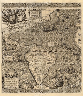
$5.95 Shipping Condition: New Location: Las Vegas, United States The New World 1562 Size: 20" x 24" 51 cm x 61 cm) x Also Available in 24" x 28" from our eBay Store This is a great Classic Map originally ... morePublished circa 1562. This Map shows the America's as it was known in the 1500's. Includes texts in cartouche. Statements of dedication, coats-of-arms, ill. of allegorical f igure"Victoria" And ill. of sailing ships at sea and imaginary marine creatures. The wording on the map reads: Americae sive qvartae orbis partis nova et exactissima descriptio/ avtore Diego Gvtiero Philippi Regis Hisp. etc. Cosmographo; Hiero. Cock excvde 1562; Hieronymus Cock excude cum gratia et priuilegio 1562" This poster. Which evokes the vivid images of a simpler time, is a custom reproduction printed on 68lb Heavyweight Enhanced Matte Art Paper. This Historic Art Print is suitable for framing. Mounting or direct display on any wall! 000 Artscape Galleries/ Posters Past More Prints and Posters Available from our eBay Store! Shipping price includes delivery confirmation. We combine shipping for multiple purchases- add $1.00 for each additional poster. All posters are professionally packaged to ensure that they arrive safely and undamaged: Your poster is first rolled and inserted into a plastic sleeve before being placed into a Heavy-Duty mailing tube for delivery. We stand behind the quality of every poster. If you are not satisfied with your purchase. Please contact us within 30 days to arrange for either an exchange or a full refund. gsrx_vers_468(GS 6.4(468)
Buy It Now
$5.95 Shipping Condition: New Location: Las Vegas, United States A beautiful map of the history of the New York City area. Commissioned in 1932 by the National City Bank of New York, this brightly colored map highlights ... morekey historical events and locations that took place in and around New York City, including Manhattan, Bronx, Queens, and Brooklyn.
Buy It Now
$5.95 Shipping Condition: New Location: Las Vegas, United States Year: 1747. This map, by Joan Vinckeboons, shows the northeast coast of the United States from New England to Virginia, including coastal features and ... moreother geographical entities. A New and Accurate Map of New Jersey, Pensilvania, New York and New England.
Buy It Now
$5.95 Shipping Condition: New Location: Las Vegas, United States This is an early (1837) map of the Republic of Texas, showing the land grants that make up the territory. Featured Land Grants and Points of Interest ... moreare Year: 1837. Map of Texas with Parts of the Adjoining States / Compiled by Stephen F. Austin.
Buy It Now
$4.15 Shipping Location: Saco, United States Up for Sale is a Beautiful Colored County Map of MINNESOTA.This Single Page Map was Harvested from an 1865 A. J. Johnson's Family Atlas. The Title Page ... moreis shown in the last photo and is not included.
Buy It Now
$6.50 Shipping Location: Dunkirk, United States Phillipines Historical Map 24x36 Rolled National Imagery & Mapping
Buy It Now
Free Shipping Location: San Antonio, United States 1856 Texas Map – High Quality Reproduction. A very colorful map of Texas in 1856. Map has age spots making it an “antique” look (Photo Art owns the original). ... moreDetailed map of Texas, colored by counties and showing the primitive county configurations in the west. Illustrates many early roads, trails, railroads, towns, forts, and other important places. States “Wild Horses and Cattle” in South Texas. Printed on high quality gloss paper. Size = 24" x 18".
Buy It Now
$5.95 Shipping Condition: New Location: Las Vegas, United States Year: 1865. This map by Egbert Viele, is a classic Topogaphical map of the city of New York and Manhattan Island. Originally prepared for the Council ... moreof Hygiene and Public Health, this map will make a conversation piece worth owning!
$6.00 Shipping Location: Corunna, United States This is an original 109 year old map, not a copy or reprint.
Buy It Now
Free Shipping Location: Buchloe, Germany After shopping, please click on the “Pay Now” button. All items we purchase are then combined into one shipment. Then select your delivery address and ... morepayment method. We ship within 24 hours after payment received. Our shipping partner is DHL. There are no shipping costs for you in Germany. For your safety, we guarantee a 30-day return policy! You can find detailed information about this in the cancellation policy and the general terms and conditions below. As always, everything was great again 👍!!! I'm looking forward to the new offers 😃 16 autographs on 10 original photos of the 2006 World Cup footballers and politicians Online dispute resolution in accordance with Art. 14 para. 1 ODR-VO: The European Commission provides a platform for online dispute resolution (OS), which you can.
Buy It Now
$40.00 Shipping Location: Trnava 1, Slovakia An original antique reprint. The reprint was made in 1924, published by Vlg. German language. Fully unfolded map (as seen on photo set in my room) : 240 ... morecm width x 140 cm height. Condition: Perfect collectible condition, very well preserved, few stains on world map and pages, but all in all - absurdly good condition.
Buy It Now
$27.59 Shipping Condition: New Location: Red Bank, United States Artist: Coulton Waugh (1896-1973) (after). Sponsored by the Hudson River Historical Museum, Crawford House, Newburgh, New York (shown below map - lower ... moreright) ©Coulton Waugh 1958. Many cities shown - Glen Falls, Hudson Falls, Saratoga, Catskill, Hudson.
$6.00 Shipping Location: Corunna, United States This is an original 109 year old map, not a copy or reprint.
Buy It Now
$5.95 Shipping Condition: New Location: Las Vegas, United States Each of our prints are custom reproductions printed on 68lb Heavyweight Enhanced Matte Art Paper. These Historic Art Prints are suitable for framing, ... moremounting or direct display on any wall! “Vibrant and bright!
Buy It Now
$5.95 Shipping Condition: New Location: United States Year: 1892. Washington DC 1892. These Historic Art Prints are suitable for framing, mounting or direct display on any wall! Washington DC. Washington ... moreDC 1852. Washington DC 1856. Washington DC 1857. Washington DC 1860.
Buy It Now
$3.75 Shipping Location: Winter Springs, United States From the very rare 1896 L.J. Richards Atlas of Worcester Massachusetts. Its not a reproduction or copy. It also shows how each house or building is made, ... morewhat it is constructed of. My scans wont show the full beauty of the map, or even all of the map.
Buy It Now
$10.75 Shipping Location: Centreville, United States This antique map from 1863 depicts the Gettysburg Campaign and is in mint condition. The map is a historical watercolor reproduction and features detailed ... moreinformation of the theater of the war. The map is perfect for collectors of antique maps and those interested in the history of the Civil War. Its format is an atlas map, and it is a valuable addition to any collection of North America maps. Don't miss out on the opportunity to own this historic piece.
Buy It Now
$5.95 Shipping Condition: New Location: Las Vegas, United States Year: 1879. Albany 1879. Brooklyn 1879. Canton 1885. These Historic Art Prints are suitable for framing, mounting or direct display on any wall! New York ... moreCity 1879. New York City 1879 (2). “Vibrant and bright!
Buy It Now
$4.40 Shipping Location: Saco, United States Up for Sale is an Antique Colored County Map of Alabama.This 2 Page Map was Harvested from an 1890 Rand McNally New Family Atlas as shown in last photo. ... moreReverse side of one page will show Northern Georgia and other Southern Mississippi.
Buy It Now
$5.95 Shipping Condition: New Location: Las Vegas, United States Charleston 1872. Year: 1872. Columbia 1872. Charleston, South Carolina. These Historic Art Prints are suitable for framing, mounting or direct display ... moreon any wall! “Vibrant and bright! Pic does not do it justice.looks amazing!”.
Buy It Now
$6.50 Shipping Location: Dunkirk, United States D-DAY Historical Map 24x36 POSTER National Imagery & Mapping
Buy It Now
Free Shipping Location: Monroeville, United States Date - 1883. Condition - Quite Nice, a very light blank border damp stain, not into map image. Size - about 14.5x20.5", double page as published.
Buy It Now
$4.15 Shipping Location: Saco, United States Actual Atlas was Surgically Dissected, it is not included. No Book Killer Here! Plenty of border for matte and framing.
Buy It Now
$5.95 Shipping Condition: New Location: United States Billings, Montana. Billings 1904. Year: 1904. These Historic Art Prints are suitable for framing, mounting or direct display on any wall! “Vibrant and ... morebright! Pic does not do it justice.looks amazing!”.
Buy It Now
$12.00 Shipping Location: Rockville, United States Up for sale is the very scarce 1822 map Geographical, Statistical and Historical Map of Arkansas Territory. Published by Carey and Lea this map shows ... morewhat was then U.S. western territory from the Great Lakes through what are now Minnesota and the Dakotas, the plain states of Nebraska, Kansas, Iowas, Oklahoma, parts of Texas etc.
Buy It Now
$8.57 Shipping Location: Celina, United States Maps are in good condition with some tears see pictures, pages and binding in good condition with some foxing, cover and back cover are either off or ... morecoming off both volumes
Buy It Now
$5.95 Shipping Condition: New Location: Las Vegas, United States A new map of the world : with all the new discoveries by Capt. Cook. Each of our prints are custom reproductions printed on 68lb Heavyweight Enhanced ... moreMatte Art Paper. These Historic Art Prints are suitable for framing, mounting or direct display on any wall!
Buy It Now
$5.95 Shipping Condition: New Location: Las Vegas, United States Year: 1705. Each of our prints are custom reproductions printed on 68lb Heavyweight Enhanced Matte Art Paper. These Historic Art Prints are suitable for ... moreframing, mounting or direct display on any wall!
Buy It Now
$4.55 Shipping Location: Oakland, United States This antique map from 1907 depicts Northwest Africa in stunning detail. Measuring 15.5x11 inches, it is an original piece from the Encyclopedic Atlas ... morecollection. The map is a must-have for collectors of antique maps and those interested in the geopolitical history of the region. The map is in its original state and has been well-preserved over the years. It is a true representation of cartography from the early 1900s, with intricate details and stunning colors. This piece is perfect for anyone looking to add a unique and historical touch to their home or office.
Buy It Now
$7.25 Shipping Location: Atlanta, United States SKU=MAP-24.
Buy It Now
$7.25 Shipping Location: Atlanta, United States SKU=MAP-16.
Buy It Now
$18.41 Shipping Location: WISBECH, United Kingdom TYPE: Antique colour (colour) atlas map. DATE PRINTED: 1903. VERSO: Blank on reverse. AUTHENTICITY: This is an authentic historic map, published at the ... moredate stated above. It is not a modern copy. IMAGE SIZE: Approx 41.0 x 29.5cm (Large).
Buy It Now
$6.00 Shipping Location: Corunna, United States This is an original 108 year old map, not a copy or reprint.
$6.00 Shipping Location: Corunna, United States This is a beautiful map with very nice detail.Map is hand colored and is dated 1865. This is a complete map with a complete small border. The large border ... moreonly extends around three sides of the map as it would have continued around the map on the opposing page.
Buy It Now
$19.95 Shipping Location: Lubbock, United States
Buy It Now
$5.95 Shipping Condition: New Location: Las Vegas, United States Year: 1718. This map, based on the 1699 voyage of Pierre Le Moyne d’Iberville. The inset in the lower right includes a plan and view of Quebec Canada. ... moreEach of our prints are custom reproductions printed on 68lb Heavyweight Enhanced Matte Art Paper.
Buy It Now
$3.49 Shipping Location: Union, United States A vintage reproduction of the 1976 Union County Historical Foundation's landmark map with over 63 individual listings between the City and County levels. ... moreDr. Allan Charles authored each landmark's descriptions in rich detail - a perfect gift for the cartographer in your life!
Buy It Now
$4.65 Shipping Location: Saco, United States Page will have normal wear, browning and slightly rough or torn edges. No Book Killer Here! Plenty of border for matte and framing. No Copies or Reprints!
$6.00 Shipping Location: Corunna, United States Map was drawn by J Drayton from Tanner's map of the US. Map was engraved by J Yaeger. This Map Is from the Encyclopedia of Geography by Hugh Murray published ... morein Philadelphia 1837. This map was attached to the book with a separate piece of paper.
Buy It Now
$5.95 Shipping Condition: New Location: Las Vegas, United States Year: 1889. Denver 1889. These Historic Art Prints are suitable for framing, mounting or direct display on any wall! Denver, Colorado. Denver 1908. “Vibrant ... moreand bright! Pic does not do it justice.looks amazing!”.
Buy It Now
$5.95 Shipping Condition: New Location: Las Vegas, United States Year: 1882. Canon City 1882. Black Hawk 1882. Buena Vista 1882. Colorado Springs 1882. Golden 1882. Greeley 1882. Gunnison 1882.
Free Shipping Location: Schertz, United States This antique map of Indiana from 1899 is a beautiful and rare find for any collector. Measuring approximately 17 inches by 29 inches, it features intricate ... moredetails of the state's geography and landmarks. The map is an original piece, adding to its historical significance. It is sure to make a great addition to any collection or a unique piece to display in your home or office. Free shipping is available within the US, and calculated shipping options are available worldwide.
Buy It Now
$7.25 Shipping Location: Atlanta, United States SKU=MAP-13.
Buy It Now
$5.95 Shipping Condition: New Location: United States Year: 1856. Washington DC 1856. These Historic Art Prints are suitable for framing, mounting or direct display on any wall! Washington DC. Washington ... moreDC 1852. Washington DC 1857. Washington DC 1860. Washington DC 1871.
Buy It Now
$4.15 Shipping Location: Saco, United States ………and a variety.
Buy It Now
$5.95 Shipping Condition: New Location: Las Vegas, United States Year: 1889. Lincoln 1889. Kearney 1889. Norfolk 1889. These Historic Art Prints are suitable for framing, mounting or direct display on any wall! Lincoln, ... moreNebraska. “Vibrant and bright! Pic does not do it justice.looks amazing!”.
Buy It Now
$6.95 Shipping Location: Dover, United States On the reverse is a nice detailed full page map of the center of Groton. Issued 1875, New York by F.W. Beers. Very detailed mid-19th century lithographed ... moremap with original hand color. Of great interest for historical genealogical purposes.
Buy It Now
$5.95 Shipping Condition: New Location: Las Vegas, United States Ticonderoga, New York. Year: 1884. Ticonderoga 1884. Ticonderoga 1891. Canton 1885. These Historic Art Prints are suitable for framing, mounting or direct ... moredisplay on any wall! New York City 1884. Sandy Hill 1884.
Buy It Now
$5.95 Shipping Condition: New Location: Las Vegas, United States Texas 1835 - Map of Land Grants. Year: 1835. This great Historic Map print shows the early state of Texas and marks the specific land grants. “Vibrant ... moreand bright! Pic does not do it justice.looks amazing!”.
Buy It Now
$6.80 Shipping Location: Easton, United States Barrow Florida Historical August 1880 ire map for city of Barrow Florida. Printed in full color using a ten color ink jet printer.
Buy It Now
$4.15 Shipping Location: Saco, United States Last Photo will show the Actual Atlas that was Surgically Dissected, it is not included. No Book Killer Here! Plenty of border for matte and framing. ... more14" x 10 1/2". Nice Map and Suitable for Framing.
Buy It Now
$7.25 Shipping Location: Atlanta, United States SKU=MAP-29.
Buy It Now
Free Shipping Location: Grapevine, United States Beautiful large color map ready for framing or gift presentation. Size: 11" x 14". We will be prompt in replying.
Buy It Now
$5.95 Shipping Location: Tampa, United States Historical Map of United States produced by the National Geographic Magazine in June 1953.Unfolded map size 41” x 26” Condition : tear on the folded side ... morewhich can be scotch taped. Otherwise very good for its age.
Buy It Now
$5.95 Shipping Condition: New Location: Las Vegas, United States New Orleans 1851. New Orleans 1851 (different). Year: 1851. New Orleans, Louisiana. New Orleans 1885. These Historic Art Prints are suitable for framing, ... moremounting or direct display on any wall! “Vibrant and bright!

Buy It Now
$8.00 Shipping Location: Rockville, United States Up for sale is a Hand-Colored. Authentic, Antique Railway Map of the State of Pennsylvania. The map measures approximately 17" x 26" Including ... morethe border area. Map is with original handcoloring and outlining and it is blank on the reverse side. It is not matted nor framed, being sold as a single sheet as show in the main picture. This map is from the New Topographical Atlas Of The State of Pennsylvania With Descriptions Historical. Scientific, and Statistical. By Professor Henry F. Walling and O.W. Gray, Civil& Top'l. Engineer. Published in 1872 by Stedman, Brown& Lyton, Philadelphia. The map has fantastic coloring to it and is a great period county map. With towns, cities, railroads, roads, etc. of the time. Excellent, detailed and interesting period map of these counties. The map is generally in Very Good condition. There is some wear and browning along the edges. There are some small tears and chips along the edges. There is a crease down the middle where it was originally bound. The bottom of the crease has a tear that extends just to the border line of the map. Other dings here and there. As well. This map is a great piece of US history! It will look very nice when framed. Please note that while I have included pictures of the front board of the Atlas and the Title Page from the Atlas this map was taken from. They are NOT included in the sale, as they are reference pieces to determine authenticity for the other maps. I would be happy to include a copy if requested. Please see my store for other great items. Inventory R-Map-26
|
|
|
In
|
Vintage 22x17 United States 1784 to 1844 Linweave Historical Map by Karl Smith
This is a Vintage 22" x 17" United States 1784 to 1844 Linweave Historical Map. At the time of the original listing. This was one of three listings for these prints, corresponding to different date ranges in US history. As found, there were three different date rates with the following quantities: 1492-1783(1) 1784-1844(4) 1845-1866(2) Due to the different quantities. We are offering each different date range in a separate listing, for purchase of a quantity of one to the number available in each group. If you purchase any combination of the original seven maps, you will pay the shipping charge for one map only. If you purchase more than one map, please make the purchases, and then wait for an invoice before paying so that I can send the correct invoice with a single shipping charge. Each map is beautifully colored with detailed ... moreillustrations via"linweave lithography" some on"70 basis" and some on"80 basis" Linweave Early American White" heavy paper stock. The copyright date on each map is 1958. Some of the features include: table of key events in US history in the legend area illustrations of events of the era on land and on sea changing topography with states in green. And territories in yellow, so that the westward expansion can be seen on subsequent maps US flags of the era at the top on the first map. The original location of Native American tribes is annotated in red along with select small illustrations. On the subsequent maps there is a table of the US Presidents of the area at the top each map has what I assume is the reproduction of the maker's signature. Karl Smith, at the lower right corner. These beautiful and educational maps are very versatile and could be used in may ways including: Framed and Matted for display in your home or in a child's bedroom or playroom dry mounted. Poster framed or conventially framed as a classroom learning aid framed and matted as decor in a restaurant or other commercial venue framed and matted for use in a museum his
|
|
|
1953 JUN National Geographic Historical Map of the United States 26 x 41" GOOD
You're bidding on an original vintage June 1953 National Geographic map of the United States. The pictures are of the actual map you will get. Map CONDITION: The map measures approx. 26 x 41"and is in very nice condition with some wrinkling. Will be shipped to USA via USPS First Class Mail with delivery confirmation. P lease check my other auctions. Perfect feedback, tenure with ebay and bid with confidence. Powered by The free listing tool. List your items fast and easy and manage your active items. RcmdId ViewItemDescV4,RlogId p4%60bo7%60jtb9%3Fv%7F.rpn30%3E-13daac774fc-0x101-
|
|
|
HISTORICAL UNITED STATES MAP 1784 to 1844 - By LINWEAVE - KARL SMITH 1958
Vintage map showing the United States from 1784 to 1844. Made by Linweave in 1958. Marked Karl Smith in lower right corner. Approximately 19.9 x 16 inches. Neat map that shows the expansion of the United States during the given period. The map was framed long ago and still has dry tape residue on the back. There are some light creases that are not visible in the photos. Minor edge wear. There are obvious areas of discoloration. Areas did not darken evenly over time where the tape was mounted on the back. This discoloration is clearly visible in the photos below. Will be shipped rolled in a Priority Mail tube. Postage: Depends on ZIP code. Will combine shipping on multiple items. If you have questions. Please send email before the final hours of the auction. An invoice will be sent within 24 hours after the auction ends.
|
|
|
1951 NATIONAL GEOGRAPHIC MAP UNITED STATES 1953 HISTORICAL MAP UNITED STATES
Two vintage maps put out by the National Geograpic Magazine. First one is a map of the United States. Dated June 1951, it measures about 34 x 25. There are a few rips& tears in the map. The second map is the Historical Map of the United States, dated June 1953, measures about the same, its in better condition than the other map& has all kinds of historical tidbits on it. Either or both would look good framed& hung on a wall. We expect payment within 3 days of the auction closing. If you can't. Please notify us of your delay& let us know when we'll expect payment. As always, you may combine items to save on postage when able. Please email me with any questions prior to bidding, but please allow us time to answer. We both work full time& we aren't always by our computer. We always answer questions as quickly ... moreas possible. Please check out our other auctions. We spend hours each week trying to find a variety of items of interest for our auctions& hope you'll be pleased. All of our items come from a smoke free but not a pet free home. Please note we get our items from a variety of places, that doesn't mean they didn't originally come from a smokers home. No personal checks accepted. God Bless The USA!
|
|
|
Scarce US Bicentennial Revolutionary War Pictorial Historical Map Psychedelic
Here is a gorgeous and scarce map from the mid-1970's that was compiled for the American Bicentennial and commemorates the American Revolution of the 1770's. and 1780's. This poster map is really a conglomeration of the Historical. Pictorial, and Commemorative genres. The objective of the map is a historical recantation of the American Revolution. 1775-1783. The map portion is simplified and yet detailed. This is a large wall map. 24 1/2" x 37 3/4" The map is really done in 2 parts: the map of the US in the center. Taking up 1/2 of the paper space. And the wide border. Taking up the other half. The map is decidedly historical. Showing all of today's Lower 48 states. The Origianl 13 Colonies/States are featured. For obvious reasons, showing place names. Troop movements, battles, and other information. The rest of ... morethe USA is a pictorial/historical account of the various territories and regions of that time. The border is the real star of the piece. It features portraits of 4 Founding Fathers. Vignettes of Revolutionary battles, historical buildings and accounts. And 5 other insert maps relative to the Revolution and evern Alaska and Hawaii, to account for all 50 states of the 1970's US and todaty. The design of the map is unique. In my opinion, because it juxtposes a very obvious Psychedelic design against the topic of the Revolutionary War- I've never seen this done before. In itself. That is strange, because being a Bicentennial map it was probably compiled about 1974-1976, when the psychedelic era was the mid- to late 1960's! This map was produced by Hammond. Inc, Maplewood, NJ for the City Savings Bank of Meriden. CT. Therefore, I believe it had limited production and distribution. It's titled. Appropriately enogh, American Revolution Bicentennial Map" The colors are deep. Bright, and almost luminous- i.e. Pychedelic. The coloration and wide unusual border really make this poster. The pape r is medium weight and the printing and coloration almost have a vinyl feel.
|
|
|
1955 Commemorative Historical Map 1845 Anniversary National City Bank Lithograph
Here is a very attractive and I believe somewhat scarce Historical Map produced and distributed by the National City Bank of Cleveland. Ohio to commemorate their 110th Anniversity in 1955. The Bank was founded in 1845. Which is the depiction of the map- it shows the US as it looked. Politically,in 1945. Perhaps the bank put this map out for its 110th Anniversary even though such a item might have been more typically produced for a 100th anniversary. But the bank was precluded from doing so due to WWII still going on for most of 1945. In fact, the map states that this is how the US looked on May 17. 1845 the day the bank was founded(see Photo 2) The National City Bank is still going strong today in NE Ohio and is one of the largest banks in the USA. Headquartered in the same building it was in 1955. This map is a lithograh made by the Jackman ... moreLithograph Co. Cleveland. The illustrator is F. Rentschler. As printed on the map(see Photo 4) The map is very colorful. It is simple in its design and does not include a lot of superfluous information not essential to its target: The States and Territories of the US in 1845. The map is designed and excecuted to make it appear older than it's age- to give it an" antique" look. This is especially so for the map's Legend which is large and nicely done(see Photo 2) This map would have had limited circulation in 1955. Probably limited to Northeast Ohio. It was probably expensive to produce, because it is of very high quality for a give-away map, and this was the 1950's, not the 1930's. The map is a large wall. Or poster, map: 32 3/4" x 22 1/2" It comes with its original mailing tube which has an old 5 cents cancelled stamp and original mailing label still on it(see Photo 10) The map is in great shape except for the extreme edges. It has been tightly rolled. As originally, and stored in the tube, protecting its beautiful colors from fading. Please see the Description Section where I go into detail as to condition. This is a very nice poster for
|
|
|
Vintage 1960 America's Literary Heritage Pictorial Historical Map Excellent
Here is a very neat smaller poster map from 1960 entitled. A Reader's Map of the Names. Works, and Locations from America's Literary Heritage. 1752-1960" This map's own heritage comes from the Pictorial Map genre that came to prominence in the 1920's and flourished in the 1930's. Then continued, lesser, up to about the time this map was printed. The map is not marked as to publisher. Designer, cartographer, or distributor. But I suspect it might have been a premium offered by Reader's Digest(if you know. Please inform me and I'll update the listing) Nonetheless, this is a nice, simplified map of the United States that displays exactly what it says in the title. Its art work does not look like that from 1960. But reminiscent of the 1950's or 1940's, at least to my eye. It is simplified in design and ... moremoderate in pictorialization, yet the map is very full of small illustrations. Place names, and descriptions. The base map shows only the 48 lower state boundaries. Mountains, and the Great Lakes. But it is fairly colorful in the oceans. The map's paper, about 30 lb weight, is a nice dark Manilla color, and the printing looks like a burnt tan and greenish blue. t has a nice North Arrow and nice Key. The map is in excellent condition- please see the Description Section where I go into detail as to condition. The map is 18" x 12" It was originally folded into 4 equal size panels. And has not been further folded. The East Coast, New England, and New York areas are particularly full of wording and short epitaphs relative to American Literature. During the pictorial map era, several map posters using the literature theme were produced, a few very choice to collectors. I think this one is somewhat obscure and"free-standing" a nice small map poster. I ship USPS. Fedex, or UPS, depending on which is the most practicable given the item being shipped. This would come USPS First Class mail. I reimburse immediately via Pay Pal for any shipping fees sent that are not
|
|
|
Hoffman & Walker's pictorial historical map of Texas
Up for auction is a historic map of Texas. Details of all the Areas of Texas. There is a small tear in the upper left area. There are some marks which i have taken pictures of. Please feel free to ask me questions. Thanks for looking and happy bidding. Posted with
|
|
|
1940 National Geographic Pictorial Historical Exploration Map Southwest USA Deco
Here is a nice early National Geographic Society full size map entitled" The Southwestern United States" During this era. And later, Nat Geo compiled many regional maps to accompany feature articles in their monthly magazines. During this era, the 1930's and 1940's, Nat Geo produced many true Pictorial Maps which also doubled or tripled as Historical and/or Thematic Maps. This map features a very distinctive and artistic border that is executed in the Art Deco style prevalent in this era. The Great Depression. Nat Geo maps are also cartographically accurate and utilitarian, complied in varying degrees of sophistication and complexity. The geographic information on this map is particularly detailed. Actually. The area covered in this map as the Southwestern USA is quite large, approximately 1/5 of the US. This map also has ... morethe theme of Exploration. There is a very attractive Key that is indexed to 24 sites on the map that commemorate historical explorations into the Southwest. The map's chief cartographer i s James M Darley. It is copyrighted 1940 and printed by A. Hoen& Company. Baltimore. The print is an original lithographic copy. The artwork associated with this map is located within its highly decorative and Art Deco design border. There are 16 round illustrations picturing famous places and structures located in the Southwest. Such as the Golden Gate Bridge and Hoover Dam, both less than 10 years old when this map was published. The map is a large wall map, 34 3/4" x 26" It was folded originally into 16 equal size panels. This map is in excellent if not near mint condition. Please see the Condition Section where I go into detail as to condition. Not the rarest of early National Geographic maps. But one of the most detailed geographically and best stylized artistically. I ship USPS. Fedex, or UPS, depending on which is the most practicable given the item being shipped. This would come USPS First Class Mail. I reimburse immediately via Pay Pal for any shipping fees sent that
|
|
|
Hoffman & Walker's pictorial historical map of Texas, Framed, Some Wear
Some age and staining. Shown best in the last photo, showing the"gulf of Mexico" Great piece, though, and the rustic frame adds to the charm. Note, the shipping is probably more than I will need, because of the packing being hard to estimate. Therefore, you may get a partial refund on shipping, if I don't need it all. Thx. Posted with
|
|
|
Vintage Industrial Framed NWDA United States Distribution Map 1950 Historical
This United States Map is titled"N.W.D.A. Distribution Map of the United States. 36 PRIMARY AREAS OF WHOLESALE INFLUENCE" and has different areas highlighted in red. The midwestern area is highlighted in blue marker with certain cities marked with blue dots. It has a list of"Cities With NWDA Wholesalers by N.W.D.A. areas" across the bottom and reads"Base Map Copyright by Hogstrom Co, Inc. in fine print under the map with"This Week Magazine 1950" in the bottom right hand corner. It's contained in a grey wooden frame and measures 22 1/2" x 26 3/4" and 1/2" thick. This is a neat piece of Americana that would add charm and vintage sophistication to any workshop, office or studio. This is a vintage item that is worn but in good condition for its age as pictured. Bulbs are not included unless ... morespecified I also have a wonderful selection of other industrial artifacts. Please feel free to browse! Please give me a call with any questions you may have 815-299-7625 Happy bidding PLEASE READ THE FOLLOWING VERY CAREFULLY There is a $10.00 handling charge on all international orders. We can accept NO RETURNS. REFUNDS, ETC. ON INTERNATIONAL ORDERS. We are in no way responsible for damages that may occur during transit. International orders should expect to have an additional 3-5 day handling time. BUYERS ARE RESPONSIBLE FOR ANY DUTIES AND TAXES THAT MAY APPLY. SHIPPING PRICES REFLECT THE FACT THAT ALL OF OUR ITEMS ARE INSURED FOR THEIR VALUE. SHIPPING COSTS ARE AN ESTIMATED REPRESENTATION; ACTUAL COSTS MAY VARY BASED ON ITEM AND DESTINATION. You are welcome to pick up your items with an appointment with no additional charges. Skidding charges will still apply. NO PAYPAL FOR WILL CALLED ITEMS INTERNATIONAL CUSTOMERS: Items shipped to some countries cannot always be insured for their full value. In these cases. We will insure them to the full extent available, but will not be responsible for additional damages above the available insured amount. International items are shipped
|
|
|
1955 Historical Commemorative Map 1845 Centenial National City Bank Cleveland
Here is a fairly scarce Historical Map Commemorating the 110th Anniversary of the Founding of the National City Bank in Cleveland. Ohio in 1955. The map shows the United States as it was in on May 17. 1845. The day the bank opened. National City is still in operation and one of the largest banks in the US today. This map has a Transportation Theme and shows canals. Railroad lines, trails, and the routes of the famous. But short lived Pony Express. Although the map features the 27 states in existence in 1845, it hints at the westward expansion of the United States. This was the height of the"Manifest Destiny" era. The map is a lithograph produced by the Jackman Lithograph Company. Cleveland. It is dated May. 1955. Apparantly. National City Bank had this map created and distributed them during their 110th Anniversary year as souvenirs, ... moreso they had a limited production and an intended limited distribution. The illustrator is F. Rentschler. I am not familiar with this illustrator. Nor have I ever seen this style of map- it is" modern" in terms of the bright. Deep colors of the states. Yet the map is purposely prepared to look" old" Rentschler does the Key as one would be seen on maps from the 19th Century and adds blothchy or spongy dabs of gray to give the map a dusty or sepia look. I think this is a unique design. Actually. The map has more of a 1960's slightly Peter Maxx style to it than something that you normally see in the 1950's. The map is printed on flat off-white. But not Manilla or ivory colored heavy stock paper. The Compass on the map is very attractive. This map is 22 1/2" x 33" All in all. A rather unique map creatively combining properties of history. Transportation thematics, advertising, pictorials, commemoration, and art. I ship USPS. Fedex, or UPS, depending on which is the most practicable given the item being shipped. This would come USPS Priority Mail. I reimburse immediately via Pay Pal for any shipping fees sent that are not needed. Pay Pal only
|
|
|
VINTAGE LARGE HISTORICAL MAP OF THE UNITED STATES National Geographic June 1953
Historical Map of the United States National Geographic June 1953 This large one-sided poster is in great condition. Some folds showing wear and need to be reinforced. It is 26" x 40" Posted with 16.RcmdId ViewItemDescV4,RlogId p4%60bo7%60jtb9%3Feog4d71f%2B%3E16%3E-148a1901675-0x111-
|
|
|
Historical Map Of United States June 53
26x41 map of UNITED STATES HISTORICAL MINOR WEAR EVERYTHING IS CLEAR Posted with
|
|
|
1953 National Geographic Historical USA Map, see scan for condition
1953 National Geographic Historical USA Map. See scan for condition Normal 0 MicrosoftInternetExplorer4 Thank you for viewing my auction. Please see the ad for shipping methods. We will not be responsible for the estimated shipping delays stated by USPS. Insurance is the responsibility of the winning bidder and highly recommended. All items shipped Priority Mail come with a small amount of insurance. Auction is for USA shipping only. All items sold outside CUSA will be shipped via Ebay’s Global Shipping Program. I cannot quote shipping costs because of Global Shipping Program is a re-shipper and I do not know their fees. If the above description of item for auction is incorrect. The photograph(s) of said item is the item that is being auctioned. PAYPAL is our only method of payment for USA. We will wait until the financial transaction is ... morecleared before shipping. We only ship to the same address as your payment billing address. The winning bidder must respond within 24hrs of the end of the auction indicating method of payment. All payments made via PAYPAL will be shipped within 24-36 hours of verification of payment receipt. All NON-PAYMENT winners will receive negative feedback. The item you are bidding on is being sold as is. Those bidders with zero feedbacks or excessive negative feedbacks please consult us before bidding. And last but not least I will try to answer all questions asked. So if you have a question that needs to be asked please do it early. I cannot guarantee to answer any question that is asked within the last 24hrs of the auction. Thanks and Happy Bidding We reserve the right to refuse any or all bids. If there is ever a problem with your purchase. Please contact us BEFORE leaving neutral/negative feedback or opening a Ebay resolution case. Please select"OTHER" as the reason to contact us. We always try 100% to work with the buyer if there is a problem. However. We can't help you if you don't at least give us a chance! Immediate payment is required for all"Buy It Now"
|
|
|
Old 1931 1932 Map of Airports USA Military Historical Aviation Airplanes Flying
Special Map No.1 1931-1932 The Command and General Staff School Fort Leavenworth. Kansas Military Airport Map of the United States 1931-32 Showing Locations Capable of Accommodating Air Corps Squadrons Size: 29" H/Tall 46 1/4" Long Border 1" Somewhat age Yellowed/Crease on R side Border Select Your Choice of Shipping at Checkout- Please contact me before you pay so I can fix your invoice(in tube it is just a smidge over 13 ounces- can't go 1st class-sent priority) OR(can be folded& sent 1st class) Thank You for Looking-see other Items for Sale-more military
|
|
|
Seat of Operations Civil War United States History Historical Map 1902 Dodd Mead
Antique historical map showing the seat of operations during the US Civil War. 1861-1865. Map is copyright 1902 by Dodd, Mead and Company. This is an original map from an early 1900's encyclopedia. Condition: Very good. Minor edge wear. Age toning typical of antique maps. Back side is blank. Approximate dimensions: Page: 9.75 x 7.25" Map: 8.25 x 5.25" Ships in a protective sleeve backed by rigid cardboard. In a weather-resistant mailer. PAPER CONDITION. Because most of the prints and advertisements were once in books or magazines. They all have at least a small bit of wear. Although there are differences in the amount of wear, items and prints are worthy of framing or another type of display. Items of interest that are in less than“good” condition are sometimes offered in small lots for scrapbookers, collage artists, etc. Paper ... moreitems may have rough edges and/or staple holes on one margin from being bound in a book or magazine. Depending on the item and the size of the margin. The holes and/or raw edge has been left as is or trimmed. Excellent: In unusually good condition. With minimal signs of handling. No tears or creases. Colors still vivid. Paper may be yellowed from age, but it is even and natural in appearance. Very Good: In above average condition. With only minor edge wear(bent corners, small creases in margin areas) Flaws are in margin areas and would be covered by a frame or mat. Any dirt is only visible upon close examination(this mostly pertains to front or back covers) Good: Flaws are more apparent than with items in Very Good condition. But item is still suitable for framing or casual display. May also have more obvious wrinkles, creases or moisture or other staining along the edges or in margin areas which would be covered by a frame. May be writing that has been erased and is only visible upon close examination. Fair: More extensive wear. Including more extensive tears, creases, wrinkles or writing. Items in fair condition are usually sold in the Paper Ephemera for Scrapbooking and
|
|
|
Decorative Educational Roll Down Educational Map 18 Maps Historical USA in one
18 Maps. 55 Inches long heavy piece. 1. Claim Of National Of North America 2. Early Grant& Original 13 Colonies 3. European claims 1754-63 4. Early Settlements 1860 5. 13 colonies 1760- 1775 American industrial political 6. Western land_claims 1787 7. USA 1790-1802 8. USA 1810 9. USA 1830 10. Train River Period 1816-1840 11. Mexican War Compromise 1850 12. Territory Expansion 1854 13. USA 1861 14. Civil War 1861-1865 15. Westward of population 1870 16. Early Railroad 1840-1880 17. four impact since civil war 1884-96 1812-20 18. Colonial possession 1914 Buyer Should pay or contact ne within 48 hours of end of auction
|
|
 |