-
Christian Collectibles
-
Christian Sheet Music
-
Vatican Stamps
-
Vatican Coins & Paper Money
-
Antiques
-
Antiquities
-
Architectural & Garden
-
Decorative Arts
-
Ethnographic
-
Furniture
-
Maps, Atlases & Globes
-
United States (Pre-1900)
-
United States (1900-Now)
-
AK, HI
-
AL, FL, GA, MS, NC, SC
-
AR, IA, KS, LA, MO, NE
-
AZ, CA, CO, NM, NV, UT
-
CT, MA, ME, NH, RI, VT
-
DC, DE, MD, NJ, NY, PA
-
ID, OR, WA
-
IL, IN, MI, OH, WI
-
MN, MT, ND, SD, WY
-
OK, TX
-
VA, WV, KY, TN
-
Entire US
-
United States (Date Unknown)
-
Africa
-
Asia
-
Australasia/ Oceania
-
Canada
-
Central America/ Caribbean
-
Europe
-
India
-
Ireland
-
Mexico
-
Middle East
-
North America
-
South America
-
United Kingdom
-
Maps on CD
-
World Maps
-
Globes
-
Mixed Lots
-
Reproductions
-
Price Guides & Publications
-
Other
|
In
Order by: Available to: This site contains affiliate links for which I may be compensated
|
Buy It Now
$14.99 Shipping Location: Ivanhoe, Australia Paris in 1817 - dated. Date: - 1817. This atlas contains 22 (of 27) copper-plate engraved prints & map, listed below, sold as a collection of prints. ... moreThe object of Captain Cook's second Pacific Ocean voyage was to confirm the existence of a theorized Great Southern Continent.
Buy It Now
$14.99 Shipping Location: Ivanhoe, Australia Apia village still exists within the larger modern capital of Apia which has grown into a sprawling urban area with many villages. Ernest Goupil was a ... moreFrench painter, draftsman and watercolourist He is known for the illustrations made as official painter for Dumont D Urvilles 2nd Voyage to the South Seas.
Buy It Now
$14.99 Shipping Location: Ivanhoe, Australia Dumont was now 35 and in poor health. This greatly disturbed Dumont in subsequent years. Dumont d Urville was a French explorer, naval officer and rear ... moreadmiral, who explored the south and western Pacific, Australia, New Zealand and Antarctica.
Buy It Now
$14.99 Shipping Location: Ivanhoe, Australia Sainson was a French draftsman & artist who specialized in natural history and geography. It is part of the Temotu Province of the Solomon Islands. Tikopia ... moreis a small high island in the southwestern Pacific Ocean.
Buy It Now
$4.99 Shipping Location: Fairview, United States Atlas de toutes les parties connues du globe terrestre, published around 1780, afacsimile copy of the title page is included, which is undated. Bonne ... moreworked under Jacques Nicolas Bellin and succeeded him as the Royal Hydrographer of the King of France in 1773.
Buy It Now
$4.99 Shipping Location: Fairview, United States An Authentic Antique Map: Not a Modern Reproduction! There is a crease on the upper right corner in the margin, a couple of very minor smudges in the ... moremargin, otherwise it is very clean, see the pics for more on condition.
Buy It Now
$4.99 Shipping Location: Fairview, United States Atlas de toutes les parties connues du globe terrestre, published around 1780, afacsimile copy of the title page is included, which is undated. Bonne ... moreworked under Jacques Nicolas Bellin and succeeded him as the Royal Hydrographer of the King of France in 1773.
Buy It Now
$4.99 Shipping Location: Fairview, United States Orbis Antiqui Descriptio Atlas, (Gotha: Justus Perthes, 1866). It is designed by Friedrich von Stulpnagel as stated in the bottom left margin and the ... morepublisher Justius Pethes is stated in bottom center margin.
Buy It Now
$14.99 Shipping Location: Ivanhoe, Australia Dumont was now 35 and in poor health. This greatly disturbed Dumont in subsequent years. Dumont d Urville was a French explorer, naval officer and rear ... moreadmiral, who explored the south and western Pacific, Australia, New Zealand and Antarctica.
Buy It Now
$9.99 Shipping Location: Ivanhoe, Australia . published by Alexander Hogg, London 1784. On his last voyage, Cook again commanded HMS Resolution, while Captain Charles Clerke commanded HMS Discovery. ... moreHe arrived in Tahitis Matavai Bay, commanding the HMS Endeavour on 12 April 1769.
Buy It Now
$44.99 Shipping Location: Ivanhoe, Australia The map was engraved by Jodocus Hondius the younger and published by Willem Blaeu in the 1643 French edition ofAtlas Novus. In 1672 a disastrous fire ... moredestroyed Blaeu\\\'s printing house in the Gravenstraat and a year afterwards Joan Blaeu died.
Buy It Now
$4.99 Shipping Location: Fairview, United States Atlas de toutes les parties connues du globe terrestre, published around 1780, afacsimile copy of the title page is included, which is undated. Bonne ... moreworked under Jacques Nicolas Bellin and succeeded him as the Royal Hydrographer of the King of France in 1773.
Buy It Now
$4.99 Shipping Location: Fairview, United States Condition: The map is in Very Good to Excellent condition printed on a buffed colored page. The pics are of the actual map, although the actual map generally ... morelooks much better. An Authentic Antique Map: Not a Modern Reproduction!
Buy It Now
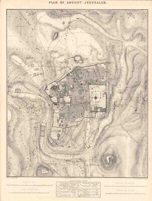
$25.00 Shipping Location: Belvedere Tiburon, United States Click Here. Double your traffic. Get Vendio Gallery- Now FREE! Plan Diagram Solomons Herods Temple Ancient Jerusalem 1853 Hand Colored Engrav SOLOMONS ... moreTEMPLE Original 1853 engraving" Plan or Solomons Temple. hand colored. This 158 year old engraving features Solomons Temple showing court of the Woman, Court of the People, and Court of the Priests. Also shown is the plan of Herods Temple. Minor foxing otherwise very good condition, overall size 10" x 6" Purchase with confidence. We have been in the antique print, map, and document business since 1976 and guarantee our items as advertised. See additional photos below! To See More Photos/Scenes Pay via PayPal. US Funds only. We ship 7 business days(excludes Saturday and Sunday) from receipt of payment. Shipping if buying multiple items within 7 day period. We will ship in one package for one item's shipping fee( as long as size permits) International shipping please contact us for a quote prior to bidding. Thank you for your business. Powered by We ship in 5 business days form receipt of payment. If you need it faster please advise. We can usually meet most dead lines.
Buy It Now
$4.99 Shipping Location: Fairview, United States Atlas de toutes les parties connues du globe terrestre, published around 1780, afacsimile copy of the title page is included, which is undated. Bonne ... moreworked under Jacques Nicolas Bellin and succeeded him as the Royal Hydrographer of the King of France in 1773.
Buy It Now
$4.99 Shipping Location: Fairview, United States It is from the Ninth Edition ofThe Encyclopedia Britannica, as stated in the bottom margin. It has brilliant color printed on nice paper that is still ... morevery bright. Condition: The map is in Good condition with a centerfold as issued, blank on reverse.
Buy It Now
$4.99 Shipping Location: Fairview, United States Orbis Antiqui Descriptio Atlas, (Gotha: Justus Perthes, 1866). It is designed by Friedrich von Stulpnagel as stated in the bottom left margin and the ... morepublisher Justius Pethes is stated in bottom center margin.

Buy It Now
$4.99 Shipping Location: Fairview, United States Click Here. Double your traffic. Get Vendio Gallery- Now FREE! Lake Erie Maps& Prints An Authentic 1860 Antique Map: Not a Modern Reproduction! Click ... moreHere for more Antique Maps and Prints No Additional Shipping Fees on Multiple Maps Shipped with the Largest Free Shipping on 5 or More Maps and Prints Description: It is an authentic antique copper engraved map over 175 years old with original hand coloring as issued. It is from Smith's Atlas for Schools. Academies and Families by Roswell Smith(Hartford: Daniel Burgess& Co. 1835) a copy of the atlas title page is included for authenticity. The map is not mounted, matted nor framed being sold as seen in the main pic, photographed against a dark background. Overall, a very nice rare early map showing a much different configuration of borders than today. Size: The image area measures 8 1/2 by 10 3/4 inches(22x27cm) within the neat lines and the entire page measures 9 3/4 by 12(25x30cm) as seen in the pic. Condition: It is in Good condition for its ages. Printed on a light buff page, blank on the reverse with original handcoloring. It is basically as seen in the pics. There is a light damp stain in the bottom center, a bumped corner, otherwise the map area is very clean and would frame up well, see the pics for more on condition. Pics are of the actual map. The details pics are more accurate in color. Payment Details: We accept most major credit cards through Paypal and Ebay. Please ask if you have any questions about payment. International and New Bidders are welcomed and encouraged. Payment is expected within 7 days. After which Nonpaying Bidders will be reported to Ebay to recoup our listing fees. Shipping: $3.50 for First Class or $4.95 for Priority Mail with Delivery Confirmation in the USA; $4.95 for First Class International to Canada; $8 for International Airmail elsewhere in the World or $20 for Registered International mail. We ship daily. So if still bidding send us a quick email to hold or better just pay all at once at the end. Save on Shipping:
Buy It Now
$44.99 Shipping Location: Ivanhoe, Australia Dedicated to Philip III of Spain it is a history of the New World to date, recording its discovery, natural history etc. Cornelius was the son of Catherine ... moreHuybrechts and her husband, Gregorius Wytfliet, who was advocate fiscal of Leuven University from 1557 to 1594.
$44.99 Shipping Location: Ivanhoe, Australia In 1672 a disastrous fire destroyed Blaeu's printing house in the Gravenstraat and a year afterwards Joan Blaeu died. Joan Blaeu 1596-1673. Date: - 1655. ... more(Ref: Koeman; M&B). Martinis map was to provide the most accurate depiction of the general outlines of the principle islands of Japan - Honshu, Kyushu and Shikoku - for more than a century.
Buy It Now
$5.95 Shipping Condition: New Location: United States Andreas Cellarius was born in 1596 in Neuhausen, Germany, but was educated in Heidelberg. From 1625 to 1637, he worked as a schoolmaster in Amsterdam ... moreand The Hague. In 1637 he was appointed rector of the Latin School in Hoorn which is where he wrote the Harmonia Macrocosmica, along with other scholarly works.
Buy It Now
$4.99 Shipping Location: Fairview, United States Atlas de toutes les parties connues du globe terrestre, published around 1780, afacsimile copy of the title page is included, which is undated. Bonne ... moreworked under Jacques Nicolas Bellin and succeeded him as the Royal Hydrographer of the King of France in 1773.
Buy It Now
$4.99 Shipping Location: Fairview, United States Geographie Moderne,published in Paris, Ano XII (1804). Both the Napoleon Era date of Ano XII and 1804 are on the title page. It is from a French edition ... moreof the Atlas during the Napoleonic era. A copy of the title page is included for authenticity.
Buy It Now
$14.99 Shipping Location: Ivanhoe, Australia He was responsible for a number of exquisite drawings of peoples and views during the voyage that were later used for lithograph prints for publication. ... moreMangareva is the central and largest island of the Gambier Islands in French Polynesia.
Buy It Now
$14.99 Shipping Location: Ivanhoe, Australia Dumont was now 35 and in poor health. This greatly disturbed Dumont in subsequent years. Dumont d Urville was a French explorer, naval officer and rear ... moreadmiral, who explored the south and western Pacific, Australia, New Zealand and Antarctica.
Buy It Now
$3.95 Shipping Location: Clarkston, United States Geological Investigation of the Alluvial Valley of the Lower Mississippi River. The Alluvial Valley of the Lower Mississippi River. Harold Fisk, 1944. ... moreAnd the 1944 report by Fisk. At top, the confluence of the Mississippi and Ohio Rivers as seen by Google Earth.

Buy It Now
$3.95 Shipping Location: Clarkston, United States Rare Map Collection This DVD is part of our Historic Map and Atlas Collection. We have dozens of Atlas maps on DVD and CD ranging from the 1500s to the ... more1900s covering many areas and topics. Please Check our Ebay Store for what's available. FOR MANY MORE EDUCATIONAL CD TITLES ON THIS AND MANY OTHER SUBJECTS PLEASE VISIT OUR EBAY STORE VERY LARGE HIGH RESOLUTION MAP COLLECTION ON DVD! please see full table of contents and sample illustrations below) This DVD Contains 201 Maps of Tennessee Including 12 PANORAMIC MAPS of various Tennessee Cities These are scans of the ORIGINAL maps by various Cartographers. on DVD System requirements PC or Mac compatible. Files are simple PDF files with a basic HTML interface(just like viewing a webpage) Works with ALL versions of Windows. Maps of Tennessee' A preliminary agricultural map of Tennessee based on the distribution of geological formations. 1896 Tennessee Centennial Exposition. Nashville, Tennessee, 1897. Sketch of the environs of Shelbyville. Wartrace& Normandy, Tennessee Compiled from the best information under the direction of Capt. N. Michler, Corps of Topographical Engrs. U.S.A. by John E. Weyss, Maj. Ky. Vols. Chief Asst. Drawn by C. S. Mergell. Photographed by M. Carpenter. 1863 Tennessee-North Carolina. A map of the Tennessee government. Formerly part of North Carolina. 1795 Reconnaissance erosion survey of the State of Tennessee. 1934 Middle Tennessee/ G.H. Blakeslee-1863. Alternate title at bottom: Fourteen trips across Tennessee 1862-1864 Tennessee. 1826 National Park Service recreational map of Tennessee.195? State of Tennessee. Roadless and undeveloped area evaluation II, RARE II final environmental statement: January 1979/ U.S. Department of Agriculture, Forest Service, Southern Region. A new map of Tennessee. 1850 Mountain region of North Carolina and Tennessee. 1864 The state of Tennessee. 181? The Virginia. Tennessee, and Georgia Air Line; the Shenandoah Valley R.R. Norfolk& Western R.R. East Tennessee, Virginia, Georgia R.R. its lease
Buy It Now
$4.99 Shipping Location: Fairview, United States Atlas de toutes les parties connues du globe terrestre, published around 1780, afacsimile copy of the title page is included, which is undated. Bonne ... moreworked under Jacques Nicolas Bellin and succeeded him as the Royal Hydrographer of the King of France in 1773.
Buy It Now
$14.00 Shipping Location: Cleveland, United States Date of Publication Dated on title page 1825. (mislabled as No. [Caption title:] Pantographie de l'Histoire d'Amérique. Condition In overall very good ... moreto condition. Contemporary half calf over pastepaper boards, expertly rebacked with original spine backstrip laid down over new spine. ).
Buy It Now
$4.99 Shipping Location: Fairview, United States Atlas de toutes les parties connues du globe terrestre, published around 1780, afacsimile copy of the title page is included, which is undated. Bonne ... moreworked under Jacques Nicolas Bellin and succeeded him as the Royal Hydrographer of the King of France in 1773.
Buy It Now
$4.99 Shipping Location: Fairview, United States It is fromWarren's Common- School Geography, published in Philadelphia by Cowperthwait & Co., 1882, a copy of the title page is included. An Authentic ... moreAntique Map: Not a Modern Reproduction! Condition: It is in Good condition for its age with overall light tonal ageing.
Buy It Now
$4.99 Shipping Location: Fairview, United States It is from the Ninth Edition ofThe Encyclopedia Britannica, as stated in the bottom margin. It is by W. & A.K. Johnston, stated in the bottom right margin. ... moreIt has brilliant color printed on nice paper that is still very bright.

Buy It Now
$3.99 Shipping Location: West Richland, United States ULTIMATE PANORAMIC MAPS COLLECTION THE ULTIMATE VINTAGE PANORAMIC MAPS COLLECTION DEAL! OVER 1.400+ VINTAGE PANORAMIC MAPS ON 3 DVD-ROM DISKS! PLUS AS ... moreA SPECIAL BONUS ALSO INCLUDED IS THE RARE 1570"THEATRUM ORBIS TERRARUM" WORLD MAP COLLECTION BY ABRAHAM ORTELIUS! A $9.99 VALUE! INCLUDED HERE ABSOLUTELY FREE! THIS IS ABSOLUTELY THE LOWEST COST FOR THIS COLLECTION YOU WILL FIND. OTHERS ARE SELLING INDIVIDUAL DISKS FOR $9.99 AND THE FULL MAP COLLECTION(THEIRS ARE ONLY 1.300 MAPS AND 30+ CD DISKS) FOR $149.00! DO YOU REALLY NEED 30+ DISKS! PLUS WITH THEIRS YOU HAVE TO INSTALL SPECIAL SOFTWARE JUST TO VIEW THESE MAPS! WE SAY NO WAY TO THE HIGH PRICES AND SOFTWARE! WE ACQUIRED THE LATEST MAPS FROM THE U.S. GOVERNMENT AND PAINSTAKINGLY RE-DIGITIZED THEM MAKING SURE THAT THESE MAPS WOULD HAVE A COMPARABLE QUALITY TO THE ORIGINALS AND WE DID IT! NOW YOU CAN VIEW. EDIT OR PRINT FROM YOUR FAVORITE PICTURE VIEWING SOFTWARE ALREADY INSTALLED ON YOUR COMPUTER! THESE ARE ALL IN HIGH QUALITY JPEG FORMAT AND ALL FILES HAVE DESCRIPTIVE NAMES WITH STATE AND CITY NAME TO EASILY FIND WHAT YOU ARE LOOKING FOR. The panoramic map was a popular cartographic form used to depict U.S. and Canadian cities and towns during the late nineteenth and early twentieth centuries. Known also as bird's-eye views. Perspective maps, and aero views, panoramic maps are nonphotographic representations of cities portrayed as if viewed from above at an oblique angle. Although not generally drawn to scale, they show street patterns, individual buildings, and major landscape features in perspective. This collection has over 1,400 panoramic maps, the bulk of which were done by Albert Ruger, Thaddeus Mortimer Fowler, Lucien R. Burleigh, Henry Wellge, and Oakley H. Bailey. These five artists prepared more than 55 percent of the panoramic maps. The tradition of perspective mapping flowered in Europe in the late sixteenth and early seventeenth centuries. Mathias Merian. George Braun, Franz Hogenberg, and others produced perspective maps of European c
Buy It Now
$14.99 Shipping Location: Ivanhoe, Australia Ernest Goupil was a French painter, draftsman and watercolourist He is known for the illustrations made as official painter for Dumont D Urvilles 2nd ... moreVoyage to the South Seas. InVoyage to the South Pole and in Oceania on corvettes l\'Astrobale and Zélée, executed by order of the king during the years 1837-1838-1839-1840, his drawings are transposed on stone, most notably by Emile Lassalle, Pharamond Blanchard and Adolphe Jean-Baptiste Bayot.
Buy It Now
$9.99 Shipping Location: Ivanhoe, Australia (Ref: Tooley; M&B). The whole illustrated with a variety of fine cuts, London, 1739 (another edition, brought down to 1756, 2 vols. 1756, 3rd edition ... more1700, 4th edition 1769). An edition enlarged and continued to 1772, by John Entick, appeared in 1775.
Buy It Now
$5.95 Shipping Condition: New Location: United States Andreas Cellarius was born in 1596 in Neuhausen, Germany, but was educated in Heidelberg. From 1625 to 1637, he worked as a schoolmaster in Amsterdam ... moreand The Hague. In 1637 he was appointed rector of the Latin School in Hoorn which is where he wrote the Harmonia Macrocosmica, along with other scholarly works.
Buy It Now
$4.99 Shipping Location: Fairview, United States It is fromWarren's Common- School Geography, published in Philadelphia by Cowperthwait & Co., 1882, a copy of the title page is included. An Authentic ... moreAntique Map: Not a Modern Reproduction! Condition: It is in Good to Very Good condition for its age with overall light tonal ageing.
Buy It Now
$4.99 Shipping Location: Fairview, United States
Buy It Now
$5.95 Shipping Condition: New Location: United States Andreas Cellarius was born in 1596 in Neuhausen, Germany, but was educated in Heidelberg. From 1625 to 1637, he worked as a schoolmaster in Amsterdam ... moreand The Hague. In 1637 he was appointed rector of the Latin School in Hoorn which is where he wrote the Harmonia Macrocosmica, along with other scholarly works.
Buy It Now
$4.99 Shipping Location: Fairview, United States Atlas de toutes les parties connues du globe terrestre, published around 1780, afacsimile copy of the title page is included, which is undated. Bonne ... moreworked under Jacques Nicolas Bellin and succeeded him as the Royal Hydrographer of the King of France in 1773.
Buy It Now
$5.95 Shipping Condition: New Location: United States Andreas Cellarius was born in 1596 in Neuhausen, Germany, but was educated in Heidelberg. From 1625 to 1637, he worked as a schoolmaster in Amsterdam ... moreand The Hague. In 1637 he was appointed rector of the Latin School in Hoorn which is where he wrote the Harmonia Macrocosmica, along with other scholarly works.
Buy It Now
$4.99 Shipping Location: Fairview, United States It is from the Ninth Edition ofThe Encyclopedia Britannica, as stated in the bottom margin. It has brilliant color printed on nice paper that is still ... morevery bright. Condition: The map is in Fair condition with a centerfold as issued, blank on reverse.
Buy It Now
$4.99 Shipping Location: Fairview, United States It is fromWarren's Common- School Geography, published in Philadelphia by Cowperthwait & Co., 1882, a copy of the title page is included. An Authentic ... moreAntique Map: Not a Modern Reproduction! Condition: It is in Very Good condition for its age with overall light tonal ageing.
Buy It Now
$4.99 Shipping Location: Fairview, United States It is from the Ninth Edition ofThe Encyclopedia Britannica, as stated in the bottom margin. It has brilliant color printed on nice paper that is still ... morevery bright. Condition: The map is in Very Good condition with a centerfold as issued, blank on reverse.
Buy It Now
$44.99 Shipping Location: Ivanhoe, Australia In 1672 a disastrous fire destroyed Blaeu's printing house in the Gravenstraat and a year afterwards Joan Blaeu died. Joan Blaeu 1596-1673. Date: - 1638. ... morePricing is based on a number of different factors, the most important of which is regional.
Buy It Now
$4.99 Shipping Location: Fairview, United States It is fromWarren's Common- School Geography, published in Philadelphia by Cowperthwait & Co., 1882, a copy of the title page is included. Condition: It ... moreis in Good to Very Good condition for its age with overall light tonal ageing.
Buy It Now
$4.99 Shipping Location: Fairview, United States Atlas de toutes les parties connues du globe terrestre, published around 1780, afacsimile copy of the title page is included, which is undated. Bonne ... moreworked under Jacques Nicolas Bellin and succeeded him as the Royal Hydrographer of the King of France in 1773.

Buy It Now
$4.99 Shipping Location: Fairview, United States Lake Erie Maps& Prints An Authentic Antique Map: Not a Modern Reproduction! Free US Shipping on Purchases of 5 or More Maps or Prints See our Store ... moreListings for more Great Antique Maps! Description: It is an authentic copper plate engraved antique map with the plate indentions embossed in the margins. It is approximately 149 years old with original handcoloring and a centerfold as issued. Labeled in Latin. It is from Theodor Menke's Orbis Antiqui Descriptio Atlas. Gotha: Justus Perthes. 1866) It is designed by Friedrich von Stulpnagel as stated in the bottom left margin and the publisher Justius Pethes is stated in bottom center margin. A copy of the Atlas title page with date is included for authenticity. The map bears a striking resemblance to the Spruner maps that appeared in the Spruner-Menke Historical Atlas that was in production during the same period, as well as the Stieler Atlas for which Stulpnagel designed a large number of maps, along with the cartographer Petermann. Certainly, the map is representative of the highly detailed and superb quality of German maps that were produced from this circle of cartographers and scholars who were published in various atlases by Justus Pethes from the mid to late 19th century. Size: The map image area measures approximately 7 3/4 by 10(20x26cm) inches on a 9 3/4 by 12 1/2" 25x31cm) page with a margin all around for matting. As seen in the main pic. Condition: It is in Very Good to Excellent condition. Printed on heavy paper with original hand coloring, blank on the reverse. Overall, it is very clean with nice strong color that would frame up well, see the pics for more on condition. The pics are of the actual map. Payment Details: We accept most major credit cards through Paypal and Ebay. Please ask if you have any questions about payment. International and New Bidders are welcomed and encouraged. Payment is expected within 7 days. After which Nonpaying Bidders will be reported to Ebay to recoup our listing fees. Save on Shipping: We only charge one shi
Buy It Now
$4.99 Shipping Location: Fairview, United States Atlas de toutes les parties connues du globe terrestre, published around 1780, afacsimile copy of the title page is included, which is undated. Bonne ... moreworked under Jacques Nicolas Bellin and succeeded him as the Royal Hydrographer of the King of France in 1773.
Buy It Now
$5.95 Shipping Condition: New Location: United States Andreas Cellarius was born in 1596 in Neuhausen, Germany, but was educated in Heidelberg. From 1625 to 1637, he worked as a schoolmaster in Amsterdam ... moreand The Hague. In 1637 he was appointed rector of the Latin School in Hoorn which is where he wrote the Harmonia Macrocosmica, along with other scholarly works.
Buy It Now
$6.00 Shipping Location: Columbus, United States Soil map, Virginia, Harrisonburg sheet. Harrisonburg, Virginia. City of Harrisonburg. Rockingham County Courthouse in Court Square indowntown Harrisonburg. ... moreHarrisonburg enclaved within the Rockingham County.
Buy It Now
$14.99 Shipping Location: Ivanhoe, Australia Sainson was a French draftsman & artist who specialized in natural history and geography. It is part of the Temotu Province of the Solomon Islands. The ... moreFrench explorer Jean-François de La Pérouse was stranded on Vanikoro after both his vessels, La Boussole and the Astrolabe, struck the then unknown reefs of the island in 1788.
Buy It Now
$14.99 Shipping Location: Ivanhoe, Australia Dower is the heir to the more prominent London engraver and mapmaker John Crane Dower. He was elected to the Royal Geographical Society in 1854. This ... moreoriginal hand coloured copper-plate engraved antique map of Australia, New Holland, was drawn & engraved by John Dower and published by Orr & Smith, in the 1835 edition ofNew General Atlas.
|
|
|
In
|
RARE MAP OF ALASKA HAWAII 1940 12.25 BY 9 1/4'' HAMMOND'S COLORED MAP!!
Hello! YOU ARE BIDDING ON SCARCE MAP OF ALASKA. MAP OF HAWAII, MAP OF VIRGIN ISLANDS AND COMMONWEALTH OF PHILLIPINES 2 MAPS ON EACH SIDE OF THE SHEET. SIZE OF THE MAP IS 12 1/4 X 9 3/8' THE CONDITION OF COUNTRIES ON 1939. BEFORE WW II. PRINTED BY C.S. HAMMOND& COMPANY NEW YORK. USA, 1940 VERY GOOD TO NEAR FINE CONDITION. ONE OF THE EDGES NEATLY CUTTED. GREAT FOR MATTING AND FRAMING. SCALE IS UNKNOWN. COLLECTIBLE PIECE! HAPPY BIDDING! We accept Paypal only. Worldwide shipping for additional cost. Contact me before bidding. We accept returns. We combine shipping cost. Ask question for more info. Thank you for shopping. Check my other listings! Check out my! Attention international customers! Since 01/27/2013 the USPS rised all their prices up to 20-25% All international purchases since this date will require additional costs. Please ... moreask us before buying and we will revise your items with correct shipping cost.
|
|
 |