|
|
Order by: Available to: This site contains affiliate links for which I may be compensated
|
Buy It Now
$78.58 Shipping Location: Cedar Rapids, United States Created in 1964, it is printed on laminated canvas using high-quality printing techniques and is in excellent condition for its age. Side 1 Map 13, Bassin ... moreAquitain et Pyrenees. Side 2 Map 14, Alpes-Jura.
Buy It Now
$18.00 Shipping Location: Saint Louis, United States This is a nice antique hand colored map Isles Britannique.
Buy It Now
$6.95 Shipping Location: Dover, United States Berge Ducatus Marck Comitatus. Issued 1644, Amsterdam by H. Hondius & J. Jansson. Rhine river runs across the bottom of the entire map, just above the ... moretitle and shield, north oriented towards top left corner.
Buy It Now
$6.95 Shipping Location: Dover, United States Issued c. 1770's, London. Engraved by T. Kitchin. Scotland from the Best Authorities. Original fold lines as issued. Charming little 18th century engraved ... moremap with attractive hand color.
Buy It Now
$32.75 Shipping Location: FALKIRK, United Kingdom It is generally in good condition, although is slightly soiled in places and has an overmarked land boundary (see photos). It is ideal for framing and ... morewould be of interest to local historians/collectors.
Buy It Now
$32.75 Shipping Location: FALKIRK, United Kingdom The map is generally in good condition, although it has a number of tears around the edges (see photos). It is ideal for framing and would be of interest ... moreto local historians/collectors.
Buy It Now
$31.27 Shipping Location: KETTERING, United Kingdom Decorative double hemisphere map of the World Johannes Baptista Vrients, the second earliest printed map of the world to include allegorical vignettes ... morearound the two hemispheres. This striking map of the world engraved by the Dutch master engravers Arnold and Hendrik Van Langren, for the first edition of Linschoten's Itinerario, Voyage ofte Schipvaert van J.H. van LInschoten, published in 1596.
Buy It Now
$29.40 Shipping Location: FALKIRK, United Kingdom The map itself is in good condition, although it is marked in places (see photos). It is ideal for framing and would be of interest to local historians/collectors.
Buy It Now
$32.53 Shipping Location: FALKIRK, United Kingdom It is generally in good condition, although is slightly soiled/marked in places (see photos). It is ideal for framing and would be of interest to local ... morehistorians/collectors.
Buy It Now
$29.31 Shipping Location: FALKIRK, United Kingdom The map is generally in good condition although has been overmarked in places and has several tears around the edges (see photos). It is ideal for framing ... moreand would be of interest to local historians/collectors.
Buy It Now
$5.00 Shipping Location: Canada DATE OF ISSUE: 1922.
Buy It Now
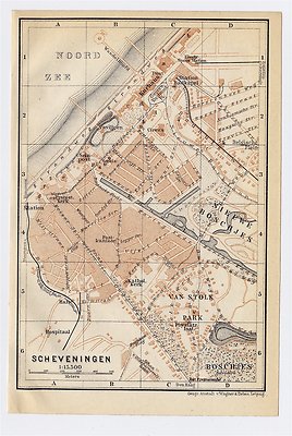
$5.00 Shipping Location: Canada 1910 ANTIQUE CITY MAP OF SCHEVENINGEN/ THE HAGUE DEN HAAG/ HOLLAND NETHERLANDS This original antique map gives you an opportunity to examine in exquisite ... moredetail a piece of history. Once matted and framed. This map would make a perfect gift for a family member or friend they'll cherish forever. Origin of the map: Belgium and Holland" 15th edition, published in Leipzig, Germany by Karl Baedeker, London, T. Fisher Unwin and New York, Charles Scribner's Sons. Date of issue: 1910 Size: The sheet measures: 6" x 4" 15 x 10 cm) S/H: The map will be shipped by Air Mail. The shipping charge is: USA- 2.00 USD. World- 4.00 USD, Canada- 1.00 USD. The price includes a strong and secure envelope. Attention! We combine shipping costs for multiple items. The HIGHEST VALUE SHIPPING FEE WILL APPLY FIRST and each subsequent item will be shipped FOR FREE. Pay me securely with any major credit card through PayPal! Payment methods: US/Canada Buyers: Paypal. International Buyers: Paypal. Click Here. Double your traffic. Get Vendio Gallery- Now FREE! G.RcmdId ViewItemDescV4,RlogId p4%60bo7%60jtb9%3Fuk%601d72f%2Bjw%60hquvg%3Eg-13d6dd6aa2c-0xf9-
$15.16 Shipping Location: PETERBOROUGH, United Kingdom Ordnance Survey 1" Third Edition District Map of Dorking and Leith Hill District
Buy It Now
$13.60 Shipping Location: Granger, United States The intricate details of the city and surrounding areas were engraved using copper plates and hand-colored for added vibrancy. This piece is an original ... moreantique and is in excellent condition.
Buy It Now
$6.95 Shipping Location: Dover, United States Issued 1711, London by Cluverius. Bottom blank margin is very narrow, lower left blank margin nicely extended with near matching old paper in order to ... morefacilitate matting and display of the map. Early 18th century engraved map with lovely hand color.
Buy It Now
$18.00 Shipping Location: Rockville, United States By Mapmaker, Pierre Francois Tardieu. His uncle taught him the art of engraving and he produced many historical and genre works. Published Circa: 1790 ... more- OVER 225 YEARS OLD! - NOTE: The map is in French and it is unfolded.
$17.98 Shipping Location: BEXHILL-ON-SEA, United Kingdom SOUTH ORKNEY ISLANDS -. ADMIRALTY CHART. THIS PUBLISHED AT THE ADMIRALTY 1934. FROM FAMILY IN ADMIRALTY. ANTARCTIC OCEAN. DATED 1933. THE CHART DETAILS ... moreINCLUDE ALL ORIGINAL, FOLDED, SMALL TEARS ON FOLDS.
Buy It Now
$33.19 Shipping Location: FALKIRK, United Kingdom The map is generally in good condition (see photos). It is ideal for framing and would be of interest to local historians/collectors.
Buy It Now
$13.29 Shipping Location: GLASGOW, United Kingdom Plan of St Andrews - Published by John Bartholomew. Based on plan prepared by the Burgh Engineer and reproduced with permission and by the courtesy of ... moreSt Andrews Town Council.
Buy It Now
$29.10 Shipping Location: FALKIRK, United Kingdom The map is generally in good condition although has a few small tears around the edges (see photos). It is ideal for framing and would be of interest ... moreto local historians/collectors.
Buy It Now
$29.10 Shipping Location: FALKIRK, United Kingdom It is ideal for framing and would be of interest to local historians/collectors.
Buy It Now
$28.88 Shipping Location: FALKIRK, United Kingdom The map has several small tears around the margins and a section towards the top left is missing (see photos). It is ideal for framing and would be of ... moreinterest to local historians/collectors.
Buy It Now
$6.95 Shipping Location: Dover, United States Plan of Cardona, A Strong City and Castle of Catalonia Upon the River Cardoner as Besieged by the French and Defended by the Allies. Large mid 18th century ... moreengraved map. Explanation key at top left identifies over 2 dozen specific features.
Buy It Now
$28.67 Shipping Location: FALKIRK, United Kingdom It is generally in a reasonable condition, although has a number of small tears around the edges (see photos). It is ideal for framing and would be of ... moreinterest to local historians/collectors.
Buy It Now
$5.95 Shipping Location: Avondale, United States Copperplate engraving is printed on one side of the paper. Blank on the back. This rare piece was removed from an 1797 encyclopaedia britannical dictionary ... moreof the arts, sciences, and miscellaneous literature.
Buy It Now
Free Shipping Location: Pen Argyl, United States The map is considered quite rare and is well suited for antique enthusiasts. Get your hands on this rare piece and add it to your antique collection.
$15.02 Shipping Location: BEDFORD, United Kingdom In good condition.
$18.83 Shipping Location: WINCHESTER, United Kingdom 1780 original antique copper plate map, outline hand colour with fold as issued.
Buy It Now
$30.00 Shipping Location: Cooks, United States Antique Mid 1600's John Speed Original hand colored authentic map. This is an incredible framed map. It was originally sold from Richard Nicoleson of ... moreChester. And it has their guarantee coa still on the back. It is such a beautiful well preserved piece! Let me know if you have any questions
Buy It Now
$16.99 Shipping Location: LONDON, United Kingdom Year - around 1720. Hand Coloured copper engraving. For sale Geographical Presentation of the Kingdoms of Poland.
Buy It Now
$15.55 Shipping Location: Saint Charles, United States Nice vintage map. I don’t see a date. I’d guess the 1940s or so but I’m not sure. It was a library check out and has a card catalog card and some writing. ... moreVery good condition with no tears and minimal staining/discoloration.
Buy It Now
$24.05 Shipping Location: Norristown, United States This old engraved and hand colored map is Sr. Christopher Wren's Plan For Rebuilding The City Of London After The Dreadful Conflagration In 1666 and is ... moremarked at the top - Engraved For Chamberlain's History of London.
Buy It Now
Free Shipping Location: Columbus, United States Fits model(s): YF21-SD_TW.
9d 23h 10m 24s 0 bids
$8.78 Now
$15.90 Shipping Location: ALNWICK, United Kingdom Edition: Third. Published in 1930. Minor corrections 1929. In the mid 1920s the original third edition sheet lines were revised and sheet 8A was one of ... morethe sheets published on new sheetlines. The map is in excellent condition, unmarked and with no wear on the dissections or cloth backing.
Buy It Now
$9.20 Shipping Location: Poland Size: 17,12" x 20,66" (43,5cm x 52,5cm).
Buy It Now
$15.06 Shipping Location: United Kingdom
Buy It Now
$7.75 Shipping Location: Montrose, United States Year of Publication: 1871.
Buy It Now
$19.00 Shipping Location: Ukraine
Buy It Now
$6.95 Shipping Location: Dover, United States Issued 1673, Vienna by Gualdo Priorato. Fine late 17th century folio engraved plan of this French commune. With beautiful full hand color which greatly ... moreenhances the visual appeal of the map. Clean and well-preserved overall, still an entirely pleasing example of this 17th century Dutch city plan which will look lovely if displayed.
Buy It Now
$6.95 Shipping Location: Dover, United States Issued c. 1850's, Germany by Heck. Engraved by R. Schmidt. Remarkably detailed mid-19th century engraved city plan map with attractive hand color. Paris ... moreAls Waffenplatz.
Buy It Now
$9.20 Shipping Location: Poland Size: 16,73" x 14,17" (42,5cm x 36cm).
Buy It Now
Free Shipping Location: Brooklyn, United States Up for grabs today is a Brand New- Miss Peregrine Book Series Map Of Devil's Acre. Item is brand new and kept in a smoke free, pet free environment. Item ... moreis shipped via USPS first class mail. Please view all pics and bid with confidence.Measurements 11” x 14”
Buy It Now
$8.60 Shipping Location: Knoxville, United States This beautiful wall map depicts the member states of the European Union as of 2013. The poster measures 21x20 inches and features a contemporary design. ... morePerfect for political enthusiasts, this map provides a detailed view of Europe and its member countries.The map is in excellent condition and is a great addition to any collection. It is a wonderful educational tool for those interested in European geography and politics. Don't miss out on the opportunity to own this stunning piece of cartography.
Buy It Now
$26.89 Shipping Location: PICKERING, United Kingdom Hardcover Pocketbook. Pocketbook size = approx 16.5cm x 12cm x 1cm. The map covers England and Wales and is in lovely condition for its age. There are ... moreno tears along the folds or edges of the map. A few wrinkles in the cloth and 3 small holes on the folds that you can see when held up to the light.
Buy It Now
$10.07 Shipping Location: Plano, United States Any additions or corrections are appreciated. Fotos are of the actual item you shall receive.
Buy It Now
$6.50 Shipping Location: Belton, United States Original 1866 Map of Lower Italy Color Atlas Map Engraved Lithograph Map Hand Colored Printed in Paris Wall Art Decor Print Wall Hanging. Published in ... moreParis, France by L. Hachette. From the atlas; "Atlas Universel D'Histoire et de Geographie" (Atlas of Universal History and Geography) by M.N. & P. Bouillet.
$26.47 Shipping Location: CANTERBURY, United Kingdom Includes a silk local planning type map. I've not checked them all in detail so condition will be variable.
Buy It Now
$7.75 Shipping Location: McAdoo, United States A. T. Holman & Co. From a 1898. 1-The Holy Land. Family Bible. Lot of Eight. On Four Pages. History of the Patriarchs. 3-Modern Egypt.
$17.68 Shipping Location: STOCKPORT, United Kingdom
$17.68 Shipping Location: STOCKPORT, United Kingdom
Buy It Now
$15.71 Shipping Location: NORWICH, United Kingdom c.1980s Barnett's Street Map of NORWICH. Includes detailed plans and street maps of Old and New Costessey, Cringleford, Hellesdon, Old Catton, Eaton, ... moreKeswick, Trowse, Thorpe End, Thorpe St Andrew, Norwich Airport, city centre. Sent within one working day of purchase.
Buy It Now
$14.57 Shipping Location: NORWICH, United Kingdom A fully laminated off road map of the Weymouth Valley and Arun Link at Guildford and Godalming areas featuring bridleways, footpaths, and quiet roads, ... moreideal for walking, cycling, riding. Designed for use in the field. Shows heights, steepness, problems. Notes on track conditions. Route suggestions. Indestructible and weatherproof. Ideal for route planning. Licensed by the Ordnance Survey. Sent within one working day of purchase.
$16.15 Shipping Location: WIRRAL, United Kingdom Covers are slightly browned.

Buy It Now
$10.04 Shipping Condition: Unspecified Location: LONDON, United Kingdom Maltese Islands; Gibraltar; Strait of Gibraltar; Cyprus; Channel Islands; Inset map Guernsey; Alderney; Jersey; Sark Vintage colour map; Scale 1:950.000; ... moreScale 1: 63,360; Scale 1: 475,000; Scale 1: 860,000; Scale 1: 1,500,000, 1920 Title of map: Maltese Islands; Gibraltar; Strait of Gibraltar; Cyprus; Channel Islands; Inset map Guernsey; Alderney; Jersey; Sark' The image below shows an enlarged cross section from the centre of the map to show the level of printed detail: DATE PRINTED: 1920 IMAGE SIZE: Approx 33.0 x 22.0cm. 13 x 8.5 inches(Large) ARTIST/CARTOGRAPHER/ENGRAVER: Unsigned PROVENANCE: Harmsworth's new Atlas" TYPE: Vintage colour map; Scale 1:950.000; Scale 1: 63,360; Scale 1: 475,000; Scale 1: 860,000; Scale 1: 1,500,000 VERSO: There are images and/or text printed on the reverse side of the picture. In some cases this may be visible on the picture itself(please check the scan prior to your purchase) or around the margin of the picture CONDITION: Good; suitable for framing. Please check the scan for any blemishes prior to making your purchase. Virtually all antiquarian maps and prints are subject to some normal aging due to use and time which is not obtrusive unless otherwise stated. I offer a no questions asked return policy- see below. AUTHENTICITY: This is an authentic historic print. Published at the date stated above. I do not offer reproductions. It is not a modern copy. The term'original' when applied to a print means that it was printed at the first or original date of publication; it does not imply that the item is unique. Print' means any image created by applying an inked block to paper or card under pressure by any method including wood engraving, steel engraving, copperplate, wood cut and lithography. REMARKS: FRANCE: Gravures et Cartes anciennes. DEUTSCHLAND: Alte Lankarten und Stadt ansichten. ITALIA: Stampe e Mappe antiche. ESPAÑA: Mapas antiquos y impresiones antiguas. E and OE. Force Majeure. English law shall apply. RETURNS POLICY: I offer a no questions
Buy It Now
$31.37 Shipping Location: ANDOVER, United Kingdom Ordnance Survey. London: Ordnance Survey, 1882 Early Edition, Large Map (approx. London: Ordnance Survey. Publication Date: 1882. Sheet No 302. [Folded ... moreLinen Backed Card]. Colour, with coloured borders. ).
$16.06 Shipping Location: WIRRAL, United Kingdom Map is in very good condition as are covers and guide.
$15.46 Shipping Location: CARDIGAN, United Kingdom A New Map Of The County Of Suffolk Divided Into Hundreds. Complete with a worn, but still serviceable, marbled slip-case with original paper title in ... moresound unrepaired condition. A surprising early and relatively unscathed linen-mounted folding map with an attractive vignette of.
Buy It Now
$98.73 Shipping Location: Connersville, United States This world map is masterfully crafted and of particular interest to anyone interested in antique maps. With a date range of 1600-1699, it is a fantastic ... morerepresentation of the world during that time. The map is divided into two planes and is titled 'Orbis Terraum Descriptio Duobis Planis Hemisphaeriis Comprehesa Map.' It is a world map and is sure to delight any history enthusiast interested in antique maps.
Buy It Now
$6.95 Shipping Location: Dover, United States Issued 1874, Edinburgh by A. & C. Black. Uncommon 19th century lithographed city plan with original hand color. (Ireland). Original fold lines as issued, ... moreclean example, a couple short clean splits along fold lines nicely closed on reverse with small pieces of archival tape and all but invisible when viewing this charming little map.

Buy It Now
$11.00 Shipping Location: Rockville, United States Fine Adornment of European History. Creative& Imaginative Gift 1846 Goodrich Map Spain& Portugal Hand-Colored. Intricate Engraved Detail. Fine ... moreSamuel Goodrich Map. Engraved by G.W. Boynton. Original 1846. 168-yrs-old. Map is in Fair/Good Condition: No folds or writings. Mild foxing. Nominal fraying. Some bleed from opposing page. Not a Reproduction. Original Map Engraved by G.W. Boynton for the 1846 Edition of The Book of History Combined with Geography. Comprising the History and Geography of The Western Hemisphere; Samuel Goodrich, Published by Jenks, Hickling, Swan, Boston, 1846; a copy of the Title Page of which is Included. Handsome Adornment of History. Steel-Plate Engraved. Hand-Colored. I sell only Original Maps: No copies or reproductions. Press Here View My Collection. Impressive on Any Home or Office Wall Dimensions: 5 1/4" x 7" Fine Adornment of Spanish& Portuguese History. The Auction is for the Map Itself. A Frame is Not Included. The Framed Map Pictured is a Personal 1846 Goodrich Map Featured to Show the Beauty when Framed. Free Shipping Special(within the USA) All credit cards. Debit cards, electronic checks accepted through Paypal. Maps are mailed within 1-3 days of payment and normally arrive within 3-5 days. Please email with any questions. Imaginative& Creative Gift. Greetings from Historical Savannah. Georgia; founded 1733. Some. To beautify their halls, chambers, studies, or libraries.loveth, getteth, and useth maps, charts, and geographical globes. John Dee, Advisor to Elizabeth I. Press The Link Below To View My Collection. Powered by The free listing tool. List your items fast and easy and manage your active items.
|
|
|
|
GREECE CRETE Spinalonga Isl. Portolanos map, Roux 1764
GREECE CRETE Spina Longa Island Portolanos map FROM: Recueil Des Principaux Plans des Ports et Rades de la Mer Méditerranée. Estraits de ma Carte en Douze Feuilles By Joseph Roux. Marseille. 1764. First edition(the best. See front page) A strongly impressed copper engraved portolanos map. On handmade heavy paper, watermarked with horizontal lines. Image size: 192 x 123 mm Plate size: 207 x 139 mm Sheet size: 230 x 174 mm Very good condition. Small stain at upper right. Not affecting the image. Worldwide combined registered shipping: $6(paid once. For as many maps) Please see my other 11 Roux Portolanos maps on Greece. From the same Atlas.
|
|
|
Germany Divided Provinces Circles c.1750 antique engraved map
Germany Divided Provinces Circles c.1750 antique engraved map Allemagne Divisee par Cercles(Germany) Issued c.1750. Paris by Vaugondy Fine original antique engraved map. Printed in the 18th century, on quality paper which retains its inherent structural flexibility and soundness. With beautiful hand color. In near VG or better condition. Light minor age wear, overall very presentable and attractive[note: we grade very conservatively and always seek to disclose any noteworthy flaws] The printed area remains visually pleasing. A nice impression of an interesting antique map which will look nice when displayed. Original fold-lines as issued. Sheet measures c. 6 3/8" H x 6 7/8" W. Printed area measures c. 5 1/2" H x 5 3/4" W. 31293] Any defects along the sheet edges and in the margins may be seen in the photos. note: All old ... moresheets of printed paper possibly have short edge splits. Each sheet has existed for a very long time and has probably been handled repeatedly in the course of it's existence. It has a history unique to it as an object. Most of the time any edge splits are short. Minor, insignificant and have been closed- either long ago or more recently with small pieces of archival tape. Most often these splits are trivial and easy to overlook visually. Basically, they would not significantly affect the piece adversely. The item is offered as seen. Please look carefully and make your decision knowing this antique image is nice. But it is not in perfect"like new" condition. However, with whatever flaws it possesses, it remains entirely worthy of ownership and inclusion in any related collection. We feel it will prove very pleasing to its new owner. We stand behind everything we sell. Everything we offer is guaranteed to be an authentic original antique item as described. We do not sell modern reproductions. Please visit our. We happily accept PayPal! WE OFFER FLAT RATE SHIPPING WORLD WIDE! Please request
|
|
|
Bergen-Op-Zoom Holland Netherlands 1780 antique city map plan Lillo detailed
Bergen-Op-Zoom Holland Netherlands 1780 antique city map plan Lillo detailed A New and Exact Plan of the Town and Fortifications of Bergen-Op-Zoom. With the adjacent Forts(Holland/ Netherlands) Issued London. C. 1780 by James MacGowan. Nice. Well-preserved late 18th century engraved map/ plan of this Dutch city and its fortifications. Nicely detailed. In near VG. Mostly clean condition. Map gently toned with some scattered light spotting- hardly offensive- but otherwise clean and quite well-preserved overall. Sheet measures c. 10 1/2" W x 8" H. Engraved area measures c. 8 1/2" W x 6 1/2" H. 5808] Any defects along the sheet edges and in the margins may be seen in the photos. note: All old sheets of printed paper possibly have short edge splits. Each sheet has existed for a very long time and has probably been handled repeatedly ... morein the course of it's existence. It has a history unique to it as an object. Most of the time any edge splits are short. Minor, insignificant and have been closed- either long ago or more recently with small pieces of archival tape. Most often these splits are trivial and easy to overlook visually. Basically, they would not significantly affect the piece adversely. The item is offered as seen. Please look carefully and make your decision knowing this antique image is nice. But it is not in perfect"like new" condition. However, with whatever flaws it possesses, it remains entirely worthy of ownership and inclusion in any related collection. We feel it will prove very pleasing to its new owner. We stand behind everything we sell. Everything we offer is guaranteed to be an authentic original antique item as described. We do not sell modern reproductions. Please visit our. We happily accept PayPal! WE OFFER FLAT RATE SHIPPING WORLD WIDE! Please request an invoice before paying for multiple items so that we can ensure that you are not overcharged for shipping! To receive our flat r
|
|
|
Austria Hungary Budapest Transylvania 1895 Stieler antique engraved color map
Austria Hungary Budapest Transylvania 1895 Stieler antique engraved color map OSTERREICH_UNGARN IN 4 BLATTERN. Austria Hungary) Issued 1895. Gotha Germany by Perthes for Stieler. Fine antique engraved map. With original outline hand color. Made approximately 115 years ago. Printed in the late 19th century, on quality paper which retains its inherent structural flexibility and soundness. A beautifully engraved and very detailed map of this region. With a profusion of details not often seen. The key identifies dozens of detailed tracks of explorers, each labelled with precision. In near VG or better condition. Short split to bottom centerfold mended on back with archival tape[note: we grade very conservatively and always seek to disclose any noteworthy flaws] The printed area remains visually pleasing, a nice impression of an interesting map. ... moreSheet measures c. 18 3/4" W x 15" H. Engraved area measures c. 15 3/4" W x 13" H. 11116] Any defects along the sheet edges and in the margins may be seen in the photos. note: All old sheets of printed paper possibly have short edge splits. Each sheet has existed for a very long time and has probably been handled repeatedly in the course of it's existence. It has a history unique to it as an object. Most of the time any edge splits are short. Minor, insignificant and have been closed- either long ago or more recently with small pieces of archival tape. Most often these splits are trivial and easy to overlook visually. Basically, they would not significantly affect the piece adversely. The item is offered as seen. Please look carefully and make your decision knowing this antique image is nice. But it is not in perfect"like new" condition. However, with whatever flaws it possesses, it remains entirely worthy of ownership and inclusion in any related collection. We feel it will prove very pleasing to its new owner. We stand behind everything we sell. Everything we offer is guaranteed to be an authentic original antique item as described. We do not
|
|
|
Russia in Asia Siberia by Meyer c.1858 antique engraved map
Russia in Asia Siberia by Meyer c.1858 antique engraved map Das Asiatische RUSSLAND 1855(Russia in Asia) Issued Germany: c. 1858; for Meyer. Fine original antique engraved map. Made approximately 160 years ago. Printed in the mid-19th century in Germany, on quality paper which retains its inherent structural flexibility and soundness. With original outline hand color. Meyer maps are noteworthy for their precise engraving technique and the profusion of countless place names. In VG or better condition[note: we grade very conservatively and always seek to disclose any noteworthy flaws] The printed area remains visually pleasing. A nice impression of an interesting antique map. Any minor defects along the sheet edges and in the margins may be seen in the photos. Original fold line as issued. Sheet measures c. 11 3/8" W x 9 1/4" H. Engraved ... morearea measures c. 10 1/8" W x 7 3/4" H. 15264] note: All old sheets of printed paper possibly have short edge splits. Each sheet has existed for a very long time and has probably been handled repeatedly in the course of it's existence. It has a history unique to it as an object. Most of the time any edge splits are short. Minor, insignificant and have been closed- either long ago or more recently with small pieces of archival tape. Most often these splits are trivial and easy to overlook visually. Basically, they would not significantly affect the piece adversely. The item is offered as seen. Please look carefully and make your decision knowing this antique image is nice. But it is not in perfect"like new" condition. However, with whatever flaws it possesses, it remains entirely worthy of ownership and inclusion in any related collection. We feel it will prove very pleasing to its new owner. We stand behind everything we sell. Everything we offer is guaranteed to be an authentic original antique item as described. We do not sell modern reproductions. Please visit our eBay Store. We happily accept PayPal!
|
|
|
Bas-Rhin France 1835 original antique engraved map with vignette
Bas-Rhin France 1835 original antique engraved map with vignette FRANCE PITTORESQUE BAS RHIN issued Paris: 1835 Fine original antique engraved map of this French region. With appealing vignette view, printed in the early-19th century on quality paper which retains its inherent structural flexibility and soundness. In Very Good or better condition[note: we grade very conservatively and always seek to disclose any noteworthy flaws] The printed area remains pleasing. A nice impression that would look great framed. Sheet measures c. 7" W x 10 7/8" H. Engraved area measures c. 5" W x 7" H. 23091] note: All old sheets of printed paper possibly have short edge splits. Each sheet has existed for a very long time and has probably been handled repeatedly in the course of it's existence. It has a history unique to it as an object. ... moreMost of the time any edge splits are short. Minor, insignificant and have been closed- either long ago or more recently with small pieces of archival tape. Most often these splits are trivial and easy to overlook visually. Basically, they would not significantly affect the piece adversely. The item is offered as seen. Please look carefully and make your decision knowing this antique image is nice. But it is not in perfect"like new" condition. However, with whatever flaws it possesses, it remains entirely worthy of ownership and inclusion in any related collection. We feel it will prove very pleasing to its new owner. We stand behind everything we sell. Everything we offer is guaranteed to be an authentic original antique item as described. We do not sell modern reproductions. Please visit our. We happily accept PayPal! WE OFFER FLAT RATE SHIPPING WORLD WIDE! Please request an invoice before paying for multiple items so that we can ensure that you are not overcharged for shipping! To receive our flat rate shipping rates you must request or wait for an invoice. We can no longer refund excess s
|
|
|
WAR OF THE ROSES, ENGLAND 1455-1485 ,ANTIQUE COLOUR MAP
WAR OF THE ROSES. ENGLAND 1455-1485 TYPE: COLOUR MAP SHOWING ENGLAND DURING THE WAR OF THE ROSES 1455-1485 COUNTRY/CONTINENT: ENGLAND DATE: 1455-1485 PUBLISHED DATE: 1899 ARTIST/CARTOGRAPHER/ENGRAVER: F.S. WELLER F.R.G.S CONDITION: VERY GOOD VERSO: BLANK TO REVERSE SIZE(approx) 10cms x 14cms(small) Perfect for framing a little piece of the past. Always refer to sizing above for measurements All maps are originals and not photocopies and in some cases may have discolouring due to age. The word original does not make this item unique. Please check individual details for each plate. All maps have been carefully saved and removed from a heavily damaged book. Where possible all explanatory text has been left intact adding to the interest of the print. Maps have been trimmed to obtain straight edges in most cases leaving room for further cropping ... moreif required N.B. All maps have been removed from books/periodicals/atlases and are single pages unless stated otherwise All maps are sent out in film front bags and cardboard backed envelopes. POSTAGE FREE WORLDWIDE DELIVERY! Paypal payment only We post within 1 business day of cleared payment usually same business day if payment has cleared by 1.00pm. We always obtain proof of posting We value positive feedback so in the unlikely event of any problems after sale. Please let me know before leaving negative or neutral feedback and we will do our best to rectify the problem. Please see my! Powered by
|
|
|
1901 ANTIQUE MAP OF MEXICO
1901 COLORFUL MAP OF MEXICO This original antique map gives you an opportunity to examine in exquisite detail a piece of history. If you are interested in the past of this country and its people or have a desire to study where your family may have come from. Then this map gives you a rare look as the area was about 100 years ago. Once matted and framed, this map would make a perfect gift for a family member or friend they'll cherish forever. Origin of the map: Rand. McNally& Co.S"The World and its Peoples" published in Chicago, USA. Date of issue: 1901 Size: The sheet measures 14" x 10 1/2" 35 x 26 cm) MINOR REPAIRS ON BACK. S/H: The map will be shipped by Air Mail. The shipping charge is: USA- 7.50. World/Canada- 8.50. The price includes the insurance and a strong, cardboard tube with plastic plugs. Attention! ... moreThere is no additional shipping charge for multiple purchases! Pay me securely with any major credit card through PayPal! Payment methods: US/Canada Buyers: Paypal. International Buyers: Paypal. Click Here. Double your traffic. Get Vendio Gallery- Now FREE!
|
|
|
Genuine Antique map of Scandanavia - Sweden, Norway & Finland. A.M. Mallet, 1683
Genuine Antique map"Svede" from Description de l'Univers by Alain Manesson Mallet. Paris, 1683. This bold copperplate map shows Norway, Sweden, Finland and Denmark with nice detail of waterways, lakes and coastlines. Ships sail the seas. The title is shown in a elaborate cartouche with crown and flags. Print is in very good condition. Image measures 5 3/4"x 4" THIS IS NOT A REPRODUCTION! All of our items are genuine antiques as described.
|
|
|
ANTIQUE 1834 MAP TURKEY IN EUROPE WALACHIA BOSNIA SERBIA MACEDONIA MOREA & MORE
Original Antique Map 1835 Turkey in Europe Anadolia. Constantinople, Morea, Aidin, Hamid and more Published by J Lothin Edinburgh 1 March 1834 Condition: corner and edging rub. Paper aged upper surround edge rough. This may have come out of a book tear to the left hand side near the top of the surround the edges are not as dark as the picture makes the look Size: ca 45 x 33 cm If you have any questions please do not hesitate to contact me Will be posted in protective packaging All items are covered for up to £46.00 anything selling above this will have insured and signed for added to the invoice. In this instance please wait for the invoice. Please note that the buyer is responsible for any customs charges incurred. Please note should you not be entirely satisfied I will give a full refund once the item is returned in it's original ... morecondition and having been checked for my security markings. I cannot give partial refunds. Please note that I cannot guarantee that this items comes from a pet free or smoke free home
|
|
|
1787 Colorful Bonne Map of Ancient Spain, Portugal and Balearic Islands
17 87 Rigobert Bonne Map- Hispana Vetus" Rigobert Bonne. As Royal Hydrographer to the French navy was prima rily concerned with the production of marine charts. However. He is sued many other types of maps including those of an historical nature. This copperplate map is a fine example. The map s hows Spain. Portu gal and the Balearic Isl ands during the the time of the Roman Empire. Condition: Excellent. Engraved on hand laid heavy paper with modern c oloring. Centerfold(as issued) Bonne's name appears at bottom right. Dimensions: 3 50 x 240mm; 1 3.5 x 9. 0 inches. Good margins all round. The map is guaranteed to be over 2 0 0 years old. Shipping United States- Regular Airmail US$4.50. Registered/insured airmail(optional) is an additional US$12.00 for a total of US$16.50. Canada- US$3.00 for regular mail. US$9.00 for registered mail. ... moreRest of the World- Regular airmail US$8.00. Registered/insured airmail(optional) is an additional US$12.00 for a total of US$20.00
|
|
|
1821 ORIGINAL Map of Prussia, Poland, Germany, Berlin, Danzig, Russia
Original hand colored engraving as issued. Blank on verso. Dated in the plate. Engraved by Cooper. Published by Sherwood. Neely& Jones. Image area is 9.5" w by 7.5" h. Interesting and detailed map extending from Maestricht to Grodno and from the Gulf of Danzig to the Vistula River. Centers on Berlin. Beautifully executed. Attractive hand color,will frame nicely. Overall good condition with moderate ageing. Low starting bid with no reserve. Postage charge is for domestic insured priority mail.
|
|
|
EUROPE ICELAND NORWAY RUSSIA GERMANY ITALY GREECE ENGR. MAP HOMANN 1716 #A915S
1* Take advantage of the offer of rare prints and books as a crisis-resistant and stable value investment at reasonable prices! Nutzen Sie das Angebot von seltenen Graphiken und Büchern als krisenbeständige und stabile Wertanlage zu vernünftigen Preisen! Decorative and large-size old-coloured copper engraving map. Published by Johann Baptist Homann, out of the Atlas: Grosser Atlas Uber die Gantze Welt. Wie diese sowol Nach Göttlicher Allweisen Schöpffung aus den heutigen Grund-Sätzen. zu betrachten" printed Nuremberg, 1716 AD Map of the continent Europe"Europa Christiani. Cartographer: Johann Baptist Homann( 20 March 1664 in Oberkammlach near Kammlach. Bavaria; 1 July 1724 in Nuremberg, was a geographer and cartographer, who made atlases and maps. Description We offer a Original and old-coloured copper ... moreengraving map by J. B. Homann. This detailed map shows the continent of Europe with the Christian countries of Scandinavia. Great Britain, Ireland, Germany, France, Portugal, Spain, Italy, Poland, Greece an other as well asdjacent areas. The map is decoratred with a beautiful title cartouche. The map is a wonderful collection item! Size: Leaf app. 58.9 x 55,3 cm Map app. 57.7 x 49,2 cm Condition: good condition strong print slightly brownish and stained complete restored center fold Please have a look at the pictures! We offer only Originals. No Reproductions! Dekorative und Großformatige altkolorierte Kupferstichkarte. Herausgegeben von Johann Baptist Homann aus dem Atlas: Grosser Atlas Uber die Gantze Welt. Wie diese sowol Nach Göttlicher Allweisen Schöpffung aus den heutigen Grund-Sätzen. zu betrachten" gedruckt in Nürnberg, 1716 AD Karte vom Kontinent Europa"Europa Christiani. Kartograph: Johann Baptist Homann( 20. März 1664 in Oberkammlach. Heute Teil von Kammlach im Landkreis Unterallgäu; 1. Juli 1724 in Nürnberg) war ein deutscher Kartograph. Verleger und Kupferstecher. Be
|
|
|
1854 Mitchell Map of Russia in Asia and Tartary
1854 Mitchell Map of Russia in Asia and Tartary WE SELL ONLY ORIGINAL ANTIQUE MAPS- NOT REPRODUCTIONS Title: Russia in Asia and Tartary. Description: A fine example of Thomas Cowperthwait and S. A. Mitchell’s 1854 map of Russia in Asia and Independent Tartary. Also includes parts of the adjacent Chinese Empire. Korea, and Japan. Identifies the disputed sea between Japan and Korea as the“Sea of Japan” The whole is engraved in Mitchell’s distinctive style with green border work and vivid pastels. Political and topographical features are noted and color coded with elevation rendered by hachure. This map was prepared by S. A. Mitchell for publication by the Philadelphia firm of Thomas Cowperthwait& Co. as plate no. 65 in the 1854 edition of Mitchell’s New General Atlas. Dated and copyrighted, Entered according to act of Congress in the year ... more1850 by Thomas Cowperthwait& Co. in the Clerk's office of the Eastern District of Pennsylvania. Size: Printed area measures 12 inches high by 15 inches wide. Condition: Very good condition. Blank on verso. Shipping: Items are shipped within three business days of receiving payment. We are happy to consolidate shipping where possible. The following shipping options are available: 1. USPS Domestic Express Mail(25 USD) USA Only. 2. USPS Priority Mail(12 USD) USA Only. 3. USPS International Express(35 to 55 USD) Recommended service for all international parcels. 4. USPS Priority Mail(25 USD) Available to only certain countries. Due to high instances of loss. This service is specifically NOT AVAILABLE to MAINLAND CHINA or INDIA. 5. Federal Express is available upon request. This is the only service option available to India and Africa. Price is quoted upon request following the auction. We can also use your Federal Express Account. Insurance: All shipments are insured privately against loss and damage. All of our shipments require a signature. If you have any questions please feel free to email us through eBay or contact us by telephone at 646-320-8650. Additional Servi
|
|
|
18TH CENTURY TRAVELER’S MAP OF EUROPE – Superb – 1780 Handcolored in Portfolio
F-159 PLEASE SEE OUR OTHER LISTINGS. For 100s more Antiquarian Items. US and INTERNATIONAL CUSTOMERS SHIPPING Please Note: Because we ship from Europe. For some items(books) the automatic eBay shipping calculator includes only the price for government rate surface mail in the listing, is extremely slow. Rates for airmail range from just a few dollars for under 500g(1.1 lbs) packages, to almost $90 for a big 20kg(44 lbs) box. Unfortunately there is no way for us to include prices for airmail delivery in the eBay shipping calculator. We wish we could! Please contact at any time for an exact quote for airmail, the packed weight of each item appears at the end of the item description. We charge only for postal costs corresponding exactly to current German postal rates, we do not charge any additional fee for packing or handling. Powered by The ... morefree listing tool. List your items fast and easy and manage your active items.
|
|
|
1625 Daniel Meisner Panorama Town View GENDT Netherlands Engraving
An original copper engraving by Daniel Meisner(Meissner) 1585-1625on laid paper. Titled in Latin- NULLUS THESAURIUS AT USUS" 1625 In the upper part of the engraving gendt- a Netherlands city. On the bottom more Latin text translated to German- and a bizarre Medieval scene Plate mark impression size 15 x 9.5 cm. Total paper size 17 x 11.5 cm. Very good condition- Sharp impression with some bent signs. Meisner's emblem book. Containing over 800 pictorial-poetic compositions, was enormously popular throughout Europe in the 17th century. The plan views were based on the work of De Bry, Braun& Hogenberg, Merian and others with the addition of emblematic figures or scenes in the foreground, juxtaposed with moralizing and edifying verses beneath the image and a Latin motto at top. It was originally issued with 52 plates as the Thesaurus ... morephilo-politicus in 1623-24. After Meisner's death in 1625. Eberhard Kieser, with assistance from Johann L. Gottfried, completed the work and published it until 1631. The plates then appeared in the eight parts of Sciographia Cosmica published by Paulus Furst between 1637-78. This plate is an early one- not numbered yet. Payment by Paypal. Shipping& Handling: $12.00 worldwide by registered airmail post
|
|
|
1727 Amsterdam Netherlands MAP Repo, City View, Directory, QUALITY, Ships, Pics
1727 Amsterdam MAP* Detailed survey with directory HIGH QUALITY GICLEE REPRODUCTION Great addition to your home decor. The size of this map is. 15" x 12.75" THIS IS AN EXACT REPRODUCTION DIRECTLY FROM THE ORIGINAL SOURCE We use archival quality papers and ink Looks amazing framed! All prints are delivered in a heavy duty poster tube for safe delivery. Customer satisfaction guaranteed! If for some reason you want to return the item. Or your print is damaged, you can return for a full refund no worries. AMSTER WE SHIP ITMES OUT FAST If it's ordered by 11AM Pacific. We ship it same day:
|
|
|
Kingdom of Spain Portugal c.1780 Bonne antique map
Kingdom of Spain Portugal c.1780 Bonne antique map Le ROyaume d'Espagne et Celui de Portugal Issued c.1780's. Paris by R. Bonne Engraved by Andre. Fine original antique engraved map. Printed in the late 18th century, on quality hand-made paper which retains its inherent structural flexibility and soundness. In near VG or better condition. Light minor age wear, light toning to sheet, but overall very presentable and attractive[note: we grade very conservatively and always seek to disclose any noteworthy flaws] The printed area remains visually pleasing. A nice impression of an interesting antique map which will look nice when displayed. Sheet measures c. 11 1/4" H x 16" W. Printed area measures c. 9 1/4" H x 13 1/2" W. Original fold line as issued. 27296] Any defects along the sheet edges and in the margins may ... morebe seen in the photos. note: All old sheets of printed paper possibly have short edge splits. Each sheet has existed for a very long time and has probably been handled repeatedly in the course of it's existence. It has a history unique to it as an object. Most of the time any edge splits are short. Minor, insignificant and have been closed- either long ago or more recently with small pieces of archival tape. Most often these splits are trivial and easy to overlook visually. Basically, they would not significantly affect the piece adversely. The item is offered as seen. Please look carefully and make your decision knowing this antique image is nice. But it is not in perfect"like new" condition. However, with whatever flaws it possesses, it remains entirely worthy of ownership and inclusion in any related collection. We feel it will prove very pleasing to its new owner. We stand behind everything we sell. Everything we offer is guaranteed to be an authentic original antique item as described. We do not sell modern reproductions. Please visit our. We happily accept PayPal! WE OFFER FLAT RATE SHIPPING
|
|
|
HOLLAND, TALLIS, 1851
TALLIS MAP OF HOLLAND. CIRCA 1851. DRAWING BY J. RAPKIN. VIEWS ENGRAVED BY J. B. ALLEN. 14" X 10.75" MAP WITH OUTLINE COLOR. 3 ENGRAVED VIEWS. HORIZONTAL FOLD WITH REMAINS OF BINDING TAB ON REVERSE. SMALL DAMP STAIN AT UPPER CENTER. NO IMPRINT. MINIOR SOILING AND AGE TONING. SEE PHOTOS.
|
|
|
Holland Amsterdam Wyld original antique engraved map
Holland Amsterdam Wyld original antique engraved map Holland with View of Amsterdam Issued Edinburgh c.1815 by Thomson. Engraved by Hewitt Fine original antique engraved map. Printed on quality paper which retains its inherent structural flexibility and soundness. With original hand color. In Good+ to near VG or better condition. Light scattered soiling and dusting[note: we grade very conservatively and always seek to disclose any noteworthy flaws] The printed area remains visually pleasing. A nice impression of an interesting antique map. Any minor defects along the sheet edges and in the margins may be seen in the photos. Sheet measures c. 13 1/2" W x 10" H. Engraved area measures c. 11 1/2" W x 8 3/4" H. 23049] note: All old sheets of printed paper possibly have short edge splits. Each sheet has existed for a very long ... moretime and has probably been handled repeatedly in the course of it's existence. It has a history unique to it as an object. Most of the time any edge splits are short. Minor, insignificant and have been closed- either long ago or more recently with small pieces of archival tape. Most often these splits are trivial and easy to overlook visually. Basically, they would not significantly affect the piece adversely. The item is offered as seen. Please look carefully and make your decision knowing this antique image is nice. But it is not in perfect"like new" condition. However, with whatever flaws it possesses, it remains entirely worthy of ownership and inclusion in any related collection. We feel it will prove very pleasing to its new owner. We stand behind everything we sell. Everything we offer is guaranteed to be an authentic original antique item as described. We do not sell modern reproductions. Please visit our eBay Store. We happily accept PayPal! WE OFFER FLAT RATE SHIPPING WORLD WIDE! Please request an invoice before paying for multiple items so that we can ensure that you are not ov
|
|
|
1703 U.S. MAP Nice Map 13"x17" Old America Mexico Gulf - Historic Giclee Print
1703 MAP OF THE AMERICA* Detailed survey with directory HIGH QUALITY GICLEE REPRODUCTION By: Chez l'auteur sur le Quai de l'Horloge. 1703 Great addition to your home decor. The size of this map is. 17" x 12.5" THIS IS AN EXACT REPRODUCTION DIRECTLY FROM THE ORIGINAL SOURCE We use archival quality papers and ink Looks amazing framed! All prints are delivered in a heavy duty poster tube for safe delivery. Customer satisfaction guaranteed! If for some reason you want to return the item. Or your print is damaged, you can return for a full refund no worries. 1703USMAP WE SHIP ITMES OUT FAST If it's ordered by 11AM Pacific. We ship it same day:
|
|
|
Andara DSWA Deutsche Suedwest-Afrika Germany SW Africa Herero War Map 34123
Title: Deutsche-Suedwestafrika Andara, Author: Sprigade. P, Year: 1906, Edition: 0.00, Size: 70x37.5cm, Condition: Good, Publisher: Dietrich Reimer, Publication Loc: Berlin, Pages: 1, Our Item# 34123, German map ca 1906 showing Andara area of Southwest Africa colony. Where German troops were putting down uprisings by the Herero and Hottentot tribes ca 1906. Handstamp of the Kaiserliche Schutztruppe fuer Suedwestafrika(Royal Guard for SW Africa) Folded and laid on linen for use in the field, with the original label. Some separation at folds, but overall good condition as per scan. Absolutely guaranteed original antique German war map over 100 years old. Contact: Guarantee: Payment: According to eBay rules. We accept PayPal for payment. 6.7% sales tax will be added for all Colorado deliveries. Shipping: PLEASE NOTE: We lose money on shipping- ... morelook at the postage when you get the package. Factor in the free private insurance(instead of charging you the high postal service ins rates) And see how much you paid. Please keep this in mind when giving stars for shipping costs. International Shipping: For shipment out of the USA. Items in value over $100 are shipped registered insured, which is why the high shipping fee. Even so, we lose money on shipping- look at the postage when you get the package, factor in the free private insurance(instead of charging you the high postal service ins rates) And see how much you paid. Please keep this in mind when giving stars for shipping costs. International Buyers– Please Note: Import duties. Taxes and charges are not included in the item price or shipping charges. These charges are the buyer's responsibility. Please check with your country's customs office to determine what these additional costs will be prior to bidding/buying. We cannot mark items as'gift' We are required to put the actual value of the items won on each package. The delays and/or duties caused by this are completely out of our control and sphere of responsibility. Shipping
|
|
|
European Turkey, Greece, Ionian Islands 1869 Map by Stieler's Atlas
European Turkey. Greece, Ionian Islands 1869 Map by Stieler's Atlas Pic 4 is for reference only and is not for sale in this auction. Paper measures 12' x 9 5/8' Condition Great antique with minor toning and spotting. Description Original copper plate engraving published for Stieler Hand Atlas 1869 with color outlines. Titled die Europaeische Türkei. Griechenland und die Ionischen Inseln. European Turkey, Greece and the Ionian Islands) 1 of 100's of paintings and prints purchased from a large Midwest dealer. That we now will be listing on ebay. ALWAYS FREE SHIPPING INSIDE US. So please contact us about discount on multiple purchases. Or if you would like to purchase art with out matting or framing. Item will be packaged to handle toughest shipping conditions imaginable! International Customers Please contact for shipping ... morecost before bidding. As some items are to large to ship with matting. Shipping cost varies by location. And shipping times are estimates only. Seller is not responsible for any Custom delays or searches Buyer is responsible for all Custom fee's and import taxes Sellebrity Analytics.
|
|
|
Ostend Belgium city plan 1652 Amsterdam original Guicciardini antique map
Ostend Belgium city plan 1652 Amsterdam original Guicciardini antique map OSTENDA(Belgium) issued Amsterdam: 1652; by Jansson for Guicciardini Fine original antique Dutch city plan. Printed in the late-17th century on quality paper which retains its inherent structural flexibility and soundness. With lovely full hand color. In Very Good or better condition[note: we grade very conservatively and always seek to disclose any noteworthy flaws] Original center-fold as issued. The printed area remains pleasing. A nice impression that would look great framed. Sheet measures c. 5 7/8" W x 5 1/4" H. Engraved area measures c. 5 1/8" W x 4 1/4" H. 21310] note: All old sheets of printed paper possibly have short edge splits. Each sheet has existed for a very long time and has probably been handled repeatedly in the course of it's ... moreexistence. It has a history unique to it as an object. Most of the time any edge splits are short. Minor, insignificant and have been closed- either long ago or more recently with small pieces of archival tape. Most often these splits are trivial and easy to overlook visually. Basically, they would not significantly affect the piece adversely. The item is offered as seen. Please look carefully and make your decision knowing this antique image is nice. But it is not in perfect"like new" condition. However, with whatever flaws it possesses, it remains entirely worthy of ownership and inclusion in any related collection. We feel it will prove very pleasing to its new owner. We stand behind everything we sell. Everything we offer is guaranteed to be an authentic original antique item as described. We do not sell modern reproductions. Please visit our. We happily accept PayPal! WE OFFER FLAT RATE SHIPPING WORLD WIDE! Please request an invoice before paying for multiple items so that we can ensure that you are not overcharged for shipping! To receive our flat rate shipping rates you must request or
|
|
|
Ireland, large map of Ireland by C. Weiland, 1827, rare
Ireland large map of Ireland engraved and published by C.Weiland 1827 rare copper engraving with hand coloring map size: 70 cm x 59 cm Printed in Weimar(Germany) Very good condition. Strong paper Shipping by registered post- Europe- 15 usd rest of the world- 20 usd Similar items are listed on our page: check here- We would be happy to combine postage of several items. Discount guaranteed. Please contact me for further details.
|
|
|
West Africa Cape Verde Senegal 1846 Levasseur beautiful antique engraved map
West Africa Cape Verde Senegal 1846 Levasseur beautiful antique engraved map AFRIQUE OCCIDENTALE Senegrambie(West Africa) Issued Paris. 1846 by Levasseur Fine original antique engraved map. Made approximately 165 years ago. Printed in the mid-19th century, on quality paper which retains its inherent structural flexibility and soundness. In VG or better condition[note: we grade very conservatively and always seek to disclose any noteworthy flaws] The printed area remains visually pleasing. A nice impression of an interesting map. Scarce miniature map many collectors would likely not possess. Sheet measures c. 6" W x 4 1/2" H. Printed area measures c. 4 3/4" W x 3 1/4" H. 11364] Any defects along the sheet edges and in the margins may be seen in the photos. note: All old sheets of printed paper possibly have short edge splits. ... moreEach sheet has existed for a very long time and has probably been handled repeatedly in the course of it's existence. It has a history unique to it as an object. Most of the time any edge splits are short. Minor, insignificant and have been closed- either long ago or more recently with small pieces of archival tape. Most often these splits are trivial and easy to overlook visually. Basically, they would not significantly affect the piece adversely. The item is offered as seen. Please look carefully and make your decision knowing this antique image is nice. But it is not in perfect"like new" condition. However, with whatever flaws it possesses, it remains entirely worthy of ownership and inclusion in any related collection. We feel it will prove very pleasing to its new owner. We stand behind everything we sell. Everything we offer is guaranteed to be an authentic original antique item as described. We do not sell modern reproductions. Please visit our. We happily accept PayPal! WE OFFER FLAT RATE SHIPPING WORLD WIDE! Please request an invoice before paying for multiple items so that
|
|
|
ITALY - MANTUA - MANTOVA Original 1879 antique plan - Baedeker
Good quality ORIGINAL vintage lithograph map Title: Mantova- Mantua( Italy) Publication& Date: issued in Leipsic in 1879 for" Baedeker Handbook for Travellers to Northern Italy( Scarce item- 5th edition) Description: Interesting and extremely detailed plan. Streets named, railway, reference key to churches, main buildings, squares. Reverse is blank, suitable for framing. Condition& Size: Clean and Good condition- printed area 4"x 5.75" 10x15cm) plus small margins. Black/white Postage: UK- £2.00- Europe- £4.00- Rest of World and USA- £5.00(Can combine to save on postage) Visit our many other interesting listings of maps& prints on our Site(rediiwi) and in our E-BAY STORE Payment: Use Paypal or ask for details Thanks for looking
|
|
|
MAP GREECE Colored Map Not a repo 130 YEAR OLD Period Map 13 x 10 1/2
EPHEMERA COLLECTIBLE ANTIQUE MAP GREECE 1 pc(C)1882 MAP FROM PEOPLES CYCLOPEDIA-TIPPED IN PLATE MAP PICTURE. Not a reproduction or copy Over 130 years old. Overall very good condition.Small crease on fold, light glue residue on back of map on crease where it was attached inside the bind, light yellowing due to age. MEASURES 13 1/8 X 10 1/2 These maps are beautiful when framed! SEE PICTURES FOR DETAILS All items in my auctions or buy it now Store items are used& do show normal wear. I will list any defects as I see them and will describe the items the best I can. If there is damage I will list it in the listing. The shipping charges on most of my items will be figured in the cost of the starting price of the item& will be listed as free shipping. Some items are to fragile to know what the total weight will be after packing& will ... morehave calculated shipping listed I do charge a $1.50 S&H Charge on my auctions to help pay for my shipping supplies. I offer a 100% guarantee on all the items I sell as long as they are returned as I sent them to you with the security markings still visible upon receipt of the returned item. Satisfied with the inspection of returned merchandise. I will then refund your monies via the same way you paid for the item. I pack very well and do not skimp on packing supplies. Remember the old airport luggage commercial where the monkeys are throwing the luggage and jumping on it in the luggage loading area. I pack to withstand this type of abuse and this is why I add a $1.50 charge for supplies, in the past years I have sent jardinieres and pedestals in the mail and they have been delivered with no breakage, So rest assured your item will be packed with care, so please pack and return the same way. I do not pay the return shipping costs. These costs will need to be absorbed by you the customer. When buying pottery& glassware there are mfg defects as glaze misses. Straw marks in the glass, the item not being perfectly straight etc. I will try to list any slight flaws to avoid co
|
|
|
1834 ORIGINAL ANTIQUE MAP OF SCANDINAVIA / SWEDEN NORWAY DENMARK C V MONIN
This map gives you a rare look as the area was about 180 years ago Map in good conditions Size: The sheet measures 10 1/2" x 16" 27 x 41 cm) The map will be shipped by Air Mail. The price includes the insurance and a strong. Cardboard tube with plastic plugs
|
|
|
1610 Original JOHN SPEED Map - RADNOR, WALES - England's Greatest Mapmaker
A stunning original map entitled"The Countie of Radnor Described" by England's most famous mapmaker John Speed(see below) This is one of Speed's most decorative maps embellished with a town plan of Radnor(top left) The coat of arms of Great Britain(top right) a decorative compass rose and scale of miles(bottom right) and the feathers of the Prince of Wales(centre top) On the reverse is a description of the County and a list of all the Hundreds Exceptionally good condition with vertical fold as issued and mild creasing but no tears(see scan) Trimmed close to the top border as issued. The map is uncolored which was common at the time because the hand colored editions were considerably more expensive. The map was originally published in Speed's"Theatre of the Empire of Great Britaine" Is dated 1610(bottom left) ... moreand was sold by John Sudbury& George Humbell. However the maps were widely admired and the plates were passed through the hands of several publishers so that the actual date of printing is difficult to determine- see comprehensive explanation below Overall size 22 x 15.5 inches. A beautiful example of Speed's work offered at a modest price- the Welsh County maps are equally rare yet substantially more affordable than the English Counties only because of the comparatively smaller populations. A map of Middlesex(London) from the same atlas is currently offered on Ebay for $3.000. The first part of an extensive biography by Ashley Baynton-Williams. John Speed is almost certainly the most famous of all English map-makers. He was the author of the most important. And prestigious atlas of his day, and his maps still find favour today, with collectors from all over the world. Speed is best known today for two atlases, the Theatre of the Empire of Great Britaine. Published in 1612, and the Prospect of the Most Famous Parts of the World. Published in 1627. The latter is attributed to Speed in the title, although it is not certain how large a contribution he actually made. Thus,
|
|
|
1783 Rizzi-Zannoni Map of the German Empire and Poland
1783 Rizzi-Zannoni Map of the German Empire and Poland WE SELL ONLY ORIGINAL ANTIQUE MAPS- NOT REPRODUCTIONS Title: Carte de L'Empire D'Alemagne avec les Etats de Boheme. Description: A rare compete example of Rizzi-Zannoni's 1783 decorative four panel map of the German Empire and Poland. Rizzi-Zannoni's map covers from Jutland to the Gulf of Venice and from England to Poland. The map offers excellent detail throughout showing mountains. Rivers, forests, national boundaries, regional boundaries, forts, and cities. A large decorative title cartouche depicting the janiform Reichsadler(Imperial Eagle) appears in the lower left quadrant. The upper left quadrant bears a secondary cartouche and dedication. Each of the four maps measures 12.5 x 17.5 inches- size below represents a composite. This unusual map takes on a dramatic aspect ... morewhen framed and presented as a four part whole. Drawn by Rizzi-Zannoni c. 1783 for issue as plate nos. 14- 17 in Jean Lattre's 1783 edition of the Atlas Moderne. Size: Printed area measures 26 inches high by 38 inches wide. Condition: Very good condition. Original centerfolds exhibit toning. Blank on verso. Platemarks visible. Four sheets. Shipping: Items are shipped within three business days of receiving payment. We are happy to consolidate shipping where possible. The following shipping options are available: 1. USPS Domestic Express Mail(25 USD) USA Only. 2. USPS Priority Mail(12 USD) USA Only. 3. USPS International Express(35 to 55 USD) Recommended service for all international parcels. 4. USPS Priority Mail(25 USD) Available to only certain countries. Due to high instances of loss. This service is specifically NOT AVAILABLE to MAINLAND CHINA or INDIA. 5. Federal Express is available upon request. This is the only service option available to India and Africa. Price is quoted upon request following the auction. We can also use your Federal Express Account. Insurance: All shipments are insured privately against loss and damage. All of our shipments require a signatur
|
|
|
c1771 SPAIN & PORTUGAL * JANVIER 31x44cm ORIGINAL handcolor
c1771 map of SPAIN& PORTUGAL LES ROYAUMES D'ESPAGNE ET DE PORTUGAL. Sr. JANVIER Map Area: 30.5 x 44cm(12 x 17½" Page size: 41 x 53cm. Original 18thc. copperplate engraved map. Published by Lattre in Paris; from Atlas Seconde Partie Contenant les Cartes. comprised of maps by Janvier. Rizzi Zannoni and Bonne. Including Minorca. Majorca, Ibiza, Gibraltar& northern coast of Africa. No text on verso. Wash& outline color. BEAUTIFULLY DETAILED throughout. Decorative title cartouche. Excellent old paper. Very mild staining. Lower corners. Looks much nicer in real life. Condition is very good. SOLD AS SEEN- AS IS. All sales are final. GUARANTEED ORIGINAL. NOT A REPRODUCTION! BUY WITH CONFIDENCE ~ WE HAVE 100% positive feedback. Flat rate shipping for US only; includes sturdy mailing tube. International okay. With cost to ... morebe calculated. Payment due within 2 days of purchase. MORE original ANTIQUE MAPS IN OUR EBAY STORE!
|
|
|
KOREA & JAPAN J.THOMSON original antique hand coloured map 1817
KOREA& JAPAN J.THOMSON original antique hand coloured map 1817, KOREA& JAPAN J.THOMSON original antique hand coloured map 1817 COREA and JAPAN by John Thomson Published Edinburgh 1817 in Thomson's"New General Atlas" An attractive large format copper engraved antique map of Korea and Japan. Fatsisio island(now Hachijo-Jima) is annotated as the"Place of exile for the Grandees of Japan" North of Korea is a boundary line shown pictorially and identified as"Leaotong is divided from Tartary by wooden spikes" Enhanced with original hand colouring. Dated in the plate.1815) Some damp staining as seen. Printed on heavy grade paper. Centre fold as issued, blank verso. Approx. 24.5" x 19.5" 620mm x 490mm) printed area only with good margins beyond. Please see close up images. A GENUINE ANTIQUE MAP GUARANTEED ... moreOVER 190 YEARS OLD FROM LINDISFARNE PRINTS D213 We do not deal in reproductions. Facsimiles or copies of any kind. SHIPPING Within UK £3.95 via Royal Mail First Class Europe- £4.95 via Royal Mail Airmail. Rest of the world- £5.95 via Royal Mail Airmail. Closeups, Shipping Process, Two items are always combined for shipping and three items or more are shipped free of charge. Worldwide"Please see item description for postage costs" Payment Options, All major Credit and debit cards via PAYPAL. Personal cheque drawn on UK banks only. Postal Orders from UK post offices only. Bank transfer- please email for details. About Us, Lindisfarne Prints is a small family business specialising in genuine antique maps and prints at affordable prices.Established in 1995 and trading online since 2000. We pride ourselves on accurate descriptions, good communications, rapid service and fair prices. We are proud to maintain a 100% positive feedback rating which we hope reflects this.To avoid confusion, no item less than 100 years old is ever offered for sale. We do not deal in reproductions, facsimiles or modern copies of any kind. So please buy with confidence in th
|
|
|
Large Antique Color 1867 Johnson's Map of Switzerland Holland & Belgium
WELCOME TO BEANSANTIQUES We are proud to announce that we are ebay.ca's winner of the 2010 Family Business Of The Year If photos do not download for you. Please let us know and we will email them to you directly. We are offering to you a lovely antique map. This sheet has two great maps on it. This great antique map is a Johnson's of New York map sheet and the first map on it is of Switzerland and is dated 1867. The second map is titled Holland& Belgium and is dated 1867 The sheet is about 18" x 26.5" A lovely color and would look just great split and in two frames. In good shape with normal age wear and toning. A crease in the center, some minor stains. Published by A J Johnson on New York. A very rare old piece that will look wonderful in a frame We recently bought a collection of maps that all came out an 1870 Johnson's ... moremap book/atlas. These maps were mounted with paper hinges so they could be removed from the book. There is some of the hinge paper still attached on the back at the center fold. Has printed pages on the back. This printing does not show through the map. See our other listing to see all of these wonderful pieces. No additional shipping charges for multiple purchases. You only pay for shipping one piece no mater how many you buy and have shipped at the same time. This piece will be rolled lightly and placed in a box for shipping A great addition to your collection! Any questions please email. Check our other listings to combine shipping. We NEVER CHARGE a handling fee just actual mailing costs through Canada Post. We mail next day after payment. Why drive all over when you can get i t here! and have i t delivered to you. Please consider the photos to be part of the description. SHIPPING: We invite you to click on this link to see our shipping info and our GUARANTEE to you SHIPPING& GUARANTEE This link will also show you who we are and what we do Cost is actual mailing. WE DO NOT CHARGE A HANDLING FEE. We do professional packing on site and this is FREE to you. We as
|
|
|
1772 - Small map HUNGARY BALKANS after DELISLE
An ORIGINAL 18th century mute map showing* HUNGARY and BALKANS from Atlas des Enfans Amsterdam. J.H. Schneider 1772. I will join a copy of title page) Original copperplate engraving, Printed on one side only, Folded as issued, Original hand-coloring Inches 3 3/4 x 4 3/4. Cm 9.5 x 12 plus margins Very good. A bit worn. Nice original color. Priority airmail USA. Americas $3.50(approx. 7 days) European Union $2.50(approx 3 days) I will combine shipping for multiple purchases 5=2.RcmdId ViewItemDescV4,RlogId p4%60bo7%60jtb9%3Fvo%7B2d71f%2B%3E5%3D2-13cf83afb4e-0x101-
|
|
|
Salzburg Austria 1929 antique color lithograph city plan map
Salzburg Austria 1929 antique color lithograph city plan map SALZBURG(Austria) Issued Leipzig: 1929; by Wagner& Debes Fine original antique color lithograph city plan map. Printed on quality paper which retains its inherent structural flexibility and soundness. With numbered location key at left of image. In Very Good or better condition[note: we grade very conservatively and always seek to disclose any noteworthy flaws] Original fold lines as issued. The printed area remains pleasing. A nice impression that would look great framed. Sheet measures c. 8 1/4" W x 6 1/4" H. Engraved area measures c. 7 7/8" W x 5 3/4" H. 34141] note: All old sheets of printed paper possibly have short edge splits. Each sheet has existed for a very long time and has probably been handled repeatedly in the course of it's existence. It ... morehas a history unique to it as an object. Most of the time any edge splits are short. Minor, insignificant and have been closed- either long ago or more recently with small pieces of archival tape. Most often these splits are trivial and easy to overlook visually. Basically, they would not significantly affect the piece adversely. The item is offered as seen. Please look carefully and make your decision knowing this antique image is nice. But it is not in perfect"like new" condition. However, with whatever flaws it possesses, it remains entirely worthy of ownership and inclusion in any related collection. We feel it will prove very pleasing to its new owner. We stand behind everything we sell. Everything we offer is guaranteed to be an authentic original antique item as described. We do not sell modern reproductions. Please visit our. We happily accept PayPal! WE OFFER FLAT RATE SHIPPING WORLD WIDE! Please request an invoice before paying for multiple items so that we can ensure that you are not overcharged for shipping! To receive our flat rate shipping rates you must request or wait for an invoi
|
|
|
Lake Constance to Rhatikon mountains Austria 1929 antique color lithograph map
Lake Constance to Rhatikon mountains Austria 1929 antique color lithograph map untitled Lake Constance(Bodensee) to Rhatikon Mountain range(Austria) Issued Leipzig: 1929; by Wagner& Debes Fine original antique color lithograph map. Printed on quality paper which retains its inherent structural flexibility and soundness. In Very Good or better condition[note: we grade very conservatively and always seek to disclose any noteworthy flaws] Original fold line as issued. The printed area remains pleasing. A nice impression that would look great framed. Sheet measures c. 6 1/4" W x 8 1/4" H. Engraved area measures c. 5 3/4" W x 7 7/8" H. 34145] note: All old sheets of printed paper possibly have short edge splits. Each sheet has existed for a very long time and has probably been handled repeatedly in the course of it's ... moreexistence. It has a history unique to it as an object. Most of the time any edge splits are short. Minor, insignificant and have been closed- either long ago or more recently with small pieces of archival tape. Most often these splits are trivial and easy to overlook visually. Basically, they would not significantly affect the piece adversely. The item is offered as seen. Please look carefully and make your decision knowing this antique image is nice. But it is not in perfect"like new" condition. However, with whatever flaws it possesses, it remains entirely worthy of ownership and inclusion in any related collection. We feel it will prove very pleasing to its new owner. We stand behind everything we sell. Everything we offer is guaranteed to be an authentic original antique item as described. We do not sell modern reproductions. Please visit our. We happily accept PayPal! WE OFFER FLAT RATE SHIPPING WORLD WIDE! Please request an invoice before paying for multiple items so that we can ensure that you are not overcharged for shipping! To receive our flat rate shipping rates you must request or wa
|
|
|
c1730 NAUMBERG Zeitz WEISSENFELS with Panoramic View GERMANY * SEUTTER Original
EPISCOPATUS NUMBURGENSIS ET CIZENSIS. Image area: 19½ x 22½" 50 x 57 cm) Page size: 54 x 65cm. An ORIGINAL 18thc. copperplate engraved map by Matth. Seutter and engraved by T.C. Lotter. Published in Augsburg. Attractive map centered on Naumberg. Zeitz, Weissenfels& Teichern. Elaborate title cartouche with putti. Panoramic view of Naumburg with numbered index of Place Names. Compass rose. Original wash and outline color. A decorative and accurate map for its time. EARLY ROADS! No text on verso. Fine old paper. Good margins. Overall condition is very goo d to excellent. GUARANTEED original. Buy with confidence. we have 100% positive feedback. SOLD AS SEEN ~ SOLD AS IS Flat rate shipping for US only. Includes sturdy mailing tube. International okay. With cost depending on location. Payment due within 2 days of auction end. ... moreView seller's OTHER antique map AUCTIONS& E B A Y S T O R E.
|
|
|
Western Czechoslovakia 1929 antique color lithograph map
Western Czechoslovakia 1929 antique color lithograph map CZECHOSLOVAKIA(WESTERN PORTION) Issued Leipzig: 1929; by Wagner& Debes Fine original antique color lithograph map. Printed on quality paper which retains its inherent structural flexibility and soundness. In Very Good or better condition[note: we grade very conservatively and always seek to disclose any noteworthy flaws] Original fold line as issued. The printed area remains pleasing. A nice impression that would look great framed. Sheet measures c. 8 1/4" W x 6 1/4" H. Engraved area measures c. 7 7/8" W x 5 3/4" H. 34133] note: All old sheets of printed paper possibly have short edge splits. Each sheet has existed for a very long time and has probably been handled repeatedly in the course of it's existence. It has a history unique to it as an object. Most ... moreof the time any edge splits are short. Minor, insignificant and have been closed- either long ago or more recently with small pieces of archival tape. Most often these splits are trivial and easy to overlook visually. Basically, they would not significantly affect the piece adversely. The item is offered as seen. Please look carefully and make your decision knowing this antique image is nice. But it is not in perfect"like new" condition. However, with whatever flaws it possesses, it remains entirely worthy of ownership and inclusion in any related collection. We feel it will prove very pleasing to its new owner. We stand behind everything we sell. Everything we offer is guaranteed to be an authentic original antique item as described. We do not sell modern reproductions. Please visit our. We happily accept PayPal! WE OFFER FLAT RATE SHIPPING WORLD WIDE! Please request an invoice before paying for multiple items so that we can ensure that you are not overcharged for shipping! To receive our flat rate shipping rates you must request or wait for an invoice. We can no longer refund excess shipping pa
|
|
|
1812 - WORLD MAP According to PTOLEMY
1.888.656.2006 or 1.604.922.2444.rare books at fair prices. Search by Topic Original Copper Engraved Map Map Title: Monde connu des anciens au siècle de Ptolémée. The World Known by the Ancients of Ptolemy's Century] Printed: Paris: Francois Buisson. 1812. A lovely map of the Old World. Circa 2 nd century AD. With original hand coloured outline. With fascinating historical detail, including the Fortunate Isles in Greek and Celtic mythology and Pliny’s Nerigos near Great Britain. Upper corners each feature a basic compass wind rose. Original copper engraved map. Sheet measures approximately 13 inches x 10 inches(34cm x 26cm) Very good condition. Clean and bright with illustrative cartouche. Suitable for framing. The Old World consists of those parts of earth known to classical antiquity and the European Middle Ages. Which ... moreincludes Africa, Asia, Europe, and a select few surrounding islands which were known to classical geography. In the Fortunate Isles. Heroes and other favored mortals in Greek mythology and Celtic mythology were received by the gods into a blissful paradise. These islands were thought to lie in the Western Ocean near the encircling River Oceanus. Madeira, Canary Islands, Azores, Cape Verde and Bermuda have sometimes been cited as possible matches. The Ptolemy world map is a map of the known world to Western society in the 2nd century A.D. It was based on the description contained in Ptolemy's book Geographia. Written circa 150. Although authentic maps have never been found, the Geographia contains thousands of references to various parts of the old world. With coordinates for most, which allowed cartographers to reconstruct Ptolemy's world view when the manuscript was re-discovered around 1300 AD. Conrad Malte-Brun or Malthe Conrad Bruun(1755-1826) was a Danish-French geographer and journalist. While a student at Copenhagen he made himself famous partly by his verses. But more by the violence of his political pamphleteering; and at length, in 1800, the legal actions whic
|
|
|
St. Petersburg Russia Athens Greece Bosporus 1900 antique color lithographed map
St. Petersburg Russia Athens Greece Bosporus 1900 antique color lithographed map St. Petersbury and its Environs- Athens and Piraeus- The Bosporus& Constantinople(3 views) Issued Edinburgh: 1900; by Johnston. Fine original antique lithographed map. Made approximately 112 years ago. Printed in the early-20th century in Scotland, on quality paper which retains its inherent structural flexibility and soundness. In VG or better condition. May exhibit light, minor dusting to surface as seen[note: we grade very conservatively and always seek to disclose any noteworthy flaws] The printed area remains visually pleasing, a nice impression of an interesting image. Any defects along the sheet edges and in the margins may be seen in the photos. Sheet measures c. 9 1/2" W x 12 1/4" H. Engraved area measures c. 7 3/4" W x 10 1/4" ... moreH. 12572] note: All old sheets of printed paper possibly have short edge splits. Each sheet has existed for a very long time and has probably been handled repeatedly in the course of it's existence. It has a history unique to it as an object. Most of the time any edge splits are short. Minor, insignificant and have been closed- either long ago or more recently with small pieces of archival tape. Most often these splits are trivial and easy to overlook visually. Basically, they would not significantly affect the piece adversely. The item is offered as seen. Please look carefully and make your decision knowing this antique image is nice. But it is not in perfect"like new" condition. However, with whatever flaws it possesses, it remains entirely worthy of ownership and inclusion in any related collection. We feel it will prove very pleasing to its new owner. We stand behind everything we sell. Everything we offer is guaranteed to be an authentic original antique item as described. We do not sell modern reproductions. Please visit our eBay Store. We happily accept PayPal! WE OFFER FLAT RATE SH
|
|
|
1877 BOSTON Massachusetts Survey MAP CITY VIEW,Historic
1877 VIEW OF BOSTON. MASS* A beautifully detailed bird's-eye view from the north HIGH QUALITY GICLEE REPRODUCTION By: L. Prang& Co Extremely detailed. This Beautiful and eye catching piece makes a great addition for your home decor. The size of this map is. 16" x 12.5" QUALITY QUALITY QUALITY QUALITY QUALITY QUALITY QUALITY THIS IS AN EXACT REPRODUCTION DIRECTLY FROM THE ORIGINAL SOURCE WE COMBINE SHIPPING. We use archival quality papers and ink Looks amazing framed! All prints are delivered in a heavy duty poster tube for safe delivery. Customer satisfaction guaranteed! If for some reason you want to return the item. Or your print is damaged, you can return for a full refund no worries. 1877BOSTON. WE COMBINE SHIPPING! If you buy more than one. Just wait for my invoice so I can adjust price! WE GET YOUR PRINT IN THE MAIL ... moreFAST! If it's before 11AM PACIFIC. We'll have your print in the mail the SAME DAY:
|
|
|
North West Spain Peninsula 1871 Stieler antique map w/ hand color
North West Spain Peninsula 1871 Stieler antique map w/ hand color Spanishce Halbinsel(North West Spain) Issued 1871. Gotha Germany by Perthes for Stieler Fine antique engraved map. With original outline hand color. Made approximately 140 years ago. Printed in the mid-19th century, on quality paper which retains its inherent structural flexibility and soundness. A beautifully engraved and very detailed map of this region. With a profusion of details and small towns not often seen. In Fair or better condition. Some moderate scattered foxing as typical, dampstain at top corner, but these do not detract from the interest or appeal of the map[note: we grade very conservatively and always seek to disclose any noteworthy flaws] The printed area remains visually pleasing. Overall a nice impression of an interesting map which would warrant close inspection. ... moreSheet measures c. 18 3/8" W x 15 1/8" H. Engraved area measures c. 15 1/2" W x 13" H. 33093] note: All old sheets of printed paper possibly have short edge splits. Each sheet has existed for a very long time and has probably been handled repeatedly in the course of it's existence. It has a history unique to it as an object. Most of the time any edge splits are short. Minor, insignificant and have been closed- either long ago or more recently with small pieces of archival tape. Most often these splits are trivial and easy to overlook visually. Basically, they would not significantly affect the piece adversely. The item is offered as seen. Please look carefully and make your decision knowing this antique image is nice. But it is not in perfect"like new" condition. However, with whatever flaws it possesses, it remains entirely worthy of ownership and inclusion in any related collection. We feel it will prove very pleasing to its new owner. We stand behind everything we sell. Everything we offer is guaranteed to be an authentic original antique item as described. We do not sell modern reproductions. Please visit our eBay Store.
|
|
|
Bantry Bay Cork Ireland c.1850 original antique engraved view
Bantry Bay Cork Ireland c.1850 original antique engraved view BANTRY BAY(County Cork- Ireland) issued Ireland: c. 1850. Fine original antique engraved scenic view of this region of Ireland. Printed on quality paper which retains its inherent structural flexibility and soundness. In Very Good or better condition. Very minor light scattered foxing or age-dusting to blank margins, which does not detract visually from image[note: we grade very conservatively and always seek to disclose any noteworthy flaws] The printed area remains pleasing. A nice impression that would look great framed. Sheet measures c. 6 3/4" W x 9 3/4" H. Engraved area measures c. 4 1/8" W x 5 3/4" H. 32114] note: All old sheets of printed paper possibly have short edge splits. Each sheet has existed for a very long time and has probably been handled ... morerepeatedly in the course of it's existence. It has a history unique to it as an object. Most of the time any edge splits are short. Minor, insignificant and have been closed- either long ago or more recently with small pieces of archival tape. Most often these splits are trivial and easy to overlook visually. Basically, they would not significantly affect the piece adversely. The item is offered as seen. Please look carefully and make your decision knowing this antique image is nice. But it is not in perfect"like new" condition. However, with whatever flaws it possesses, it remains entirely worthy of ownership and inclusion in any related collection. We feel it will prove very pleasing to its new owner. We stand behind everything we sell. Everything we offer is guaranteed to be an authentic original antique item as described. We do not sell modern reproductions. Please visit our. We happily accept PayPal! WE OFFER FLAT RATE SHIPPING WORLD WIDE! Please request an invoice before paying for multiple items so that we can ensure that you are not overcharged for shipping! To receive our flat rate
|
|
|
RUSSIA MOSCOW SMOLENSK UKRAINE CRIMEA TARTARY ENGRAVING MAP BLAEU 1650 #A714S
1* Take advantage of purchasing rare prints and books as a crisis-resistant and stable value investment at reasonable prices! Nutzen Sie das Angebot von seltenen Graphiken und Büchern als krisenbeständige und stabile Wertanlage zu vernünftigen Preisen! Decorative large-size. Coloured copper engraving map, published by Joan Blaeu, Amsterdam about 1650 AD Splendid Map Russia- Ukraine"Taurica Chersonesus. Cartographer: Joan Blaeu( 1596 in Alkmaar. The Netherlands, December 28, 1673 in Amsterdam, Netherlands) was a Dutch cartographer and engraver. Description: We offer a decorative and old-colured copper engraving map. Published by J. Blaeu. This intersting and detailed map shows southern Russia and the Ukraine with the cities from Moscow. Smolensk up to the Peninsula Crimea. The map is decorated with a wonderful cartouche. ... moreThe map is a wonderful collection item! Size: Leaf app. 66.2 x 56,2 cm Map app. 49.9 x 37,8 cm Condition: good condition strong print slightly stained and brownish upper margin and center fold with restored tears and slightly mildewed Please have a look at the pictures! We offer only Originals. No Reproductions! If. Contrary to expectations, our information is not true, the buyer has of course the right to return the item step by step contra purchase price and cost reimbursement, subject to further legal regulations. For details see our general terms of business You may find further information concerning payment conditions and shipping at our! Dekorative großformatige. Kolorierte Kupferstichkarte von Joan Blaeu, Amsterdam um 1650 AD Prächtige Karte von Russland- Ukraine"Taurica Chersonesus. Kartograph: Joan Blaeu( 1596 in Alkmaar. Niederlande; 28. Dezember 1673 in Amsterdam, Niederlande) war ein niederländischer Kartograf und Kupferstecher. Beschreibung: Wir bieten Ihnen eine dekorative und alt-kolorierte Kupferstich Karte. Herausgegeben bei J. Blaeu an. Die interessante u
|
|
|
Karlsbad & environs Austria 1929 antique color lithograph city plan map
Karlsbad& environs Austria 1929 antique color lithograph city plan map KARLSBAD(Austria) Issued Leipzig: 1929; by Wagner& Debes Fine original antique color lithograph city plan map. Printed on quality paper which retains its inherent structural flexibility and soundness. With numbered location key at top of image. In Very Good or better condition[note: we grade very conservatively and always seek to disclose any noteworthy flaws] Original fold line as issued. The printed area remains pleasing. A nice impression that would look great framed. Sheet measures c. 6 1/4" W x 8 1/4" H. Engraved area measures c. 5 3/4" W x 7 7/8" H. 34150] note: All old sheets of printed paper possibly have short edge splits. Each sheet has existed for a very long time and has probably been handled repeatedly in the course of it's ... moreexistence. It has a history unique to it as an object. Most of the time any edge splits are short. Minor, insignificant and have been closed- either long ago or more recently with small pieces of archival tape. Most often these splits are trivial and easy to overlook visually. Basically, they would not significantly affect the piece adversely. The item is offered as seen. Please look carefully and make your decision knowing this antique image is nice. But it is not in perfect"like new" condition. However, with whatever flaws it possesses, it remains entirely worthy of ownership and inclusion in any related collection. We feel it will prove very pleasing to its new owner. We stand behind everything we sell. Everything we offer is guaranteed to be an authentic original antique item as described. We do not sell modern reproductions. Please visit our. We happily accept PayPal! WE OFFER FLAT RATE SHIPPING WORLD WIDE! Please request an invoice before paying for multiple items so that we can ensure that you are not overcharged for shipping! To receive our flat rate shipping rates you must request or wait for
|
|
|
Germany Netherlands Austria West Poland 1871 Stieler antique map w/ hand color
Germany Netherlands Austria West Poland 1871 Stieler antique map w/ hand color Deutschland und Benachbarte Lander zur Ubersicht der Eisenbahnen und Dampfschiffahrten(Germany and Neighboring Country with Railways and Steamboat Lines) Issued 187. Gotha Germany by Perthes for Stieler Fine antique engraved map. With original outline hand color. Made approximately 140 years ago. Printed in the mid-19th century, on quality paper which retains its inherent structural flexibility and soundness. A beautifully engraved and very detailed map of this region. With a profusion of details and small towns not often seen. In Good or better condition. Some moderate scattered foxing as typical, light dampstain at top corner, but these do not detract from the interest or appeal of the map[note: we grade very conservatively and always seek to disclose any noteworthy ... moreflaws] The printed area remains visually pleasing. Overall a nice impression of an interesting map which would warrant close inspection. Sheet measures c. 18 3/8" W x 15 1/8" H. Engraved area measures c. 15 1/2" W x 13" H. 33104] note: All old sheets of printed paper possibly have short edge splits. Each sheet has existed for a very long time and has probably been handled repeatedly in the course of it's existence. It has a history unique to it as an object. Most of the time any edge splits are short. Minor, insignificant and have been closed- either long ago or more recently with small pieces of archival tape. Most often these splits are trivial and easy to overlook visually. Basically, they would not significantly affect the piece adversely. The item is offered as seen. Please look carefully and make your decision knowing this antique image is nice. But it is not in perfect"like new" condition. However, with whatever flaws it possesses, it remains entirely worthy of ownership and inclusion in any related collection. We feel it will prove very pleasing to its new owner. We stand behind everything we sell. Everything we offer is guarantee
|
|
|
Livonia Latvia Estonia rare old map, Hondius 1627
Old original map. Per Gerardum Mercatorem. Amstelodami Sumptibus Henrici Hondij 1627 Sheet´s size 49 x 57 cm( 19.5 x 22,5 in) Free shipping worldwide(registered air- mail) If you can`t see photos below. Please wait a few seconds! On Mar-11-07 at 05:11:17 PDT. Seller added the following information: Use the FREE Counters 1 million sellers do- Andale!
|
|
|
Saxony Thuringia Neighboring Countries 1873 Stieler antique map w/ hand color
Saxony Thuringia Neighboring Countries 1873 Stieler antique map w/ hand color Sachsen. Thuringen und Benachbarte Lander(Saxony. Thuringia and Neighboring Countries) Issued 1873. Gotha Germany by Perthes for Stieler Fine antique engraved map. With original outline hand color. Made approximately 140 years ago. Printed in the mid-19th century, on quality paper which retains its inherent structural flexibility and soundness. A beautifully engraved and very detailed map of this region. With a profusion of details and small towns not often seen. In Good or better condition. Some moderate scattered foxing as typical, light dampstain at top corner, but these do not detract from the interest or appeal of the map[note: we grade very conservatively and always seek to disclose any noteworthy flaws] The printed area remains visually pleasing. Overall ... morea nice impression of an interesting map which would warrant close inspection. Across the bottom is a profile cross section comparing mountain heights in the region. Sheet measures c. 18 3/8" W x 15 1/8" H. Engraved area measures c. 15 1/2" W x 13" H. 33106] note: All old sheets of printed paper possibly have short edge splits. Each sheet has existed for a very long time and has probably been handled repeatedly in the course of it's existence. It has a history unique to it as an object. Most of the time any edge splits are short. Minor, insignificant and have been closed- either long ago or more recently with small pieces of archival tape. Most often these splits are trivial and easy to overlook visually. Basically, they would not significantly affect the piece adversely. The item is offered as seen. Please look carefully and make your decision knowing this antique image is nice. But it is not in perfect"like new" condition. However, with whatever flaws it possesses, it remains entirely worthy of ownership and inclusion in any related collection. We feel it will prove very pleasing to its new owner. We stand behind everything we sell. Everything w
|
|
|
MAP OF FRANCE WINE REGIONS ORIGINAL GENUINE large 1852 STEEL ENGRAVED GOOD COND.
SELLING ON E BAY FOR OVER 13 YEARS POSITIVE FEEDBACK OVER 5.600 PLEASE SCROLL DOWN THE COMPLETE LISTING TO VIEW THE CORRECT DETAILS OF SHIPPING& DISCOUNTS ~ GENUINE OLD STEEL PLATE ENGRAVED MAP VINTAGE 1852 OF THE FRENCH WINE REGIONS This is a sharp engraving and the details are superb Surrounded by beautiful vignettes depicting the various features of the Department LARGE SIZE-21" x 13 3/4" inches. 530 mm x 350 mm approx. SOME ORIGINAL HAND COLOURING MUCH MORE COLORFUL THAN THE PHOTOGRAPH SHOWN IN GOOD CONDITION on thick paper& Genuine OVER 159 YEARS OLD! NOT A MODERN REPRODUCTION COPY OR LATER REPRINT The Title printed under the engraving- DEPT. DE LA LHTE VIENNE From The ATLAS NATIONAL ILLUSTRE Pub. by VICTOR LEVASSEUR which was arguably the last decorative atlas of the 19th century Main Towns are: LIMOGES& ROCHECHOUART ... moreThere are details of the Statistics of the population and the wines grown in the areas in French Text It is NOT trimmed there is 1 1/2" 35 mm) minimum border all round the engraving Steel Engravings were hand- engraved onto a steel plate in reverse by a specialist engraver. Then inked by hand then thick paper was laid onto the plate and pressed in a hand wound press individually A very labour intensive process and probably the finest lines/details possible NOT A MODERN REPRODUCTION COPY A GENUINE VINTAGE STEEL ENGRAVING HARD TO FIND IN THIS CONDITION& MUCH BETTER AND CLEARER THAN THE IMAGE SHOWN BID NOW ON THIS GENUINE OLD VINTAGE 1852 ITEM SEE OUR AUCTIONS FOR MORE GENUINE OLD PRINTS Etc. GOOD LUCK TO ALL& THANK YOU FOR LOOKING NO CHARGE FOR PACKING. We pack securely and carefully We ship in stiff tubes or flat pack with stiff board as appropriate SHIPPING CHARGES Europe/ U.S.A. Asia/ Australia. AIRMAIL is- £4.50 G.B.P. U.K. First class is- £3.00 p. G.B.P. Shipping adjusted accordingly on multiple items 2 to 3 similar items can be shipped for the same cost Insured shipping is available as an extra to be agreed WE WELCOME INTERNATIONAL& EUROPEAN
|
|
|
Austria Hungary Empire Vienna 1872 Stieler antique map w/ hand color
Austria Hungary Empire Vienna 1872 Stieler antique map w/ hand color Osterreichisch Ungarische Monarchie(Austro Hungarian Empire) Issued 1872. Gotha Germany by Perthes for Stieler Fine antique engraved map. With original outline hand color. Made approximately 140 years ago. Printed in the mid-19th century, on quality paper which retains its inherent structural flexibility and soundness. A beautifully engraved and very detailed map of this region. With a profusion of details and small towns not often seen. In Good or better condition. Some moderate scattered foxing as typical, light dampstain at top corner, but these do not detract from the interest or appeal of the map[note: we grade very conservatively and always seek to disclose any noteworthy flaws] The printed area remains visually pleasing. Overall a nice impression of an interesting ... moremap which would warrant close inspection. Sheet measures c. 18 3/8" W x 15 1/8" H. Engraved area measures c. 15 1/2" W x 13" H. 33109] note: All old sheets of printed paper possibly have short edge splits. Each sheet has existed for a very long time and has probably been handled repeatedly in the course of it's existence. It has a history unique to it as an object. Most of the time any edge splits are short. Minor, insignificant and have been closed- either long ago or more recently with small pieces of archival tape. Most often these splits are trivial and easy to overlook visually. Basically, they would not significantly affect the piece adversely. The item is offered as seen. Please look carefully and make your decision knowing this antique image is nice. But it is not in perfect"like new" condition. However, with whatever flaws it possesses, it remains entirely worthy of ownership and inclusion in any related collection. We feel it will prove very pleasing to its new owner. We stand behind everything we sell. Everything we offer is guaranteed to be an authentic original antique item as described. We do not sell modern reproductions. Please v
|
|
|
Europe c.1822 Thomson original antique engraved map cherub vignette
Europe c.1822 Thomson original antique engraved map cherub vignette Europe Issued c. 1822. Edinburgh byThomson Fine original antique engraved map. Printed on quality paper which retains its inherent structural flexibility and soundness. With original outline hand color. Charming little scene at bottom right which depicts a female allegorical figure beside two winged cherubs. In Good+ or better condition. Bottom blank margin soiled with light browning(will mostly disappear once matted) note: we grade very conservatively and always seek to disclose any noteworthy flaws] The printed area remains visually pleasing. A nice impression of an interesting antique map. Any minor defects along the sheet edges and in the margins may be seen in the photos. Sheet measures c. 14 1/2" W x 10" H. Engraved area measures c. 11 3/4" W x 8 3/7" ... moreH. 19752] note: All old sheets of printed paper possibly have short edge splits. Each sheet has existed for a very long time and has probably been handled repeatedly in the course of it's existence. It has a history unique to it as an object. Most of the time any edge splits are short. Minor, insignificant and have been closed- either long ago or more recently with small pieces of archival tape. Most often these splits are trivial and easy to overlook visually. Basically, they would not significantly affect the piece adversely. The item is offered as seen. Please look carefully and make your decision knowing this antique image is nice. But it is not in perfect"like new" condition. However, with whatever flaws it possesses, it remains entirely worthy of ownership and inclusion in any related collection. We feel it will prove very pleasing to its new owner. We stand behind everything we sell. Everything we offer is guaranteed to be an authentic original antique item as described. We do not sell modern reproductions. Please visit our eBay Store. We happily accept PayPal! WE OFFER FLAT RAT
|
|
|
1853 Perthes Map of Russia and the Baltic Countries
1853 Perthes Map of Russia and the Baltic Countries WE SELL ONLY ORIGINAL ANTIQUE MAPS- NOT REPRODUCTIONS Title: Ostsee-Laender und Inneres Russland bis Moskau. Description: A fascinating example of the 1853 map of the Baltic countries and Russia. The map covers from Sweden and the Baltic Sea to Moscow. Including the modern day countries of Estonia, Latvia, Lithuania, Belarus, Poland and Ukraine. An inset along the right margin details the environs of St. Petersburg. Russia at this time was under the suzerainty of Tzar Alexander the II. Alexander is best known for his liberal reforms including the Emancipation Reform of 1861. The Emancipation Reform freed Russia's countless serfs and is considered to be the most important event in 19th century Russian history. Throughout, the map identifies various cities, towns, rivers and assortment ... moreof additional topographical details. Political and regional borders are highlighted in outline color. Unlike other cartographic publishers of the period, the Justus Perthes firm, did not transition to lithographic printing techniques. Instead, all of their maps are copper plate engravings and hence offer a level of character and depth of detail that was impossible to find in lithography or wax-process engraving. All text is in German. Issued as plate no. 36 in the 1854 edition of Stieler’s Hand-Atlas. Size: Printed area measures 14 inches high by 16 inches wide. Condition: Very Good. Moderate overall foxing. Original centerfold. Blank on verso. Shipping: Items are shipped within three business days of receiving payment. We are happy to consolidate shipping where possible. The following shipping options are available: 1. USPS Domestic Express Mail(25 USD) USA Only. 2. USPS Priority Mail(12 USD) USA Only. 3. USPS International Express(35 to 55 USD) Recommended service for all international parcels. 4. USPS Priority Mail(25 USD) Available to only certain countries. Due to high instances of loss. This service is specifically NOT AVAILABLE to MAINLAND CHINA or INDIA. 5. Federa
|
|
|
1899 COPY EUROPE SERIO-COMIC MAP FRED ROSE-RUSSIA HOLDS OLIVE BRANCH-ALL COMEDY
1899 copy SERIO-COMIC MAP OF EUROPE- by FRED ROSE-RUSSIA HOLDS OLIVE BRANCH-ALL IN COMEDY AND COLOR ANGLING IN TROUBLED WATERS- A SERIO-COMIC MAP OF EUROPE BY FRED ROSE AUTHOR OF THE OCTOPUS MAP OF EUROPE NICE COLOR AND ON STRONG PAPER ONE COULD FRAME this is a copy of antique 1899 MAP- This is a reproduction of the original. 21" X 30" SO VERY INTERESTING- EACH COUNTRY IS A PERSON IN COLOR DEPICTED IN THAT SHAPE. THAT COUNTRY COULD ALSO BE IN THE SHAPE OF A DOG SUCH AS SWEDEN. SOMETHING IS SAID ABOUT THE COUNTRY OF SPAIN-PORTUGAL THE-GERMAN EMPIRE-HOLLAND-BELGIUM-DENMARK-ITALY-SERBIA AND ROMANIA-NORWAY& SWEDEN-RUSSIA-TURKEY-GREECE- AUSTRIA-SWITZERLAND EACH COUNTRY AND THEIR STANDING IN THE WORLD OF TROUBLED WATERS IS WRITTEN ABOUT AND DEPICTED.
|
|
|
Grand Duchy of Lunebourg Germany c.1650 antique engraved map
Grand Duchy of Lunebourg Germany c.1650 antique engraved map Le Duche de Lunebourg Issued c.1650. France Fine original antique engraved map. Printed in the 18th century, on quality paper which retains its inherent structural flexibility and soundness. With beautiful hand color. In near VG or better condition. Light minor age wear, overall very presentable and attractive[note: we grade very conservatively and always seek to disclose any noteworthy flaws] The printed area remains visually pleasing. A nice impression of an interesting antique map which will look nice when displayed. Sheet measures c. 6 7/8" H x 8 1/2" W. Printed area measures c. 5 5/8" H x 7 3/8" W. Original fold line as issued. 31283] Any defects along the sheet edges and in the margins may be seen in the photos. note: All old sheets of printed paper possibly ... morehave short edge splits. Each sheet has existed for a very long time and has probably been handled repeatedly in the course of it's existence. It has a history unique to it as an object. Most of the time any edge splits are short. Minor, insignificant and have been closed- either long ago or more recently with small pieces of archival tape. Most often these splits are trivial and easy to overlook visually. Basically, they would not significantly affect the piece adversely. The item is offered as seen. Please look carefully and make your decision knowing this antique image is nice. But it is not in perfect"like new" condition. However, with whatever flaws it possesses, it remains entirely worthy of ownership and inclusion in any related collection. We feel it will prove very pleasing to its new owner. We stand behind everything we sell. Everything we offer is guaranteed to be an authentic original antique item as described. We do not sell modern reproductions. Please visit our. We happily accept PayPal! WE OFFER FLAT RATE SHIPPING WORLD WIDE! Please request an invoice before paying for mu
|
|
|
North Central Italy Corsica Elba Island 1874 Stieler antique map w/ hand color
North Central Italy Corsica Elba Island 1874 Stieler antique map w/ hand color Ober und Mittel Italien(Upper and Central Italy) Issued 1874. Gotha Germany by Perthes for Stieler Fine antique engraved map. With original outline hand color. Made approximately 140 years ago. Printed in the mid-19th century, on quality paper which retains its inherent structural flexibility and soundness. A beautifully engraved and very detailed map of this region. With a profusion of details and small towns not often seen. In Good or better condition. Some moderate scattered foxing as typical, light dampstain at top corner, but these do not detract from the interest or appeal of the map[note: we grade very conservatively and always seek to disclose any noteworthy flaws] The printed area remains visually pleasing. Overall a nice impression of an interesting map ... morewhich would warrant close inspection. Sheet measures c. 18 3/8" W x 15 1/8" H. Engraved area measures c. 15 1/2" W x 13" H. 33101] note: All old sheets of printed paper possibly have short edge splits. Each sheet has existed for a very long time and has probably been handled repeatedly in the course of it's existence. It has a history unique to it as an object. Most of the time any edge splits are short. Minor, insignificant and have been closed- either long ago or more recently with small pieces of archival tape. Most often these splits are trivial and easy to overlook visually. Basically, they would not significantly affect the piece adversely. The item is offered as seen. Please look carefully and make your decision knowing this antique image is nice. But it is not in perfect"like new" condition. However, with whatever flaws it possesses, it remains entirely worthy of ownership and inclusion in any related collection. We feel it will prove very pleasing to its new owner. We stand behind everything we sell. Everything we offer is guaranteed to be an authentic original antique item as described. We do not sell modern reproductions. Please vis
|
|
|
Sicily: Authentic 1889 Map showing Provinces; Cities; Ports; Topography
Authentic 1889 Color Map of Sicily Includes all Provinces Satisfaction Guaranteed This color map of Sicily was included in Encylopaedia(Encyclopedia) Britannica's Ninth Edition as published in 1889. This is a genuine 1889 map-NOT a reproduction. The map is printed on medium weight paper-blank on the reverse. Bordered map area is about 12" x 8.25" Condition is very good-as shown. The above illustration is a very accurate representation of the map. And below is a close-up to show detail and quality. Bid with confidence- Returnable for any reason within 14 days for prompt refund. Powered by The free listing tool. List your items fast and easy and manage your active items.
|
|
|
PARIS France & Vicinity Map: Authentic 1903 (Dated) Shows Area Surrounding City
1903 Engraved Color Map: Paris and Vicinity Satisfaction Guaranteed This is an authentic 105 Year-Old Map; NOT a reproduction. This color map of Paris and Vicinity is dated 1903 on the face and was engraved and printed by the Matthews-Northrup Works of Buffalo. NY. The map is printed on medium weight paper. Blank on the reverse. Sheet size is about 10" x 12" and printed with modest borders and a fold in the center. Condition is very good. The attached illustration is a fairly accurate representation of the map. The close-up image below is included to give an example of the engraving quality and detail. One or more of the following copyright statements appear on the face of this map This is an attractive map and would look good framed. Bid with confidence- Returnable for any reason within 10 days for prompt refund. Powered by The ... morefree listing tool. List your items fast and easy and manage your active items. RcmdId ViewItemDescV4,RlogId p4%60bo7%60jtb9%3Fvo%7B2d71f%2Bb%3A%60%3E-13cfbee136b-0x101-
|
|
|
1880 New Brunswick, New Jersey Survey MAP, City View, QUALITY, Detailed, NICE
1880 City View New Brunswick. New Jersey* HIGH QUALITY GICLEE REPRODUCTION Pictures surround the view: Raritan Park. Rutgers College, Masonic Hall, Opera House- Great addition to your home decor. The size of this map is. 19" x 12.5" THIS IS AN EXACT REPRODUCTION DIRECTLY FROM THE ORIGINAL SOURCE We use archival quality papers and ink Looks amazing framed! All prints are delivered in a heavy duty poster tube for safe delivery. Customer satisfaction guaranteed! If for some reason you want to return the item. Or your print is damaged, you can return for a full refund no worries. NB1880 WE GET YOUR PRINT IN THE MAIL FAST! If it's before 11AM PACIFIC. We'll have your print in the mail the SAME DAY:
|
|
|
Antique Europe 1899 Map 1903 20th Century Atlas Color
This map is in very good condition. Map measures 22 x 16 inches and is suitable for framing. The atlas title page shown is not included in the auction and is shown for the purpose of authentication only. You are bidding on a map from a 1903 atlas. This map will be shipped wrapped in plastic and in a cardboard shipping tube. Thanks for looking and please be sure to visit my other auctions for more antique and vintage maps. Ads, magazines, post cards, books, and more. Powered by
|
|
|
Europe c. 1822 Thomson original antique engraved map color w/ vignette cherubs
Europe c. 1822 Thomson original antique engraved map color w/ vignette cherubs Europe Issued c. 1822 Edinburgh Thomson Fine original antique engraved map. Printed on quality paper which retains its inherent structural flexibility and soundness. With lovely hand color. With a charming little vignette scene at bottom right showing cherbs and a seated female allegorical figure. In near VG or better condition[note: we grade very conservatively and always seek to disclose any noteworthy flaws] The printed area remains visually pleasing. A nice impression of an interesting antique map. Any minor defects along the sheet edges and in the margins may be seen in the photos. Sheet measures c. 14 1/2" W x 10 1/2" H. Engraved area measures c. 11 3/4" W x 8 3/4" H. 19751] note: All old sheets of printed paper possibly have short edge ... moresplits. Each sheet has existed for a very long time and has probably been handled repeatedly in the course of it's existence. It has a history unique to it as an object. Most of the time any edge splits are short. Minor, insignificant and have been closed- either long ago or more recently with small pieces of archival tape. Most often these splits are trivial and easy to overlook visually. Basically, they would not significantly affect the piece adversely. The item is offered as seen. Please look carefully and make your decision knowing this antique image is nice. But it is not in perfect"like new" condition. However, with whatever flaws it possesses, it remains entirely worthy of ownership and inclusion in any related collection. We feel it will prove very pleasing to its new owner. We stand behind everything we sell. Everything we offer is guaranteed to be an authentic original antique item as described. We do not sell modern reproductions. Please visit our eBay Store. We happily accept PayPal! WE OFFER FLAT RATE SHIPPING WORLD WIDE! Please request an invoice before paying for multiple it
|
|
|
ca.1790 Reilly map GALICIA Middle Part POLAND UKRAINE
Reilly_36_Galizien ca.1790 Reilly map GALICIA Middle Part POLAND UKRAINE Von Reilly map titled Des Koenigreichs Galizien und Lodomerien mittlere Kreise Nro. 36. Map covers middle part of Galicia. Important cities shown: Dukla. Sanok, Przemysl, Jaroslaw, Zamosc. Eastern part around Lviv(Lwow, Lemberg) now belongs to Ukraine. Postal routes are also shown. Overall size 31 x 46 cm. Image size 21.5 x 29 cm, on good strong paper, no fold as issued, dark and clear impression, nice hand coloring, in excellent condition. Galicia. Polish GALICJA. German GALIZIEN, Russian GALYTSIYA, historic region of eastern Europe that was a part of Poland before Austria annexed it in 1772; in the 20th century it was restored to Poland but was later divided between Poland and the Soviet Union. During the Middle Ages. Eastern Galicia, situated between Hungary, Poland, ... moreand the western principalities of Kiev and Volhynia, was coveted by its neighbours for its fertile soil and its important commercial connections. Incorporated into Kievan Rus by Vladimir I(Grand Prince Vladimir) in 981, eastern Galicia(also called Red Ruthenia, or Red Rus) being the country around Halicz(Galich, or Galych) on the upper Dniester, east of the Zbruch confluent and west of the headwaters of the San River, became an independent principality in 1087; during the next century it developed into a rich and powerful principality. In 1199 Prince Roman of Volhynia, invited by the Galician boyars(noblemen) ascended the throne in Halicz and united under his power both Volhynia(or Lodomeria) and Galicia in 1200. Under his rule and that of his son Daniel(reigned 1238-64) the united principality defeated both Polish and Hungarian attempts at conquest and asserted itself as a major state in eastern Europe. The principality was weakened, however, by internal struggles between the princes and boyars, who often held the real power in the principality, and, though Daniel was crowned king of Galicia by a papal legate in 1253, he was also compelled to recognize the suzer
|
|
|
1620 c ATLAS LAURO MASCARDI ROME ROMA ITALY TREVISO PAOLO VERONESE ROMULUS
Original and rare copper engraving by Giacomo Lauro(1550– 1605) also called Giacomo da Treviso. Was an Italian painter, of the late Renaissance, active mainly in his native Venice and Treviso. He was a follower of Paolo Veronese] published by Mascardi in Rome circa 1620. Which show the monument entitled" De Romulo sive Quirino Romae conditore et illius templo" Size 10.0" x 8.0" cm 25.5 x 20.5 SHIPPING COSTS TO EUROPE. AMERICA, ASIA, AFRICA, OCEANIA: registered mail US$ 13.00- each additional item free of charge
|
|
|
c1914 Longmans Green & co. Gardiner's Antique Plan of Battle of Naseby 1645
Quality Presented- See Our Feedback Plan of The Battle of Naseby June 14th 1645 and Battle of Marston Moor July 2nd 1644 Full Page- 8 1/4 x 6 1/2 inches approx. including margins(image size 3 3/4 x 3 1/4 and 4 3/4 x 3 3/4) Taken from the disbound book A Atlas of English History. By Samuel Rawson Gardiner 1914, Longmans, Green& Co. London, New York, Bombay& Calcutta. 99 years old. Not a modern copy. No text to rear- ideal for mounting and Framing Will be sent well wrapped in do not bend cardboard packing For any reason you are not happy with your purchase we will refund/exchange. Guaranteed. Powered by free customisable galleries from
|
|
|
1635 BLAEU Map POLAND & SILESIA Fine Decorative Elements, Detailed Cartography!
Polonia Regnum. Et Silesia Ducatus 52 cm x 38 cm copperplate engraving. 55 cm x 41 cm sheet size, contemporary hand colour, Amsterdam, 1635 We are pleased to offer this scarce example of the map of Poland(Van der Krogt 1900:2) compiled and published by(1571-1638) Who after an apprenticeship in astronomy with Tycho Brahe established in Amsterdam the foremost cartographic firm of the 17th century. This map was included in many editions of Blaeu atlases published subsequently by Blaeu's son and successor(1599-1673) and this example is a fine early impression from the Dutch language edition of Blaeu's Atlas Novus. The map features fine decorative elements including an agricultural themed title cartouche. A mileage scale with putti"geographers" and two more putti presenting the(White Eagle) national arms of Poland at upper right. ... moreWe begin our survey of the map with the title cartouche with a figure at right and at left an figure. Both holding harvest bounties while a tiny ship sails the Baltic: Placenames in the then-primarily German-speaking region of Silesia are given in German form. E.g. Breslau for Wroclaw: Note pictorial topography and forests: Geographers" hard at work with compasses. Globe and mileage scale beneath an escutcheon of the Arms of Silesia: To get a sense of map detail consider that the distance between Krakow and Lublin as seen below measures just 16 cm actual size: Course of the Vistula past Warsaw- note condition description below regarding vertical creasing in centrefold area: The extensive Dutch text on verso is a fascinating document in and of itself. Discussing the history, climate, agricultural output, natural resources and politics of Poland: Condition- Please note carefully: Map is in overall good condition as can be ascertained from photos. Strong impression with distinct platemark on fine laid paper, centrefold as issued, Dutch text on verso. Map exhibits an area of pronounced vertical creasing with multiple creases on either side of and more or less parallel to ce
|
|
|
map engraved, SOUTHERN ITALY published by J&F TALLIS c.1851, engraved by Rapkin
SOUTHERN ITALY ORIGINAL ENGRAVED MAP CIRCA 1851. A highly decorative and finely engraved mid 19th century map of Southern Italy that originally appeared in John Tallis's. The Illustrated Atlas And Modern History Of The World Geographical, Political, Commercial& Statistical, Edited By R. Montgomery Martin, Esq. It was, published from 1849 to 1853. The Illustrated Atlas was the last decorative world atlas. The Southern Italy map was typical of the many fine ones that appeared in this work with its ornamental border and attractive vignettes. The Map Illustrations are by A H Wray and Engraved by J Rogers; the map engraved By J. Rapkin and published by J. F. Tallis. London, Edinburgh& Dublin. Map has colored vignettes showing: Benevento. Festival of The Vintage, The Carnival, Naples and Vesuvius. Pub Date: 1851. Map is outline hand-colored ... moreas issued a steel engraving measuring approx 10 1/2" x 14" This is a very lovely map with ornate border and inset drawings of Naples and Vesuvius. The Carnival and Festival of the Vintage also depicted. Characters from Italian street theater peer out from the elaborate scrolled border on either side of the map. Vignettes are fully hand-colored. Map shows Italy south of the Papal States and includes nice images of Sicily. Sardinia, and Corsica. All of Southern Italy is designated as Naples. Condition: Centerfold as issued. Age toning along edges, otherwise very good. A lovely clean example of this attractive Tallis map. Very appealing, one of the last truly decorative maps from the mid-19th century. The map is fully guaranteed to be original and in unaltered condition. The map is in clean antiquarian condition and it has the original fold line in the center which does not show unsightly browning. Overall. A very appealing map of this region. As grading is subjective. Please look at scan for faults/defects. SYNOPSIS: This is an original steel engraving with original hand colour•Printed area is approximately 32.5cms by 25cms•The map is in very good condition with
|
|
|
1781 ORIGINAL Map of Ukraine, Crimea, Romania, Bulgaria, Turkey
Original uncolored copper plate engraving as issued. Blank on verso. Engraved by Barbie' Du Bocage. Image area is 10.0" w. X 7.0" h. Interesting and detailed map centering on the Black Sea. Entitled"Mappa Della Palude Meotide E Ponto Eusino. Charming map with sugarloaf mountains and ancient place names. Beautifully executed will frame nicely. Overall good condition with mild ageing. Centerfold is intact. Strong plate impression indicates an early edition. Low starting bid with no reserve. Shipping cost is for insured domestic priority mail.
|
|
|
Pallanza Lake Maggiore Italy 1930 antique color lithograph map
Pallanza Lake Maggiore Italy 1930 antique color lithograph map PALLANZA(Lake Maggiore- Piedmont- Italy) issued Leipzig: 1930; by Wagner& Debes Fine original antique color lithograph map. Printed on quality paper which retains its inherent structural flexibility and soundness. In Very Good or better condition[note: we grade very conservatively and always seek to disclose any noteworthy flaws] The printed area remains pleasing. A nice impression that would look great framed. Sheet measures c. 6 1/4" W x 4 1/8" H. Engraved area measures c. 5 3/4" W x 3 3/4" H. 34487] note: All old sheets of printed paper possibly have short edge splits. Each sheet has existed for a very long time and has probably been handled repeatedly in the course of it's existence. It has a history unique to it as an object. Most of the time any ... moreedge splits are short. Minor, insignificant and have been closed- either long ago or more recently with small pieces of archival tape. Most often these splits are trivial and easy to overlook visually. Basically, they would not significantly affect the piece adversely. The item is offered as seen. Please look carefully and make your decision knowing this antique image is nice. But it is not in perfect"like new" condition. However, with whatever flaws it possesses, it remains entirely worthy of ownership and inclusion in any related collection. We feel it will prove very pleasing to its new owner. We stand behind everything we sell. Everything we offer is guaranteed to be an authentic original antique item as described. We do not sell modern reproductions. Please visit our. We happily accept PayPal! WE OFFER FLAT RATE SHIPPING WORLD WIDE! Please request an invoice before paying for multiple items so that we can ensure that you are not overcharged for shipping! To receive our flat rate shipping rates you must request or wait for an invoice. We can no longer refund excess shipping payments if you
|
|
|
1741 ORIGINAL Map of Spain & Portugal
Original copper plate engraving as issued. Blank on verso. Dated in the plate. Engraved by Pierre Burgoin. Published in"The History of Rome" by Rollin. Based upon the cartography of D' Anville. Image area is 10.75" w by 8.5" h. Interresting and very detailed map showing chief cities and road system. Utilizes ancient placenames. Charming" map with sugarloaf mountains. Beautifully executed. Will frame nicely. Overall good condition with moderate ageing. Multifolds are intact.have had some typical small seperations mended with acid free material. It's unusual to find a historic map of Sicily in this condition. Strong plate impression indicates an early edition. Low starting bid with no reserve. Postage charge is for domestic insured priority mail.
|
|
|
Austro-Hungary SW Croatia Balkans Adriatic 1884 Stieler antique map
Austro-Hungary SW Croatia Balkans Adriatic 1884 Stieler antique map Osterreich-Ungarn. Sudwestliches(Austro-Hungary South West) Issued 1884. Gotha Germany by Perthes for Stieler. Fine antique engraved map. With original outline hand color. Made approximately 130 years ago. Printed in the mid-19th century, on quality paper which retains its inherent structural flexibility and soundness. A beautifully engraved and very detailed map of this region. With a profusion of details and small towns not often seen. The key identifies by color the various colonial possessions at this time. In near VG or better condition. Some light scattered foxing as typical[note: we grade very conservatively and always seek to disclose any noteworthy flaws] The printed area remains visually pleasing, a nice impression of an interesting map. Sheet measures c. 18 3/4" ... moreW x 15 1/8" H. Engraved area measures c. 16 1/2" W x 13" H. Folio. Original fold line as issued. 16097] note: All old sheets of printed paper possibly have short edge splits. Each sheet has existed for a very long time and has probably been handled repeatedly in the course of it's existence. It has a history unique to it as an object. Most of the time any edge splits are short. Minor, insignificant and have been closed- either long ago or more recently with small pieces of archival tape. Most often these splits are trivial and easy to overlook visually. Basically, they would not significantly affect the piece adversely. The item is offered as seen. Please look carefully and make your decision knowing this antique image is nice. But it is not in perfect"like new" condition. However, with whatever flaws it possesses, it remains entirely worthy of ownership and inclusion in any related collection. We feel it will prove very pleasing to its new owner. We stand behind everything we sell. Everything we offer is guaranteed to be an authentic original antique item as described. We do not sell modern reproductions. Please visit our eBay Store.
|
|
|
EUROPE authentic Antique Map 34x56cm genuine 119 years old made in 1894
EUROPE Large Authentic 119-Year-Old Antique Map FREE SHIPPING ANYWHERE IN THE USA! Printed in 1894. This is a beautiful, 119-year-old color map of the European continent including the British Isles and Iceland. It measures about 13 1/2 by 22 inches(about 34 by 56 cm. and is in Fine condition. This map is very detailed and includes latitude and longitude, topographical features, countries and provinces, cities and towns, and more. Elevations and drainage are shown using tiny hachures as was typical of maps made in the Victorian era. This is a guaranteed genuine antique map! Ideal for educational purposes. Not to mention being highly decorative, this map was printed on a single sheet of stock, hinged in the center, and was bound whole into an antique book. Despite its great age, the colors on this map are bright and fresh. A smaller(11x13 1/2) ... moremap of England is printed on the reverse together with a map of the Roman Empire. HIGHLY SUITABLE FOR FRAMING, this map would look great in your office, den, library or study, or even more formal setting such as living room. It is similar to many of the maps shown in expensive mail-order and on-line catalogues, with one important exception: this is an actual antique. NOT a modern copy or reproduction. An excellent investment. This map is certain to appreciate in value over time. Please ask all questions before making your purchase. FREE SHIPPING anywhere in the USA by USPS First Class Mail. Priority and Express services also available. Shipped rolled in a sturdy tube. We ship worldwide! cag94a 46d.RcmdId ViewItemDescV4,RlogId p4%60bo7%60jtb9%3Fuk.rp*ed4%3E46d-13d00857663-0xf5-
|
|
|
B634 French antique School MAP PARIS FRANCE EIFFEL TOWER poster circa 1890
ORIGINAL FRENCH ANTIQUE VINTAGE MAP SCHOOL PARIS- EIFFEL TOWER- UNDERGROUND- FRANCE MONUMENT- VIDAL LABLACHE Side 1 n° 24 PARIS underground. Most famous place, street map Sénat- Panthéon- Tour eiffel- Sacré Coeur- Notre Dame- Le Louvre- Invalides Side 2 n° 24B Around Paris. Industrial, street map Versailles- Saint Germain en Laye- Boulogne- Levallois- Saint Denis- Saint Ouen The beggining of vidal lablache map about 1890- Armand Colin 5 rue Mezières PARIS Only 38 maps/ 44 In good condition for its age and purpose- Size: 47" 39" with Hanging eyelets PLEASE SEE PHOTOS FOR WHAT YOU WILL BE RECEIVING Click on the small photos. If you have any questions. Do not hesitate to contact me. If you are looking for another antique french school map ask me. I m living in France Import and customs fees are the responsibility ... moreof the buyer and not included in my shipping costs. Antique Toys in my shop Vintage Rubber stamp in my shop Vintage french school map in my shop Direct access click on the small photo.
|
|
|
VIENNA WIEN AUSTRIA BRENNER PALACE BAROQUE ENGRAVING CORVINUS KLEINER 1730 N
Decorative original copper engraving by Johann August Corvinus after Salomon Kleiner. C. 1730 Palais Brenner in Vienna Details: For sale is a beautiful copper engraving showing the Palais Brenner. A Baroque palace in Vienna, Austria. It was build by Johann Caspar Br enner. Plate size(without margins) about 34 x 23 cm Condition: white margin with minor stains- otherwise very well-preserved This is an original. More than 250 years old, no reproduction! Please have a look at our further offers with rare graphics! Dekorativer Kupferstich von Johann August Corvinus nach Salomon Kleiner. Um 1730 Palais Brenner in Wien Titel: Prospect deß Brennerischen Gebäudes. Künstler: Salomon Kleiner( 4. März 1700 in Augsburg; 25. März 1761 in Wien) zählt zu den bedeutendsten Architekturzeichnern und-stechern Europas des 18. Jhd. ... moreJohann August Corvinus( 1683 in Leipzig; 1738 in Augsburg) war ein Kupferstecher in Augsburg. Details: Zum Verkaufe steht eine prächtig e Kupferstich-Ansicht des Palais Trautson in Wien. Sie stammt aus Salomon Kleiners Werk"Wahrhaffte u. genaue Abb. Aller Kirchen u. Clöster. Augsburg. Johann Andreas Pfeffel, 1724- 1737) Plattengröße: ca. 34 x 23 cm Zustand: weißer Rand leicht fleckig- sonst sehr gut erhalten Dies ist ein Original. Mehr als 250 Jahre alt, keine Reproduktion! Bitte beachten Sie auch unsere weiteren Auktionen mit seltenen Graphiken! Es gelten unsere Allgemeinen Geschäftsbedingungen. Shipping costs/ Versandkosten: USA 9.90 USD International/ Worldwide 9.90 USD Powered by The free listing tool. List your items fast and easy and manage your active items. Powered by The free listing tool. List your items fast and easy and manage your active items.
|
|
|
1868 ATLAS PERTHES SPAIN PORTUGAL COIMBRA GALICIA ASTURIAS OVIEDO SANTANDER
Original and rare map Perthes printed in 1868- Size 17.9" x 14.5" cm 45.5 x 37. SHIPPING COSTS TO EUROPE. AMERICA, ASIA, AFRICA, OCEANIA: registered mail US$ 13.00- each additional item free of charge
|
|
|
Church of San Miguel at Xerez 1836 original antique steel engraved Spain view
Church of San Miguel at Xerez 1836 original antique steel engraved Spain view CHURCH of SAN MIGUEL. XEREZ(Spain- Andalusia) issued London: 1836; by Robert Jennings& Co. Engraved by T. Higham. Fine original antique steel engraved view of this Spanish landmark. Printed on quality paper which retains its inherent structural flexibility and soundness. In near Very Good or better condition. Sheet gently uniformly age-toned, very minor light foxing, as seen[note: we grade very conservatively and always seek to disclose any noteworthy flaws] The printed area remains visually appealing. A nice impression that would look great framed. Sheet measures c. 4 7/8" W x 7 5/8" H. Engraved area measures c. 4" W x 5 5/8" H. 26462] note: All old sheets of printed paper possibly have short edge splits. Each sheet has existed for a very ... morelong time and has probably been handled repeatedly in the course of it's existence. It has a history unique to it as an object. Most of the time any edge splits are short. Minor, insignificant and have been closed- either long ago or more recently with small pieces of archival tape. Most often these splits are trivial and easy to overlook visually. Basically, they would not significantly affect the piece adversely. The item is offered as seen. Please look carefully and make your decision knowing this antique image is nice. But it is not in perfect"like new" condition. However, with whatever flaws it possesses, it remains entirely worthy of ownership and inclusion in any related collection. We feel it will prove very pleasing to its new owner. We stand behind everything we sell. Everything we offer is guaranteed to be an authentic original antique item as described. We do not sell modern reproductions. Please visit our. We happily accept PayPal! WE OFFER FLAT RATE SHIPPING WORLD WIDE! Please request an invoice before paying for multiple items so that we can ensure that you are not overcharged
|
|
|
ANTIQUE MAP - 1735 - ITALY - CORSICA - SARDINIA - TABULA CURSORIA - Homann J. B.
iscra antique maps& prints'Italia Cursoria Seu Tabula Geographica. Description: Very decorative hand colored antique map of Italy devided into its regions with large allegorical cartouche. By J. B. Homann, printed in ca. 1735, Nuremberg. Size: The overall size is 25 x 21 inch. The plate size is 22.5 x 19 inch. Technic: Copper engraving with original old hand coloring. Condition: Very Good; there is a restored split of centre fold(hardly visible) some minor spots in image. A Certificate of Authenticity will be added! THERE IS FREE SHIPPING FOR ADDITIONAL ITEMS! Thanks for looking! ISCRA STORE* We accept Paypal payments and Bank transfer payments! Combined orders possibl e! Insurance included! ISCRA- store ISCRA is a member of the international antiquarian map sellers association Because of different configurations of monitors colours ... morecan appear a bit different on your screen. The sizes of the pictures are(most of the time) not the real print size. The real sizes are noted in the description area. Import duties. Taxes and charges are not included in the item price or shipping cost and are buyer's responsibility. WE GUARANTEE ITEMS SOLD ARE IN THE CONDITION DESCRIBED. ITEMS CAN BE RETURNED WITHIN 14 DAYS FOR REASONS OF AUTHENTICITY. Powered by The free listing tool. List your items fast and easy and manage your active items.
|
|
|
1890 Lithograph Map Southern Italy Samnium Pyrrhus Hannibal Hirpini Apenninus
Home ~ Affiliations ~ Discounts ~ FAQs ~ Grading and Certification ~ Premium Shipping ~ About Us VINTAGE ART 1890 Lithograph Map Southern Italy Samnium Pyrrhus Hannibal Hirpini Apenninus Details Year: 1890 Type: Original Lithographed Map Grade: Near Mint/ Very Fine+ Authentication: Dual Certificates Image: Color Approximate Size(inches) 8.5 x 6.5 Approximate Size(cm) 22 x 17 Description and Condition This is an original 1890 color lithographed historical map of southern Italy during the Samnite alliances with Pyrrhus and Hannibal. Period Paper is pleased to offer a collection of superb lithographed and relief block maps which highlight the spread of the Roman Empire throughout its expansion and the reigns of leaders such as Diocletian and Julius. It explores the territory and provinces as they would have been during Hannibal's crossing ... moreand the Roman Civil Wars. And provides a unique look at Gaul and the Mediterranean during this epic time in European history. It's uncommon to find these prints online, as they come from a limited edition(396th out of the 750 that were produced) and their overall quality and incredible condition speak for themselves. CONDITION This 121+ year old Item is rated Near Mint/ Very Fine+. Light aging throughout. No creases. No natural defects. No surface rub. No tears. No water damage. To find other items from this specific collection in our eBay store. Please. Keywords specific to this image: Tyrrhenian Sea. Adriatic, Ionian, Sardinia, Sicily, Calabria, Caudini, Latium, physical. XHB4C90 Product Pricing& What We Deliver At times we receive inquiries about our pricing. Especially for vintage advertising or historical halftone prints, and are asked why our prices are consistently higher than some other sellers of similar items. For the first five years of our business, we asked our primary consumer base what they wanted. Our primary consumers- historical societies, historians, archivists, curators, university professors, historical decorators, and collectors, etc. have diverse
|
|
|
Original Antique Color Map ICELAND Eyjafjallajökull Volcano Reykjavik Keflavik
Original Antique Color Map ICELAND Eyjafjallajökull Volcano Reykjavik Keflavik Handsome original antique color lithographed map of Iceland. Printed more than 113 years ago. The map locates towns. Settlements, and natural features— including the Eyjafjallajökull volcano, which recently erupted after more than a century and a half of inactivity. The scans below give a closer look at some of the detail: Condition: This map is in very good condition. Bright and clean, with no marks. Rips, or tears. It was published by George Franklin Cram of Chicago in 1899. And the image area measures 24 x 29 cm[9-1/2" x 11-1/2" On the reverse side there are maps of Holland, Belgium, and Denmark in similar style and format: This is an original. Authentic antique map, not a reproduction or modern reprint. And it is fully guaranteed to be genuine. ... moreIt would make a handsome display in your den or office. It would also make a perfect gift, and we'll include our helpful framing tips for your reference, along with a photocopy of the dated title page from the book in which it was published. We are pleased to offer it with our unconditional. Money-back guarantee. SHIPPING: We gladly ship anywhere in the World. And we use sturdy, professional packing materials to assure safe delivery. The shipping charges are as follows: Within the United States. Including Alaska, Hawaii, and APO addresses: $4.59 To Canada or Mexico: $9.99 To all other international destinations: $14.29(These charges reflect recent increases made by the United States Postal Service for international delivery. We will appreciate your prompt payment for this item. If you need more time or have any other questions about making your payment. Or if you may desire any special services, such as overnight delivery or tracking number, please contact us. Florida residents add 6.5% sales tax. Be sure to check our auction listings on eBay for other antique and collectible maps and ephemera. Simply click on the link below. Many of the items offered can be combined
|
|
|
1837 MAP of Hawaii, Historic Print, 12.5"x 16.75", High Quality repo, U.S. Hist
1837 Survey Map of Hawaii* Hawaiian Islands Very Nice Wonderful detail! by Walter E. Wall. And John M. Donn. QUALITY QUALITY QUALITY! THIS IS AN EXACT REPRODUCTION DIRECTLY FROM THE ORIGINAL SOURCE We use archival quality papers and ink* The size is 16.25" x 12.75" Looks amazing framed! All prints are delivered in a heavy duty poster tube for safe delivery. Customer satisfaction guaranteed! If for some reason you want to return the item. Or your print is damaged, you can return for a full refund no worries. Hawaii2 WE GET YOUR PRINT IN THE MAIL FAST! If it's before 11AM PACIFIC. We'll have your print in the mail the SAME DAY:
|
|
|
1743 Map of Bavaria Centered on Munich - Homann Heirs Maps - copper engraving
1743 Map of Bavaria Here is an original 1743 engraving of the surrounding area of Munich Germany. It was published in Nuremburg. Germany by the Homann Heirs. Copper-engraving. Hand colored in wash and outlined. Its overall measurement is 24" wide by 21" high. I recently had this map appraised as authentic by Swann Galleries and its auction value is $600-$800. It is in very good condition with no restoration. Marks, tears or folds. Being from an atlas it has a center fold line which has no breaks or splits. There is light foxing which can be seen in the photos. I show the back side to see the paper condition as well as to help verify its authenticity. Note that the stain is an etch through of just the green color as a result of the chemical used for green during that era. Feel free to ask questions. Will be carefully rolled into ... moretube for shipping and will be insured. Payments must be made using PAYPAL. I will usually ship items from the Post Office or UPS within 1 day following cleared payment. Postage is based on my weighing the items with anticipated packaging. I usually have a nominal handling charge. Which includes my costs for packing material such as bubble wrap, bubble envelopes, ebay shipping fee, etc, and insurance where I feel is required. I guarantee that items are as described. If not satisfied within 14 days after sale I will credit your PAYPAL account for the item cost less the shipping and handling costs upon return in shipped condition. While this seldom happens I need there to be dialog before returning an item. When you receive the item and you're satisfied. Positive feed back would be appreciated and I will do the same. We have been collectors for over 50 years. We try to provide enough pictures and detail to adequately describe our items. Any attributes as well as defects will be pointed out to best of our ability. 46d.RcmdId ViewItemDescV4,RlogId p4%60bo7%60jtb9%3Fuk.rp*ed4%3E46d-13d01b68f2d-0xfe-
|
|
|
MERCATOR HONDIUS - Small map ANJOU France
An ORIGINAL 17th century map* ANIOU by* Original copperplate engraving, Latin text on verso, Later hand-coloring Inches 5 1/2 x 7 1/4. Cm 14 x 18.5. Plus margins Very good. Impression locally a bit weak. Scotch at top corners on reverse with faint noticeable marks on map side. Priority airmail. USA. Americas $4.00 European Union $3.00, France $2.25, I will combine shipping for multiple purchases
|
|
|
Denmark 1895 Johnston original antique nice color map
Denmark 1895 Johnston original antique nice color map DENMARK Issued Edinburgh. Scotland: 1895; by Johnston. Fine original antique map. Printed on quality paper which retains its inherent structural flexibility and soundness. Printed by lovely color lithography. An uncommon and charming small format map. In Very Good or better condition. Overall clean, minor edge wear[note: we grade very conservatively and always seek to disclose any noteworthy flaws] Original centerfold as issued. The printed area remains pleasing. A nice impression that would look great framed. Sheet measures c. 7 5/8" W x 9 3/4" H. Engraved area measures c. 6 3/4" W x 8 1/2" H. 34678] note: All old sheets of printed paper possibly have short edge splits. Each sheet has existed for a very long time and has probably been handled repeatedly in the course ... moreof it's existence. It has a history unique to it as an object. Most of the time any edge splits are short. Minor, insignificant and have been closed- either long ago or more recently with small pieces of archival tape. Most often these splits are trivial and easy to overlook visually. Basically, they would not significantly affect the piece adversely. The item is offered as seen. Please look carefully and make your decision knowing this antique image is nice. But it is not in perfect"like new" condition. However, with whatever flaws it possesses, it remains entirely worthy of ownership and inclusion in any related collection. We feel it will prove very pleasing to its new owner. We stand behind everything we sell. Everything we offer is guaranteed to be an authentic original antique item as described. We do not sell modern reproductions. Please visit our. We happily accept PayPal! WE OFFER FLAT RATE SHIPPING WORLD WIDE! Please request an invoice before paying for multiple items so that we can ensure that you are not overcharged for shipping! To receive our flat rate shipping rates you must
|
|
|
1861 Johnson Antique Map of Spain Portugal Iberia Gibraltar
Bid with confidence from a seller with 100% positive feedback. Johnson's Spain and Portugal. By A.J. Johnson You are bidding on an original antique map of the Iberian Peninsula including Spain and Portugal with an inset of Gibraltar from an 1861 edition of Johnson's New Illustrated Family Atlas. This map is in very good condition with some browning from age and a few brown spots. The dimensions of this map are approximately 16 in. x 13 in. All maps sold by Globetrader Rare Maps are guaranteed to be authentic. We do not sell reproductions. We will ship this map flat with stiff foamboard to protect it from damage. WE COMBINE SHIPPING TO SAVE YOU MONEY SKU M10568,
|
|
|
ANTIQUE 1831 MAP ANCIENT FRANCE OR GALLIA TRANSALPINA ENGRAVED BY J & C WALKER
Original Antique Map 1831 Ancient France or Gallia Transalpina by T Hewett Hand Coloured Published by Baldwin& Cradock engraved by J& C Walker Condition: corner and edging rub. Paper aged the edges are not as dark as the picture makes the look Size: ca 40.5 x 34.5 cm If you have any questions please do not hesitate to contact me Will be posted in protective packaging All items are covered for up to £46.00 anything selling above this will have insured and signed for added to the invoice. In this instance please wait for the invoice. Please note that the buyer is responsible for any customs charges incurred. Please note should you not be entirely satisfied I will give a full refund once the item is returned in it's original condition and having been checked for my security markings. I cannot give partial refunds.
|
|
|
Salo Lake Garda Italy 1930 antique color lithograph map
Salo Lake Garda Italy 1930 antique color lithograph map SALO(Lake Garda- Northern Italy) issued Leipzig: 1930; by Wagner& Debes Fine original antique color lithograph map. Printed on quality paper which retains its inherent structural flexibility and soundness. In Very Good or better condition[note: we grade very conservatively and always seek to disclose any noteworthy flaws] The printed area remains pleasing. A nice impression that would look great framed. Sheet measures c. 6 1/4" W x 4 1/8" H. Engraved area measures c. 5 3/4" W x 3 3/4" H. 34489] note: All old sheets of printed paper possibly have short edge splits. Each sheet has existed for a very long time and has probably been handled repeatedly in the course of it's existence. It has a history unique to it as an object. Most of the time any edge splits ... moreare short. Minor, insignificant and have been closed- either long ago or more recently with small pieces of archival tape. Most often these splits are trivial and easy to overlook visually. Basically, they would not significantly affect the piece adversely. The item is offered as seen. Please look carefully and make your decision knowing this antique image is nice. But it is not in perfect"like new" condition. However, with whatever flaws it possesses, it remains entirely worthy of ownership and inclusion in any related collection. We feel it will prove very pleasing to its new owner. We stand behind everything we sell. Everything we offer is guaranteed to be an authentic original antique item as described. We do not sell modern reproductions. Please visit our. We happily accept PayPal! WE OFFER FLAT RATE SHIPPING WORLD WIDE! Please request an invoice before paying for multiple items so that we can ensure that you are not overcharged for shipping! To receive our flat rate shipping rates you must request or wait for an invoice. We can no longer refund excess shipping payments if you do not do this a
|
|
|
Lake Maggiore Italy Switzerland 1930 antique color lithograph map
Lake Maggiore Italy Switzerland 1930 antique color lithograph map untitled LAGO MAGGIORE(Italy- Switzerland) Issued Leipzig: 1930; by Wagner& Debes Fine original antique color lithograph map. Printed on quality paper which retains its inherent structural flexibility and soundness. In Very Good or better condition. Folding flap at bottom left is as issued[note: we grade very conservatively and always seek to disclose any noteworthy flaws] The printed area remains pleasing. A nice impression that would look great framed. Original fold-line as issued. Sheet measures c. 6 1/8" W x 8 1/4" H. Engraved area measures c. 5 3/4" W x 8" H. 34520] note: All old sheets of printed paper possibly have short edge splits. Each sheet has existed for a very long time and has probably been handled repeatedly in the course of it's ... moreexistence. It has a history unique to it as an object. Most of the time any edge splits are short. Minor, insignificant and have been closed- either long ago or more recently with small pieces of archival tape. Most often these splits are trivial and easy to overlook visually. Basically, they would not significantly affect the piece adversely. The item is offered as seen. Please look carefully and make your decision knowing this antique image is nice. But it is not in perfect"like new" condition. However, with whatever flaws it possesses, it remains entirely worthy of ownership and inclusion in any related collection. We feel it will prove very pleasing to its new owner. We stand behind everything we sell. Everything we offer is guaranteed to be an authentic original antique item as described. We do not sell modern reproductions. Please visit our. We happily accept PayPal! WE OFFER FLAT RATE SHIPPING WORLD WIDE! Please request an invoice before paying for multiple items so that we can ensure that you are not overcharged for shipping! To receive our flat rate shipping rates you must request or wait
|
|
|
ORIGINAL OLD MAP HUNGARY GONCZY GYOR SZIGETKOZ SZEMERE DUNA RABA KONY 24x31CM G5
G5 AFTER EACH EXTRA ITEM BOUGHT. 1.50USD WILL BE REFUNDED. 7.RcmdId ViewItemDescV4,RlogId p4%60bo7%60jtb9%3Fum.rp73%28df%3B35%3E7-13d021990f0-0xfc-
|
|
|
Berlin Germany detailed 1851 Heck engraved iconography city plan
Berlin Germany detailed 1851 Heck engraved iconography city plan PLAN VON BERLIN(Germany) Attractive original antique map. Wonderfully detailed. With key and small inset map at bottom left. Issued New York. 1851 for Heck's Iconography. Fascinating mid 19th century steel-engraved image. Expertly rendered and incredibly detailed. In good+ to near VG. Mostly clean condition. Some moderate scattered spotting and foxing. Otherwise print remains clean and quite well-preserved overall. Sheet size c. 11 3/4" W x 9 1/4" H. Image area c. 10 1/4" W x 8 1/4" H. 5626] Any defects along the sheet edges and in the margins may be seen in the photos. note: All old sheets of printed paper possibly have short edge splits. Each sheet has existed for a very long time and has probably been handled repeatedly in the course of it's existence. ... moreIt has a history unique to it as an object. Most of the time any edge splits are short. Minor, insignificant and have been closed- either long ago or more recently with small pieces of archival tape. Most often these splits are trivial and easy to overlook visually. Basically, they would not significantly affect the piece adversely. The item is offered as seen. Please look carefully and make your decision knowing this antique image is nice. But it is not in perfect"like new" condition. However, with whatever flaws it possesses, it remains entirely worthy of ownership and inclusion in any related collection. We feel it will prove very pleasing to its new owner. We stand behind everything we sell. Everything we offer is guaranteed to be an authentic original antique item as described. We do not sell modern reproductions. Please visit our. We happily accept PayPal! WE OFFER FLAT RATE SHIPPING WORLD WIDE! Please request an invoice before paying for multiple items so that we can ensure that you are not overcharged for shipping! To receive our flat rate shipping rates you must request or wait for
|
|
|
Amsterdam Holland Heeren Logement 1664 antique engraved view by von Zesen
Amsterdam Holland Heeren Logement 1664 antique engraved view by von Zesen'T HEEREN LOGEMENT(Amsterdam- Holland) Issued c.1664 Amsterdam by Von Zesen Fine original antique engraving. Made approximately 348 years ago. Printed in the mid-17th century, on quality paper which retains its inherent structural flexibility and soundness. Shows a scene within the center of the old city in Amsterdam. In near VG or better condition[note: we grade very conservatively and always seek to disclose any noteworthy flaws] The printed area remains visually pleasing. A nice impression of an interesting city view. Original centerfold as issued. Sheet measures c. 8 1/2" H x 12 3/8" W. Printed area measures c. 7 3/8" H x 11 1/2" W. 14483] Any defects along the sheet edges and in the margins may be seen in the photos. note: All old sheets ... moreof printed paper possibly have short edge splits. Each sheet has existed for a very long time and has probably been handled repeatedly in the course of it's existence. It has a history unique to it as an object. Most of the time any edge splits are short. Minor, insignificant and have been closed- either long ago or more recently with small pieces of archival tape. Most often these splits are trivial and easy to overlook visually. Basically, they would not significantly affect the piece adversely. The item is offered as seen. Please look carefully and make your decision knowing this antique image is nice. But it is not in perfect"like new" condition. However, with whatever flaws it possesses, it remains entirely worthy of ownership and inclusion in any related collection. We feel it will prove very pleasing to its new owner. We stand behind everything we sell. Everything we offer is guaranteed to be an authentic original antique item as described. We do not sell modern reproductions. Please visit our. We happily accept PayPal! WE OFFER FLAT RATE SHIPPING WORLD WIDE! Please request an invoice be
|
|
|
Genoa to Spezia Ligurian Sea Italy 1930 antique color lithograph map
Genoa to Spezia Ligurian Sea Italy 1930 antique color lithograph map MARE LIGURE Genoa to Spezia(Italy- Italian Riviera) Issued Leipzig: 1930; by Wagner& Debes Fine original antique color lithograph map. Printed on quality paper which retains its inherent structural flexibility and soundness. In Very Good or better condition. Right bottom margin trimmed narrow as issued and seen in scan[note: we grade very conservatively and always seek to disclose any noteworthy flaws] The printed area remains pleasing. A nice impression that would look great framed. Original fold-line as issued. Sheet measures c. 7 1/4" W x 4 1/8" H. Engraved area measures c. 7" W x 3 3/4" H. 34508] note: All old sheets of printed paper possibly have short edge splits. Each sheet has existed for a very long time and has probably been handled repeatedly ... morein the course of it's existence. It has a history unique to it as an object. Most of the time any edge splits are short. Minor, insignificant and have been closed- either long ago or more recently with small pieces of archival tape. Most often these splits are trivial and easy to overlook visually. Basically, they would not significantly affect the piece adversely. The item is offered as seen. Please look carefully and make your decision knowing this antique image is nice. But it is not in perfect"like new" condition. However, with whatever flaws it possesses, it remains entirely worthy of ownership and inclusion in any related collection. We feel it will prove very pleasing to its new owner. We stand behind everything we sell. Everything we offer is guaranteed to be an authentic original antique item as described. We do not sell modern reproductions. Please visit our. We happily accept PayPal! WE OFFER FLAT RATE SHIPPING WORLD WIDE! Please request an invoice before paying for multiple items so that we can ensure that you are not overcharged for shipping! To receive our flat rate shippi
|
|
|
Constantinople / Istanbul Turkey Street Map: Authentic 1887; Detailed
1887 Large Color Map City Plan of Constantinople. Turkey(Istanbul) This is a 120+ Year-Old Map- NOT a Reproduction(Scan from Atlas Copyright Page below) Printed on a single sheet with NO fold. Bordered area is about 9.75" x 12" with margins sufficient to allow easy framing. A laser-printed facsimile of the copyright information as it appears in the atlas from which this original map was removed will be included. On a peel-off. Self-adhesive sheet. Purchasers who frame their maps frequently affix that copyright statement to the back of the frame. This color map of Constantinople(today's Istanbul) Turkey was taken from a Cram Atlas published in 1887. Includes names and locations of major buildings and some thoroughfares The close-up below is included to give an example of the detail and quality of this map. The map is printed ... moreon medium weight paper. And is in very good condition-as shown. Bid with confidence- Returnable for any reason within 10 days for prompt refund. Powered by The free listing tool. List your items fast and easy and manage your active items.
|
|
|
Austria Hungary Monarchy 1895 Johnston original antique nice color map
Austria Hungary Monarchy 1895 Johnston original antique nice color map AUSTRO HUNGARIAN MONARCHY Issued Edinburgh. Scotland: 1895; by Johnston. Fine original antique map. Printed on quality paper which retains its inherent structural flexibility and soundness. Printed by lovely color lithography. An uncommon and charming small format map. In Very Good or better condition. Overall clean, minor edge wear[note: we grade very conservatively and always seek to disclose any noteworthy flaws] Original centerfold as issued. The printed area remains pleasing. A nice impression that would look great framed. Sheet measures c. 9 3/4" W x 7 5/8" H. Engraved area measures c. 8 1/2" W x 6 3/4" H. 34682] note: All old sheets of printed paper possibly have short edge splits. Each sheet has existed for a very long time and has probably ... morebeen handled repeatedly in the course of it's existence. It has a history unique to it as an object. Most of the time any edge splits are short. Minor, insignificant and have been closed- either long ago or more recently with small pieces of archival tape. Most often these splits are trivial and easy to overlook visually. Basically, they would not significantly affect the piece adversely. The item is offered as seen. Please look carefully and make your decision knowing this antique image is nice. But it is not in perfect"like new" condition. However, with whatever flaws it possesses, it remains entirely worthy of ownership and inclusion in any related collection. We feel it will prove very pleasing to its new owner. We stand behind everything we sell. Everything we offer is guaranteed to be an authentic original antique item as described. We do not sell modern reproductions. Please visit our. We happily accept PayPal! WE OFFER FLAT RATE SHIPPING WORLD WIDE! Please request an invoice before paying for multiple items so that we can ensure that you are not overcharged for shipping! To receive ou
|
|
|
German language - PHYSICAL MAP - Antique Geographical Map - ALPS - May 1897
Description. Original old German map/ double page book plate. This is an authentic antique(not a modern reproduction) Map comes from a German lexicon. Printed by Bibliographisches Institut Leipzig, 1899. Size(approx) 28 cm x 21.5 cm(11.02" x 8.46" inches) For detailed condition- see photo. This is the item that you will receive. Shipping and handling. WORLDWIDE SHIPPING On combine orders up to $49.99(Two options) 1) FREE- Air Mail- No tracking! 2) $1.50- Registered Air Mail- Full tracking! On combine orders over $50 FREE SHIPPING- Registered Air Mail- Full tracking! Items will be reinforced with thick cardboard. Wrapped up in waterproof foil in well sealed letter. Return policy. BID WITH CONFIDENCE! If you're not completely satisfied with your item. Please contact me as soon as possible. I will refund money for the item or replace ... moreyour item. Payment details. Preferred payment method- PayPal Please contact me for any other payment method BEFORE bidding. Thank you for stopping by. Any questions about the item? Please. Feel free to ask. Powered by The free listing tool. List your items fast and easy and manage your active items. supreme. Supremewidgets. Supremeauctiononlinesoftware.widgets.GalleryBasic.swf. RcmdId ViewItemDescV4,RlogId p4%60bo7%60jtb9%3Fv%7F.rpn31%3E-13d02199204-0x106-
|
|
|
Joan Blaeu 1649 Antique Hand Coloured Map City of Den Haag Netherlands
Joan Blaeu 1649 Antique Hand Coloured Map City of Den Haag Netherlands. This auction is for a Haga Comitis Vulgo'S Graven-Hage Joan Blaeu 1649 Antique Hand Coloured Map City of Den Haag Netherlands. It's in amazing cosmetic condition. This antique hand coloured map is in excellent shape without any discoloration. The hand coloured still reach and is in amazing shape. There is no sign of damaged or rip on the map. This is a c ity map with rebellions of buildings and houses. Top left the title with command and uitgeversimpressum contained in lobe cartouche with putti on both sides. The coat of arms of Holland is shown by the putto left. The weapon is shown by the Hague Convention putto right. Lower left legend. Hand colored copper engraving. Published in 1649 in Amsterdam by Joan Blaeu in Toonneel der vereenighde Nederlanden, cities ... morewith her descriptions. Back with Dutch text. This map is framed. This specific antique hand coloured map by Joan Blaeu sells in Europe between 1500 to 2000 Euro. Dimensions: Map. Height 38 cm. width 49.5 cm Shipping to Europe is $150.00. Payment method: Paypal only. Email me if you have any questions. Thank you. Powered by
|
|
|
Lower Alsace France 1650 antique engraved map
Lower Alsace France 1650 antique engraved map La Basse Alsace Issued c.1650. France Fine original antique engraved map. Printed in the 18th century, on quality paper which retains its inherent structural flexibility and soundness. With beautiful original hand color. In near VG or better condition. Light minor age wear, overall very presentable and attractive[note: we grade very conservatively and always seek to disclose any noteworthy flaws] The printed area remains visually pleasing. A nice impression of an interesting antique map which will look nice when displayed. Sheet measures c. 6 7/8" H x 8 1/2" W. Printed area measures c. 5 5/8" H x 7 3/8" W. Original fold line as issued. 31276] Any defects along the sheet edges and in the margins may be seen in the photos. note: All old sheets of printed paper possibly have short ... moreedge splits. Each sheet has existed for a very long time and has probably been handled repeatedly in the course of it's existence. It has a history unique to it as an object. Most of the time any edge splits are short. Minor, insignificant and have been closed- either long ago or more recently with small pieces of archival tape. Most often these splits are trivial and easy to overlook visually. Basically, they would not significantly affect the piece adversely. The item is offered as seen. Please look carefully and make your decision knowing this antique image is nice. But it is not in perfect"like new" condition. However, with whatever flaws it possesses, it remains entirely worthy of ownership and inclusion in any related collection. We feel it will prove very pleasing to its new owner. We stand behind everything we sell. Everything we offer is guaranteed to be an authentic original antique item as described. We do not sell modern reproductions. Please visit our. We happily accept PayPal! WE OFFER FLAT RATE SHIPPING WORLD WIDE! Please request an invoice before paying for multiple items
|
|
|
TURKEY IN EUROPE, ROMANIA, GREECE,ALBANIA,BULGARIA, CROATIA, Antique Map c1810
TURKEY IN EUROPE. ROMANIA, GREECE,ALBANIA,BULGARIA, CROATIA, Antique Map c1810, TURKEY IN EUROPE. ROMANIA, GREECE,ALBANIA,BULGARIA, CROATIA, Antique Map c1810 TURKEY IN EUROPE DRAWN FROM MANY ASTRONOMICAL OBSERVATIONS& SURVEYS published. London c1810 by C.Cooke for a Modern& Authentic System of Universal Geography. by George Alexander Cooke An attractive map of Romania. Greece, Albania, Croatia, Bosnia, Serbia, Crete etc. With original hand colouring. Fold lines as issued& blank verso. A fine impression with light overall age toning. Measuring approx. 10" x 8.5" 260mm x 220mm) map area only. With margins beyond. Please see close ups for a further image A GENUINE ANTIQUE MAP GUARANTEED OVER 200 YEARS OLD FROM LINDISFARNE PRINTS NMC213 SHIPPING Within UK- £2.95 via Royal Mail First class. From UK to Europe- £3.95 ... morevia Royal Mail Airmail. From the UK to USA and rest of the world- £4.95 via Royal Mail Airmail. TWO ITEMS WILL BE COMBINED. WITH ONE SHIPPING CHARGE. THREE ITEMS OR MORE SHIPPED FREE OF CHARGE. WORLDWIDE! Closeups, Shipping Process, Two items are always combined for shipping and three items or more are shipped free of charge. Worldwide"Please see item description for postage costs" Payment Options, All major Credit and debit cards via PAYPAL. Personal cheque drawn on UK banks only. Postal Orders from UK post offices only. Bank transfer- please email for details. About Us, Lindisfarne Prints is a small family business specialising in genuine antique maps and prints at affordable prices.Established in 1995 and trading online since 2000. We pride ourselves on accurate descriptions, good communications, rapid service and fair prices. We are proud to maintain a 100% positive feedback rating which we hope reflects this.To avoid confusion, no item less than 100 years old is ever offered for sale. We do not deal in reproductions, facsimiles or modern copies of any kind. So please buy with confidence in the safe knowledge that aut
|
|
|
Part of Saxony France c.1680 antique engraved map
Part of Saxony France c.1680 antique engraved map Partie de Saxe(Saxony) Issued c.1680. France Fine original antique engraved map. Printed in the 18th century, on quality paper which retains its inherent structural flexibility and soundness. With beautiful hand color. In near VG or better condition. Light minor age wear, overall very presentable and attractive[note: we grade very conservatively and always seek to disclose any noteworthy flaws] Text on verso as issued. The printed area remains visually pleasing. A nice impression of an interesting antique map which will look nice when displayed. Sheet measures c. 6 5/8" H x 9 1/4" W. Printed area measures c. 5 5/8" H x 7 3/8" W. 31286] Any defects along the sheet edges and in the margins may be seen in the photos. note: All old sheets of printed paper possibly have short ... moreedge splits. Each sheet has existed for a very long time and has probably been handled repeatedly in the course of it's existence. It has a history unique to it as an object. Most of the time any edge splits are short. Minor, insignificant and have been closed- either long ago or more recently with small pieces of archival tape. Most often these splits are trivial and easy to overlook visually. Basically, they would not significantly affect the piece adversely. The item is offered as seen. Please look carefully and make your decision knowing this antique image is nice. But it is not in perfect"like new" condition. However, with whatever flaws it possesses, it remains entirely worthy of ownership and inclusion in any related collection. We feel it will prove very pleasing to its new owner. We stand behind everything we sell. Everything we offer is guaranteed to be an authentic original antique item as described. We do not sell modern reproductions. Please visit our. We happily accept PayPal! WE OFFER FLAT RATE SHIPPING WORLD WIDE! Please request an invoice before paying for multiple items s
|
|
|
Italy: THREE Authentic 1889 Maps showing "Modern" & Historical w/ Cites Topog.
Authentic 1889 Color Maps Lot of Three Maps of Italy Territorial Divisions of[Modern(1889) Italy; Italy Previous to 1797; Ancient Italy. Time of Augustus to Constantine Satisfaction Guaranteed Please scroll down to see individual scans of the three maps This lot of three color maps of Italy was included in Encylopaedia(Encyclopedia) Britannica's Ninth Edition as published in 1889 by the New York publisher Charles Scribner's Sons. These are genuine 1889 maps-NOT reproductions. The maps are printed on medium weight paper-blank on the reverse. Each sheet size is about 10.5" x 8" And the scans are only slightly cropped. Condition is very good-as shown. Territorial Divisions of Italy: Italy Previous to 1797: Ancient Italy. Time of Augustus to Constantine: Maps are identified on the face as being from Britannica's Ninth Edition ... morewhich was published by a number of publishers over a period of years-primarily between 1885 and 1889. Bid with confidence- Returnable for any reason within 10 days for prompt refund. Powered by The free listing tool. List your items fast and easy and manage your active items.
|
|
|
1891 Antique SPAIN and PORTUGAL Map BEAUTIFUL Vintage 1800s Map
Be sure to add me to your! This is an original. Not reproduction, vintage map of Spain and Portugal which was carefully removed from an atlas. There is surrounding border beyond the map. On the bottom border, just below the black border line, there is paper adhered to the border(see bottom left) This map measures approximately 13.5" by 10.5" and is in very good condition. Your item will be packaged in a plastic sleeve. With a thin piece of backing, then in a manila envelope with a very stiff and thick piece of cardboard or in a cardboard mailing tube. We happily combine purchases to save on shipping fees. Please email with questions. We will answer your email promptly! Please visit our ebay store. Plaindealing Vintage Paper. We have stocked it with thousands of vintage advertisements, prints, and historical articles. Check out my! ... morePowered by The free listing tool. List your items fast and easy and manage your active items.
|
|
|
1650 Map of California, Nice detail,West U.S Coast, Rare View, Island, QUALITY
1650 MAP of CALIFORNIA* California shown as an island Rare map HIGH QUALITY GICLEE REPRODUCTION Taken from the Archives of dépôt des cartes et plans de la marine. Great addition to your home decor. The size of this map is. 19" x 13" THIS IS AN EXACT REPRODUCTION DIRECTLY FROM THE ORIGINAL SOURCE We use archival quality papers and ink Looks amazing framed! All prints are delivered in a heavy duty poster tube for safe delivery. Customer satisfaction guaranteed! If for some reason you want to return the item. Or your print is damaged, you can return for a full refund no worries. CAL1650 WE GET YOUR PRINT IN THE MAIL FAST! If it's before 11AM PACIFIC. We'll have your print in the mail the SAME DAY: 37,RcmdId ViewItemDescV4,RlogId p4%60bo7%60jtb9%3Fuk.rp73%28d03%3C%3E37-13d06c0efdc-0xf6-
|
|
 |