|
|
Order by: Available to: This site contains affiliate links for which I may be compensated
|
Buy It Now
Free Shipping Location: Springfield, United States Map of Holland, circa 1730., approx. size: 194 x 264 mm.
Buy It Now
Free Shipping Location: Carefree, United States ORIGINAL ANTIQUE 1916 LITHOGRAPHED COLOR MAP OF NETHERLANDS, BELGIUM AND LUXEMBURG. ORIGINAL ANTIQUE 1916 LITHOGRAPHED COLOR MAP OFNETHERLANDS, BELGIUM ... moreAND LUXEMBURG. DATE - 1916, NOT ON MAP. MAP IS BEAUTIFULLY COLORED AND VERY DETAILED.
$4.50 Shipping Location: Vacaville, United States This map is in very good condition. It is an older map but the age is unknown. It is VERY large. VERY SHARP! NO RUN-AROUNDS . RARE COLLECTIBLES.
Buy It Now
Free Shipping Location: Carefree, United States ALSO SHOWN IS FRENCH FLANDERS, DUTCH BRABANT, AUSTRIAN HAINAULT AND FLANDERS. DATE 1810 NOT ON MAP.
$25.00 Shipping Location: Perugia, Italy The battle of July 2, 1600 between the Dutch. Army under Maurice de Nassau and Francis Vere and the Spanish army under Albrecht of Austria. 2 representations ... moreof the troop formations. - Shows the battle of Nieuwpoort (July 2, 1600) between the Dutch army under Maurice of Nassau and Francis Vere and the Spanish army under Albrecht of Austria.
Buy It Now
Free Shipping Location: Sayville, United States
Buy It Now
Free Shipping Location: Sayville, United States Netherlands & Belgium - Original 1895 Map by W & A.K. Johnston. See photo's.
Buy It Now
$4.55 Shipping Location: Oakland, United States This antique map of the Netherlands and Belgium from 1923 is a stunning and colorful piece that provides a unique look at the geography of these two countries. ... moreWhether you are a collector of antique maps or simply love these two nations, this piece is sure to please. This map is a great way to learn more about the geography of the region and would make a fantastic addition to any collection.
Buy It Now
$4.55 Shipping Location: Oakland, United States This beautiful antique map depicts the Netherlands and Belgium from the year 1923. The map was made in Belgium and measures 9x6 inches. It is a unique ... morepiece of history that would make a great addition to any collection. The map showcases the intricate details of the two countries, including cities, rivers, and highways. The colors are still vibrant and the paper is in great condition for its age. It is a must-have for any collector of antique maps or for anyone who is interested in the history of the Netherlands and Belgium.
Buy It Now
Free Shipping Location: Sayville, United States Vintage Longmans Map of The Netherlands in 1702. Printed in 1907 by Longmans Green& Co. Measures approximately 8.25" by 6.5" Quite an attractive ... moresmall map. Will frame nicely. Free Shipping to anywhere in the US. Your order will always ship within ONE BUSINESS DAY. Well packaged in a sturdy waterproof mailer and sent with a delivery confirmation. Froo www.froo.com | Froo Cross Sell. Free Cross Sell, Cross promote, eBay Marketing, eBay listing Apps, eBay Apps, eBay Application.
Buy It Now
$5.49 Shipping Location: Montrose, United States Publisher:William Guthrie. Date: 1795. Original Antique Map-"The Seben, United Provinces from the best Authorities".

Buy It Now
$5.75 Shipping Location: Malden, United States A Great Gift! Vintage 1940 Atlas Map WWII France. The Netherlands, Belgium, Luxembourg OLD Great Insets of Paris. Corsica, Amsterdam& Antwerp Great ... moreOLD Map from the"Collier's World Atlas& Gazetteer" From Early 1940 WWII Era 73 Years Old! On one side is France On the other side The Netherlands. Belgium, Luxembourg(Contact Us For More Scans) This Map Measures about 10 3/4 x 14 1/8" Great Colors. Map shows The Atlantic Ocean. The English Channel, North Sea, The Mediterranean Sea, Insets With Paris. Corsica, Amsterdam, Antwerp. Rivers, Mountains, Lakes, Islands Etc. A Great Addition To Your World War II Collection! A Fantastic Gift For The WWII Buff! A GREAT OLD MAP! Very Educational. See what these parts of the World used to look like! Will look GREAT Matted& framed A Nice Gift! Teachers& Politicians LOVE Them TOO! GREAT For Your Summer Home! A Fantastic House Warming Gift! Super For The Office! Nice Map of"The Old Country" Shipping by 1st Class Mail We Will Combine Shipping on Up To 4 Maps for the same shipping fee Email Us With Any Questions or For an International Shipping Quote Check out my other items! Be sure to add me to your favorites list! Thanks For Looking! International Buyers– Please Note: Import duties. Taxes, and charges are not included in the item price or shipping cost. These charges are the buyer's responsibility. Please check with your country's customs office to determine what these additional costs will be prior to bidding or buying.
Buy It Now
Free Shipping Location: Owego, United States An original antique French map from 1852......Total page size is about 9 x 11 inches. Blank on reverse. Condition as seen in photos. Overall nice. Horizontal ... morefold. As is common with paper this age, there are small random age spots. Please consider listing photos part of the description. You can see exact condition and see that map would frame well. Our prints and maps are from original antique sources. Check our listings for more. We combine shipping.
Buy It Now
$13.80 Shipping Location: MANCHESTER, United Kingdom This beautiful copper plate engraved map is from New and Universal System of Geography by George Millar, published by Alexander Hogg, London, 1782. It ... moreis printed on one side only and is perfect for framing.
Buy It Now
$6.95 Shipping Location: Dover, United States Issued c. 1720, Netherlands. Early 18th century engraved map with original outline hand color.
Buy It Now
Free Shipping Location: Sedona, United States · The Netherlands Map. The region Around thecity of Utrecht. s by W. Blaeu. Netherlands regional map centering on the city of Utrecht. By W. Blaue. Published ... morein Amsterdam. · Date/Period: 1660?. · Materials: Hand colored copper plate engraved.
Buy It Now
$4.55 Shipping Location: Oakland, United States This antique map from 1914 showcases the countries of Netherlands, Belgium, and Luxemburg in great detail. Measuring at 11x15 inches, it is a perfect ... moreaddition to any collection of antique maps. The map features intricate details of the topography, landmarks, and cities of these countries, providing a unique perspective of Europe during this time period. The map is a rare find for any collector or lover of history, and would make a great display piece in any home or office. Its age and authenticity give it a unique character that cannot be replicated. Add this antique map to your collection today and experience a piece of history firsthand.
Buy It Now
Free Shipping Location: Monroe, United States INTERESTING POLITICAL MAP WITH THE VERY LARGE PRUSSIAN EMPIRE AND THE VERY LARGE AUSTRIAN EMPIRE PRIOR TO IT'S FALL. MAP HAS A SCALE BELOW TITLE AT BOTTOM ... moreRIGHT. INSET MAP AT TOP LEFT OF DENMARK. DATED 1853 AT LOWER LEFT CORNER.
$6.00 Shipping Location: Monroe, United States ORIGINAL ANTIQUE 1897 COLOR MAP OFBELGIUM AND THE NETHERLANDS. ORIGINAL 1897 ANTIQUE MATTHEWS NORTHUP DOUBLE PAGE ATLAS MAP OF BELGIUM AND THE NETHERLANDS. ... moreMAP HAS SCALES BELOW TITLE.
$6.00 Shipping Location: Carefree, United States MAP HAS SCALES BELOW TITLE. GOOD CONDITION, DISCOLORATION, CENTER CREASE AS ISSUED.
Buy It Now
$6.90 Shipping Location: Audubon, United States The Encyclopedia Britannica, 11th Edition, 1910. - in Good Used Condition.
Buy It Now
Free Shipping Location: Sayville, United States
Buy It Now
$5.45 Shipping Location: Schwenksville, United States 1600’s Map Monnekedam Netherlands MARCI BOXHORN-ZVER II. Shipped with USPS Ground Advantage.
Buy It Now
$5.50 Shipping Location: Colorado Springs, United States
Buy It Now
$6.05 Shipping Location: Schwenksville, United States 1600’s Map Hoeckelum Netherlands MARCI BOXHORN-ZVER II. Shipped with USPS Ground Advantage.
Buy It Now
$4.55 Shipping Location: Oakland, United States This antique map from Rand McNally & Co. dated 1899 offers a glimpse into the geography of Germany and the Netherlands. The intricate details of this ... moremap showcase the different regions, cities, and waterways of the two countries. The map is printed on high-quality paper and is in excellent shape for its age.The cartographer/publisher, Rand McNally & Co., is a renowned name in the world of antique maps and their expertise is reflected in the precision of this map. This map is a perfect addition to any collection and a great way to appreciate the history and beauty of Germany and the Netherlands.
$7.75 Shipping Location: Palm Harbor, United States THIS IS THE SEIGE AND CONQUEST OF THE DUTCH FORTIFIED CITY OF WACHTENDOCK. THE COUNT OF BUCQUOY LED THE SPAINISH ARMY AS PRINTED ON THE 18TH OF OCTOBER, ... more1605. THE MAP SHOWS A PLAN OF THE CITY WITH THE SPAINISH ARMY TO THE RIGHT. ON THE BOTTOM LEFT IS A DEPICTION OF EXPLODING MINES BREACHING THE DEFENCE WALL. CENTER SHOWS THE SPAINISH ARMY LEAVING THE CITY. BOTTOM CAPTIONS OF RULES WRITTEN IN GERMAN
Buy It Now
Free Shipping Location: Monroe, United States DATED 1843 AT LOWER LEFT CORNER. MAP HAS A BELOW TITLE AT LEFT.
Buy It Now
$4.13 Shipping Location: Manville, United States AMSTERDAM Original map/city plan 1894 In very good condition. Comes from Brockhaus Konversations Lexikon 14. edition single page 6 x 9.5 inch 155 x 245 ... moremm Very decorative. Will look great if framed. Returns Accepted! RcmdId ViewItemDescV4,RlogId p4%60bo7%60jtb9%3Fuk.rp*a4%601gc%3E-1490d8fb8be-0x112-
Buy It Now
$6.95 Shipping Location: Dover, United States Issued 1673, Vienna by Gualdo Priorato. Fine late 17th century folio engraved plan of this Dutch city, capital of the province of Zeeland. With beautiful ... morefull hand color which greatly enhances the visual appeal of the map.
Buy It Now
$6.95 Shipping Location: Dover, United States Issued 1804, London by John Cary. Early 19th century oversized engraved folio map with original hand color.
Buy It Now
$6.95 Shipping Location: Dover, United States Issued c. 1790, London. The Seven United Provinces from the Best Authorities. Late 18th century engraved map with lovely hand color.
Buy It Now
$4.99 Shipping Location: Fairview, United States New Universal Atlas, published by Desliver in Philadelphia in 1857. A copy of the title page is included. It is from a rare edition of Charles Desilver's. ... moreCondition: The map is in Good condition for its age with overall tonal aging and original handcoloring as issued, blank on the reverse, printed on a strong flexible page, not brittle, basically as seen in the pics.
$8.00 Shipping Location: Canada Size: 30 x 22 cm (paper), 27 x 20 cm (image). Condition: Good/Very Good, with a fold mark (as issued) and light edgewear.
Buy It Now
$4.99 Shipping Location: Fairview, United States It is from his. Atlas de La Geographie Ancienne, du Moyen Age, et Moderne, adopte par le Conseil Royal. " published in Paris in 1832, a copy of the title ... morepage is also included for authenticity. Condition: It is in Good condition for its age, basically as seen in the pics, blank on the reverse, with original hand coloring and multiple folds (four horizontal and one vertical) as issued, printed on a heavy cotton paper.
Buy It Now
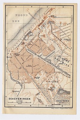
$5.00 Shipping Location: Canada 1910 ANTIQUE CITY MAP OF SCHEVENINGEN/ THE HAGUE DEN HAAG/ HOLLAND NETHERLANDS This original antique map gives you an opportunity to examine in exquisite ... moredetail a piece of history. Once matted and framed. This map would make a perfect gift for a family member or friend they'll cherish forever. Origin of the map: Belgium and Holland" 15th edition, published in Leipzig, Germany by Karl Baedeker, London, T. Fisher Unwin and New York, Charles Scribner's Sons. Date of issue: 1910 Size: The sheet measures: 6" x 4" 15 x 10 cm) S/H: The map will be shipped by Air Mail. The shipping charge is: USA- 2.00 USD. World- 4.00 USD, Canada- 1.00 USD. The price includes a strong and secure envelope. Attention! We combine shipping costs for multiple items. The HIGHEST VALUE SHIPPING FEE WILL APPLY FIRST and each subsequent item will be shipped FOR FREE. Pay me securely with any major credit card through PayPal! Payment methods: US/Canada Buyers: Paypal. International Buyers: Paypal. Click Here. Double your traffic. Get Vendio Gallery- Now FREE! G.RcmdId ViewItemDescV4,RlogId p4%60bo7%60jtb9%3Fuk%601d72f%2Bjw%60hquvg%3Eg-13d6dd6aa2c-0xf9-
Buy It Now
$6.90 Shipping Location: HORNCASTLE, United Kingdom
Buy It Now
$7.95 Shipping Location: San Francisco, United States There is a 2" partially closed tear at the bottom edge and there is loss to the 'engraved by' legend. The map has been folded; otherwise the map is in ... moregood condition. To get the combined rate you should wait until you receive your invoice.
Buy It Now
Free Shipping Location: Netherlands Description: This map originates from the 1588 edition of 'Discrittione di tutti i Paesi Bassi', by L. Guicciardini, published by J. Janssonius. We carry ... moremost maps from this book which was published from 1581-1648. Artists and Engravers: The author of the book this old print originates from is Lodovico Guicciardini (1521-1589): an Italian merchant from aristocratic descent. At our website you will find a more extensive biography.
Buy It Now
$6.95 Shipping Location: Dover, United States Issued 1796, London. The Seven United Provinces from the Best Authorities. Late 18th century engraved map with attractive hand color.
Buy It Now
$6.90 Shipping Location: HORNCASTLE, United Kingdom
Buy It Now
$6.05 Shipping Location: Salem, United States Vintage Nederland Map by Chevron European stmap.
Buy It Now
Free Shipping Location: Troutdale, United States Noordholland Netherlands 1950's Map. Measures 11-5/8" x 15-1/2" unfolded. Excellent condition. Free shipping. (PT2)
Buy It Now
$2.95 Shipping Location: Upton, United States
Buy It Now
$3.75 Shipping Location: United States The fine handcoloring is period to the map, this is before color printing. Printed on thick paper, with no printing on reverse. The size of the map is ... more9.75" by 13". FREE scheduling, supersized images.
Buy It Now
$6.90 Shipping Location: Audubon, United States It is an old, original map that was rescued from an unusable atlas. You will receive the exact antique map in the photos. Condition is very good, age ... moreconsidered. This map would look great displayed in any room.
Buy It Now
$4.99 Shipping Location: Fairview, United States It is drawn and engraved by J. Archer, as stated in the bottom margin and was published in London by H.G. Collins, 22 Pternoster Row. A facsimile copy ... moreof the title page is included for authenticity.
Buy It Now
Free Shipping Location: Sayville, United States Plates 69 and 70 from the 1899 edition of the Andrees Stora Handatlas,a Swedish edition of the well known German Andrees Handatlas. See photo's.
Buy It Now
$4.55 Shipping Location: Oakland, United States This antique map by Rand McNally & Co. from 1899 showcases the countries of Germany and the Netherlands. The intricate details and borders are sure to ... morecapture the attention of any map enthusiast. The publisher's name adds to the value and authenticity of this piece. The map measures 7 inches by 6 inches and is perfect for display or collection.
Buy It Now
$6.90 Shipping Location: Jasper, United States Known for being one of the oldest and most respected publishing houses in Germany, the Bibliographisches Institut specialized in authoritative reference ... moreworks. The map's condition is as shown in the pictures.
Buy It Now
$4.55 Shipping Location: Oakland, United States 12x10 inches This antique map of the German Empire and the Netherlands from the year 1885 is a stunning piece of history. The intricate details and beautiful ... morecolors make it a perfect addition to any antique map collection. The size of the map is 12x10 inches, making it a great display piece for any room.The map originates from the Netherlands and provides a unique view of the region during the late 19th century. The item is categorized as an antique and falls under the categories of Antiques, Maps, Atlases & Globes, and Europe Maps. Add this beautiful antique map to your collection today.
Buy It Now
$4.99 Shipping Location: Fairview, United States , published in London by Grattan & Gilbert, 1838, a copy of the title page is also included for authenticity. Condition: It is in Very Good condition ... morefor its age, basically as seen in the pics, blank on the reverse, with original hand coloring as issued, printed on a heavy paper.
Buy It Now
$4.95 Shipping Location: Portland, United States
Buy It Now
$6.75 Shipping Location: Gainesville, United States By - The A.N.V.V. And The Hague. The Hague. Map Of Holland And The Netherlands.
Buy It Now
$6.95 Shipping Location: Dover, United States Issued c. 1700, likely by Blaeu for Guicciardini. Early 18th century engraved city plan with attractive hand color.
Buy It Now
$4.99 Shipping Location: Fairview, United States A copy of the title page is included for authenticity. It was printed by Chromolithography and has nice strong color. The labeling language is in German. ... moreOverall a beautiful map in great condition.
Buy It Now
$4.99 Shipping Location: Fairview, United States Stieler's Hand Atlas, published in Gotha by Justus Perthes. It is printed on a nice heavy page with bright color. Condition: The map is in Very Good to ... moreExcellent condition with a centerfold as issued, printed on a heavy paper.
$6.00 Shipping Location: Carefree, United States ALSO SHOWN IS PART OF ASIA AND NORTH AFRICA. MAP HAS SCALES BELOW TITLE.
Buy It Now
$6.95 Shipping Location: Dover, United States Issued c. 1840, Edinburgh, by D. Lizars. Fine mid-19th century antique engraved map with original hand color. United Kingdom of the Netherlands Dutch ... moreProvinces.
Buy It Now
$6.95 Shipping Location: Dover, United States (Belgium, Zeeland, Antwerp, Bruges). Uncommon/ rare early 19th century antique engraved folio sheet map with original outline hand color. Originally issued ... moreas part of a huge multi-sheet map, likely 4 or 6 sheets in total, this being a single sheet as seen.
|
|
|
|
Original miniature antique map of the Netherlands by P Bertius, 1600-16
An original copper-graved map of the Netherlands(or Holland) by Pieter Bertius(XVII Provinces and Lower Germania) Published between1600 and 1616. The map is beautifully hand-coloured and probably engraved by Pieter Van den Keere. It was published in the Tablularum geographicarum contractarum libri quatuor. Mounted(210x180mm) Image area 125x90mm. English text verso. Excellent condition.
|
|
|
"Netherlands and Belgium" - Original Engraving - Chapman & Hall - SDUK - Map
Title: The Netherlands and Belgium Year: 1843 Medium: Engraving Published by Chapman& Hall under the superintendence of the SDUK. Map size: 15 1/2 x 12 3/16" 395 x 310 mm) plus margins. The Society for the Diffusion of Useful Knowledge. Better known as SDUK, was an English enterprise devoted to spreading the most up to date cartographic information and enhancing geographical understanding and knowledge of the world. Over a period of years, the maps that the SDUK produced were issued by various publishers. The following is a breakdown. Baldwin& Craddock, 1829-36. Chapman& Hall, c.1844. C. Knight, 1844-52. G. Cox, 1852-3. Stanford, 1857-70. Good condition. Original handcolor. We combine shipping on multiple purchases. Powered by The free listing tool. List your items fast and easy and manage your active items.
|
|
|
Original Antique Map - THE SEVEN UNITED PROVINCES (Netherlands) - 1807, Longman
THE SEVEN UNITED PROVINCES Drawn under the direction of Mr Arrowsmith and Published as the Act directs. Sept. 1st, 1807 by Longman. Hurst, Rees, and Orme, Paternoster Row. Engraved by Cooper. Scale- Approx. 17 miles to an inch Sheet size: 16½" x 10½" This is a genuine antique map. Not a reproduction. As such, some age toning or signs of handling are to be expected. Any significant flaws or defects beyond this are noted below. Disbound. Folded down centre. In good condition. Tanned around edges. Slightly discoloured along fold with small tear at top, but generally clean and neat. Click on pictures to enlarge in a new window I am happy to answer questions or provide whatever information I can. Returns I have tried to provide a description that is fair and accurate. Full refund. Plus cost of return postage, if this lot has ... morebeen misrepresented. If. For any other reason, you are not satisfied with your purchase, I will give a full refund. But postage may be at buyer's expense. Payment PayPal Cheques drawn on any UK account Direct Bank Transfer Banker's Drafts or Postal Orders in GB£ only Buyers outside the UK: PayPal only Please make payment within 7 days. Thankyou Postage Postage by 2nd class mail to the UK. Or standard airmail. Alternative delivery methods at buyer's request. I will combine postage for multiple lots wherever possible.
|
|
|
Bergen-Op-Zoom Holland Netherlands 1780 antique city map plan Lillo detailed
Bergen-Op-Zoom Holland Netherlands 1780 antique city map plan Lillo detailed A New and Exact Plan of the Town and Fortifications of Bergen-Op-Zoom. With the adjacent Forts(Holland/ Netherlands) Issued London. C. 1780 by James MacGowan. Nice. Well-preserved late 18th century engraved map/ plan of this Dutch city and its fortifications. Nicely detailed. In near VG. Mostly clean condition. Map gently toned with some scattered light spotting- hardly offensive- but otherwise clean and quite well-preserved overall. Sheet measures c. 10 1/2" W x 8" H. Engraved area measures c. 8 1/2" W x 6 1/2" H. 5808] Any defects along the sheet edges and in the margins may be seen in the photos. note: All old sheets of printed paper possibly have short edge splits. Each sheet has existed for a very long time and has probably been handled repeatedly ... morein the course of it's existence. It has a history unique to it as an object. Most of the time any edge splits are short. Minor, insignificant and have been closed- either long ago or more recently with small pieces of archival tape. Most often these splits are trivial and easy to overlook visually. Basically, they would not significantly affect the piece adversely. The item is offered as seen. Please look carefully and make your decision knowing this antique image is nice. But it is not in perfect"like new" condition. However, with whatever flaws it possesses, it remains entirely worthy of ownership and inclusion in any related collection. We feel it will prove very pleasing to its new owner. We stand behind everything we sell. Everything we offer is guaranteed to be an authentic original antique item as described. We do not sell modern reproductions. Please visit our. We happily accept PayPal! WE OFFER FLAT RATE SHIPPING WORLD WIDE! Please request an invoice before paying for multiple items so that we can ensure that you are not overcharged for shipping! To receive our flat r
|
|
|
Netherlands Colony New Guinea Oceania 1853 antique Dutch detailed rare map
Netherlands Colony New Guinea Oceania 1853 antique Dutch detailed rare map Kaart det Nederlandsche Bezittingen of het Eiland Nieuw-Guinea door P. Baron Melvill van Carnbee(Indonesia) Issued 1853. Batavia by Haren Noman& Kolff Lithographed by Bogaerts. Breda Fine and uncommon original antique Dutch lithographed map. Printed in the mid 19th century on quality heavy paper which retains its inherent structural flexibility and soundness. With original hand color and the original embossed imprint seal of the Batavia publisher at the bottom of the sheet. In near VG or better condition. Some light and uniform age toning, as well as some minor scattered spotting, neither detract from the overall attractiveness of the image. note: we grade very conservatively and always seek to disclose any noteworthy flaws] The printed area remains visually pleasing. ... moreA nice impression of a very detailed and quite scarce antique map. Depicts this Dutch controlled Indonesian area with a level of detail found virtually no where else at this date. Any minor defects along the sheet edges and in the margins may be seen in the photos. Sheet measures c. 18 7/8" W x 15" H. Engraved area measures c. 15" W x 12" H. 33671] note: All old sheets of printed paper possibly have short edge splits. Each sheet has existed for a very long time and has probably been handled repeatedly in the course of it's existence. It has a history unique to it as an object. Most of the time any edge splits are short. Minor, insignificant and have been closed- either long ago or more recently with small pieces of archival tape. Most often these splits are trivial and easy to overlook visually. Basically, they would not significantly affect the piece adversely. The item is offered as seen. Please look carefully and make your decision knowing this antique image is nice. But it is not in perfect"like new" condition. However, with whatever flaws it possesses, it remains entirely worthy of ownership and inclusion in any related collection. W
|
|
|
1727 Amsterdam Netherlands MAP Repo, City View, Directory, QUALITY, Ships, Pics
1727 Amsterdam MAP* Detailed survey with directory HIGH QUALITY GICLEE REPRODUCTION Great addition to your home decor. The size of this map is. 15" x 12.75" THIS IS AN EXACT REPRODUCTION DIRECTLY FROM THE ORIGINAL SOURCE We use archival quality papers and ink Looks amazing framed! All prints are delivered in a heavy duty poster tube for safe delivery. Customer satisfaction guaranteed! If for some reason you want to return the item. Or your print is damaged, you can return for a full refund no worries. AMSTER WE SHIP ITMES OUT FAST If it's ordered by 11AM Pacific. We ship it same day:
|
|
|
Germany Netherlands Austria West Poland 1871 Stieler antique map w/ hand color
Germany Netherlands Austria West Poland 1871 Stieler antique map w/ hand color Deutschland und Benachbarte Lander zur Ubersicht der Eisenbahnen und Dampfschiffahrten(Germany and Neighboring Country with Railways and Steamboat Lines) Issued 187. Gotha Germany by Perthes for Stieler Fine antique engraved map. With original outline hand color. Made approximately 140 years ago. Printed in the mid-19th century, on quality paper which retains its inherent structural flexibility and soundness. A beautifully engraved and very detailed map of this region. With a profusion of details and small towns not often seen. In Good or better condition. Some moderate scattered foxing as typical, light dampstain at top corner, but these do not detract from the interest or appeal of the map[note: we grade very conservatively and always seek to disclose any noteworthy ... moreflaws] The printed area remains visually pleasing. Overall a nice impression of an interesting map which would warrant close inspection. Sheet measures c. 18 3/8" W x 15 1/8" H. Engraved area measures c. 15 1/2" W x 13" H. 33104] note: All old sheets of printed paper possibly have short edge splits. Each sheet has existed for a very long time and has probably been handled repeatedly in the course of it's existence. It has a history unique to it as an object. Most of the time any edge splits are short. Minor, insignificant and have been closed- either long ago or more recently with small pieces of archival tape. Most often these splits are trivial and easy to overlook visually. Basically, they would not significantly affect the piece adversely. The item is offered as seen. Please look carefully and make your decision knowing this antique image is nice. But it is not in perfect"like new" condition. However, with whatever flaws it possesses, it remains entirely worthy of ownership and inclusion in any related collection. We feel it will prove very pleasing to its new owner. We stand behind everything we sell. Everything we offer is guarantee
|
|
|
1854 ORIGINAL Antique Map NETHERLANDS 8x10 Mat
Auction Wizard 2000 Listing Template- AW2KLOT#4578 tincuptom Auctions 1854 ORIGINAL Antique Map NETHERLANDS 8x10 Mat 157 Years Old.Handcolored ORIGINAL 1854. not a reproduction Matted and Frame Ready Fits any 8 x 10 Frame Map is in GREAT Condition. water stain: bottom left corner. Engraved by G. Boynton Bottom of map reads: Entered according to act of Congress on the 9th day of March by S.Goodrich of Mass. Full page map with no printing on backside Mat measures 8 x 10 inches with a 4.50 x 6.25 inch cut out The USA Shipping is First Class mail. View my other listings for more antique maps. Shipping and handling in the USA is $0.00. Payments are due in 7 day. You may pay by Paypal only. Please E-mail for International Shipping rates.
|
|
|
Joan Blaeu 1649 Antique Hand Coloured Map City of Den Haag Netherlands
Joan Blaeu 1649 Antique Hand Coloured Map City of Den Haag Netherlands. This auction is for a Haga Comitis Vulgo'S Graven-Hage Joan Blaeu 1649 Antique Hand Coloured Map City of Den Haag Netherlands. It's in amazing cosmetic condition. This antique hand coloured map is in excellent shape without any discoloration. The hand coloured still reach and is in amazing shape. There is no sign of damaged or rip on the map. This is a c ity map with rebellions of buildings and houses. Top left the title with command and uitgeversimpressum contained in lobe cartouche with putti on both sides. The coat of arms of Holland is shown by the putto left. The weapon is shown by the Hague Convention putto right. Lower left legend. Hand colored copper engraving. Published in 1649 in Amsterdam by Joan Blaeu in Toonneel der vereenighde Nederlanden, cities ... morewith her descriptions. Back with Dutch text. This map is framed. This specific antique hand coloured map by Joan Blaeu sells in Europe between 1500 to 2000 Euro. Dimensions: Map. Height 38 cm. width 49.5 cm Shipping to Europe is $150.00. Payment method: Paypal only. Email me if you have any questions. Thank you. Powered by
|
|
|
HOLLAND NETHERLANDS Antique Victorian Old Map 1896 Times Atlas 19th century 1800
Antique map of Holland taken from The Times Atlas 1896. In very good condition. Approx 400mm by 250mm. Printed on 145gsm paper.
|
|
|
NW Germany, Netherlands & Belgium Map: Authentic 1876 (Dated) Hand Color; Detail
1876 Large. Dated, Hand-Colored Map Northwest Germany; Netherlands& Belgium This is a 130+ Year-Old Map- NOT a Reproduction Most legends and place names are in the GERMAN language. Includes inset map of Hamburg and vicinity. Bordered map area measures about 16" x 13" and is printed on a single sheet with a fold in the center. There is sufficient margin to allow for easy matting or framing. I have a large scanner. But this map is a little too big for it. First scan below shows almost the full map but not the unprinted margins or the copyright date below the bottom border. see copyright scan below) The second scan below shows a close-up to demonstrate detail and quality; Condition: Very Good-As Shown. This is a beautifully printed map. Technique was copperplate engraving with color delicately hand-applied prior to binding. The ... moremap came from the 1877-78 edition of Stieler's Hand Atlas; published by Justus Perthes in Gotha. Germany. Printed below the bottom border) Bid with confidence- Returnable for any reason within 10 days for prompt refund. Powered by The free listing tool. List your items fast and easy and manage your active items.
|
|
|
1945 Vintage MAP of NETHERLANDS Belgium Luxembourg 1940s Vintage Map
Be sure to add me to your! This is an original. Not reproduction, vintage map of the Netherlands, Belgium and Luxembourg which was carefully removed from an atlas. There is plenty of surrounding border for matting purposes. This map measures approximately 12.5" by 9.5" and is in very good condition. Your item will be packaged in a plastic sleeve. With a thin piece of backing, then in a manila envelope with a very stiff and thick piece of cardboard or in a cardboard mailing tube. We happily combine purchases to save on shipping fees. Please email with questions. We will answer your email promptly! Please visit our ebay store. Plaindealing Vintage Paper. We have stocked it with thousands of vintage advertisements, prints, and historical articles. Check out my! Powered by The free listing tool. List your items fast and easy and manage ... moreyour active items.
|
|
|
Vintage 1967 Netherlands Expo Brochure map design expo67 ephemera
You are bidding on a trifold 1967 Netherlands Expo Brochure map. Feel free to ask any questions you may have! Paypal only. Please. Buyer pays: $3.99 S&H in the US. Good luck! Posted with
|
|
|
Large Antique Map: Netherlands, Belgium, Denmark 1898 Bartolomew Citizen`s Atlas
An original chromolithograph atlas map by Bartholomew Holland& Belgium; Denmark Provenance The Citizen's Atlas of the World. Edited by LL.D. F.R.G.S. Published London: George Newnes. Ltd. Southampton Street, Strand, W.C. 1898. First Edition. Size in millimeters(and inches) Sheet: 448 x 358(17⅝ x 14) Map: 414 x 310(16⅜ x 12¼) Format These maps were all'tipped in' to the atlas. They are all printed on one side only on heavy paper. There is a single fold in the centre of each map. Condition Very Good. The colors are vibrant and fresh. The maps themselves are all. Without exception, clean and free of foxing or tears. On a few maps, there are marks or stains in the margins. These will be visible in the scanned images, which haven't been altered or enhanced in any way. The images are of the actual map you will receive.
|
|
|
Antique Map Zeeland Comitatus Netherlands Blaeu c.1635
This is an authentic c.1635 antique map of ZEELAND COMITATUS/ Netherlands. Published in Amsterdam by Willem Janszoon Blaeu. The actual image measures 19.5" x 15" Condition: As you can see by Photos. There is some serious water staining. This map lived in an old barn) Please e-mail if seriously interested for a full condition report also will be willing to sell without the frame if you have your own frame or want to reduce shipping costs. Thanks! Please note: The white border around map is a temporary paper border and not a professional grade mat.
|
|
|
1906 ORIGINAL ANTIQUE FRENCH MAP OF HOLLAND NETHERLANDS BELGIUM VER
1906 FRENCH MAP OF HOLLAND NETHERLANDS BELGIUM This original antique map gives you an opportunity to examine in exquisite detail a piece of history. If you are interested in the past of this country and its people or have a desire to study where your family may have come from. Then this map gives you a rare look as the area was about 115 years ago. Once matted and framed, this map would make a perfect gift for a family member or friend they'll cherish forever. Origin of the map: E. Schrader's"Atlas de géographie moderne" Published in Paris, France by Librairie Hachette et Cie. Date of issue: 1906 Size: The sheet measures 18" x 14" 46 x 35 cm) TEXT VERSO. S/H: The map will be shipped by Air Mail. The shipping charge is: USA- 7.50 USD. World- 8.50 USD, Canada- 8.50 USD. The price includes the insurance and a ... morestrong, cardboard tube with plastic plugs. Attention! There is no additional shipping charge for multiple purchases! Pay me securely with any major credit card through PayPal! Payment methods: US/Canada Buyers: Paypal. International Buyers: Paypal. Click Here. Double your traffic. Get Vendio Gallery- Now FREE!
|
|
|
1895 NETHERLANDS BELGIUM LUXEMBURG Atlas Map McNally 22X14in ORIGINAL Antique!
An ORIGINAL antique color map of the NETHERLANDS. BELGIUM, and LUXEMBURG from McNally's Atlas, 1895. Map shows countries individually colored. Hundreds of railroads and canals are shown. An index in the margin lists provinces and chief cities. The map shows the pre-WWI borders afterwhich a sliver of the eastern Ardenne was given to Belgium as war reparations. This area would later be a major focus of the Battle of the Bulge in WWII with the massacre at Malmedy. And the flattening of St. Vith, but that was still 50 years after the publication of this map. The map is printed on 2 separate pages and measures 22 by 14 inches total area. Date is printed along the lower border. Perfect for matting and framing. This ORIGINAL antique map is guaranteed 110 years old. I do not sell reproductions. Discounted shipping too. NO international shipping. ... moreNO exceptions. I ship all items within 2 business days. Sometimes the Post Office can be very slow at shipping. If you have not received an item within a reasonable period of time please send me an email and I will track it down. I also offer refunds on EVERY item I sell for ANY reason. Please send me an email. I am very easy to work with. On Oct-19-07 at 13:06:06 PDT. Seller added the following information:
|
|
|
VERY SCARCE MAP OF BELGIUM NETHERLANDS FROM LETTS'S POPULAR ATLAS 1883 VG!
Hello! YOU ARE BIDDING ON SCARCE GENERAL& STATISTICAL MAP OF BELGIUM& NETHERLANDS SHEET NO 35 FROM THE LETTS'S POPULAR ATLAS A COMPLETE SERIES OF MAPS DELINEATING THE WHOLE SURFACE OF THE GLOBE. PUBLISHED BY LETTS& SON LTD. LONDON, 1883 VERY SCARCE FOLIO EDITION. THIS FOLDING MAP IS- 17 1/8 X14 1/8 INCHES(SHEET SIZE) IN VERY GOOD CONDITION. BRIGHT COLORS. SCALE IS 18 MILES TO 1 INCH. COLLECTIBLE PIECE! HAPPY BIDDING! We accept Paypal only. Worldwide shipping for additional cost. Contact me before bidding. We accept returns. We combine shipping cost. Ask question for more info. Thank you for shopping. Check my other listings! Check out my! Attention international customers! Since 01/27/2013 the USPS rised all their prices up to 20-25% All international purchases since this date will require additional costs. Please ask us before ... morebuying and we will revise your items with correct shipping cost.
|
|
|
1938 MAP OF HOLLAND NETHERLANDS BELGIUM
1938 MAP OF HOLLAND NETHERLANDS BELGIUM This original antique map gives you an opportunity to examine in exquisite detail a piece of history. If you are interested in the past of this country and its people or have a desire to study where your family may have come from. Then this map gives you a rare look as the area was about 70 years ago. Once matted and framed, this map would make a perfect gift for a family member or friend they'll cherish forever. Origin of the map: Der Neue Brockhaus" Atlas) Published by F. A. Brockhaus, Leipzig, Germany Date of issue: 1938 Size: The sheet measures 12 1/2" x 9 1/2" 32 x 24 cm) S/H: The map will be shipped by Air Mail as a Letter. The shipping charge is: USA- 2.50 USD/ Canada- 1.70 USD/ World- 4.30 USD. The price includes a strong. Secure envelope. Attention! There is no additional ... moreshipping charge for multiple purchases! Pay me securely with any major credit card through PayPal! Payment methods: US/Canada Buyers: Paypal. International Buyers: Paypal. Click Here. Double your traffic. Get Vendio Gallery- Now FREE! 45c447.RcmdId ViewItemDescV4,RlogId p4%60bo7%60jtb9%3Fuk.rp73%28%3E45c447-13d44123af7-0xfa-
|
|
|
1570 ORTELIUS Map Geldria Gelderland Kleve region IN Netherlands FIRST ATAS L45
This Auction is for an Unframed AUTHORIZED REPRINT of an Antique Map as detailed below. This map is reproduced on specially coated. Matte finish, paper for sharper print quality and colors that are vivid. These maps are created from VERY high resolution uncompressed TIFF files(averaging 200+ megabytes) and are much sharper that the image shown here. Description Map by Abraham Ortelius. 1527-1598, Approximate Image Size 16.5 X 21.5 inches, Original Atlas Title From the 1570 Theatrum Orbis Terrarum Atlas. Considered to be the first modern atlas. WE HAVE MANY HISTORIC REPRINT MAPS AND OTHER ITEMS ON MANY DIFFERENT SUBJECTS Please check out store for additonal products ON MULTIBLE ITEM ORDERS-SHIPPING IS FREE TO ADDRESSES IN THE UNITED STATES BY MAIL(GENERALLY 2 TO 5 DAY DELIVERY) FOR ANY NUMBER OF MAPS SHIPPED IN THE US. SHIPPING IS $15 FOR ... moreTHE FIRST MAP AND $1 FOR EACH ADDITIONAL MAP TO ANYWHERE ELSE IN THE WORLD. WE SHIP ALL MAPS ROLLED IN A MAILING TUBE TO PROTECT THE MAP. IF YOU ARE UNHAPPY WITH YOUR PURCHASE SIMPLY RETURN IT AND WE WILL REFUND YOUR MONEY. Ad copyright 2013 All Rights Reserved Powered by The free listing tool. List your items fast and easy and manage your active items.
|
|
|
Seven Provinces des Pais Bas Netherlands 1679 DuVal w/ old hand color map
Seven Provinces des Pais Bas Netherlands 1679 DuVal w/ old hand color map Les XVII. Provinces des Pais-Bas(Holland/ Netherlands) Issued Paris. 1679 by DuVal. Fine and scarce antique engraved folio sheet map printed in the 17th century. With original hand color. In Fair to Good condition. Light minor age wear, light inoffensive dampstaining across top& bottom, some offsetting and spotting at bottom left, some short minor wrinkling, overall remaining clean and attractive. Left blank margin trimmed close to neatline. A scarce original antique map. Sheet measures c. 23" H x 17" W. Engraved area measures c. 21 1/2" H x 16 1/2" W. Folio. Original fold line as issued. ven der Heijden. Old Maps of the Netherlands. 156-second state. Tooleys Dictionary of Mapmakers. Vol. 1, p. 406. Z11566. Please look carefully and make your ... moredecision knowing this antique image is nice. But it is not in perfect"like new" condition. However, with whatever flaws it possesses, it remains entirely worthy of ownership and inclusion in any related collection. We feel it will prove very pleasing to its new owner. Everything we offer is guaranteed to be an authentic original antique item as described. We do not handle or deal in modern reproductions and stand behind everything we sell. Please visit our. SHIPPING& TERMS: We are happy to combine shipping on multiple items! Simply request a combined invoice before making payment. Also. If the calculated shipping on a single item seems high, feel free to request an invoice before making payment and we'll calculate the correct shipping cost for you. Please be aware that we do not make a profit on shipping and try to keep the cost as low as possible for our customers while still remaining within PayPal and eBay requirements. When you take into account the cost of supplies. Labor and the fees that eBay now charges us on the shipping paid by our customers, we generally take a loss on shipping. BUYER'S OUTSIDE THE USA PLEASE READ BEFORE
|
|
|
Holland Netherlands 1679 rare du Val folio engraved old color map
Holland Netherlands 1679 rare du Val folio engraved old color map Le Cours Du Rhin en sa basse partie. Ou sont Les XVII Provinces. Le Cercle De Westphalie. Les Electorats de Cologne et de Treves. La Hesse, Les Sstats Des Ducs de Brunswick. c(Holland/ Netherlands) Issued Paris. 1679 by DuVal. Fine and scarce antique engraved folio sheet map printed in the 17th century. With original hand color. In Fair to Good condition. Light minor age wear, light inoffensive dampstaining across bottom, some short minor wrinkling, overall remaining clean and attractive. A scarce original antique map. Sheet measures c. 23" W x 17" H. Engraved area measures c. 21 1/2" W x 15 1/2" H. Folio. Original fold line as issued. ven der Heijden. Old Maps of the Netherlands. 173. Tooleys Dictionary of Mapmakers. Vol. 1, p. 406. Z11565. Please look ... morecarefully and make your decision knowing this antique image is nice. But it is not in perfect"like new" condition. However, with whatever flaws it possesses, it remains entirely worthy of ownership and inclusion in any related collection. We feel it will prove very pleasing to its new owner. Everything we offer is guaranteed to be an authentic original antique item as described. We do not handle or deal in modern reproductions and stand behind everything we sell. Please visit our. SHIPPING& TERMS: We are happy to combine shipping on multiple items! Simply request a combined invoice before making payment. Also. If the calculated shipping on a single item seems high, feel free to request an invoice before making payment and we'll calculate the correct shipping cost for you. Please be aware that we do not make a profit on shipping and try to keep the cost as low as possible for our customers while still remaining within PayPal and eBay requirements. When you take into account the cost of supplies. Labor and the fees that eBay now charges us on the shipping paid by our customers, we generally take a loss on shipping. BUYER'S OUTSIDE
|
|
|
Map postcard Bonaire Netherlands Antilles Antillen 1966
This is a colour postcard of Bonaire. Netherlands Antilles. It shows a beautiful map. This postcard was published by Dexter de Wit in 1966. So it is more than 45 years OLD. This postcard was sent to the Netherlands. The publisher’s code is DT-11762-C However a little sellotape stain on top and a little spot on the back(due to stamp removal) they do not affect the picture(see scan) and it is still a great collectable. Condition: good. This postcard should be in every map postcard collection. Buyer pays $ 3.00 for handling and worldwide shipping. Buyer of multiple items can save on shipping. Buyer of multiple items must wait for the invoice. Buyer must make his payment within 14 days. For more map postcards please take a look in my eBay store to make your collection complete. On Mar-06-13 at 20:15:36 PST. Seller added the following information:
|
|
|
Netherlands Holland Vintage Brochure View Lithographic Map VVV Pub. In Dutch 50s
Rare lithographic color brochure printed in Dutch with map of Netherlands. Holland and Amsterdam. Framable. In near mint condition as shown with views opens to map. Published in Holland, circa 1950s dated from view of autombiles and lithographic printing. Prize collectible. EBS1119
|
|
|
1921 Vintage Map NETHERLANDS BELGIUM Holland / EUROPE West part Dated
1921 Vintage Map NETHERLANDS BELGIUM Holland/ EUROPE West part Dated MAP FROM A COLLIERS ATLAS& GAZETTEER OF CITIES& TOWNS OF THE WORLD Offered here is a old great detailed map of the areas(back to back) The map shows roads railroads cities towns and a lot more The map measures approx. 10 x 11 inches(larger than my Scanner) The overall page size is 11 x 14 inches. The map is in Great shape. Clean, no stains, no markings and would frame nicely. This is a great map ideal for collecting, framing& decorating or for tracing the travels of your ancestors. The map is fully guaranteed to be in original and unaltered condition. Check out my STORE for a great selection of 1.00& 2.00 Maps. S&H 5.00 to the United States
|
|
|
Antique map Seventeen Provinces of the Netherlands, by Le Rouge 1748
. Auctor: George Louis Le Rouge(1740-1779) Isles de la Sonde. Issued Paris. was sold by Le Rouge. Prault, Robinot, Desnos and Briassonin Paris) Published by Desnos George Louis Le Rouge Active from 1740- till 1785 as a publisher for the King ofFrance. He specialized in atlases of fortifications and plans hisworks include: Theatre de la Guerre en Allemagne 1741. Nouvel Atlas Portatif. 1748 and 1756. Description du Chateau de Chambord 1750, Recueil des Plans de L'Amerique 1755. Recueil des Cotes Maritimes de France 1757. Atlas Prussien 1758. Recueil des Ville. Ports, d'Angleterre 1759. Topographie des Chemins de l'Angleterre 1760. Recueil des Fortifications. Forts et Ports de mere de France1760. Curiosites de Londres 1765. Curiosities de Paris 1768. Atlas Ameriquain Septentrinal 1778. Pilote Ameriquain Septentrinal 1778-9. ORIGINAL ... moreANTIQUE COPPER PLATE ENGRAVING With fine hand coloring. Engraving is Absolutely Guaranteed authentic original map. A Certificate of Authenticity will be on request forwarded for eachindividual map or print. Image app. 20.5 x 27 cm. 8 x 10.75 inches. Condition: Very good. Fold as published. All maps and prints are genuine. Authentic, published at the date stated in this listing! For better quality pictures please go to our web site: WWW.MAPANDMAPS.COM I offer a no questions returns policy. All maps and prints are genuine. Authentic, published at the date stated above. Worldwide shipping by signed registered mail or Global Express courier. Shipping fee is per combined shipment. Including handling and insurance. Free shipping worldwide if three items or more purchased. . .
|
|
|
Antique map Provinces of Holland and Utrecht Netherlands by Le Rouge 1748
. Isles de la Sonde. Issued Paris. was sold by Le Rouge. Prault, Robinot, Desnos and Briassonin Paris) Published by Desnos George Louis Le Rouge Active from 1740- till 1785 as a publisher for the King ofFrance. He specialized in atlases of fortifications and plans hisworks include: Theatre de la Guerre en Allemagne 1741. Nouvel Atlas Portatif. 1748 and 1756. Description du Chateau de Chambord 1750, Recueil des Plans de L'Amerique 1755. Recueil des Cotes Maritimes de France 1757. Atlas Prussien 1758. Recueil des Ville. Ports, d'Angleterre 1759. Topographie des Chemins de l'Angleterre 1760. Recueil des Fortifications. Forts et Ports de mere de France1760. Curiosites de Londres 1765. Curiosities de Paris 1768. Atlas Ameriquain Septentrinal 1778. Pilote Ameriquain Septentrinal 1778-9. ORIGINAL ANTIQUE COPPER PLATE ENGRAVING With ... morefine hand coloring. Engraving is Absolutely Guaranteed authentic original map. A Certificate of Authenticity will be on request forwarded for eachindividual map or print. Image app. 20.5 x 27 cm. 8 x 10.75 inches. Condition: Very good. Fold as published. All maps and prints are genuine. Authentic, published at the date stated in this listing! For better quality pictures please go to our web site: WWW.MAPANDMAPS.COM I offer a no questions returns policy. All maps and prints are genuine. Authentic, published at the date stated above. Worldwide shipping by signed registered mail or Global Express courier. Shipping fee is per combined shipment. Including handling and insurance. Free shipping worldwide if three items or more purchased. . .
|
|
|
Map of Holland or the Netherlands and Belgium antique atlas map by Migeon 1884
. Map of Holland or the Netherlands andBelgium antique atlas map by Migeon 1884 Title: Hollande et Belgique Description: Old map shows. Zeeland,Utrecht, Gelderland, Over Ijssel, Friesland andGroningen. Signed: Gravée par Sengteller Dressée par Desbuissons Géographie Revue A.T. Cartier From: ATLAS– MIGEON Historique Scientifique. Industriel et Commercial. Paris– Imp. Carré et C. ORIGINAL ANTIQUE HAND COLORED MAP. Map is absolutely Guaranteed authentic and a original map. A Certificate of Authenticity will be on request forwarded for eachindividual map or print. Sheet app. 45 x 35 cm. 17.75 x 13.75 inches. Image app. 38 x 28 cm. 15 x 11 inches. Condition: Very good detailed atlas map with hand coloring.shipment in tube included original description) All maps and prints are genuine. Authentic, published at the date stated ... morein this listing! For better quality pictures please go to our web site: WWW.MAPANDMAPS.COM I offer a no questions returns policy. All maps and prints are genuine. Authentic, published at the date stated above. Worldwide shipping by signed registered mail or Global Express courier. Shipping fee is per combined shipment. Including handling and insurance. Free shipping worldwide if three items or more purchased. . .
|
|
|
Russian Chromolithograph Plate MAP 1909 Benelux - Belgium Netherlands Luxembourg
★ ★ ★ ★ ★ 5-star service for you ★ ★ ★ ★ ★ ★ Worldwide shipping within 1 business day of payment ★ Professional Packaging ★ Tracking registered air mail ★ Possibility Express Mail Service ★ Combined Shipping Discount or Free shipping After you have won the item. You have 4 days to pay( if no bid on other item) or PLEASE LET ME KNOW POSSIBLE TERM OF PAYMENT. Большой всемирный настольный Атлас Маркса Хромолитографированная карта. Настоящая карта из издания«Большого Всемирного настольного атласа Маркса. Ред. покойного проф. Э.Ю.Петри. Ю.М.Шокальского» Спб. 1909) Знаменитый Атлас А.Ф.Маркса начал составляться в 1903 г. из карт. Созданных под редакцией выдающегося русского географа Эдуарда Юльевича Петри(1854- 1899) Э.Ю.Петри являлся профессором Бернского университета. А в 1887 г. он был приглашен занять кафедру географии и антропологии ... moreПетербургского университета. Э.Ю.Петри окончил Медико-хирургическую академию, после которой отправился за границу для усовершенствования. Он слушал лекции во многих университетах Германии и Швейцарии и затем в 1880 г. получил в Бернском университете степень доктора медицины. Как лектор он умел увлекать аудиторию, преподносить сухую географическую науку интересно. Это искусство отразилось и в его картах. В атлас вошли данные, полученные в ходе многочисленных экспедиций Э.Ю.Петри по Средней Азии, Тургайской области, Приуралью, Оренбургской и Уфимской губерниям и вообще почти по всем областям России. Атлас А.Ф.Маркса представляет новые способы подачи материала. Его отличают. Наглядность, систематичность и ясность, наряду с колоссальным богатством точной географической информации, выраженной не только непосредственно в картах, но и во вспомогательных графиках и схемах. В атласе отдано предпочтение физической географии, поскольку именно в определенных физико-географических условиях развиваются все социально-политические системы. Карты атласа отличаются яркостью и декоративностью. Атлас был закончен Ю.М.Шокальским– председателем Отделения физической географии Императорского Русско
|
|
|
1854 Perthes Map of Northwestern Germany with Netherlands and Belgium
1854 Perthes Map of Northwestern Germany with Netherlands and Belgium WE SELL ONLY ORIGINAL ANTIQUE MAPS- NOT REPRODUCTIONS Title: Nordwestliches Deutschland(Preuss. Rheinprovinz u. Westphalen, Kgr. Hannover, Oldenburg, Braimschweig, Lippe, Waldeck, die Hessischen Lande, Nassau) Kgr. der Niederlande. Kgr. Belgien. Description: A fascinating example of the 1854 Justus Perthes map of northwestern Germany. Holland, and Belgium. The map covers from the North Sea to the Lower Rhine, including Holland and Belgium, as well as parts of Lower Saxony, Preuss, Rhine Province, Westphalia, Hanover, Oldenburg, Braimschweig, Waldeck, Hesse, and Nassau. In 1848 the March Revolution swept through Europe, in particular Germany. These Revolutions were nationalist pro-German, pan-German, declarations of discontent with the archaic autocratic political structure ... morethat dated to the 39 original German states established under the Holy Roman Empire. The years following the violent suppression of the March Revolution saw a vast middle class exodus from the German states to the United States, leading to'Germantown USA, and popular interest among Americans in the Fatherland. Throughout, the map identifies various cities, towns, rivers and assortment of additional topographical details. Political and regional borders are highlighted in outline color. Unlike other cartographic publishers of the period, the Justus Perthes firm, did not transition to lithographic printing techniques. Instead, all of their maps are copper plate engravings and hence offer a level of character and depth of detail that was impossible to find in lithography or wax-process engraving. All text is in German. Issued as plate no. 21 in the 1854 edition of Stieler’s Hand-Atlas. Size: Printed area measures 13.5 inches high by 16 inches wide. Condition: Very Good. Original centerfold. Blank on verso. Small verso repair along centerfold. Shipping: Due to recent increases in United States Postal Service rates we have been forced to increase our shipping rates. Shipping
|
|
|
1892 Rand McNally Map of Belgium and the Netherlands
1892 Rand McNally Map of Belgium and the Netherlands WE SELL ONLY ORIGINAL ANTIQUE MAPS- NOT REPRODUCTIONS Title: Map of Belgium and The Netherlands. Description: This is a beautiful example of Rand McNally and Company's 1891 map of Belgium and the Netherlands. The map covers both Holland and Belgium from Friesland to Luxembourg and includes the Grand Duchy of Luxemburg. An inset in the upper left quadrant details the Plan of Brussels. In 1830. The Belgian Revolution led to the secession of Belgium from the United Kingdom of Netherlands and it's subsequently consolidation as the independent Kingdom of Belgium. Though Belgium had successfully attained self-rule, the Netherlands refused to recognize the new country until the 1839 Treaty of London. The Grand Duchy of Luxemburg continued to be part of the Netherlands until 1890 when the ... moreGrand Duke of Luxemburg and King of the Netherlands, William III, died with no male heirs. The Dutch throne passed on to his daughter, but Nassau Family Pact, restricted Luxembourg to a male heir so the throne passed to House of Nassau-Weilburg. Color coded according to territories, the map notes several towns, cities, rivers and various other topographical details with relief shown by hachure. This map was issued as plate no. 53 in the 1895 issue of Rand McNally and Company's Indexed Atlas of the World- possibly the finest atlas Rand McNally ever issued. Size: Printed area measures 20 inches high by 13 inches wide. Condition: Very good. Text on verso. Shipping: Due to recent increases in United States Postal Service rates we have been forced to increase our shipping rates. Shipping rates are not negotiable. Items are shipped within three business days of receiving payment. We are happy to consolidate shipping where possible. The following shipping options are available: 1. USPS Domestic Express Mail(35 USD) USA Only. 2. USPS Priority Mail(15 USD) USA Only. 3. USPS International Express(35 to 55 USD) Recommended service for all international parcels. You will be invoiced a
|
|
|
Catholic Netherlands Belgium German France antique map Anonymous 1745
. Catholic Netherlands Belgium German France antique map Anonymous 1745 Title: Generale Map of the Catholick Netherlands The South West part of Germany. Lorrain and the Fronsiers of France towards each. ORIGINAL ANTIQUE MAP Hand colored. WE SELL ONLY ORIGINAL ANTIQUE MAPS Map is Guaranteed authentic. A Certificate of Authenticity will be on request forwarded for each individual map or print. Size: Size app. 25.5 x 20 cm. 10.1 x 7.8 inches. Image app. 23 x 18 cm. 9 x 7.2 inches. Condition: View overall very good. Folds as published. All maps and prints are genuine. Authentic, published at the date stated in this listing! For better quality pictures please go to our web site: WWW.MAPANDMAPS.COM I offer a no questions returns policy. All maps and prints are genuine. Authentic, published at the date stated above. Worldwide shipping by ... moresigned registered mail or Global Express courier. Shipping fee is per combined shipment. Including handling and insurance. Free shipping worldwide if three items or more purchased. . .
|
|
|
Netherlands Belgium Luxembourg antique map Longman 1860
. Netherlands Belgium Luxembourg antique map Longman 1860 Title: HOLLAND AND BELGIUM London Published by Longman Engraving by Sid. Hall Hand colored antique engraving. Size: Image app. 19 x 23.5 cm. 7.5 x 9.25 inches. Condition: View overall very good. Fold as published.. All maps and prints are genuine. Authentic, published at the date stated in this listing! For better quality pictures please go to our web site: WWW.MAPANDMAPS.COM I offer a no questions returns policy. All maps and prints are genuine. Authentic, published at the date stated above. Worldwide shipping by signed registered mail or Global Express courier. Shipping fee is per combined shipment. Including handling and insurance. Free shipping worldwide if three items or more purchased. . .
|
|
|
Netherlands P96 50 Gulden SUNFLOWER WITH BEE & MAP & FLOWERS 4.1.1982 VF/XF RARE
Netherlands P96 50 Gulden SUNFLOWER WITH BEE& MAP& FLOWERS 4.1.1982 VF/XF RARE circulated with a tear on mid edge Please See Scan before Bidding SHIPPING UPDATE Postal Costs have gone up in UK from 30 April 2012 We have now revised our postal costs within reason Combined Shipping I offer combined shipping for UK £1 Standard Shipping or £2.00 Recorded Also available to Europe and Rest of the World For any Query you can email me on stanleyukc@yahoo.com and I will try to reply Grading is done on a honest basis and it is not a quantifiable science to measure All my items are guaranteed If you feel item not as described and gross difference then send it back for a no quibble refund No return postage cost are given Thank you for looking at my items and your support
|
|
|
Netherlands Belgium Luxemburg 1861 Map By Perthes Hand Colored Holland Antwerp
Netherlands Belgium Luxemburg 1861 Map By Perthes Hand Colored Holland Antwerp NETHERLANDS Original 1861 map"Die Niederlande Belgien und Luxemburg" Hand colored, by Perthes. This 152 year old map is dated in lower margin and is in very good condition, overall size 17 1/2' x 14 3/4' Purchase with confidence. We have been in the antique print, map, and document business since 1976 and guarantee our items as advertised. See additional photos below! To See More Photos/Scenes Powered by
|
|
|
1900 MAP OF DENMARK / NETHERLANDS HOLLAND BELGIUM
1900 MAP OF DENMARK/ NETHERLANDS HOLLAND BELGIUM This original antique map gives you an opportunity to examine in exquisite detail a piece of history. Once matted and framed. This map would make a perfect gift for a family member or friend they'll cherish forever. Origin of the map: The Citizen's Atlas of the World" Edited by J. G. Bartholomew, published in London, U.K. by George Newnes. Date of issue: Ca. 1900 Size: The sheet measures 18" x 14" 46 x 35 cm) THE MAP IS REPAIRED ON BACK ALONG THE CENTERFOLD. S/H: The map will be shipped by Air Mail. The shipping charge is: USA- 6.50. World/Canada- 7.50. The price includes the insurance and a strong, cardboard tube with plastic plugs. Attention! There is no additional shipping charge for multiple purchases! Pay me securely with any major credit card through PayPal! Payment ... moremethods: US/Canada Buyers: Paypal. International Buyers: Paypal. Click Here. Double your traffic. Get Vendio Gallery- Now FREE!
|
|
|
Netherlands Amsterdam Harlem Breda 1849 antique engraved old color map
Netherlands Amsterdam Harlem Breda 1849 antique engraved old color map Das Konigreich Holland Issued 1849. Hildburghausen, Germany Fine original antique engraved map. Printed on quality paper which retains its inherent structural flexibility and soundness. Original hand color outline. Charming inset city plans of Amsterdam. Breda, Haarlem& leiden. In near VG or better condition. Some light age wear that does not detract from the overall attractiveness of the image[note: we grade very conservatively and always seek to disclose any noteworthy flaws] The printed area remains visually pleasing. A nice impression of an interesting antique map. Any minor defects along the sheet edges and in the margins may be seen in the photos. Sheet measures c. 11" H x 9 3/8" W. Engraved area measures c. 10" H x 7 1/4" W. Original fold ... moreline as issued. 36847] note: All old sheets of printed paper possibly have short edge splits. Each sheet has existed for a very long time and has probably been handled repeatedly in the course of it's existence. It has a history unique to it as an object. Most of the time any edge splits are short. Minor, insignificant and have been closed- either long ago or more recently with small pieces of archival tape. Most often these splits are trivial and easy to overlook visually. Basically, they would not significantly affect the piece adversely. The item is offered as seen. Please look carefully and make your decision knowing this antique image is nice. But it is not in perfect"like new" condition. However, with whatever flaws it possesses, it remains entirely worthy of ownership and inclusion in any related collection. We feel it will prove very pleasing to its new owner. We stand behind everything we sell. Everything we offer is guaranteed to be an authentic original antique item as described. We do not sell modern reproductions. Please visit our eBay Store. We happily accept PayPal! WE OFFER FLAT
|
|
|
NETHERLANDS, HOLLAND, BELGIUM original antique map 1807
THE SEVEN UNITED PROVINCES by Aaron Arrowsmith Published London 1807 by Longman. Hurst, Rees& Orme. A detailed steel engraved map of The Netherlands. Dated in the plate. Some faint patchy browning to the extremeties. Centre fold as issued. Blank verso on medium grade wove paper. Approx. 15.5" x 10" 390mm x 250mm) map area only with margins beyond. Please scroll right down for a close up image. A GENUINE ANTIQUE MAP GUARANTEED OVER 200 YEARS OLD FROM LINDISFARNE PRINTS We do not deal in reproductions. Facsimiles or copies of any kind. SHIPPING Within UK £1.95 via Royal Mail First class. Europe £2.50 via Royal Mail Airmail. USA and rest of the world- £3.95 via Royal Mail Airmail. Why not browse our ebaystore? THANKS FOR YOUR INTEREST! Be sure to add me to your! Check out my! NMB611. Powered by
|
|
|
NETHERLANDS, SEVEN UNITED PROVINCES, Original Hand Coloured Antique Map c1810
NETHERLANDS. SEVEN UNITED PROVINCES, Original Hand Coloured Antique Map c1810, NETHERLANDS. SEVEN UNITED PROVINCES, Original Hand Coloured Antique Map c1810 THE SEVEN UNITED PROVINCES WITH THEIR DEPENDENCIES published. London c1810 by C.Cooke for a Modern& Authentic System of Universal Geography. by George Alexander Cooke An attractive map of the Republic of the Seven United Netherlands With original hand colouring. Fold lines as issued& blank verso. A fine impression with light overall age toning. Measuring approx. 10" x 8.5" 260mm x 220mm) map area only. With margins beyond. Please see close ups for a further image A GENUINE ANTIQUE MAP GUARANTEED OVER 200 YEARS OLD FROM LINDISFARNE PRINTS M6313 SHIPPING Within UK- £2.95 via Royal Mail First class. From UK to Europe- £3.95 via Royal Mail Airmail. From the UK ... moreto USA and rest of the world- £4.95 via Royal Mail Airmail. TWO ITEMS WILL BE COMBINED. WITH ONE SHIPPING CHARGE. THREE ITEMS OR MORE SHIPPED FREE OF CHARGE. WORLDWIDE! Closeups, Shipping Process, Two items are always combined for shipping and three items or more are shipped free of charge. Worldwide"Please see item description for postage costs" Payment Options, All major Credit and debit cards via PAYPAL. Personal cheque drawn on UK banks only. Postal Orders from UK post offices only. Bank transfer- please email for details. About Us, Lindisfarne Prints is a small family business specialising in genuine antique maps and prints at affordable prices.Established in 1995 and trading online since 2000. We pride ourselves on accurate descriptions, good communications, rapid service and fair prices. We are proud to maintain a 100% positive feedback rating which we hope reflects this.To avoid confusion, no item less than 100 years old is ever offered for sale. We do not deal in reproductions, facsimiles or modern copies of any kind. So please buy with confidence in the safe knowledge that authenticity is unfailingly assured. Ret
|
|
|
1893 ORIGINAL ANTIQUE MAP OF SWITZERLAND / BELGIUM NETHERLANDS DENMARK ON REV.
1893 ORIGINAL ANTIQUE MAP OF SWITZERLAND/ BELGIUM NETHERLANDS DENMARK ON REV. This original antique map gives you an opportunity to examine in exquisite detail a piece of history. Once matted and framed. This map would make a perfect gift for a family member or friend they'll cherish forever. Origin of the map: International Office and Family Atlas of the World" Published by John F. Waite. Chicago, USA. Date of issue: 1893 Size: The sheet measures 14 1/4" x 11" 36 x 28 cm) S/H: The map will be shipped by Air Mail. The shipping charge is: USA- 6.50 USD. World- 7.50 USD, Canada- 7.50 USD. The price includes the insurance and a strong, cardboard tube with plastic plugs. Attention! There is no additional shipping charge for multiple purchases! Pay me securely with any major credit card through PayPal! Payment methods: US/Canada ... moreBuyers: Paypal. International Buyers: Paypal. Click Here. Double your traffic. Get Vendio Gallery- Now FREE! RcmdId ViewItemDescV4,RlogId p4%60bo7%60jtb9%3Fv%7F.rpn30%3E-13d6a291d28-0x103-
|
|
|
1882 ANTIQUE MAP OF HOLLAND NETHERLANDS / BELGIUM
1882 ANTIQUE MAP OF HOLLAND NETHERLANDS/ BELGIUM This original antique map gives you an opportunity to examine in exquisite detail a piece of history. If you are interested in the past of this country and its people or have a desire to study where your family may have come from. Then this map gives you a rare look as the area was about 130 years ago. Once matted and framed, this map would make a perfect gift for a family member or friend they'll cherish forever. Origin of the map: Stielers Handatlas" Published in Gotha, Germany by Justus Perthes. Date of issue: 1882 Size: The sheet measures 18 3/4" x 15" 47.5 x 38 cm) S/H: The map will be shipped by Air Mail. The shipping charge is: USA- 7.50 USD. World- 8.50 USD, Canada- 8.50 USD. The price includes the insurance and a strong, cardboard tube with plastic plugs. Attention! ... moreThere is no additional shipping charge for multiple purchases! Pay me securely with any major credit card through PayPal! Payment methods: US/Canada Buyers: Paypal. International Buyers: Paypal. Click Here. Double your traffic. Get Vendio Gallery- Now FREE!
|
|
|
1908 ANTIQUE MAP OF HOLLAND NETHERLANDS BELGIUM / AMSTERDAM BRUSSELS
1908 ANTIQUE MAP OF HOLLAND NETHERLANDS BELGIUM/ AMSTERDAM BRUSSELS This original antique map gives you an opportunity to examine in exquisite detail a piece of history. If you are interested in the past of this country and its people or have a desire to study where your family may have come from. Then this map gives you a rare look as the area was about 100 years ago.Once matted and framed, this map would make a perfect gift for a family member or friend they'll cherish forever. Origin of the map: Bacon's Popular Atlas of The World" Published in London by G. W. Bacon. Date of issue: 1908 Size: The sheet measures 21" x 13 1/2" 54 x 34 cm) S/H: The map will be shipped by Air Mail. The shipping charge is: USA- 7.50 USD. World- 8.50 USD, Canada- 8.50 USD. The price includes the insurance and a strong, cardboard tube with ... moreplastic plugs. Attention! There is no additional shipping charge for multiple purchases! Pay me securely with any major credit card through PayPal! Payment methods: US/Canada Buyers: Paypal. International Buyers: Paypal. Click Here. Double your traffic. Get Vendio Gallery- Now FREE!
|
|
|
1918 MAP OF SWEDEN NORWAY HOLLAND NETHERLANDS BELGIUM
1918 MAP OF SWEDEN NORWAY HOLLAND NETHERLANDS BELGIUM This original antique map gives you an opportunity to examine in exquisite detail a piece of history. If you are interested in the past of this country and its people or have a desire to study where your family may have come from. Then this map gives you a rare look as the area was about 90 years ago. Once matted and framed, this map would make a perfect gift for a family member or friend they'll cherish forever. Origin of the map: B. Doubleday. Page& Co's, Geographical Manual and New Atlas" Garden City, New York, USA. Date of issue: 1918 Size: The sheet measures 13" x 9 1/4" 33 x 23 cm) S/H: The map will be shipped by Air Mail. The shipping charge is: USA- 6.50 USD. World- 7.50 USD, Canada- 7.50 USD. The price includes the insurance and a strong, cardboard tube ... morewith plastic plugs. Attention! There is no additional shipping charge for multiple purchases! Pay me securely with any major credit card through PayPal! Payment methods: US/Canada Buyers: Paypal. International Buyers: Paypal. Click Here. Double your traffic. Get Vendio Gallery- Now FREE!
|
|
|
1910 ANTIQUE CITY MAP OF MAASTRICHT / HOLLAND NETHERLANDS
1910 ANTIQUE CITY MAP OF MAASTRICHT/ HOLLAND NETHERLANDS This original antique map gives you an opportunity to examine in exquisite detail a piece of history. Once matted and framed. This map would make a perfect gift for a family member or friend they'll cherish forever. Origin of the map: Belgium and Holland" 15th edition, published in Leipzig, Germany by Karl Baedeker, London, T. Fisher Unwin and New York, Charles Scribner's Sons. Date of issue: 1910 Size: The sheet measures: 6" x 4" 15 x 10 cm) S/H: The map will be shipped by Air Mail. The shipping charge is: USA- 2.00 USD. World- 4.00 USD, Canada- 1.00 USD. The price includes a strong and secure envelope. Attention! We combine shipping costs for multiple items. The HIGHEST VALUE SHIPPING FEE WILL APPLY FIRST and each subsequent item will be shipped FOR FREE. Pay ... moreme securely with any major credit card through PayPal! Payment methods: US/Canada Buyers: Paypal. International Buyers: Paypal. Click Here. Double your traffic. Get Vendio Gallery- Now FREE!
|
|
|
1758 MAP OF BATTLE OF MEER MEHR HAMMINKELN MEHRHOOG GERMANY NETHERLANDS
1758 MAP OF BATTLE OF MEER MEHR HAMMINKELN MEHRHOOG GERMANY NETHERLANDS This original antique map gives you an opportunity to examine in exquisite detail a piece of history. Once matted and framed. This map would make a perfect gift for a family member or friend they'll cherish forever. Origin of the map: London Magazine Date of issue: 1758 Size: The sheet measures: 8" x 4 3/4" 20.5 x 12.5 cm) S/H: The map will be shipped by Air Mail. The shipping charge is: USA- 2.50 USD. World- 4.50 USD, Canada- 1.50 USD. The price includes a strong and secure envelope. Attention! We combine shipping costs for multiple items. The HIGHEST VALUE SHIPPING FEE WILL APPLY FIRST and each subsequent item will be shipped FOR FREE. Pay me securely with any major credit card through PayPal! Payment methods: US/Canada Buyers: Paypal. International Buyers: ... morePaypal. Click Here. Double your traffic. Get Vendio Gallery- Now FREE!
|
|
|
1937 Hammond ATLAS MAP NETHERLANDS BELGIUM & LUXEMBURG 76 Yrs Old
1937 Hammond ATLAS NETHERLANDS BELGIUM& LUXEMBURG 76 Yrs Old
|
|
|
1903 ANTIQUE FRENCH MAP OF HOLLAND NETHERLANDS BELGIUM
1903 ANTIQUE FRENCH MAP OF HOLLAND NETHERLANDS BELGIUM This original antique map gives you an opportunity to examine in exquisite detail a piece of history. If you are interested in the past of this country and its people or have a desire to study where your family may have come from. Then this map gives you a rare look as the area was about 110 years ago. Once matted and framed, this map would make a perfect gift for a family member or friend they'll cherish forever. Origin of the map: Atlas Larousse Illustré" Published in Paris, France by Librairie Larousse. Date of issue: 1903 Size: The sheet measures 12" x 9 1/4" 31 x 23 cm) S/H: The map will be shipped by Air Mail. The shipping charge is: USA- 6.50. World/Canada- 7.50. The price includes the insurance and a strong, cardboard tube with plastic plugs. Attention! ... moreThere is no additional shipping charge for multiple purchases! Pay me securely with any major credit card through PayPal! Payment methods: US/Canada Buyers: Paypal. International Buyers: Paypal. Click Here. Double your traffic. Get Vendio Gallery- Now FREE!
|
|
|
1910 ANTIQUE CITY MAP OF LEEUWARDEN / HOLLAND NETHERLANDS
1910 ANTIQUE CITY MAP OF LEEUWARDEN/ HOLLAND NETHERLANDS This original antique map gives you an opportunity to examine in exquisite detail a piece of history. Once matted and framed. This map would make a perfect gift for a family member or friend they'll cherish forever. Origin of the map: Belgium and Holland" 15th edition, published in Leipzig, Germany by Karl Baedeker, London, T. Fisher Unwin and New York, Charles Scribner's Sons. Date of issue: 1910 Size: The sheet measures: 6" x 4" 15 x 10 cm) S/H: The map will be shipped by Air Mail. The shipping charge is: USA- 2.00 USD. World- 4.00 USD, Canada- 1.00 USD. The price includes a strong and secure envelope. Attention! We combine shipping costs for multiple items. The HIGHEST VALUE SHIPPING FEE WILL APPLY FIRST and each subsequent item will be shipped FOR FREE. Pay ... moreme securely with any major credit card through PayPal! Payment methods: US/Canada Buyers: Paypal. International Buyers: Paypal. Click Here. Double your traffic. Get Vendio Gallery- Now FREE!
|
|
|
1910 ANTIQUE CITY MAP OF SCHEVENINGEN / THE HAGUE DEN HAAG / HOLLAND NETHERLANDS
1910 ANTIQUE CITY MAP OF SCHEVENINGEN/ THE HAGUE DEN HAAG/ HOLLAND NETHERLANDS This original antique map gives you an opportunity to examine in exquisite detail a piece of history. Once matted and framed. This map would make a perfect gift for a family member or friend they'll cherish forever. Origin of the map: Belgium and Holland" 15th edition, published in Leipzig, Germany by Karl Baedeker, London, T. Fisher Unwin and New York, Charles Scribner's Sons. Date of issue: 1910 Size: The sheet measures: 6" x 4" 15 x 10 cm) S/H: The map will be shipped by Air Mail. The shipping charge is: USA- 2.00 USD. World- 4.00 USD, Canada- 1.00 USD. The price includes a strong and secure envelope. Attention! We combine shipping costs for multiple items. The HIGHEST VALUE SHIPPING FEE WILL APPLY FIRST and each subsequent item will be ... moreshipped FOR FREE. Pay me securely with any major credit card through PayPal! Payment methods: US/Canada Buyers: Paypal. International Buyers: Paypal. Click Here. Double your traffic. Get Vendio Gallery- Now FREE! G.RcmdId ViewItemDescV4,RlogId p4%60bo7%60jtb9%3Fuk%601d72f%2Bjw%60hquvg%3Eg-13d6dd6aa2c-0xf9-
|
|
|
1910 ANTIQUE CITY MAP OF VICINITY OF ARNHEM / HOLLAND NETHERLANDS
1910 ANTIQUE CITY MAP OF VICINITY OF ARNHEM/ HOLLAND NETHERLANDS This original antique map gives you an opportunity to examine in exquisite detail a piece of history. Once matted and framed. This map would make a perfect gift for a family member or friend they'll cherish forever. Origin of the map: Belgium and Holland" 15th edition, published in Leipzig, Germany by Karl Baedeker, London, T. Fisher Unwin and New York, Charles Scribner's Sons. Date of issue: 1910 Size: The sheet measures: 6" x 4" 15 x 10 cm) S/H: The map will be shipped by Air Mail. The shipping charge is: USA- 2.00 USD. World- 4.00 USD, Canada- 1.00 USD. The price includes a strong and secure envelope. Attention! We combine shipping costs for multiple items. The HIGHEST VALUE SHIPPING FEE WILL APPLY FIRST and each subsequent item will be shipped FOR ... moreFREE. Pay me securely with any major credit card through PayPal! Payment methods: US/Canada Buyers: Paypal. International Buyers: Paypal. Click Here. Double your traffic. Get Vendio Gallery- Now FREE!
|
|
|
ANTIQUE HISTORICAL MAP, AUSTRIAN NETHERLANDS, LUXEMBOURG, BRION DE LA TOUR 1766
. Title: Les Pays Bas. François. Autrichiens et Hollandois. His official title was"Engineer Geographer of the King. Published by: Claude Buy de Mornas was. Bookseller and geographical engineer forglobes and spheres of His Danish Majesty. from"Atlas Méthodique et Elémentaire de Géographie et d'Histoire. Hand colored. Engraving is Guaranteed authentic. A Certificate of Authenticity will be on request forwarded for eachindividual map or print. Size: Sheet app. 50 x 33 cm. 19.75 x 13 inches. Condition: Very good. Light browned centre fold. All maps and prints are genuine. Authentic, published at the date stated in this listing! For better quality pictures please go to our web site: WWW.MAPANDMAPS.COM I offer a no questions returns policy. All maps and prints are genuine. Authentic, published at the date ... morestated above. Worldwide shipping by signed registered mail or Global Express courier. Shipping fee is per combined shipment. Including handling and insurance. Free shipping worldwide if three items or more purchased. . .
|
|
|
1981 Original Funk Map NETHERLANDS BELGIUM LUXEMBOURG / UNITED KINGDOM England
Offered here is a old map of the areas(back to back) The map measures approx. 8 1/2 x 11 inches The map is in mint condition. Clean, no stains, no markings and would frame nicely Check out my STORE for a great selection of maps Bid on more maps and SAVE on S&H.RcmdId ViewItemDescV4,RlogId p4%60bo7%60jtb9%3Fv%7F.rpn33%3E-13d81322dfd-0x107-
|
|
|
"The Kingdom of the Netherlands" - Original Engraving - SDUK - Map
Title: The Kingdom of the Netherlands Year: 1830 Medium: Engraving Published by Baldwin& Cradock under the superintendence of the SDUK. Map size: 13 9/16 x 9 5/8" 344 x 245 mm) plus margins. The Society for the Diffusion of Useful Knowledge. Better known as SDUK, was an English enterprise devoted to spreading the most up to date cartographic information and enhancing geographical understanding and knowledge of the world. Over a period of years, the maps that the SDUK produced were issued by various publishers. The following is a breakdown. Baldwin& Craddock, 1829-36. Chapman& Hall, c.1844. C. Knight, 1844-52. G. Cox, 1852-3. Stanford, 1857-70. Good to fair condition with scattered foxing. Original handcolor. We combine shipping on multiple purchases. Powered by The free listing tool. List your items fast and easy and manage ... moreyour active items.
|
|
|
1745 Fine Moll Map of Flanders, Spanish Netherlands, Luxembourg
1745 Moll Map- Flanders' Herman Moll was probably the greatest self-promoter of all eighteenth century cartographers. A Dutch/German emigre to London in the late 1600's. He managed to find influential friends and backers and he enjoyed success right up to his death in 1732. He published several atlas and his maps were also used by Thomas Salmon. The author of several travel books and geographies of the mid eighteenth century including'Modern History' This attractive map of Flanders comes from a 1745 edition of'Modern History' and is a fine example of Moll's distinctive. Clear engraving style. The map is very detailed naming the provinces. And major cities and towns. Moll's name is shown in the title cartouche, and there is a legend and scale of distance. The map measures 7" by 10" Has outline hand ... morecolouring, and is in very good condition. This map is guaranteed to be over 260 years old. Shipping United States- Regular airmail $5.00US. Registered/insured airmail with tracking(optional) is an additional US$15.00 for a total of US$20.00. Canada- $3.00US for regular mail. $9.00US for registered mail. Canadian customers please add GST or HST as applicable. Sorry, we cannot arrange for pick up of ebay items. Rest of the world- Regular air mail $8.00US. Registered/insured airmail with tracking(optional) is is an additional US$15.00 for a total of US$23.00. Terms and Conditions Please note- We can only take responsibility for delivery if the optional registration/insurance is added. Regular airmail is usually very safe and reliable. But items sent by regular airmail are at the buyers risk- regular airmail provides no tracking number, no proof of shipping or delivery, and no insurance in case of loss or damage. Please note- Mailing from Canada to the United States and all other international destinations can sometimes take over three weeks for delivery. We will combine shipment of multiple purchases- several items can be shipped together for one shipping cost. Payment Options We a
|
|
|
NETHERLANDS & BELGIUM, original antique hand coloured map c1840
NETHERLANDS& BELGIUM. Original antique hand coloured map c1840, NETHERLANDS& BELGIUM. Original antique hand coloured map c1840 THE NETHERLANDS De Nederlanden and BELGIUM la Belgique Engraved by J&C Walker and published by Edward Stanford. London circa 1840 for"The Society For The Diffusion Of Useful Knowledge" An attractive and highly detailed steel engraved map of The Netherlands and Belgium. With original full hand colouring. Fine. Unmarked condition. Not folded. Approx. 16" x 12" 400mm x 310mm) map area only. With margins beyond. Would frame up well. Please scroll right down for further image. A GENUINE ANTIQUE MAP GUARANTEED OVER 150 YEARS OLD FROM LINDISFARNE PRINTS VNFM113 We do not deal in reproductions. Facsimiles or copies of any kind. SHIPPING. Within UK £2.95 via Royal Mail First Class Post. ... moreEurope £3.95 via Royal Mail Airmail USA and the rest of the world £4.95 via Royal Mail Airmail 2 ITEMS WILL BE COMBINED WITH ONE SHIPPING CHARGE. 3 ITEMS OR MORE SHIPPED FREE OF CHARGE WORLDWIDE Closeups, Shipping Process, Two items are always combined for shipping and three items or more are shipped free of charge. Worldwide"Please see item description for postage costs" Payment Options, All major Credit and debit cards via PAYPAL. Personal cheque drawn on UK banks only. Postal Orders from UK post offices only. Bank transfer- please email for details. About Us, Lindisfarne Prints is a small family business specialising in genuine antique maps and prints at affordable prices.Established in 1995 and trading online since 2000. We pride ourselves on accurate descriptions, good communications, rapid service and fair prices. We are proud to maintain a 100% positive feedback rating which we hope reflects this.To avoid confusion, no item less than 100 years old is ever offered for sale. We do not deal in reproductions, facsimiles or modern copies of any kind. So please buy with confidence in the safe knowledge that authenticity is unfailingly assured. Return Policy,
|
|
|
Zeeland Netherlands Holland 1620 by Porcacchi antique map lovely hand color
FREE GLOBAL SHIPPING ON ALL MAP/ PRINT ORDERS OVER $100* Zeeland Netherlands Holland 1620 by Porcacchi antique map lovely hand color Descrittione Dellisole Selandie(Zeeland. Netherlands) issued Padua. Italy 1620 by Porcacchi. Beautiful original early 17th century engraved map of this Dutch south coastal region. Includes decorative title cartouche at upper left. Remainder of sheet occupied by original letterpress(both sides) As always for this cartographer. With lovely hand color. In VG. Clean, well-preserved condition overall. Some light foxing, well-outside engraved area, map is very attractive and visually pleasing Sheet measures c. 8" W x 12" H; image measures 6" W x 4" H. R127. Please look carefully and make your decision knowing this antique image is nice. But it is likely not in perfect"like new" condition. ... moreHowever, with whatever flaws it possesses, it remains entirely worthy of ownership and inclusion in any related collection. We feel it will prove very pleasing to its new owner. If not, simply return it for a prompt courteous refund. Everything we offer is guaranteed to be an authentic original antique item as described. We do not handle or deal in modern reproductions and stand behind everything we sell. Please visit our. NEW 2013 SHIPPING& TERMS: We are now offering free World-wide economy shipping on all map/ print overs over $100! Yes. That's right. Free insured shipping to anywhere in the world on all map orders over $100* In order to receive Free Global map shipping. Please request an invoice from us prior to paying. All orders below $100 pay- Outside U.S.A. $12.50 First Class or $25 Priority Airmail Insured Inside U.S. $4.95 Priority Shipping*BUYER'S OUTSIDE THE USA* PLEASE READ BELOW BEFORE BIDDING: We have recently seen an increase in shipping delays due in part to Customs. These delays can sometimes delay a parcel for weeks! Please be aware that once we have shipped your order we no longer have any control ove
|
|
|
1897 Print Map Europe 1815 Great Britain France Spain Prussia Netherlands Russia
Home ~ Affiliations ~ Discounts ~ FAQs ~ Grading and Certification ~ Premium Shipping ~ About Us VINTAGE ART 1897 Print Map Europe 1815 Great Britain France Spain Prussia Netherlands Russia Details Year: 1897 Type: Relief Line-block Map Grade: Near Mint/ Very Fine+ Authentication: Dual Certificates Image: Color Approximate Size(inches) 9 x 7 Approximate Size(cm) 23 x 18 Description and Condition This is an original 1897 color relief line-block map of Europe in 1815. Represented on the map is Great Britain. France, Spain, Portugal, the Kingdom of Sardinia, the Kingdom of the Two Sicilies, the States of Ancona of the Pope, Switzerland, Prussia, the Netherlands, Sweden, Denmark, the Kingdom of Bavaria, Austria, and Turkey, among other countries and kingdoms. CONDITION This 114+ year old Item is rated Near Mint/ Very Fine+. No creases. No natural ... moredefects. No surface rub. No tears. No water damage. To find other items from this specific collection in our eBay store. Please. Keywords specific to this image: Black Sea. Mediterranean Sea, Atlantic Ocean, North Sea, Baltic Sea. XEP1C97 Product Pricing& What We Deliver At times we receive inquiries about our pricing. Especially for vintage advertising or historical halftone prints, and are asked why our prices are consistently higher than some other sellers of similar items. For the first five years of our business, we asked our primary consumer base what they wanted. Our primary consumers- historical societies, historians, archivists, curators, university professors, historical decorators, and collectors, etc. have diverse and specific needs and we've built our business to accommodate those needs, like no other seller worldwide. Below is what is unique about how and what we offer as the world's leader in print ephemera: Product Packaging. Every product is placed against custom black acid-free board with crystal-clear. Archival protective closures. We are the only sellers in the industry who provide display-quality black boards with every item(which also make e
|
|
|
1676 Philip Cluver Map Netherlands Belgium Luxembourg Germany Europe Ship Battle
You are bidding on a very extremely rare and 100% authentic antique hand colored map from the above cartographer/map maker. Region, and year. I sell only genuine original antique maps. This is NOT a copy or reproduction and is an original antique map from the year shown. General Description: This awesome map is from Philip Cluver's(aka Philippi Cluverii) great work titled"Introductionis in Universam Geographiam. This completely original antique map is from the 1676 edition- please refer to the pictured title page. This map is in almost perfect condition for being over 337 years old and is an investment grade type map to add to your collection. This is a stunning and very detailed map which is hand colored in wonderfully intense colors. Mountains. Forests, waterways, and all features are individually hand colored! Political boundaries ... moreas well as individual regions/counties and shows towns. Roads, railways, rivers, lakes, bays, harbors, islands and other important places are shown. The map is in great condition considering the age of the map. The overall size of the map sheet is large at approximately 11 inches by 7.5 inches. Center fold as issued. Hand laid paper that is crisp and bright. The map is far more beautiful than my pictures show. This map will look wonderful when matted and framed and will be a great addition to your collection. The map is a 100% original and genuine antique map created and printed in the year shown. Payment Terms: US bidders: Terms: PayPal is accepted. Payment is expected within 7 days of the end of the auction. I ship a couple of times per week. All sales are final so bid carefully and ask any questions prior to the end of the auction. I ship these rolled and in strong reinforced heavy tubes. Buyer will pay shipping and handling charges of $8.00 for the US. Insurance starts at $5.00. I will combine the shipping charges if you win more than one item. International bidders: Terms: PayPal is accepted. Payment is expected within 7 days of the end of the auction. All sales are fin
|
|
|
1843 SDUK: Map of the Netherlands and Belgium
Fine. Original, steel-engraved map of the Netherlands and Belgium, by the Society for the Diffusion of Useful Knowledge(SDUK) published as part of the Society's Atlas in 1844, in London, by Chapman and Hall. The SDUK began its map publishing project under the leadership of Captain Francis Beaufort R.N. in 1829, and published the maps in parts, haltingly, over the next 15 years, completing the series in 1844, finally permitting the publication of a whole atlas. Many of the maps were actually drawn by Beaufort, who at the time was the Hydrographer to the Royal Navy, and all were closely supervised by him. J. C. Walker worked closely with Beaufort in engraving the maps. Finely engraved, and carefully researched, the maps set a standard of excellence for commercial map-makers in England for decades to come. Dimensions 16" x 13 1/2" ... moreoverall. Minor browning to edges, minor surface soiling, edge-wear.
|
|
|
MERCATOR / JANSSON NETHERLANDS ZUIDER ZEE original antique map 1651
A copper engraved. Uncoloured map of the region around Nijmegen and showing the Zuider Zee. The map is entitled Ducatus Geldriae novissima descriptio and is from the German edition of the Mercator/ Jansson‘Atlas Minor’ published in 1651. This is a detailed map showing settlements and topography and a small decorative cartouche and scale of miles as well as two sailing ships. The map area is approximately 205mm x 155mm and with the mount included is approximately 305mm x 255mm. The condition is good with light age toning as normal. The map is mounted and backed ready for framing(see photograph) Check out my! Powered by
|
|
|
Germany Netherlands Central Europe 1694 antique engraved hand color map
Germany Netherlands Central Europe 1694 antique engraved hand color map Nova Totius Germaniae(Europe- Germany& Netherlands) Issued 1694. Wolfenbuttel Germany Fine original antique engraved map. Printed on quality paper which retains its inherent structural flexibility and soundness. With beautiful hand color. In near VG or better condition. Light minor age wear and some staining which is confined to the margins but the image remains clean and very attractive[note: we grade very conservatively and always seek to disclose any noteworthy flaws] The printed area remains visually pleasing. A nice impression of an interesting antique map. Any minor defects along the sheet edges and in the margins may be seen in the photos. Sheet measures c. 13 1/4" W x 11 1/8" H. Engraved area measures c. 12 3/8" W x 10 1/8" H. Original ... morefold lines as issued. 37942] note: All old sheets of printed paper possibly have short edge splits. Each sheet has existed for a very long time and has probably been handled repeatedly in the course of it's existence. It has a history unique to it as an object. Most of the time any edge splits are short. Minor, insignificant and have been closed- either long ago or more recently with small pieces of archival tape. Most often these splits are trivial and easy to overlook visually. Basically, they would not significantly affect the piece adversely. The item is offered as seen. Please look carefully and make your decision knowing this antique image is nice. But it is not in perfect"like new" condition. However, with whatever flaws it possesses, it remains entirely worthy of ownership and inclusion in any related collection. We feel it will prove very pleasing to its new owner. We stand behind everything we sell. Everything we offer is guaranteed to be an authentic original antique item as described. We do not sell modern reproductions. Please visit our eBay Store. We happily accept PayPal! WE OFFE
|
|
|
North Sea - East Schelde (Netherlands) - Hydrographic Office Map 1946
North Sea- East Schelde- Hook of Schouwen to Westkapelle(Netherlands) Published by the'Hydrographic Office' L ast Corrections 1946. It measures approx 44" x 28" It has folds. Creases, some dirty marks and wear. We have some other Hydrographic Maps. See our c2g3.RcmdId ViewItemDescV4,RlogId p4%60bo7%60jtb9%3Fuk.rp*5f%3Ec2g3-13db0ef42f0-0xf4-
|
|
|
Lattre/Zannoni: Large Map of Netherlands- 1787
Original engraving from: Lattre: Atlas Moderne Published: 1787 Sheetsize: 52 x 39 cm Condition: please see photo. Some wrinkling and staining Shipping-costs: see description. We combine shipping at no extra cost, if more than one item is bought Payment: Paypal or Banktransfer
|
|
|
Original 1881 Map Of Belgium & Netherlands 18.25" X 12" Rand McNally Color Map
Original 1881 Map Of Belgium& Netherlands 18.25" X 12" Rand McNally Color Map Original Antique 1881 Color Map Of Belgium& The Netherlands Approximately: 18.25 inches X 12 inches Click here to Check BlackCatThunderBay's auctions and listings for more maps and lots of fantastic items This beautiful map of Belgium and the Netherlands c ame from an 1881 publication of the Rand McNally World Atlas. Updated from the 1880 census, illustrating international countries, states and territories in the United States as they appeared at the time. well over 100 years ago. Looking over these maps I am amazed at how many differences there are today. Sellers Inventory no. M1881003134/35) Condition: The map has faint soiling and discoloration. As expected for it's age and slight rippling near the center fold. Please enlarge the photos ... moreto determine the condition of the map. Of Interest: A list of Belgium provinces. Rivers and towns is provided on the back side of the map plus 1 page. A list of Netherlands islands, lakes, provinces, rivers and towns is also provided on 2 more pages This is an amazing detailed map and with some care it can be mounted and framed to enjoy a piece of history. This is the actual original item and not a copy. As it was always in a book the colors have been wonderfully preserved. These will look wonderful framed and hung on your wall and will be sure to give you pleasure for years to come. They are very attractive. Detailed and colorful maps that give us a glance into the past, and have been lots of fun pouring over them for hours by myself, and with friends, looking at the huge differences that have occurred in the last four to five generations. The occasional edge damage such as a tear. Foxing and even the rare stain or crease does appear on a few of these maps that I have for sale, however, any damage that affects the map itself( as opposed to the edge) will be listed above. A fee of $1.50 is added to cover the cost of the shipping tube and this will show up under"handling&
|
|
|
1893 ORIGINAL ANTIQUE MAP OF HOLLAND / NETHERLANDS BELGIUM VER
1893 MAP OF HOLLAND/ NETHERLANDS BELGIUM This original antique map gives you an opportunity to examine in exquisite detail a piece of history. If you are interested in the past of this country and its people or have a desire to study where your family may have come from. Then this map gives you a rare look as the area was about 100 years ago. Once matted and framed, this map would make a perfect gift for a family member or friend they'll cherish forever. Origin of the map: Andree's Allgemeiner Handatlas" Published in Leipzig, Germany by Velhagen& Klasing. Date of issue: 1893 Size: The sheet measures 10 1/2" x 16" 27 x 41 cm) S/H: The map will be shipped by Air Mail. The shipping charge is: USA- 6.50 USD. World& Canada- 7.50 USD. The price includes the insurance and a strong, cardboard tube with plastic plugs. ... moreAttention! There is no additional shipping charge for multiple purchases! Pay me securely with any major credit card through PayPal! Payment methods: US/Canada Buyers: Paypal. International Buyers: Paypal. Click Here. Double your traffic. Get Vendio Gallery- Now FREE!
|
|
|
1921 Original Vintage Railroad Map NETHERLANDS / EUROPE Western Dated
1921 Original Vintage Railroad Map NETHERLANDS/ EUROPE Western Dated Dated 92 Yrs Old MAP FROM A COLLIERS ATLAS& GAZETTEER OF CITIES& TOWNS OF THE WORLD Offered here is a old great detailed map of the areas(back to back) The map shows roads railroads cities towns and a lot more The map measures approx. 10 x 11 inches(larger than my Scanner) The overall page size is 11 x 14 inches. The map is in fair condition. Light age stains, no markings and would frame nicely. This is a great map ideal for collecting, framing& decorating or for tracing the travels of your ancestors. Check out my STORE for a great selection of 1.00& 2.00 Maps. S&H 5.00 to the United States
|
|
|
1682 Du Val Map Germany Netherlands Switzerland Europe
Lake Erie Maps& Prints! An Original Antique Map: Not a Reproduction! Free Shipping on Purchases of 5 or More Maps and Prints Description: It is an original copper engraved antique map with the plate mark intentions clearly seen around the margins. It is from Pierre Du Val D'Abbeville's La Geographie Universelle published in Paris. 1682. Du Val sometimes referred to as Duval(1618-1683) was the son-in-law of Nicolaes Sanson, who established the French school of cartography, with whom Du Val was an important contributor to the Sanson family business engraving Sanson's maps and later designing his own maps as printed in this atlas. In 1650 he earned the title of Royal Geographer of the King of France which he held until his death in 1683. His miniature maps are highly sought after and generally listed as scarce or rare. The map ... moreis being sold in its original uncolored state, rare to find since many of these maps have been colored in modern times. A copy of the original title page with the date is included for authenticity. It is not mounted nor matted, being sold as a single sheet as seen in the main pic. It is a very nicely preserved map for its age. Size: The map image measures approximately 4 by 5 inches on a 5 3/4 by 6 1/4" page with a wide margin all around for framing. Condition: The map is in Very Good condition for its age with overall tonal ageing and some darkening around the edges as usual. It is printed on a quality cotton page. Blank on the reverse with a centerfold as issued and the binding tab still attached to the side margin. There is a hint of light backprinting in places hardly worth mentioning and a slight crease on one corner that is not noticeable, otherwise it is very clean as can be seen in the pics. The pics are of the actual map and accurate of its condition. Payment Details: We accept most major credit cards through Paypal. Please ask if you have any questions about payment. International Bidders are welcomed and encouraged. Payment is expected within 7 days. Nonpaying B
|
|
|
Graafschap Zutphen Netherlands c.1760 de Leth Nederland antique map
Graafschap Zutphen Netherlands c.1760 de Leth Nederland antique map Nieuwe Kaart vant Graafschap Zutphen[Nederland- Holland- Netherlands] Issued c. 1760-70. Amsterdam by de Leth& Baalde, S.J. for the scarce"Nieuwe Geographische en Historische Atlas van de Zeven Vereengde Nederlandsche Provintien" Lovely original antique map of this Dutch province. With original outline hand color. In VG condition. Minor age wear, some insignificant dusting or slight creasing, but overall clean and visually appealing example of this uncommon 18th century map. Sheet measures c. 8" H x 10" W. Engraved area measures c. 7 1/4" H x 8 1/4" W. 7585] Any defects along the sheet edges and in the margins may be seen in the photos. note: All old sheets of printed paper possibly have short edge splits. Each sheet has existed for a very ... morelong time and has probably been handled repeatedly in the course of it's existence. It has a history unique to it as an object. Most of the time any edge splits are short. Minor, insignificant and have been closed- either long ago or more recently with small pieces of archival tape. Most often these splits are trivial and easy to overlook visually. Basically, they would not significantly affect the piece adversely. The item is offered as seen. Please look carefully and make your decision knowing this antique image is nice. But it is not in perfect"like new" condition. However, with whatever flaws it possesses, it remains entirely worthy of ownership and inclusion in any related collection. We feel it will prove very pleasing to its new owner. We stand behind everything we sell. Everything we offer is guaranteed to be an authentic original antique item as described. We do not sell modern reproductions. Please visit our. We happily accept PayPal! WE OFFER FLAT RATE SHIPPING WORLD WIDE! Please request an invoice before paying for multiple items so that we can ensure that you are not overcharged for sh
|
|
|
Seven Provinces Holland Netherlands 1778 Fresnoy antique engraved hand color map
Seven Provinces Holland Netherlands 1778 Fresnoy antique engraved hand color map Les Sept PROVINCES unies du Pays-Bas(Holland/ Netherlands) Issued Paris. 1778 by Fresnoy. Fine original late 18th century antique engraved map. Printed on quality paper which retains its structural flexibility and soundness. With wonderful hand color. In near VG or better condition[note: we grade very conservatively and always seek to disclose any noteworthy flaws] The printed area remains visually pleasing. A nice impression of an interesting antique map. Any minor defects along the sheet edges and in the margins may be seen in the photos. Sheet measures c. 7 3/4" W x 6 1/2" H. Engraved area measures c. 6 1/2" W x 5" H. Original fold lines as issued. 21484] note: All old sheets of printed paper possibly have short edge splits. Each sheet ... morehas existed for a very long time and has probably been handled repeatedly in the course of it's existence. It has a history unique to it as an object. Most of the time any edge splits are short. Minor, insignificant and have been closed- either long ago or more recently with small pieces of archival tape. Most often these splits are trivial and easy to overlook visually. Basically, they would not significantly affect the piece adversely. The item is offered as seen. Please look carefully and make your decision knowing this antique image is nice. But it is not in perfect"like new" condition. However, with whatever flaws it possesses, it remains entirely worthy of ownership and inclusion in any related collection. We feel it will prove very pleasing to its new owner. We stand behind everything we sell. Everything we offer is guaranteed to be an authentic original antique item as described. We do not sell modern reproductions. Please visit our eBay Store. We happily accept PayPal! WE OFFER FLAT RATE SHIPPING WORLD WIDE! Please request an invoice before paying for multiple items so that we can
|
|
|
HOLLAND Netherlands authentic Antique Map 37x56cm 118 years old made in 1895
BELGIUM AND NETHERLANDS Authentic 118-Year Old Antique Map Large 37 by 56 cm. 14 by 22 in. FREE SHIPPING ANYWHERE IN THE USA! Printed in 1895. This is a beautiful, full color, 118-year-old color map of Belgium and the Netherlands. It measures about 14 1/2 by 22 inches(about 37 by 56 cm) and is in FINE condition. It is very detailed, showing topographical features, provinces, cities and villages, old railways and more. This is a guaranteed genuine antique map! Ideal for genealogy and other historical researches. This map was printed on a single sheet of stock, hinged in the center, and bound whole into an antique book. Highly suitable for framing, it would look wonderful displayed in your office, study, library or den. It is similar to many of the maps shown in expensive mail-order and on-line catalogues, with one important exception: this ... moreis an actual antique. NOT a modern copy or reproduction! An excellent investment. This map is certain to appreciate in value over time. Please ask all questions before making your purchase. These scans are enlarged to show representative detail. FREE SHIPPING anywhere in the USA by USPS First Class Mail. Priority and Express services also available. Shipped rolled in a sturdy tube. We ship worldwide! pfa95a
|
|
|
Noordoostpolder City Plan Netherlands c.1953 original antique engraved map
Noordoostpolder City Plan Netherlands c.1953 original antique engraved map Benamingenkaart Noordoostpolder The Municipality of Noordoostpolder. Netherlands Issued c.1953 Fine original antique printed map. Printed on quality paper which retains its inherent structural flexibility and soundness. In near VG or better condition[note: we grade very conservatively and always seek to disclose any noteworthy flaws] The printed area remains visually pleasing. A nice impression of an interesting old map of this region of Holland. Any minor defects along the sheet edges and in the margins may be seen in the photos. Fold Lines. Perhaps as Issued. Sheet measures c. 13 1/4" W x 11 1/2" H. Engraved area measures c. 12" W x 10 1/2" H. 23047] note: All old sheets of printed paper possibly have short edge splits. Each sheet has existed ... morefor a very long time and has probably been handled repeatedly in the course of it's existence. It has a history unique to it as an object. Most of the time any edge splits are short. Minor, insignificant and have been closed- either long ago or more recently with small pieces of archival tape. Most often these splits are trivial and easy to overlook visually. Basically, they would not significantly affect the piece adversely. The item is offered as seen. Please look carefully and make your decision knowing this antique image is nice. But it is not in perfect"like new" condition. However, with whatever flaws it possesses, it remains entirely worthy of ownership and inclusion in any related collection. We feel it will prove very pleasing to its new owner. We stand behind everything we sell. Everything we offer is guaranteed to be an authentic original antique item as described. We do not sell modern reproductions. Please visit our eBay Store. We happily accept PayPal! WE OFFER FLAT RATE SHIPPING WORLD WIDE! Please request an invoice before paying for multiple items so that we can ensure that you
|
|
|
1905 ANTIQUE MAP OF HOLLAND NETHERLANDS AMSTERDAM BELGIUM BRUSSELS
1905 PERTHES MAP OF HOLLAND NETHERLANDS BELGIUM BRUSSELS AMSTERDAM This original antique map gives you an opportunity to examine in exquisite detail a piece of history. If you are interested in the past of this country and its people or have a desire to study where your family may have come from. Then this map gives you a rare look as the area was about 100 years ago. Once matted and framed, this map would make a perfect gift for a family member or friend they'll cherish forever. Origin of the map: Stielers Handatlas" Published in Gotha, Germany by Justus Perthes. Date of issue: 1905 Size: The sheet measures 48 x 39.5 cm(19" x 15 1/2" S/H: The map will be shipped by Air Mail. The shipping charge is: USA- 7.50. World/Canada- 8.50. The price includes the insurance and a strong, cardboard tube with plastic plugs. Attention! ... moreThere is no additional shipping charge for multiple purchases! Pay me securely with any major credit card through PayPal! Payment methods: US/Canada Buyers: Paypal. International Buyers: Paypal. Click Here. Double your traffic. Get Vendio Gallery- Now FREE!
|
|
|
MAP ANTIQUE CENTURY ATLAS 1897 TO 1902 THE NETHERLANDS , BELGIUM, LUXEMBURG
Size/ Format In millimetres(and inches) Sheet: 400 x 300(16" x 12" The Margins on all four sides are 18 mm(0¾" These maps were all'tipped in' to the atlas. Meaning that they could be removed as a single intact sheet. The maps have a single fold in the center. The maps are high quality lithographs with tasteful and appealing colors. The maps are printed on one side only. Condition These maps are very good condition. The maps themselves are clean and bright. There are a few marks in the margins of a few of the maps. This will be evident in the scanned images, which are high quality and unedited. The maps are untrimmed and are suitable for framing. Remarks The quality of these maps surpasses that of most, if not all, its American-produced contemporaries. These maps are much nicer than any of the Rand McNally or Cram's ... moreAtlas editions I've seen. For the 55 maps covering U.S. states, I haven't seen better maps anywhere. The maps are also very detailed. Many states are treated on two separate maps.
|
|
|
Antique Map Netherlands Belgium Luxembourg 1929 Color 11 x 14
This map is from a 1929 atlas that was given by the Detroit News to the champion speller of 1930 at Custer School in Metro Detroit. An image of the title page is shown for authentication purposes only and is not included in the auction. This page measures 11 x 14 inches. All maps are in very good condition. Attractive, original, and suitable for framing. Buy two maps and pay shipping for just one. Buy three or more maps of this size and USA shipping is free. If you do purchase more than one map or vintage ad. Please do not pay until you receive my combined invoice that reflects your shipping discount. International buyers. Purchase as many ads or maps as you like and pay shipping for just one. Maps will be shipped flat reinforced with rigid cardboard and wrapped in plastic. Thanks for looking and happy bidding! Powered by k5n.RcmdId ViewItemDescV4,RlogId ... morep4%60bo7%60jtb9%3Fuk%601d72f%2B26rkpg%7C%3Ek5n-13dea178613-0xf6-
|
|
|
ANTIQUE 1795 SEVEN UNITED PROVINCES NETHERLANDS COPPERPLATE ENGRAVED MAP FINE NR
Click Here. Double your traffic. Get Vendio Gallery- Now FREE! Superb. Very fine and rare, antique 1795 copperplate engraved map, titled, in fancy antique lettering, The Seven United Provinces from the beft Authorities, with inset map of Dutch Limburg. The map has some wrinkling, but is overall in nice shape, see my photo. Very rare and detailed period copperplate map. Printed on thick fine period handmade paper, with no printing on reverse.Rare. The size is 8.5" by 10" Winning bidder pays $3.25 shipping domestic, more foreign. Payment I accept the following forms of payment: PayPal Click to View Image Album Shipping& Handling US Shipping. $3.25 USPS First-Class Mail® International Shipping. $9.00 USPS First-Class Mail International FREE scheduling. Supersized images and templates. Get Vendio Sales Manager. FREE scheduling. ... moreSupersized images and templates. Get Vendio Sales Manager.
|
|
|
UTRECHT 1910: Old Vintage City Map. Netherlands. Holland. Good gift idea
THIS IS AN AUTHENTIC VINTAGE MAP FREE SHIPPING WORLDWIDE THIS WAS ACTUALLY PRINTED IN 1910 Please click the link to verify the date UTRECHT MORE MAPS& PRINTS Do check my Complete Inventory by Category Item I/D H-1149 THE SCAN BELOW IS A GREATLY ENLARGED SECTION TO SHOW SOME OF THE DETAIL SIZE Approximately OVERALL SIZE: 6.25x6 Inches. Folding. IMAGE SIZE: 5.75x5.5 Inches. 14.5x14 Cms CONDITION RETURNS& REMARKS Good. SATISFACTION GUARANTEED or your money back. Items may be returned for refund within 14 days of receipt. Narrow margins just adequate for matting and framing. Virtually all historical& antiquarian items are subject to some normal aging. Which is not obtrusive, unless stated otherwise. There is nothing printed on the back which is plain. PLEASE SEE THE SCAN Most of the larger Baedeker Maps have a rather narrow margin ... moreon one side. 9 = SOMEWHAT HARD TO FIND Please click on the link for more information. FREE SHIPPING. HANDLING& INSURANCE WORLDWIDE Orders normally mailed within 1 business day of payment. Except for vacations etc. UK DELIVERY BY 1st CLASS MAIL: Normally 1-2 working days. INTERNATIONAL DELIVERY: Normally between 5-10 working days. Please understand we cannot guarantee the efficiency of the Postal Services. Larger parcels. Holiday periods etc, may take longer. Orders received from midday(UK time) Fridays through Sundays will normally be mailed on Mondays. FedEx& other courier services available at cost. All items are insured. In the event of a claim. Insurers require 30 working days to elapse before a refund. with tracking. Available to some countries, at cost. AUTHENTICITY: Warranted to be a GENUINE OLD MAP PRINTED AT THE DATE STATED ABOVE. It is NOT a modern day copy. The buyer may wish to print this page. PROVENANCE: Published by BAEDEKER Karl: A series of fascinating old maps. Which shows many towns, villages, landmarks, railroads(railways) and other features and early City Plans, with many streets individually named. Karl BAEDEKER was born in Essen, Germany. He lived
|
|
|
Map of France & Benelux (Includes Belgim Luxembourg, Monaco, Netherlands,Andorra
Even if you have your GPS. If you're in an area w/o reception this little map will be very valuable. Not only does it include France but also Belgium, the Netherlands, Luxembourg, Andorra and Monaco.
|
|
|
Antique Map-SLUIS-NETHERLANDS-Guicciardini-1613
ABOUT US VISIT OUR STORE SALES SPECIALS Antique Map-SLUIS-NETHERLANDS-Guicciardini-1613 Description: This map originates from the 1613 edition of'Discrittione di tutti i Paesi Bassi' By L. Guicciardini, published by J. Janssonius. We carry most maps from this book which was published from 1581-1648. Artists and Engravers: The author of the book this old print originates from is Lodovico Guicciardini(1521-1589) an Italian merchant from aristocratic descent. At our website you will find a more extensive biography. Subject: Plan of Sluis in the province of Zeeland. The Netherlands, Holland. Condition: Fine; general age related toning; occasional faint spots as visible on scan; Original middle fold as published. Actual sheet larger than pictured! Size(in cm) The overall size is ca. 37 x 28.3 cm. The image size is ca. 31.3 x 23.9 cm. Size(in ... moreinch) The overall size is ca. 14.6 x 11.1 inch. The image size is ca. 12.3 x 9.4 inch. Medium: Etching/engraving on verge type hand laid paper. Location: A212-18 ThePrintsCollector Peter Cornelissen. Margo van Latum- van Dongen, Frank van Latum Zeeland- The Netherlands Phone: +31 654 21 23 78 Worldwide free shipping on all orders. We ship within one business day upon receipt of payment. We ship by Registered Mail. Insurance is included. We guarantee our items to be genuine original. Visit our Store: we would like to invite you to review similar items in our Store or to browse through all other items in our Store. We are confident that you will find very special unique antique maps and prints in our Store. It is our privilege to have you as a customer. We accept Paypal payments and payment by bank transfer. Combined auction/ buy it now orders are possible! We will send a Paypal invoice on request! THE PRINTSCOLLECTOR GUARANTEES ITEMS SOLD THROUGH EBAY ARE GENUINE ORIGINAL ANTIQUE PRINTS IN THE CONDITION/TECHNIC AS DESCRIBED. ITEMS CAN BE RETURNED WITHIN 7 DAYS. Powered by
|
|
|
1794 Guthrie Map of the Netherlands, United Provinces
1794 Guthrie Map- The Seven United Provinces William Guthrie was a Scottish geographer and historian who arguably produced the most successful geographical work in English from the 1770's to the 1820's with his'New Geographical. Historical and Commercial Grammar' first published in the year of his death, 1770. Each edition contained a series of world maps, first by Thomas Kitchin and later by a variety of cartographers. This map of the Netherlands is from a 1794 edition of that atlas. The map has clear engraving and good detail- it names the provinces. Many towns and cities, and has detail to rivers and the Zuiderzee. There is an inset map of Maestricht and Liege in the lower right. The map has a scale of distance. The map measures 7" by 8" Has two folds(as issued) has outline hand colouring, and is in fairly good ... morecondition- there is some browning and foxing of the paper, and a small hole in the title cartouche. The map is guaranteed to be over 200 years old. Shipping United States- Regular airmail $5.00US. Registered/insured airmail with tracking(optional) is an additional US$15.00 for a total of US$20.00. Canada- $3.00US for regular mail. $9.00US for registered mail. Canadian customers please add GST or HST as applicable. Sorry, we cannot arrange for pick up of ebay items. Rest of the world- Regular air mail $8.00US. Registered/insured airmail with tracking(optional) is is an additional US$15.00 for a total of US$23.00. Terms and Conditions Please note- We can only take responsibility for delivery if the optional registration/insurance is added. Regular airmail is usually very safe and reliable. But items sent by regular airmail are at the buyers risk- regular airmail provides no tracking number, no proof of shipping or delivery, and no insurance in case of loss or damage. Please note- Mailing from Canada to the United States and all other international destinations can sometimes take over three weeks for delivery. We will combine shipment of multiple purchases- several items can be sh
|
|
 |