|
|
Order by: Available to: This site contains affiliate links for which I may be compensated
|
Buy It Now
$5.95 Shipping Condition: New Location: Las Vegas, United States Year: 1630. Beautiful old map by Hendrik Hondius originally created in 1630. Each of our prints are custom reproductions printed on 68lb Heavyweight Enhanced ... moreMatte Art Paper. These Historic Art Prints are suitable for framing, mounting or direct display on any wall!
Buy It Now
$5.95 Shipping Condition: New Location: Las Vegas, United States “Vibrant and bright! Pic does not do it justice.looks amazing!”. A very interesting double hemisphere map with polar projections by Oronce Finé. Each ... moreof our prints are custom reproductions printed on 68lb Heavyweight Enhanced Matte Art Paper.
Buy It Now
$5.95 Shipping Condition: New Location: Las Vegas, United States A new map of the world : with all the new discoveries by Capt. Cook. Each of our prints are custom reproductions printed on 68lb Heavyweight Enhanced ... moreMatte Art Paper. These Historic Art Prints are suitable for framing, mounting or direct display on any wall!
Buy It Now
$5.95 Shipping Condition: New Location: Las Vegas, United States It was the first map, printed or manuscript, to depict clearly a separate Western Hemisphere, with the Pacific as a separate ocean. Year: 1507. Each of ... moreour prints are custom reproductions printed on 68lb Heavyweight Enhanced Matte Art Paper.
Buy It Now
$5.95 Shipping Condition: New Location: Las Vegas, United States Year: 1661. Haemisphaerium Sceno Graphicum - Celestial Chart of the Zodiac. A beautiful and unique celestial chart by Henricus Hondius. Shows signs of ... morethe zodiac above “Australis Incognito” (Australia unknown) and the Southern Hemisphere.

Buy It Now
$5.95 Shipping Condition: New Location: Las Vegas, United States Mappemonde a l'usage du Roy Size: 16" x 24" 41 cm x 61 cm) x Also Available in 24" x 36" from our eBay Store This is a great Classic ... moreMap originally Published circa 1720. This Map. By Guillaume Delisle, shows The known world of the early 1700's. This poster. Which evokes the vivid images of a simpler time, is a custom reproduction printed on 68lb Heavyweight Enhanced Matte Art Paper. This Historic Art Print is suitable for framing. Mounting or direct display on any wall! 000 Artscape Galleries/ Posters Past More Prints and Posters Available from our eBay Store! Shipping price includes delivery confirmation. We combine shipping for multiple purchases- add $1.00 for each additional poster. All posters are professionally packaged to ensure that they arrive safely and undamaged: Your poster is first rolled and inserted into a plastic sleeve before being placed into a Heavy-Duty mailing tube for delivery. We stand behind the quality of every poster. If you are not satisfied with your purchase. Please contact us within 30 days to arrange for either an exchange or a full refund. gsrx_vers_468(GS 6.4(468)
Buy It Now
$5.95 Shipping Condition: New Location: Las Vegas, United States Year: 1705. Each of our prints are custom reproductions printed on 68lb Heavyweight Enhanced Matte Art Paper. These Historic Art Prints are suitable for ... moreframing, mounting or direct display on any wall!
Buy It Now
$5.95 Shipping Condition: New Location: Las Vegas, United States Lengths of the Principal Rivers in the World Heights of the Principal Mountains in the World. This great Historic Map print shows the "Lengths of the ... morePrincipal Rivers in the World" and the "Heights of the Principal Mountains in the World" by way of an index and graphical representation.
Buy It Now
$5.95 Shipping Condition: New Location: Las Vegas, United States This map (Germania) is a view of Germany in the late 16th century! Orbis Terrarum - Germany. Year: 1570. “Vibrant and bright! Pic does not do it justice.looks ... moreamazing!”. Each of our prints are custom reproductions printed on 68lb Heavyweight Enhanced Matte Art Paper.
Buy It Now
$5.95 Shipping Condition: New Location: Las Vegas, United States This great Historic Map print shows the British Empire throughout the world exhibited in one view. Year: 1850. British Empire throughout the World exhibited ... morein one view. “Vibrant and bright! Pic does not do it justice.looks amazing!”.
Buy It Now
$5.95 Shipping Condition: New Location: Las Vegas, United States Year: 1589. “Vibrant and bright! Pic does not do it justice.looks amazing!”. Each of our prints are custom reproductions printed on 68lb Heavyweight Enhanced ... moreMatte Art Paper. These Historic Art Prints are suitable for framing, mounting or direct display on any wall!
Buy It Now
$5.95 Shipping Condition: New Location: Las Vegas, United States Year: 1589. Each of our prints are custom reproductions printed on 68lb Heavyweight Enhanced Matte Art Paper. These Historic Art Prints are suitable for ... moreframing, mounting or direct display on any wall!
Buy It Now
$5.95 Shipping Condition: New Location: Las Vegas, United States Of allegorical f igure "Victoria", and ill. Cosmographo ; Hiero. Cock excvde 1562 ; Hieronymus Cock excude cum gratia et priuilegio 1562". Year: 1562. ... more“Vibrant and bright! Pic does not do it justice.looks amazing!”.
Buy It Now
$23.86 Shipping Location: Lakewood, United States small scuffs on the rod of the map. no physical damage to maps. see photos for detailThe 7 Continent Maps Classroom Pull Down Bundle is a quality addition ... moreto any classroom. Each continent map includes country boundaries, place names, and bodies of water. They also include helpful insets of any surrounding islands. The Antarctica Map includes information on the minerals and climate, as well as historical facts about the continent. Insets of the Bedrock Surface and of the Antarctic Treaty. The Wall Map of Africa is printed on 24lb. premium coated bond paper.
Buy It Now
$8.57 Shipping Location: Celina, United States Maps are in good condition with some tears see pictures, pages and binding in good condition with some foxing, cover and back cover are either off or ... morecoming off both volumes
Buy It Now
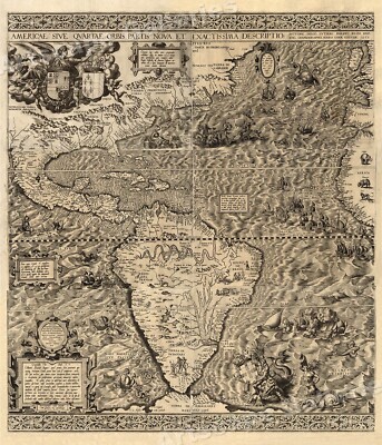
$5.95 Shipping Condition: New Location: Las Vegas, United States The New World 1562 Size: 20" x 24" 51 cm x 61 cm) x Also Available in 24" x 28" from our eBay Store This is a great Classic Map originally ... morePublished circa 1562. This Map shows the America's as it was known in the 1500's. Includes texts in cartouche. Statements of dedication, coats-of-arms, ill. of allegorical f igure"Victoria" And ill. of sailing ships at sea and imaginary marine creatures. The wording on the map reads: Americae sive qvartae orbis partis nova et exactissima descriptio/ avtore Diego Gvtiero Philippi Regis Hisp. etc. Cosmographo; Hiero. Cock excvde 1562; Hieronymus Cock excude cum gratia et priuilegio 1562" This poster. Which evokes the vivid images of a simpler time, is a custom reproduction printed on 68lb Heavyweight Enhanced Matte Art Paper. This Historic Art Print is suitable for framing. Mounting or direct display on any wall! 000 Artscape Galleries/ Posters Past More Prints and Posters Available from our eBay Store! Shipping price includes delivery confirmation. We combine shipping for multiple purchases- add $1.00 for each additional poster. All posters are professionally packaged to ensure that they arrive safely and undamaged: Your poster is first rolled and inserted into a plastic sleeve before being placed into a Heavy-Duty mailing tube for delivery. We stand behind the quality of every poster. If you are not satisfied with your purchase. Please contact us within 30 days to arrange for either an exchange or a full refund. gsrx_vers_468(GS 6.4(468)
Buy It Now
$5.95 Shipping Condition: New Location: Las Vegas, United States Year: 1570. Each of our prints are custom reproductions printed on 68lb Heavyweight Enhanced Matte Art Paper. These Historic Art Prints are suitable for ... moreframing, mounting or direct display on any wall!
Buy It Now
$5.95 Shipping Condition: New Location: Las Vegas, United States Year: 1565. Universale Descrittione di Tutta la Terra Conoscivta fin Qui. “Vibrant and bright! Pic does not do it justice.looks amazing!”. Each of our ... moreprints are custom reproductions printed on 68lb Heavyweight Enhanced Matte Art Paper.
Buy It Now
$5.95 Shipping Condition: New Location: Las Vegas, United States This is a wonderfully detailed World Map by Frederic de Wit originally created in 1660. The bottom center illustrates two astronomical diagrams - a geocentric ... moreone on the left and a Copernican on the right.
Buy It Now
$5.95 Shipping Condition: New Location: Las Vegas, United States Orbis Terrarum - Italy. This map (Italiae Novissima) is a view of Italy in the late 16th century! Year: 1570. Each of our prints are custom reproductions ... moreprinted on 68lb Heavyweight Enhanced Matte Art Paper.
Buy It Now
$5.95 Shipping Condition: New Location: Las Vegas, United States Year: 1774. Each of our prints are custom reproductions printed on 68lb Heavyweight Enhanced Matte Art Paper. These Historic Art Prints are suitable for ... moreframing, mounting or direct display on any wall!

Buy It Now
$5.95 Shipping Condition: New Location: Las Vegas, United States Universale Descrittione di Tutta la Terra Conoscivta fin Qui- 1565 Size: 14" x 24" 36 cm x 61 cm) x Also Available in 24" x 40" 14" ... morex 24" from our eBay Store This is a great Classic Map originally Published circa 1565. This Map. Etched by Fernando Bertelli was based on an earlier map by Giacomo Gastaldi. It shows the world as it was known in the mid 1500's. This poster. Which evokes the vivid images of a simpler time, is a custom reproduction printed on 68lb Heavyweight Enhanced Matte Art Paper. This Historic Art Print is suitable for framing. Mounting or direct display on any wall! 000 Artscape Galleries/ Posters Past More Prints and Posters Available from our eBay Store! Shipping price includes delivery confirmation. We combine shipping for multiple purchases- add $1.00 for each additional poster. All posters are professionally packaged to ensure that they arrive safely and undamaged: Your poster is first rolled and inserted into a plastic sleeve before being placed into a Heavy-Duty mailing tube for delivery. We stand behind the quality of every poster. If you are not satisfied with your purchase. Please contact us within 30 days to arrange for either an exchange or a full refund. gsrx_vers_468(GS 6.4(468)
Buy It Now
$5.95 Shipping Condition: New Location: United States Year: 1585. The Voyages of Sir Francis Drake. This great Historic Map print shows Sir Francis Drake's voyage to the new world during his West Indian voyage ... moreof 1585-1586. “Vibrant and bright! Pic does not do it justice.looks amazing!”.
Buy It Now
$5.95 Shipping Condition: New Location: Las Vegas, United States Year: 1585. “Vibrant and bright! Pic does not do it justice.looks amazing!”. Beautiful map! Each of our prints are custom reproductions printed on 68lb ... moreHeavyweight Enhanced Matte Art Paper. These Historic Art Prints are suitable for framing, mounting or direct display on any wall!
Buy It Now
$5.95 Shipping Condition: New Location: Las Vegas, United States Year: 1627. Each of our prints are custom reproductions printed on 68lb Heavyweight Enhanced Matte Art Paper. These Historic Art Prints are suitable for ... moreframing, mounting or direct display on any wall!

Buy It Now
$5.95 Shipping Condition: New Location: Las Vegas, United States The Voyages of Sir Francis Drake 1585- Santiago Cape Verde Islands Size: 24" x 32" 61 cm x 81 cm) x Also Available in 18" x 24" from ... moreour eBay Store This is a great Classic Map originally published circa 1589. This Map shows Sir Francis Drake's voyage to Santiago. Cape Verde Islands during his West Indian voyage of 1585-1586. This map is a vintage stylistic print of the time. Featuring a swimming sea monster. A large flying fish and a man- ape creature. This poster. Which evokes the vivid images of a simpler time, is a custom reproduction printed on 68lb Heavyweight Enhanced Matte Art Paper. This Historic Art Print is suitable for framing. Mounting or direct display on any wall! 000 Artscape Galleries/ Posters Past More Prints and Posters Available from our eBay Store! Shipping price includes delivery confirmation. We combine shipping for multiple purchases- add $1.00 for each additional poster. All posters are professionally packaged to ensure that they arrive safely and undamaged: Your poster is first rolled and inserted into a plastic sleeve before being placed into a Heavy-Duty mailing tube for delivery. We stand behind the quality of every poster. If you are not satisfied with your purchase. Please contact us within 30 days to arrange for either an exchange or a full refund. gsrx_vers_468(GS 6.4(468)
Buy It Now
$5.95 Shipping Condition: New Location: Las Vegas, United States Year: 1849. Lengths of the Principal Rivers in the World Heights of the Principal Mountains in the World. This great Historic Map print shows the "Lengths ... moreof the Principal Rivers in the World" and the "Heights of the Principal Mountains in the World" by way of an index and graphical representation.
Buy It Now
$5.95 Shipping Condition: New Location: Las Vegas, United States Year: 1703. Each of our prints are custom reproductions printed on 68lb Heavyweight Enhanced Matte Art Paper. These Historic Art Prints are suitable for ... moreframing, mounting or direct display on any wall!
Buy It Now
$1.63 Shipping Location: Nashville, United States Up for sale is an original antique 1837 MAP OF THE STATE OF ILLINOIS. In very nice Original antique condition. I think maybe I was the first to ever unfold ... morethe map. Would make a wonderful gift. Quite scarce.
Buy It Now
$21.16 Shipping Location: SUTTON COLDFIELD, United Kingdom MAGNIFICENT LARGE HARDBACK MAP. ABOUT THIS MAP. CONDITION: Excellent condition perfectly preserved in the archives.
Buy It Now
Free Shipping Location: Nashville, United States Up for sale is a Beautiful 1905 Color GEOLOGIC MAP OF VICINITY OF JUNEAU, ALASKA, 18” X 21.5”. This historical map was salvaged from a 1905 U.S. Army ... moreCorp Of Engineers Book. In beautiful antique condition.
Buy It Now
$5.95 Shipping Condition: New Location: Las Vegas, United States Sir Francis Drake's voyages - Vera Totius Expeditionis Nautica. Year: 1595. Each of our prints are custom reproductions printed on 68lb Heavyweight Enhanced ... moreMatte Art Paper. These Historic Art Prints are suitable for framing, mounting or direct display on any wall!
Buy It Now
$5.95 Shipping Condition: New Location: Las Vegas, United States Orbis Terrarum - Palestine. Year: 1570. “Vibrant and bright! Pic does not do it justice.looks amazing!”. Each of our prints are custom reproductions printed ... moreon 68lb Heavyweight Enhanced Matte Art Paper.
Buy It Now
$5.95 Shipping Condition: New Location: Las Vegas, United States Nova et Accuratissima Totius Terrarum Orbis Tabula. Year: 1664. Each of our prints are custom reproductions printed on 68lb Heavyweight Enhanced Matte ... moreArt Paper. These Historic Art Prints are suitable for framing, mounting or direct display on any wall!
Buy It Now
$5.95 Shipping Condition: New Location: Las Vegas, United States This great Historic Map print shows the British Empire throughout the world exhibited in one view. Year: 1850. British Empire throughout the World exhibited ... morein one view. Each of our prints are custom reproductions printed on 68lb Heavyweight Enhanced Matte Art Paper.
Buy It Now
$5.95 Shipping Condition: New Location: Las Vegas, United States Lengths of the Principal Rivers in the World Heights of the Principal Mountains in the World. This great Historic Map print shows the "Lengths of the ... morePrincipal Rivers in the World" and the "Heights of the Principal Mountains in the World" by way of an index and graphical representation.
Buy It Now
$5.95 Shipping Condition: New Location: Las Vegas, United States Year: 1799. A new map of the world : with all the new discoveries by Capt. Cook. Each of our prints are custom reproductions printed on 68lb Heavyweight ... moreEnhanced Matte Art Paper. These Historic Art Prints are suitable for framing, mounting or direct display on any wall!

Buy It Now
$5.95 Shipping Condition: New Location: Las Vegas, United States The Voyages of Sir Francis Drake 1585- Cartagena Columbia Size: 24" x 32" 61 cm x 81 cm) x Also Available in 18" x 24" from our eBay ... moreStore This is a great Classic Map originally published circa 1589. This Map shows Sir Francis Drake's voyage to the city of Cartagena. Columbia during his West Indian voyage of 1585-1586. This map is a vintage stylistic print of the time featuring a sea monster trying to catch a flying fish and a large lizard. This poster. Which evokes the vivid images of a simpler time, is a custom reproduction printed on 68lb Heavyweight Enhanced Matte Art Paper. This Historic Art Print is suitable for framing. Mounting or direct display on any wall! 000 Artscape Galleries/ Posters Past More Prints and Posters Available from our eBay Store! Shipping price includes delivery confirmation. We combine shipping for multiple purchases- add $1.00 for each additional poster. All posters are professionally packaged to ensure that they arrive safely and undamaged: Your poster is first rolled and inserted into a plastic sleeve before being placed into a Heavy-Duty mailing tube for delivery. We stand behind the quality of every poster. If you are not satisfied with your purchase. Please contact us within 30 days to arrange for either an exchange or a full refund. gsrx_vers_468(GS 6.4(468)
Buy It Now
$13.73 Shipping Location: MANCHESTER, United Kingdom Daniel Lizars Sr. (1754-1812) was the son of a shoemaker, but he apprenticed with Andrew Bell, a printer and engraver. The map is printed on good quality ... morethick paper.
Buy It Now
$5.95 Shipping Condition: New Location: Las Vegas, United States Orbis Terrarum - Middle East. This map (Tvrcici Imperii Descripto) is a view of Middle East in the late 16th century! Year: 1570. Each of our prints are ... morecustom reproductions printed on 68lb Heavyweight Enhanced Matte Art Paper.
Buy It Now
$5.95 Shipping Condition: New Location: Las Vegas, United States The Voyages of Sir Francis Drake 1585- Cartagena Columbia Size: 18" x 24" 46 cm x 61 cm) x Also Available in 24" x 32" from our eBay ... moreStore This is a great Classic Map originally published circa 1589. This Map shows Sir Francis Drake's voyage to the city of Cartagena. Columbia during his West Indian voyage of 1585-1586. This map is a vintage stylistic print of the time featuring a sea monster trying to catch a flying fish and a large lizard. This poster. Which evokes the vivid images of a simpler time, is a custom reproduction printed on 68lb Heavyweight Enhanced Matte Art Paper. This Historic Art Print is suitable for framing. Mounting or direct display on any wall! 000 Artscape Galleries/ Posters Past More Prints and Posters Available from our eBay Store! Shipping price includes delivery confirmation. We combine shipping for multiple purchases- add $1.00 for each additional poster. All posters are professionally packaged to ensure that they arrive safely and undamaged: Your poster is first rolled and inserted into a plastic sleeve before being placed into a Heavy-Duty mailing tube for delivery. We stand behind the quality of every poster. If you are not satisfied with your purchase. Please contact us within 30 days to arrange for either an exchange or a full refund. gsrx_vers_468(GS 6.4(468)
Buy It Now
$5.95 Shipping Condition: New Location: United States Year: 1585. “Vibrant and bright! Pic does not do it justice.looks amazing!”. Beautiful map! Each of our prints are custom reproductions printed on 68lb ... moreHeavyweight Enhanced Matte Art Paper. These Historic Art Prints are suitable for framing, mounting or direct display on any wall!
Buy It Now
$5.95 Shipping Condition: New Location: Las Vegas, United States This early 17th Century World Map shows the Old World and the New as it was known in 1608. Year: 1608. Each of our prints are custom reproductions printed ... moreon 68lb Heavyweight Enhanced Matte Art Paper.

Buy It Now
$5.95 Shipping Condition: New Location: Las Vegas, United States The Voyages of Sir Francis Drake 1585 Size: 24" x 32" 61 cm x 81 cm) x Also Available in 18" x 24" from our eBay Store This is a great ... moreClassic Map originally published circa 1589. This Map shows Sir Francis Drake's voyage to the new world during his West Indian voyage of 1585-1586. This map is a vintage stylistic print of the time and features his voyage from Europe to ports in South America. The Caribbean and North America. This poster. Which evokes the vivid images of a simpler time, is a custom reproduction printed on 68lb Heavyweight Enhanced Matte Art Paper. This Historic Art Print is suitable for framing. Mounting or direct display on any wall! 000 Artscape Galleries/ Posters Past More Prints and Posters Available from our eBay Store! Shipping price includes delivery confirmation. We combine shipping for multiple purchases- add $1.00 for each additional poster. All posters are professionally packaged to ensure that they arrive safely and undamaged: Your poster is first rolled and inserted into a plastic sleeve before being placed into a Heavy-Duty mailing tube for delivery. We stand behind the quality of every poster. If you are not satisfied with your purchase. Please contact us within 30 days to arrange for either an exchange or a full refund. gsrx_vers_468(GS 6.4(468) Jy.RcmdId ViewItemDescV4,RlogId p4%60bo7%60jtb9%3Fuk%601d72f%2Bkw4sjm5%3Ejy-13db69ec104-0xfd-
Buy It Now
$5.95 Shipping Condition: New Location: Las Vegas, United States Orbis Terrarum - Asia. This map (Asiae Nova Desciptiq) is a view of Asia in the late 16th century! Year: 1570. Each of our prints are custom reproductions ... moreprinted on 68lb Heavyweight Enhanced Matte Art Paper.
Buy It Now
$5.95 Shipping Condition: New Location: United States Year: 1585. “Vibrant and bright! Pic does not do it justice.looks amazing!”. Beautiful map! Each of our prints are custom reproductions printed on 68lb ... moreHeavyweight Enhanced Matte Art Paper. These Historic Art Prints are suitable for framing, mounting or direct display on any wall!
Buy It Now
$5.95 Shipping Condition: New Location: Las Vegas, United States Orbis Terrarum - Palestine. Year: 1570. Each of our prints are custom reproductions printed on 68lb Heavyweight Enhanced Matte Art Paper. These Historic ... moreArt Prints are suitable for framing, mounting or direct display on any wall!
Buy It Now
$5.95 Shipping Condition: New Location: Las Vegas, United States Mappemonde a l'usage du Roy Size: 24" x 36" 61 cm x 91 cm) x Also Available in 16" x 24" from our eBay Store This is a great Classic ... moreMap originally Published circa 1720. This Map. By Guillaume Delisle, shows The known world of the early 1700's. This poster. Which evokes the vivid images of a simpler time, is a custom reproduction printed on 68lb Heavyweight Enhanced Matte Art Paper. This Historic Art Print is suitable for framing. Mounting or direct display on any wall! 000 Artscape Galleries/ Posters Past More Prints and Posters Available from our eBay Store! Shipping price includes delivery confirmation. We combine shipping for multiple purchases- add $1.00 for each additional poster. All posters are professionally packaged to ensure that they arrive safely and undamaged: Your poster is first rolled and inserted into a plastic sleeve before being placed into a Heavy-Duty mailing tube for delivery. We stand behind the quality of every poster. If you are not satisfied with your purchase. Please contact us within 30 days to arrange for either an exchange or a full refund. gsrx_vers_468(GS 6.4(468)
Buy It Now
$5.95 Shipping Condition: New Location: Las Vegas, United States Orbis Terrarum - Germany. This map (Germania) is a view of Germany in the late 16th century! Year: 1570. “Vibrant and bright! Pic does not do it justice.looks ... moreamazing!”. Each of our prints are custom reproductions printed on 68lb Heavyweight Enhanced Matte Art Paper.
Buy It Now
$5.95 Shipping Condition: New Location: Las Vegas, United States It was the first map, printed or manuscript, to depict clearly a separate Western Hemisphere, with the Pacific as a separate ocean. Year: 1507. Each of ... moreour prints are custom reproductions printed on 68lb Heavyweight Enhanced Matte Art Paper.
Buy It Now
$5.95 Shipping Condition: New Location: Las Vegas, United States Year: 1640. Also shows a fanciful inset of Australia that is large enough to reach the south pole! “Vibrant and bright! Pic does not do it justice.looks ... moreamazing!”. Each of our prints are custom reproductions printed on 68lb Heavyweight Enhanced Matte Art Paper.
Buy It Now
$5.95 Shipping Condition: New Location: Las Vegas, United States Orbis Terrarum - England, Scotland, and Ireland. This map (Angliae, Scotiae, et Hiberniae) is a view of England, Scotland, and Ireland in the late 16th ... morecentury! Year: 1570. Each of our prints are custom reproductions printed on 68lb Heavyweight Enhanced Matte Art Paper.
Buy It Now
$5.95 Shipping Condition: New Location: Las Vegas, United States Year: 1716. This great Historic Map print shows a beautifully detailed map of the world as it was known in 1716 published by Johann Baptist Homann. Each ... moreof our prints are custom reproductions printed on 68lb Heavyweight Enhanced Matte Art Paper.
Buy It Now
$5.95 Shipping Condition: New Location: Las Vegas, United States Year: 1680. “Vibrant and bright! Pic does not do it justice.looks amazing!”. Each of our prints are custom reproductions printed on 68lb Heavyweight Enhanced ... moreMatte Art Paper. These Historic Art Prints are suitable for framing, mounting or direct display on any wall!
Buy It Now
$5.95 Shipping Condition: New Location: Las Vegas, United States Orbis Terrarum - Italy. This map (Italiae Novissima) is a view of Italy in the late 16th century! Year: 1570. “Vibrant and bright! Pic does not do it ... morejustice.looks amazing!”. Each of our prints are custom reproductions printed on 68lb Heavyweight Enhanced Matte Art Paper.
Buy It Now
$5.95 Shipping Condition: New Location: Las Vegas, United States “Vibrant and bright! Pic does not do it justice.looks amazing!”. Each of our prints are custom reproductions printed on 68lb Heavyweight Enhanced Matte ... moreArt Paper. These Historic Art Prints are suitable for framing, mounting or direct display on any wall!
Buy It Now
$5.95 Shipping Condition: New Location: Las Vegas, United States Year: 1705. An interesting decorative historical map of the world showing California as an island with an undefined coast of Australia. Each of our prints ... moreare custom reproductions printed on 68lb Heavyweight Enhanced Matte Art Paper.
Buy It Now
$5.95 Shipping Condition: New Location: United States Year: 1585. The Voyages of Sir Francis Drake - Santo Domingo. This great Historic Map print shows Sir Francis Drake's voyage to the city of what is now ... moreSanto Domingo, Dominican Republic during his West Indian voyage of 1585-1586.
Buy It Now
$51.37 Shipping Location: Granger, United States This antique atlas map by Johnson and Ward is a stunning addition to any collection. The map is an original antique and is in excellent condition. Its ... moreyear of publication is 1860s adding to its historical significance.
Buy It Now
$4.21 Shipping Location: Blanco, United States
|
|
|
|
LARGE FINE "HISTORICAL MAPS OF EUROPE" BOOK! PUBLISHED IN 2000
DO NOT DELAY YOUR BID IF YOU REALLY WANT IT!I WILL NOT BE RE-LISTING! I WILL POST THIS ITEM TO ANYWHERE IN THE. U.K. E.U, OR U.S/CHINA ONLY U.K- £5 E.U COUNTRIES: £20 U.S/CAN/AUS/CHINA: £25 THANKS ~~~~~~~~~~~~~~~~~~~~~~~~~~~~~~~~~~~~~~~~~~~~~~~~~~~~~~~~~~~~~~~~~ THIS LOT COMPRISES A. LARGE. FINE, AND RATHER PLUSH. HISTORICAL MAPS OF EUROPE" BOOK! IT WAS PUBLISHED IN 2000, AND IS IN VERY GOOD CONDITION. WITH ITS DUSTJACKET. THIS IS AN INDESPENSIBLE BOOK IF YOU ARE INTERESTED IN HISTORIC MAPS, OR ARE A MAP COLLECTOR. AND A SUPERB ADDITION. TO YOUR MAP COLLECTION. PLEASE LOOK AT ALL OF THE 3 PICTURES I HAVE LISTED. AND ASK ANY QUESTIONS. DON'T MISS IT! PLEASE NOTE: I WILL NOT BE RE-LISTING THIS ITEM! SO.DO NOT DELAY YOUR BID IF YOU REALLY WANT IT! ~~~~~~~~~~~~~~~~~~~~~~~~~~~~~~~~~~~~~~~~~~~~~~~ PLEASE READ THE FOLLOWING ... moreVERY CAREFULLY BEFORE BIDDING AS I WILL NOT DEVIATE FROM MY TERMS IN ANY WAY WHATSOEVER. MY TERMS OF SALE ARE. 1. FULL PAYMENT TO BE MADE VIA PAYPAL ONLY AFTER THE SALE. FULL PAYMENT TO HAVE BEEN RECEIVED WITHIN 48 HOURS. OTHERWISE THE ITEM WILL GO STRAIGHT TO THE UNDERBIDDER. 2. I POST WITHIN THE NEXT 3 DAYS AFTER RECEIVING PAYMENT IF I AM ABLE TO. HOWEVER. IF PERSONAL CIRCUMSTANCES PREVENT THIS, THEN I CANNOT GUARANTEE THIS. 3. I ACCEPT PAYPAL ONLY. 4. FEEDBACK WILL BE RECIPROCATED. 5. ALL POSTAGE RECEIPTS ARE RETAINED AS PROOF OF POSTAGE. ~~~~~~~~~~~~~~~~~~~~~~~~~~~~~~~~~~~~~~~~~~~~~~~~ THE ITEM WILL BE VERY WELL WRAPPED AND PACKAGED AND POSTED BY ROYAL MAIL. THANKS FOR READING!
|
|
|
1875 ILLUSTRATED HISTORICAL ATLAS IOWA STATE 216 maps lithographs Andreas A45
Coins of India Reference Library This CD is part of our Historic Atlas Collection. We have dozens of Atlas maps on CD ranging from the 1500s to the 1900s covering many areas and topics. Please Check our Ebay Store for what's available. VERY LARGE HIGH RESOLUTION MAP COLLECTION ON CD-ROM! please see full table of contents and sample illustrations below) Title of this Atlas: A.T. Andreas' Illustrated Historical Atlas of the State of Iowa(7th Congressional District ed. Published by the Andreas Atlas Co. Lakeside Building, Chicago, Ills. Engraved& printed by Chas. Shober& Co. Props. of Chicago Lithographing Co. 1875 Features of this CD-ROM This auction is for a CD-ROM of the maps listed in electronic form. NOT the maps themselves. These maps are VERY high resolution and can be printed at FULL SCALE or LARGER for framing and display. ... moreThe results are very high quality and convincing The files are in PDF format for easy of viewing and printing. Maps can be viewed and many scales and zoom features are available as with any PDF file. 0018001 Davenport. Iowa, as seen from south west. 0018002 Title Page: A.T. Andreas' illustrated hist. atlas of the State of Iowa, 0018003(Portraits of) Cyrus C. Carpenter. Governor, W.M. Stone, Chester C. Cole, William E. Miller, John F. Dillon, Josiah T. Young, Caleb Baldwin, Oliver Mills, Alonzo Abernethy, David Secor, H.O. Pratt, B.F. Gue, G.F. Magoun. Chas. Shober& Co. props. Chicago Litho. Co. 0018004 Council Bluffs. Iowa from north; residences in E. Des Moines& Council Bluffs. 0018005 Geological map of the State of Iowa. Climatological map of the State of Iowa. 0018006 Western Hemisphere. 0018007 Eastern Hemisphere. 0018008 Maps of the State of Iowa showing representative districts. Senatorial districts. 0018009 Maps of the State of Iowa showing congressional districts. Judicial districts. 0018010 Atlantic. Iowa; farms& bldgs. Cass Co. Davenport, Altoona, Chariton& Albia. 0018011 Herd. Residences, buildings& churches, W. Liberty, Mt. Vernon, Decor
|
|
|
Italy: THREE Authentic 1889 Maps showing "Modern" & Historical w/ Cites Topog.
Authentic 1889 Color Maps Lot of Three Maps of Italy Territorial Divisions of[Modern(1889) Italy; Italy Previous to 1797; Ancient Italy. Time of Augustus to Constantine Satisfaction Guaranteed Please scroll down to see individual scans of the three maps This lot of three color maps of Italy was included in Encylopaedia(Encyclopedia) Britannica's Ninth Edition as published in 1889 by the New York publisher Charles Scribner's Sons. These are genuine 1889 maps-NOT reproductions. The maps are printed on medium weight paper-blank on the reverse. Each sheet size is about 10.5" x 8" And the scans are only slightly cropped. Condition is very good-as shown. Territorial Divisions of Italy: Italy Previous to 1797: Ancient Italy. Time of Augustus to Constantine: Maps are identified on the face as being from Britannica's Ninth Edition ... morewhich was published by a number of publishers over a period of years-primarily between 1885 and 1889. Bid with confidence- Returnable for any reason within 10 days for prompt refund. Powered by The free listing tool. List your items fast and easy and manage your active items.
|
|
|
VINTAGE 1943~HC ~COLLIER'S WORLD ATLAS /GAZETTEER~HISTORICAL INTERNATIONAL MAPS~
VINTAGE + COMPLETE HC"COLLIER'S WORLD ATLAS& GAZETTEER" 1943~FULLY-ILLUATRATED~MAPS OF the WORLD~CITY MAPS~THE FINEST MOST ACCURATE GEOGRAPHICAL.STATISTICAL& HISTORICAL 336 pg BOOK~*VERY GOOD ANTIQUE CONDITION~VIEW PICS BID w/CONFIDENCE SOLD ANTIQUES ONLINE 13 yr~COMBINE WORLDWIDE SHIPPING~HISTORICAL ANTIQUE BOOK.
|
|
|
Ca 1955 ISRAEL ATLAS GEOGRAPHICAL HISTORICAL MAPS book
You are looking at a VINTAGE. From Circa 1955. ISRAELI ATLAS OF ISRAEL– GEOGRAPHICAL and HISTORICAL ATLAS of ERETZ-ISRAEL. PUBLISHED BY THE ISRAELI ARMY(I.D.F. Zahal) in Circa 1955(Data mentioned from Ca 1954) Hardcover. Numerous pages. Except old small moth holes(not active) Size: 14" 35 cm) by 9 1/4" 23 cm) Condition: Pages in Fair used condition. Cover is worn. VISIT MY eBay STORE- I AM SURE YOU WILL FIND ADDITIONAL ATTRACTIVE ITEMS FROM THE SAME AND OTHER CATEGORIES. Visit my home website in Israel: asfanisraeli.com(sorry. Hebrew only, but photos are very good) ITEM MUST BE PAID WITHIN: 10 DAY from the Purchase/ Auction Ending. PAYMENT METHOD: PAYPAL. SHIPPING: Shipping via REGISTERED AIRMAIL from Israel ONLY TO COUNTRIES THAT ISRAEL POST PROVIDES SERVICE TO. When possible. Shipping will be combined. Judaica Jewish Powered by ... moreThe free listing tool. List your items fast and easy and manage your active items.
|
|
|
1891 ILIFF'S IMPERIAL WORLD ATLAS"150 MAPS" ASTRONOMICAL,HISTORICAL,GEOGRAPHICAL
Iliff's Imperial Atlas of the World- 1891 containing over 150 color maps of the U.S. and the World. First edition atlas John W. Iliff married the daughter of noted Atlas and Map Publisher George F. Cram and made extensive use of Cram maps in this publication. As well as adding some unique ones. There also city plans, flags, coats of arms, tables, Statistics from 1890 Census and diagrams, etc. 319 pages in all. Many City Maps as you can see in the pictures, also comes with a chorological outline of American History from 986 to 1891. Also has a complete description of each State and territory in the United States and of each Country in the World. Condition: Atlas has some outer cover damage to cover corners and spine ends(please see pictures) But the rest of the Atlas is in very Good condition, the Maps and text is in very good condition. ... morePlease see pictures. Atlas is complete with all maps and text. Thanks for looking Posted with
|
|
|
1915 Folio Maps Photos/ Historical Commercial Development New York City & State
Industrial Review of New York 1915 Part of a large collection of antique leather bound books offered this week in my eBay HERE. Very rare and vary limited edition. This was put together by the Chamber of Commerce(as a group) in a yearly review. It includes one of the best historical accounts of New York City. New York State's Industrial& Commercial development for the year of 1915 Its further includes detailed maps. And profuse half-tone illustrations from all parts of The Empire State. Containing in addition Statistical charts pertaining to the increased Cost of Living. Newly Engraved Maps. Of every state in the United States. Detailed maps of every Country State and Kingdom. Together with. A complete and adequate locating index of all cities. Towns, villages, and post offices in the United States giving population to every incorporated ... morecity and villages therein. Authors: Chamber of Commerce. Officials, and Public spirited Citizens of the State of New York Illustrations: Full color lithograph maps and half-tone images(photographs) Binding: Hard back Binding Material: Cloth on heavy board Boards: Paper- no decoration End-Papers: Yes- minor silver fish damage to first page along with ink signature in calligraphy. unreadable Publisher: George F. Cram Company Publication Date: 1915 Pages: 300 in high quality paper First Edition: True- no reprinting of each year Dust Jacket: N/A List rice: Unknown- no comparison available Estimates Value: $700- $1200 Height: 16.50 inches Width: 1.00 inches Length: 12.00 inches Weight: 1.50 pounds Condition: Pre-Owned. With edge damage to the cover. Binding is fair but slightly loose. No missing pages but I did notice a few minor edge chips and a little writing on 2 pages. Please review all photos as the description. Keywords: Empire State. Newyork, NJ, Demographical, Demographic, Analytical, Study, Historical, Reference, Map, Atlas, Delineation, Diagram, Draft, Drawing, Elevation, Globe, Graph, Outline, Print, Sketch, Topographical Depiction. ~Partial~
|
|
|
1800s & Up Indian Horses & Bridles Illust Historical Collector Ref w Color Maps
Search in Leavenworth-Consignment Search titles and descriptions Collector Bookstore 724 Delaware Street Leavenworth. KS 66048, Collector Bookstore is a leading specialty retailer of price guides and reference books to inform and educate collectors and professionals in the antiques and collectors markets. Our customers include individual collectors. Dealers, appraisers, auctioneers& other industry professionals. You won't receive heavily thumbed shelf copies from us! We buy most titles directly from the publisher and individual authors. Authors are encouraged to submit their reference titles for our consideration. HHP-2012-9780965994774-X17 ISBN: 9780965994774, Book Title: Horses and Bridles of the American Indian, Author: Mike Cowdrey. Ned Martin, Jody Martin, Binding: Hard Cover with dust jacket, Copyright: 2012, Pages: 220, Size: ... more13.75 x 12.25 in. This item will NOT fit in a flat rate envelope. Collector Bookstore is a retailer of new books located in Leavenworth. Kansas. We specialize in price guides and reference books for the antiques and collectibles industry. In this volume. For the first time in one source, is the historical documentation showing approximately when and from where the first horses reached more than 125 tribes. Elegant, full- color maps, show this parade across the continent. The introduction of the horse changed Indian culture, and caused a revolution in lifestyle. American Indian tribes bridled their horses in unique and beautiful ways. Their fancy beaded. Quilled and cloth bridles are featured in more than 600 color photographs, paintings and historic images. Of materials taken from the depths of the sea and the bowels of the earth; from birds of the sky; plants, trees and creatures of the land; from the scalps and bodies of defeated enemies and the manes and tails of the steeds themselves, Native artisans designed myriad ways to transform the appearance of their beloved horses. Jingling with bells, wrapped in rainbows, reined and stitched with lightning, for five centuries the
|
|
|
VINTAGE TRANSPORTATION / HISTORICAL MEMORABILIA / MAPS / UNITED STATES / DIXIE
This framed map is titled The United States of Dixie and is from The American Paper& Plastic Products. The map includes The Dixie Dictionary from Co Horsepasture's Guidebook and Dixie Dictionary 1966 by Tin' N Twinkle Inc. The map comes matted in wooden frame. Has color graphics, measures 15 3/4 x 11 1/4 inches, has minor foxing, but looks great and would add to any collection. Please note that all my listed items are from garage. Estate sale, or thrift stores and not listed as new, unless specified. I always try to describe the item as truthfully as possible; but may not always detect every flaw. Please contact me if not completely satisfied with item to resolve any issues or concerns.Thank You!
|
|
|
Vintage Historical GERMAN Maps Travel Guides 1936 BERLIN Summer Olympics Germany
This is a set of three different guide books with fold out maps for three regions of Germany: THE RHINE. NUREMBERG AND FRANCONIS, NORTH-WEST( HANSEATIC CITIES AND NORTH SEA BATHING RESORTS) Each guide book measures@9" length All three advertise the upcoming 1936 Olympics in Berlin Excellent condition with only a minor blemish of two- no tears or stains On Feb-27-13 at 07:42:19 PST. Seller added the following information:
|
|
|
US Army Manual Russian Combat Methods Field HIstorical Study WWII 1950 w/ 9 maps
US Army Manual Russian Combat Methods Field HIstorical Study WWII 1950 with 9 pullout multi-color maps with battle lines emphasized. In very good condition. Shows a little wear, all 9 pull out maps are in great shape.Army Pamphlet No.20-230 original Korean War era issued restricted guide.116 pages.
|
|
|
HISTORICAL 1950 METSKERS ATLAS MAPS PACIFIC COUNTY WA RAYMOND SO BEND ILWACO ETC
THIS IS A" HUGE" VINTAGE HISTORICAL COMMERCIAL SIZE 18-1/4" X 14-1/2" ~" 1950" METSKER'S ATLAS OF PACIFIC COUNTY WASHINGTON WITH A LEATHERETTE TYPE JACKET COVER ~ HAD 37 PAGES(PAGE# 34 APPEARS TO BE MISSING WHICH COVERED A SMALL AREA FROM OCEAN PARK TO SEALAND) PAGE#1 IS A FULL PAGE MAP OF PACIFIC COUNTY WASHINGTON LISTING THE TOWNS& CITIES ~ PAGE#2 IS THE INDEX PAGE WITH 34 PAGES FOLLOWING OF MAPS& DESCRIPTIONS ~ THE PAGE#1 SHOWS THE MOST MARGIN EDGE WEAR& YELLOWING FROM AGE ~ ALSO THERE IS SOME END PAGE SOILING& DISCOLORATION AS SHOWN IN MY PICTURES ~ THESE HISTORICAL COMMERCIAL SIZE OLD COUNTY METSKER'S ATLAS MAPS ARE USED BY REALTORS. LAND DEVELOPERS& SPECULATORS, SURVEYORS, LOGGERS, ATTORNEYS& HISTORIANS ~ THE LARGER CITIES LISTED ON THE MAP IN PACIFIC COUNTY WASHINGTON ARE ... moreRAYMOND, SOUTH BEND, ILWACO, SEAVIEW, LONG BEACH, OCEAN PARK, NAHCOTTA, CHINOOK, MEGLER, NASELLE, DEEP RIVER AND MANY MORE SMALLER TOWNS ~ WHAT YOU SEE ~ IS WHAT YOU GET. ALL SALES FINAL~PAYMENT IS EXPECTED WITHIN 4 DAYS AFTER AUCTION ENDS ~NOTE!$$ POSTAGE$$ I will GLADLY combine items TO SAVE YOU$$$~PLEASE ALSO NOTE!I RESERVE THE OPTION TO CANCEL ANY ACTIVE LISTING WITHOUT BIDS~SO~I SUGGEST THAT YOU PLACE A BEGINNING BID. IF YOUR INTERESTED IN ANY OF MY LISTED ITEMS~INTERNATIONAL BUYERS, ASK FOR SHIPPING QUOTE BEFORE BIDDING& YOU ARE RESPONSIBLE FOR ANY CUSTOMS DUTY~ALSO~THE SHIPPING CALCULATOR MAY BE WRONG~WAIT FOR MY UPDATED INVOICE BEFORE PAYING.
|
|
|
Putnam's Historical Atlas Mediaeval & Modern 1927 Muir 96 Plates 223 Color Maps
This is a 6th"completely reconstructed and greatly enlarged" edition copy of"Putnam's Historical Atlas: Mediaeval and Modern. a 228 page, 9"x11.25" hardcover by Ramsay Muir and George Philip. It was published by G.P. Putnam's Sons in 1927. It contains"a series of 96 plates, containing 229 colored maps and diagrams: with a section on the economic history of the United States illustrated by 9 maps in black and white; an introduction illustrated by 40 maps and plans in black and white; and a complete index. It's in acceptable, reading-only condition, with no dust jacket. The dark blue cloth cover has quite a bit of wear, particularly along the edges wear it's fraying at various spots. The back has wax stains and scuffs. The interior has yellowed, the previous owner's name is written in pen on ... morethe inside front cover and inside back cover, and there's at least one other page with pen marks in the margins. The binding feels a little loose
|
|
|
THE BATTLE FOR KHE SANH,HISTORICAL STUDY,1969 Vietnam War w/maps illustrated
THE BATTLE FOR KHE SANH.HISTORICAL STUDY,1969 Vietnam War w/maps illustrated.203 pages.In great shape. Clean and straight, showing very light wear.
|
|
|
Mexico Panama Cuba - Rare Original 1911 Historical Antique World Atlas Maps
Three beautiful colored maps coming from the original 1911 Cram's Unrivaled Atlas of the World(New Census Edition) 102 years old! 100% Original and Authentic. Gorgeous maps featuring the Country of Mexic o on one side along with maps of Cuba and the Republic of Panama on the other. Both map include an incredible amount of detail. Map shows cities. Roads, rivers and topography in great detail. Shows all the major landmarks and cities in one of the worlds most historic places. Mexico Map Measure 22" X 15" Cub a Map Measure s 15" X 11" Republic of Panama Map Mea sures 15" X 11" Please see pictures for con dition detail. It is ready to frame and would look great on the wall of your office or study. Would make a great gift! Will ship in a tube. I have the entire World Atlas available and as it has fallen apart ... moreI will be separating it and selling the maps individually so they can be enjoyed. If you are interested in any particular States or Countries please let me know. RcmdId ViewItemDescV4,RlogId p4%60bo7%60jtb9%3Fv%7F.rpn37%3E-13d4e2d9687-0x100-
|
|
|
Vol 1 - 3 Historical Atlas of Canada Maps of Shipping, Natives, Exploration +
AZBookNook*NEW STOCK ADDED DAILY* Books are ex-library(University) with usual markings. NO rips or tears. No dust jackets. Clean cover and pages. Bindings are tight. Kept in reference section. Remain very clean. Set includes volume 1- 3. Covers maps, information from the beginning to 1967. Oversized 15 by 11 inches. We have other Canadian history books in our ebay store and ready to be listed. Check my other items up for auction and in our store. Bookmark AZBookNook and check back often as I am always adding new. Unique, one-of-a-kind, quality books at a good value! International customers. More than one book can often be shipped in a flat rate box. Bid with Confidence If book is not as described. Contact me within three days for full refund. Return postage responsibility of bidder. Q4)
|
|
|
HISTORICAL..OLD MAPS...SIGN
IF U COLLECT.BUY OR SELL OLD MAPS.HERE'S A PIECE OF RUSTIC WALL DECOR FOR YOUR SHOP.BOOTH.OR DEN.MEASURES OUT AT APPROX 6X24 INCHES
|
|
|
1875 antique DAUPHIN COUNTY PA HISTORICAL ATLAS color maps EVERTS & STEWART
VACATIONX] We combine shipping charges on multiple winning bids. Check out my other listings. save $$$: on eBay. 1875 antique DAUPHIN COUNTY PA HISTORICAL ATLAS color maps EVERTS& STEWART Atlas is 14 1/2 X 17 1/2" with embossed cloth and cover with leather corners and spine. Gilt title letters. With J.L. Smith Map publisher, Philadelphia PA store sticker inside front cover. There is a small, partially removed sticker on the title page as well. Combination Atlas Map of Dauphin County Pennsylvania Compiled. Drawn and Published from Personal Examinations and Surveys by Everts& Stewart. Philadelphia 1875. This is not a complete book as some pages were previously removed. There is some edge wear and some edge tears and chips. And some soiling and other antique wear with age. Mostly the pages have the wear on the edges. Front cover ... moreis detached but included. spine is damaged, and back cover is loosened. See photos. Here's what remains on 25 pages(still lots of great content) Title page, table of contents, 2 page map of the united states and territories, 2 page map of pennsylvania, 12 page history of dauphin county, errata, dauphin county court house. Harrisburg pa engraving, upper paxton map, telegraph building and cotton mill engraving, lower swatara map, cobaugh bro's paint work. Keystone tannery, commercial nurseries opposite penna& comberland rr. depot harisburg pa engraving, susquehanna township map, rush township map, 2 pages of engravings including the lochiel hotel, wiconisco/williams map, hoffman. Fanny herr, b. de vout, freck& co saw& planning mills engraving page, londonderry township map, swab. Kantz, j.l. matter merchant tailor, m.b. rambler engraving page, advertising page with map of gratz. Engraving of middletown furniture, advertising woodward singer sewing machines, silk twist, c.s. gilbert merchant tailor, geo. p. watson ice cream confectionary, cigars, etc. millersburg pa, swatara map, wiconisco ad millersburg maps, hummelstown map, dauphin. Uniontown, h alifax, berry
|
|
|
Vintage 1904 Fosters Historical Outline Maps For American History Book
Up for auction is this vintage 1904 Foster's Historical Outline Maps for Students of American History 79 page book. The book is in pretty good condition. All the pages are intact but there are a lot of notes written in the book and some of the maps have been colored, other than that pages show very minor wear, still interesting old maps to look at, cover shows minor wear. If you have any questions please email me. Good Luck!
|
|
|
State Maps - FORTS AND HISTORICAL AREAS OF FLORIDA (FL) (1513 - 1865) REPRINT 19
This is an exquisite full-color Reproduction printed on heavyweight(7.0 MIL) Glossy Photo Paper. These maps are perfect for framing. Or a wonderful and unique gift for family members, friends or co-workers! All Information is Carefully Compiled from Actual Surveys Original Maps are often difficult to find and usually have fold lines. Identifying stamps or markings, tears, ragged edges, and assorted other natural signs of age that detract from their beauty. All of our maps have been professionally restored to depict their original beauty, while keeping all historical data intact. These maps are fabulous pieces of history full of information useful to Historians. Genealogists, Cartographers, Relic Hunters, Others. They make fascinating conversation pieces and splendid works of art for the home or office. Map Size: 35.06 x 23 Site Specifics ... moreTo This Map Are: From Floridas waters. Beaches and harbors have come literally tons of treasure- Spanish Gold and Silver coins, jewlery and ornaments, as well as pirate treasures. Many millions have been recovered and reported. Shown here are some of the authenticated finds" with, in many instances, the names of the happy finders. Also shown are some of the recorded shipwrecks and other sources of treasure as yet undiscovered. These, too, have been authenticated. excerpt from map. This map Identifies and explains forts and other historical areas throughout Florida with an emphasis on possible buried treasure. Points of interest include the home of Harriet Beecher Stowe, Natural Bridge and cave where Indians hid from Jackson in 1818, where Billy Bowless privateer sunk here with $5 million in gold, where Narvez landed here in 1528 claiming land for Spain, where a vacationing couple picked up $10,000 in gold doubloons following a storm in 1945 plus many, many more. Map also includes an insert of important dates in Florida history. Finally, the border on this map beautifully illustrates different charcters throughout Floridas history- from Ponce De Leon to the Natives. The
|
|
|
DECORATIVE MAPS by Roderick Barron - Historical Antique Map Reproductions Folio
DECORATIVE MAPS by Roderick Barron Soft cover 1989- Historical Maps· Crescent Books 1989. ISBN: 0517688085. Folio(15" tall) BRAND NEW· 40 Beautiful color illustrated Historical Map Plates( 1300-1850- all parts of the world) Large page size- 15 x 11" Lavish descriptions of each map on back of plate· Included: Richard of Haldingham· The Hereford Mappa Mundi· Claudius Ptolemy· The World· Jean Rotz· Portolan Chart of South-East Asia· Diego Homem· Portolan Chart of the Atlantic· Laurence Nowell- A General Description of England& Ireland· Georg Braun& Frans Hogenberg· Francofordiae· Christopher Saxton- Dorcestriae· And many more Excellent Antique Map reference book or Great to separate and fame for display in your library or office! ALL SALES ARE FINAL ... more~ ANY QUESTIONS PLEASE ASK BEFORE BIDDING ~ THANKS FOR YOUR INTEREST Please Note: Acceptable form of payment: PayPal. Buyer to contact Seller within 24hours. Payment to be made within 2 days of auction end. Shipping: tracking and/or insurance/or both included. I will be glad to combine auction items for shipping purposes when feasible to save on Postage Fees when paid for on one invoice. If you are planning on purchasing multiple items. Please let me know so I can keep your items together. All purchases must be made within a 6-day period to qualify for combined shipping. There will be a $1. nominal fee for each additional item. Powered by The free listing tool. List your items fast and easy and manage your active items. 1.RcmdId ViewItemDescV4,RlogId p4%60bo7%60jtb9%3Fuk.rp73%28b0g%60%60%3E1-13d8fa1b2c2-0xcb-
|
|
|
wayne county iowa plat book 1897 w/maps replica by historical society local ads
its far from new but for age& usage. That shows, its still in pretty good shape. it has some bent corners the back is a bit dirty but there are no rips. the inside paper is crisp& clean with no rips, writing, or stains. the maps themselves are in particularly nice shape. great for collectors, geneology, or to frame individual maps. i dont know when it was put out by the wayne county historical society but long ago enough that the phone numbers are old enough to have only 5 numbers to dial. please take a look in my for more cool items from old america.thanks!
|
|
|
Two Different Historical Maps of Bradford County, Pennsylvania
Uploaded with[zipedit] Nannabooks Two Diff erent Historical Maps of Bradford County. Pennsylvania. Printed 1947. White one 30 Inches Wide. blue one slightly smaller. S turdy paper on white one. Blue one thinner paper. Very minimal discolo ration. Shipped as folded in Manila Envelope. Free First Class Shipping. +++++++++++++++++++++++++++++++++++++++++++ If your item is not deliverable and is returned because of your negligence in not managing your shipping address. You will be charged a re-stocking fee! Make sure your address is valid with Ebay and Paypal. If your address is not valid. And an address label will not print out through Ebay or Paypal sytems, I will refund you immediately and send a request to cancel the transaction. If your book is not deliverable and is returned because of your negligence in not managing your shipping address, ... moreyou will be charged a re-stocking fee. I do not ship international. If a non-US buyer some how slips through the sytem and buys my product, I will also immediately refund and file a cancellation request. Please contact me immediately if there is a problem with our transaction, and I will act immediately to correct. This Store Front is Administered by fishzlot. http:stores.ebay.com/FISHZLOT-COLLECTIBLES Patriciad3120 Templates Designs © 2010 Prohibited Duplication
|
|
|
1911 "HISTORICAL ATLAS" WITH MAPS FROM 1450 BC TO 1911-WARS, EMPIRES, ETC.
A BOOK OF MAPS. PUBLISHED IN 1911, INCLUDES"HISTORICAL ATLAS" SHOWING MAPS DATING FROM 1450 B.C.THE MYCENEAN GREECE AND THE ORIENT; TO THE MAPS OF 1911.SHOWS MAPS OF WARS, TREATIES, AND CAMPAIGNS.INCLUDES MAPS OF SLAVERY IN THE UNITED STATES.VERY INTERESTING, AND CERTAINLY GREAT FOR FRAMING! VERY EDUCATIONAL.
|
|
|
US HISTORICAL MAPS 1776 TO1860.1898 DISBOUND FROM 1898 ENCYCLOPEDIA BRITANNICA
Item Photos, click photo to enlarge IN EXCELLENT CONDITION UNITED STATES 1898 TOTAL AREA- STATE BOUNDRIES- ETC FROM 1776 TO 1860 VINTAGE MAP HOW THE USA HAS GROWN SINCE 1776 LOOK GREAT FRAMED GENUINE ANTIQUE MAP. NOT A COPY. NOT A REPRODUCTION THIS IS AN ORIGINAL ITEM- NOT A COPY 125 YEARS OLD PRINT REMOVED FROM AN 1898 ENCYCLOPEDIA BRITANNICA THAT HAD NO SPINE OTHERWISE THE BOOK WERE IN NEAR PERFECT CONDITION PAGES ARE AS THEY WERE FRESH& CREAMY NO FOXING. NO MARKS. POSSIBLY SOME LIGHT TRIMMING MAY BE NEEDED TO THE MARGINS OTHERWISE THEY ARE IN EXCELLENT CONDITION THIS IS A CENTRE MAP WITH FOLD THAT WOULD ALMOST GO WHEN FRAMED SIZE ALMOST 16 x 11 INCHES 40 CM X 28 BLANK TO REVERSE. YOU MIGHT FIND OTHERS ON EBAY BUT I DOUBT MANY WILL BE AS FRESH& CLEAN AS THIS COPY. WILL LOOK FANTASTIC FRAMED- HOUSE- SURGERY- OFFICE- PUBS- HOTELS- ... moreB&B GREAT CONVERSATIONAL ITEM OR SIMPLY FOR YOUR COLLECTION I do not& will not make a profit from postage… PLEASE NOTE I ALWAYS COMBINE COMBINED POSTAGE BUY UP TO 10 ITEMS FOR THE SAME PRICE AFTER THAT ADD £1.00 ONLY IF OUT WITH THE UK PLEASE ASK FOR AN INVOICE BEFORE PAYING EU £ 2.90 WORLDWIDE £ £3.50… PLEASE NOTE THE PRICE OF POSTAGE ALSO COVERS THE ENVELOPE OR BAG SUPPLIERS PRICES ON BAGS& ENVELOPES DO CHANGE I DO NOT OVERCHARGE ON POSTAGE IF YOU ARE UNHAPPY SIMPLY RETURN& WILL REFUND POSTAGE… PLEASE NOTE PAYMENT INFORMATION UK- BY PERSONAL CHEQUE OR PAYPAL OVERSEAS- HAS TO BE PAYMENT BY PAYPAL PLEASE NOTE SORRY BUT DUE TO POST OFFICE CLOSURES I CAN ONLY POST TWICE A WEEK WHICH ARE MONDAYS& THURSDAYS IF YOU HAVE A PROBLEM WITH THIS- PLEASE THINK BEFORE YOU BID SHIPPING COSTS I DO COMBINE POSTAGE& SHIP WORLD WIDE I ALWAYS COMBINE COSTS BUT ONLY ON ITEMS BOUGHT WITHIN 7 DAYS OF EACH OTHER AS PER PAYPALS POLICY INSURED UP TO £46.00 INC FREE IN SHIPPING ANY ITEM WITH A BID OVER £46.00 WILL BE SENT FULLY INSURED NEXT DAY DELIVERY SIGNED FOR AT EXTRA COST I OFFER A FULL 100% GUARANTEE OF SATISFACTION OR
|
|
|
1959 OFFICIAL NATIONAL SURVEY MAPS WITH DESCRIPTIVE GUIDE & HISTORICAL NOTES
YOU ARE BIDDING ON A 1959 OFFICIAL NATIONAL SURVEY MAPS-WITH DESCRIPTIVE GUIDE AND HISTORICAL NOTES. NICE OLD BOOK BROKEN INTO SEVERAL SECTIONS: NEW ENGLAND. NEW YORK, PENNSLYVANIA, NEW JERSEY, MARYLAND, DELAWARE AND DISTRICT OF COLUMBIA AND UNITED STATES. THE BOOK IS IN VERY GOOD SHAPE EXCEPT THERE ARE A FEW PAGES IN THE BACK OF THE BOOK MISSING(SHOWN IN PHOTO) COMES WITH OLD ADS INSIDE ON PLACES TO VISIT, AND HOTELS TO STAY AT PLUS THE MAPS AND HISTORICAL NOTES. PLEASE CHECK OUT MY OTHER AUCTIONS I AM CURRENTLY LISTING. I AM CONSOLIDATING ALOT OF MY TOYS. SO MY LOSS, YOUR GAIN. CHECK THEM OUT. I DO COMBINE SHIPPING OR WILL GIVE YOU EXACT SHIPPING QUOTE IF YOU WANT TO WAIT A DAY FOR IT. THANKS I LIST A BUNCH OF VINTAGE ITEMS FROM ESTATE SALES AND TAG SALES. I TRY TO DESCRIBE THEM THE BEST I CAN. IF YOU NEED MORE INFO. PLEASE WRITE FIRST. ... moreI DO NOT CLEAN MY ITEMS, I LEAVE THAT UP TO THE BUYER TO DETERMINE THE BEST WAY TO DO THAT. CHECK IT OUT. ALOT OF INTERESTING STUFF. I DO COMBINE SHIPPING. SHIPPING IS $4.00 NO FOREIGN BIDS PLEASE. Unless you have someone in the USA that I can ship this to. Forget it) I HAVE HAD PEOPLE BIDDING ON MY ITEMS EVEN AFTER THIS WARNING AND THE AUCTION IS NULL AND VOID. PLEASE RESPECT MY WISHES. IT TAKES ALOT OF TIME AND EFFORT TO LIST THESE ITEMS AND THEN TO SECOND BUYER OR RELIST THEM IS TIME CONSUMING. THANK YOU.
|
|
|
1899 HISTORICAL WORLD ATLAS PHILADELPHIA UNRIVALED COLOR MAPS ILLUSTRATIONS
1899 HISTORICAL WORLD ATLAS PHILADELPHIA UNRIVALED COLOR MAPS ILLUSTRATIONS WarHorse Antiques Auction Up for Auction is an old book. Philadepia Public Ledger's UNRIVILED ATLAS OF THE WORLD. Book is filled with many color maps, graphes& charts in color, Black& White photographs and pictures of people& places from around the world. Also included are colored maps of each state. Is missing title page. Copyright is 1899 by Rand. McNally& Co. Item is in good condition, with age& wear. Would look nice framed. A nice find( = Check out my of Auctions each week. I find old& rare books. Prints, vintage toys, primitives, old photos, and other treasure each month. I only accept payment by PayPal. I will only ship to confirmed addresses. So therefore DO NOT bid if your address is not confirmed with PayPal. Please make your payment ... morewithin 5 days or item will be re-listed. I sell a lot of antiques. Collectibles& rare items. I am not an expert on antiques, nor do I pretend to be one. I try to give as much information to my knowledge& post a lot of pictures so you can see. If you have any questions on an item ask me before the auction ends. I will try to answer all questions. Please don't ask me a question right before Auction ends. Most of the time I am not at home waiting around for the auction to end. Thanks for looking. Every week I list Antiques. Primitives, Sheet Music, Vintage Toys, Military Items, Old Books, Postcards& Ephemera. And Much More!
|
|
|
USA 1909: Michigan. ST MARY'S RIVER. Old Historical Maps.
THIS IS A GENUINE ORIGINAL ANTIQUARIAN MAP ITEM ID H-7 FREE SHIPPING WORLDWIDE THE SCAN BELOW IS A MUCH ENLARGED SECTION AS AN EXAMPLE OF THE DETAIL TITLE ST. MARY'S RIVER/ RAPIDS DATE PUBLISHED SIZE Approximately OVERALL: 6.25x4.25 Inches IMAGE: 6x4 Inches 14.5x9.5 Cms. CONDITION Good. Narrow margins just adequate for matting and framing. The back is plain. 9 = SOMEWHAT HARD TO FIND CERTIFICATE OF AUTHENTICITY This is a genuine original antiquarian item warranted to have been printed at the date stated. IT IS NOT A MODERN DAY REPRODUCTION. The Buyer may wish to print this page. RETURNS POLICY YOUR COMPLETE SATISFACTION GUARANTEED or your money back. Item is offered on 14 days approval. INVENTORY Do please visit my Store for a full list of MICHIGAN items Published in Leipzig Germany by Karl Baedeker A series of fascinating old maps. Which ... moreshows many towns, villages, landmarks, railroads(railways) and other features and early City Plans, with many streets individually named. Karl BAEDEKER was born in Essen. Germany. He lived from 1801 to 1859. He established a publishing and printing business in Coblenz. His son Fritz. Who continued the business, moved it to Leipzig. The guidebooks produced provided a wealth of detailed information and were to run to many editions, covering not only Europe, but also the United States, Canada and parts of the Middle East, Egypt etc. The information gathered over many years was destroyed during World War II. The business was re-established after the war by his great-grandson. And began to incorporate details of use to Motorists. PAYMENT Preferred please A part from vacations. Etc, I normally mail orders within 1 business day of payment. Virtually all historical& antiquarian items are subject to some normal aging. Which is not obtrusive, unless stated otherwise. FRANCE: Gravures et Cartes anciennes. DEUTSCHLAND: Alte Lankarten und Stadt ansichten. ITALIA: Stampe& Mappe antiche. ESPAÑA: Mapas antiquos y impresiones antiguas. EandOE. Force Majeure. English law shall ap
|
|
|
7+ pc LOT 1969 MOON LANDING newspapers MAPS collection HISTORICAL EPHEMERA
This is a lot of 7+ vintage 1969 maps. Newspaper pages, poster of the Apollo 11 astronauts Armstrong Aldrin and Collins. Materials chronical the historic Apollo program which resulted in moon landings. Great articles editorials artist renderings and photos. Includes a tv ad about coverage of Apollo 10, the last mission before the landing. Also a Rand McNally map with Apollo mission and equipment photos and drawings. The Rand map is still in the original unopened plastic wrap. Check out my other auctions. I will gladly combine shipping when you finish winning and invoice you for the cost of the combined package, sure to save you money with multiple purchases.
|
|
|
1961 KANSAS IN MAPS Robert W Baughman Kansas Historical Society scarce HC 1st
Basics Specifics Title KANSAS IN MAPS Author by Robert W. Baughman Illustrator Illustrated throughout with color and b/w illustrations. Description A wonderful SCARCE copy of KANSAS IN MAPS A great account of the history of the state of Kansas given in maps. Publisher The Kansas State Historical Society. Topeka, KS. Ex-Library yes with usual library markings& pockets. Etc. Binding Oversize Linen Type Hardcover. Condition Very nice acceptable used condition inside and out. Edition 1961 First Edition. Notes former library book with sticker. Pocket removed, sticker on spine, marker on rear cover Size heavy oversized 9 7/8" x 14 1/4"104 pages
|
|
|
WW2 Book-Historical Maps of World War II Europe
WW2 Book-Historical Maps of World War II Europe in over sized hard cover with dust jacket. This 144 page publication contains hundreds of operation maps and battle maps of WW2 Europe. Nice book for research. Free shipping within the continental U S. inkfrog terapeak.
|
|
|
1875 Antique LUCUS County OH & Part Of WOOD CO HISTORICAL ATLAS COLOR MAPS
1875 ANTIQUE LUCUS COUNTY OH. PARTS OF WOOD. HISTORICAL ATLAS COLOR MAPS. ATLAS IS 18 IN LONG N 14 1/2 WIDE. W/EMBOSSED CLOTH& COVER W/LEATHER CORNER AND SPINE.GILT TITLE LETTERS. BOOK PLATE MADE BY S.W. P. A. DURANT. R.P. HINCKLEY. D.P.KAYNER. T.N.WHEELER, GEORGE ROSSITER. CIVIL ENGINEERS. THERE ARE 47 MAPS IN COLOR THEY LOOK TO BE HAND WATER COLORED THERE ARE SEVERAL LITHOGRAPHIC VIEWS OF TOWNSHIP BUILDINGS LUCUS CO. SYLVANIA TOWNSHIP, WOOD CO.MAUMEE. MILBURY, LAWER, LAKE, SPRINGFIELD, SPENCER, HOLLAND, ROSS. THERE ARE PAGES ON THE HISTORY ON LUCAS COUNTY THERE ARE SOME LOOSE PAGES NOT ATTACHED. THERE IS SOME TEARS. BUT MINOR FOR THE AGE, BACK PAGE HAS SOME DISCOLORATION, LOOKS LIKE FROM MOISTURE AT ONE TIME. A FEW SOILED SPOTS. OVER ALL CONDITION IS GOOD. MAYBE A 6 ON A SCALE OF 10 BEING THE HIGHEST. IF YOU HAVE ANY QUESTIONS. PLEASE ... moreEMAIL.THANKS
|
|
|
Maps Of The World: Collection Of Ancient & Historical Maps From Around The World
Maps Of The World: Collection Of Ancient& Historical Maps From Around The World on CD 100's of maps from all around the world on one CD! Cities. States, battle routes, counties and regions from the United States to Africa, from Jerusalem to Ancient Greece. Political, military, and religious maps, all loaded with historical information! Free shipping! Posted with
|
|
|
Seaby Catalog of Ancient Greek Coins Immages Maps Historical Info. 1951 Ed.
A CATALOGUE OF GREEK COINS By Gilbert Askew Coins from Ancient Greece. Including Macedonia, Sicily, Thrace, Italy, Peloponnesus, Crete, Palestine, Phoenicia, Syria, Asia Minor. etc. 124 Pages Softcover Book/ Catalogue 1951 Edition; B. A. Seaby LTD. Numismatists, 61-65 Great Portland Street, London, W.1.S.E. 1. Book size is 6" x 9" I ntroduction. Illustrations including maps Historical Information and Prices Used. Front cover taped and stained on the bottom part, inside pages are very fine. Shipping weight is about 8 Ounces Check out my other items! Be sure to add me to your favorites list! Please read the Terms of Sale and Shipping below- The minimum shipping cost is calculated at 2 Ounces for all my Auctions. This takes into consideration the rigid and sometime thick protective packaging. You may see a difference of + or- But it ... moreusually balances out. Insurance is included in all lots and reflected in the Shipping and Handling fees. Domestic Mailings is $1.00 Foreign mailings is $ 2.00. I will combine purchases that end within 2 weeks. This will save you money on postage. Shipping and handling. Please contact me if there is a error in combining charges or any other questions. Domestic Mailings with a total over $ 50.00(including postage and taxes where applicable) are sent via Insured Mail. The fee is in addition to the postage costs and according to the value of the shipment. it can range from $1.75 and up. In such case the handling fee is waived. FOREIGN transactions that total over $50.00(including Postage) are sent via Registered Mail or Insured Priority Mail. There are NO EXCEPTIONS. For foreign transaction. Customs form will be correctly filled with the total value of the shipment including the postage costs as required by law. MY FEEDBACKS are entered AFTER the TOTAL transaction is COMPLETED. If you leave the feedback after you receive the lot. One will be left for you Immediately. If you do not leave one I will assume everything
|
|
|
*RARE* 1875 HISTORICAL ILLUS."ATLAS of LEBANON CO.,PENNA. COLOR MAPS
This*RARE* 138 YEAR OLD"HISTORICAL ILLUSTRATED ATLAS of LEBANON COUNTY PENNSYLVANIA" Is a 16X13 ALL WITH COLOR MAPS.COMPILED FROM RECENT and ACTUAL SURVEYS and RECORDS of F.W.BEERS,PHILADELPHIA,1875.THIS HARD BOUND GILT-LETTERED ATLAS,WITH BEAUTIFUL COLOR MAPS of THE EARLY VILLAGES,TOWNSHIPS and BOROUGHS,WITH EACH MAP IN DETAIL of EARLY CHURCHES,RAILROADS,LAND OWNERS,WITH NAMES,ETC.MOST ALL SINGLE SIDED,MEANING YOU CAN TAKE EACH MAP AND DISPLAY THEM,SOME FULL 2 PAGE MOST SINGLE PAGE A FEW HAVE 2 OR 3 MAPS ON 1 PAGE,MOST ALL MAPS ARE IN FINE SHAPE A FEW HAVE SOME EDGE TARES,MOST ALL FINE SHAPE,BEAUTIFUL COLOR MAPS,WITH NOTHING AFTER 1875,ALSO QUITE A FEW BEAUTIFUL DETAILED ILLUS.SOME FULL PAGE of LOCAL LANDMARKS,EARLY BUSINESS,RESIDENTS,SCHOOLS,FACTORIES.AT SOME POINT PROFESSIONALY REBOUND.SELLING WITH A FEW FAULTS,HOWEVER QUITE ... moreA SCARCE ATLAS,THIS IS PRICED TO SELL,WILL MAKE A MUST HAVE FOR THE LEBANON CO.PA.HISTORY BUFF,GREAT FOR EARLY RESEARCH AS WELL,ANY MAP WOULD LOOK GREAT IN A FRAME AND WOULD ENHANCE ANY WALL.Please add $4.00 for S&h.THANKS FOR LOOKING.
|
|
|
US Army Air Force May 1919 Historical Weather Maps Northern Hemisphere Sea Level
U.S. Army May 1919 Historical Weather Maps Northern Hemisphere Sea Level" Please see 3 high resolution photos. Description follows. Cosmetic condition as shown. The maps are in fair condition- oxidation; especially the covers. The following description is from N OAA Central Library: These daily synoptic weather maps are from the series of historical weather maps prepared initially through a cooperative project of the Army Air Force and the U.S. Weather Bureau. With the assistance of several university meteorological staffs. Later, the maps were prepared by the U.S. Weather Bureau in cooperation with the Army, Navy, and Air Force, as well as the many National Meteorological Services of the countries shown on the maps. Our policy to insure customer satisfaction is as follows: If you are not happy with a purchase for any reason whatsoever. ... moreReturn it and we will refund the purchase price; and if warranted. The full shipping costs! Please note. We never mark up shipping! Check the postage on the package and see that we charge you exactly what the post office charges us. We will combine shipping when possible. If our shipping estimate is too high(hard to guess the weight before packing) we will refund the difference. We appreciate 5 star positive feedback. Because of eBay’s tough requirements. Any DSR rating less than a 5 is very detrimental to our business. Please feel free to contact us before leaving negative and neutral feedback or less than 5 ratings on DSRs, we will do our best to resolve your problems. PLEASE NOTE EBAY INSISTS ON LISTING SHIPPING COSTS. THE AMOUNT LISTED IS AN ESTIMATE SO SHIPPING MAYBE LESS BUT NEVER MORE THEN THE AMOUNT SHOWN. jy.RcmdId ViewItemDescV4,RlogId p4%60bo7%60jtb9%3Fuk%601d72f%2Bkw4sjm5%3Ejy-13ebd47c057-0xfd-
|
|
|
US Army Air Force May 1918 Historical Weather Maps Northern Hemisphere Sea Level
U.S. Army May 1918 Historical Weather Maps Northern Hemisphere Sea Level" Please see 3 high resolution photos. Description follows. Cosmetic condition as shown. The maps are in fair condition- oxidation; especially the covers. The following description is from N OAA Central Library: These daily synoptic weather maps are from the series of historical weather maps prepared initially through a cooperative project of the Army Air Force and the U.S. Weather Bureau. With the assistance of several university meteorological staffs. Later, the maps were prepared by the U.S. Weather Bureau in cooperation with the Army, Navy, and Air Force, as well as the many National Meteorological Services of the countries shown on the maps. Our policy to insure customer satisfaction is as follows: If you are not happy with a purchase for any reason whatsoever. ... moreReturn it and we will refund the purchase price; and if warranted. The full shipping costs! Please note. We never mark up shipping! Check the postage on the package and see that we charge you exactly what the post office charges us. We will combine shipping when possible. If our shipping estimate is too high(hard to guess the weight before packing) we will refund the difference. We appreciate 5 star positive feedback. Because of eBay’s tough requirements. Any DSR rating less than a 5 is very detrimental to our business. Please feel free to contact us before leaving negative and neutral feedback or less than 5 ratings on DSRs, we will do our best to resolve your problems. PLEASE NOTE EBAY INSISTS ON LISTING SHIPPING COSTS. THE AMOUNT LISTED IS AN ESTIMATE SO SHIPPING MAYBE LESS BUT NEVER MORE THEN THE AMOUNT SHOWN.
|
|
|
1954 Historical Atlas, Croatia Yugoslavia, Balkans and Europe 30 Maps
A Great Book- Atlas School Edition 1954 Zagreb( Yugoslavia) Published by" Ucilo" in Zagreb Approximate size is 6 x 8.5 Inches Historical Color Maps of Croatia. And The Yugoslavian Republic, Plus Ancient Europe Balkans Middle East From Ancient times to Modern WW2 period. A total of 30 Maps(Some with Fold-Outs) The Book is worn at the edges but the maps inside are in Excellent Condition The maps can be separated and are printed on one side of the paper. They are suitable to sell individually or to be mounted or framed. Shipping weight is about 13 Ounces Check out my other items! Be sure to add me to your favorites list! Please read the Terms of Sale and Shipping below- The minimum shipping cost is calculated at 2 Ounces for all my Auctions. This takes into consideration the rigid and sometime thick protective packaging. You may see ... morea difference of + or- But it usually balances out. Insurance is included in all lots and reflected in the Shipping and Handling fees. Domestic Mailings is $1.00 Foreign mailings is $ 2.00. I will combine purchases that end within 2 weeks. This will save you money on postage. Shipping and handling. Please contact me if there is a error in combining charges or any other questions. Domestic Mailings with a total over $ 50.00(including postage and taxes where applicable) are sent via Insured Mail. The fee is in addition to the postage costs and according to the value of the shipment. it can range from $1.75 and up. In such case the handling fee is waived. FOREIGN transactions that total over $50.00(including Postage) are sent via Registered Mail or Insured Priority Mail. There are NO EXCEPTIONS. For foreign transaction. Customs form will be correctly filled with the total value of the shipment including the postage costs as required by law. MY FEEDBACKS are entered AFTER the TOTAL transaction is COMPLETED. If you leave the feedback after you receive the lot. One will be left for you Immediately. If you do not leav
|
|
|
LOT OLD 8 INTERNATIONAL GEOGRAPHICAL HISTORICAL MAPS
SquareTrade © AP6.0 LOT OLD 8 INTERNATIONAL GEOGRAPHICAL HISTORICAL MAPS Click to Enlarge Click to Enlarge Click to Enlarge Click to Enlarge Description: THIS IS AN AUCTION FOR LOT OF 8 VINTAGE INTERNATIONAL GEOGRAPHICAL AND HISTORICAL MAPS. 6 OF MAPS HAS LITTLE SIZES AND IS MADE OF BULGARIA AND IS FOR: WW1. WW2, RUSSIAN FATHERLAND WAR, EUROPE XVII C. WORLD IN XX C. AND WORLD IN 1876 YEAR. THE MAPS IS IN GOOD CONDITION WITH MINOR SOILED AND FOLDED/NO TEARS/ AND IS FROM 1950’S. ONE BIG MAP IS GEOLOGICAL MAP OF BULGARIA FROM 1956 YEAR AND OTHER COLOR MAP IS FROM ASIA 1954 YEAR. WE SELL THIS LOT, AS YOU SEEN ON THE PICTURES. PAYMENT: I ACCEPT PAYPAL. GOOD LUCK AND HAPPY BIDDING! Affordable Auction Management and Image Hosting Solutions@ inkFrog On Dec-10-08 at 04:10:56 PST. Seller added the following information: Use the FREE Counters 1 ... moremillion sellers do- Vendio! On Nov-19-09 at 16:19:25 PST. Seller added the following information:
|
|
|
1933 A Century of Progress Exposition Chicago - Historical Maps, Travels
This booklet shows Chicago in 1933 and highlights North Western Railway. The Best of Everything in the Best of the West. It is a 20 page book about the 1933 World's Fair in Chicago on June 1st through November 1st 1933. It has maps, photos recommended sights to see, an arial view of the exposition, a complete railroad passenger map of train routes and terminals.
|
|
|
1876 Illustrated Historical Atlas of Indiana ~ IN History Genealogy Maps Book CD
New Page 1 1876 Illustrated Historical Atlas of Indiana ~ IN History Genealogy Maps Book on CD DESCRIPTION Illustrated Historical Atlas of the State of Indiana. Published by Baskin. Forster& Co. Published in 1876. Contains maps listed below. Adobe PDF format on a Professionally Labeled. Gift Quality DVD. SAMPLE LOW-RESOLUTION PAGES Powered by The free listing tool. List your items fast and easy and manage your active items.
|
|
|
Historical Maps of ISRAEL Antique Judaica Poster Reprints (3) - 1586, 1663, 1750
Historical Maps of ISRAEL Antique Judaica Poster Reprints(3) 1586. 1663, 1750 Sports Poster Warehouse Item#AAC-ISRAELTRIO Description*NOTE: We will end all auctions early as soon as a minimum bid is placed(kind of like"Buy It Now" but you need to wait for us to close the auction for you) We offer UNLIMITED COMBINED SHIPPING on all items! View our full selection of thousands of posters. Prints, pennants and banners and SAVE BIG on shipping! To take advantage of combined shipping, do not make your payment until you receive a COMBINED INVOICE from us sometime in the subsequent hours) Add a beautiful dose of artistic. Historic, political and spiritual significance to your walls with these vintage classic maps of The Holy Land! Reproduced to perfection from original source maps(the originals are worth tens of thousands of dollars each) ... morethis poster combo features three spectacular maps of Israel from the late Renaissance and early Enlightenment eras of Europe. First, Types of Geography and Famous Places in the Kingdom of Judah and Israel, dated 1586, and credited to the Royal Geographer of Belgium Abraham Ortelius. With text in Latin, it displays the Mediterranean coast from Sidon in the North to Rhinocorura in the South, with the political borders of the lands of Galilee, Samaria, and Judea, and the natural mountainous barriers that separated the lands of the Jewish tribes from the lands of the Arabs. Second, The Promised Land for the Sons of Israel, credited to Nicolaus Vilscher of Amsterdam circa 1663, a Dutch map that situates West at the top as it charts the tribal territories of the Jews, and includes countless biblical details including the path of the 40-year Exodus from Rameses to the Land of Milk and Honey, and accurate illustrations of the Holy Temple in Jerusalem and the Ark of the Covenant. Third, Judea or The Holy Land, Divided into the Twelve Tribes, credited to the Royal Geographer of France, Sir Robert de Vaugondy, with an inset view of the ancient"Land of Canaan, The Land Promis
|
|
|
Ancient Historical Modern Maps Of The World 100's Of Maps
Ancient Historical Modern Maps Of The World 100's Of Maps. Maps are in high definition PDF or JPG format. Can be used as wallpapers/backgrounds. Research, homework etc. Can also be printed if required. Needs Adobe Acrobat 10 or higher or up to date equivalent. Sent on 2 DVD's. Should you require more information about the item listed please contact me. Postage discounts are available for multiple items& listings purchased. Postage cost is not just the cost of a stamp it includes packaging etc. Items paid for by 3pm UK time will normally be dispatched the same working day. Feedback will automatically be left once feedback has been left by you. Note to eBay& Buyers: This DVD-ROM complies with all eBay Rules. It is delivered as a physical item on DVD-ROM by Mail. Full resell rights for this collection as all are available under ... morethe GNU Public license. Items contained on these DVDs are distributed freely and globally under the terms of the GNU Public License. The GNU Lesser General Public License(LGPL) Pictures in this listing are either used under the terms of the public licences or are screenshots from our own computer. This item does not infringe any copyright, trade mark, or other rights or any of eBay's listing policies or spam policies. Powered by
|
|
|
1875 WESTERN RESERVE & NORTHERN OHIO Historical Soc.REFERENCE book EARLY OH MAPs
1875 WESTERN RESERVE& NORTHERN OHIO Historical Soc.REFERENCE book EARLY OH MAPs Description: Old antique publication entitled"Western Reserve and Northern Ohio Historical Society. Cleveland. Ohio, April 1875. Early Maps of Ohio and the West" by C.C. Baldwin, Secretary. Paper booklet contains approximately 25 printed pages with many of the pages being uncut along the top edge(a chop missed by the binder) No illustrations. Extensive scholarly text regarding known maps depicting Ohio region from Juan De La Cosa in 1500 through the mid 1800s. Also lists the maps current to 1875 that were housed in the society's collection. No covers. Size is about 5-3/4" x 10" Condition: soiling, occasional edge wear and tears. Please see scans for additional condition review. Payment: Payment must be received within 5 days after listing ... moreends. Shipping: Most items will be shipped via USPS or UPS.
|
|
|
HISTORICAL MAPS OF EUROPE DATED 1877
THESE MAPS ARE WRITTEN IN GERMAN SO I AM NOT SURE WHAT TIME FRAME THEY COVER. IT IS DATED 1877 SO THE MAPS ARE OLD. LOOKS LIKE THEY MAY COVER A TIME PERIOD FROM 1 AD TO 1877. BOOKLET IS NOT IN GREAT SHAPE BUT THE MAPS ARE OK. THERE MAY HAVE BEEN 27 PAGES BUT ONLY 24 ARE PRESENT AS LISTED. FRONT COVER IS LOOSE AND THE BACK COVER HAS SOME SCRIBBLING ON IT. EMAIL IF YOU HAVE QUESTIONS.
|
|
|
Antique 1924 Gettysburg Standard Historical Guide Book with Maps, Illustrations
With a copyright date of 1924. This is a really neat guidebook. Gettysburg- What They Did Here- The Standard Historical Guide Book on GETTYSBURG with Numerous Maps and Illustrations. Very colorful cover and the back has a full color illustration of Lincoln's Speech Memorial at Gettysburg, plus his"Gettysburg's Address" There is a fold out map, plus a lot of illustrations, photos, maps, etc. There is an ad for the Hotel Gettysburg and the Blue Parrot Tea Room, etc. Softcover, good condition. Powered by The free listing tool. List your items fast and easy and manage your active items.
|
|
|
1825 Mathew Carey's Geographical and Historical Maps of the Sacred History
Terms: Domestic and Overseas shipping as per prices listed on bid details. Please note: No refunds on overseas items sent without tracking. We ship within 48 hours of receipt of funds. Any questions. Please email or you can call: The Map Seller 1-858-571-2031. We only sell maps. Prints and books relating to cartography. We answer all questions in a timely manner. No reproductions unless clearly stated Additonal cartographic materials available at PS Maps.
|
|
|
Authentic Antique Historical Civil War Maps 1891Historical Battle Maps
BOOK TITLE: Atlas to accompany the official records of the Union and Confederate armies compiled by Calvin D. Cowles Published 1891 The Atlas to Accompany the Official Records of the Union and Confederate Armies was published as a companion piece to the Official Records of the American Civil War. The Atlas contains three types of illustrations: maps. Illustrations based on photographs, and illustrations and technical drawings There is a total of 135 plates in two books containing maps ranging from small-scale engagements to regional views and date-specific snapshots of long-running sieges like Vicksburg and Atlanta. Illustrations based on photographs: Twelve plates that include images of Charleston Harbor and Ft. Sumter. Missionary Ridge and various elements of mid-nineteenth century warfare. Illustrations and technical drawings containing ... morediagrams of defensive elements(redoubts, redans, and forts, for example) equipment and armaments, uniforms, and flags. There are three books in this series. We have two books. Book 1 contains plates 1– 70, Book 2 contains contains plates 71– 135C. We are offering Book 1 and 2 for auction. Book 1 does have some water damage this can be viewed in the video below(page by page video review) On many pages very light. Book 2 has no water stains and contains a good deal of illustrations. Each MAP is blank on the back side and can be pulled out and framed and sold separately. Many of these maps framed sell for hundreds of dollars. This is a possible good investment to those who would like to frame them and sell this. You would have 135 plates to frame. A copy of this book(not ours but the same volumes) is available to view at archive(dot) org if you would to view the maps/illustrations that are published in these volumes.search the words" Atlas to accompany the official records of the Union and Confederate armies" WILL SHIP W/IN THE CONTINENTAL US ONLY UNLESS AGREED UPON BEFORE THE END OF SALE BELOW IS A VIRTUAL VIEW OF THE BOOKS Note: We skipped the table of contents and
|
|
|
1956 Soviet Russia RUSSO-JAPANESE WAR Russian Vintage Historical Book with Maps
1956 Soviet Russia RUSSO-JAPANESE WAR Russian Vintage Historical Book with Maps Vintage Soviet Historical Book Size approx: 14 x 21 cm( 5.5 x 8,2 Inches) 372 Pages Illustrated Russian language Published by Military Publishing House of Soviet Defense Ministry. 1956 Soviet Ex-library PayPal. Moneybookers.com, bank transfer in EURO zone. registered airmail with tracking number You can return purchase in case if condition to fall short of description of the item or scans. In case if the item simply don’t justify your hopes I accept returning only on term of refunding eBay fees and all other charges. Also please ask all your questions before the bidding. f3d.RcmdId ViewItemDescV4,RlogId p4%60bo7%60jtb9%3Feog4d72f%2B%3Ef3d-13f8c7b7a28-0x103-
|
|
|
1959 ATLAS of KENYA Africa 1st edition 19 x 18 in 39 maps color Historical
Atlas of Kenya" compiled. Drawn, and printed by The Survey of Kenya, Nairobi first edition. 1959"A comprehensive series of new and authentic maps prepared from the National Survey and other governmental sources with gazetteer and notes on pronunciation& spelling. Red cloth hardcover with gilt lettering. 39 pages of color survey maps and 6 historical maps. Physical. Provincial, rainfall, drainage, geology, soil, vegetation, agriculture, diseases, tribal, ethnography, population, land use, minerals, medical, postal, educational, and much else. Full-page maps. A collectible Colonial-period atlas. Excellent clean condition- no surprises! This is about the size of an extra-large pizza and will probably weigh 8 pounds when packed for mailing. International(non-US) buyers: Postal rates are now out of control. We will do our best to ... moreminimize the rates. So when you buy this item, please write to us before paying so we may calculate more accurate postage. Check our list for more great books. Thank you for your generous bids! 1f3eb5.RcmdId ViewItemDescV4,RlogId p4%60bo7%60jtb9%3Fuk.rp73%28%3E1f3eb5-13f9948ed2f-0xed-
|
|
|
Historical Collection of 3 Republic of Texas Old Maps
Historical Collection of 3 Republic of Texas Old Maps Collect all 3 of Harvey Fletcher's Maps that tell the story of Texas. You can frame all 3 maps in one frame(frame not included) These maps were created by Harvey Flether in the 1980's to tell the history of Texas. Map 1 The Republic of Texas 1836 Map was created by Harvey Fletcher. This map has many interesting details and notes the history of Texas. The boundaries of Texas are described. The Declaration of Independence from Mexico is described. The Santa Fe Trail is on the map with Wagons. Many interesting historical details. Very colorful map printed on parchment paper. Size 12" x 16" Map 2 The Republic of Texas Annexation and Statehood 1845 was created by Harvey Fletcher. Describes Territorial Boundaries and Settled by Compromises. Treaties and Wars. Describes Potosi ... moreMissouri. Cradle of Texas, home of Moses Austin. Describes population demographics for Texas. Many interesting historical notes and interesting details. Very colorful map printed on parchment paper. Size 12" x 16" Map 3 Texas 1850 Map was created by Harvey Fletcher. Texas became the 28th State to join the Union December 29. 1845. Describes The Compromise of 1850 Describes 1836 The Republic of Texas, 1845- The Annexation of the Republic of Texas, and 1850- The State of Texas. Many interesting historical details. Very colorful map printed on parchment paper. Size 12" x 16" Ships flat via USPS Priority Mail, Free Shipping. Copyright 1986 Fletcher& Boeselt Cartographers, All Rights Reserved. Very hard to find this map, limited prints. THIS MAP HAS MANY DETAILS THAT YOU WILL HAVE TO EXPLORE FOR YOURSELF! THIS MAP MAY BE VERY HELPFUL TO YOUR GENEALOGY. CARTOGRAPHY or HISTORICAL RESEARCH.or IT WOULD MAKE A GREAT GIFT! Ships in Rolled Tube via USPS Priority Mail with Delivery Confirmation. FREE Shipping. Copyright 1986 Fletcher& Boeselt Cartographers, All Rights Reserved. Very hard to find these maps, limited prints. Harvey Fletcher is a World War II hero c
|
|
|
US Army Air Force May 1925 Historical Weather Maps Northern Hemisphere Sea Level
U.S. Army May 1925 Historical Weather Maps Northern Hemisphere Sea Level" Please see 4 high resolution photos. Description follows. Cosmetic condition as shown. The maps are in good condition- some light uniform oxidation. The following description is from N OAA Central Library: These daily synoptic weather maps are from the series of historical weather maps prepared initially through a cooperative project of the Army Air Force and the U.S. Weather Bureau. With the assistance of several university meteorological staffs. Later, the maps were prepared by the U.S. Weather Bureau in cooperation with the Army, Navy, and Air Force, as well as the many National Meteorological Services of the countries shown on the maps. Our policy to insure customer satisfaction is as follows: If you are not happy with a purchase for any reason whatsoever. ... moreReturn it and we will refund the purchase price; and if warranted. The full shipping costs! Please note. We never mark up shipping! Check the postage on the package and see that we charge you exactly what the post office charges us. We will combine shipping when possible. If our shipping estimate is too high(hard to guess the weight before packing) we will refund the difference. We appreciate 5 star positive feedback. Because of eBay’s tough requirements. Any DSR rating less than a 5 is very detrimental to our business. Please feel free to contact us before leaving negative and neutral feedback or less than 5 ratings on DSRs, we will do our best to resolve your problems. PLEASE NOTE EBAY INSISTS ON LISTING SHIPPING COSTS. THE AMOUNT LISTED IS AN ESTIMATE SO SHIPPING MAYBE LESS BUT NEVER MORE THEN THE AMOUNT SHOWN. e5b.RcmdId ViewItemDescV4,RlogId p4%60bo7%60jtb9%3Fuk.rp*b7g%3Ee5b-13fa2f97058-0xfa-
|
|
|
% Rare - William Robertson, An Historical Disquisition Pub1792 with 2 maps
USED- Rare find William Robertson. An Historical Disquisition, published in 1792, rebound in excellent condition with both maps. WE COMBINE ORDERS FOR SHIPPING DISCOUNTS. Posted with the
|
|
|
1684-1709 Maps of Europe Battle Plans and Historical Geography {114 Maps on CD}
New Page 1 1684-1709 EUROPE BATTLE PLANS MAPS ON CD-ROM DESCRIPTION A collection of plans of fortifications and battles. 1684-1709/ Anna Beek, Gaspar Baillieu and others. Published in 1709. Ultra-high resolution maps in Adobe PDF format. Packaged in a gift quality. Professionally labeled CD or DVD. SAMPLE PAGES These images are for illustration purposes only. The product you receive is of much higher quality and will not be watermarked. Powered by The free listing tool. List your items fast and easy and manage your active items.
|
|
|
ISRAEL ZAHAL IDF GEOGRAPHICAL HISTORICAL ATLAS of ERETZ ISRAEL MAPS 50's HEBREW
ISRAEL ZAHAL IDF GEOGRAPHICAL HISTORICAL ATLAS of ERETZ ISRAEL MAPS 50's HEBREW JEWISH ISRAEL ZAHAL IDF GEOGRAPHICAL HISTORICAL ATLAS of ERETZ ISRAEL. MAPS.Published by Israeli Army Education Department on early 50's. THE 4000 YEAR GLOBAL SAGA OF THE JEWISH PEOPLE in ERETZ ISRAEL ILLUSTRATED IN 50 MAPS.118 pg.14"x 9.5"Hard cover.Few minor stains of time.Brown inter covers, book in very very good used condition.Hebrew language. See scans.Payment by PAYPAL.Shipping worldwide:$14.00. Multiple winners can save on shipment. Unpaid items will re listed after 11 days.Thanks for looking!View my other items! Payment by PAYPAL.Shipping worldwide:$14.00. Multiple winners can save on shippment. Unpaid items will re listed after 11days.Thanks for looking!View my other items! inkfrog terapeak.
|
|
|
1880 AN HISTORICAL ATLAS - 104 MAPS BY ROBERT LABBERTON
THIS IS AN INTERESTING EARLY SMALL ATLAS ENTITLED AN HISTORICAL ATLAS CONTAINING A CHRONOLOGICAL SERIES OF 104 MAPS BY ROBERT H. LABBERTON. IT WAS PUBLISHED BY CLAXTON. REMSEN& HAFFELFINGER OF PHILADELPHIA IN 1880. THESE MAPS ARE PARTIALLY COLORED AND INCLUDE MAPS OF EASTERN HISTORY, GREEK HISTORY, ROMAN HISTORY, MEDIVAL HISTORY AND MODERN HISTORY. EACH MAP MEASURES ABOUT 8 1/2" X 5 3/4" THE BOOK ITSELF MEASURES 10" X 7 1/4" COVER HAS SOME WEAR BUT THE PAGES AND MAPS ARE IN VERY GOOD CONDITION. PLEASE NOTE OTHER EARLY BOOKS WE WILL HAVE LISTED FROM THE SAME LOCAL ESTATE. NO RESERVE- PLEASE SEE PHOTOS- PLEASE EMAIL ANY QUESTIONS OR TO REQUEST ADDITIONAL PHOTOS- WE PACK WITH CARE- GLAD TO COMBINE ITEMS TO SAVE ON SHIPPING. PLEASE NOTE- DO NOT SEND PAYMENT UNTIL WE HAVE SENT YOUR FINAL INVOICE. PLEASE EMAIL US IF YOU ... moreHAVE ANY PROBLEMS AT ALL WITH YOUR PURCHASE. WE DO OUR BEST TO PROVIDE COMPLETE CUSTOMER SATISFACTION. PLEASE BOOKMARK OUR LISTINGS! MANY ITEMS COME FROM LOCAL ATTICS. HOMES AND BARNS IN UPSTATE NEW YORK! Powered by The free listing tool. List your items fast and easy and manage your active items. 260.RcmdId ViewItemDescV4,RlogId p4%60bo7%60jtb9%3Fvo%7B%3Dd70f%2B%3E260-13ff6d306d1-0x104-
|
|
|
1896 ~ Historical Atlas of the World Displayed ~ Lots of Maps
1896 ~ Historical Atlas of the World Displayed ~ Lots of Maps 277 pages.complete. Untorn and intact. Great condition for age.the hard cover does show some light wear. This book measures 14 1/4" long by 12" wide. Thanks for looking! I will be happy to combine shipping on multiple wins. Insurance is included in the shipping cost. I strive to give accurate descriptions. Please look at pictures as they are part of the description and email with any questions. Powered by The free listing tool. List your items fast and easy and manage your active items. 560.RcmdId ViewItemDescV4,RlogId p4%60bo7%60jtb9%3Feog4d72f%2B%3E560-1402904b932-0x101-
|
|
|
Rare Combination Historical Atlas of Corland County New York 1876 Color Maps
Rare Combination Historical Atlas of Corland County New York 1876 Color Maps Offered for auction is very scarce original printing of a COMBINATION ATALS MAP OF CORTLAND COUNTY NEW YORK. COMPILED. DRAWN AND PUBLISHED FROM PERSONAL EXAMINATIONS AND SURVEYS. Published by Everts, Ensigne& Everts, Filbert Street, Philadelphia, 1876 Appears to be complete with many large hand-colored maps and wonderful plates of engravings The binding measures 14"x17" approximately) Binding shows wear to the boards and original leather spine is torn away. There are old news clips pasted down to the inside of the front cover and the first blank endpaper front and back. Old tape repair to the front endpaper. Maps and contents in good condition with normal foxing and some soiling/smudging etc mostly to the border marginal areas of plates and text. At ... moreleast one more additional tape repair to one of the text pages Payment is due within 3 days of auction closing date. Shipping inside the USA is by Media Mail. Shipping to overseas locations may vary depending on location. Weight, size and method desired. Contact within 48 hours of auction closing time is expected from buyer by email to confirm and acknowledge their winning bid
|
|
|
RARE Atlas! * 1874 THE ECLECTIC HISTORICAL ATLAS * 19 Double Lithographed Maps!!
Auction Wizard 2000 Listing Template- AW2KLOT#7507 Please note that Customs delays for international shipping have been SIGNIFICANT lately- days or even weeks longer than they should be! Please take this into consideration Our goal is 5 star service! If you feel we have not lived up to a 5 star rating. Please contact us as we only want 100% satisfied customers and NO misunderstandings! Description below pictures* RARE Atlas! 1874 THE ECLECTIC HISTORICAL ATLAS* 19 Double Lithographed Maps! $279.99 An Original Book! See Our Ebay Store for other Antique Items! Free U.S. Shipping on Purchases of $100 value or more of our books. Maps and Prints THE ECLECTIC HISTORICAL ATLAS A Handbook for STudents and General Readers Description: Published by Wilson. Hinkle& Co. in 1874. Featuring 19 maps, 18 doublepage, color lithographed maps and 1 single ... morepage b/w lithographed map. Bound in beveled brown cloth with gold gilt titling. Typical light wear on covers. Interior mostly clean and nice with just the previous owners name in front. A Very nice example of this classic atlas. Doublepage maps approx. 10 1/4 x 9 including margins. RARE! Shipping: Please use the calculator under the"Shipping and payments" tab above to determine shipping for your location. All packages are sent with Delivery confirmation where possible. We always combine shipping. So on multiple items please wait until we send you an invoice with the correct shipping applied. Maps and Prints will be shipped either flat or rolled depending on the items being shipped. We use only sturdy shipping materials to make sure the package arrives at its destination in undamaged condition. Insurance is on US! Please ask if you have any questions about shipping. Payment Details: We accept most major credit cards through Paypal. International bidders are welcomed. New Bidders are welcomed and encouraged. Payment is expected within 3 days unless other arrangements have been made. After which Nonpaying bidders will be reported to eBay in order to recover our
|
|
|
Vintage Map of Cape Cod & the Islands Created from Early Historical Maps-no date
Up for sale is this vintage map of Cape Cod and the Islands. There is no date on the map and there is discoloration from age. Map is mounted on cardboard. And measures 17.5" x 21 9/16"
|
|
|
Rare 1955 United States Naval Academy Ed Hammond's Historical Atlas Maps World
Rare 1955 United States Naval Academy Ed Hammond's Historical Atlas Maps World Original atlas. 9.5 x 12.5, extensive collection with index, good and clean internally, light staining/wear to cover. Unique addition to collection. Shipping will be combined and discounted for multiple purchases(see shipping below for instructions. Please remember to wait for an invoice before paying if wanting combined shipping. See photos for your own conditional analysis as this can be subjective. Any glare. Darkness etc are camera related and not on item unless explicitly mentioned. For questions about condition, insurance or otherwise please ask. Good luck on your bids. Best Wishes. Click the image below or the red door to see thousands of other great collectibles. inkfrogproseries. If the weight of your purchase is over 13 ounces. It will not ship First ... moreClass and will take a little longer to get to you. If purchasing multiple items or buying Internationally please wait for us to combine/ calculate shipping and invoice you the adjusted amount. If you pay right away we may not be able to adjust shipping appropriately. Occasionally, on larger or unusual items shipping may vary by location or country. Insurance recommended on higher priced items and items of fragile nature such as glass. Paypal or E-Mail for other options. inkfrog terapeak. I000000.
|
|
|
HOME SCHOOL IN THE WOODS OLDE WORLD STYLE MODERN & HISTORICAL MAPS UNITED STATES
THIS DISK RUNS WITH NO TROUBLE. IT HAS BARELY BEEN USED. THANKS FOR LOOKING! ag6 2.RcmdId ViewItemDescV4,RlogId p4%60bo7%60jtb9%3Fuk.rp73%28c%3Eag6%3E2-141a4fa82aa-0xf9-
|
|
|
1897 CRAM'S UNIVERSAL ATLAS GEOGRAPHICAL ASTRONOMICAL HISTORICAL MANY COLOR MAPS
Description Click to Enlarge Click to Enlarge Click to Enlarge Click to Enlarge Click to Enlarge Click to Enlarge Click to Enlarge Click to Enlarge Click to Enlarge Click to Enlarge Click to Enlarge Click to Enlarge Click to Enlarge Click to Enlarge Click to Enlarge Click to Enlarge This is a wonderful atlas but its covers could be in better condition. The book is entitled"Cram's Universal Atlas Geographical. Astronomical and Historical Containing A Complete Series of Maps of Modern Geography, Exhibiting the World and its Various Political Divisions as They are To-Day. Also an Elaborate Series of Authentic Historical Maps Showing the World's Progress and Development from the Earliest Times to the Present, to Which is Added a Brief History of Astronomy and a Description of the Geography of the Heavens. Illustrated by Numerous ... moreViews and Charts; the Whole Supplemented with Valuable Statistics, Diagrams, and a Complete Gazetteer of the United States. The Atlas was published by George F. Cram in 1897. Page size is approximately 11 1/2" x 14 1/2" There are 613 numbered pages. The front cover is barely hanging on. The leather has been torn from the spine. The hinge for the back cover is fairly stable. Stains on the front cover. With the exception of foxing on the title page, the rest of the book is amazingly clean. A very hard to find Atlas. If you click onto the pictures you will see detailed enlarged views. Thanks for looking and bidding. Payment and Shipping Just one of inkFrog's Creations inkfrog terapeak. InkFrog Analytics.
|
|
|
Vintage Historical Cartoon Maps of Connecticut and NY State
Two Vintage Historical Cartoon Maps of Connecticut and NY State. Published by Historical Map Bureau W. Willington. Conn. Gorgeous bright colors, they do have slight tears and wear. Please look at the photos, my father got these out of a print shop in Greenwich village, over 30 years ago.
|
|
|
Low Countries in early times Germaniae Historical maps by Cluverius 1697
. Author: Phillip Cluver. Or Phillip Cluverius, Philipp Clüver,Latinized as Philippus Cluverius studied law in Leiden and settledover there in 1615. For: Cluver's Introductionis in universam geographiam. edited byJohann Friedrich Heckel in the 17thcentury. ORIGINAL ANTIQUE COPPER PLATE ENGRAVING With fine hand coloring. Engraving is Absolutely Guaranteed authentic original map. A Certificate of Authenticity will be on request forwarded for eachindividual map or print. Image app. 26.5 x 24.5 cm. 10.5 x 9.75inches. Condition: Very good engraved map. Folds as published, added partleft border. All maps and prints are genuine. Authentic, published at the date stated in this listing! For better quality pictures please go to our web site: WWW.MAPANDMAPS.COM I offer a no questions returns policy. All maps and prints are genuine. Authentic, ... morepublished at the date stated above. Worldwide shipping by signed registered mail or Global Express courier. Shipping: Worldwide shipping by signed registered mail or Global Express courier . Standard Int'l Shipping means registered airmail of Europe. If you want to receive the item quickly. Ask for Expedited Int'l Shipping or a 3 days Shipping by FedEx. between $ 25.95 and $ 38.50) Shipping fee is per combined shipment. Including handling and insurance. Free shipping worldwide if three items or more purchased. . . .
|
|
|
1869 leather MODERN HISTORICAL ATLAS - Rev. William Gage - Colored Maps
1869. Half leather, MODERN HISTORICAL ATLAS by Rev. William Gage- Thick Board Colored Maps. Exactly as shown. Published by D Appleton. New York. Many fine maps, two of the United States of America, Roman Empire, Charlemagne Reign, Asia, Middle East, etc. No foxing or stains, in very good condition, minor wear, clean save for old bookplate on marbled end paper, tight, complete, presents very nicely. Very handsome volume overall, very clean. Please refer to the photos provided, ask any questions. Thank you for viewing, see our other fine books for sale, many fine leather. $5 USPS media mail shipping with tracking and insurance. International is $24.95. Good luck& thanks. brk
|
|
|
Historical Maps Of The U.S. - School & Library Pub. Co. -The Reference House Map
For your consideration is a vintage Historical Map Of The United States- 3 pages(Double Sided) Flip Type Maps- Copyright by the School& Library Pub. Co. Sycamore. Illinois- Map by The Reference House, West Springfield, Mass. R. L. McCollister- Illustrator. Has a metal top edge with two hooks to hang the map, measures 36 inches tall by 28 inches wide. Looks to be from the early 1970s(last President listed is Richard M. Nixon) Contains; Page 1- Chronology of Important Historical Events Since the Discovery of America- Historical Map of the United States(back) Germany. Poland and Czechoslovakia(copyright by Geographical Publishing Co. New Map of Europe Page 2- Reference Map of Palestine- Israel& Jordan- The Environs of Jerusalem- Grecian Empire- Roman Empire- The Kingdoms of Judah& Israel(back) United Nations of the World- Political ... moreMap of the Asiatic Coastal Area Page 3- United States with adjoining parts of Canada and Mexico- 1970 Census compared with 1960(back) The World- Presidents listed around the Globe(Richard M. Nixon is the last) From an Estate Sale. Sold as is- wear, small tears to bottom edges, one 4.5 inch tear on last page. Dates to the early 1970s. Please see pictures before bidding. Nice map& information- colors and illustrations. I do my best to describe all items accurately. Noting all flaws if there are any. Remember, most vintage items and items purchased from Estate sales are used and may show signs of age. If there is a problem, please let me know ASAP before leaving negative feedback. I am easy to work with and would love to make your transaction a pleasant one. Thanks Again! Please note there are Auction Style Listings and Buy It now Prices! Paypal only within 3 days. Ships within 72 hours of payment most of the time. Thank you and happy bidding! We combine shipping whenever possible to save the buyer money. Shipping is usually done on Monday. Wednesday, and Fridays. Thanks Again! International Bidders; Seller does not make refunds on shipments outside the U.
|
|
|
1927 New England National Survey Maps/Atlas With Travel Guide & Historical Notes
1927 National Survey Maps With Descriptive Guide And Historical Notes of the New England States.This 152 page book is full of maps.Auto routes and distance atlas,pictures,lodging,attractions plus much more.I accept Paypal and payment must be made within 3 days of auction close.
|
|
|
1812 - LAPIE - PLANISPHERE with 4 historical maps of the WORLD Greeks Ptolemy
You are bidding on five ORIGINAL 19th century maps* Mappe-Monde sur la projection réduite de Mercator/ Geographie primitive des Grecs d'après Homère et Hésiode- Voyages des argonautes et d'Ulysse/Systèmes géographiques de Ptolémée. De Strabon et d'Eratosthène/ Monde connu des Anciens au siècle de Ptolémée/ Géographie du Moyen-Age principalement les IX et Xe siècles- Lapie. Capitaine Ingénieur Géographe- Chamouin Atlas complet du précis de la géographie universelle de M. Malte-Brun. Paris. Buisson 1812 Other maps from this book are offered for sale Steelplate engraving printed on one side only Paper Strong and heavy Color Original hand coloring Inches 8 1/2 x 11 3/4. Cm 22 x 29.7. Plus margins Double page Mappe-Monde 11 1/4 x 17 1/2 inches(cm ... more28.7 x 44.8) plus margins. Excellent but the double page worldmap with foxing and browning. Dark impression. Priority airmail. USA. Americas $12.00(approx. 14/21 days) European Union $10.00(approx. 5/7 days) Optional registration $6.00. I will combine shipping for multiple purchases
|
|
|
Historical Writings John Fiske 12v SET 1902 Standard Library Edition Maps Charts
Standard Library Edition The Historical Writings Of John Fiske In Twelve Volumes Published by Houghton Mifflin Company. Boston and New York: The Riverside Press Cambridge; Twelve Volumes; Gilt top-edges; List of illustrations; Frontispiece; Illustrated with many tissue protected photogravures, maps, charts, facsimiles, etc. books are about 5 1/2" by 8 1/4" A nice set for a collector or historian! All 12 volumes have ribbed and gilt burgundy cloth covers; slight scuffing/soiling; author's name in gilt pictorial. Gilt lettered spines; bumped corners, binding is still tight. See pictures and descriptions below for further information on each book in the set and its condition. I am in the process of selling off a large collection of books so check back. Also. Please let me know if you have any questions. Books to ship with delivery ... moreconfirmation and insurance. International buyers to pay shipping and insurance costs. Let me know and I can invoice you with an exact total. Volume I. The Discovery Of America: With Some Account Of Ancient America And The Spanish Conquest(In Three Volumes) Volume I; 1902(©1888) slight fraying to top spine, wear on spine and edges of cover. Sticker inside cover denoting previous owner, notes written in pencil in the margins throughout book but does not interfere with reading, 384 pages. II. The Discovery Of America: With Some Account Of Ancient America And The Spanish Conquest(In Three Volumes) Volume II; 1902(©1892) wear on spine and edges of cover. Sticker inside cover denoting previous owner, notes written in pencil in the margins throughout book but does not interfere with reading, 452 pages. III. The Discovery Of America: With Some Account Of Ancient America And The Spanish Conquest(In Three Volumes) Volume III; 1902(©1892) slight wear on spine and edges of cover. Sticker inside cover denoting previous owner, this volume appears to not have any writing in it, the last two pages have not been separated at the edges, 481 pages. Appendix A: Toscanelli's le
|
|
|
Superb Collection of ANTIQUE HISTORICAL Maps History Geography CD
Click Here. Double your traffic. Get Vendio Gallery- Now FREE! Untitled Document Superb Collection of ANTIQUE HISTORICAL Maps History Geography CD A fantastic collection of Antique Maps and Charts ALL INCLUDED ON ONE DISC! Free image software provided All images are in JPEG format THIS IS AN ABSOLUTE MUST FOR CARD MAKING& PAPER CRAFT'S YOU DON'T NEED ANY SPECIAL PROGRAM'S TO OPEN THESE'S IMAGE'S ON THIS DVD YOU WILL FIND THE FOLLOWING ITEMS: Images are ideal for Backing paper. Calender images, Scrapbooking, or Card making. Also great for historical interest. Or just to browse for fun. The images may be freely used to produce cards and scrapbooking material without the need for any permission being requested. These images have all been carefully researched to ensure they are all in the Public Domain. DISC FORMAT CD ... moreFormat can be read on PC Windows and Mac(Requires a computer CD drive) Files are in JPEG format. NOTE TO EBAY VERO TEAM: This product does not infringe on any eBay or Vero Rules. This product is NOT AN ILLEGAL COPY This product is in the Public Domain or I am: AN AUTHORISED RESELLER. THE COPYRIGHT OWNER OR AUTHOR Proof of the above can and will be provided to eBay Staff if requested. Terms and Shipping Preferred payment by Paypal. Postal orders also accepted. Free UK Postage and Combined postage discounts for rest of the world. We aim to provide the highest levels of quality and service. If we do make an error please let us know and we will do everything we can to put things right. If your purchase is not as expected please contact us to return your product within 14 days and we will be happy to provide a full refund. All discs are sent via Royal Mail First Class post or Airmail(small packets) shipped overseas. We aim to despatch goods within 24 hrs of cleared funds(Monday to Friday) We are unable to accept any responsibility for items delayed due to the services of Royal Mail. Powered by dhep.RcmdId ViewItemDescV4,RlogId p4%60bo7%60jtb9%3Fuk%601d72f%2Bishm%3Ed%7Fhep-1421a48a709
|
|
|
ASCENSION 289 (SG301) - Historical Maps "Linschoten's Map of 1599" (pa42346) NH
DEPENDENCY of ASCENSION May 22. 1981 Historical Island Maps Issue Linschoten's Map of 1599 Miniature Sheet of Four White Wove Paper with Crown and CA Wtmk(W373) Perforated 14.5 x 14.5 Lithography Printing Walsall Security Printers. London_ Scott 2014 Catalogue Ascension 289($ 0.60 US) Stanley Gibbons Ascension SG 301 Very Fine Mint* Never Hinged pa42347.jpg ASCENSION 1952-1984 Dependency QEII MPTS SHTS_ The PERFORATIONS NETWORK OTTAWA CANADA Powered by
|
|
|
CANOE COUNTRY W.A. FISHER MAPS OF THE SUPERIOR QUETICO AREA HISTORICAL MAPS
CANOE COUNTRY W.A. FISHER MAPS OF THE SUPERIOR QUETICO AREA. ACCURATE MADE FROM AMERICAN AND CANADIAN AERIAL SURVEY MAPS WITH PORTAGE INFORMATION. PLUS HISTORICAL MAP OF THE AREA. FELLOW THE LEADER. SUPERIOR NATIONAL FOREST IN MINNESOTA QUETICO PROVINCIAL PARK ONTARIO. MINOR MOISTURE EFFECTS ON THE BOTTOM EDGE OVER SIZED MAP. SOME WEAR. NO MARKINGS IN THE BOOKS. PLEASE FEEL FREE TO INQUIRE.
|
|
|
Book of 12 Historical New York City Street and Transit Maps 1860-1967 Reproduced
Superb collectable condition!Maps are original size and suitable for framing.See all of my pictures.Check out my other vintage items as I do combine shipping on same day purchases.you must request an invoice from the eBay payment page.once you pay. I have no way to refund any shipping $ as eBay now takes a cut of shipping collected also.Check out pics carefully as I don't do returns.I do combine shipping.Finish buying and request an invoice from check out page.NO RETURNS.NO INTERNATIONAL SHIPPING.PAY WITH PAYPAL ONLY.Thanks for looking.
|
|
|
Vintage 1937 Maps of Nova Scotia New Bruswick & Ontario back to back historical
I was at an estate sale the other afternoon and I found this poor book in a corner. The title captivated me: World Atlas and Encyclopedia Gazetteer of the Universe. When I looked inside and saw the copyright date of 1937 I felt overwhelmed at finding maps in such good shape that are over 75 years old. I love old maps and I want to share these with you.Nova Scotia. New Bruswick& Ontario- back to back Canadian maps 2 Sided Vintage 1937 Book Page Rand McNally. Published in the USA From the World Atlas and Encyclopedia Gazetteer of the Universe Find your roots. Commemorate a special occasion, marvel at the changes that these countries have undergone since 1937. That was before WWII and before Hawaii was a state. Perfect for matting and framing. Many people like to hang a grouping of old maps on a library or home office wall. Another idea ... moreof how to use these in a unique manner is to frame these as a wedding or anniversary gift; one from the bride’s home state and one from the grooms. Approximately 14" x 12" In centimeters- 35.5 cm x 27.5 cm In very good vintage condition. May have some small tears at the edges, slight creasing, brown aging on the edges. You will be receiving the original map from the atlas that is in the photos above. Please use that to access the condition of the maps Your map will be shipped in a sturdy mailing tube. Encased in a protective plastic sleeve. We are happy to combine orders to save shipping expenses. Please email if you have any questions about this.
|
|
|
RARE 1876 State of INDIANA Illustrated Historical ATLAS Maps History Biographies
RARE 1876 State of INDIANA Illustrated Historical ATLAS Maps History Biographies, Click to View Image Album Click to View Image Album Click to View Image Album Coming straight out of a local Estate. Rare 1876 ILLUSTRATED HISTORICAL ATLAS OF THE STATE OF INDIANA. Measures 17 1/2" x 14 1/2" 462 pages. The front and back covers are pulled loose. The spine holding the pages together is intact. The last 3 pages of misc data are pulled loose. Table of contents page is ripped. Folded and worn along crease. A few other pages may have minor rips or soil marks but inside pages with the inportant and colorful images are all in excellent condition. Atlas contains 21 pages of GENERAL MAPS; Maps of all 92 INDIANA COUNTIES; 270 Plans of Cities, Towns, Etc. Histories of the State and each County in IN; Approx 150 Portraits& Illustrations; 33 ... moreBIOGRAPHIES; PATRONS' DIRECTORY; BUSINESS DIRECTORY; IN State Statistics; United States Statistics; US POST OFFICES; 1876 US& Indiana Census Info; +++. A GREAT BOOK! Take a minute to look at all 12 photos attached. Could be dismantled for individual page framing. A steal at this price. USA buyer adds $15.00 for shipping. THANKS FOR LOOKING! Payment I accept the following forms of payment: PayPal Click to View Image Album Click to View Image Album Click to View Image Album Click to View Image Album Click to View Image Album Click to View Image Album Click to View Image Album Click to View Image Album Click to View Image Album FREE scheduling. Supersized images and templates. Get Vendio Sales Manager. FREE scheduling. Supersized images and templates. Get Vendio Sales Manager. Over 100.000,000 served. Get FREE counters from Vendio today!
|
|
|
England: FIVE Authentic 1889 Maps showing "Modern" & "Historical Progress"
Authentic 1889 Color Maps Lot of Five Maps of England[Modern(1889) England and Wales 1878; Britain in 597 and the English Empire in the 10th and 11th centuries; England and France at the Accession of Henry the Second. 1154; England and France after the Treaty of Bretigny. 1360; England According to Domesday showing the progress of William's Conquest Satisfaction Guaranteed Please scroll down to see individual scans of the five maps This lot of five color maps of England was included in Encylopaedia(Encyclopedia) Britannica's Ninth Edition as published in 1889 by the New York publisher Charles Scribner's Sons. These are genuine 1889 maps-NOT reproductions. The maps are printed on medium weight paper-blank on the reverse. The above image is a compilation of all of the maps. Each sheet size is about 10.5" x 8" And the scans ... morebelow are only slightly cropped. Condition is very good-as shown. England and Wales 1878: Britain in 597 and the English Empire in the 10th and 11th centuries: England and France at the Accession of Henry the Second. 1154: England and France after the Treaty of Bretigny. 1360: England According to Domesday showing the progress of William's Conquest: Maps are identified on the face as being from Britannica's Ninth Edition which was published by a number of publishers over a period of years-primarily between 1885 and 1889. Bid with confidence- Returnable for any reason within 10 days for prompt refund. Powered by
|
|
|
Antique Historical Maps of The 17th Century on DVD {Black Friday Bargains}
DESCRIPTION A collection of over 200 historical antique world maps including: The Americas. Africa, Belgium, China, Denmark, France, Germany, Holland, South and East Asia, Sweden, many other parts of Europe plus South America. Gain a valuable understanding and perspective of the world as it was in the 17th century. Included is the free Mr. Sid map viewer(Windows Computers Only) which allows you to enlarge each map and view them in minute detail. Below are just five{5} sample map(Low resolution) images from this huge historical resource. FORMAT FOR THIS ITEM: All files are in.Mr. Sid format SAMPLE PAGE IMAGES THE FINE PRINT C atalog& book pages in our collections are in.pdf format{Unless otherwise stated} So you can easily view, copy, print, as you see fit. Please note the product format in the above description. Y ou may use our scanned ... moreimages for research or school projects. All pages are originally scanned at 300 DPI or more. View directly in Adobe Reader- perfect for reprinting in newsletters, magazines or art projects, use as clip art in any graphics program, scale it, edit it, print it to suit your needs. I mage and photo collection disks are intended to be used on any computer/software program capable of viewing.gifs& jpgs. CD is not intended for TV DVD Player viewing. Thru some newer models do offer this option. A udio books and Old Time Radio Shows are typically available in.MP3 format. Usually on DVD disk to offer you the most shows on the least amount of disks. These files may be recopied to CD for play back on your home or automobile audio system. P lease verify your equipment to ensure disk will in fact play on your device. The format of each product is listed in the above description. B efore bidding on this item. Please note the shipping location. We ship from multiple locations, CD/DVD's are shipped immediately ~ usually the SAME day we receive payment. C ustom vintage giftware is Special Order. And will ship factory direct- during the busy holiday season please allow 10 to 14 days
|
|
|
rare 2-Vols 1910 TRAVELS & WORKS OF CAPTAIN JOHN SMITH Historical Fold-Out Maps
A MASSIVE. HEAVY, MONUMENTAL, 1910, TWO(2) VOLUME SET, of hardcover books titled"TRAVELS AND WORKS OF CAPTAIN JOHN SMITH- PRESIDENT OF VIRGINIA AND ADMIRAL OF NEW ENGLAND 1580 TO 1631" A New Edition with a Biographical and Critical Introduction by A.G. Bradley. Edited by Edward Arber" believed to be the First Printing thus, published by John Grant, Edinburgh, in 1910! See all 14 images below. EACH VOLUME measures 6" X 9" And combined measure about 3.5" thick- the pair weigh a VERY HEAVY 5+ pounds NOT packed for shipping! THE 2 VOLUMES have an AMAZING COMBINED TOTAL of 1148 paginated pages plus free end pages, end pages and paste downs, and the cloth bound hardcover board covers with gold-gilt spine lettering as shown! INCLUDES exact photographic reproductions of John Smith's original early 17th Century published ... moremanuscripts and writings(i.e. 1608, 1609, 1610, etc. AND provides his very comprehensive and fascinating historical first-hand accounts related to the earliest establishment of the American Colonies(in Virginia) his relationship with Pocahontas, the earliest explorations of the American east coast, and the founding of New England! LOADED with illustrations and HUGE FOLD-OUT MAPS as originally presented in the 1600's publications! ALSO includes his original works related to his travels in Europe, Asia, and Africa! A VERY COMPREHENSIVE AND HISTORICAL WORK OF UNITED STATES HISTORY DURING THE PERIOD 1580 TO 1631! EXCEPTIONAL- Very light wear to the burgundy cloth hardcover board covers with some minor bumps and rubs to edges and corners. BUT extremely nice overall; both volumes have very nice and tight bindings and tight hinges; MOST PAGES REMAIN UN-CUT ALONG TOP EDGES; light to very slightly moderate age-toning or foxing to the end pages adjacent to the covers; some very light isolated soiling and age-toning or foxing to some contents pages otherwise contents are completely UNMARKED and in very good+ or better condition; overall in very good+ or better VINTAGE condition!
|
|
|
1957 Berlin GERMANY SOUVENIR MEMORABILIA LOT Historical Sites Maps Photos
Here is a huge collection of over 70 Souvenir pieces of travel from Germany. The trip was taken in 1957 starting with a Fulbright teachers' grant and a trip on the SS United State Steam? Ship. There were to many pieces for the first photo. So it continues to the second. Most pieces are for Berlin, where most of the time was spent. This collection includes maps, historical site brochures, programs from opera houses and the Philharmonic, Congress Hall, a train trip, picturesque fold out, real photographs and soft cover books plus much, much more. There is a really sweet"luggage" looking piece. Most items are in really nice condition while others show wear. You could spend hours looking and learning about Germany of that time. PLEASE wait for an invoice to be sent by me before paying. Please look for other great buys@ 3ANGELSEMP'S ... moreAuction! Remember Me& Add 3ANGELSEMP to Your Seller Favorites List! I am not an expert on everything I sell. All items are sold as-is described. I inspect the items when I take pictures if damage is found I attempt to disclose any known flaws or imperfections. I guarantee the items as described. Please email for additional questions or comments. Please make sure to ask your questions timely, I may not be able to check my email in the last minutes of my auctions. Happy bidding& hope you find everything your heart desires on eBay! PAYMENTS: We accept payments via PayPal. Auctions must be paid within 3 days of auction ending or after receiving our invoice. DOMESTIC SHIPPING: USPS Priority. Parcel and First Class services. We pack all merchandise with the best packing methods possible to insure a safe delivery. If you request UPS please email for a shipping quote. INTERNATIONAL SHIPPING: Three Angels only uses Priority International or Express International shipping services. Both services have tracking and insurance. We will not mark your auction item as a gift. Buyers are responsible for all foreign duties and taxes.
|
|
|
1794 Historical Disquisition Concerning The Ancients Knowledge Of India Maps
1794 Second Edition' An Historical Disquisition Concerning The Knowledge Which The Ancients Had Of India' and the Progress of Trade with that Country prior to the Discovery of the passage to it by the Cape Of Good Hope. With an Appendix containing Observations on the Civil Policy- the Laws and Judicial Proceedings- the Arts- the Sciences- and Religious Institutions. Of the Indians. By William Robertson. Printed for A.Strahan and T.Cadell. and sold by T.Cadell Jun. and W.Davies in the Strand, London. Complete with two fold out maps of South East Asia and India. Each map measures apprx. 21.5 x 15.5 inches. The book is complete other than the front board is missing. The inside first blank cover page is detached and the back cover is worn and loose. Otherwise the pages are tightly bound. Foxing throughout. Heavier towards the back of ... morethe book. Measures 8.5 x 5.5 inches with 441 pages plus the Index. PLEASE SEE MY OTHER OLD BOOKS ON AFRICA AND ALSO INDIA AND AMERICA. Postage and packing for the UK £4.10( Signed For) Will post Worldwide by' International Signed For' only( please see prices) INTERNATIONAL BIDDERS PLEASE NOTE THAT I DO NOT POST TO BUYERS OUTSIDE OF THE U.K. WITH P.O. BOX NUMBER ADDRESSES.
|
|
|
NATIONAL GEOGRAPHIC Historical US Atlas & Guide Maps - Centennial Edition (1988)
This is a boxed set containing a U.S. historical atlas and a set of regional U.S. guide maps. It is the centennial edition released in 1988 by National Geographic. Any questions. Please feel free to ask me. Powered by The free listing tool. List your items fast and easy and manage your active items.
|
|
|
Bicentennial folio 16 historic CT maps - Mystic River Historical Society
In 1976. The Mystic River Historical Society developed a folio of 16 reproduced maps of their corner of Connecticut. This is the published folio. Map 1: Capt John Smith's Map of New England(on the cover of the folio) 2. Map of Connecticut circa 1625 3. Map of New England 1677 4. Connecticut and Parts Adjacent 1777 5. Old Homes and Homesites of Groton 6. Benedict Arnold at New London 1781 7. One Corner of Connecticut in 1833 8. Borough of Stonington in 1851 9. One Corner of Connecticut in 1854 10. Present Day Mystic 1854 11. Groton Bank in 1868 12. 13, 14 Noan, Poquonoc and Old Mystic in 1868 15 Town of Stonington in 1868 16 Our Corner of Connecticut in 1868. The size of the folio is about 10 3/4 by 14 inches. Some of the maps fold out to twice that size. Some are just one sheet about 10 by 14. Condition: There is some handling to the ... morefolio cover and a couple of small spots on the back side. The maps inside are in excellent condition with scant evidence of handling. No odor. This item comes from a smoke free environment. Questions? Please ask!
|
|
|
U.S. Historical Railroad Maps on DVD {Model R.R. Sale}
DESCRIPTION Railroad maps represent a wealth of historical information. Providing an important record of the nations growth. Each map provides a true insight into the settlement and development of agriculture and industry. Easily examine hundreds of details as you explore each map. The included software allows you to view these full size(many as large as 36" or more) maps in clear. Concise detail. Railroads were one of the most important aspects of many countries growth, each map provides a treasure trove of exciting details and interesting facts about the growth of many early railroad lines. This is a one of a kind collection for any railrad buff featuring over 500 maps. Including government surveys, a number of maps printed by smaller, independent railroad lines, as well as travel and promtion maps. Please scoll down to the bottom ... moreof the page to view the extensive listing of included maps. FORMAT FOR THIS ITEM: All files are in.sid format{Free viewer included} Maps Included: Adams Express Company: Alabama showing the position of the Cherokee land. 1835: Alleghany River. Pittsburgh, Pennsylvania, 1830: Allegheny Railroad and Coal Company: American Central Railway: Arkansas Central Railroad: Arkansas. 1834: Asia. 1916: Atchison. Topeka, and Santa Fe Railroad Company 1880: Atchison. Topeka, and Santa Fe Railroad Company 1883: Atchison. Topeka, and Santa Fe Railroad Company 1884: Atchison. Topeka, and Santa Fe Railroad Company 1886: Atchison. Topeka, and Santa Fe Railroad Company 1899: Atchison. Topeka, and Santa Fe Railway Company: Atlantic and Great Western Railway Company: Atlantic and Pacific Railroad Company 1873: Atlantic and Pacific Railroad Company 1883: Atlantic and Pacific Railroad Company 1883: Atlantic. Mississippi& Ohio Railroad Company: Baltimore and Ohio Railroad Company 1831: Baltimore and Ohio Railroad Company 1840: Baltimore and Ohio Railroad Company 1840s: Baltimore and Ohio Railroad Company 1843: Baltimore and Ohio Railroad Company 1850: B
|
|
|
RUSSIA: TWO Authentic 1889 Maps showing "Modern" & Historical Progress
Authentic 1889 Color Maps Lot of Two Maps of Russia[Modern(1889) Russia; Russia from 1462 to 1689& Accessions to Russia from 1689 to 1825 Satisfaction Guaranteed Please scroll down to see individual scans of the two maps This lot of two color maps of Russia was included in Encylopaedia(Encyclopedia) Britannica's Ninth Edition as published in 1889 by the New York publisher Charles Scribner's Sons. These are genuine 1889 maps-NOT reproductions. The maps are printed on medium weight paper-blank on the reverse; the scans are only slightly cropped. Condition is very good-as shown. Russia: sheet size is about 10.75" x 14.5" Russia from 1462 to 1689 and Accessions to Russia from 1689 to 1825: sheet size is about 10.75" x 8" Maps are identified on the face as being from Britannica's Ninth Edition which was published ... moreby a number of publishers over a period of years-primarily between 1885 and 1889. Bid with confidence- Returnable for any reason within 10 days for prompt refund. Powered by
|
|
|
Map Set_American Revolution_Maps and Charts_1775-1783_Naval Historical Division
You are bidding on this complete set of maps/charts. The American Revolution 1775-1783/ An Atlas of 18th Century Maps& Charts/ Theaters of Operation. Published by the Naval History Division Department of the Navy; 1972; compiled by W. Bart Greenwald, Director, Navy Department Library. Consists of 20 individual maps/charts; each is 23" X 18" map or chart on one side, and identification information on back. Original book that lists the maps and charts as well as a history of cartography, as well as other information related to the maps. Condition: The set is complete. As New. In original manila envelope and packing. $12.00 Shipping and Handling by USPS in Continental US. International buyers please contact me BEFORE you bid to receive Shipping and Handling charges for your location. Keep me as one of your Saved Sellers if you ... morelike books and paper. I will be listing new items on a frequent basis. Please email any questions. Please visit my other auctions for more great items! Payment or payment arrangements are expected within five days of close of auction.
|
|
|
Original 1936 Consolidated Tours New England Historical Guide Maps Rare Photos
A 1936 Consolidated Tours for New England Descriptive and Historical Guide Map Index and Hotel Directory Published in Chester. VT by The National Survey Co. This vintage 6 by 9 inch. 68 page souvenir guide booklet has light edge wear and light dust soiling and some light stains to the rear cover. See Photos. This vintage souvenir guide book has 10 maps and is illustrated though out with what now are very scarce photographs of what New Englang was like 78 years ago. It is filled with Hotel Directories. Scenic Views, camps site, points of interest a wonderful Descriptive and Historical Guide for New England. whbx 3(048315)
|
|
|
1950 VALLEY FORGE PA State Park Historical Guide Book w Maps BSA Boy Scouts Ed
1950 VALLEY FORGE PA State Park Historical Guide Book w Maps BSA Boy Scouts Edition click picture to enlarge click picture to enlarge click picture to enlarge click picture to enlarge BACK COVER click picture to enlarge Description Valley Forge Park An Historical Record and Guide Book Boy Scouts of America National Jamboree Edition Compiled by Valley Forge State Park Commission Dated 1950 Contains many nice vintage photos and two maps Very good condition with no damage. Clean pages with no markings, binding secure with no loose or missing pages- covers have light soiling SEE PICTURES WHICH SHOW THE EXACT ITEM YOU WILL RECEIVE. A really neat and unique addition to your collection- don't miss out! NOTE: We recently acquired a large amount of really neat vintage boy scout items which we are working on getting listed. Keep watching for some ... moregreat deal. We are happy to combine shipping on multiple purchases. SATISFACTION GUARANTEED! BID WITH CONFIDENCE FROM A PROVEN SELLER. FAST SHIPPING ALWAYS GUARANTEED! WE HAVE MANY MORE COLLECTIBLES. S&Ps, GLASSWARE, BOOKS, POST CARDS, TRADING CARDS, PHOTOS, AND MUCH MORE CURRENTLY LISTED. E-MAIL US ABOUT SIMILAR ITEMS NOT LISTED. WE DO OFFER COMBINED SHIPPING ON MULTIPLE ITEMS. CLICK BELOW TO SEE OTHER LISTINGS. We try to the best of our ability to accurately describe our merchandise and its condition. Most of our items are antiques or vintage. We encourage you to carefully read the description and condition of the item before bidding. Please feel free to e-mail me if you have any questions or need more information. Providing you with a FIVE STAR shopping experience is our goal with each item we sell. And is vital to our business. We want you to return again soon! We hope you will add us to your favorite sellers and check back often. WE OFFER A 14-DAY RETURN POLICY ON SOME ITEMS WHEN INDICATED IF ITEM IS NOT AS DESCRIBED PROVIDED IT IS RETURNED EXACTLY AS RECEIVED. for more great items! Payment Must pay by PayPal unless other arrangements are made before purchasing. If
|
|
|
Hammond's HISTORICAL ATLAS ~ 1960 Issue with 50+ Maps
Here's a Hammond's Historical Atlas. Published in 1960. Atlas has 46 pages of close to 60 maps. Maps show info about the world from 3000 BC through 1960. Cover has heavy wear but pages are in excellent shape. Good luck with your bids. check out the rest of my auctions and eBay store for more great items. my store ALWAYS has a sale in progress.check how to qualify for FREE SHIPPING! I'll gladly combine postage on multiple winners. 14 day money back guarantee. Buyer pays return shipping*NOTICE INTERNATIONAL BIDDERS/BUYERS* Import duties. Taxes and charges are not included in the item price or shipping charges. These charges are the buyer's responsibility. Please check with your country's customs office to determine what these additional costs will be prior to bidding/buying. Powered by
|
|
 |