-
Christian Collectibles
-
Christian Sheet Music
-
Vatican Stamps
-
Vatican Coins & Paper Money
-
Antiques
-
Antiquities
-
Architectural & Garden
-
Decorative Arts
-
Ethnographic
-
Furniture
-
Maps, Atlases & Globes
-
United States (Pre-1900)
-
AK, HI
-
AL, FL, GA, MS, NC, SC
-
AR, IA, KS, LA, MO, NE
-
AZ, CA, CO, NM, NV, UT
-
CT, MA, ME, NH, RI, VT
-
DC, DE, MD, NJ, NY, PA
-
ID, OR, WA
-
IL, IN, MI, OH, WI
-
MN, MT, ND, SD, WY
-
OK, TX
-
VA, WV, KY, TN
-
Entire US
-
United States (1900-Now)
-
United States (Date Unknown)
-
Africa
-
Asia
-
Australasia/ Oceania
-
Canada
-
Central America/ Caribbean
-
Europe
-
India
-
Ireland
-
Mexico
-
Middle East
-
North America
-
South America
-
United Kingdom
-
Maps on CD
-
World Maps
-
Globes
-
Mixed Lots
-
Reproductions
-
Price Guides & Publications
-
Other
|
In
Order by: Available to: This site contains affiliate links for which I may be compensated
|
Buy It Now
$12.83 Shipping Location: Saint Peters, United States Native American Nations map, 24 x 36 suitable for classroom wall hanging. The states boarders are shown on map, pictures and names of tribes are shown. ... moreBeautiful and informative poster.
Buy It Now
Free Shipping Location: Augusta, United States This 14 1/2" x 11 1/2" map is in GOOD condition with light tone, soil and edge wear including staple holes in the bottom margin and a closed tear in the ... moreright margin, from a disbound George Cram atlas 1896.
Buy It Now
Free Shipping Location: Augusta, United States This 14 1/2" x 11 1/2" map is in VERY GOOD condition with light tone, soil and edge wear, from a disbound George Cram atlas 1895. FREE: Acid-free date ... morecard (a modern lithographic copy) included with your map.
Buy It Now
Free Shipping Location: Augusta, United States This 14 1/2" x 11 1/2" map is in GOOD condition with light to moderate tone as seen in the margins, light soil and edge wear, from a disbound George Cram ... moreatlas ©1892. "An Authentic Original Map Not A Reproduction".
Buy It Now
Free Shipping Location: Augusta, United States This 22" x 14 1/2" map is in VERY GOOD condition with light tone, soil, edge wear, and a fold in the middle as issued, from a disbound Cram's atlas ©1901. ... more"An Authentic Original Map Not A Reproduction".
Buy It Now
Free Shipping Location: Sayville, United States Shows German and French positions. Printed in the German language in 1908 by the Bibliographisches Institut in Leipzig. See photo's.
Buy It Now
$5.38 Shipping Location: Broken Arrow, United States This vintage Rand McNally United Nations map of the world from 1961 is a true gem for any collector. Measuring 34 inches by 52 inches, this wall map is ... morethe perfect addition to any home decor. The map features a world view and is presented in its original portfolio. It is a unique piece of history for anyone interested in vintage maps and is sure to spark conversation wherever it is displayed.
Buy It Now
Free Shipping Location: Augusta, United States "An Authentic Original Map Not A Reproduction".
Buy It Now
Free Shipping Location: Augusta, United States FREE: Acid-free date card (a modern lithographic copy) included with your map. "An Authentic Original Map Not A Reproduction".
$11.75 Shipping Location: Mahopac, United States Recently pulled from LONG TERM STORAGE.Found these in a trunk that was sitting in a attic for many many decades.Attic fresh!Please see all pictures!Whatever ... morey see in the pictures u will receive besides the afghan blanket.Got any questions message me before bidding & bid with confidence!Happy bidding!!!!!!
Buy It Now
Free Shipping Location: Augusta, United States This 14 1/2" x 11 1/2" map is in VERY GOOD condition with light tone, soil and edge wear, from a disbound George Cram atlas 1894. FREE: Acid-free date ... morecard (a modern lithographic copy) included with your map.
Buy It Now
$10.04 Shipping Location: United Kingdom NORTH AMERICA BY CORNELIUS PAAS ENGRAVED FOR A NEW AND HISTORICAL AND COMMERCIAL GEOGRAPHY c1812 AN INTERESTING MAP OF THE EAST COAST OF THE UNITED STATES ... moreBASED ON ROBERT DE VAUGONDY'S 1753 MAP FROM GEORGIA TO NEW ENGLAND AND SHOWING THE NATIVE AMERICANS TRIBAL TERRITORYS THE MAP IS IN GOOD CONDITION WITH HAND COLOUR THE MAP MEASURES APPROX 11.5 x 8 ins (29 x 20.5 cms) PLUS MARGINS. THIS IS A GENUINE ANTIQUE MAP OVER 200 YEARS OLD. CORNELIUS PAAS (fl 1808) WAS AN ENGRAVER WORKING IN LONDON.
Buy It Now
$4.95 Shipping Location: Portland, United States
Buy It Now
$8.30 Shipping Location: Celina, United States See pictures, in good condition
Buy It Now
$8.30 Shipping Location: Celina, United States See pictures, in good condition
Buy It Now
$8.30 Shipping Location: Celina, United States See pictures, small tear to map other than that it’s in good condition
Buy It Now
Free Shipping Location: Augusta, United States "An Authentic Original Map Not A Reproduction".
Buy It Now
Free Shipping Location: Augusta, United States This 14 1/2" x 11 1/2" map is in GOOD condition with light tone, soil and edge wear including a crease across the bottom right corner, from a disbound ... moreGeorge Cram atlas 1899. FREE: Acid-free date card (a modern lithographic copy) included with your map.
Buy It Now
Free Shipping Location: Augusta, United States "An Authentic Original Map Not A Reproduction".
Buy It Now
$5.75 Shipping Location: Dayton, United States This is a Color Map titled "Map Of The Battlefield Of Gettysburg," From Original Surveys By The Engineers Of The Commission, Under The Direction Of The ... moreGettysburg National Park Commission, Drawn by S.A. Hammond, 1903.
Buy It Now
Free Shipping Location: Augusta, United States FREE: Acid-free published date card (a modern lithographic copy) included with your map. "An Authentic Original Map Not A Reproduction".
Buy It Now
Free Shipping Location: San Antonio, United States This Map was removed from a 1864 Atlas and is in good acceptable condition. Including Hundreds of RareCivil War. Study the photos carefully, this is the ... moreactual map you will receive. The page is approx.
Buy It Now
$6.25 Shipping Location: Denver, United States This is an original 1892 titled "Map showing the locations of The Indian Nations in the Present United States", published by Geo W Cram. It is in exquisite ... moreshape, with no foxing. If you've seen print ads used in set decoration for TV shows or films, you've likely seen our ads.
Buy It Now
$5.13 Shipping Location: Buckfield, United States Lawton V. Crocker, Topographer. The National Survey Co.
Buy It Now
$4.00 Shipping Location: Epsom, United States THE OFFICIALL FOLD UP MAP OF THE WORLD WITH GREEN LEATHER COVER SHOWING FOUR SPHERICAL QUARTERS. UNDATED ( RESEARCHING I FIND A DATE OF 1919). THE NATIONAL ... moreSURVEY CO. COVER IS LIGHTLLY SOILED BUT LOOKS RESTORABLE, THE MAP IS EXCELLENT I SEE ONE VERY TINE TEAR ON BOTTOM EDGE.
Buy It Now
Free Shipping Location: Augusta, United States "An Authentic Original Map Not A Reproduction".
Buy It Now
$4.95 Shipping Location: Portland, United States The comparison tables is one one side and the Nations That Fought In The Great War is on the other side. This is a page from a 1919 atlas that was falling ... moreapart.
Free Shipping Location: Schertz, United States This antique map of Colorado is a piece of original history that is over 140 years old. The page measures 14x17 inches and features hand-tinted highlights. ... moreIt was created by cartographer O. W. Gray and published by Milton R. Brown. The map is an authentic piece from the 1875 National Atlas and is in good condition. The title page and book cover shown are for reference purposes only. Free shipping is available within the USA, and shipping costs will be calculated for worldwide orders.
Buy It Now
$8.30 Shipping Location: Celina, United States See pictures, in good condition
Buy It Now
$8.30 Shipping Location: Celina, United States See pictures, in good condition
Buy It Now
$8.30 Shipping Location: Celina, United States Some staining to first page, map in great shape see pictures
Buy It Now
$8.30 Shipping Location: Celina, United States See pictures, in good condition
Buy It Now
$10.05 Shipping Location: Belvedere Tiburon, United States In other newly incorporated areas, things were still up in the air. As with Oklahoma, which in 1825 had officially been classified as ‘Indian Territory,’ ... morethe northern plains are so densely inhabited by First Nation peoples that their lands have been color-coded to distinguish between their respective domains.
Free Shipping Location: Schertz, United States This antique map of Washington DC is a piece of original history that is over 140 years old. The page measures 14x17 inches and features hand-tinted highlights. ... moreIt was created by cartographer O. W. Gray and published by Milton R. Brown. The map is an authentic piece from the 1875 National Atlas and is in good condition. The title page and book cover shown are for reference purposes only. Free shipping is available within the USA, and shipping costs will be calculated for worldwide orders.
Free Shipping Location: Schertz, United States This antique map of The Arizona & New Mexico Territories is a piece of original history that is over 140 years old. The page measures 14x17 inches and ... morefeatures hand-tinted highlights. It was created by cartographer O. W. Gray and published by Milton R. Brown. The map is an authentic piece from the 1875 National Atlas and is in good condition. The title page and book cover shown are for reference purposes only. Free shipping is available within the USA, and shipping costs will be calculated for worldwide orders.
Buy It Now
Free Shipping Location: Longview, United States Click Here. Double your traffic. Get Vendio Gallery- Now FREE! Hawaii Map Nov 1983 never displayed National Geographic Society Map One side is physical ... moremap of Hawaii; reverse is historical info. Be sure to add me to your! More from ennairam I have hundreds of vintage items listed: cookbooks. Magazines, instructional music books. Classical and popular printed music books and sheet music, records, tapes& cds, programs, VHS tapes, craft manuals, children's series books, fiction& non-fiction books, postcards, maps, ephemera, and much more. Check back often- I'm always adding items! Check out my! Powered by The free listing tool. List your items fast and easy and manage your active items.
Buy It Now
Free Shipping Location: Schertz, United States This Map was removed from a 1890 McNally's Atlas and is in good acceptable condition. The map is not " new " or in " new " condition, it was printed in ... more1890. The map is not dated. Study the photos carefully, this is the actual map you will receive.
Buy It Now
$14.40 Shipping Location: Fredonia, United States Edition of 1914, reprinted 1942.
Buy It Now
$8.30 Shipping Location: Celina, United States See pictures, in good condition
Buy It Now
$8.30 Shipping Location: Celina, United States See pictures, in good condition
Buy It Now
Free Shipping Location: Calabasas, United States Back of map is blank. You will receive the map as shown in the photos.
Buy It Now
Free Shipping Location: Easton, United States Fine copy, folded, as issued. Area: 497 Acres. Wash: 1900. Item For Sale.
Buy It Now
Free Shipping Location: Easton, United States A scarce ACSC map. Map encompasses the Pacific and Mountain states. Item For Sale. Very good with one small corner fold tear with no loss.
Buy It Now
$8.30 Shipping Location: Celina, United States See pictures, in good condition
Buy It Now
$6.00 Shipping Location: Miami, United States This is a large rare and valuable antique original map of New York State, produced in 1910 by the National Survey Co. It features intricate details and ... moreaccurate depictions of the state's geography and topography, making it a valuable resource for historians and researchers alike.
Buy It Now
Free Shipping Location: Willow Grove, United States This is an ORIGINAL Tennessee Valley Authority map titled Scenic Recreational Areas - Upper Tennessee Valley which is dated January 1937. This map was ... moretaken from a 1930s periodical. The reverse side of this map page is blank.
Buy It Now
$4.50 Shipping Location: Desoto, United States United States and adjoining portions of Canada and Mexico Map May 1933 This large one-sided poster is in good condition with no marks or tears. Some folds ... morehave been taped for reinforcement. It is an original map that was in a National Geographic magazine. It is 27" x 40". 224.
Buy It Now
$5.00 Shipping Location: Burlington, United States Antique double sided map of the National Museum or Smithsonian and the Principal Story of the US Capitol.
Buy It Now
$15.15 Shipping Location: Avondale, United States One fold corner has broken through and there may be pinhole breaks in others. No sign of it being wall mounted or otherwise ever used. Probably has remained ... morefolded in storage for 60 years.
Buy It Now
$5.86 Shipping Location: Las Cruces, United States Publisher: U.S. Geological Survey. Map: I-639.
Free Shipping Location: Schertz, United States This antique map of The United States is a piece of original history that is over 140 years old. The page measures 17x27 inches and features hand-tinted ... morehighlights. It was created by cartographer O. W. Gray and published by Milton R. Brown. The map is an authentic piece from the 1875 National Atlas and is in good condition. The title page and book cover shown are for reference purposes only. Free shipping is available within the USA, and shipping costs will be calculated for worldwide orders.
Buy It Now
Free Shipping Location: Ringgold, United States No third party is involved. We apologize for any inconvenience and appreciate your understanding.
$25.00 Shipping Location: Perugia, Italy The map covers the United States east of the Mississippi as well as the Trans-Mississippi territories of Louisiana, Arkansas and Missouri. Several Indian ... moretribes are identified, including the Chippeways, Sioux, Foxes, and others.
Buy It Now
$4.55 Shipping Location: Ithaca, United States NATIONAL GEOGRAPHIC SOCIETY MAP THE REACHES OF NEW YORK CITY APRIL 1939 VINTAGE Vintage National Geographic Scociety map The Reaches Of New York City ... morecirca April 1939. Measures 26 1/2 X 29 inches in size when fully opened(68 X 74cm) Map is an authentic original in good condition as shown in photos. 006.RcmdId ViewItemDescV4,RlogId p4%60bo7%60jtb9%3Fuk%600d72f%2B%3E006-14a19df28a3-0x105-
Buy It Now
$4.25 Shipping Location: Centreville, United States Collectible ephemera is original. May contain wear consistent with age. Photos are representative of the overall condition.
Buy It Now
$6.00 Shipping Location: Laughlin, United States Conditions ok has small hole in the middle folded marks. G folded marks.
Buy It Now
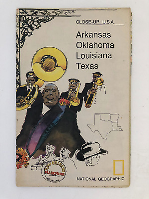
$5.49 Shipping Location: Georgetown, United States Template By Froo! National Geographic Map- 1974 Close-Up USA Oklahoma Texas Louisiana Arkansas National Geographic Map- 1974 Close-Up USA Oklahoma Texas ... moreLouisiana Arkansas Vintage 1974 two sided map Close-Up USA. Map shows Oklahoma, Louisiana, Arkansas, and Texas. The opposite side includes lots of historical information on the area by National Geographic Society. The map measures approx 35" x 23" in size. Never Unfolded. Shipping: All orders are carefully packaged. With a(Handle With Care Sticker) on the packaging. All orders ship the same or next business day. We ship orders Monday to Saturday. Orders placed before 2 pm(CST) on Fridays will ship on Saturday. We ship all orders via the United States Postal Service: First Class. Media Mail, Parcel Post, or Priority Mail, all include tracking numbers. Multi-Item Orders: We do combine shipping costs on multi-item orders. In order to receive the best shipping cost possible for your specific order please place your order. But before paying, request an invoice from us with combined shipping. We will return to you an adjusted invoice with the best shipping price for your order. Return Policy: Refunds given as money back or exchange(buyer’s choice) The buyer must pay return shipping. Please contact me within 14 days after receiving the item. Privacy Policy: Our company will never share your personal information in any way with an outside company. Our company will not send you unsolicited advertisements. Most reasonable offers are accepted. PayPal only. Please. Payment is expected within 2 days of auction end; immediate payment if you use Buy It Now. I will try and answer any questions. I am not an expert on anything I sell. And do my best to describe each item accurately. I buy many different items for the purpose of reselling them here on ebay. Any descriptions I give indicating the condition of item(s) such as: vintage. Antique, excellent, very good, good, and poor, or levels of functioning are purely subjective to what I observe, test and think of the item.
Buy It Now
$9.41 Shipping Condition: Very Good Location: LEAMINGTON SPA, United Kingdom The National Geographic Society, Washington D.C. However, we are not experts.
Buy It Now
$8.30 Shipping Location: Celina, United States See pictures, in good condition
Buy It Now
$8.30 Shipping Location: Celina, United States See pictures, in good condition
|
|
|
In
|
Rare Antique Historical Vintage Mint 1884 Map Indian Territorys Tribes Nations
Rare Vintage Large 1884 Map of Indian Territory Up for sale is a truly very nice Gram’s Atlas 1884 map of The Old West’s Indian Territory which is now modern day state of Oklahoma. The map was engraved based on data collected in 1880. George Gram is a noted engraver and map publisher. This is a very nice. Vintage rare map that is large and would look great framed. The map measures 13 ½ inches x 10 ½ inches. The map clearly indicates where the various Indian tribes lived at that time and include the Choctaw Nation. Kiowas, Comanches and Apaches, Cheyennes& Arrapahos, Creek Country, Choctaw Nation, Chickasaw Nation. Cherokees, Osages, Pawnees, Potawatomies, Cheyennes and the as well as The Public Lands just north of the Indian nation. The entire Indian Territory has a very attractive reddish border frame drawn around it. A great ... morelooking map! The map is in excellent condition and there are no folds or tears of any kind. This is a map that is 133 years old Will carefully ship in clear plastic cover and temporary corrugated backing to insure safe deliver. Thanks for looking!
|
|
|
1887 UNITED STATES MAP DIVISION OF STANDARD TIME NATIONS FLAGS 1887 CRAM
FREE SHIPPING* WE SELL THE ORIGINAL ITEMS NOT COPIES OR REPRODUCTIONS* REVIEW THE PICTURES- THESE MAPS ARE OVER 125 YEARS OLD WILL HAVE SOME PROBLEMS. FOXING DISCOLORATION AND TEARS ALONG THE EDGES. MOST OF THE MAPS WILL LOOK GOOD WITH PROPER MATTING ETC A SAMPLE PICTURE SHOWING A MAP MATTED WITH BLACK AND WHITE MATS IS INCLUDED IN THE LAST PICTURE THIS PICTURE IS NOT INCLUDED IN THE AUCTION OF THIS ITEM 1887 UNITED STATES MAP DIVISION OF STANDARD TIME NATIONS FLAGS 1887 CRAM M 02- UNITED STATES MAP SHOWING THE DIVISION OF STANDARD TIME 1887 CRAM. ON THE REVERSE SIDE IS FLAGS OF ALL NATONS NOTE THE FOXING THERE ARE SMALL TEARS IN THE BORDERS SOLD AS PICTURED- SIZE IS ABOUT 13.5 X 11.5 M 02 Powered by The free listing tool. List your items fast and easy and manage your active items.
|
|
|
c1895 MAP OF INDIAN NATIONS / UNITED STATES * Full Color Lithograph * Nice Color
Auction Wizard 2000 Listing Template- AW2KLOT#6613 Please note that Customs delays for international shipping have been SIGNIFICANT lately- days or even weeks longer than they should be! Please take this into consideration Our goal is 5 star service! If you feel we have not lived up to a 5 star rating. Please contact us as we only want 100% satisfied customers and NO misunderstandings! Description below pictures* c1895 MAP OF INDIAN NATIONS/ UNITED STATES* Full Color Lithograph* Nice Color* $46.20 An Original Vintage Antique Map: Not a Reproduction! See Our Ebay Store for other Antique Maps! Free US Shipping on Purchases of $100 value or more of Maps and Prints Description: This is an authentic antique map approximatley 117 years old! No publishing information. Possibly George F. Cram& Co. Circa 1895. Full color lithographic engraving. ... moreMap of Territorial Growth of the United States on reverse. The map is not mounted. Matted or framed and is being sold as a single sheet as shown in the first picture. Size: Map measures approximately 11 1/2 by 14 1/2 inches(29.2 x 36.8 cm) as seen in the pictures. Condition: This map is in good to very good condition. Some light soiling evident along margins. Light foxing as seen in the pics. It is basically as seen in the pics. Will frame up nicely. See pictures for more on condition. The pictures shown are of the actual print being sold. Shipping: Please use the calculator under the"Shipping and payments" tab above to determine shipping for your location. All packages are sent with Delivery confirmation where possible. We always combine shipping. So on multiple items please wait until we send you an invoice with the correct shipping applied. Maps and Prints will be shipped either flat or rolled depending on the items being shipped. We use only sturdy shipping materials to make sure the package arrives at its destination in undamaged condition. Insurance is on US! Please ask if you have any questions about shipping. Payment Details: We accept most major credit ca
|
|
|
ANTIQUE WALL MAP INDIAN NATIONS REPRESENTED 1861 TYRON ILLUSTRATED
AT AUCTION: ANTIQUE WALL MAP PRESENT CONTINENTAL US. EXCEPT ALASKA IN 1861 REPRESENTS TIME PERIOD FROM 1830-1861 TYRON ILLUSTRATED AMERICAN HISTORY MAPS WEBER COSTELLO CO. A.E.WALLMEYER ROLLA M. TYRON(PROFESSOR OF TEACHING HISTORY IN UNIVERSITY OF CHICAGO) THIS MAP REPRESENTS A LOT OF THE INDIAN NATIONS IT EVEN HAS ONE LISTED IN INDIAN TERRITORY HAS UNORGANIZED. OREGON TRAIL. PONY EXPRESS, SANTA FE TRAIL, BOUNDARY OF CONFEDERATE STATES, ETC THE COLOR IS STILL VERY VIVID FOR THE AGE OF THE PIECE UNFORTUNATELY. IT WAS AN ESTATE PIECE STORED IN A GARAGE AND IT DOES HAVE MILDEW. RAGGED EDGES. AS EXPECTED, I COULD ONLY SEE TWO SKID MARKS(PAPER THERE) IT MEASURES A VERY LARGE 47 1/2" X 36" ALL PAYMENTS ARE TO BE PAID 48 HOURS OF END OF AUCTION
|
|
|
Antique Color Map United States Time Zones or Flags of Nations Illus. 1886
This auction is for a two sided single page map and illustration. Single page maps are 10.5 x 13.5 inches. Please note. These are pages from an antique atlas so only one side can be framed for display. This map is from a"Cram's Unrivaled Family Atlas World Indexed 1883 revised for 1886" The photo of the title page of the atlas is for authentication purposes only and is not included in the auction. Thanks for looking and please be sure to visit my other auctions for more antique and vintage maps. Ads, magazines, post cards, books, and more. Powered by
|
|
|
INDIAN NATIONS MAP 1883 IN COLOR EPHEMERA SEE OTHERS Scarce Paper
EPHEMERA COLLECTIBLE MAP INDIAN NATIONS US IN COLOR-C)1883 NEW YORK PHILLIPS HUNT ENGRAVERS Measures 13 X 10 3/4 Overall very good condition. Light crease down middle that will iron out, light glue residue on back as this was a tipped in plate map in a book. small crease tear There is room for edge trimming. Great piece when framed! Will be packed very well with hard cardboard and plastic sheeting to prevent bending during shipment.
|
|
|
1896 - Map of The Indian Nations in the United States - Original Color Engraving
1896- Map of The Indian Nations in the United States- Original Color Engraving This listing is for an original antique color engraving done by I. S. Clare. This antique map dates from 1896. This particular map is a map of the Locations of The Indian Nations in the United States at the time of it's first settlement. This is a large size atlas map and measures 11 1/2" x 13 1/2" This map was professionally removed and has not been trimmed. Although we consider the condition of the map to be good it is still 120 years old so please take a close look at the pictures to be the final judge of condition. This map is free from any foxing. The color is more vibrant then shown in the picture and it displays very nice. These maps look amazing professionally framed and matted. Ideal for any room of the home. You will get exactly what is ... moreshow in the pictures. All of our maps and prints are shipped using strong cardboard mailing tubes. We only use acid free materials. This insures your map or print will arrive in the condition you see in the pictures. We do not ship in envelopes so our shipping is a bit more expensive than standard letter mail rates. All of our products are GUARANTEED original antiques- We do not deal in modern reproductions- SAVE ON COMBINED SHIPPING EACH ADDITIONAL MAP OR PRINT SHIPS FREE AFTER YOU PAY THE SHIPPING ON THE FIRST ITEM(Please wait to pay and request your total so we can update the invoice with the new shipping charge) All items will be sent AIRMAIL& insured through Canada Post- 1?RcmdId ViewItemDescV4,RlogId p4%60bo7%60jtb9%3Feog4d72f%2B%3E%3B1%3F-144f05901fc-0x120-
|
|
|
1896 Aboriginal America Map (The Indian Nations in the New World)
Listed is an 1896 Map of Aboriginal America. The Indian Nations in The New World. From 1896 Historical Atlas of the World. Shows the Distribution and Territorial Limits of the Indian Nations. Size app. 9" x 11" Great Color and Excellent condition. Photo does not do it justice. Would Frame Nicely. Does have History of the Map on back side. Great Collectible. Original from Atlas. Not a copy.
|
|
|
pre 1860's map of North America many indian nations noted
About 9 x 11 inches. No date given, very likely from a school Atlas. This is likely produced prior to the Civil War due to the large area attributed to Russian America, and a lack of surveyed coastlines in the far North. There are no boundary lines for state or territories. Cities and areas are indicated. Many Indian Tribes are generally located. One of the Western U.S. lakes is not completely surveyed. A very interesting item, too bad its only 9x11 inches. A Clear strike in printing this item allowing the detail to be seen clearly under magnification. Powered by
|
|
|
The Indian Nations of the United States 1893 original antique lithograph map
The Indian Nations of the United States 1893 original antique lithograph map DESCRIPTION Fine original antique lithographed color map. Printed in the late-19th century. DETAILS Printed: 1893- 122+ Year Old) Publisher: H. C. Hudgins and Co. New York Printed on quality heavy period paper. Map on reverse. Still retains its inherent structural flexibility and soundness. Sheet measures- 13 by 9 1/2 inches CONDITION Excellent condition. Remaining clean, a nice impression. Nice rich impression and well-preserved given the age. Please inspect photos closely. Any small or minor age flaws to the printed surface area should be visible within picture provided. We grade very conservatively and always seek to disclose any noteworthy flaws. We do our best to show& describe this item so you are happy when it arrives. NOT a Copy. Guaranteed to be Authentic! ... moreALL OFFERED PRINTS ARE AUTHENTIC ORIGINALS All the Prints that are offered are Original Prints and are Guaranteed to be Original Pieces. Never photocopies or reprints. All Prints are carefully selected and are ready for framing. All of our items are original antique pieces and it is important to keep in mind that many of them have been around for 100 years or more. Individual pieces may have seen many owners and been handled many times over the course of their existence and as a result each piece has developed a history of it's own. Short edge splits. Foxing, discoloration, etc. are all things to expect on items of this type. They rarely distract from the piece and often add to the overall character of the item. Keep in mind when you receive your item that you are not handling a modern copy, you are holding a piece of history, an item that has been around for a very long time and will, with proper care, be around for a long time to come. We try to note any significant flaws in the description, but less noticeable or common characteristics may not be mentioned. Each of these Prints offer a little flashback into the past and makes a great gift for the serious collector o
|
|
|
MAP OF ABORIGINAL AMERICA INDIAN NATIONS very old Map In Color Early 1800s
MAP OF ABORIGINAL AMERICA INDIAN NATIONS Very old Map In Color Early 1800s Light yellowing of the paper due to age. I did a little research and as far as I can see they date around 1882-1885. Overall very good condition.No rips small seam tear 1/4 inch on fold,slight fold down the middle, that will iron out, The map looks to have been a tipped in plate map and shows some glue residue on the back of the map. Has some browning spot on top of the seam front. Ready for framing. Measures-13 x 10 1/2
|
|
|
Large Old Folding Map Of Indian Nations West Of The Mississippi
Map is titled"A Topogra[phical] Sketch of the Missouri and U[pper] Missisippi[sic] Exhibiting the various Nations and Tribes of Indians who inhabit the Country. Copied from the Original Spanish MS. Map. This is a vintage reproduction of a manuscript map of the western United States and Canada. Appears to be photocopied from the original, not printed on a computer. The paper is waxy like a blueprint and is very brittle. As you can see, it has seen better days and has lots of tears, missing chunks, stains, folds, discoloration, etc. Measures about 16 1/2" x 18" at its widest(but has very uneven borders) Not an original, but not a modern repro either. A very interesting map for the person who has everything! Many, many Native American tribes listed! Due to the fragile nature of this item, it is being sold AS IS. Thanks for looking!
|
|
|
19TH CENTURY MAP SHOWING THE ORIGINAL 13 COLONIES AS OF 1776 INDIAN NATIONS 1884
UP FOR AUCTION. WE OFFER MAP OF THE ORIGINAL THIRTEEN COLONIES 1776[ 1884] A fine early vintage and genuine. Handsome and detailed map with a key printed in the blank area under the title.hand colored. And shows the states as they appeared in 1776. North and South Carolina and Georgia extending over to the Mississippi River. and Pennsylvania taking up the are north of the Ohio River. Virginia is the largest with its borders extending up into the Northwest Territory. The locations of the known Indian nations and tribes. The key gives the populations as of 1776, important battles of the Revolution, the settlement of the colonies, etc. This is a great map. No defects, measures about 12 x 15" overall. Never folded. Beautiful! NOTE: We will gladly combine your winning items into one shipment to save you postage costs. NOTE: If there is advertising ... morebelow and a web link. This is NOT US. And we do not endorse any item that is being offered in those links. We offer only genuine items. No worthless copies or reprints or reproductions. However, the movie thumb nail is indeed ours, showing other items and if any current bidding] A FRIENDLY NOTE ON SHIPPING Please note that I ship items as quickly as I can. We have a packing room all set up for me. I am a bit disabled from arthritis. some days are good, some days are not so good. There are times I cannot manage to pack up the winning orders, so there may be a day or two delay. Just to inform is all, please do not use this against me on the Ebay"star" system. Many thanks, and, Many thanks for the bidding. OVERSEAS SHIPPING INFORMATION We do not ship to countries that have a high rate of postal loss including Greece Italy Spain Ukraine Portugal USSR Mexico. China, and that includes all African countries. All the Middle East with the exception of Isarel. Without a $45 shipping charge for registered, signed, insurance. There are no exceptions. Sorry this has to be inforced, we no longer can handle the losses. Powered by The free listing tool. List your items fa
|
|
|
ORIGINAL 1893 MAP of INDIAN NATIONS IN THE UNITED STATES IN 1893 1893/021715
OFFERED FOR SALE IS AN 1893( not a reproduction) MAP of INDIAN NATIONS IN THE UNITED STATES. THIS PIECE WAS REMOVED FROM AN ANTIQUE 1893 ATLAS AND IS IN GOOD CONDITION WITH SOME MINOR BROWNING. SPOTTING& EDGE WEAR FROM IT'S 120+ YEARS OF AGING. IT IS UNDATED& MAY HAVE PRINTING ON IT'S REVERSE SIDE AS IT WAS REMOVED FROM AN ANTIQUE ATLAS BOOK. THE PAGE IS APPROX. 11" x 14" AND READY FOR FRAMING& DISPLAY. I HAVE MANY OTHER ANTIQUE WORLD, COUNTRY, STATE, CITY& TOWN MAPS FOR SALE AND I ALWAYS COMBINE SHIPPING FOR MULTIPLE PURCHASES. THANKS FOR LOOKING.
|
|
 |