-
Christian Collectibles
-
Christian Sheet Music
-
Vatican Stamps
-
Vatican Coins & Paper Money
-
Antiques
-
Antiquities
-
Architectural & Garden
-
Decorative Arts
-
Ethnographic
-
Furniture
-
Maps, Atlases & Globes
-
United States (Pre-1900)
-
AK, HI
-
AL, FL, GA, MS, NC, SC
-
AR, IA, KS, LA, MO, NE
-
AZ, CA, CO, NM, NV, UT
-
CT, MA, ME, NH, RI, VT
-
DC, DE, MD, NJ, NY, PA
-
ID, OR, WA
-
IL, IN, MI, OH, WI
-
MN, MT, ND, SD, WY
-
OK, TX
-
VA, WV, KY, TN
-
Entire US
-
United States (1900-Now)
-
United States (Date Unknown)
-
Africa
-
Asia
-
Australasia/ Oceania
-
Canada
-
Central America/ Caribbean
-
Europe
-
India
-
Ireland
-
Mexico
-
Middle East
-
North America
-
South America
-
United Kingdom
-
Maps on CD
-
World Maps
-
Globes
-
Mixed Lots
-
Reproductions
-
Price Guides & Publications
-
Other
|
In
Order by: Available to: This site contains affiliate links for which I may be compensated
|
Buy It Now
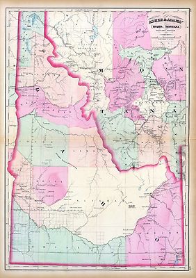
Free Shipping Location: Carefree, United States ORIGINAL ANTIQUE 1897 COLOR MAP OF IDAHO, WYOMING AND PART OF MONTANA. MAP HAS SCALES BELOW TITLE.

Buy It Now
$6.00 Shipping Location: Corunna, United States 1865 JOHNSON'S NEBRASKA. DAKOTA, IDAHO AND MONTANA Map Hand Colored Engraving Click Images to Enlarge An Original Vintage Antique Map: Not a Reproduction! ... moreSee Our Ebay Store for other Antique Items! Free US Shipping on Purchases of $100 value or more! Details Full Title: JOHNSON'S NEBRASKA. DAKOTA, IDAHO AND MONTANA Year: 1865 Publisher/Printer: Johnson and Ward. Engraving style: Hand colored engraving. Condition Grade: Collectible. Very Good condition Authentication: Appraisal Valuation Sheet available Appraised Value: $225.00 Approximate Size(inches) 26 1/4" x 18 1/4" Approximate Size(Cm) 66.6 x 46.4 Description This is an authentic antique map approximatley 148 years old! Circa 1865. Hand Colored steel engraving. Text on reverse. Folding doublepage map with very light wear and splitting at folds. The map is not mounted. Matted or framed and is being sold as a single sheet as shown in the first picture. This map is in Very good condition. Map shows some ocassional darkening at edges but still has strong presence. It is basically as seen in the pics. The pictures shown are of the actual map being sold. Keywords: Colored Engraved. Nebraska, Montana, Wyoming, Idaho, Dakota, Hand Colored, 1865, Color Engraving, Atlas Map CUSTOMER SERVICE& PRICING Our pricing directly reflects the time and careful consideration invested in acquiring and researching the finest quality products for you. The discriminating consumer. We recognize that all of our customers have their own specific needs and wants and we strive to meet these needs whether you are an Historical Institution, University, Library, Society, Archivist, Curator, Decorator, Designer, or Collector. We have structured our business to accommodate these requirements. We sell to a select group of customers from beginning collectors to advanced, seasoned collectors and everyone in between. Our many years of positive feedback from the thousands of loyal customers most often reflects the Quality of our items, Fine packaging, and Great Customer Servic
Buy It Now
Free Shipping Location: Sayville, United States Original 1891 Map of Montana. Wyoming& Idaho by Hunt& Eaton. Shows counties, major cities, reservations and the railroad lines throughout the ... morestates. On the rear are tables showing the population by county taken from the 1890 census. Measures approximately 13.37" by 11" This is a colorful and rare vintage lithograph that will look great matted and framed. See photo's. Free Shipping to anywhere in the US. Your order will always ship within ONE BUSINESS DAY. Well packaged in a sturdy waterproof mailer and sent with a delivery confirmatio n. I ship worldwide. Froo www.froo.com | Froo Cross Sell. Free Cross Sell, Cross promote, eBay Marketing, eBay listing Apps, eBay Apps, eBay Application.
Buy It Now
Free Shipping Location: Schertz, United States This is an authentic antique map of Montana, Wyoming, and Idaho from 1887. The double-page measures 15x23 and features hand-tinted highlights. The map ... moreis over 130 years old and was published by M. Bradley and S.A. Mitchell. Free shipping is available within the USA, while shipping for international orders is calculated at checkout. The book cover in the photo is only for reference purposes. This map is a great addition to any collection of antique maps or for anyone interested in the history of the American West.
Buy It Now
$6.95 Shipping Location: Dover, United States Issued c.1870, Philadelphia by S.A. Mitchell. Map of Oregon, Washington, Idaho, and Part of Montana. Late 19th century engraved map, with original hand ... morecolor. Gold and silver mines are noted on the map.
Buy It Now
Free Shipping Location: Schertz, United States This antique map from 1887 showcases Idaho, Montana, and Wyoming territories. It features hand-tinted highlights and shows Indian reservations. The double-page ... moresize of the map is 15x24. The map is an original and over 130 years old, making it a rare find for collectors. The publisher of the map is M. Bradley/S.A. Mitchell. The book cover is only for reference purposes. Free shipping is available within the USA, and international shipping is calculated based on location.
Free Shipping Location: Schertz, United States This antique map of The Wyoming, Montana & Idaho Territories is a piece of original history that is over 140 years old. The page measures 14x17 inches ... moreand features hand-tinted highlights. It was created by cartographer O. W. Gray and published by Milton R. Brown. The map is an authentic piece from the 1875 National Atlas and is in good condition. The title page and book cover shown are for reference purposes only. Free shipping is available within the USA, and shipping costs will be calculated for worldwide orders.
Buy It Now
$10.20 Shipping Location: Tonawanda, United States Includes Counties, County Seats, Cities; many Small Towns and Villages; Ports, Military Airfields and Forts; Rivers, Streams, Lakes, Mountains, and other ... moretopographical features are located on this map.
Buy It Now
Free Shipping Location: Florence, United States It's full of cool stuff! Thick paper.
Buy It Now
$6.95 Shipping Location: Dover, United States Tunison's Idaho and Western Montana. Issued c. 1892-6, Chicago by Tunison. Late 19th century lithographed map with original hand color. Map is set within ... moredecorative border, as is the title.
Buy It Now
$6.90 Shipping Location: Newark, United States Good condition. Creases lower left corner photo 8. Map is folded.
Buy It Now
$4.55 Shipping Location: Oakland, United States 12x10 inch This antique map from 1885 showcases the beautiful states of Oregon, Montana, Wyoming, Idaho, and Washington. With vibrant colors and intricate ... moredetails, this piece is a must-have for any collector of North American maps. The year 1885 marks an important time in American history, and this map is a valuable piece of that era.This map measures 12x10 inches and is perfect for display in any home, office, or museum. The cities and states depicted on the map are of historical significance and provide a glimpse into the past. Whether you're a map enthusiast or simply looking for a unique piece of history to add to your collection, this antique map is sure to impress.
Buy It Now
Free Shipping Location: Anaheim, United States Typically that map at hand, the one being looked at, is in the center box. Scale: 1:100,000 (100K). feature within the bounds of the map, which frequently ... moreis a community, town, or city. The map covers a specific amount of area.
Buy It Now
$6.95 Shipping Location: Dover, United States Uncommon late 19th century lithographed map, with original hand color. This late Mitchell map was issued by Bradley for a short period before disappearing ... morefrom publication. Issued c. 1886-8, Philadelphia by Bradley, successor to S.A. Mitchell.
Buy It Now
$6.95 Shipping Location: Dover, United States Issued 1887, Philadelphia by Bradley, successor to S.A. Mitchell. This late Mitchell map was issued by Bradley for a short period before disappearing ... morefrom publication. Fine oversize late 19th century lithographed map, with original hand color.
Buy It Now
$6.95 Shipping Location: Dover, United States Map of Oregon, Washington, Idaho, and Part of Montana. Gold mines are noted, as are emigrant wagon trails. There are many variant issues of this map, ... morewith differing borders and interior details. Issued c.1840, Philadelphia by S. Augustus Mitchell.
Buy It Now
$4.88 Shipping Location: Las Cruces, United States Publisher: U.S. Geological Survey.
Buy It Now
Free Shipping Location: Hailey, United States This is a Salmon Idaho-Montana 1996 Topographical Map. We will do our best to provide you the best possible service.
Buy It Now
$4.99 Shipping Location: Fairview, United States Condition: The map is in Very Good condition with light tonal aging and text on reverse. The pics are of the actual map. An Authentic Antique Map: Not ... morea Modern Reproduction!
Buy It Now
Free Shipping Location: Springfield, United States Unique Album & Atlas of the World 1894. Not a Facsimile - This is a single page culled from an 1894 Unique Atlas, Page does not have date, Books of this ... moreage rarely had color print which was very expensive during the 19th century.
Buy It Now
$6.00 Shipping Location: Columbus, United States This antique map is in Very Good condition, with nice bright hand coloring. The map shows light toning to the edges. The map shows Boise City, Virginia ... moreCity, Helena, and more. The map is held in a clear, plastic, protective slip.
Buy It Now
Free Shipping Location: Anaheim, United States Typically that map at hand, the one being looked at, is in the center box. Scale: 1:100,000 (100K). feature within the bounds of the map, which frequently ... moreis a community, town, or city. The map covers a specific amount of area.
Buy It Now
Free Shipping Location: Anaheim, United States Typically that map at hand, the one being looked at, is in the center box. Covers about 1,568 to 2,240 square miles depending up the longitude & latitude ... morelocation. Bio-predation & Oxidation (aging, age discoloration mainly on the outside and exposed edges and folds).
3d 10h 2m 22s 0 bids
$65.00 Now
$20.30 Shipping Location: Celina, United States 29” x 21” Plastic Raised Relief 3D Topographical Map, Very Good/Excellent Condition, Few Minor Cracks, 1956 Photography Field, Constructed & Molded in ... more1960.
Buy It Now
$4.88 Shipping Location: Las Cruces, United States Publisher: U.S. Geological Survey. Scale: 1:62,500.
Buy It Now
$3.25 Shipping Location: Missoula, United States This Topographical, Geologic map is for Ashton, Montana, Idaho, Wyoming. The date is 1955-67. The map was published by the Army Corp of Engineers. size ... moreis 26" across and 22" down.
Buy It Now
$6.00 Shipping Location: Rochester, United States These are not heavy creases, as in a folded map, and should flatten out easily. There is also "edge wear" on the right side of the map (see photograph). ... moreThe shadows in the corners of the map are from the clear plastic containers (red lids) used to hold the map in place.
Buy It Now
$4.99 Shipping Location: Fairview, United States New Indexed Family Atlas, published by Gaylord Watson, New York, 1882, a copy of the title page is included for authenticity. It is from Watson's. An ... moreAuthentic Antique Map: Not a Modern Reproduction!
Buy It Now
$6.95 Shipping Location: Dover, United States Issued 1879 Gotha by Justus Perthes for Stieler. Very detailed 19th century engraved map with original outline hand color. Original center fold as issued.
Buy It Now
$6.95 Shipping Location: Dover, United States Issued 1890, NY by Scribner & Black. Montana - Idaho - Wyoming. Scarce oversized folio sheet late 19th century color lithographed map.
Buy It Now
$6.95 Shipping Location: Dover, United States Map has a different map of Montana, Idaho, and Wyoming on the back. You will receive one sheet printed on both sides. Nice 19th century lithographed map ... morewith original hand color. Based on the Colton 1855 map.
Buy It Now
Free Shipping Location: Hemet, United States This contemporary map is an excellent reproduction that captures the beauty and diversity of the Western US. Goes especially well for any cabin decor ... morein any mountainous region.
Buy It Now
$4.88 Shipping Location: Las Cruces, United States Publisher: U.S. Geological Survey.
Buy It Now
Free Shipping Location: Hailey, United States This is a Borah Peak Idaho Montana 1993 Topographical Map 38"x25". We will do our best to provide you the best possible service.
Buy It Now
$4.88 Shipping Location: Las Cruces, United States Publisher: U.S. Geological Survey. Scale: 1:62,500.
Buy It Now
$4.88 Shipping Location: Las Cruces, United States Publisher: U.S. Geological Survey. Scale: 1:250,000.
Buy It Now
$4.88 Shipping Location: Las Cruces, United States Publisher: U.S. Geological Survey.
Buy It Now
$4.00 Shipping Location: Mobile, United States There may be creases and/or small tears and/or markings on the item.
Buy It Now
$6.95 Shipping Location: Dover, United States Issued 1894 Gotha by Justus Perthes for Stieler. Very detailed 19th century engraved map with original outline hand color. Original center fold as issued.
Buy It Now
$13.80 Shipping Location: MANCHESTER, United Kingdom Beautiful large antique map on quality paper Very Good condition and rescued from a disbound Atlas: BLACK'S GENERAL ATLAS OF THE WORLD 1897. THIS ... moreSUPERB VICTORIAN MAP IS AN ORIGINAL- OVER 115 YEARS OLD*FEATURES SUPERB DETAIL* Published by Adam& Charles Black. London. This single map measures approximately 17 1/2 inches by 12 inches(445mm x 305mm) Please message with any questions regarding this item. BEST OFFERS PLEASE FOR A QUICK SALE AT A FAIR PRICE If you like the item. But do not like the price, then make a realistic offer to us using the MAKE OFFER BUTTON. Powered by
Buy It Now
$6.90 Shipping Location: HORNCASTLE, United Kingdom
Buy It Now
$4.99 Shipping Location: Fairview, United States There is also a map on the reverse. The pics are of the actual map.
Buy It Now
Free Shipping Location: Anaheim, United States Old Paper Map. Map is folded. © 2006 (Original sale dates December 2005 to March 2007).
Buy It Now
$4.55 Shipping Location: Oakland, United States This antique map depicts the North-Western region of the United States, specifically Washington, Oregon, Idaho, Montana, and Wyoming. The intricate details ... moreand colors showcase the topography, cities, and landmarks during the late 19th century. It is a valuable addition to any collection of antique maps or for those interested in the history of the region. The map measures 11x13 inches and is an original piece from 1888.
Buy It Now
$4.55 Shipping Location: Oakland, United States This antique map from Rand McNally & Co. features the US states of Montana and Idaho. The map was published in 1904 and measures 7 inches by 6 inches. ... moreIt is a great addition for antique map collectors and those interested in the history of these two US states. The map is in good overall condition and would make a wonderful display piece for any home or office.
Buy It Now
Free Shipping Location: Anaheim, United States Typically that map at hand, the one being looked at, is in the center box. Scale: 1:100,000 (100K). feature within the bounds of the map, which frequently ... moreis a community, town, or city. The map covers a specific amount of area.
Buy It Now
$5.00 Shipping Location: Firestone, United States Geological Survey: NL 11-6 (1:250 000 Scale). Pencil marks are present at the top of the map and may be present elsewhere. This map was found folded in ... morehalf (height wise) and has a crease present in the center.
Buy It Now
$6.00 Shipping Location: Saint Johnsbury, United States
Buy It Now
$4.55 Shipping Location: Oakland, United States This antique map of Montana and Idaho, published by Rand McNally & Co. in 1899, is a stunning piece of history that will make a beautiful addition to ... moreany collection. Its intricate details and accuracy provide a unique glimpse into the geography and landscape of these two states at the turn of the 20th century.With its colorful and detailed design, this map is a true work of art. It depicts the topography, cities, towns, and railroads of Montana and Idaho, as well as other important landmarks and features. Whether you are a collector, historian, or simply appreciate the beauty of antique maps, this piece is sure to impress.
Buy It Now
Free Shipping Location: Anaheim, United States EasyFinder ® also known asEasy to Fold! Plastic Coated Paper (laminated). Idaho Falls inset map. Bio-predation & Oxidation (aging, age discoloration mainly ... moreon the outside panels). State Series. Map Publisher: RAND-McNALLY.
Buy It Now
$4.88 Shipping Location: Las Cruces, United States Publisher: U.S. Geological Survey. Map: MF-1354-A.
Buy It Now
$4.55 Shipping Location: Oakland, United States This antique map from Rand McNally & Co. features Montana and Idaho and was published in 1899. The map showcases various cities, regions, and landmarks ... moreof the two states. It is a great piece of history for collectors looking to add a unique item to their collection. The map measures 7x6 inches and is in good condition.
Buy It Now
Free Shipping Location: Anaheim, United States Bio-predation & Oxidation (aging, age discoloration mainly on the outside panels). Flat Sheet Chart that is Production Folded in Quarters. ID: map1083.
Buy It Now
Free Shipping Location: Anaheim, United States Typically that map at hand, the one being looked at, is in the center box. Scale: 1:100,000 (100K). feature within the bounds of the map, which frequently ... moreis a community, town, or city. The map covers a specific amount of area.
Buy It Now
$4.88 Shipping Location: Las Cruces, United States Publisher: U.S. Geological Survey. Scale: 1:62,500.
Buy It Now
$4.13 Shipping Location: Franklin, United States Engraved by E. F. Fisk. Montana, Idaho & Wyoming. Antique 1881 Map. By Hunt & Eaton, New York.
Buy It Now
Free Shipping Location: Monroeville, United States Date - 1887. Source - Peoples World Atlas.
Buy It Now
Free Shipping Location: Anaheim, United States Idaho and Montana. BUTTERROT, CLEARWATER, LOLO AND NEZPERCE NATIONAL FOREST. 1980 (1989 Limited Revision ). Bio-predation & Oxidation (aging, age discoloration ... moremainly on the outside panels). Dried out like it's been wet.
Buy It Now
$3.95 Shipping Location: Clarkston, United States Rare Map Collection This DVD is part of our Historic Map and Atlas Collection. We have dozens of Atlas maps on DVD and CD ranging from the 1500s to the ... more1900s covering many areas and topics. Please Check our Ebay Store for what's available. FOR MANY MORE EDUCATIONAL CD TITLES ON THIS AND MANY OTHER SUBJECTS PLEASE VISIT OUR EBAY STORE VERY LARGE HIGH RESOLUTION MAP COLLECTION ON DVD! please see full table of contents and sample illustrations below) This DVD Contains 101 Maps of Idaho Including 44 PANORAMIC MAPS of various Idaho Cities These are scans of the ORIGINAL maps by various Cartographers. on DVD System requirements PC or Mac compatible. Files are simple PDF files with a basic HTML interface(just like viewing a webpage) Works with ALL versions of Windows. Maps of Idaho 0041037 Idaho. Montana west Asher& Adams 1874, 0586049 Idaho. Hand colored. Relief shown by hachures. Shows counties. Indian reservations, townships, settlements, rivers, etc. Mitchell. Samuel Augustus 1880, 0806001 Road map Idaho. Mont. Wyo. Rand McNally and Company; Texas Company 1937, 2212244 Partie des Etats-Unis. Amer. Sep. 39. Hand col. lithographed map. Relief shown by hachures. Shows Indians tribes with populations. Lewis and Clarke's route, etc. Covers parts of Idaho, Montana and Wyoming. Vandermaelen. Philippe 1827, 2738014 32D. Part Of South-Eastern Idaho Part Of South-Eastern Idaho. Atlas Sheet No. 32(D) Issued June 30, 1879. Weyss, Lang& Herman Del. Expedition of 1877, Under the Command of 1st Lieut. Geo. M. Wheeler, Corps of Engineers, U.S. Army. U.S. Geographical Surveys West Of The 100th Meridian. 1879, 2738015 32D. Land Classification Map Of Part Of South-Eastern Idaho. showing land classification. In full color with area and percentage of classifications noted. Wheeler. G.M. 1879, 2738020 41A. Parts Of Southern Idaho& Northern Utah Wheeler. G.M 1880, 2773005 Map Of The Road From Missouri To Oregon. Section V. Fremont. J.C. Preuss, Charles 1846, 2773006 Map Of The Road From Missouri To Oregon. Section VI.
Buy It Now
$8.78 Shipping Location: United Kingdom "Stielers Atlas of Modern Geography" by Adolf Stieler. Center fold as published. Antque Lithograph Map Published 1909 by Justus Perthes, Gotha for.
|
|
|
In
|
1905 Antique Map Idaho Montana
1905 Montana. Idaho Please note: This is a two sided map with an image on either side. You will not receive two separate maps. They are on heavy paper and the image on the backside cannot be seen through to the other side. Item: This is a rare. 107 year old, authentic 1905 map. It is NOT a reproduction. Book Title: Hammond's Modern Atlas of the World" Publisher: C. S. Hammond& Company 1905 Size: Approx. 9 1/2" x 12" There is a 1 inch border on two sides and a 1/2 inch border on the other two sides which my scanner cuts off. COA: You will receive a copy of the title page and copyright page from the original book to show authenticity. Condition: These maps seem to be in very good condition. Please note that I am not an expert in judging the condition of antique maps. See scan for condition and if you have any questions. ... morePlease let me know. Shipping: I am always happy to combine shipping when I can. Please just wait for an invoice if you purchase more than one item. I always do my best to save you as much as I can on shipping costs. Refund policy: I offer a lifetime. No questions asked refund. If you are unhappy with your purchase, simply return it for a full refund. It's that simple. For my international customers: You will be responsible for any import taxes. Duties, or custom charges that may by required by your country. Those costs are not included in the price of this item.
|
|
|
Antique Idaho or Montana Map 1899 Color
This map is in very good condition. Map measures 11 x 14 inches and is suitable for framing. You are bidding on a map from a 1899 Rand McNally Atlas Of The World. Please keep in mind. If it is a two sided page, only one map can be displayed at a time. This map will be shipped wrapped in plastic reinforced with cardboard for support Thanks for looking and please be sure to visit my other auctions for more antique and vintage maps. Ads, magazines, post cards, books, and more. Powered by
|
|
|
1870 S Augustus Mitchell County Map of Oregon, Washington, Idaho & Montana
Helpful Links: Company Details- About ME View seller's other items Cartographer's Profile Ask Seller a q uestion Return Policy We have over 2.000 items for sale on our Ebay stores site. Please click here to enter the stores and use the search cell to search specifically for maps. Prints, Atlases on the Classical Images Ebay Store. Click Here County Map of Oregon. Washington, Idaho and Part of Montana.1870 by S. Augustus Mitchell click image to enlarge This beautifully hand coloured original antique map was published by Samuel Augustus Mitchell in the 1870 edition of his large New General Atlas- dated at the foot of the map. These county. State, city& country maps are some of the most ornate and beautifully coloured maps published in the US in the 19th century. For over 50 years, Mitchell his son's and their successors were ... morethe most prominent cartographical publishers of maps and atlases in the United States. Samuel Augustus Mitchell was born in Bristol. Connecticut on March 20, 1792. His father emigrated from Scotland in 1773. While little is know about his early schooling, it is know that Mitchell found the quality of early geography text books to be lacking, and determined that he would write and publish better works. This decision led him to relocate to Philadelphia in 1829 or 1830, which was then the center of commercial publishing in America. Mitchells first cartographic work was the re-issue of Anthony Finleys New American Atlas in 1831. A work first issued by Finley in 1826, in response to Henry Schenk Tanners monumental work of the same title, issued in serial format from 1818 to 1822 and as a complete work from 1823 onward. While the map content in Mitchells edition of the New American Atlas are same as Finleys edition, each map has been significantly improved and revised, primarily with the addition of new owns and roads. This is especially true in the South and West. Finley had originally collaborated with D.H. Vance and J.H. Young in the preparation of the maps. Vances name is removed
|
|
|
Antique Map of Idaho & Montana VG Condition Authentic 17 X 11.5 Map circa 1900
This is an antique map of Idaho and Montana. This is an original antique engraving. Circa 1900. This map was part of The 11 th Edition of the Encyclopedia Britannica. This genuine antique map page measures 11 ½ inches by 17 inches and is in very good condition. Please contact me for more information. And please see our other antique maps& prints. Check out my! We Ship Worldwide And Combine Orders. All Orders Ship Via USPS Buy with confidence. All orders are shipped promptly with a tracking number. eBay best practices policies are followed.
|
|
|
Antique Color Map Idaho or Montana 1899 Universal Atlas
This map is in very good condition. Maps measures 14 x 11 inches inches and is suitable for framing. You are bidding on a page from a 1899 Rand McNally Atlas. Please keep in mind. If it is a two sided page, only one map can be displayed at a time. This map will be shipped wrapped in plastic and secure. Thanks for looking and please be sure to visit my other auctions for more antique and vintage maps. Ads, magazines, post cards, books, and more. Powered by
|
|
|
1858 UNITED STATES WITH TERRITORIES PRE COLORADO IDAHO MONTANA ARIZONA
TITLE THE UNITED STATES DATE-1858 ISSUED AND OR DRAWN BY PUBLISHED IN CORNELL'S ATLAS AND DRAWN BY J WELLS THIS AUCTION IS FOR AN ORIGINAL HAND-COLORED MAP FROM 1858 OF THE UNITED STATES. MAP SHOWS AN EARLY CONFIGURATION OF THE U.S. WITH TERRITORIES OF NEBRASKA. NEW MEXICO, UTAH, OREGON AND WASHINGTON. INDIAN TERRITORY IS ALSO SHOWN AS WELL AS DACOTA TERRITORY. VERY FEW TOWNSHIPS WERE ESTABLISHED IN THE WEST BUT SHOWS SAN FRANCISCO, SOCORRO, FILLMORE CITY UTAH AND UMQUA CITY OREGON. MEASURES 10.5 X 17 INCHES GOOD CONDITION. BORDER AT RIGHT WAS PUBLISHED WITH CROPPED BORDER. MAP OF NEW ENGLAND ON REVERSE
|
|
|
ORIGINAL 1885 MAP of the TERRITORIES of WASHINGTON, IDAHO, MONTANA, WYOMING
OFFERED FOR SALE IS AN 1885( not a reproduction) MAP of the STATE of OREGON& the TERRITORIES of WASHINGTON. IDAHO, MONTANA& WYOMING. THIS PIECE WAS REMOVED FROM AN ANTIQUE 1885 ATLAS AND IS IN GOOD CONDITION WITH SOME MINOR BROWNING& EDGE WEAR FROM IT'S 129 YEARS OF AGING. IT MAY HAVE PRINTING ON IT'S REVERSE SIDE AS IT WAS REMOVED FROM AN ANTIQUE ATLAS BOOK. THIS MAP IS VERY DETAILED, DATED& HAS VIBRANT COLORS FOR IT'S AGE. IT IS APPROX. 10" x 12" AND READY FOR FRAMING& DISPLAY. I HAVE MANY OTHER ANTIQUE WORLD, COUNTRY, STATE, CITY& TOWN MAPS FOR SALE AND I ALWAYS COMBINE SHIPPING FOR MULTIPLE PURCHASES. THANKS FOR LOOKING. AVAILABLE
|
|
|
ORIGINAL 1884 MAP, TERRITORIES of IDAHO, MONTANA & WYOMING 82914
OFFERED FOR SALE IS AN 1884( not a reproduction) MAP of the TERRITORIES of IDAHO. MONTANA& WYOMING. THIS PIECE WAS REMOVED FROM AN ANTIQUE 1884 ATLAS AND IS IN GOOD CONDITION WITH SOME MINOR BROWNING& EDGE WEAR FROM IT'S 130 YEARS OF AGING. IT IS UNDATED& MAY HAVE PRINTING ON IT'S REVERSE SIDE AS IT WAS REMOVED FROM AN ANTIQUE ATLAS BOOK. IT IS APPROX. 14" x 12" AND READY FOR FRAMING& DISPLAY. I HAVE MANY OTHER ANTIQUE WORLD, COUNTRY, STATE, CITY& TOWN MAPS FOR SALE AND I ALWAYS COMBINE SHIPPING FOR MULTIPLE PURCHASES. THANKS FOR LOOKING. AVAILABLE
|
|
|
Antique 1899 Map Montana OR Idaho & Wyoming
Antique 1899 Map Montana OR Idaho& Wyoming This map is in very good condition and measures 10 3/4 x 13 5/8 inches. Map is from the New Peerless Atlas of the World published in 1899 by The Crowell& Kirkpatrick Co. of Springfield. Ohio. Each map is double-sided. So it will be up to the buyer to decide which side to display. Thanks for looking and please be sure to visit my other auctions for more great maps. Vintage ads, books, and other collectibles. Powered by SixBit's eCommerce Solution
|
|
|
ORIGINAL 1871 MAP of OREGON, WASHINGTON, IDAHO & MONTANA 1872/012315
OFFERED FOR SALE IS AN ORIGINAL 1871( not a reproduction) MAP of OREGON. WASHINGTON, IDAHO& MONTANA. THIS PIECE WAS REMOVED FROM AN ANTIQUE 1872 ATLAS AND IS IN GOOD CONDITION WITH SOME VERY MINOR BROWNING& EDGE WEAR FROM IT'S 140+ YEARS OF AGING. IT IS DATED 1871 IN SMALL PRINT AT THE BASE OF THE PAGE. THE PAGE IS APPROX. 12" x 15" AND READY FOR FRAMING& DISPLAY. I HAVE MANY OTHER ANTIQUE WORLD, COUNTRY, STATE, CITY& TOWN MAPS FOR SALE AND I ALWAYS COMBINE SHIPPING FOR MULTIPLE PURCHASES. THANKS FOR LOOKING.
|
|
|
ORIGINAL 1874 MAP, OREGON STATE & WASHINGTON, IDAHO & MONTANA TY. 1874/013015
OFFERED FOR SALE IS AN ORIGINAL 1874( not a reproduction) MAP of OREGON. WASHINGTON, IDAHO& MONTANA. THIS PIECE WAS REMOVED FROM AN ANTIQUE 1874 ATLAS AND IS IN GOOD CONDITION WITH SOME VERY MINOR BROWNING& EDGE WEAR FROM IT'S 140+ YEARS OF AGING. IT IS DATED 1874 IN SMALL PRINT AT THE BASE OF THE PAGE. THE PAGE IS APPROX. 11" x 15" AND READY FOR FRAMING& DISPLAY. I HAVE MANY OTHER ANTIQUE WORLD, COUNTRY, STATE, CITY& TOWN MAPS FOR SALE AND I ALWAYS COMBINE SHIPPING FOR MULTIPLE PURCHASES. THANKS FOR LOOKING.
|
|
|
1882 LARGE MAP UNITED STATES CALIFORNIA OREGON NEVADA MONTANA UTAH IDAHO WYOMING
THIS IS AN ORIGINAL MAP. NOT A RECENT COPY OR REPRODUCTION. Origin of the map: Adolf Stieler's Hand-Atlas uber alle Theile der Erde. Publ. by J. Perthes, Gotha(Germany)MODERN HAND COLORED Date of issue: 1882 Size: The sheet measures 18" x 15" 46.5 x 38 cm) S/H: The map will be shipped by Priority International Air Mail. The shipping charge is 8.5.00 USD( with the tracking number) Or 7.00 USD( without the tracking number) If you wish to save 1.50 USD on the tracking number. Please let me know before you send the payment. Then wait for my invoice. Attention! There is no additional shipping charge for multiple purchases!
|
|
|
ORIGINAL 1860 MAP of OREGON, WASHINGTON, IDAHO & MONTANA 1865/022715
OFFERED FOR SALE IS AN ORIGINAL 1860( not a reproduction) MAP of OREGON. WASHINGTON, IDAHO& MONTANA TERRITORY. THIS PIECE WAS REMOVED FROM AN ANTIQUE 1865 ATLAS AND IS IN GOOD CONDITION WITH SOME MINOR BROWNING, SPOTS& EDGE WEAR FROM IT'S 150+ YEARS OF AGING. THE MAP IS HAND COLORED WITH VIBRANT MULTI- COLORS. IT IS DATED 1860 IN SMALL PRINT AT THE BASE OF THE PAGE. THE PAGE IS APPROX. 12" x 15" AND READY FOR FRAMING& DISPLAY. I HAVE MANY OTHER ANTIQUE WORLD, COUNTRY, STATE, CITY& TOWN MAPS FOR SALE AND I ALWAYS COMBINE SHIPPING FOR MULTIPLE PURCHASES. THANKS FOR LOOKING.
|
|
 |