-
Christian Collectibles
-
Christian Sheet Music
-
Vatican Stamps
-
Vatican Coins & Paper Money
-
Antiques
-
Antiquities
-
Architectural & Garden
-
Decorative Arts
-
Ethnographic
-
Furniture
-
Maps, Atlases & Globes
-
United States (Pre-1900)
-
AK, HI
-
AL, FL, GA, MS, NC, SC
-
AR, IA, KS, LA, MO, NE
-
AZ, CA, CO, NM, NV, UT
-
CT, MA, ME, NH, RI, VT
-
DC, DE, MD, NJ, NY, PA
-
ID, OR, WA
-
IL, IN, MI, OH, WI
-
MN, MT, ND, SD, WY
-
OK, TX
-
VA, WV, KY, TN
-
Entire US
-
United States (1900-Now)
-
United States (Date Unknown)
-
Africa
-
Asia
-
Australasia/ Oceania
-
Canada
-
Central America/ Caribbean
-
Europe
-
India
-
Ireland
-
Mexico
-
Middle East
-
North America
-
South America
-
United Kingdom
-
Maps on CD
-
World Maps
-
Globes
-
Mixed Lots
-
Reproductions
-
Price Guides & Publications
-
Other
|
In
Order by: Available to: This site contains affiliate links for which I may be compensated
|
Buy It Now
Free Shipping Location: Schertz, United States This antique map/ chart from 1875 depicts the drill test borings of Holmes County, Ohio. Measuring approximately 14" x 17", this map features original ... morecoloring and was published by Henry Cring and J.A. Caldwell. It is an authentic piece of history, printed in 1875 and is a valuable addition to any collection. The map includes important information about the drill test borings in Holmes County, Ohio, making it a great resource for historians and researchers alike. Free shipping is available within the USA, with calculated shipping options for worldwide delivery. Add this rare and unique item to your collection today.
Buy It Now
Free Shipping Location: North Wales, United States 1875 FRANCIS MCNALLY ATLAS MAP-CHART OF EARTH'S HIGHLANDS & LOWLANDS ORIGINAL ANTIQUE ATLAS MAP PLEASE SEE PHOTOS AS PART OF THE DESCRIPTION CONDITION: ... moreMAP IS IN GOOD CONDITION. SIZE: APPROXIMATELY 9.5" X 12.5" SHIPPING: U.S. FIRST CLASS RATE - $6.00 - ANY ITEM WHICH SELLS FOR OVER $100 WILL REQUIRE INSURANCE WE COMBINE SHIPPING FOR MULTIPLE WINS. THANK YOU FOR YOUR INTEREST IN OUR AUCTIONS!.
Buy It Now
$6.00 Shipping Location: North Wales, United States 1875 ANTIQUE HARPER'S ATLAS MAP-COMMERCIAL CHART OF WORLD SHOWING TRADE ROUTES ORIGINAL ANTIQUE ATLAS MAP PLEASE SEE PHOTOS AS PART OF THE DESCRIPTION ... moreCONDITION: MAP IS IN GOOD CONDITION. FOXING PRESENT. SIZE: APPROXIMATELY 6" X 6.5" SHIPPING: U.S. FIRST CLASS RATE - $6.00 - ANY ITEM WHICH SELLS FOR OVER $100 WILL REQUIRE INSURANCE WE COMBINE SHIPPING FOR MULTIPLE WINS. THANK YOU FOR YOUR INTEREST IN OUR AUCTIONS!.
Buy It Now
$6.00 Shipping Location: North Wales, United States 1875 MCNALLY ATLAS MAP-CHART OF EARTH'S BASINS, OCEAN CURRENTS, & CO-TIDAL LINES ORIGINAL ANTIQUE ATLAS MAP PLEASE SEE PHOTOS AS PART OF THE DESCRIPTION ... moreCONDITION: MAP IS IN GOOD CONDITION. SIZE: APPROXIMATELY 9.5" X 12.5" SHIPPING: U.S. FIRST CLASS RATE - $6.00 - ANY ITEM WHICH SELLS FOR OVER $100 WILL REQUIRE INSURANCE WE COMBINE SHIPPING FOR MULTIPLE WINS. THANK YOU FOR YOUR INTEREST IN OUR AUCTIONS!.
Buy It Now
$5.00 Shipping Location: Los Angeles, United States He was born at Kirkhill nearPenicuik, south ofEdinburgh. He was the son of Andrew Johnston and Isabel Keith. His brother was Thomas Brumby Johnston. Alexander ... moreKeith Johnston (1804–1871). Johnston was the first to bring the study ofphysical geography into competent notice in England.
Buy It Now
$35.00 Shipping Location: Canada Fowey Harbour. conducted in 1856. British Admiralty, London, 1875. in Cornwall, southern England. and blank on the reverse. The chart is based on surveys. ... moreThe map was first printed by the. to the neat line.
Buy It Now
$3.75 Shipping Location: United States Printed on thick fine paper, no printing on reverse, with gorgeous delicate period handcoloring, this is period to the map, this is before color printing. ... moreThe map is very detailed, attractive and in nice condition.
Buy It Now
$6.95 Shipping Location: Dover, United States Issued 1875 Gotha by Justus Perthes for Stieler. Map by Stieler & Bruhns. Very detailed 19th century color lithographed celestial star chart.
Buy It Now
$31.37 Shipping Location: BOURNEMOUTH, United Kingdom PUBLISHED - AT THE ADMIRALTY, 9th JULY 1875, LONDON. BRITISH ADMIRALTY /SEA CHART/ NAUTICAL MAP. MAP SIZE- 655 mm x 845 mm. CONDITION- GOOD- STAINS, CREASES, ... moreTEARS AT THE EDGES, REPAIR ON VERSO - SEE PHOTOS.
Buy It Now
$13.80 Shipping Location: MANCHESTER, United Kingdom Daniel Lizars Sr. (1754-1812) was the son of a shoemaker, but he apprenticed with Andrew Bell, a printer and engraver. The map is printed on good quality ... morethick paper.
Buy It Now
$4.00 Shipping Location: United States The map is titled, in fine fancy antique lettering, Political Map of Illinois, Warner & Beers, with detailed Explanation chart at lower left hand side, ... moreand Wortherns Geological and Climate Map of Illinois, with handcolored Explanation chart at lower left hand side, corresponding to the map itself.
Buy It Now
$4.25 Shipping Location: United States This is the finest map of this area I've ever seen, the condition is amazing. The map is printed on thick paper, with no printing on reverse. The condition ... moreis just amazing, beautiful topflight condition.
Buy It Now
$21.59 Shipping Location: GULLANE, United Kingdom ADMIRALTY SEA CHART of. Admiralty Chart No. 721. Originally published by the British Admiralty in 1875. SEYCHELLES GROUP. This chart shows in great details ... moreof the SEYCHELLES GROUP. INDIAN OCEAN. This 197i edition.
Buy It Now
$3.95 Shipping Location: Clarkston, United States This DVD is part of our Historic Map and Atlas Collection. at Falmouth, 4th September 1765. Joseph Noyes, surveyr. Joseph Noyes, survayor. Falmouth, May ... more22nd, 1766. This DVD Contains. Bird's eye view of the City of Bangor, Penobscot County, Maine, 1875.
Buy It Now
$6.95 Shipping Location: Dover, United States Issued 1875 Gotha by Justus Perthes for Stieler. Map by Stieler & Bruhns. Very detailed 19th century color lithographed celestial star chart.

Buy It Now
$3.95 Shipping Location: Clarkston, United States Rare Map Collection This DVD is part of our Historic Map and Atlas Collection. We have dozens of Atlas maps on DVD and CD ranging from the 1500s to the ... more1900s covering many areas and topics. Please Check our Ebay Store for what's available. FOR MANY MORE EDUCATIONAL CD TITLES ON THIS AND MANY OTHER SUBJECTS PLEASE VISIT OUR EBAY STORE VERY LARGE HIGH RESOLUTION MAP COLLECTION ON DVD! please see full table of contents and sample illustrations below) This DVD Contains 139 Maps of Rhode Island Including 4 PANORAMIC MAPS of various Rhode Island Cities These are scans of the ORIGINAL maps by various Cartographers. on DVD System requirements PC or Mac compatible. Files are simple PDF files with a basic HTML interface(just like viewing a webpage) Works with ALL versions of Windows. Maps of Rhode Island 0028035 Arrowsmith. Aaron; Lewis, Samuel) 1812 Rhode Island. 0089012 Bradford. Thomas G. 1838 Rhode Island. 0122008 Carey. H. C. Lea, I. 1822 Map Of Rhode Island. 0285011 Finley. Anthony 1831 Rhode Island. 0327013 Hopkins. Griffith Morgan 1875 v.1 pl.L Ward 2. 0632009 Morse. Jedidiah 1794 Rhode Island. 0845008 Reid. John; Winterbotham, W. 1796 State of Rhode Island. 2436040 Arrowsmith. Aaron) Lewis, Samuel 1804 Rhode Island. 2501006 Henshaw. Frances H. 1828 Rhode Island. 2542007 Carey. Mathew; Harris, Caleb; Harris, Harding 1795 State of Rhode Island. 2746004 Sotzmann. Daniel Friedrich 1797 Rhode Island. 2862029 Carey. Mathew 1796 State of Rhode Island. 3951001 Blaskowitz. Charles; Faden, William 1777 Topographical Chart of the Bay of Narraganset. 4015000 Winsor. Asa 1842 Winsor Farm. 4453013 Goodrich. S.G. Bradford, Thomas G. 1841 Rhode Island. 4520015 Rand McNally and Company 1879 Rhode Island. 4577010 Carey. Mathew 1814 State of Rhode Island. 4584050 Lucas. Fielding Jr. 1823 Rhode Island. 4834001 Geological Survey(U.S. 1891 Contents: Rhode Island atlas. 4834002 Geological Survey(U.S. 1891 R.I. index map. 4834004 Geological Survey(U.S. 1891 R.I. sheet 1. 4834005 Geological Survey(U.S. 1891 R.I. sheet
Buy It Now
$18.59 Shipping Location: GULLANE, United Kingdom ADMIRALTY SEA CHART of. Admiralty Chart No 780. Originally published by the British Admiralty in 1875. PACIFIC OCEAN, in FOUR SHEETS. has printed corrections ... moreto 1965. This chart shows details from AUSTRALIA, in the west, through to SAMOA ISLANDS, in the east, and from NEW ZEALAND, in the south, to SOLOMON ISLANDS, in the north.
Buy It Now
$3.75 Shipping Location: United States Printed on thick fine paper, no printing on reverse, with gorgeous delicate period handcoloring, this is period to the map, this is before color printing. ... moreThe map is very detailed, attractive and in nice condition.
Buy It Now
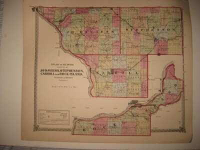
$4.00 Shipping Location: United States Click Here. Double your traffic. Get Vendio Gallery- Now FREE! Vintage antique 1875 handcolored map. Very nicely printed on thick paper. No printing on ... moreverso. This is an antique 1875 map and not a reprint or reproduction. The superb handcoloring on the map is period, this is before color printing. The map is in gorgeous, very superb condition. The map is titled, in fancy antique lettering,Atlas of Illinois, Counties of Jo Daviess, Stephenson, Carroll and Rock Island, Warner& Beers, Publishers. Amazing period map. There is a detailed References chart, corresponding to the map itself, with Townships County Seats, Towns, Post Offices, Creeks, Railroads finished, Railroads projected, and Public Lands, corresponding to the map. Beautifully detailed period map of these areas at this time. Warner and Beers were very highly regarded mapmakers of this period. The map is printed on fine thick paper, with no printing on reverse, fine outside ornate border as well. This is an antique map and not a reprint or reproduction. The map is from the very rare 1875 Illustrated Historical Atlas of Macoupin County Illinois. The map is a fascinating and historic period look at this area at this time. The photo wont show the full beauty of the map. The map is in nice shape and would frame and display quite beautifully. The size of the map is 16" by 18.5" Winning bidder pays $4.00 shipping domestic, more foreign. Payment I accept the following forms of payment: PayPal Click to View Image Album Shipping& Handling US Shipping. $4.00 USPS First-Class Mail® International Shipping. $11.50 USPS First-Class Mail International FREE scheduling. Supersized images and templates. Get Vendio Sales Manager. FREE scheduling. Supersized images and templates. Get Vendio Sales Manager.
Buy It Now
$4.00 Shipping Location: United States Printed on thick paper, with no printing on verso. This is an antique map and not a reprint or reproduction. The handcoloring on the map is period to ... morethe map, this is before color printing. The map is from the very rare 1875 LH Everts Atlas of Fayette County Ohio.
Buy It Now
$4.00 Shipping Location: Winter Springs, United States Detailed explanation chart at upper right hand side corresponding to the map itself. Large and attractive period map of these aras, much has changed. ... morePrinted on very thick paper. This is an antique map and not a reprint or reproduction.
Buy It Now
$4.00 Shipping Location: United States The map is titled, in fine fancy antique lettering, Atlas of Illinois, Counties of Macon, Christian, Shelby & Moultrie, Warner & Beers, Publishers, with ... moredetailed References chart corresponding to the map itself.
Buy It Now
$4.00 Shipping Location: United States This is an antique map and not a reprint or reproduction. The map is from the very rare 1875 Hardesty Atlas of Henry County Ohio. The photo wont show ... morethe full beauty of the map. The size of the map is large 13.5" by 19.5".
Buy It Now
$4.00 Shipping Location: United States The map is titled, in fine fancy antique lettering, Atlas of Illinois, Counties of Fayette, Effingham, Clay and Marion, Warner & Beers, Publishers, with ... moredetailed References chart corresponding to the map itself.
Buy It Now
$4.00 Shipping Location: United States The map is titled, in fine fancy antique lettering, Atlas of Illinois, Counties of Whiteside, Henry and Bureau, small tear at lower right hand side I ... moreneatly repaired with archival tape on versp., Warner & Beers, Publisheres, with detailed References chart corresponding to the map itself.
Buy It Now
$25.00 Shipping Location: Belvedere Tiburon, United States While this particular map is undated, we feel comfortable tentatively proposing a date around 1915. We already noted how our map shows the Permian Basin ... moreas unexploited, which pushes it back before the first serious prospections in 1920.
Buy It Now
$4.00 Shipping Location: United States The map is titled, in fine fancy antique lettering, Atlas of Illinois, Counties of Douglas, Coles, Cumberland, Clark & Edgar, Warner & Beers, Publishers, ... morewith detailed References chart corresponding to the map itself.
Buy It Now
$20.08 Shipping Location: HASTINGS, United Kingdom This map is dated August 1875 bottom right! The "Preis 60 kr" bottom left suggests it is a Swedish map. Condition: A little foxing evident, and the odd ... moresmall crease, but generally the map is in a good condition.

Buy It Now
$3.95 Shipping Location: Clarkston, United States Click Here. Double your traffic. Get Vendio Gallery- Now FREE! FOR MANY MORE EDUCATIONAL CD TITLES ON THIS AND MANY OTHER SUBJECTS NO ADDITIONAL SHIPPING ... moreON MULTIBLE CD ORDERS-ONLY $3.50 FOR ANY NUMBER OF CDs SHIPPED TO THE SAME ADDRESS IN THE US. ONLY $4.50 FOR ANY NUMBER TO ANYWHERE ELSE IN THE WORLD VERY LARGE HIGH RESOLUTION MAP COLLECTION ON CD-ROM! please see full table of contents and sample illustrations below) This CD Contains 56 Maps of The Polar regions Antarctica. Artic, North Pole South Pole These are scans of the ORIGINAL maps on CD-ROM System requirements PC or Mac compatible. Files are simple JPEG images with a basic HTML interface(just like viewing a webpage) Works with all versions of Windows including 3.1. 95, 98, 2000 or XP. Features of this CD-ROM This auction is for a CD-ROM of the maps listed in electronic form. NOT the maps themselves. These maps are VERY high resolution and can be printed at FULL SCALE or LARGER for framing and display. The results are very high quality and convincing. For a sample map please: WARNING! This is a LARGE file(5 Megabytes) if you are using a slow connection it can take some time to load. 0149009 Colton. G.W. 1856 Northern Regions. 0149010 Colton. G.W. 1856 Southern Regions. 0346001 Jefferys. Thomas 1776 Chart containing part of the Icy Sea. Greenland. Islands about Baffins Bay and part of Hudsons Bay. 0346005 Jefferys. Thomas 1776 The Russian Discoveries 0523001 Mitchell. Samuel Augustus 1839 World. Equatorial Projection and Polar Projection. 1007082 Thomson. John 1822 Arctic Regions. 12 NOVA ZEMBLA Johannes van Keulen 1680 Contemporary map users were intrigued by a map of the island in the Arctic Ocean because of the remembrance of the rigours of the arctic winter suffered by the first Dutch arctic explorer Willem Barendtsz(c. 1550-1597) During his last visit to the island in 1597 Barendtsz got stuck in the ice and. While he was unprepared, he and his crew had to stay the winter in Nova Zembla. 1801002 Desmarest. Nicolas, 1725-1815; Bory d
Buy It Now
$3.95 Shipping Location: Clarkston, United States Chart of part of coast of England, Holland & Flanders &c. England, Wales. England, Wales Roman, modern. United Kingdom of England, Scotland and Ireland. ... moreEngland, Wales. VERY LARGE HIGH RESOLUTION.
Buy It Now
$14.99 Shipping Location: Ivanhoe, Australia Louis Vivien, or Vivien de Saint-Martin was a French geographer who was born in Saint-Martin-de-Fontenay and died in Versailles, France in 1896. This ... morefinely engraved original large antique map of Spain & Portugal by Louis Vivien in his Elephant Folio atlas,Atlas Universal.
Buy It Now
$9.99 Shipping Location: Rosanna, Australia This original steel-plate engraved antique map by Alexander Findlay was published by Thomas Kelly in the 1835 edition of Barclays English Dictionary. ... more(Ref: M&B; Tooley). Findlay was born in London, 6 January 1812, a descendant of the Findlays of Arbroath, Forfarshire.
Buy It Now
$2.75 Shipping Location: Winter Springs, United States Click Here. Double your traffic. Get Vendio Gallery- Now FREE! Superb. In very fine conditon, vintage antique 1894 map, titled Chart of South Pass, Mississippi ... moreRiver. Map is in attractive horizontal format. Lower right hand side has date of 1894, this dates the map nicely. Very detailed and attractive period map, I see many fascianting areas. The map is in beautiful conditon and would frame and display nicely. The size is 32" by 10" Rare. Winning bidder pays $3.25 shipping domestic, more foreign. Payment I accept the following forms of payment: PayPal Preferred Checkout For fastest processing of this order. Please use Vendio Checkout! Click to View Image Album Shipping& Handling $3.25 USPS FREE scheduling. Supersized images and templates. Get Vendio Sales Manager. FREE scheduling. Supersized images and templates. Get Vendio Sales Manager. Win more auctions at the last minute FREE. Learn how.
Buy It Now
$31.44 Shipping Location: NUNEATON, United Kingdom Admiralty Chart 1895 , Antique Map, Dover Strait - 1875 Edition.
Buy It Now
$31.44 Shipping Location: NUNEATON, United Kingdom Admiralty Chart 1895 , Antique Map, Dover Strait - 1875 Edition.
Buy It Now
$15.00 Shipping Location: Brooklyn, United States The map depicts the world from East Africa to Fiji and from Taiwan and the Persian Gulf to 60 degrees south latitude. Manuscript pencil notations trace ... moreat least three, possibly four, voyages across the Indian Ocean.
Buy It Now
$9.99 Shipping Location: Rosanna, Australia This original copper-plate engraved antique map by Alexander Findlay and was published by Thomas Kelly in the 1835 edition ofBarclays English Dictionary. ... more(Ref: M&B; Tooley). Findlay was born in London, 6 January 1812, a descendant of the Findlays of Arbroath, Forfarshire.
Buy It Now
$10.04 Shipping Condition: Unspecified Location: LONDON, United Kingdom Title of map:'Egypte'. Antique map, 1875. DATE PRINTED: 1875. The image below shows an enlarged cross section from the centre of the map to show the level ... moreof printed detail. This map is folding hence the centrefold line may show on the image below.
Buy It Now
$3.95 Shipping Location: Clarkston, United States This DVD is part of our Historic Map and Atlas Collection. The results are very high quality and convincing. 0149013 Colton, G.W. New Brunswick, Nova ... moreScotia, … 1856 0149014 Colton, G.W. Canada East Or Lower Canada … 1856.
Buy It Now
$9.99 Shipping Location: Ivanhoe, Australia Ref#: - 40119. Findlay was born in London, 6 January 1812, a descendant of the Findlays of Arbroath, Forfarshire. Findlay\\\'s father, Alexander Findlay ... morewas one of the original fellows of the Royal Geographical Society.
Buy It Now
$10.04 Shipping Condition: Used Location: LONDON, United Kingdom 'African explorations since 1875'. Title of map:'African explorations since 1875'. Antique wood-engraved map; Scale 1:28,000,000, 1885. DATE PRINTED: ... more1885. The image below shows an enlarged cross section from the centre of the map to show the level of printed detail.
Buy It Now
$20.16 Shipping Location: CHIPPENHAM, United Kingdom C1858: Germany by J & C Walker & Raglovich, Keller, Fallon. Raglovich, Keller, Fallon. Atlas Map. J & C Walker (fl. J & C Walker. Germany [Deutschland ... moreIII. Baden, Wurtemberg, Bavaria, Tyrol, and Switzerland.]. ).
Buy It Now
$14.00 Shipping Location: Beograd 6, Serbia The nautical chart of Sri Lanka and Approaches to Colombo Harbour. Originally made in 1875 under the authority of the Crown. Reprinted in 1975 under the ... moresuperintendence of Rear Admiral G. P. D. Hall, Hydrographer of the Navy.
Buy It Now
$10.04 Shipping Condition: Unspecified Location: LONDON, United Kingdom Antique engraved map with original hand colour/color, 1875. DATE PRINTED: 1875. Title of map:'Kentucky and Tennessee'. 'Kentucky and Tennessee'. CONDITION: ... moreGood; suitable for framing.
Buy It Now
$28.68 Shipping Location: CHIPPENHAM, United Kingdom C1853: Switzerland by Alex Findlay. Alexander George Findlay (1812 - 1875), English geographer and hydrographer, descendant of the Findlays of Arbroath, ... moreForfarshire. Findlay's father, Alexander Findlay was one of the original fellows of the Royal Geographical Society.
Buy It Now
$9.99 Shipping Location: Rosanna, Australia This original copper-plate engraved antique map by Alexander Findlay and was published by Thomas Kelly in the 1835 edition ofBarclays English Dictionary. ... more(Ref: M&B; Tooley). Findlay was born in London, 6 January 1812, a descendant of the Findlays of Arbroath, Forfarshire.
Buy It Now
$9.99 Shipping Location: Rosanna, Australia Ref#: - 21160. This original copper-plate engraved antique map by Alexander Findlay and was published by Thomas Kelly in the 1835 edition ofBarclays English ... moreDictionary. (Ref: M&B; Tooley). Findlay was born in London, 6 January 1812, a descendant of the Findlays of Arbroath, Forfarshire.
Buy It Now
$9.99 Shipping Location: Rosanna, Australia Ref#: - 21164. This original copper-plate engraved antique map by Alexander Findlay and was published by Thomas Kelly in the 1835 edition ofBarclays English ... moreDictionary. (Ref: M&B; Tooley). Findlay was born in London, 6 January 1812, a descendant of the Findlays of Arbroath, Forfarshire.
Buy It Now
$11.92 Shipping Location: ILKLEY, United Kingdom This 6th edition which was printed from 1875-1881 is generally regarded as the edition in which the work reached the high scientific level and the unsurpassed ... morerelief Stieler's Atlas is famous for. There is a centrefold as published.
Buy It Now
$10.04 Shipping Condition: Unspecified Location: LONDON, United Kingdom Antique steel engraved map, 1875. DATE PRINTED: 1875. The image below shows an enlarged cross section from the centre of the map to show the level of ... moreprinted detail. This map is folding hence the centrefold line may show on the image below.
Buy It Now
$15.00 Shipping Location: New York, United States The map depicts the theater of war in the Netherlands during the Napoleonic and French Revolutionary Wars. Scale sticks lower left. Verso blank. ," Thomas ... moreKitchin & others. About the publishers Laurie & Whittle.
Buy It Now
$30.00 Shipping Location: Paris VI, France "OCEAN PACIFIQUE. The map has been realised from the readings established during the expedition in the Pacific of the Naval division ordered by the contre-amiral ... moreGermain-Hector Périgot (1816-1900) in 1874-1877.
Buy It Now
Free Shipping Location: Oley, United States S. Crawford Smith was a Philadelphia draftsman. S. Crawford Smith. Map of the Centennial Grounds, Phila., PA 1875, S. Crawford Smith, T. Hunter. Map was ... moredesigned "from authentic surveys corrected & approved by the Centennial Commissioners,".
Buy It Now
$4.00 Shipping Location: United States The map is titled, in fine fancy antique lettering, Atlas of Illinois, Counties of Jasper, Crawford, Lawrence, Richland, Edwards & Wabash, Warner & Beers, ... morePublisheres, with detailed References chart corresponding to the map itself.
Buy It Now
$9.99 Shipping Location: Ivanhoe, Australia Findlay was born in London, 6 January 1812, a descendant of the Findlays of Arbroath, Forfarshire. Findlay\\\'s father, Alexander Findlay was one of the ... moreoriginal fellows of the Royal Geographical Society.
Buy It Now
$9.99 Shipping Location: Ivanhoe, Australia Findlay was born in London, 6 January 1812, a descendant of the Findlays of Arbroath, Forfarshire. Findlay\\\'s father, Alexander Findlay was one of the ... moreoriginal fellows of the Royal Geographical Society.
Buy It Now
$9.99 Shipping Location: Ivanhoe, Australia Findlay was born in London, 6 January 1812, a descendant of the Findlays of Arbroath, Forfarshire. Findlay\\\'s father, Alexander Findlay was one of the ... moreoriginal fellows of the Royal Geographical Society.
Buy It Now
$21.33 Shipping Condition: Unspecified Location: LONDON, United Kingdom 'Africa - East Coast - Pangani to Ras Kimbiji including the approaches to Zanzibar'. Title of map:'Africa - East Coast - Pangani to Ras Kimbiji including ... morethe approaches to Zanzibar'. PROVENANCE: London.
Buy It Now
$9.99 Shipping Location: Ivanhoe, Australia This original copper plate engraved antique map of North Africa by Alexander Findlay was published in the 1835 edition of Findlay'sClassical Atlas, W. ... moreTegg and Co. Findlay was born in London, 6 January 1812, a descendant of the Findlays of Arbroath, Forfarshire.

Buy It Now
$3.95 Shipping Location: Clarkston, United States Rare Map Collection This DVD is part of our Historic Map and Atlas Collection. We have dozens of Atlas maps on DVD and CD ranging from the 1500s to the ... more1900s covering many areas and topics. Please Check our Ebay Store for what's available. FOR MANY MORE EDUCATIONAL CD TITLES ON THIS AND MANY OTHER SUBJECTS PLEASE VISIT OUR EBAY STORE VERY LARGE HIGH RESOLUTION MAP COLLECTION ON DVD! please see full table of contents and sample illustrations below) This DVD Contains 210 Maps of Florida Including 13 PANORAMIC MAPS of various Florida Cities These are scans of the ORIGINAL maps by various Cartographers. on DVD System requirements PC or Mac compatible. Files are simple PDF files with a basic HTML interface(just like viewing a webpage) Works with ALL versions of Windows. Maps of Florida 0041011 Florida Asher& Adams 1874, 0089031 Florida Bradford. Thomas G. 1838, 0104008 Florida Burr. David H 1839, 0122032 Florida Carey. H. C 1822, 0149036 Florida Colton. G.W. 1856, 0278013 Florida Finley. Anthony 1826, 0285031 Florida Finley. Anthony 1831, 0346029 Coast Of West Florida and Louisiana.with the Bahama Islands. Jefferys. Thomas 1776, 0537022 Florida Mitchell. Samuel Augustus 1845, 0565018 County Map Of Florida. Mitchell. Samuel Augustus 1860, 0586026 Florida. Mobile Mitchell. Samuel Augustus 1880, 0594027 Florida Mitchell. Samuel Augustus 1890, 0632022 East and West Florida Morse. Jedidiah 1794, 0890141 Florida Society for the Diffusion of Useful Knowledge(Great Britain) 1834, 0977018 Florida Tanner. Henry S. 1836, 1070014 Florida U.S. General Land Office 1866, 1780149 Florida. Gen. map XI Julius Bien& Co. United States. War Department 1895, 1780150 Florida. Gen. map XII Julius Bien& Co. United States. War Department 1895, 2209000 Map Of The Seat Of War In Florida Hood. Washington 1838, 2212268 Florides et Iles Lucayes Vandermaelen. Philippe 1827, 2239030 Florida. Georgia, and South Carolina Lloyd. H. H. 1873, 2301031 Florida Morse. Sidney Edwards) Breese, Samuel 1845, 2329007 Floride. Delta du Mississippi
|
|
|
In
|
1875 Map, Chart, "Coast of South Carolina including Pimlico & Albemarle Sounds'
1875 Map. Chart, Coast of South Carolina including Pimlico& Albemarle Sounds' Click to Enlarge Click to Enlarge Description: You are bidding on original period maps. We will be offering numerous.1850s to the 1880s maps large and small. All are locations in and around the United States. The maps are in very good but used condition, some have foxing. Please use the photos for condition. The title and content of the map being offered is: 1875 Coast of South Carolina including Albermarle& Pimlico Sounds. 27 by 37 inches Shipping: Please wait until we send you an invoice to pay the shipping. Ebay's calculator isn't always in accord with the cheapest cost to ship. If you. The buyer, waits for us to invoice instead of Ebays automatic invoice the savings are occasionally substantial. Thanks You. Payment: PAYPAL. ETC. inkfrog terapeak. ... moreI000000. InkFrog Analytics.
|
|
|
1875 Map, Chart, "East Coast Florida, Halifax to Cape Canveral", Coast Survey
1875 Map. Chart, East Coast Florida, Halifax to Cape Canveral" Coast Survey Click to Enlarge Description: You are bidding on original period maps. We will be offering numerous.1850s to the 1880s maps large and small. All are locations in and around the United States. The maps are in very good but used condition, some have foxing. Please use the photos for condition. The title and content of the map being offered is: 1875- East Coast of Florida. Halifax River to Cape Canaveral, 15 by 32 inches. Shipping: Please wait until we send you an invoice to pay the shipping. Ebay's calculator isn't always in accord with the cheapest cost to ship. If you. The buyer, waits for us to invoice instead of Ebays automatic invoice the savings are occasionally substantial. Thanks You. Payment: PAYPAL. ETC. inkfrog terapeak. I000000. InkFrog Analytics.
|
|
|
1875 Map, Chart, "East Coast Florida, Amelia Island to Halifax", Coast Survey
1875 Map. Chart, East Coast Florida, Amelia Island to Halifax" Coast Survey Click to Enlarge Description: You are bidding on original period maps. We will be offering numerous.1850s to the 1880s maps large and small. All are locations in and around the United States. The maps are in very good but used condition, some have foxing. Please use the photos for condition. The title and content of the map being offered is: 1875- East Coast of Florida. Halifax River to Amelia Island, 15 by 32 inches. Shipping: Please wait until we send you an invoice to pay the shipping. Ebay's calculator isn't always in accord with the cheapest cost to ship. If you. The buyer, waits for us to invoice instead of Ebays automatic invoice the savings are occasionally substantial. Thanks You. Payment: PAYPAL. ETC. inkfrog terapeak. I000000. InkFrog Analytics. ... moreRcmdId ViewItemDescV4,RlogId p4%60bo7%60jtb9%3Fvo%7B%3Dd70f%2Bf%60%60%3E-1400616e518-0xfd-
|
|
|
Antique 1875 Map Chart "West Coast Florida, Tampa Bay & Vicinity" Coast Survey
Antique 1875 Map Chart"West Coast Florida. Tampa Bay& Vicinity" Coast Survey Click to Enlarge Description: You are bidding on original period maps. We will be offering numerous.1850s to the 1880s maps large and small. All are locations in and around the United States. The maps are in very good but used condition, some have foxing. Please use the photos for condition. The title and content of the map being offered for bid is 1875- West Coast of Florida. Tampa Bay and Vicinity, 16 by 32 inches. Shipping: Please wait until we send you an invoice to pay the shipping. Ebay's calculator isn't always in accord with the cheapest cost to ship. If you. The buyer, waits for us to invoice instead of Ebays automatic invoice the savings are occasionally substantial. Thanks You. Payment: PAYPAL. ETC. inkfrog terapeak. I000000. InkFrog ... moreAnalytics.
|
|
|
1875 Map Chart "West Coast Florida, St Joseph's Bay to Mobile Bay" Coast Survey
1875 Map Chart"West Coast Florida. St Joseph's Bay to Mobile Bay" Coast Survey Click to Enlarge Description: You are bidding on original period maps. We will be offering numerous.1850s to the 1880s maps large and small. All are locations in and around the United States. The maps are in very good but used condition, some have foxing. Please use the photos for condition. The title and content of the map being offered for bid is 1875- West Coast of Florida. St Joseph Bay to Mobile Bay, 23.5 by 37 inches Shipping: Please wait until we send you an invoice to pay the shipping. Ebay's calculator isn't always in accord with the cheapest cost to ship. If you. The buyer, waits for us to invoice instead of Ebays automatic invoice the savings are occasionally substantial. Thanks You. Payment: PAYPAL. ETC. inkfrog terapeak. I000000. ... moreInkFrog Analytics.
|
|
|
ANTIQUE 1875 MAP, CHART "COAST OF TEXAS" 32 BY 28 INCHES
ANTIQUE 1875 MAP. CHART"COAST OF TEXAS" 32 BY 28 INCHES Click to Enlarge Description: You are bidding on original period maps. We will be offering numerous.1850s to the 1880s maps large and small. All are locations in and around the United States. The maps are in very good but used condition, some have foxing. Please use the photos for condition. The title and content of the map offered 1848- 1875- COAST OF TEXAS. 32 BY 28 INCHES Shipping: Please wait until we send you an invoice to pay the shipping. Ebay's calculator isn't always in accord with the cheapest cost to ship. If you. The buyer, waits for us to invoice instead of Ebays automatic invoice the savings are occasionally substantial. Thanks You. Payment: PAYPAL. ETC. inkfrog terapeak. I000000. InkFrog Analytics.
|
|
|
ANTIQUE 1875 MAP, CHART "TOMALES BAY TO PT SAL" 31 BY 21 INCHES
ANTIQUE 1875 MAP. CHART"SAN DIEGO TO PT SAL" 31 BY 21 INCHES Click to Enlarge Description: You are bidding on original period maps. We will be offering numerous.1850s to the 1880s maps large and small. All are locations in and around the United States. The maps are in very good but used condition, some have foxing. Please use the photos for condition. The title and content of the map offered 1850- 1875- CALIFORNIA. TOMALES BAY TO PT SAL, 31 BY 21 INCHES Shipping: Please wait until we send you an invoice to pay the shipping. Ebay's calculator isn't always in accord with the cheapest cost to ship. If you. The buyer, waits for us to invoice instead of Ebays automatic invoice the savings are occasionally substantial. Thanks You. Payment: PAYPAL. ETC. inkfrog terapeak. I000000. InkFrog Analytics.
|
|
|
1875 Map, Chart "NYC to Cape Henlopen" New York City, 21"x 25", Coast Survey
1875 Map. Chart"NYC to Cape Henlopen" New York City, 21"x 25" Coast Survey Click to Enlarge Description: You are bidding on original period maps. We will be offering numerous.1850s to the 1880s maps large and small. All are locations in and around the United States. The maps are in very good but used condition, some have foxing. Please use the photos for condition. The title and content of the map being offered is: 1875- TRIANGULATION& GEOGRAPHICAL POSITIONS IN SECTION II FROM NEW YORK CITY TO CAPE HENLOPEN. 21 BY 25 INCHES. Shipping: Please wait until we send you an invoice to pay the shipping. Ebay's calculator isn't always in accord with the cheapest cost to ship. If you. The buyer, waits for us to invoice instead of Ebays automatic invoice the savings are occasionally substantial. Thanks You. Payment: PAYPAL. ... moreETC. inkfrog terapeak. I000000. InkFrog Analytics. 560.RcmdId ViewItemDescV4,RlogId p4%60bo7%60jtb9%3Feog4d72f%2B%3E560-140133cbe9c-0x103-
|
|
|
1875 Map, Chart "CHESAPEAKE BAY & TRIBUTARIES" Coast Survey, 26"X36"
1875 Map. Chart"CHESAPEAKE BAY& TRIBUTARIES" Coast Survey, 26"X36" Click to Enlarge Description: You are bidding on original period maps. We will be offering numerous.1850s to the 1880s maps large and small. All are locations in and around the United States. The maps are in very good but used condition, some have foxing. Please use the photos for condition. The title and content of the map being offered is: 1843-1875 CHESAPEAKE BAY AND TRIBUTARIES. 26 BY 36 INCHES Shipping: Please wait until we send you an invoice to pay the shipping. Ebay's calculator isn't always in accord with the cheapest cost to ship. If you. The buyer, waits for us to invoice instead of Ebays automatic invoice the savings are occasionally substantial. Thanks You. Payment: PAYPAL. ETC. inkfrog terapeak. I000000. InkFrog Analytics.
|
|
|
1875 Map, Chart "ATLANTIC, GULF OF MEXICO & PACIFIC COAST" COAST SURVEY
1875 Map. Chart"ATLANTIC, GULF OF MEXICO& PACIFIC COAST" COAST SURVEY Click to Enlarge Description: You are bidding on original period maps. We will be offering numerous.1850s to the 1880s maps large and small. All are locations in and around the United States. The maps are in very good but used condition, some have foxing. Please use the photos for condition. The title and content of the map being offered is; 1875- ATLANTIC. GULF OF MEXICO& PACIFIC COAST, 26 BY 27 INCHES Shipping: Please wait until we send you an invoice to pay the shipping. Ebay's calculator isn't always in accord with the cheapest cost to ship. If you. The buyer, waits for us to invoice instead of Ebays automatic invoice the savings are occasionally substantial. Thanks You. Payment: PAYPAL. ETC. inkfrog terapeak. I000000. InkFrog Analytics.
|
|
|
1875 Map, Chart "PORTLAND, MAINE COAST" COAST SURVEY 21"X30"
1875 Map. Chart"PORTLAND, MAINE COAST" COAST SURVEY 21"X30" Click to Enlarge Description: You are bidding on original period maps. We will be offering numerous.1850s to the 1880s maps large and small. All are locations in and around the United States. The maps are in very good but used condition, some have foxing. Please use the photos for condition. The title and content of the map being offered is; 1875- PORTLAND. MAINE COAST, 21 BY 30 INCHES Shipping: Please wait until we send you an invoice to pay the shipping. Ebay's calculator isn't always in accord with the cheapest cost to ship. If you. The buyer, waits for us to invoice instead of Ebays automatic invoice the savings are occasionally substantial. Thanks You. Payment: PAYPAL. ETC. inkfrog terapeak. I000000. InkFrog Analytics.
|
|
|
1875 Map, Chart "HUDSON & ST CROIX RIVERS" COAST SURVEY, 24"X27"
1875 Map. Chart"HUDSON& ST CROIX RIVERS" COAST SURVEY, 24"X27" Click to Enlarge Description: You are bidding on original period maps. We will be offering numerous.1850s to the 1880s maps large and small. All are locations in and around the United States. The maps are in very good but used condition, some have foxing. Please use the photos for condition. The title and content of the map being offered is; 1875- PRIMARY TRIANGULATION BETWEEN HUDSON& ST CROIX RIVERS. 24 BY 27 INCHES Shipping: Please wait until we send you an invoice to pay the shipping. Ebay's calculator isn't always in accord with the cheapest cost to ship. If you. The buyer, waits for us to invoice instead of Ebays automatic invoice the savings are occasionally substantial. Thanks You. Payment: PAYPAL. ETC. inkfrog terapeak. I000000. InkFrog ... moreAnalytics.
|
|
|
1875 Map, Chart "NEW YORK CITY to POINT JUDITH" COAST SURVEY, 17"X28"
1875 Map. Chart"NEW YORK CITY to POINT JUDITH" COAST SURVEY, 17"X28" Click to Enlarge Description: You are bidding on original period maps. We will be offering numerous.1850s to the 1880s maps large and small. All are locations in and around the United States. The maps are in very good but used condition, some have foxing. Please use the photos for condition. The title and content of the map being offered is; 1875- TRIANGULATION& GEOGRAPHICAL POSITIONS FROM NYC TO POINT JUDITH. 17 BY 28 INCHES Shipping: Please wait until we send you an invoice to pay the shipping. Ebay's calculator isn't always in accord with the cheapest cost to ship. If you. The buyer, waits for us to invoice instead of Ebays automatic invoice the savings are occasionally substantial. Thanks You. Payment: PAYPAL. ETC. inkfrog terapeak. I000000. ... moreInkFrog Analytics.
|
|
 |