-
Christian Collectibles
-
Christian Sheet Music
-
Vatican Stamps
-
Vatican Coins & Paper Money
-
Antiques
-
Antiquities
-
Architectural & Garden
-
Decorative Arts
-
Ethnographic
-
Furniture
-
Maps, Atlases & Globes
-
United States (Pre-1900)
-
AK, HI
-
AL, FL, GA, MS, NC, SC
-
AR, IA, KS, LA, MO, NE
-
AZ, CA, CO, NM, NV, UT
-
CT, MA, ME, NH, RI, VT
-
DC, DE, MD, NJ, NY, PA
-
ID, OR, WA
-
IL, IN, MI, OH, WI
-
MN, MT, ND, SD, WY
-
OK, TX
-
VA, WV, KY, TN
-
Entire US
-
United States (1900-Now)
-
United States (Date Unknown)
-
Africa
-
Asia
-
Australasia/ Oceania
-
Canada
-
Central America/ Caribbean
-
Europe
-
India
-
Ireland
-
Mexico
-
Middle East
-
North America
-
South America
-
United Kingdom
-
Maps on CD
-
World Maps
-
Globes
-
Mixed Lots
-
Reproductions
-
Price Guides & Publications
-
Other
|
In
Order by: Available to: This site contains affiliate links for which I may be compensated
|
Buy It Now
Free Shipping Location: Kennebunk, United States This Map was removed from a 1884 Atlas and is in good acceptable condition. Study the photos carefully, this is the actual map you. Only Authentic Originals.
Buy It Now
$4.00 Shipping Location: United States The map is titled Bristol, I see Centre, Polkville, Forestvillle, and more. Many fascianting, detailed areas. This is an antique map and not a reprint ... moreor reproduction. The map is in excellent condition.
Buy It Now
$14.60 Shipping Location: Commack, United States This map can be found at In general, I have cleaned the item very lightly for any bulk surface dust, dirt, etc. I have NOT deep cleaned it and will not ... morebe doing so here. The item is as shown in the photos.
Buy It Now
$4.00 Shipping Location: Winter Springs, United States Fine, very rare, attractive, large antique 1931 lithographed map, showing West Suffield, East Granby and more. Printed on very thick paper, with no printing ... moreon reverse. Very finely produced period map.
Buy It Now
$4.00 Shipping Location: United States The map is titled Berlin. Many fascianting, detailed areas. This is an antique map and not a reprint or reproduction. Overall map is in nice condition. ... moreVery rare. The handcoloring on the map is period to the map, this is before color printing.
Buy It Now
$4.00 Shipping Location: United States The map is titled Burlington, I see Burlington, Whigville and more. Many fascianting, detailed areas. This is an antique map and not a reprint or reproduction. ... moreThe map is in excellent condition. Very rare.
Buy It Now
$4.00 Shipping Location: Winter Springs, United States Printed on very thick paper, with no printing on reverse. Very finely produced period map. The size of the map is 16" by 20.5". FREE scheduling, supersized ... moreimages.
Buy It Now
$4.00 Shipping Location: United States The map is titled Suffield, West Suffield and Windsor Locks. Many fascianting, detailed areas. This is an antique map and not a reprint or reproduction. ... moreOverall map is in nice condition. Very rare.
Buy It Now
$4.00 Shipping Location: United States The map is titled Windsor, with inset map of Poquonnock, and Rainbow. Many fascianting, detailed areas. This is an antique map and not a reprint or reproduction. ... moreOverall map is in nice condition.
Buy It Now
$4.00 Shipping Location: United States The map is titled East Hartford, I see East Hartford PO, Burnside PO and moe. The map has a light stain at bottom area, not that bad at all. Many fascianting, ... moredetailed areas. This is an antique map and not a reprint or reproduction.
Buy It Now
$4.00 Shipping Location: United States The map is titled East Hartford, and at top is South Windsor and East Windsor Hill. Many fascianting, detailed areas. This is an antique map and not a ... morereprint or reproduction. Overall map is in nice condition.
Buy It Now
$16.40 Shipping Location: Newtown, United States Connecticut Hartford County Map Bristol Township 1869. Shipped with USPS First Class.
Buy It Now
$4.00 Shipping Location: Winter Springs, United States Printed on very thick paper, with no printing on reverse. Very finely produced period map. The size of the map is 16" by 20.5". FREE scheduling, supersized ... moreimages.
Buy It Now
$12.45 Shipping Location: Newtown, United States
Buy It Now
$12.45 Shipping Location: Newtown, United States
Buy It Now
$20.40 Shipping Location: Newtown, United States ANTIQUE 1869 THOMPSONVILLE ENFIELD HARTFORD COUNTY CONNECTICUT HANDCOLORED MAP. Shipped with USPS First Class.
Buy It Now
$13.60 Shipping Location: Portland, United States Places: Hartford County Connecticut. Year Published: 1976.
Buy It Now
$4.00 Shipping Location: United States The map is titled Marlborough, with inset map of Marlborough Mills. Many fascianting, detailed areas. This is an antique map and not a reprint or reproduction. ... moreOverall map is in nice condition. Very rare.
Buy It Now
$4.00 Shipping Location: United States The map is titled Rocky Hill, with inset map of Rocky Hill. Many fascianting, detailed areas. This is an antique map and not a reprint or reproduction. ... moreOverall map is in nice condition. Very rare.
Buy It Now
$4.00 Shipping Location: United States The map is titled East Granby, with inset map titled East Granby. Many fascianting, detailed areas. This is an antique map and not a reprint or reproduction. ... moreThe map is in excellent condition. Very rare.
Buy It Now
$4.00 Shipping Location: United States And Enfield (Enfield Tp.). Many fascianting, detailed areas. This is an antique map and not a reprint or reproduction. Overall map is in nice condition. ... moreVery rare. The handcoloring on the map is period to the map, this is before color printing.
Buy It Now
$3.75 Shipping Location: United States The map is titled East Granby, with inset map titled East Granby. Many fascianting, detailed areas. This is an antique map and not a reprint or reproduction. ... moreThe map is in excellent condition. Very rare.
Buy It Now
$4.00 Shipping Location: United States Many fascianting, detailed areas. This is an antique map and not a reprint or reproduction. The map is in excellent condition. Very rare. The handcoloring ... moreon the map is period to the map, this is before color printing.
Buy It Now
$4.00 Shipping Location: United States Many fascianting, detailed areas. This is an antique map and not a reprint or reproduction. Overall map is in nice condition. Very rare. The handcoloring ... moreon the map is period to the map, this is before color printing.
Buy It Now
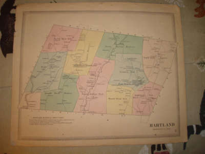
$4.00 Shipping Location: United States The map is titled Hartland. Many fascianting, detailed areas. This is an antique map and not a reprint or reproduction. The map is in excellent condition. ... moreVery rare. The handcoloring on the map is period to the map, this is before color printing.
Buy It Now
$4.00 Shipping Location: United States The map is titled Rocky Hill, with Rocky Hill inset map. Many fascianting, detailed areas. This is an antique map and not a reprint or reproduction. Overall ... moremap is in nice condition. Very rare. The handcoloring on the map is period to the map, this is before color printing.
Buy It Now
$4.00 Shipping Location: United States The map is titled Windsor. Many fascianting, detailed areas. This is an antique map and not a reprint or reproduction. Overall map is in nice condition. ... moreVery rare. The handcoloring on the map is period to the map, this is before color printing.

Buy It Now
$4.00 Shipping Location: United States Click Here. Double your traffic. Get Vendio Gallery- Now FREE! Vintage antique 1869 handcolored map. The map is titled Hockanum. Burnside, east Hartford) ... moreand Naubic and Vicinity. Many fascianting, detailed areas. The map shows the home and land owners, the business and industry, the few roads, railroads etc that existed at that time. This is an antique map and not a reprint or reproduction. The map has a Brooklyn Public Library hole stamp on it, see my photo. Overall map is in nice condition. Very rare. The handcoloring on the map is period to the map, this is before color printing. The map is from the very rare 1869 Baker and Tilden Atlas of Hartford County Connecticut. The map is a fascinating and historic period look at this area at this time. The map is in nice shape and would frame and display quite beautifully. The size of the map is 14.5" by 17.5" Winning bidder pays $4.00 shipping domestic, more foreign. Payment I accept the following forms of payment: PayPal Click to View Image Album Shipping& Handling US Shipping. $4.00 USPS First-Class Mail® International Shipping. $11.50 USPS First-Class Mail International FREE scheduling. Supersized images and templates. Get Vendio Sales Manager. FREE scheduling. Supersized images and templates. Get Vendio Sales Manager.
Buy It Now
$12.45 Shipping Location: Newtown, United States In good condition as shown P1.
Buy It Now
$16.40 Shipping Location: Newtown, United States Connecticut Hartford County Map Farmington Township 1869 J8#30. Shipped with USPS First Class.
Buy It Now
$12.45 Shipping Location: Newtown, United States In good condition as shown P1.
Buy It Now
Free Shipping Location: Stafford Springs, United States

Buy It Now
$4.00 Shipping Location: United States Click Here. Double your traffic. Get Vendio Gallery- Now FREE! Vintage antique 1869 handcolored map. The map is titled East Hartford. I see East Hartford ... morePO, Burnside PO, and much more. Many fascianting, detailed areas. The map shows the home and land owners, the business and industry, the few roads, railroads etc that existed at that time. This is an antique map and not a reprint or reproduction. The map has a Brooklyn Public Library hole stamp on it, see my photo. Overall map is in nice condition. Very rare. The handcoloring on the map is period to the map, this is before color printing. The map is from the very rare 1869 Baker and Tilden Atlas of Hartford County Connecticut. The map is a fascinating and historic period look at this area at this time. The map is in nice shape and would frame and display quite beautifully. The size of the map is 14.5" by 17.5" Winning bidder pays $4.00 shipping domestic, more foreign. Payment I accept the following forms of payment: PayPal Click to View Image Album Shipping& Handling US Shipping. $4.00 USPS First-Class Mail® International Shipping. $11.50 USPS First-Class Mail International FREE scheduling. Supersized images and templates. Get Vendio Sales Manager. FREE scheduling. Supersized images and templates. Get Vendio Sales Manager.

Buy It Now
$4.00 Shipping Location: Winter Springs, United States Click Here. Double your traffic. Get Vendio Gallery- Now FREE! Vintage antique 1869 handcolored map. The map is titled Bloomfield(Hartford Co. with inset ... moremap of Bloomfield. Many fascianting. Detailed areas. The map shows the home and land owners, size and locations of buildings, the business and industry, the few roads, railroads etc that existed at that time. This is an antique map and not a reprint or reproduction. Overall map is in nice condition. Very rare. The handcoloring on the map is period to the map, this is before color printing. The map is from the very rare 1869 Baker and Tilden Atlas of Hartford County Connecticut. The map is a fascinating and historic period look at this area at this time. The map is in nice shape and would frame and display quite beautifully. The size of the map is 14.5" by 17.5" Winning bidder pays $4.00 shipping domestic, more foreign. Payment I accept the following forms of payment: PayPal Click to View Image Album Shipping& Handling US Shipping. $4.00 USPS First-Class Mail® International Shipping. $11.50 USPS First-Class Mail International FREE scheduling. Supersized images and templates. Get Vendio Sales Manager. FREE scheduling. Supersized images and templates. Get Vendio Sales Manager.
Buy It Now
$4.00 Shipping Location: United States Many fascianting, detailed areas. This is an antique map and not a reprint or reproduction. Overall map is in nice condition. Very rare. The handcoloring ... moreon the map is period to the map, this is before color printing.

Buy It Now
$4.00 Shipping Location: Winter Springs, United States Click Here. Double your traffic. Get Vendio Gallery- Now FREE! Vintage antique 1869 handcolored map. Very rare The map is titled Bristol, I see South ... moreVillage, and North Village. The map has a light stain at extreme outside edge, bottom area, outside of the map imagery, if framed cna be covered. Many fascianting, detailed areas. The map shows the home and land owners, size and locations of buildings, the business and industry, the few roads, railroads etc that existed at that time. This is an antique map and not a reprint or reproduction. Overall map is in nice condition. Very rare. The handcoloring on the map is period to the map, this is before color printing. The map is from the very rare 1869 Baker and Tilden Atlas of Hartford County Connecticut. The map is a fascinating and historic period look at this area at this time. The map is in nice shape and would frame and display quite beautifully. The size of the map is 14.5" by 17.5" Winning bidder pays $4.00 shipping domestic, more foreign. Payment I accept the following forms of payment: PayPal Click to View Image Album Shipping& Handling US Shipping. $4.00 USPS First-Class Mail® International Shipping. $11.50 USPS First-Class Mail International FREE scheduling. Supersized images and templates. Get Vendio Sales Manager. FREE scheduling. Supersized images and templates. Get Vendio Sales Manager.
Buy It Now
$4.95 Shipping Location: Dover, United States Issued 1893, Boston by D. H. Hurd & Co. South Part of Hartford Co. Large late-19th century lithographed map with original hand color. (United States / ... moreNew England / Connecticut River- Berlin- Wethersfield- Rocky Hill- ).

Buy It Now
$4.00 Shipping Location: United States Click Here. Double your traffic. Get Vendio Gallery- Now FREE! Vintage antique 1869 handcolored map. The map is titled Hazardville(Enfield Township. I ... morese huge Hazard Powder Co. Works. With very detailed buildings, there, including Fortress Monroe and much more. Many fascianting, detailed areas. The map shows the home and land owners, the business and industry, the few roads, railroads etc that existed at that time. This is an antique map and not a reprint or reproduction. The map has a Brooklyn Public Library hole stamp on it, see my photo. Overall map is in nice condition. Very rare. The handcoloring on the map is period to the map, this is before color printing. The map is from the very rare 1869 Baker and Tilden Atlas of Hartford County Connecticut. The map is a fascinating and historic period look at this area at this time. The map is in nice shape and would frame and display quite beautifully. The size of the map is 14.5" by 17.5" Winning bidder pays $4.00 shipping domestic, more foreign. Payment I accept the following forms of payment: PayPal Click to View Image Album Shipping& Handling US Shipping. $4.00 USPS First-Class Mail® International Shipping. $11.50 USPS First-Class Mail International FREE scheduling. Supersized images and templates. Get Vendio Sales Manager. FREE scheduling. Supersized images and templates. Get Vendio Sales Manager. RcmdId ViewItemDescV4,RlogId p4%60bo7%60jtb9%3Fvo%7B%3Dd70f%2Bf52%3E-14050ea83c9-0xfe-
Buy It Now
$9.32 Shipping Location: Windsor Locks, United States Bundle Includes (2) Tolland County (Series 1961, No. 35; Issued December 1966); Both in Good Condition.
Buy It Now
$12.45 Shipping Location: Newtown, United States In good condition as shown P1.
Buy It Now
$3.75 Shipping Location: Winter Springs, United States Click Here. Double your traffic. Get Vendio Gallery- Now FREE! Vintage antique 1869 handcolored map. The map is titled Hartland. I see West Hartland, ... moreEast Hartland, and more. Many fascianting, detailed areas. The map shows the home and land owners, size and locations of buildings, the business and industry, the few roads, railroads etc that existed at that time. This is an antique map and not a reprint or reproduction. Overall map is in nice condition. Very rare. The handcoloring on the map is period to the map, this is before color printing. The map is from the very rare 1869 Baker and Tilden Atlas of Hartford County Connecticut. The map is a fascinating and historic period look at this area at this time. The map is in nice shape and would frame and display quite beautifully. The size of the map is 14.5" by 17.5" Winning bidder pays $4.00 shipping domestic, more foreign. Payment I accept the following forms of payment: PayPal Click to View Image Album Shipping& Handling US Shipping. $4.00 USPS First-Class Mail® International Shipping. $11.50 USPS First-Class Mail International FREE scheduling. Supersized images and templates. Get Vendio Sales Manager. FREE scheduling. Supersized images and templates. Get Vendio Sales Manager. a;06d2.RcmdId ViewItemDescV4,RlogId p4%60bo7%60jtb9%3Fuk.rp73%28%3Ea%3B06d2-148d09caf3c-0x10a-
Buy It Now
$14.60 Shipping Location: Commack, United States This map can be found at In general, I have cleaned the item very lightly for any bulk surface dust, dirt, etc. I have NOT deep cleaned it and will not ... morebe doing so here. The item is as shown in the photos.
Buy It Now
$4.00 Shipping Location: United States Many fascianting, detailed areas. This is an antique map and not a reprint or reproduction. Overall map is in nice condition. Very rare. The handcoloring ... moreon the map is period to the map, this is before color printing.

Buy It Now
$4.00 Shipping Location: Winter Springs, United States Click Here. Double your traffic. Get Vendio Gallery- Now FREE! Vintage antique 1869 handcolored map. The map is titled City of Hartford. Map of Part of ... more6th Ward. Many fascianting, detailed areas. The map shows the home and land owners, the business and industry, the few roads, railroads etc that existed at that time. This is an antique map and not a reprint or reproduction. The map has a Brooklyn Public Library hole stamp on it, see my photo. Overall map is in nice condition. Very rare. The handcoloring on the map is period to the map, this is before color printing. The map is from the very rare 1869 Baker and Tilden Atlas of Hartford County Connecticut. The map is a fascinating and historic period look at this area at this time. The map is in nice shape and would frame and display quite beautifully. The size of the map is 14.5" by 17.5" Winning bidder pays $4.00 shipping domestic, more foreign. Payment I accept the following forms of payment: PayPal Click to View Image Album Shipping& Handling US Shipping. $4.00 USPS First-Class Mail® International Shipping. $11.50 USPS First-Class Mail International FREE scheduling. Supersized images and templates. Get Vendio Sales Manager. FREE scheduling. Supersized images and templates. Get Vendio Sales Manager.
Buy It Now
$4.00 Shipping Location: United States The map is titled Windsor Locks. Many fascianting, detailed areas. This is an antique map and not a reprint or reproduction. Overall map is in nice condition. ... moreVery rare. The handcoloring on the map is period to the map, this is before color printing.
Buy It Now
$4.00 Shipping Location: Winter Springs, United States Many fascianting, detailed areas. This is an antique map and not a reprint or reproduction. Overall map is in nice condition. Very rare. The handcoloring ... moreon the map is period to the map, this is before color printing.
Buy It Now
$4.00 Shipping Location: United States The map is titled Southington, I see Southington, Marion, Plantsville and more. Many fascianting, detailed areas. This is an antique map and not a reprint ... moreor reproduction. Overall map is in nice condition.
Buy It Now
$14.60 Shipping Location: Commack, United States This map can be found at In general, I have cleaned the item very lightly for any bulk surface dust, dirt, etc. I have NOT deep cleaned it and will not ... morebe doing so here. The item is as shown in the photos.
Buy It Now
$4.00 Shipping Location: Winter Springs, United States Fine, very rare, attractive, large antique 1931 lithographed map, showing Grants, Mill Brook, Colebrook Station, and more. Printed on very thick paper, ... morewith no printing on reverse. Very finely produced period map.
Buy It Now
$4.00 Shipping Location: Winter Springs, United States Printed on very thick paper, with no printing on reverse. Very finely produced period map. The size of the map is 16" by 20.5". FREE scheduling, supersized ... moreimages.
Buy It Now
$4.99 Shipping Location: Fairview, United States , published in Chicago by the Rand, McNally & Co., 1881, a facsimile copy of the title page is included for authenticity. An Authentic Antique Map: Not ... morea Modern Reproduction! Condition: The map is in Excellent condition printed on a bright page, no centerfold great for framing, very clean and well preserved, see the pics for more on condition.
Buy It Now
$4.00 Shipping Location: Winter Springs, United States The map is titled East Hartford, with inset map of East Windsor Hill and South Windsor. Many fascianting, detailed areas. This is an antique map and not ... morea reprint or reproduction. Overall map is in nice condition.
Buy It Now
$4.00 Shipping Location: Winter Springs, United States Fine, very rare, attractive, large antique 1931 lithographed map, showing Hartland, Centerhill, Barkhamsted, and more. Printed on very thick paper, with ... moreno printing on reverse. Very finely produced period map.
Buy It Now
$24.00 Shipping Location: Easthampton, United States WOODFORD, E. M. Smith's Map of Hartford County [Connecticut] [Wall Map]. Philadelphia: H. ad C. T. Smith, 1855.
Buy It Now
$4.00 Shipping Location: Winter Springs, United States This is a large superb antique map, you rarely see them in this nice conditon. The map is titled Unon Village, Manchester Station, North Manchester, and ... moreSouth Manchester, I see many fascianting areas.

Buy It Now
$4.00 Shipping Location: Winter Springs, United States Click Here. Double your traffic. Get Vendio Gallery- Now FREE! Vintage antique 1869 handcolored map. The map is titled Windsor. Many fascianting. Detailed ... moreareas. The map shows the home and land owners, the business and industry, the few roads, railroads etc that existed at that time. This is an antique map and not a reprint or reproduction. The map has a Brooklyn Public Library hole stamp on it, see my photo. Overall map is in nice condition. Very rare. The handcoloring on the map is period to the map, this is before color printing. The map is from the very rare 1869 Baker and Tilden Atlas of Hartford County Connecticut. The map is a fascinating and historic period look at this area at this time. The map is in nice shape and would frame and display quite beautifully. The size of the map is 14.5" by 17.5" Winning bidder pays $4.00 shipping domestic, more foreign. Payment I accept the following forms of payment: PayPal Click to View Image Album Shipping& Handling US Shipping. $4.00 USPS First-Class Mail® International Shipping. $11.50 USPS First-Class Mail International FREE scheduling. Supersized images and templates. Get Vendio Sales Manager. FREE scheduling. Supersized images and templates. Get Vendio Sales Manager.
Buy It Now
$4.00 Shipping Location: Winter Springs, United States Fine, very rare, attractive, large antique 1931 lithographed map, showing the Massachusetts Connecticut border, Hartland, Granby, Granville, Southwick, ... moreand more. Printed on very thick paper, with no printing on reverse.
Buy It Now
$20.07 Shipping Location: North Haven, United States From a local state wonderful atlas of the city and County of Hartford Baker and Tilden then 1869 condition as I photographed is a bit rough some rips ... moreto parts of the cover etc. first few pages are tender tears etc. most of the pages in back seem to be all in good shape once you get past about five or six pages
Buy It Now
Location: Weatogue, United States The edges are frayed, with signs of crazing along the map surface. Past water stains are visible. Local pick-up from zip code 06089 in Connecticut.
Buy It Now
$6.95 Shipping Location: Dover, United States Issued c. 1850, United States. Town and County Map of Connecticut.
|
|
|
In
|
HARTFORD COUNTY CONNECTICUT CT LANDOWNER MAP 1855 MOTP
This is an exquisite full-color Reproduction printed on heavyweight(7.0 MIL) Glossy Photo Paper. These maps are perfect for framing. Or a wonderful and unique gift for family members, friends or co-workers! All Information is Carefully Compiled from Actual Surveys Original Maps are often difficult to find and usually have fold lines. Identifying stamps or markings, tears, ragged edges, and assorted other natural signs of age that detract from their beauty. All of our maps have been professionally restored to depict their original beauty, while keeping all historical data intact. These maps are fabulous pieces of history full of information useful to Historians. Genealogists, Cartographers, Relic Hunters, Others. They make fascinating conversation pieces and splendid works of art for the home or office. This extremely difficult to obtain map. ... moreReferred to as a"Land Ownership" map is a rare commodity. It is entitled a"Land Ownership" map because it indicates the original land owners and their names. Map Size: 23 x 27.63 Site Specifics To This Map Are: Town plan of Plainville. Town plan of South Glastenbury, Broadbrook, Cheneyville, Southington, Unionville, Hazardville, Rocky Hill, Wethersfield, Suffield, Thompsonville, Collinsville, Farmington, New Britain, Glastenbury, New Haven, Hartford& Springfield Railroad, Barndoor Hills, Bushy Hill, Turkey Hill, Minnuhaugh Mountains, Kennsington, Connecticut River, Salmon Brook, Roaring Brook& Farminton River. The following towns are featured: West Hartland. East Hartland, North Granby, Shakers, Thomsonville, Enfield, Scantic, Mechanicsville, Canton, Poouonnock, Spoonville, Simsbury, Weatogue, Windsor, Wapping, Bloomfield, Avon, Burlington& Unionville. This Map is Situated in: Hartford County. Connecticut. SKU: CTHA0001 and Powered By:
|
|
|
1855c. PROF FRAMED Map of Hartford County Connecticut
BIG! BIG! BIG! 1855c. Map of Hartford County Connecticut Black Framed(Copy) 37"Wide x 53" High A great piece for a Teacher or History Class! Smiths Map Of Middlesex County. From actual surveys by:E.M.Woodford CS. West Avon CT. Buyer pays all shipping fees!
|
|
|
ANTIQUE 1869 HARTFORD CONNECTICUT WINDSOR LOCKS COLOR COUNTY ATLAS MAP
Description YOU ARE BIDDING ON A ANTIQUE 1869 HARTFORD CONNECTICUT WINDSOR LOCKS COLOR COUNTY ATLAS MAP PUBLISHED BY BAKER AND TILDEN DIMENSIONS 13 3/4"L X 16 3/4"W OVERALL IN FAIR CONDITION. HAS SOME LIGHT CREASES. AND HAS A FEW MARKINGS AND IMPRESSIONS IN MAP. HAS SOME WEAR ON EDGES AND A FEW SMALL TEARS. SEE PICTURES PLEASE MAKE SURE TO LOOK OVER ALL PICTURES TO GET A CONDITION IDEA THEN ASK ANY QUESTIONS BEFORE BIDDING View My Other Items For Sale Payment PAYMENT IS DUE WITHIN 72 HOURS OF THE END OF THE AUCTION IF YOU WON MULTIPLE ITEMS DO NOT MAKE PAYMENT UNTIL I SEND YOU A CONBINED INVOICE AS TO SAVE YOU ON SHIPPING COST IF YOU FEEL THE SHIPPING COST ON AN ITEM IS HIGH PLEASE EMAIL ME BEFORE BIDDING SO I CAN CHECK TO SEE IF THERE IS A CHEAPER WAY TO SHIP THE ITEM WE WANT TO MAKE YOU HAPPY AND WILL WORK WITH YOU TO SHIP ITEMS ... moreOUT THE CHEAPEST WAY POSSABLE Shipping ALL ORDERS ARE SHIPPED WITHIN 24 HOURS OF PAYMENT EXCEPT WHEN PAYMENT IS MADE AFTER 8PM EST ON FRI. OR A HOLIDAY YOUR ITEM WILL THEN BE SHIPPED ON MONDAY OR THE NEXT DAY THE POST OFFICE IS OPEN I DO COMBINE SHIPPING WHEN BUYING MULTIPLE ITEMS COST WILL BE BASED ON THE TOTAL WEIGHT OF THE ITEMS AND YOUR ZIP CODE PLEASE WHEN BUYING MULTIPLE ITEM EMAIL ME AND LET ME KNOW YOU WILL BE DOING SO/ OR TRYING TO WIN MORE THEN ONE AUCTION WHEN THE AUCTIONS ARE DONE PLEASE DO NOT MAKE PAYMENT UNTIL I SEND YOU A COMBINED INVOICE IF YOU FEEL THE SHIPPING COST ON AN ITEM IS HIGH PLEASE EMAIL ME BEFORE BIDDING SO I CAN CHECK TO SEE IF THERE IS A CHEAPER WAY TO SHIP THE ITEM WE WANT TO MAKE YOU HAPPY AND WILL WORK WITH YOU TO SHIP ITEMS OUT THE CHEAPEST WAY POSSABLE About Us WE ARE A LONG ISLAND. NY BASED EBAY SELLING SPECIALIST COMPANY(FORMER EBAY TRADING ASST. TAKING CARE OF SELLING OUR OWN OR CLIENTS ITEMS WITH OVER 25 YEARS OF SELLING EXPERIENCE. IF YOU HAVE SOMETHING YOUR LOOKING TO SELL SEND US AN EMAIL Contact Us IF YOU HAVE ANY QUESTIONS FEEL FREE TO CALL OR TEXT US 10AM-6PM EST MON-SAT CLOSED SUNDAY AT 631-480-5326
|
|
|
ANTIQUE 1869 WETHERSFIELD GRISWOLDVILLE HARTFORD COUNTY CONNECTICUT HANDCOLR MAP
Click Here. Double your traffic. Get Vendio Gallery- Now FREE! Vintage antique 1869 handcolored map. The map is titled Wethersfield. With inset map of Giswoldville, on the main map I see Newington Junction, Griswoldville, Wethersfield, High Street District, and much more. Many fascianting, detailed areas. The map shows the size and locations of buildings, named home and land owners, the business and industry, the few roads, named railroads and more that existed at that time. This is an antique map and not a reprint or reproduction. Overall map is in nice condition. Very rare. The handcoloring on the map is period to the map, this is before color printing. The map is from the very rare 1869 Baker and Tilden Atlas of Hartford County Connecticut. The map is a fascinating and historic period look at this area at this time. The map is in nice ... moreshape and would frame and display quite beautifully. The size of the map is 14.5" by 17.5" Winning bidder pays $4.00 shipping domestic, more foreign. Payment I accept the following forms of payment: PayPal Click to View Image Album Shipping& Handling US Shipping. $4.00 USPS First-Class Mail® International Shipping. $11.50 USPS First-Class Mail International FREE scheduling. Supersized images and templates. Get Vendio Sales Manager. FREE scheduling. Supersized images and templates. Get Vendio Sales Manager. 16.RcmdId ViewItemDescV4,RlogId p4%60bo7%60jtb9%3Feog4d71f%2B%3E16%3E-148d09cae73-0x10c-
|
|
|
1855c. Professionally Framed Map of Hartford County Connecticut 37x 53
BIG! BIG! 1855c. Map of Hartford County Connecticut(Copy) Black Framed(Copy) 37"Wide x 53" High A great piece for a Teacher or History Class! Smiths Map Of Middlesex County. From actual surveys by: E.M.Woodford CS. West Avon CT Buyer pays all shipping fees!
|
|
|
Atlas Of Hartford City And County Connecticut Published By Baker And Tilden 1869
From a local state wonderful atlas of the city and County of Hartford Baker and Tilden then 1869 condition as I photographed is a bit rough some rips to parts of the cover etc. first few pages are tender tears etc. most of the pages in back seem to be all in good shape once you get past about five or six pages
|
|
 |