-
Christian Collectibles
-
Christian Sheet Music
-
Vatican Stamps
-
Vatican Coins & Paper Money
-
Antiques
-
Antiquities
-
Architectural & Garden
-
Decorative Arts
-
Ethnographic
-
Furniture
-
Maps, Atlases & Globes
-
United States (Pre-1900)
-
AK, HI
-
AL, FL, GA, MS, NC, SC
-
AR, IA, KS, LA, MO, NE
-
AZ, CA, CO, NM, NV, UT
-
CT, MA, ME, NH, RI, VT
-
DC, DE, MD, NJ, NY, PA
-
ID, OR, WA
-
IL, IN, MI, OH, WI
-
MN, MT, ND, SD, WY
-
OK, TX
-
VA, WV, KY, TN
-
Entire US
-
United States (1900-Now)
-
United States (Date Unknown)
-
Africa
-
Asia
-
Australasia/ Oceania
-
Canada
-
Central America/ Caribbean
-
Europe
-
India
-
Ireland
-
Mexico
-
Middle East
-
North America
-
South America
-
United Kingdom
-
Maps on CD
-
World Maps
-
Globes
-
Mixed Lots
-
Reproductions
-
Price Guides & Publications
-
Other
|
In
Order by: Available to: This site contains affiliate links for which I may be compensated
|
Buy It Now
$5.95 Shipping Condition: New Location: Las Vegas, United States Early Map of the Gulf Coast. “Vibrant and bright! Pic does not do it justice.looks amazing!”. Each of our prints are custom reproductions printed on 68lb ... moreHeavyweight Enhanced Matte Art Paper. These Historic Art Prints are suitable for framing, mounting or direct display on any wall!
Buy It Now
$5.95 Shipping Condition: New Location: Las Vegas, United States Colton's Map of Louisiana and Eastern Texas. Year: 1863. “Vibrant and bright! Pic does not do it justice.looks amazing!”. Each of our prints are custom ... morereproductions printed on 68lb Heavyweight Enhanced Matte Art Paper.
Buy It Now
$5.95 Shipping Condition: New Location: Las Vegas, United States Colton's Map of Louisiana and Eastern Texas. “Vibrant and bright! Pic does not do it justice.looks amazing!”. Each of our prints are custom reproductions ... moreprinted on 68lb Heavyweight Enhanced Matte Art Paper.
Buy It Now
$5.95 Shipping Condition: New Location: Las Vegas, United States Early Map of the Gulf Coast. “Vibrant and bright! Pic does not do it justice.looks amazing!”. Each of our prints are custom reproductions printed on 68lb ... moreHeavyweight Enhanced Matte Art Paper. These Historic Art Prints are suitable for framing, mounting or direct display on any wall!
Buy It Now
Free Shipping Location: Easton, United States [Smith, Roswell C.], Louisiana, Mississippi, Arkansas and Part of Texas.
Buy It Now
$4.99 Shipping Location: Fairview, United States The title of the atlas appears in the top left margin, the plate number in the upper right and the Printer Julius Bien & Co. NY (Lithography). A copy ... moreof the title page is included with all the publishing details for authenticity.
Buy It Now
$7.00 Shipping Location: North Wales, United States 1849 SMITH'S GEOGRAPHY ATLAS MAP-TEXAS, INDIAN TERRITORY, LOUISIANA-HAND COLORED ORIGINAL ANTIQUE ATLAS MAP PLEASE SEE PHOTOS AS PART OF THE DESCRIPTION ... moreCONDITION: MAP IS IN GOOD CONDITION. SIZE: APPROXIMATELY 14" X 21" SHIPPING: U.S. FIRST CLASS RATE - $7.00 - ANY ITEM WHICH SELLS FOR OVER $100 WILL REQUIRE INSURANCE WE COMBINE SHIPPING FOR MULTIPLE WINS. THANK YOU FOR YOUR INTEREST IN OUR AUCTIONS!.
Buy It Now
$4.95 Shipping Location: Willow Grove, United States On the reverse side of this map page is a Louisiana index.
Buy It Now
Free Shipping Location: San Antonio, United States This Map was removed from a 1864 School Atlas and is in good acceptable condition. ~ MONTEITH1864/030622. Study the photos carefully, this is the actual ... moremap you will receive. The page is approx. There is no date on this map.
Buy It Now
$3.75 Shipping Location: United States The gorgeous handcoloring is period to the map, this is before color printing. No printing on reverse. The size of the map is 8.75" by 9.25". FREE scheduling, ... moresupersized images.
Buy It Now
$24.70 Shipping Location: Minneapolis, United States This 1753 map, by Swiss mathematician Leonhard Von Euler, is the first map to show Texas (Tecas) as a region, which he described as mostly consisting ... moreof “Great Spaces of Land Unknown.”.
Buy It Now
$6.00 Shipping Location: Campbellsport, United States For Radio Direction Finding, see scan, will be flat, folded. About 35 x 37", covers southern middle of country Map code 25 DF.
Buy It Now
Free Shipping Location: Monroeville, United States Date - 1880. inventory # j74127. Condition - Very Nice.
Buy It Now
$6.95 Shipping Location: Dover, United States Issued c. 1850, London by Chapman and Hall. Depicts a large portion of Texas and virtually all of Indian Territory as it then existed. Mid 19th century ... moreengraved map with original outline hand color.
Buy It Now
$6.95 Shipping Location: Dover, United States Issued 1853, New York by David Burgess & Co. Map No. 6 - United States. Mid 19th century engraved map with original hand color.
Buy It Now
$6.95 Shipping Location: Dover, United States Issued 1880 Gotha by Justus Perthes for Stieler. Very detailed 19th century engraved map with original outline hand color. Original center fold as issued.
Buy It Now
$5.50 Shipping Location: Easton, United States Texas Indian Territory Arkansas Louisiana & Mississippi. "Map No. 6 United States.". Colored Map. School Atlas Map. Overall a fine copy.
Buy It Now
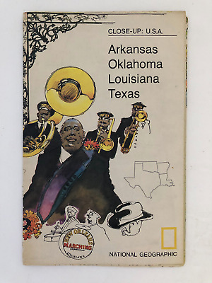
$5.49 Shipping Location: Georgetown, United States Template By Froo! National Geographic Map- 1974 Close-Up USA Oklahoma Texas Louisiana Arkansas National Geographic Map- 1974 Close-Up USA Oklahoma Texas ... moreLouisiana Arkansas Vintage 1974 two sided map Close-Up USA. Map shows Oklahoma, Louisiana, Arkansas, and Texas. The opposite side includes lots of historical information on the area by National Geographic Society. The map measures approx 35" x 23" in size. Never Unfolded. Shipping: All orders are carefully packaged. With a(Handle With Care Sticker) on the packaging. All orders ship the same or next business day. We ship orders Monday to Saturday. Orders placed before 2 pm(CST) on Fridays will ship on Saturday. We ship all orders via the United States Postal Service: First Class. Media Mail, Parcel Post, or Priority Mail, all include tracking numbers. Multi-Item Orders: We do combine shipping costs on multi-item orders. In order to receive the best shipping cost possible for your specific order please place your order. But before paying, request an invoice from us with combined shipping. We will return to you an adjusted invoice with the best shipping price for your order. Return Policy: Refunds given as money back or exchange(buyer’s choice) The buyer must pay return shipping. Please contact me within 14 days after receiving the item. Privacy Policy: Our company will never share your personal information in any way with an outside company. Our company will not send you unsolicited advertisements. Most reasonable offers are accepted. PayPal only. Please. Payment is expected within 2 days of auction end; immediate payment if you use Buy It Now. I will try and answer any questions. I am not an expert on anything I sell. And do my best to describe each item accurately. I buy many different items for the purpose of reselling them here on ebay. Any descriptions I give indicating the condition of item(s) such as: vintage. Antique, excellent, very good, good, and poor, or levels of functioning are purely subjective to what I observe, test and think of the item.
Buy It Now
Free Shipping Location: Schertz, United States This antique map from 1854 showcases the Indian Territory & the US states of Texas, Arkansas, Louisiana, and Mississippi. The lithography printing technique ... morewas used to create this beautifully hand-colored map. The map measures 9x11 inches and is in its original condition. It was published by Roswell C. Smith / Daniel Burgess & Co. The book cover is not available, and is only shown for reference purposes. This map is a perfect addition to any map collection, and is a great way to learn about the historical geography of the United States. Free shipping is available within the USA, and calculated shipping is available worldwide. Don't miss out on the opportunity to own this antique original map by Roswell C. Smith and Daniel Burgess & Co.
Buy It Now
Free Shipping Location: Monroeville, United States Date - 1885. Source - Harper’s School Geography Atlas. inventory # j74096. Condition - Very Nice.
Buy It Now
Free Shipping Location: Oakland, United States This map is regarded as the first printed map to feature the Florida peninsula when the territory was owned by the Spanish Empire areas of the New World. ... moreThis map probably had more influence than any other map in establishing the subsequent conception of Florida as including that part of the present U.S. from the peninsula of Florida northward to about 40° north latitude and westward to or beyond the Mississippi.".
Buy It Now
Free Shipping Location: Cochiti Lake, United States The French Connection in Texas 1686 - 1995. Drawn by artist and master cartographer Harvey Fletcher. 100 years before the American Revolution, Robert ... moreRene' Cavalier, Sieur de La Salle, French explorer, laid claim to what is now Texas soil...310 years of buried history is unearthed at Matagorda Bay, Texas. Shows Louisiana Purchase 1803. Historical detailed map. Very colorful map printed on parchment paper. Size 12" x 16".
Buy It Now
$4.99 Shipping Location: Fairview, United States (Title: 1) Galveston, Texas and its Fortifications. 2) Siege Operations against the Defenses of Charelston Harbor (Morris Island), July 10, 1863. 3) Port ... moreHudson and Vicinity, Louisiana. The title of the atlas appears in the top left margin and plate number in the upper right.
Buy It Now
Free Shipping Location: Anaheim, United States Typically that map at hand, the one being looked at, is in the center box. Scale: 1:100,000 (100K). feature within the bounds of the map, which frequently ... moreis a community, town, or city. The map covers a specific amount of area.
Buy It Now
$15.45 Shipping Location: Harrisburg, United States Colton’s hand-colored, double-sided map of (easter) Texas and Louisiana, Mississippi and Arkansas. A wonderful piece for framing.
Buy It Now
Free Shipping Location: North Wales, United States 1879 ANTIQUE GUYOT'S ATLAS MAP-SOUTHERN STATES-FLORIDA, LOUISIANA, TEXAS ORIGINAL ANTIQUE ATLAS MAP PLEASE SEE PHOTOS AS PART OF THE DESCRIPTION CONDITION: ... moreMAP IS IN GOOD CONDITION. SIZE: APPROXIMATELY 10" X 13" SHIPPING: U.S. FIRST CLASS RATE - $7.00 - ANY ITEM WHICH SELLS FOR OVER $100 WILL REQUIRE INSURANCE WE COMBINE SHIPPING FOR MULTIPLE WINS. THANK YOU FOR YOUR INTEREST IN OUR AUCTIONS!.
$16.00 Shipping Location: Poland Date of issue: 1782 (dated map). THIS IS AN ORIGINAL MAP, NOT A RECENT COPY OR REPRODUCTION. by Vaugondy R., engr. by Mounier S., publ. by Leroy A., Lyon ... more(France). HAND COLORED.
Buy It Now
$6.95 Shipping Location: Arlington, United States F. Cram's Unrivaled Atlas of the World. I will work hard to make sure you are satisfied and you can always start a case if you are not happy with my response.
Buy It Now
Free Shipping Location: Bedford, United States It is an antique map showing 1757 on it, is on a fragile tissue like paper.
Buy It Now
$6.95 Shipping Location: Dover, United States Issued 1867, New York by Charles Scribner. Map by Guyot. Mid 19th century lithographed map with original hand color.
Buy It Now
$3.50 Shipping Location: Dover, United States Year Published: 1958. Texas Point Quadrangle Louisiana-Texas 7.5 Minute Series. The map in the photo is the actual map you will receive. Water Bodies: ... moreMud Lake, Sabine Lake.
Buy It Now
$6.95 Shipping Location: Dover, United States Issued c. 1850's, New York by J. Bien.
Buy It Now
$6.95 Shipping Location: Dover, United States Issued 1867, New York by Charles Scribner & Sons. Map by A. Guyot. Mid 19th century engraved map with original hand color.
Buy It Now
$6.00 Shipping Location: Santa Barbara, United States This map series was printed between 1940 and 1948. The National Geographic Magazine. A. Hoen & Co. Lithographers, Baltimore U.S. A for The National Geographic ... moreSociety, Washington D.C. PICK UP OPTION.
Buy It Now
$10.00 Shipping Location: France You are bidding on an ORIGINAL 18th century map* Le Nouveau Mexique avec la partie septentrionale de l'Ancien ou de la Nouvelle Espagne. Rigobert ... moreBonne Naval engineer- Raynal- Atlas de toutes les parties connues du Globe terrestre- Copperplate engraving printed on one side only Paper Medium thickness and strong Color Recent hand coloring Inches 8 1/4 x 12 1/2. Cm 21 x 31.5. Plus margins Very good +. Title with light stains of original ink. Margins faintly soiled with minor tear to centrefold(top) Dark impression. Priority airmail. USA. Americas $6.00(approx. 7days) European Union $4.50(approx. 2/3 days) Optional registration $6.00. I will combine shipping for multiple purchases.RcmdId ViewItemDescV4,RlogId p4%60bo7%60jtb9%3Fvo%7B%3Dd70f%2Bf%60%60%3E-141def9cab7-0x104-
Buy It Now
Free Shipping Location: Riverside, United States Rare & Authentic Color Map. Condition: Minor yellowing due to age, NO TEARS. Exquisite Detail. . READY for FRAMING!
Buy It Now
$8.85 Shipping Location: Warwick, United States 1853 US Coast Survey ,AD Bache.This map shows Sabine Pass. Texas Point and Louisiana Point.It also shows other spots along the coast. A true antique. ... moreThis map has been mounted on linen cloth. It Is in very good condition. Please view all photos for condition.
Buy It Now
$4.69 Shipping Location: Greenacres, United States The map was engraved by E.F. Fisk and published by Hunt & Eaton inThe Peoples Cyclopedia of Universal Knowledge, New York, 1889.
Buy It Now
$8.78 Shipping Location: United Kingdom "Stielers Atlas of Modern Geography" by Adolf Stieler. Center fold as published. Antque Lithograph Map Published 1909 by Justus Perthes, Gotha for.
Buy It Now
$6.95 Shipping Location: Dover, United States Issued 1863, New York by Virtue Yorston & Co. Engraved by Rae Smith. Drawn by J. Wells. Scarce Civil War era color lithographed map.
Buy It Now
$5.95 Shipping Condition: New Location: Las Vegas, United States Year: 1747. Early Map of the Gulf Coast. “Vibrant and bright! Pic does not do it justice.looks amazing!”. Each of our prints are custom reproductions ... moreprinted on 68lb Heavyweight Enhanced Matte Art Paper.
Buy It Now
$4.13 Shipping Location: Canyon Country, United States This antique map depicts the chronological history of the Civil War battlefields that took place from 1861-1865.
Buy It Now
$4.15 Shipping Location: Saco, United States 11 7/8" x 9". This Map was Harvested from an 1854 Smith's Atlas of Modern and Ancient Georgraphy Book which was Published by Daniel Burgess & Co. Last ... more2 Photos will show the actual Atlas Cover and Title Page, neither are included and are only shown as Proof of Authenticity.
Buy It Now
$5.00 Shipping Location: Canada DATE OF ISSUE: 1912. ORIGIN OF THE MAP: "Stielers Handatlas", published in Gotha, Germany by Justus Perthes.
$16.00 Shipping Location: Poland Date of issue: 1865 (dated map). THIS IS AN ORIGINAL MAP, NOT A RECENT COPY OR REPRODUCTION. by Stulpnagel, publ. by Perthes Justus, Gotha (Germany). ... moreHAND COLOURED.
Buy It Now
$10.05 Shipping Location: Runnemede, United States Compiled and Drawn by Capt. S. Eastman USA 1852 Matted and in a protective plastic sleeve Engr. By W. Williams Phil. Lippincott, Grambo & Co. Phila. Condition ... moreis very good. Image size is approximately 8 x 11.25 (inches) Native American, American Indian Tribes. Western territories, Southwest US Ephemera for any history buff or cartographer
Buy It Now
$4.99 Shipping Location: Fairview, United States Stieler's Hand Atlas, published in Gotha by Justus Perthes. It is printed on a nice heavy page with bright color. Condition: The map is in Very Good to ... moreExcellent condition with a centerfold as issued, printed on a heavy paper.
Buy It Now
$33.88 Shipping Condition: Unspecified Location: LONDON, United Kingdom 'United States. Caption below picture:'United States. Antique atlas map with original hand colour, 1860. DATE PRINTED: 1860. Dallas is marked on the map; ... moreit had been incorporated as a city four years before publication of the map in 1856.
Buy It Now
$8.70 Shipping Location: Iron River, United States
Buy It Now
$8.70 Shipping Location: Iron River, United States
Buy It Now
$5.00 Shipping Location: Canada DATE OF ISSUE: 1936.
Buy It Now
$3.00 Shipping Location: Edwardsville, United States Bienville Parish Louisiana1908 for sale. Colors are bright. Bienville Parish Louisiana. 21 Bienville Parish Louisiana. 25 Camp County Texas. 23 Corpus ... moreChristi Texas. 27 Coffee County Tennessee. 26 Overton County Tennessee.
Buy It Now
Free Shipping Location: Carefree, United States SMALL INSET MAP AT LOWER LEFT OF ANNUAL PRECIPITATION.
Buy It Now
$8.70 Shipping Location: Iron River, United States
Buy It Now
$4.99 Shipping Location: Fairview, United States An Authentic Antique Map: Not a Modern Reproduction! Condition: It is in Very Good condition. There is another map on the reverse. The pics are of the ... moreactual map.
Buy It Now
$5.00 Shipping Location: Canada DATE OF ISSUE: 1938. ORIGIN OF THE MAP: "Der Neue Brockhaus" (Atlas), published by F. A. Brockhaus, Leipzig, Germany.
$16.00 Shipping Location: Poland Date of issue: 1843 (dated map). by du Bocage, engr. by G. Bonatti, publ. HAND COLORED. THIS IS AN ORIGINAL MAP, NOT A RECENT COPY OR REPRODUCTION.
Buy It Now
Free Shipping Location: Bremerton, United States The map shows typical natural aging and wear from use with a ragged edge where it was removed from the atlas. You could even use it as wrapping paper ... morefor a small gift.
Buy It Now
$6.95 Shipping Location: Dover, United States Issued 1852, Phila. by JH Young and 1869 by unknown.
Buy It Now
$14.99 Shipping Location: Ivanhoe, Australia Tirion, Isaac 1705 - 65. Date: - 1765. The US was engaged in its own Civil War (1861–65), so did not attempt to block the foreign intervention. First ... morepopulated more than 13,000 years ago, the territory had complex indigenous civilizations before being conquered and colonized by the Spanish in the 16th century.
|
|
|
In
|
Civil War Map Galveston Texas Port Hudson Louisiana Charleston Morris Island SC
Lake Erie Maps& Prints An Original Antique Map: Not a Reproduction! Plate XXXVIII Atlas to Accompany the Official Records of the Union and Confederate Armies Currently Listing Many Civil War Maps and Prints Check out my! Title: 1) Galveston. Texas and its Fortifications. 2) Siege Operations against the Defenses of Charelston Harbor(Morris Island) July 10, 1863. 3) Port Hudson and Vicinity, Louisiana. Description: It is an original antique folio page of southern harbors from the Atlas to Accompany the Official Records of the Union and Confederate Armies. Published by the Secretary of War, Washington: Government Printing Office, 1891-1895) undoubtedly the most complete set of accurate maps of the Civil War ever published. The title of the atlas appears in the top left margin and plate number in the upper right. A copy of the title page ... moreis included with all the publishing details for authenticity. The atlas was published in a very limited context to be distributed to government officials in the three houses of government as a reference for assessing the Civil War. This is from the original first publishing, that lasted from 1891-5. Size: The map image measures 16 by 27 inches on a page measuring approximately 18 by 29 inches with plenty of margin all around for framing. It is a full double page sheet as issued. Condition: The map is in Very Good condition with overall light tonal aging. Blank on the reverse, printed on heavy paper. There is some darkening around the edges, otherwise it is very clean and would frame up nicely. Pics are of the actual map. Payment Details: We accept most major credit cards through Paypal and Ebay. Please ask if you have any questions about payment. International and New Bidders are welcomed and encouraged. Payment is expected within 7 days. After which Nonpaying Bidders will be reported to Ebay to recoup our listing fees. Save on Shipping: We only charge one shipping fee based on the largest map or print with multiple items shipped along with it for no extra costs. Purchase 5 o
|
|
|
Civil War Maps - CAMPAIGN MAP OF TEXAS, LOUISIANA AND ARKANSAS BY J.P. BLESSINGT
This is an exquisite full-color Reproduction printed on heavyweight(7.0 MIL) Glossy Photo Paper. These maps are perfect for framing. Or a wonderful and unique gift for family members, friends or co-workers! All Information is Carefully Compiled from Actual Surveys Original Maps are often difficult to find and usually have fold lines. Identifying stamps or markings, tears, ragged edges, and assorted other natural signs of age that detract from their beauty. All of our maps have been professionally restored to depict their original beauty, while keeping all historical data intact. These maps are fabulous pieces of history full of information useful to Historians. Genealogists, Cartographers, Relic Hunters, Others. They make fascinating conversation pieces and splendid works of art for the home or office. This historic map captures history through ... morea unique perspective. Event maps are authentic records of battles fought throughout the history of American wars. Dating back to the French& Indian War and recorded through the eyes of the noble military men themselves. They would make an excellent addition to any history buff's collection. Map Size: 23.00 x 30.44 Site Specifics To This Map Are: Rio Grande City. Laredo, San Antonio, Kerrsville, Bandera, Castroville, Fort Clark, Burnet, Ft. Cobb, Fayetteville, Ft. Davis, Ft. Gibson, Saline, Van Buren, Briartown, Scullyville, Fort Smith, Denton, Tecatur, Watherford, Ft. Worth, Dallas, McKinney, Greenville, Mt. Pleasant, Dangerfield, Gilmer, Chilton, Waxahatchie, Athens, Palestine, Fairfield, Gatesville, Corsicana, Galveston, Houston, Columbus, Austin City, Lockhart, Bastrop, New Braunfels, San Marcos, Seguin, Goliad, Victoria, Beaumont, Orange, Sour Lake, Hardin, Woodville, Jasper, Newton, Lake Charles, Vermillionvilla, New Iberia, Franklin, Centreville, Iberville, Nacogdoches, San Augustine, Milam, Hineston, Alexandria, Pineville, Trinity, Harrisonburg, Mansfield, Marshall, Shreveport, Mt. Lebanon, Minden, Monroe, Lewisville, Camden, Monticello, Pleasant Ridge, Bent
|
|
|
North Texas Louisiana Arkansas topographical c.1895 antique folio Civil War map
North Texas Louisiana Arkansas topographical c.1895 antique folio Civil War map Atlas to Accompany the Official Records of the Union and Confederate Armies 1861-1865 Plate CLVIII(North Texas/ Louisiana) Etc. Issued Washington. D.C. 1891-95 by the US Government Printing Office. Printed by Julius Bien& Co. Lithographers, N.Y. Published under the direction of Daniel S. Lamont. Secretary of War. Originally issued in the"Atlas to Accompany the Official Records of the Union and Confederate Armies" Which was issued in parts to subscribers over a period of years, but is sometimes found bound up later into atlas volumes. This oversize and attractive lithographed 19th century sheet depicts in great detail the specific events and locations of the Civil War. Astoundingly detailed. With an emphasis upon precision and accuracy, attempting ... moreto capture visually and cartographically the regions and battles depicted. Unlike topographical maps or state maps of the era issued by most cartographers. The underlying premise of these Civil War maps was to depict the cartography as it specifically related to events of the Civil War. Thus, individual battles, small forts, troop movements, local rail lines, panoramic views, etc. are often rendered and explained with precision in a manner quite unique. Also, the very large format of the sheet allows for a level of detail which makes the map perfect for display or study by a Civil War buff, since the detail it contains is to be found almost no where else on this scale. In near VG. Mostly clean condition. Map displays numerous short minor edge-splits in the wide blank margins, all of which will disappear once the map is matted for display. Also some light minor age-wear- typical for maps of this era, and in no way offensive or severe. Overall a pleasing example of this interesting map. Which is well worthy of display. Elephant folio sheet measures c. 29 1/2" W x 18 1/2" H. 6489] Any defects along the sheet edges and in the margins may be seen in the photos. note: All ol
|
|
|
Texas Arkansas Louisiana Mississippi 1853 Burgess antique hand colored map
Texas Arkansas Louisiana Mississippi 1853 Burgess antique hand colored map United States: Texas. Arkansas, Mississippi, Louisiana and Indian Territory Issued 1853. New York by Burgess Fine original antique steel engraved map. Printed in the 19th century, on quality paper which retains its inherent structural flexibility and soundness. With original hand color. We notice three tall masted sailing ships within the Gulf of Mexico. Population of Texas is given as 213.000. In Fair to Good or better condition. The sheet is toned with light scattered spotting as well as some minor staining and slight wrinkling but the image is still overall very presentable and attractive[note: we grade very conservatively and always seek to disclose any noteworthy flaws] Text on verso as issued. The printed area remains visually pleasing. A nice impression of an ... moreinteresting antique USA map which will look nice when displayed. Sheet measures c. 11" H x 9" W. Printed area measures c. 10 1/8" H x 8 5/8" W. 30892] Any defects along the sheet edges and in the margins may be seen in the photos. note: All old sheets of printed paper possibly have short edge splits. Each sheet has existed for a very long time and has probably been handled repeatedly in the course of it's existence. It has a history unique to it as an object. Most of the time any edge splits are short. Minor, insignificant and have been closed- either long ago or more recently with small pieces of archival tape. Most often these splits are trivial and easy to overlook visually. Basically, they would not significantly affect the piece adversely. The item is offered as seen. Please look carefully and make your decision knowing this antique image is nice. But it is not in perfect"like new" condition. However, with whatever flaws it possesses, it remains entirely worthy of ownership and inclusion in any related collection. We feel it will prove very pleasing to its new owner. We stand behind everything we sell. Everything we offer is guaranteed to
|
|
|
Texas New Mexico Kansas Louisiana Arkansas 1882 antique color lithograph map
Texas New Mexico Kansas Louisiana Arkansas 1882 antique color lithograph map Vereenigde Staten van N.A. Zuidlijke Midden Staten) United States of North America Southern Central States) Issued 1882. Amsterdam by G.L. Funke Fine original antique color lithograph map. Printed in the late 19th century, on quality paper which retains its inherent structural flexibility and soundness. In near VG or better condition. Light minor age wear, some scattered foxing but overall very presentable and attractive[note: we grade very conservatively and always seek to disclose any noteworthy flaws] The printed area remains visually pleasing. A nice impression of an interesting antique map which will look nice when displayed. Sheet measures c. 71/4" H x 9 1/4" W. Printed area measures c. 6" H x 7 7/8" W. Original fold line as issued. 35212] ... moreAny defects along the sheet edges and in the margins may be seen in the photos. note: All old sheets of printed paper possibly have short edge splits. Each sheet has existed for a very long time and has probably been handled repeatedly in the course of it's existence. It has a history unique to it as an object. Most of the time any edge splits are short. Minor, insignificant and have been closed- either long ago or more recently with small pieces of archival tape. Most often these splits are trivial and easy to overlook visually. Basically, they would not significantly affect the piece adversely. The item is offered as seen. Please look carefully and make your decision knowing this antique image is nice. But it is not in perfect"like new" condition. However, with whatever flaws it possesses, it remains entirely worthy of ownership and inclusion in any related collection. We feel it will prove very pleasing to its new owner. We stand behind everything we sell. Everything we offer is guaranteed to be an authentic original antique item as described. We do not sell modern reproductions. Please visit our. We happily accept PayPal!
|
|
|
Texas & Louisiana Oil Gas Wells Railroad 1903 Map Hand Colored
Texas& Louisiana Oil Gas Wells Railroad 1903 Map Hand Colored OIL Original 1903 map"Petroleum fields of the Texas and Louisiana Gulf Coastal Plains" Hand colored. This 110 year old map is in very good condition, overall size 9' x 5 1/4' Purchase with confidence. We have been in the antique print, map, and document business since 1976 and guarantee our items as advertised. See additional photos below! To See More Photos/Scenes Powered by Click Here. Double your traffic. Get Vendio Gallery- Now FREE!
|
|
|
Texas Louisiana Arkansas Mississippi 1860 antique folio cerographic color map
Texas Louisiana Arkansas Mississippi 1860 antique folio cerographic color map LOUISIANA, MISSISSIPPI, ARKANSAS, AND PART OF TEXAS Issued Philadelphia. C. 1860. Fine original antique cerographic map. Made approximately 150 years ago. Printed in the mid-19th century, on quality paper which retains its inherent structural flexibility and soundness. Nicely detailed, with attractive original hand color. In good+ condition. Scattered light foxing and spotting as seen in scan, some light soiling and paper wrinkling[note: we grade very conservatively and always seek to disclose any noteworthy flaws] Much of Texas is shown. With dozens of counties, a sailing ship off the coast near Galveston. The printed area remains visually pleasing. A nice impression of an interesting and scarce map. Sheet measures c. 11 1/4" W x 12 1/2" H. Printed area ... moremeasures c. 9 3/4" W x 11 3/4" H. Folio sheet. 12463] Any defects along the sheet edges and in the margins may be seen in the photos. note: All old sheets of printed paper possibly have short edge splits. Each sheet has existed for a very long time and has probably been handled repeatedly in the course of it's existence. It has a history unique to it as an object. Most of the time any edge splits are short. Minor, insignificant and have been closed- either long ago or more recently with small pieces of archival tape. Most often these splits are trivial and easy to overlook visually. Basically, they would not significantly affect the piece adversely. The item is offered as seen. Please look carefully and make your decision knowing this antique image is nice. But it is not in perfect"like new" condition. However, with whatever flaws it possesses, it remains entirely worthy of ownership and inclusion in any related collection. We feel it will prove very pleasing to its new owner. We stand behind everything we sell. Everything we offer is guaranteed to be an authentic original antique item as described. We do not sell modern reproductions. Please visit our.
|
|
|
Indian Territory Louisiana Texas Arkansas 1889 Stieler antique map variant
Die Vereinigte Staaten von Amerika Issued 1889. Gotha Germany by Perthes for Stieler Fine antique engraved map. With original outline hand color. Printed in the late-19th century, on quality paper which retains its inherent structural flexibility and soundness. A beautifully engraved and very detailed map of this region. With a profusion of details and small towns not often seen. There are numerous variants of this particular detailed map. And close comparison between them would yield hours of interesting research. In near VG or better condition. Some light scattered foxing as typical[note: we grade very conservatively and always seek to disclose any noteworthy flaws] The printed area remains visually pleasing, a nice impression of an interesting map. Sheet measures c. 18 1/2" W x 15 1/8" H. Engraved area measures c. 15 7/8" ... moreW x 13" H. Folio. Original fold line as issued. 20044] Guaranteed Authentic! We do not sell modern reproductions. Condition All of our items are original antique pieces and it is important to keep in mind that many of them have been around for 100 years or more. Individual pieces may have seen many owners and been handled many times over the course of their existence and as a result each piece has developed a history of it's own. Short edge splits(often repaired with archival tape) Foxing, discoloration, etc. are all things to expect on items of this type. They rarely distract from the piece and often add to the overall character of the item. Keep in mind when you receive your item that you are not handling a modern copy, you are holding a piece of history, an item that has been around for a very long time and will, with proper care, be around for a long time to come. We try to note any significant flaws in the description, but less noticeable or common characteristics may not be mentioned. As we are a US based company all of our measurements are in Inches. If you need the size in Centimeters please multiply the supplied measurement by 2.53. Payment and Shipping We hap
|
|
|
1847 Map COLOR Texas TX Oklahoma OK Arkansas AR Louisiana LA Mississippi Atlas
United States Map Texas. Arkansas, Louisiana, Mississippi, Oklahoma 1847 click picture to enlarge click picture to enlarge For your consideration is this Original Color Map of The States of Texas(TX) Arkansas(AR) Louisiana(LA) Mississippi(MS) Indian Territory(Oklahoma, OK) from the year 1847. Map is in Excellent Condition without any rips or tears. Small stain on the outer border towards the bottom on the left-hand side. Which is visible in the photographs. Map includes: Counties Capitals Towns State Populations Railroads Canals Indian Tribes Rivers Etc. Map Measures 9-1/4" x 11-3/4" Please refer to the photographs for details. for more great items! click picture to enlarge click picture to enlarge click picture to enlarge click picture to enlarge click picture to enlarge click picture to enlarge After making a purchase. Or after ... morethe end of an auction, please send payment via Paypal within the next three days. After receiving a cleared payment. Your item will be packaged and shipped within the next 48 hours. If you purchase more than one item. Please wait until I send you an updated invoice with combined shipping. txzj pxzj7579 txzj1.RcmdId ViewItemDescV4,RlogId p4%60bo7%60jtb9%3Fvo%7B%3Dd70f%2Bf52%3E-13faab10791-0xfb-
|
|
|
1778 VAUGONDY MAP OF TEXAS LOUISIANA FLORIDA WEST INDIES CARIBBEAN COSTA RICA
NOUVELLE ESPAGNE. NOUVEAU MEXIQUE, ISLES ANTILLES. 1778 VAUGONDY MAP OF TEXAS LOUISIANA FLORIDA WEST INDIES CARIBBEAN COSTA RICA, This original antique map gives you an opportunity to examine in exquisite detail a piece of history. If you are interested in the past of this country and its people or have a desire to study where your family may have come from. Then this map gives you a rare look as the area was about 230 years ago. Once matted and framed, this map would make a perfect gift for a family member or friend they'll cherish forever. Origin of the map: Nouvel Atlas Portatif" Published in Paris, France by Robert de Vaugondy. Date of issue: 1778 Size: The sheet measures 15 3/4" x 10 1/2" 40 x 27 cm) The map image: 15 3/4" x 9 1/4" 40 x 23.5 cm) S/H: The map will be shipped by Air Mail. The shipping charge ... moreis: USA- 10.00. Canada- 10 USD. The price includes the insurance and a strong, cardboard tube with plastic plugs. Attention! There is no additional shipping charge for multiple purchases! Pay me securely with any major credit card through PayPal! Payment methods: US/Canada Buyers: Paypal. International Buyers: Paypal. Click Here. Double your traffic. Get Vendio Gallery- Now FREE! Lm3vhp.RcmdId ViewItemDescV4,RlogId p4%60bo7%60jtb9%3Fuk%601d72f%2Bjw%60%3Elm3vhp-1413c49e773-0xfd-
|
|
|
1757 LOUISIANA ALABAMA TEXAS Map J N BELLIN GEOGRAPHY ATLAS Original Antique!
An ORIGINAL antique 1757 French map of LOUISIANE from L'HISTOIRE GENERALE DES VOYAGES. J. N. BELLIN was the official engraver to the Marine at the time and produced a number of the maps published in L'HISTOIRE. Possibly the most accurate map of the region at the time it shows scores of settlements. Forts, and Indian Villages along the coast and inland of what is now the Southeast from the Atlantic Coast to west Texas. A number of Indian Tribes are named as well including the APACHES, CHICACHAS, TCHATAS, and CHERAQUIS. Note from the photos that the date 1757 is printed in the legend. Note also that the map has significant old damage from bookworm moths. The first 4 pictures are taken with a plain white background while the last picture is taken with a dark background to illustrate the damage. Otherwise the paper is still supple with ... moreno stains and the original plate impression around the entire periphery. This RARE and unusual map usually sells for multiples of the starting price if not for the above described damage. Map measures 10 by 13 inches and is perfect for matting and framing. The damage should appear minimal if mounted and framed with a white background. This ORIGINAL antique map is guaranteed over 250 years old. Published decades before the REVOLUTIONARY WAR. I do not sell reproductions, just honest maps at honest prices. Discounted shipping too. NO international shipping. NO exceptions. All items shipped within 2 business days after payment. If you have not received an item in a reasonable amount of time please email me. It has been delayed by the Post Office. I also accept returns on ANY item for ANY reason, please email me I am very easy to work with. Feedback is not the same thing as an email, please email first. On Oct-19-07 at 13:06:06 PDT. Seller added the following information:
|
|
|
Texas Louisiana Arkansas Indian Territory United States 1890 Map Gulf Of Mexico
Texas Louisiana Arkansas Indian Territory United States 1890 Map Gulf Of Mexico U.S. Original 1890 map"United States" minor age spot in Gulf area otherwise good condition. Overall size 10 1/2' x 8' Purchase with confidence. We have been in the antique print, map, and document business since 1976 and guarantee our items as advertised. See additional photos below! The black circles that show in some of the listings are magnets that we use to hold image. To See More Photos/Scenes Powered by Click Here. Double your traffic. Get Vendio Gallery- Now FREE!
|
|
|
Antique 1892 East Texas Large 20X13 Wall Map. E TX. Louisiana LA, Mississippi MS
Combined shipping is offered to US buyers in the shopping cart. Just use the blue" Add to Cart" button located by the price. Just pay the highest priced shipping of one item and all others ship at no extra postage charge if you Paypal in ONE transaction and all ship in the same envelope. Not a reproduction or copy. Large original antique multicolor 121 year old double page map of East Texas. Continuous seam. Sheet measures 21.25" x 14.5" The actual map in the borders is 20.25" x 13.25" This was sourced from a 19th century atlas with a copyright date of 1892. On the other side is a one page map of Louisiana. 12.5" x 10" map size. The other back page is Mississippi. 13" x 10.125" Overall VG. These maps have some very minor spots. The worst one over Fayette Co. Texas near the centerfold. photo ... more5) Zoom to inspect. Also listed is the West Texas Map. Combine these for a huge wall display. The colors are undiminished by its age and can best be described as non sheen. Shipped flat with cardboard along the as issued existing folds. Indiana residents add 7% sales tax. Returns only for listing errors. The photos are part of the description.
|
|
|
1779 Bonne Map Mexico Texas Louisiana Baja United States Santa Fe San Antonio
Lake Erie Maps& Prints! An Original Antique Map: Not a Reproduction! See Our Ebay Store for other! Free US Shipping on Purchases of 5 or More Maps and Prints Description: It is an original antique copper engraved map with embossed plate marks in the margins. It is by M. Monsieur] Rigobert Bonne for Guillaume Reynal's Atlas de toutes les parties connues du globe terrestre. Published around 1779. A facsimile copy of the title page is included. Rigobert Bonne(1729-1795) was the Royal Hydrogapher. Making maps for the King of France succeeding Nicolas Bellin in 1773. Bonne's name appears in the title area of the map as M. Bonne. Ingenieur Hydrographer de la Marine. The map is not mounted nor matted. Being sold as a single sheet as seen in the first pic. Size: The map image measures approximately 8 1/2 by 12 1/2 inches(22x32cm)on a ... more10 by 14" page(25x35cm) with a margin all around as seen in the pic. Condition: The map is in Good condition for its age. Printed on laid cotton rag paper, blank on the reverse with a centerfold as issued. It is basically as seen in the pics. There is some darkening around the edges, otherwise it is clean with a strong impression and antique patina that would frame up well. The pics are of the actual map. Payment Details: We accept most major credit cards through Paypal and Ebay. Please ask if you have any questions about payment. International and New Bidders are welcomed and encouraged. Payment is expected within 7 days. After which Nonpaying Bidders will be reported to Ebay to recoup our listing fees. Save on Shipping: We only charge one shipping fee based on the largest map or print with multiple items shipped along with it for no extra costs. Purchase 5 or more maps or prints and receive Free First Class shipping in USA or First Class International elsewhere in the world. Although registration may be required on shipments of high value. Shipping: Russia. Brazil and other uninsurable countries add $12 for Registered Mail plus cost of shipping. International Customs and V
|
|
|
National Geographic Map - 1974 Close-Up USA Oklahoma Texas Louisiana Arkansas
Template By Froo! National Geographic Map- 1974 Close-Up USA Oklahoma Texas Louisiana Arkansas National Geographic Map- 1974 Close-Up USA Oklahoma Texas Louisiana Arkansas Vintage 1974 two sided map Close-Up USA. Map shows Oklahoma, Louisiana, Arkansas, and Texas. The opposite side includes lots of historical information on the area by National Geographic Society. The map measures approx 35" x 23" in size. Never Unfolded. Shipping: All orders are carefully packaged. With a(Handle With Care Sticker) on the packaging. All orders ship the same or next business day. We ship orders Monday to Saturday. Orders placed before 2 pm(CST) on Fridays will ship on Saturday. We ship all orders via the United States Postal Service: First Class. Media Mail, Parcel Post, or Priority Mail, all include tracking numbers. Multi-Item Orders: We do combine ... moreshipping costs on multi-item orders. In order to receive the best shipping cost possible for your specific order please place your order. But before paying, request an invoice from us with combined shipping. We will return to you an adjusted invoice with the best shipping price for your order. Return Policy: Refunds given as money back or exchange(buyer’s choice) The buyer must pay return shipping. Please contact me within 14 days after receiving the item. Privacy Policy: Our company will never share your personal information in any way with an outside company. Our company will not send you unsolicited advertisements. Most reasonable offers are accepted. PayPal only. Please. Payment is expected within 2 days of auction end; immediate payment if you use Buy It Now. I will try and answer any questions. I am not an expert on anything I sell. And do my best to describe each item accurately. I buy many different items for the purpose of reselling them here on ebay. Any descriptions I give indicating the condition of item(s) such as: vintage. Antique, excellent, very good, good, and poor, or levels of functioning are purely subjective to what I observe, test and think of the item.
|
|
|
1888 TEXAS INDIAN TERRITORY ARKANSAS LOUISIANA HAND COLOR MITCHELL MAP ORIGINAL
ORIGINAL. NOT A COPY NOR A REPRINT, HAND COLORED MAP OF TEXAS, INDIAN TERRITORY, ARKANSAS AND LOUISIANA; DATED 1888 BY MITCHELL; 9.75" X 12" FROM MITCHELL'S INTERMEDIATE GEOGRAPHY; MARGIN TEAR, ARCHIVAL MENDED ON BACK-NOT IN MAP AREA; O/W VERY GOOD CONDITION AND WOULD FRAME UP WELL-SEE PHOTOS. CHECK OUT MY OTHER EARLY ADS, HISTORIC AND SPORT ITEMS. 1?RcmdId ViewItemDescV4,RlogId p4%60bo7%60jtb9%3Feog4d72f%2B%3E%3B1%3F-14523685e95-0x118-
|
|
|
Original 1853 Coast Survey Map SABINE PASS Proposed Lighthouse Texas Louisiana
Original 1853 Coast Survey Map SABINE PASS Proposed Lighthouse Texas Louisiana Original antique lithographed United States Coast Survey reconnoissance map of Sabine Pass. Printed more than 160 years ago. The image area measures 28 x 22 cm[11" x 8-3/4" And the map is drawn on a scale of 1:40,000. It shows soundings and bottom conditions and gives sailing directions for approaching mariners. It locates a proposed site for a lighthouse. On the Texas side of the Sabine River, but the light was built, in 1856 on the Louisiana side, across from the present location of the town of Sabine Pass, Texas. This map was published in Report of the Superintendent of the Coast Survey. Showing the Progress of the Survey during the Year 1853. Printed by Robert Armstrong, Washington, D.C. in 1854. Condition: It is in very good condition. With two folds, ... moreas issued, and no marks. Rips, or tears. It is printed on a lightweight paper, typical of mid-19th century government publications, and it is blank on the back, with no printing on the reverse side. The scan below gives a closer look at the title area: Buy with confidence! We will ship your map carefully rolled in a sturdy cardboard tube. We are pleased to offer it with our unconditional. Money-back guarantee. SHIPPING: We gladly ship anywhere in the World. And we use sturdy, professional packing materials to assure safe delivery. The shipping charges are as follows: Within the United States. Including Alaska, Hawaii, and APO addresses: $4.59 To Canada or Mexico: $9.99 To all other international destinations: $14.29(These charges reflect recent increases made by the United States Postal Service for international delivery. We will appreciate your prompt payment for this item. If you need more time or have any other questions about making your payment. Or if you may desire any special services, such as overnight delivery, please contact us. Florida residents add 6.5% sales tax. Be sure to check our auction listings on eBay for other antique and collectible maps and ephemera.
|
|
|
1886 TEXAS INDIAN TERRITORY ARKANSAS LOUISIANA AND NEW MEXICO ORIGINAL MAP
ORIGINAL 1886 MAP SHOWING THE AREAS AFFECTED BY SOUTHERN CATTLE FEVER TEXAS. NEW MEXICO, LOUISIANA, ARKANSAS AND INDIAN TERRITORY DATE 1886. NOT ON MAP PUBLISHED BY UNITED STATES DEPARTMENT OF AGRICULTURE FROM CONSULAR REPORT OF 1885 COMMISSIONER OF AGRICULTURE MAP SHOWS AREAS AFFECTED BY THE SOUTHERN CATTLE FEVER OUTBREAK IN THE 1880'S. MAP ALSO SHOWS COUNTIES AS WELL AS A FEW TOWNSHIPS. MEASURES 8.5 X 13 INCHES GOOD CONDITION WITH CREASES AS ISSUED
|
|
|
Rare 1869 Mitchell's Copper-Plate Map of Texas, Louisiana & Arkansas
Rare 1869 Mitchell's Copper-Plate Map of Texas. Louisiana& Arkansas. Hand Colored& Guaranteed original. Measures 12" by 9.5" A rare old map in surprisingly good condition that will look great matted& framed. See photo's. Free Shipping to anywhere in the US. Your order will always ship within ONE BUSINESS DAY. Well packaged in a sturdy waterproof mailer and sent with a delivery confirmation. I ship worldwide.
|
|
|
Texas Louisiana Oil Gas Field 1917 Map Hand Color Spindletop Matagorda
Texas Louisiana Oil Gas Field 1917 Map Hand Color Spindletop Matagorda OIL-GAS FIELD Original 1917"Index map of a part of the gulf coastal plain showing the location of the productive oil fields and the locations and in part the extent of the sabine uplift" hand colored. This 93 year old map features the locations of oil and gas fields n coastal texas and Louisiana. Folds as issued. Good condition overall size 9" x 8 1/2" 100% MONEY BACK GUARANTEE. If you are not pleased with your purchase for any reason. Contact us within 14 days of receipt, and we will refund 100% of your purchase price upon return of the item. We have been a leader in the historical print, and map business since 1976. We strive to build repeat and satisfied clients. To See More Maps
|
|
|
1872 TEXAS ARKANSAS LOUISIANA Atlas Map MITCHELL CIVIL WAR ERA Original!
An ORIGINAL antique map of TEXAS ARKANSAS and LOUISIANA from Mitchell's New Intermediate Geography Atlas. 1872. What 7 years earlier had been the western edge of the Confederacy, the States are individually hand water colored. A few early railroads are shown and a few proposed routes extend into west TEXAS. But as yet no railroads had been completed west of Austin. In fact western TEXAS is still shown as the territory of the APACHES, COMANCHES, and KIOWAYS. The map measures 9 1/2 by 12 inches. This ORIGINAL antique map is guaranteed over 140 years old published just after the end of the Civil War. I do not sell reproductions. Just honest maps at honest prices. Discounted shipping too. All items shipped within 2 business days after payment. If you have not received an item in a reasonable amount of time please email me. It has been delayed ... moreby the Post Office. I also accept returns on ANY item for ANY reason, please email me I am very easy to work with. Feedback is not the same thing as an email, please email first. On Oct-19-07 at 13:06:06 PDT. Seller added the following information:
|
|
|
1890's Vintage CIVIL WAR MAP: plate CLVIII Gen Topo part of TEXAS, LOUISIANA
thanks for checking out one of my items. If you like this you will probably like other items i have, i get tons of stuff in diverse fields of collecting and use. NOTE: i will always combine items to save you shipping cost. THIS ITEM IS-YOU ARE CONSIDERING THE MAP SHOWN IN THE PICTURES. IT IS APROX 18 X 29 inches(look at the photo for exact size) it may have some light wear and tear, again look at and zoom in on the photos, some are better than others) since they came from a book, they all have folds in the center and will be shipped, folded, between stiff cardboard and will arrive to you in the same condition they leave me. you only have to pay for shipping one time, no matter how many of these you buy. THIS one is PLATE CLVIII General Topographical Map sheet XXIII and shows: part of TEXAS, Louisiana and Arkansas a nice map from the ATLAS ... moreto Accompany the Official Records of the Union and Confederate Armies 1861-1865. the book this comes from was published by the Government Printing Office, Washington(1891-95) under the direction of the Hon. Redfeld Proctor, Secretary of War, by Major George B. Davis, U.S.A. Mr. Leslie J. Perry, Mr. Joseph W. Kirkley, Board of Publication. Compiled by Capt. Calvin D. Cowles, 23rd U.S. Infantry. I HAVE NOTICED ON EBAY THAT SOME PEOPLE TRY TO SELL THESE MAPS AS COMING FROM 1865. THAT IS NOT TRUE, THEY ARE FROM THE 1890'S. i have aquired aprox 100 of the 175 maps that came from this 2 volume set. it is very hard to find and the complete set sells for 4000-7000. the individual maps sell for 65-400 depending on which map it is, they are hard to find, i think there were only around 2000 copies of the book made. Note: i can ship many of these for the same shipping cost. As the weight is from protecting the map, not the map itself. TERMS AND CONDITIONS 1. Paypal users must be verified. And have a confirmed address. 2. Payment must be received within 5 days. Or sale is voided, and item may be relisted. 3.Shipping is usually done by USPS or Fed Ex. I may switch shipping carrier
|
|
|
Original Pre-Civil War 1855 Antique Hand-Colored Map TEXAS LOUISIANA ARKANSAS
Fine Adornment of Texas. Louisiana, Arkansas History. Impressive on Any Home or Office Wall. Great for Genealogy. Imaginative& Creative Gift. 1855 Map of Arkansas. Louisiana, Texas Fine S.S. Cornell Map. J. Wells Engraved. Original 1855. 160-ys-old. Map is in Very Good/Good condition: No writings or marks. Mild foxing. Nominal to moderate fraying. Not a Reproduction. Original Map Engraved by J. Wells for the 1855 Edition of Cornell's Intermediate Geography. Forming Part Second of a Systematic Series of Geography, by S.S. Cornell, of the American Geographical Society; Published 1855 by D. Appleton& Company, 443& 445 Broadway, New York, 1855; a Copy of the Title Page of which is Included. A Fine Map for the Collector or Makes Quite An Impressionable Gift. I Sell Only Original Maps: No copies or reproductions Press Here to View ... moreMy Collection. Impressive On Any Home or Office Wall. Dimensions: 9" x 11" Intricate Detail. S.S. Cornell Map. Hand-Colored. Great for Family History/Genealogy as Map Shows Towns& Landmarks of 1855. Some of which No Longer Exist Today. Imaginative& Creative Gift. The Auction is for the Map Itself. A Frame is Not Included. The Framed Map Pictured is a Personal 1857 Map Featured to Show the Beauty of the Maps when Framed. Free Shipping Special. All Credit Cards. Debit Cards, and Electronic Checks accepted through Paypal. Maps are mailed within 1-3 days of payment and normally arrive within 3-5 days. Please email with any questions. Greetings from Historical Savannah. Georgia; founded 1733. Some. To beautify their halls, parlors, chambers, or libraries.loveth, getteth, and useth maps, charts, geographical globes. John Dee. Advisor to Elizabeth I. Press The Store Link Below To View My Collection. Powered by The free listing tool. List your items fast and easy and manage your active items. 3c0.RcmdId ViewItemDescV4,RlogId p4%60bo7%60jtb9%3Feog4d71f%2B%3E3c0-14a4c8c61b7-0x103-
|
|
|
Western Coast of LOUISIANA & of NEW LEON (TEXAS) 1981 REPRINT Texas Hist. Assoc.
The Western Coast of Louisiana and the Coast of New Leon. 1775 Page size: 19.50" x 15.25" Reprinted by The Texas State Historical Association in 1981. Historically fascinating& important 18thc. map of Texas coast. inaccuracies& all. A pinhole on each upper corner and 1-2 very light smudges. Overall very good. Buy with confidence. we have 100% positive feedback. SOLD AS SEEN. SOLD AS IS. All sales final. Shipping coast for U.S. only. International okay. Payment due within 2 days of purchase. See our OTHER antique map AUCTIONS& EBAY STORE.
|
|
|
Texas Arkansas Mississippi Louisiana Indian Ter. 1855 antique hand color map
Map No. 6 United States(Texas- Louisiana- Mississippi- Arkansas- Indian Territory) Printed 1855. New York by Daniel Burgess& co. Nice old map with original hand color. A map which could readily be collected on it's own merits. Displayed or given as a present. In Good+ or better antiquarian condition. Mostly clean overall, light minor age dustiness or light surface wear, small scattered spotting or age soiling as seen. Please inspect enlargeable photo closely- any noteworthy flaws to the printed surface area should be noticeable within zoomable picture provided. This scan forms a central part of the item description and we encourage you to study it carefully. We will send the actual antique item shown. note: We grade very conservatively. We are doing our best to show& describe this item so you are happy when it arrives] An interesting ... moreantique printed map that any collector. Dealer, institution or person of taste would be happy to own or display. Sheet measures c. 9 1/4" W x 11 1/2" H. Engraved area measures c. 8 1/2" W x 10 3/8" H. 85097] Everything we offer is guaranteed to be an authentic original antique item as described. We stand behind everything we sell. Important information for International Buyers* You may be charged customs. Taxes or other import duties by your country! this has nothing at all to do with us. Please do not hold us responsible if your Government wants to collect tax when you buy something outside of your country] Import duties. Taxes, and customs fees are not included in the item price or shipping cost. These charges are normally collected by the shipping service when the package is delivered or when you pick the item up. They are the buyer's responsibility and are not additional shipping charges. Please understand they have nothing to do with us and we have no control over them] Please check with your country's customs office to determine what these additional costs will be prior to bidding or buying. We do not know the various rules of your Custom
|
|
|
Rare Antique 1878 Mitchell's Map TEXAS Louisiana & Arkansas Genuine Hand Color
Rare Antique 1878 Mitchell's Map of TEXAS Louisiana& Arkansas Genuine Original Hand Water Colored Up for bid is this amazing rare original Mitchell's 1878 antique map of Texas. Louisiana& Arkansas. 100% authentic. Hand water colored in the 1870's. Measures approximately: 12" x 9 1/2" An incredibly gorgeous genuine antique map. More pictures below. Get it while you can! for more great items! Once you win an auction or purchase and item. Please pay as soon as possible. In the event that you are not able to pay right away. I give you a full 4 days to make payment. Timely payment is very much appreciated. Thanks! I ship Worldwide via USPS Priority Mail and First Class Mail and charge only the actual shipping cost(no handling fees) I will always combine shipping whenever possible to save you money. I ship Monday- ... moreFriday(not Saturday. Sorry) and usually ship within 24 hours of receiving payment. txzj pxzj19251 txzj1
|
|
|
LARGE ANTIQUE 1893 TEXAS MAP RAILROAD DETAILED & NEW ORLEANS LOUISIANA RARE NR
Click Here. Double your traffic. Get Vendio Gallery- Now FREE! Very fine. Antique 1893 color lithographed map. The map is 4 pages and any side would frame and display quite nicely, the first page is New Orleans, with Steam Railroads and Horse Railroads chart, corresponding to the map itself, the next 2 pages is a large and fine map titled Texas, also nicely detailed, with the railroads the last page is Kentucky and Tennessee. The map is from the very rare 1893 Wanamaker Atlas of the World. Very nicely color lithographed period map, printed on fine paper. The size of the single page map is 12" by 13.5" and the 2 page map is 13.5" by 24" Rare. Winning bidder pays $3.50 shipping domestic, more foreign. Payment I accept the following forms of payment: PayPal Click to View Image Album Click to View Image Album Click to View ... moreImage Album Shipping& Handling US Shipping. $3.50 USPS First-Class Mail® International Shipping. $11.50 USPS First-Class Mail International FREE scheduling. Supersized images and templates. Get Vendio Sales Manager. FREE scheduling. Supersized images and templates. Get Vendio Sales Manager.
|
|
|
Texas Louisiana Indian Territory Antique Colored Map 1887
Texas. On verso Louisiana& Indian Territory Large Map of Texas. Louisiana on verso of first panel, Indian Territory on verso of second panel. by Cram Issued 1887. Chicago, published by Henry S. Stebbins In VG condition or or better. Minor soiling, trivial spotting or foxing, well worthy of hanging for display. Open Sheet measures c. 11" x 21 1/2" Each Panel measures c. 11" x 13 1/2" Click Image For Larger Picture Scroll down for 4 more pictures below! We do not sell modern printings or modern reproductions. All of our maps and prints are genuine vintage or antique which will make great additions to a portfolio or look attractive on hanging on your restaurant. Store, office or home wall. Please see the photos or scans embedded in this description to inspect the individual item. To see a higher resolution version of ... morethe image. Click on the image. We do not use stock photos, these are the images of the item you will receive. As with all old paper, there will be imperfections such as foxing, age toning, staining, splits, uneven edging and possibly unrelated printing on the back side. We strive to capture these details within the photos. Should you have any questions about a print or map you are interested in, please do not hesitate to ask. Most old maps and prints were originally issued in a bound form. We do not actively“break” books and atlases for prints and maps. Especially books in the very good to fine condition where market value would deter this. Only on the rare occasion where a book is in poor condition and has lost desirability due to low shelf appeal but the contents are still in good condition and worthy of preservation. Most of our prints and maps are obtained loose from collections and in larger batches. Keep in mind. You can return the item within 14 days, hassle free. The only thing we ask is that the item is returned within the same condition it was sent. All Items are shipped in quality materials and packed with care. Smaller items are stored in archival grade bags and board
|
|
|
1853 U.S Coast Survey Map, Nautical Sketch, SABINE PASS, Texas / Louisiana, Gulf
Antique Black& White Map/Sketch Area: Sabine Pass- Texas/Louisiana Source/Date: U.S. Coast Survey. 1853 Size: 10.25" x 12.25" Approximate measurement of the largest dimensions. You may wish to trim uneven edges/margins) Condition: This is not a copy. Please zoom-in on all photos to see specific condition details ~~ Please be sure to check out my! I'm listing many more Antique Maps& Prints. Shipping is just $0.50 more for each additional map ~~ Thanks for looking at this listing! Payment and Shipping Info: Payment can be made through PayPal or Cash upon Pickup. Please send me a message regarding other options. New York State residents will be charged 8% Sales Tax. International Buyers: If you don't see a shipping price for your country please ask before purchasing. I may be able to add shipping options for you. But ... moresome items I do not ship internationally. Also, you are responsible for import/customs/duty fees incurred. I declare the actual price on the customs form, please don't ask me to lower it. I almost always ship within 1 business day! Free Tracking on all US orders. I'm happy to combine shipping when possible. When purchasing more than one item just wait for an invoice that will reflect combined shipping savings. If you'd like a quote ahead of time feel free to contact me. Additional Info: Your satisfaction is extremely important to me. Once you receive your item/s and are happy with them I hope you will consider leaving me positive feedback. As I will be doing the same for you. If you are not satisfied with your item please contact me immediately to arrange for a return/refund. Thank you for your interest. And please don't hesitate to contact me with any questions!
|
|
 |