-
Christian Collectibles
-
Christian Sheet Music
-
Vatican Stamps
-
Vatican Coins & Paper Money
-
Antiques
-
Antiquities
-
Architectural & Garden
-
Decorative Arts
-
Ethnographic
-
Furniture
-
Maps, Atlases & Globes
-
United States (Pre-1900)
-
AK, HI
-
AL, FL, GA, MS, NC, SC
-
AR, IA, KS, LA, MO, NE
-
AZ, CA, CO, NM, NV, UT
-
CT, MA, ME, NH, RI, VT
-
DC, DE, MD, NJ, NY, PA
-
ID, OR, WA
-
IL, IN, MI, OH, WI
-
MN, MT, ND, SD, WY
-
OK, TX
-
VA, WV, KY, TN
-
Entire US
-
United States (1900-Now)
-
United States (Date Unknown)
-
Africa
-
Asia
-
Australasia/ Oceania
-
Canada
-
Central America/ Caribbean
-
Europe
-
India
-
Ireland
-
Mexico
-
Middle East
-
North America
-
South America
-
United Kingdom
-
Maps on CD
-
World Maps
-
Globes
-
Mixed Lots
-
Reproductions
-
Price Guides & Publications
-
Other
|
In
Order by: Available to: This site contains affiliate links for which I may be compensated
|
$6.00 Shipping Location: Corunna, United States This map is from A New General Atlas Exhibiting The Five Great Divisions of the Globe drawn and engraved by M. Malte-Brun. Atlas was published by Grigg ... more& Elliot Philadelphia 1832. This is an original 192 year old map, not a copy or reprint.
Buy It Now
Free Shipping Location: Easton, United States [Smith, Roswell C.], Louisiana, Mississippi, Arkansas and Part of Texas.
Free Shipping Location: Schertz, United States This piece was removed from an 1863 JOHNSON ATLAS and is in good condition. The map is not " new " or in " new " condition, it was printed in 1863. The ... moremap is not dated. Study the photos carefully, this is the actual map you will receive.
Buy It Now
Free Shipping Location: Carefree, United States RARE ORIGINAL ANTIQUE 1852 MAP OF PART OF THE SOUTHERN STATES. AMAZING AND VERY DETAILED PRE-CIVIL WAR MAP OF THE SOUTHERN STATES. RARE ORIGINAL ANTIQUE ... more1852 MITCHELL MAP OF OF THE SOUTHERN STATES. FAIR GOOD CONDITION, CENTER FOLDING AS ISSUED, DISCOLORATION AND STAINING, TEAR AT TOP CENTER FOLD/CREASE.
$4.85 Shipping Location: Taylor, United States Great collectible great for framing map has been folded looks like tape on the back, where it is folded, some minor discoloration fading I will be mailing ... morethe map folded. On back is population of three states by counties United States, national census, 1890 some minor rips on edges of map
Buy It Now
$4.55 Shipping Location: Oakland, United States Enhance your antique collection with this stunning multicolor map of Tennessee, Alabama, Mississippi, Louisiana, and Arkansas. Printed in 1885, this rare ... morepiece showcases the topography, cities, and borders of these states. Whether you're a history enthusiast or a map collector, this antique gem is a must-have for your collection.This intricately detailed map is not only a beautiful display piece but also a valuable educational tool for students and scholars. Its vintage charm and unique aesthetic make it a conversation starter in any room. Don't miss the chance to own this one-of-a-kind antique map.
Buy It Now
Free Shipping Location: Sayville, United States Original 1891 Map of Arkansas. Louisiana& Mississippi by Hunt& Eaton. Shows counties, major cities and railroad lines. On the rear are population ... moretables of each county taken from the 1890 census. Measures approximately 13.37" by 11" A vintage lithograph that will look great matted and framed. See photo's. Free Shipping to anywhere in the US. Your order will always ship within ONE BUSINESS DAY. Well packaged in a sturdy waterproof mailer and sent with a delivery confirmatio n. I ship worldwide. Froo www.froo.com | Froo Cross Sell. Free Cross Sell, Cross promote, eBay Marketing, eBay listing Apps, eBay Apps, eBay Application. RcmdId ViewItemDescV4,RlogId p4%60bo7%60jtb9%3Fuk%601d72f%2Bfg2%3E-1485b114aa9-0x10d-
Buy It Now
$3.65 Shipping Location: United States The size of the map is 11.5" by 13". More than just a pretty picture. Over 100,000,000 served. FREE scheduling, supersized images.
Buy It Now
Free Shipping Location: Savannah, United States Original Antique 142-year-old Map of Louisiana Mississippi and Arkansas Drawn and Engraved for the 1882 Edition of The People's Cyclopedia of Universal ... moreKnowledge: A Compendium of Appendixes Invaluable for Reference in All Departments the Arts and Life, the Whole Brought Down to the Year 1882, with Pronunciation Conformed to Webster's Unabridged Dictionary, Illustrated with Over Five Thousand Engravings and Over One Hundred Color Maps of Each State and Territory of the United States, including City Maps, Continents, the World, and Every Country Across the Globe. Great for American History and Family Genealogy. Imaginative and Creative Gift. Fine Map for the Collector or Historian. Easily Framed.
Buy It Now
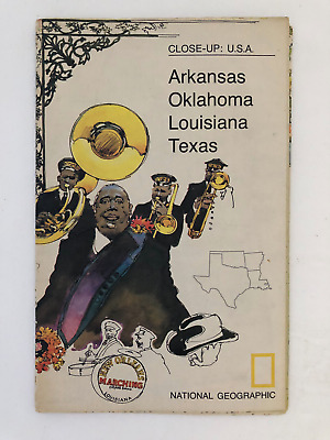
$5.49 Shipping Location: Georgetown, United States Template By Froo! National Geographic Map- 1974 Close-Up USA Oklahoma Texas Louisiana Arkansas National Geographic Map- 1974 Close-Up USA Oklahoma Texas ... moreLouisiana Arkansas Vintage 1974 two sided map Close-Up USA. Map shows Oklahoma, Louisiana, Arkansas, and Texas. The opposite side includes lots of historical information on the area by National Geographic Society. The map measures approx 35" x 23" in size. Never Unfolded. Shipping: All orders are carefully packaged. With a(Handle With Care Sticker) on the packaging. All orders ship the same or next business day. We ship orders Monday to Saturday. Orders placed before 2 pm(CST) on Fridays will ship on Saturday. We ship all orders via the United States Postal Service: First Class. Media Mail, Parcel Post, or Priority Mail, all include tracking numbers. Multi-Item Orders: We do combine shipping costs on multi-item orders. In order to receive the best shipping cost possible for your specific order please place your order. But before paying, request an invoice from us with combined shipping. We will return to you an adjusted invoice with the best shipping price for your order. Return Policy: Refunds given as money back or exchange(buyer’s choice) The buyer must pay return shipping. Please contact me within 14 days after receiving the item. Privacy Policy: Our company will never share your personal information in any way with an outside company. Our company will not send you unsolicited advertisements. Most reasonable offers are accepted. PayPal only. Please. Payment is expected within 2 days of auction end; immediate payment if you use Buy It Now. I will try and answer any questions. I am not an expert on anything I sell. And do my best to describe each item accurately. I buy many different items for the purpose of reselling them here on ebay. Any descriptions I give indicating the condition of item(s) such as: vintage. Antique, excellent, very good, good, and poor, or levels of functioning are purely subjective to what I observe, test and think of the item.
Buy It Now
$4.95 Shipping Location: Bar Harbor, United States This map is from "Hammond's Handy Atlas of the World with new Census 1915. Original Antique Hammond Map. (atlas and title page are not part of sale). ... moreand on reverse. Image Size: 5.0" x 7.0" (12.6 cm x 17.6 cm).
Buy It Now
$4.55 Shipping Location: Oakland, United States This antique map from 1873 showcases Mississippi, Louisiana, and Arkansas in intricate detail. The map measures 12x10 inches and is a great addition to ... moreany collection of antique maps. The map accurately depicts the geography of the three states, including rivers, cities, and topography. This piece is perfect for history enthusiasts and collectors alike.
Buy It Now
$5.00 Shipping Location: North Wales, United States 1868 ANTIQUE COLTON ATLAS MAP-MISSISSIPPI, LOUISIANA, ARKANSAS-UNITED STATES ORIGINAL ANTIQUE ATLAS MAP PLEASE SEE PHOTOS AS PART OF THE DESCRIPTION CONDITION: ... moreMAP IS IN GOOD CONDITION. SIZE: APPROXIMATELY 7.5" X 9.5" SHIPPING: U.S. FIRST CLASS RATE - $6.00 - ANY ITEM WHICH SELLS FOR OVER $100 WILL REQUIRE INSURANCE WE COMBINE SHIPPING FOR MULTIPLE WINS. THANK YOU FOR YOUR INTEREST IN OUR AUCTIONS!.
Buy It Now
$6.95 Shipping Location: Dover, United States Die Staaten von Arkansas, Mississippi, Louisiana, & Alabama. Issued c. 1850, Hildburghausen, Germany by the Bibliographic Institute. Mid 19th century ... moreantique engraved map with original outline hand color.
Buy It Now
$7.00 Shipping Location: Rockville, United States J. H. Young - Circa 1827. Up for sale is an original, hand-colored, ANTIQUE Map of ALABAMA, MISSISSIPPI, LOUISIANA & ARKANSAS TERRITORY. It is generally ... morein GOOD Condition. O ther dings here and there, as well.
Buy It Now
$6.95 Shipping Location: Dover, United States Issued c.1860, Philadelphia by S. Augustus Mitchell. There are many variant issues of this map, with differing borders and interior details. Map of Louisiana, ... moreMississippi, and Arkansas. Mid 19th century antique engraved map with original hand color.
Buy It Now
$6.00 Shipping Location: Chester, United States Vintage 1956 Arkansas, Louisiana, Mississippi Map Esso Oil Hot Springs Arkansas.
$7.50 Shipping Location: Delray Beach, United States Image area is 9.25" w by 10.5" h. Original hand colored engraving as issued. Overall average condition condition with moderate ageing. See photos. Shows ... morechief cities and railways.
Buy It Now
Free Shipping Location: Schertz, United States This piece was removed from an 1892 ATLAS and is in good condition. (GREAT COLORS). The map is not " new " or in " new " condition, it was printed in ... more1892. The map is not dated. Study the photos carefully, this is the actual map you will receive.
Buy It Now
Free Shipping Location: Schertz, United States This Map was removed from an 1896 Historical Atlas and is in very good condition. The map is not " new " or in " new " condition, it was printed in 1896. ... moreThe map is not dated. Study the photos carefully, this is the actual map you will receive.
Buy It Now
$5.50 Shipping Location: Dayton, United States 27-62nd Congress, 2nd Session, December 4, 1911-August 26, 1912: Examinations Of Rivers and Harbors IV.". Browning On Folds Is Enhanced By My Phone.
Buy It Now
Free Shipping Location: Carefree, United States ORIGINAL 1843 ANTIQUE HAND-COLORED MAP OF THE SOUTHERN STATES. RARE AND VERY DETAILED MAP OF THE SOUTHERN STATES WITH GEORGIA, ALABAMA, MISSISSIPPI, LOUISIANA, ... moreARKANSAS, TENNESSEE AND PART OF NORTH FLORIDA AND NORTH CAROLINA.
Buy It Now
$3.75 Shipping Location: United States This outside border is much rarer than the other borders I've seen. The size of the single page map is 12" by 15", and the 2 page map is 15" by 24". FREE ... morescheduling, supersized images.
Buy It Now
$3.25 Shipping Location: Winter Springs, United States Fine antique 1868 handcolored map, titled Mississippi, Louisiana and Arkansas, with text related to these areas. The superb handcoloring is period to ... morethe map, this is before color printing. The size of the map is 8" by 9.5".
Buy It Now
$6.00 Shipping Location: North Wales, United States 1846 ANTIQUE MORSE ATLAS MAP-LOUISIANA, MISSISSIPPI, & ARKANSAS-UNITED STATES ORIGINAL ANTIQUE ATLAS MAP PLEASE SEE PHOTOS AS PART OF THE DESCRIPTION ... moreCONDITION: MAP IS IN GOOD CONDITION. SIZE: APPROXIMATELY 7.5" X 9.5" SHIPPING: U.S. FIRST CLASS RATE - $6.00 - ANY ITEM WHICH SELLS FOR OVER $100 WILL REQUIRE INSURANCE WE COMBINE SHIPPING FOR MULTIPLE WINS. THANK YOU FOR YOUR INTEREST IN OUR AUCTIONS!.
Buy It Now
Free Shipping Location: Schertz, United States This Map was removed from an 1873 Johnson Atlas and is in very good condition (NOTE PHOTO #2 ). The map is not " new " or in " new " condition, it was ... moreprinted in 1873. The map is not dated. Including Hundreds of RareCivil War.
Buy It Now
$5.50 Shipping Location: Easton, United States Texas Indian Territory Arkansas Louisiana & Mississippi. "Map No. 6 United States.". Colored Map. School Atlas Map. Overall a fine copy.
Buy It Now
Free Shipping Location: Anaheim, United States Typically that map at hand, the one being looked at, is in the center box. Scale: 1:100,000 (100K). feature within the bounds of the map, which frequently ... moreis a community, town, or city. The map covers a specific amount of area.
Buy It Now
$6.95 Shipping Location: Dover, United States Arkansas - Louisiana. Issued 1890, NY by Scribner & Black. Scarce folio sheet late 19th century color lithographed map.
Buy It Now
$16.40 Shipping Location: Newtown, United States Johnson's Arkansas Mississippi and Louisiana High Resolution Image By: Alvin J. Johnson. Date: 1862(published) New York Dimensions: 24 x 17.25 inches(61 ... morex 43.8 cm) This is an authentic antique map Arkansas Mississippi and Louisiana of by Johnson& Browning. The map was published in Johnson's Family Atlas in 1862. This map centers on the states of Arkansas Mississippi and Louisiana with portions of Alabama Tennessee Missouri Indian Territory and Texas surrounding. Color coded by county this map includes great detail with regard to railroads towns wagon roads canals and various features of physical geography. Surrounding the map is the decorative border found in all Johnson Family Atlas maps from 1860 to 1863. Condition: Map is in A condition with bold coloring and a deep impression. Inventory#18604. 31 N. Clark Street. Chicago, IL 60602 | T: 312) 609- 0016 www.hjbmaps.com
Buy It Now
$7.00 Shipping Location: Rockville, United States It features a MAP OF ARKANSAS, MISSISSIPPI AND LOUISIANA. It is blank on the reverse side.
Buy It Now
$6.95 Shipping Location: Dover, United States Issued 1853, New York by David Burgess & Co. Map No. 6 - United States. Mid 19th century engraved map with original hand color.
Buy It Now
Free Shipping Location: Monroeville, United States Date - 1880. inventory # j74127. Condition - Very Nice.
Buy It Now
Free Shipping Location: Schertz, United States This Map was removed from an 1865 McNALLY School Atlas and is in good acceptable condition. The map is not " new " or in " new " condition, it was printed ... morein 1865. The map is not dated. Study the photos carefully, this is the actual map you will receive.
Buy It Now
$4.15 Shipping Location: Saco, United States Up for Sale is a Beautiful & Authentic Colored County Map of Louisana, Mississippi and Arkansas!This Double Page Map was Harvested from an 1865 A. J. ... moreJohnson's Family Atlas. Title Page shown in the last photo which is not included.
Buy It Now
Free Shipping Location: Schertz, United States This antique map from the Civil War period showcases the States of LOUISIANA, MISSISSIPPI & ARKANSAS in 1865. Measuring 18x27 inches, it is an authentic ... moreJohnson Atlas Map that is over 150 years old. The page does not include the book cover, which is only for reference purposes. The map was created by Johnson & Ward and is a true representation of the state during the time. Shipping and handling is free within the USA, but calculated for worldwide delivery. (NOTE SMALL TEAR IN CENTERFOLD, SEE PHOTO #2)
Buy It Now
$7.00 Shipping Location: North Wales, United States 1866 ANTIQUE FRANCIS MCNALLY ATLAS MAP OF MISSISSIPPI, LOUISIANA, ARKANSAS ORIGINAL ANTIQUE ATLAS MAP PLEASE SEE PHOTOS AS PART OF THE DESCRIPTION CONDITION: ... moreMAP IS IN GOOD CONDITION. SIZE: APPROXIMATELY 10" X 13" SHIPPING: U.S. FIRST CLASS RATE - $7.00 - ANY ITEM WHICH SELLS FOR OVER $100 WILL REQUIRE INSURANCE WE COMBINE SHIPPING FOR MULTIPLE WINS. THANK YOU FOR YOUR INTEREST IN OUR AUCTIONS!.
Buy It Now
$6.00 Shipping Location: Saint Johnsbury, United States
Buy It Now
$6.95 Shipping Location: Dover, United States Issued 1870, Philadelphia by S.A. Mitchell. County Map of the States of Arkansas, Mississippi, and Louisiana. 19th century engraved map, with original ... morehand color.
Buy It Now
$13.80 Shipping Location: MANCHESTER, United Kingdom Beautiful large antique map on quality paper Very Good condition and rescued from a disbound Atlas: BLACK'S GENERAL ATLAS OF THE WORLD 1897. THIS ... moreSUPERB VICTORIAN MAP IS AN ORIGINAL- OVER 115 YEARS OLD*FEATURES SUPERB DETAIL* Published by Adam& Charles Black. London. This single map measures approximately 17 1/2 inches by 12 inches(445mm x 305mm) Please message with any questions regarding this item. BEST OFFERS PLEASE FOR A QUICK SALE AT A FAIR PRICE If you like the item. But do not like the price, then make a realistic offer to us using the MAKE OFFER BUTTON. Powered by
Buy It Now
Free Shipping Location: United States Date - 1876. Condition - Very Nice.
Buy It Now
$6.15 Shipping Location: Bar Harbor, United States 1911 Original Antique Hammond Atlas Map. Handy Atlas of the World. This map was taken from (The cover & title page shown are not part of thesale).
Buy It Now
Free Shipping Location: San Antonio, United States This Map was removed from a 1861 Atlas and is in good ( LARGE SPLIT ON CENTERFOLD ) acceptable condition. Including Hundreds of RareCivil War. pencil ... moremarks & brittle paper from over 160+ years of aging.
Buy It Now
Free Shipping Location: Monroeville, United States Date - 1885. Source - Harper’s School Geography Atlas. inventory # j74096. Condition - Very Nice.
Buy It Now
$6.90 Shipping Location: HORNCASTLE, United Kingdom
Buy It Now
$3.25 Shipping Location: Winter Springs, United States One side is Arkansas, and verso is Louisiana. Beautiful period map, this is not a reprint or reproduction. The map is from the rare 1911 New Ideal State ... moreand County Survey and Atlas of Pennsylvania, published in 1911 by Rand McNally.
Buy It Now
$5.00 Shipping Location: League City, United States This map has been carefully removed from the atlas it originally appeared it and is perfect for display purposes. It may have writing or other images ... moreon the reverse side of it. It is in very good condition for its age with overall tonal aging and yellowing on the edges.
Buy It Now
$5.00 Shipping Location: Galena, United States THIS ITEM IS A GENUINE ORIGINAL VINTAGE PRINT FROM THE SOURCE/DATE LISTED Name- Louisiana. Mississippi, and Arkansas Date- 1860 Source- Mitchell Size- ... moreabout 12.5x15.25" Blank back, hand colored Condition- Very nice. Light border darkening Yes! We Do Combine Shipping on Multiple Purchases! NO RESERVE! Happy Bidding! Buyer pays shipping/packing. We use very secure packaging methods and materials. And all shipments within the United States will be made with the protection of the new USPS Parcel shipping category. First Class or Priority. Depending on weight) Note that certain items may be shipped in the USPS Media Mail category. If appropriate. Payment due within 14 days after our initial after auction contact. Pennsylvania residents MUST add applicable SALES TAX or send resale number. Thanks. Good Luck! To See Our Other Auctions and Store Items CLICK HERE! Powered by
Buy It Now
$6.00 Shipping Location: North Wales, United States 1872 RARE ANTIQUE MCNALLY ATLAS MAP-MISSISSIPPI, LOUISIANA, ARKANSAS ORIGINAL ATLAS MAP PLEASE SEE PHOTOS AS PART OF THE DESCRIPTION CONDITION: MAP IS ... moreIN GOOD CONDITION. APPROXIMATELY 8.5" X 11" SHIPPING: U.S. FIRST CLASS RATE - $6.00 - ANY ITEM WHICH SELLS FOR OVER $100 WILL REQUIRE INSURANCE WE COMBINE SHIPPING FOR MULTIPLE WINS. THANK YOU FOR YOUR INTEREST IN OUR AUCTIONS!.
Buy It Now
Free Shipping Location: Bluffton, United States Genuine antique map of Arkansas by Winn & Hammond, Detroit, 1886 on thick paper. Sourced from a period atlas dated 1886 (last photo). Small 5 1/2" x 4 ... more3/4" actual map size in the border with margin beyond.The other side is text.
Buy It Now
$3.50 Shipping Location: United States Fine antique 1866 handcolored map, titled, in fancy antique lettering, Mississippi, Louisiana and Arkansas. The superb handcoloring is period to the map, ... morethis is before color printing. The size of the map is 10" by 12".
Buy It Now
Free Shipping Location: Schertz, United States Explore Louisiana, Arkansas & Mississippi with this authentic Johnson Atlas Map from 1863. This antique original piece is over 150 years old. The map ... moremeasures 18x27 inches and depicts the states during the Civil War period. The map is in excellent condition and comes with free shipping within the US. International shipping is also available with calculated rates. Please note that the title page is not included and is only for reference purposes.
Buy It Now
Free Shipping Location: Schertz, United States This antique map from 1854 showcases the Indian Territory & the US states of Texas, Arkansas, Louisiana, and Mississippi. The lithography printing technique ... morewas used to create this beautifully hand-colored map. The map measures 9x11 inches and is in its original condition. It was published by Roswell C. Smith / Daniel Burgess & Co. The book cover is not available, and is only shown for reference purposes. This map is a perfect addition to any map collection, and is a great way to learn about the historical geography of the United States. Free shipping is available within the USA, and calculated shipping is available worldwide. Don't miss out on the opportunity to own this antique original map by Roswell C. Smith and Daniel Burgess & Co.
Buy It Now
Free Shipping Location: Grapevine, United States Beautiful large color map ready for framing or gift presentation. Size: 11" x 14". We will be prompt in replying.
Buy It Now
$4.00 Shipping Location: Taft, United States Vintage Rand McNally 1977 Arkansas, Louisiana, Mississippi Map . There are some worn areas along the edges and seam lines .Please see photos for condition ... moreAlways happy to combine shipping
Buy It Now
Free Shipping Location: Bremerton, United States The map shows typical natural aging and wear from use with a ragged edge where it was removed from the atlas. You could even use it as wrapping paper ... morefor a small gift.
Buy It Now
Free Shipping Location: Cincinnati, United States 1860 MITCHELL HAND COLORED MAP OF LOUISIANA, MISSISSIPPI AND ARKANSAS 15 1/4” X 12 3/4”. On heavy atlas paper. Blank on the back. Shows all off the counties ... morein pink, yellow, green and red and green borders to the states.
Buy It Now
$4.00 Shipping Location: United States Rare, fine, antique 1862 handcolored map titled Johnson's Arkansas, Mississippi and Louisiana by Johnson and Ward. Printed on very thick paper, with no ... moreprinting on verso. The gorgeous delicate handcoloring is period to the map, this is before color printing.

Buy It Now
Free Shipping Location: Newtown, United States Johnson's map showing the 1861 map of Arkansas Louisiana and Mississippi From the Johnson and Browning Atlas of 1861. Advertised by the maker as a ... moreSteel Plate engraving. Alvin Jewitt Johnson was a prolific mapmaker of the 19th Century who recognized a need for quality American maps during it's period of rapid growth. Around 1859. Johnson purchased the engraved steel plates created by G.W. Colton and the copyrights for his maps. This map is from the Johnson and Browning Atlas of 1861, In his attempt to create an attractive. High-quality product to compete with the mapmakers of Europe, Johnson added ornate borders to the plates. He also continued to employ a staff of professional colorists to add the vivid hand applied washes to the lithographed maps. This map was published in New York The Title page from the atlas indicates that Johnson and Browning are successors to J.H Colton. The size of this original map is about 18 x 26 inch. The photo shown is an actual photo of the map I am offering for sale.

Buy It Now
$3.95 Shipping Location: Clarkston, United States Rare Map Collection This DVD is part of our Historic Map and Atlas Collection. We have dozens of Atlas maps on DVD and CD ranging from the 1500s to the ... more1900s covering many areas and topics. Please Check our Ebay Store for what's available. FOR MANY MORE EDUCATIONAL CD TITLES ON THIS AND MANY OTHER SUBJECTS PLEASE VISIT OUR EBAY STORE VERY LARGE HIGH RESOLUTION MAP COLLECTION ON DVD! please see full table of contents and sample illustrations below) This DVD Contains 211 Maps of Lousianna These are scans of the ORIGINAL maps by various Cartographers. on DVD System requirements PC or Mac compatible. Files are simple PDF files with a basic HTML interface(just like viewing a webpage) Works with ALL versions of Windows. Maps of Lousianna Louisiana. Carey's General atlas of the world and quarters. 1814 Military map of part of Louisiana Compiled at the U.S. Coast Survey Office. A. D. Bache, Supt. 1863. Drawn by H. Lindenkohl. E. Molitor, lith. Map of Las Ormigas Grant. Sabine and DeSoto Parishes, Louisiana 180? Map of a part of Louisiana and Mississippi. Illustrating the operations of the U.S. forces, in the Department of the Gulf Drawn by H. Lindenkohl. E. Moliter lith. 1863 Louisiana. Rand McNally and Company. 1895 Map of Louisiana& Arkansas. Prepared under direction of 1st Lieut. Wm. Hoelcke. 39 U.S. Infty, acting Chief Engineer at hd. qts. Dept. of La. by Helmuth Holtz. 1864? A map of Louisiana. With the course of the Missisipi, and the adjacent rivers, the nations of the natives, the French establishments and the mines; by the author of ye History of that colony. 1757. A map of Canada and the north part of Louisiana with the adjacent countrys. By Thos. Jefferys. Geographer to His Majesty, 1762. J. H. Colton's map of the state of Louisiana and eastern part of Texas compiled from United States Surveys. And other authentic sources, showing the counties, townships, sections. Fractional sections, settlement rights, railroads, c. 1863 Map of a part of the State of Louisiana exhibiting the route of the New-
|
|
|
In
|
Civil War Maps - CAMPAIGN MAP OF TEXAS, LOUISIANA AND ARKANSAS BY J.P. BLESSINGT
This is an exquisite full-color Reproduction printed on heavyweight(7.0 MIL) Glossy Photo Paper. These maps are perfect for framing. Or a wonderful and unique gift for family members, friends or co-workers! All Information is Carefully Compiled from Actual Surveys Original Maps are often difficult to find and usually have fold lines. Identifying stamps or markings, tears, ragged edges, and assorted other natural signs of age that detract from their beauty. All of our maps have been professionally restored to depict their original beauty, while keeping all historical data intact. These maps are fabulous pieces of history full of information useful to Historians. Genealogists, Cartographers, Relic Hunters, Others. They make fascinating conversation pieces and splendid works of art for the home or office. This historic map captures history through ... morea unique perspective. Event maps are authentic records of battles fought throughout the history of American wars. Dating back to the French& Indian War and recorded through the eyes of the noble military men themselves. They would make an excellent addition to any history buff's collection. Map Size: 23.00 x 30.44 Site Specifics To This Map Are: Rio Grande City. Laredo, San Antonio, Kerrsville, Bandera, Castroville, Fort Clark, Burnet, Ft. Cobb, Fayetteville, Ft. Davis, Ft. Gibson, Saline, Van Buren, Briartown, Scullyville, Fort Smith, Denton, Tecatur, Watherford, Ft. Worth, Dallas, McKinney, Greenville, Mt. Pleasant, Dangerfield, Gilmer, Chilton, Waxahatchie, Athens, Palestine, Fairfield, Gatesville, Corsicana, Galveston, Houston, Columbus, Austin City, Lockhart, Bastrop, New Braunfels, San Marcos, Seguin, Goliad, Victoria, Beaumont, Orange, Sour Lake, Hardin, Woodville, Jasper, Newton, Lake Charles, Vermillionvilla, New Iberia, Franklin, Centreville, Iberville, Nacogdoches, San Augustine, Milam, Hineston, Alexandria, Pineville, Trinity, Harrisonburg, Mansfield, Marshall, Shreveport, Mt. Lebanon, Minden, Monroe, Lewisville, Camden, Monticello, Pleasant Ridge, Bent
|
|
|
North Texas Louisiana Arkansas topographical c.1895 antique folio Civil War map
North Texas Louisiana Arkansas topographical c.1895 antique folio Civil War map Atlas to Accompany the Official Records of the Union and Confederate Armies 1861-1865 Plate CLVIII(North Texas/ Louisiana) Etc. Issued Washington. D.C. 1891-95 by the US Government Printing Office. Printed by Julius Bien& Co. Lithographers, N.Y. Published under the direction of Daniel S. Lamont. Secretary of War. Originally issued in the"Atlas to Accompany the Official Records of the Union and Confederate Armies" Which was issued in parts to subscribers over a period of years, but is sometimes found bound up later into atlas volumes. This oversize and attractive lithographed 19th century sheet depicts in great detail the specific events and locations of the Civil War. Astoundingly detailed. With an emphasis upon precision and accuracy, attempting ... moreto capture visually and cartographically the regions and battles depicted. Unlike topographical maps or state maps of the era issued by most cartographers. The underlying premise of these Civil War maps was to depict the cartography as it specifically related to events of the Civil War. Thus, individual battles, small forts, troop movements, local rail lines, panoramic views, etc. are often rendered and explained with precision in a manner quite unique. Also, the very large format of the sheet allows for a level of detail which makes the map perfect for display or study by a Civil War buff, since the detail it contains is to be found almost no where else on this scale. In near VG. Mostly clean condition. Map displays numerous short minor edge-splits in the wide blank margins, all of which will disappear once the map is matted for display. Also some light minor age-wear- typical for maps of this era, and in no way offensive or severe. Overall a pleasing example of this interesting map. Which is well worthy of display. Elephant folio sheet measures c. 29 1/2" W x 18 1/2" H. 6489] Any defects along the sheet edges and in the margins may be seen in the photos. note: All ol
|
|
|
Texas Arkansas Louisiana Mississippi 1853 Burgess antique hand colored map
Texas Arkansas Louisiana Mississippi 1853 Burgess antique hand colored map United States: Texas. Arkansas, Mississippi, Louisiana and Indian Territory Issued 1853. New York by Burgess Fine original antique steel engraved map. Printed in the 19th century, on quality paper which retains its inherent structural flexibility and soundness. With original hand color. We notice three tall masted sailing ships within the Gulf of Mexico. Population of Texas is given as 213.000. In Fair to Good or better condition. The sheet is toned with light scattered spotting as well as some minor staining and slight wrinkling but the image is still overall very presentable and attractive[note: we grade very conservatively and always seek to disclose any noteworthy flaws] Text on verso as issued. The printed area remains visually pleasing. A nice impression of an ... moreinteresting antique USA map which will look nice when displayed. Sheet measures c. 11" H x 9" W. Printed area measures c. 10 1/8" H x 8 5/8" W. 30892] Any defects along the sheet edges and in the margins may be seen in the photos. note: All old sheets of printed paper possibly have short edge splits. Each sheet has existed for a very long time and has probably been handled repeatedly in the course of it's existence. It has a history unique to it as an object. Most of the time any edge splits are short. Minor, insignificant and have been closed- either long ago or more recently with small pieces of archival tape. Most often these splits are trivial and easy to overlook visually. Basically, they would not significantly affect the piece adversely. The item is offered as seen. Please look carefully and make your decision knowing this antique image is nice. But it is not in perfect"like new" condition. However, with whatever flaws it possesses, it remains entirely worthy of ownership and inclusion in any related collection. We feel it will prove very pleasing to its new owner. We stand behind everything we sell. Everything we offer is guaranteed to
|
|
|
Texas New Mexico Kansas Louisiana Arkansas 1882 antique color lithograph map
Texas New Mexico Kansas Louisiana Arkansas 1882 antique color lithograph map Vereenigde Staten van N.A. Zuidlijke Midden Staten) United States of North America Southern Central States) Issued 1882. Amsterdam by G.L. Funke Fine original antique color lithograph map. Printed in the late 19th century, on quality paper which retains its inherent structural flexibility and soundness. In near VG or better condition. Light minor age wear, some scattered foxing but overall very presentable and attractive[note: we grade very conservatively and always seek to disclose any noteworthy flaws] The printed area remains visually pleasing. A nice impression of an interesting antique map which will look nice when displayed. Sheet measures c. 71/4" H x 9 1/4" W. Printed area measures c. 6" H x 7 7/8" W. Original fold line as issued. 35212] ... moreAny defects along the sheet edges and in the margins may be seen in the photos. note: All old sheets of printed paper possibly have short edge splits. Each sheet has existed for a very long time and has probably been handled repeatedly in the course of it's existence. It has a history unique to it as an object. Most of the time any edge splits are short. Minor, insignificant and have been closed- either long ago or more recently with small pieces of archival tape. Most often these splits are trivial and easy to overlook visually. Basically, they would not significantly affect the piece adversely. The item is offered as seen. Please look carefully and make your decision knowing this antique image is nice. But it is not in perfect"like new" condition. However, with whatever flaws it possesses, it remains entirely worthy of ownership and inclusion in any related collection. We feel it will prove very pleasing to its new owner. We stand behind everything we sell. Everything we offer is guaranteed to be an authentic original antique item as described. We do not sell modern reproductions. Please visit our. We happily accept PayPal!
|
|
|
Texas Louisiana Arkansas Mississippi 1860 antique folio cerographic color map
Texas Louisiana Arkansas Mississippi 1860 antique folio cerographic color map LOUISIANA, MISSISSIPPI, ARKANSAS, AND PART OF TEXAS Issued Philadelphia. C. 1860. Fine original antique cerographic map. Made approximately 150 years ago. Printed in the mid-19th century, on quality paper which retains its inherent structural flexibility and soundness. Nicely detailed, with attractive original hand color. In good+ condition. Scattered light foxing and spotting as seen in scan, some light soiling and paper wrinkling[note: we grade very conservatively and always seek to disclose any noteworthy flaws] Much of Texas is shown. With dozens of counties, a sailing ship off the coast near Galveston. The printed area remains visually pleasing. A nice impression of an interesting and scarce map. Sheet measures c. 11 1/4" W x 12 1/2" H. Printed area ... moremeasures c. 9 3/4" W x 11 3/4" H. Folio sheet. 12463] Any defects along the sheet edges and in the margins may be seen in the photos. note: All old sheets of printed paper possibly have short edge splits. Each sheet has existed for a very long time and has probably been handled repeatedly in the course of it's existence. It has a history unique to it as an object. Most of the time any edge splits are short. Minor, insignificant and have been closed- either long ago or more recently with small pieces of archival tape. Most often these splits are trivial and easy to overlook visually. Basically, they would not significantly affect the piece adversely. The item is offered as seen. Please look carefully and make your decision knowing this antique image is nice. But it is not in perfect"like new" condition. However, with whatever flaws it possesses, it remains entirely worthy of ownership and inclusion in any related collection. We feel it will prove very pleasing to its new owner. We stand behind everything we sell. Everything we offer is guaranteed to be an authentic original antique item as described. We do not sell modern reproductions. Please visit our.
|
|
|
Indian Territory Louisiana Texas Arkansas 1889 Stieler antique map variant
Die Vereinigte Staaten von Amerika Issued 1889. Gotha Germany by Perthes for Stieler Fine antique engraved map. With original outline hand color. Printed in the late-19th century, on quality paper which retains its inherent structural flexibility and soundness. A beautifully engraved and very detailed map of this region. With a profusion of details and small towns not often seen. There are numerous variants of this particular detailed map. And close comparison between them would yield hours of interesting research. In near VG or better condition. Some light scattered foxing as typical[note: we grade very conservatively and always seek to disclose any noteworthy flaws] The printed area remains visually pleasing, a nice impression of an interesting map. Sheet measures c. 18 1/2" W x 15 1/8" H. Engraved area measures c. 15 7/8" ... moreW x 13" H. Folio. Original fold line as issued. 20044] Guaranteed Authentic! We do not sell modern reproductions. Condition All of our items are original antique pieces and it is important to keep in mind that many of them have been around for 100 years or more. Individual pieces may have seen many owners and been handled many times over the course of their existence and as a result each piece has developed a history of it's own. Short edge splits(often repaired with archival tape) Foxing, discoloration, etc. are all things to expect on items of this type. They rarely distract from the piece and often add to the overall character of the item. Keep in mind when you receive your item that you are not handling a modern copy, you are holding a piece of history, an item that has been around for a very long time and will, with proper care, be around for a long time to come. We try to note any significant flaws in the description, but less noticeable or common characteristics may not be mentioned. As we are a US based company all of our measurements are in Inches. If you need the size in Centimeters please multiply the supplied measurement by 2.53. Payment and Shipping We hap
|
|
|
1847 Map COLOR Texas TX Oklahoma OK Arkansas AR Louisiana LA Mississippi Atlas
United States Map Texas. Arkansas, Louisiana, Mississippi, Oklahoma 1847 click picture to enlarge click picture to enlarge For your consideration is this Original Color Map of The States of Texas(TX) Arkansas(AR) Louisiana(LA) Mississippi(MS) Indian Territory(Oklahoma, OK) from the year 1847. Map is in Excellent Condition without any rips or tears. Small stain on the outer border towards the bottom on the left-hand side. Which is visible in the photographs. Map includes: Counties Capitals Towns State Populations Railroads Canals Indian Tribes Rivers Etc. Map Measures 9-1/4" x 11-3/4" Please refer to the photographs for details. for more great items! click picture to enlarge click picture to enlarge click picture to enlarge click picture to enlarge click picture to enlarge click picture to enlarge After making a purchase. Or after ... morethe end of an auction, please send payment via Paypal within the next three days. After receiving a cleared payment. Your item will be packaged and shipped within the next 48 hours. If you purchase more than one item. Please wait until I send you an updated invoice with combined shipping. txzj pxzj7579 txzj1.RcmdId ViewItemDescV4,RlogId p4%60bo7%60jtb9%3Fvo%7B%3Dd70f%2Bf52%3E-13faab10791-0xfb-
|
|
|
Texas Louisiana Arkansas Indian Territory United States 1890 Map Gulf Of Mexico
Texas Louisiana Arkansas Indian Territory United States 1890 Map Gulf Of Mexico U.S. Original 1890 map"United States" minor age spot in Gulf area otherwise good condition. Overall size 10 1/2' x 8' Purchase with confidence. We have been in the antique print, map, and document business since 1976 and guarantee our items as advertised. See additional photos below! The black circles that show in some of the listings are magnets that we use to hold image. To See More Photos/Scenes Powered by Click Here. Double your traffic. Get Vendio Gallery- Now FREE!
|
|
|
1899 Original Map LOUISIANA Gulf of Mexico and ARKANSAS
Map of Louisiana, Map of Arkansas Published Springfield. Ohio, Mast. Crowell& Kirkpatrick 1899 The map area. Printed colors, measures 12 ½ inches x 10 inches, few tiny nicks and a short closed tear(approx 1 inch) in margin not effecting any printed area, blank edge rough where removed from atlas otherwise in excellent condition, bright and clean. The map of Louisiana prints the 1890 Population& Square Miles with symbols for State Capital. County Seats, Railroads. Copyrighted by Mast Crowell& Kirkpatrick printed on the map. Printed on verso of the Louisiana map is the Map of Arkansas. Legend prints Populations. Square Miles with symbols for State Capital. County Seats, Railroads. Copyrighted by Mast Crowell& Kirkpatrick printed on the map. Excellent condition. A rather scarce map. It will make an interesting addition to ... moreany cartography collection. Domestic shipping will be $4.80 by safely packed priority mail; Canada will be $6.50 and international shipping will be $8.50. We accept PayPal. Payment appreciated within 7 day, combined shipping available. Please take a look at our auctions of interesting maps. Books, photographs and ephemera. Thank You!
|
|
|
National Geographic Map - 1974 Close-Up USA Oklahoma Texas Louisiana Arkansas
Template By Froo! National Geographic Map- 1974 Close-Up USA Oklahoma Texas Louisiana Arkansas National Geographic Map- 1974 Close-Up USA Oklahoma Texas Louisiana Arkansas Vintage 1974 two sided map Close-Up USA. Map shows Oklahoma, Louisiana, Arkansas, and Texas. The opposite side includes lots of historical information on the area by National Geographic Society. The map measures approx 35" x 23" in size. Never Unfolded. Shipping: All orders are carefully packaged. With a(Handle With Care Sticker) on the packaging. All orders ship the same or next business day. We ship orders Monday to Saturday. Orders placed before 2 pm(CST) on Fridays will ship on Saturday. We ship all orders via the United States Postal Service: First Class. Media Mail, Parcel Post, or Priority Mail, all include tracking numbers. Multi-Item Orders: We do combine ... moreshipping costs on multi-item orders. In order to receive the best shipping cost possible for your specific order please place your order. But before paying, request an invoice from us with combined shipping. We will return to you an adjusted invoice with the best shipping price for your order. Return Policy: Refunds given as money back or exchange(buyer’s choice) The buyer must pay return shipping. Please contact me within 14 days after receiving the item. Privacy Policy: Our company will never share your personal information in any way with an outside company. Our company will not send you unsolicited advertisements. Most reasonable offers are accepted. PayPal only. Please. Payment is expected within 2 days of auction end; immediate payment if you use Buy It Now. I will try and answer any questions. I am not an expert on anything I sell. And do my best to describe each item accurately. I buy many different items for the purpose of reselling them here on ebay. Any descriptions I give indicating the condition of item(s) such as: vintage. Antique, excellent, very good, good, and poor, or levels of functioning are purely subjective to what I observe, test and think of the item.
|
|
|
1888 TEXAS INDIAN TERRITORY ARKANSAS LOUISIANA HAND COLOR MITCHELL MAP ORIGINAL
ORIGINAL. NOT A COPY NOR A REPRINT, HAND COLORED MAP OF TEXAS, INDIAN TERRITORY, ARKANSAS AND LOUISIANA; DATED 1888 BY MITCHELL; 9.75" X 12" FROM MITCHELL'S INTERMEDIATE GEOGRAPHY; MARGIN TEAR, ARCHIVAL MENDED ON BACK-NOT IN MAP AREA; O/W VERY GOOD CONDITION AND WOULD FRAME UP WELL-SEE PHOTOS. CHECK OUT MY OTHER EARLY ADS, HISTORIC AND SPORT ITEMS. 1?RcmdId ViewItemDescV4,RlogId p4%60bo7%60jtb9%3Feog4d72f%2B%3E%3B1%3F-14523685e95-0x118-
|
|
|
1886 TEXAS INDIAN TERRITORY ARKANSAS LOUISIANA AND NEW MEXICO ORIGINAL MAP
ORIGINAL 1886 MAP SHOWING THE AREAS AFFECTED BY SOUTHERN CATTLE FEVER TEXAS. NEW MEXICO, LOUISIANA, ARKANSAS AND INDIAN TERRITORY DATE 1886. NOT ON MAP PUBLISHED BY UNITED STATES DEPARTMENT OF AGRICULTURE FROM CONSULAR REPORT OF 1885 COMMISSIONER OF AGRICULTURE MAP SHOWS AREAS AFFECTED BY THE SOUTHERN CATTLE FEVER OUTBREAK IN THE 1880'S. MAP ALSO SHOWS COUNTIES AS WELL AS A FEW TOWNSHIPS. MEASURES 8.5 X 13 INCHES GOOD CONDITION WITH CREASES AS ISSUED
|
|
|
Rare 1869 Mitchell's Copper-Plate Map of Texas, Louisiana & Arkansas
Rare 1869 Mitchell's Copper-Plate Map of Texas. Louisiana& Arkansas. Hand Colored& Guaranteed original. Measures 12" by 9.5" A rare old map in surprisingly good condition that will look great matted& framed. See photo's. Free Shipping to anywhere in the US. Your order will always ship within ONE BUSINESS DAY. Well packaged in a sturdy waterproof mailer and sent with a delivery confirmation. I ship worldwide.
|
|
|
SUPERB ANTIQUE 1870 TEXAS LOUISIANA ARKANSAS HANDCOLORED MAP INDIAN TERRITORY NR
Click Here. Double your traffic. Get Vendio Gallery- Now FREE! Very fine. Antique 1870 handcolored map, titled Map of Louisiana, Texas and Arkansas. Finely detailed and attractive period map of these areas. The gorgeous handcoloring is period to the map this is before color printing. Many fascianting areas, with Comanche and Kioways, Apache Indians, Oklajhoma as Indian Territory and much more. The map is in excellent condition, and would frame and display beautifully. The size of the map is 10" by 12" Rare. Winning bidder pays $3.50 shipping domestic, more foreign. Payment I accept the following forms of payment: PayPal Click to View Image Album Shipping& Handling US Shipping. $3.50 USPS First-Class Mail® International Shipping. $9.00 USPS First-Class Mail International FREE scheduling. Supersized images and templates. ... moreGet Vendio Sales Manager. FREE scheduling. Supersized images and templates. Get Vendio Sales Manager.
|
|
|
1872 TEXAS ARKANSAS LOUISIANA Atlas Map MITCHELL CIVIL WAR ERA Original!
An ORIGINAL antique map of TEXAS ARKANSAS and LOUISIANA from Mitchell's New Intermediate Geography Atlas. 1872. What 7 years earlier had been the western edge of the Confederacy, the States are individually hand water colored. A few early railroads are shown and a few proposed routes extend into west TEXAS. But as yet no railroads had been completed west of Austin. In fact western TEXAS is still shown as the territory of the APACHES, COMANCHES, and KIOWAYS. The map measures 9 1/2 by 12 inches. This ORIGINAL antique map is guaranteed over 140 years old published just after the end of the Civil War. I do not sell reproductions. Just honest maps at honest prices. Discounted shipping too. All items shipped within 2 business days after payment. If you have not received an item in a reasonable amount of time please email me. It has been delayed ... moreby the Post Office. I also accept returns on ANY item for ANY reason, please email me I am very easy to work with. Feedback is not the same thing as an email, please email first. On Oct-19-07 at 13:06:06 PDT. Seller added the following information:
|
|
|
HJB-AntiqueMaps: Arkansas Mississippi and Louisiana By: Alvin Johnson Date: 1862
Johnson's Arkansas Mississippi and Louisiana High Resolution Image By: Alvin J. Johnson. Date: 1862(published) New York Dimensions: 24 x 17.25 inches(61 x 43.8 cm) This is an authentic antique map Arkansas Mississippi and Louisiana of by Johnson& Browning. The map was published in Johnson's Family Atlas in 1862. This map centers on the states of Arkansas Mississippi and Louisiana with portions of Alabama Tennessee Missouri Indian Territory and Texas surrounding. Color coded by county this map includes great detail with regard to railroads towns wagon roads canals and various features of physical geography. Surrounding the map is the decorative border found in all Johnson Family Atlas maps from 1860 to 1863. Condition: Map is in A condition with bold coloring and a deep impression. Inventory#18604. 31 N. Clark Street. Chicago, ... moreIL 60602 | T: 312) 609- 0016 www.hjbmaps.com
|
|
|
Original Pre-Civil War 1855 Antique Hand-Colored Map TEXAS LOUISIANA ARKANSAS
Fine Adornment of Texas. Louisiana, Arkansas History. Impressive on Any Home or Office Wall. Great for Genealogy. Imaginative& Creative Gift. 1855 Map of Arkansas. Louisiana, Texas Fine S.S. Cornell Map. J. Wells Engraved. Original 1855. 160-ys-old. Map is in Very Good/Good condition: No writings or marks. Mild foxing. Nominal to moderate fraying. Not a Reproduction. Original Map Engraved by J. Wells for the 1855 Edition of Cornell's Intermediate Geography. Forming Part Second of a Systematic Series of Geography, by S.S. Cornell, of the American Geographical Society; Published 1855 by D. Appleton& Company, 443& 445 Broadway, New York, 1855; a Copy of the Title Page of which is Included. A Fine Map for the Collector or Makes Quite An Impressionable Gift. I Sell Only Original Maps: No copies or reproductions Press Here to View ... moreMy Collection. Impressive On Any Home or Office Wall. Dimensions: 9" x 11" Intricate Detail. S.S. Cornell Map. Hand-Colored. Great for Family History/Genealogy as Map Shows Towns& Landmarks of 1855. Some of which No Longer Exist Today. Imaginative& Creative Gift. The Auction is for the Map Itself. A Frame is Not Included. The Framed Map Pictured is a Personal 1857 Map Featured to Show the Beauty of the Maps when Framed. Free Shipping Special. All Credit Cards. Debit Cards, and Electronic Checks accepted through Paypal. Maps are mailed within 1-3 days of payment and normally arrive within 3-5 days. Please email with any questions. Greetings from Historical Savannah. Georgia; founded 1733. Some. To beautify their halls, parlors, chambers, or libraries.loveth, getteth, and useth maps, charts, geographical globes. John Dee. Advisor to Elizabeth I. Press The Store Link Below To View My Collection. Powered by The free listing tool. List your items fast and easy and manage your active items. 3c0.RcmdId ViewItemDescV4,RlogId p4%60bo7%60jtb9%3Feog4d71f%2B%3E3c0-14a4c8c61b7-0x103-
|
|
|
Texas Arkansas Mississippi Louisiana Indian Ter. 1855 antique hand color map
Map No. 6 United States(Texas- Louisiana- Mississippi- Arkansas- Indian Territory) Printed 1855. New York by Daniel Burgess& co. Nice old map with original hand color. A map which could readily be collected on it's own merits. Displayed or given as a present. In Good+ or better antiquarian condition. Mostly clean overall, light minor age dustiness or light surface wear, small scattered spotting or age soiling as seen. Please inspect enlargeable photo closely- any noteworthy flaws to the printed surface area should be noticeable within zoomable picture provided. This scan forms a central part of the item description and we encourage you to study it carefully. We will send the actual antique item shown. note: We grade very conservatively. We are doing our best to show& describe this item so you are happy when it arrives] An interesting ... moreantique printed map that any collector. Dealer, institution or person of taste would be happy to own or display. Sheet measures c. 9 1/4" W x 11 1/2" H. Engraved area measures c. 8 1/2" W x 10 3/8" H. 85097] Everything we offer is guaranteed to be an authentic original antique item as described. We stand behind everything we sell. Important information for International Buyers* You may be charged customs. Taxes or other import duties by your country! this has nothing at all to do with us. Please do not hold us responsible if your Government wants to collect tax when you buy something outside of your country] Import duties. Taxes, and customs fees are not included in the item price or shipping cost. These charges are normally collected by the shipping service when the package is delivered or when you pick the item up. They are the buyer's responsibility and are not additional shipping charges. Please understand they have nothing to do with us and we have no control over them] Please check with your country's customs office to determine what these additional costs will be prior to bidding or buying. We do not know the various rules of your Custom
|
|
|
Rare Antique 1878 Mitchell's Map TEXAS Louisiana & Arkansas Genuine Hand Color
Rare Antique 1878 Mitchell's Map of TEXAS Louisiana& Arkansas Genuine Original Hand Water Colored Up for bid is this amazing rare original Mitchell's 1878 antique map of Texas. Louisiana& Arkansas. 100% authentic. Hand water colored in the 1870's. Measures approximately: 12" x 9 1/2" An incredibly gorgeous genuine antique map. More pictures below. Get it while you can! for more great items! Once you win an auction or purchase and item. Please pay as soon as possible. In the event that you are not able to pay right away. I give you a full 4 days to make payment. Timely payment is very much appreciated. Thanks! I ship Worldwide via USPS Priority Mail and First Class Mail and charge only the actual shipping cost(no handling fees) I will always combine shipping whenever possible to save you money. I ship Monday- ... moreFriday(not Saturday. Sorry) and usually ship within 24 hours of receiving payment. txzj pxzj19251 txzj1
|
|
 |