-
Christian Collectibles
-
Christian Sheet Music
-
Vatican Stamps
-
Vatican Coins & Paper Money
-
Antiques
-
Antiquities
-
Architectural & Garden
-
Decorative Arts
-
Ethnographic
-
Furniture
-
Maps, Atlases & Globes
-
United States (Pre-1900)
-
AK, HI
-
AL, FL, GA, MS, NC, SC
-
AR, IA, KS, LA, MO, NE
-
AZ, CA, CO, NM, NV, UT
-
CT, MA, ME, NH, RI, VT
-
DC, DE, MD, NJ, NY, PA
-
ID, OR, WA
-
IL, IN, MI, OH, WI
-
MN, MT, ND, SD, WY
-
OK, TX
-
VA, WV, KY, TN
-
Entire US
-
United States (1900-Now)
-
United States (Date Unknown)
-
Africa
-
Asia
-
Australasia/ Oceania
-
Canada
-
Central America/ Caribbean
-
Europe
-
India
-
Ireland
-
Mexico
-
Middle East
-
North America
-
South America
-
United Kingdom
-
Maps on CD
-
World Maps
-
Globes
-
Mixed Lots
-
Reproductions
-
Price Guides & Publications
-
Other
|
In
Order by: Available to: This site contains affiliate links for which I may be compensated
|
Buy It Now
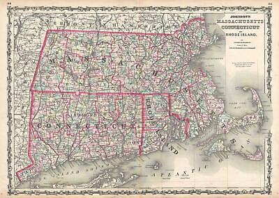
$15.00 Shipping Location: Brooklyn, United States 1861 Johnson Map of Massachusetts. Connecticut and Rhode Island WE SELL ONLY ORIGINAL ANTIQUE MAPS- NOT REPRODUCTIONS Title: Johnson's Massachusetts. ... moreConnecticut, and Rhode Island. Description: This is Johnson and Browning’s 1861 map of Massachusetts. Connecticut and Rhode Island. Covers the states divided into counties with special attention to transportation, especially roads, railroads, and canals. Includes parts of Long Island(East Hampton and Montauk) as well as Nantucket, Cape Cod and Martha’s Vineyard. Features the ribbon style border common to Johnson’s atlas work from 1860 to 1862. Steel plate engraving prepared by A. J. Johnson for publication as plates no. 25 and 25 in the 1861 edition of his New Illustrated Atlas… This is the last edition of the Johnson’s Atlas to bear the Johnson& Browning imprint. Size: Printed area measures 17.5 inches high by 24 inches wide. Condition: Very good condition. Original centerfold. Minor toning. Blank on verso. Shipping: Due to recent increases in United States Postal Service rates we have been forced to increase our shipping rates. Shipping rates are not negotiable. Items are shipped within three business days of receiving payment. We are happy to consolidate shipping where possible. The following shipping options are available: 1. USPS Domestic Express Mail(35 USD) USA Only. 2. USPS Priority Mail(15 USD) USA Only. 3. USPS International Express(35 to 55 USD) Recommended service for all international parcels. You will be invoiced at the lowest Express Mail rate possible. 4. USPS Priority Mail(35 USD) Available to only certain countries. Due to high instances of loss. This service is specifically NOT AVAILABLE to MAINLAND CHINA or INDIA. 5. Federal Express is available upon request. This is the only service option available to India and Africa. Price is quoted upon request following the auction. We can also use your Federal Express Account. Insurance: All shipments are insured privately against loss and damage. All of our shipments require a signature. If yo
Buy It Now
$15.00 Shipping Location: Brooklyn, United States It was issued shortly after the disaster to satisfy public interest in the devastating event. The caption here states that over 150 perished, erroneous ... moreinformation that was probably due to the intense fervor for news regarding the disaster.
Buy It Now
$15.00 Shipping Location: Brooklyn, United States The map depicts the region from New York to Rhode Island and from Massachusetts to Long Island Sound. The line would not open until 1849 but accomplished ... morewhat many believed to be a difficult task. The New York and New Haven built along the shore of Long Island Sound, which, due to the many rivers that emptied into Long Island Sound, many believed to be an overly difficult task.
![]()
Buy It Now
$9.97 Shipping Condition: Unspecified Location: LONDON, United Kingdom New York. Southern part; Inset map of Catskill Mountains, The Hudson from Yonkers to Kingston, New York City and Vicinity Colour antique lithographic ... moremap. 1903 Title of map: New York. Southern part; Inset map of Catskill Mountains, The Hudson from Yonkers to Kingston, New York City and Vicinity' The image below shows an enlarged cross section from the centre of the map to show the level of printed detail. This map is folding hence the centrefold line may show on the image below: DATE PRINTED: 1903 IMAGE SIZE: Approx 39.5 x 28.0cm. 15.5 x 11 inches(Large) Please note that this is a folding map. ARTIST/CARTOGRAPHER/ENGRAVER: Unsigned PROVENANCE: Encyclopaedia Britannica" 10th edition Maps; published by Adam& Charles. Black. Edinburgh, London TYPE: Colour antique lithographic map VERSO: There is nothing printed on the reverse side. Which is plain CONDITION: Good; suitable for framing. Please check the scan for any blemishes prior to making your purchase. Virtually all antiquarian maps and prints are subject to some normal aging due to use and time which is not obtrusive unless otherwise stated. I offer a no questions asked return policy- see below. AUTHENTICITY: This is an authentic historic print. Published at the date stated above. I do not offer reproductions. It is not a modern copy. The term'original' when applied to a print means that it was printed at the first or original date of publication; it does not imply that the item is unique. Print' means any image created by applying an inked block to paper or card under pressure by any method including wood engraving, steel engraving, copperplate, wood cut and lithography. REMARKS: FRANCE: Gravures et Cartes anciennes. DEUTSCHLAND: Alte Lankarten und Stadt ansichten. ITALIA: Stampe& Mappe antiche. ESPAÑA: Mapas antiquos y impresiones antiguas. E and OE. Force Majeure. English law shall apply. RETURNS POLICY: I offer a no questions returns policy. All I ask is that you pay return shipping and mail back to me in original condition.
Buy It Now
$6.00 Shipping Location: Greenacres, United States There are five insets: Albany, Troy, Buffalo, Rochester, and New York City Harbor and vicinity. The map is dated 1874 in the lower margin and was published ... moreby Samuel Augustus Mitchell, Philadelphia.
Buy It Now
Free Shipping Location: Freeport, United States Owned jointly by Brian & Marc.
Buy It Now
Free Shipping Location: Freeport, United States
Buy It Now
$5.35 Shipping Location: Saint Petersburg, United States East Coast cities identified include St Augustin (located in East Florida), Charles Town, Washington, Philadelphia, New York and Boston. Sandy Hook in ... moreNJ is marked, as are Long Island and Cape Cod. There are no state boundaries West of New England.
Buy It Now
$31.15 Shipping Location: ANDOVER, United Kingdom 1 – Sketch A, Shewing the progress of the Survey in Section No. 1 From 1844 to 1851. Not stated [Washington: Published by Robert Armstrong, 1852], First ... moreEdition. SUPERINTENDENT OF THE UNITED STATES COAST SURVEY.
Buy It Now
$6.80 Shipping Location: Bolivia, United States First Edition. 72 pages; Huntington, LI atlas, publisher’s No. 2149A illustrated with color. ‘Pocket’ size approx. 5" x 8", each page opens to double ... morethat in the map section; glossy illustrated softcover.
Buy It Now
$35.00 Shipping Location: Goleta, United States Facsimile of 1679 Original Jasper Danckaerts Map New York from Brooklyn Heights Plate III / Marked G Hayward Company 171 Pearl St. NYDimensions: 9.5" ... morex 33.5"Condition: Generally VG with some centerfold reinforcement and other markings. A nice old facsimile of the single original map, which is housed in Long Island. Please see pictures showing item details and condition . . ,.
Buy It Now
$15.00 Shipping Location: Brooklyn, United States The map depicts the region from Barren Inlet, North Carolina to Point Judith, Rhode Island and from Washington, D.C. to the Atlantic Ocean. Highly detailed, ... moremyriad depth soundings are indicated all along the coast and in Long Island Sound, Delaware Bay, Chesapeake Bay, and along the Potomac River to Washington, D.C. Manuscript notations appear along the coast from Ocracock Inlet, North Carolina to Montauk Point on Long Island, complete with course information and other notes.
Buy It Now
$6.00 Shipping Location: Freeport, United States Rare Blissville Long Island City Queens New York 20 X 27 Linen Backed Atlas Map Plate-1.
Buy It Now
$4.00 Shipping Location: United States This is an antique 1873 map and not a reprint or reproduction. Rare, early map of this area. The map is printed on fine paper. The gorgeous handcoloring ... moreon the map is period to the map, this is before color printing.
Buy It Now
$11.80 Shipping Location: Eagle, United States Presented is an authentic map taken from the Historical Atlas of the World, published in 1875 by Higgins, Harney, & Co. of Chicago, IL. Original color.
Buy It Now
$5.00 Shipping Location: United States The linenbacking is period to the map and really protected it. This is a very rare map. The map is titled Roosevelt, 1906, this dates the map nicely. ... moreThe map is in very nice condition. This is an antique map and not a reprint or reproduction, the map is printed on thick fine paper.
Buy It Now
Free Shipping Location: Freeport, United States Owned jointly by Brian & Marc.
Buy It Now
$11.80 Shipping Location: Eagle, United States Presented is an authentic, old map taken from a dis-bound atlas published in 1873. Original hand color. Reverses to Newtown and Corona.
Buy It Now
Free Shipping Location: Freeport, United States Owned jointly by Brian & Marc.
Buy It Now
$4.00 Shipping Location: United States This is an antique 1873 map and not a reprint or reproduction. Rare, early map of this areas. The gorgeous handcoloring on the map is period to the map, ... morethis is before color printing. The map is from the very rare 1873 Beers Atlas of Long Island New York.
Buy It Now
Free Shipping Location: Savannah, United States Original 139-year-old Antique Map of New York Drawn & Engraved by E.F. Fisk for the 1885 Edition of The People's Cyclopedia of Universal Knowledge: A ... moreCompendium of Invaluable Reference in all Departments of the Arts and Life; Illustrated with More than Five Thousand Engravings and Over One Hundred Color Maps of Each State, Principal City, and Territory of the United States, Continents, and Countries Across the Globe. Intricate Detail of County Boundaries, Cities, Towns, Railroads, along with Rivers, Lakes, and other Natural Landmarks. Fine Map for the Collector or Historian. Great for American History and Family Genealogy. Makes an Imaginative and Creative Gift. Easily Framed.

Buy It Now
$15.00 Shipping Location: Brooklyn, United States 1859 Clark and Tackabury Wall Map of Connecticut WE SELL ONLY ORIGINAL ANTIQUE MAPS- NOT REPRODUCTIONS Title: Clark& Tackabury's New Topographical ... moreMap of the State of Connecticut. Description: An attractive 1859 first edition example of Richard Clark and Robert& George Tackabury's important wall map of Connecticut. The map covers the entire state of Connecticut with impressive detail including topography shown by hachure. Color coding by county and township, notes on railroad lines, rivers, and roads, countless depth sounding all along the Long Island Sound, and multiple insets of Connecticut cities. Drawn on a scale of 1.5 miles to the inch, Clark& Tackabury's map purports to be the most complete map of Connecticut ever published, identifying'the location of all public buildings, churches, school-houses, manufacturing establishments, and private residences' Nine insets focus on the cities of Norwalk, New London, Bridgeport, Hartford, Norwich, Middleton, Waterbury, Norwich, Waterbury, Stamford and New Haven, where Yale College is identified. To the left of the map proper are 1850 census population statistics for both counties and cities arrayed in a table. Cartographically this map is an amalgam of older maps and new private survey work produced by G. M Hopkins and Company of Philadelphia. The countless depth soundings along the Long Island Sound are drawn from the U.S. Coast Survey's work in this region. This is one of the last great wall maps of Connecticut in the 19th century. This map was printed in Philadelphia and sold by subscription in both wall and case format from March 2, 1859. Size: Printed area measures 57 inches high by 73 inches wide. Condition: Good. Professionally restored and backed with fresh linen. Original rollers. Part of top border missing- see image. Measurement includes rollers. Shipping: Due to recent increases in United States Postal Service rates we have been forced to increase our shipping rates. Shipping rates are not negotiable. Items are shipped
Buy It Now
$15.00 Shipping Location: Brooklyn, United States Published in 1873. Roughly covers from Bayside Avenue south to Walnut Avenue. Detailed to the level of individual properties and buildings with landowners ... morenoted. This is probably the finest atlas map of this part of Queens, New York, to appear in the 19th century.
Buy It Now
$4.50 Shipping Location: Slingerlands, United States This is a USGS map of the Saybrook Quadrangle, surveyed in 1890, edition of 1893 and printed in 1910. This map shows the Connecticut River entering Long ... moreIsland Sound. Note that the map is a scale of 1:62,500.
Buy It Now
$5.99 Shipping Location: Lynbrook, United States
Buy It Now
Free Shipping Location: Alna, United States Toningalong the fold lines. Small separations at the fold cornersline in 3 places. The chart has been protected in the 1865 US Coast Survey book for the ... morepast ~150 years. This chart covers the area from Small Point, Maine to CapeCod and includes: Portland Harbor and surrounding Islands (e.g., Peaks Island,Long Island, etc.), Portsmouth Harbor, Cape Anne and Boston Harbor.
Buy It Now
$9.97 Shipping Condition: Unspecified Location: LONDON, United Kingdom 'United States Coast and Geodetic survey Primary triangulation between long Island and the blue ridge sections II & III'. United States Coastal and Geodetic ... moreSurvey. Title of map:'United States Coast and Geodetic survey Primary triangulation between long Island and the blue ridge sections II & III '.

Buy It Now
$10.00 Shipping Location: Chicago, United States Map Collectors Gather Around Copyright 1939. National Geographic Map National Geographic Map © 1939 Reaches of New York City. M20137) This map appeared ... morein the April 1939 issue of National Geographic Magazine. The borders of the map illustrate famous sites and people. The map is mounted and ready for framing. Approximately 26" X 29" The Reaches of New York City map features: Border illustrations of famous people& sites& an Inset of South Jersey There are historic monuments. Shrines and ruins Old churches. Battlefields, State capitals, county seats, and towns of interest are noted There are mountains. Rivers, lakes highways, railroads, and canals The map includes New Jersey. Southern New York, Western Connecticut and Western Massachusetts Printed by A. Hoen& Co. Baltimore, MD, U. S. A. Look over the markings and pictures. Not a reproduction– that is. This is the original National Geographic Supplement carefully mounted and preserved. Excellent Condition for its age I came across this collection at an estate sale some years ago. Each map is an original from the producer and not a reproduction. There is only one of each for sale. The maps are carefully and professionally mounted on what appears to be cotton or linen cloth. I will. As always, pack these carefully. They will be sent flat and will require a signature for pick up to protect your investment. Many are original National Geographic maps. They seem to range from the early to late 1920’s– 40’s. They are beautiful if I do say so and that is why I grabbed them originally. My kids are grown now and we no longer use them for educational purposes. So. Off they go. Will it be to you? Please carefully review the pictures and judge for yourself. As in all old maps there will be flaws. Carefully look over fold placement where they exist. Fading, marks, stains, corners, creases, etc. Thank you and good hunting. Packing. Shipping and signature required, $12.50 From my collection to yours with one easy bid. My de-collecting is your win! Good luc
Buy It Now
$8.79 Shipping Location: Greenacres, United States Original large-format 1848 blueback nautical chart of the eastern coast of the United States from Rhode Island to western Cuba, including the entire peninsula ... moreof Florida, published by E. & G.W. Blunt.
Buy It Now
$15.00 Shipping Location: Brooklyn, United States Centered on th colony of Massachusetts, Neal's map covers from the Hudson River and New York City east to Nova Scotia, it extend north to Lake Champlain ... more(Lake Iroquois) and south to Long Island and the Nantucket Shoals.
Buy It Now
$6.80 Shipping Location: Eagle, United States Presented is an authentic, old map taken from a dis-bound atlas published in 1873. Original hand color. Has several margin tears and marginal paper loss ... moreat the top left. Map reverses to Canarsie and New Lots.
Buy It Now
$47.35 Shipping Location: United Kingdom 101 x 114 cm. Printed in full colours. Laid down on linen, not dissected. Very good condition.
Buy It Now
$15.00 Shipping Location: Brooklyn, United States Services include deacidification cleaning flattening and backing. Condition: Good. Original linen backing fragile and split in places. Signature Required.
Buy It Now
$5.00 Shipping Location: East Meadow, United States An 6 panel fold out filled with photos and information on the area beaches. Map of 5 boro's and nassau County on reverse side. ALWAYS WALK AWAY WITH A ... moreDEAL. in good condition.
Buy It Now
$5.00 Shipping Location: Winter Springs, United States The linenbacking is period to the map and really protected it. This is a very rare map, I've never seen this map before. The map is titled Roosevelt, ... more1906, this dates the map nicely. The map is in very nice condition.
Buy It Now
$16.45 Shipping Location: Rochester, United States County : Suffolk, Norfolk, Plymouth. Title : Hull. Year : 1946. Condition : This map was part of a museum collection and is in excellent condition. A ... moresmall tear is present at bottom border. State : Massachusetts.
Buy It Now
$15.00 Shipping Location: Brooklyn, United States Published in 1873. Detailed to the level of individual buildings and properties with landowners noted. Richmond Hill was the vision Albon P. Man, a successfully ... morebanker who bought the Lefferts and Welling farms in 1868.
Buy It Now
$22.00 Shipping Location: New Hyde Park, United States This map is from the Actual Survey & Official Plans of 1907. Civil Engineers: George W. and Walter S. Bromley. Published by G.W. Bromley and Co. This ... morepage is from an original 100 year old Atlas crafted on an old-fashioned linen paper.
Buy It Now
$33.65 Shipping Condition: Unspecified Location: LONDON, United Kingdom Antique copperplate map, 1776. DATE PRINTED: 1776. Title of map:'A map of the country round Philadelphia including part of New Jersey, New York, Staten ... moreIsland & Long island'. 'A map of the country round Philadelphia including part of New Jersey, New York, Staten Island & Long island'.
Buy It Now
$16.00 Shipping Location: Boulder, United States Map includes Long Island, Long Island Sound, the Atlantic Ocean, Hudson River, and part of Massachusetts and Rhode Island. Excellent condition - coloring, ... morelines and text are all intact. Condition: Very good condition, one 1.5" tear in upper left hand corner.
Buy It Now
$6.00 Shipping Location: United States The linenbacking is period to the map and really protected it. This is an antique map and not a reprint or reproduction, the map is printed on thick fine ... morepaper. The handcoloring on the map is period to the map, this is before color printing.
Buy It Now
Free Shipping Location: Monroe, United States Very good shape for the age 120 years old.

Buy It Now
$15.00 Shipping Location: Brooklyn, United States 1668 Doncker Map of the Atlantic. With early Dutch New York(New Amsterdam) WE SELL ONLY ORIGINAL ANTIQUE MAPS- NOT REPRODUCTIONS Title: Pas Caart van ... moreBrazil en Nieu-Nederland van corvo en Flores tot de Barbados. Description: A fascinating and extremely rare 1668 nautical chart or maritime map depicting the northern Atlantic Ocean by Hendrick Doncker. Oriented with the East. This map covers from Newfoundland south to modern day Paraiba, Brazil; east as far as the Azores and Cape Verde Islands; and west as far as Hispaniola. Doncker derived this map from similar map issued in 1650 by Theunis Jacobsz. Although the usual projection, blank at the center with the eastern parts of North American and Brazil defined by the distant Azores and Cape Verde Islands, might seem bizarre to the modern eye, this was in fact a well-considered. Jacobsz drew this based upon Blaeu's monumental 1630 West Indische Paskaert. His intention was to present the most important information on Blaeu's great map in easily accessible form. This this map focuses on those areas most interesting to the 17th century Dutchman, the Dutch VOC colonies in Nieu-Nederland(New Amsterdam/ New York City) and in Brazil(where the VOC was faring poorly in a war with Portugal over domination of the valuable sugar trade) The Canary Islands and the Azores have no doubt been included as the map's eastern most coverage because they are the traditional gateways to Europe. The Spanish controlled territories to the west, in Mexico, the Caribbean, and the Gulf of Mexico, were of little comparative interest. While Doncker draws on Jacobsz for this map's basic form, it is by no means a slavish copy. The map has been updated throughout with more advanced toponymy(for example'Gebroken Lant' is introduced for Long Island) and an updated presentation of the inland waterways, particularly the St. Lawrence and Amazon Rivers. Shading has also been added to illustrate offshore shoals and reefs. In New York and New England, New Amsterdam is named and the Hud
Buy It Now
$12.00 Shipping Location: Poughkeepsie, United States [2] Part of the town is designated the Nantucket CDP, or census-designated place. It is connected by a 30 km (19 mi) wide isthmus between Terrenceville ... moreand Monkstown. [1] south from Cape Cod. It is the only such consolidated town-county in Massachusetts.
Buy It Now
$4.95 Shipping Location: Cranford, United States A very RARE early guide map of New York City - circa 1857. Our example is complete - Our example has not had much exposure to light and is therefore it ... moreis white and not yellowed. Surrounding Manhattan is Jersey City, Hoboken and Elysian Fields.

Buy It Now
$15.00 Shipping Location: Brooklyn, United States 1831 Thrall Pocket Map of Connecticut WE SELL ONLY ORIGINAL ANTIQUE MAPS- NOT REPRODUCTIONS Title: Map of Connecticut from actual Survey. Description: ... moreAn extremely scarce map. This is Willis Thrall's 1831 pocket map of Connecticut. Thrall's map, which is dated at bottom center, covers the entire state of Connecticut as well as the adjacent Long Island Sound. Connecticut is here divided into eight color coded counties. Inset plans of New Haven, Hartford, and the New England States, rest in the lower right quadrant. The upper right quadrant features a profile of the Farmington Canal. A list of Connecticut governors starting with John Winthrop of 1665, and updated to include John S. Peters of 1831, appears in the upper left quadrant. According to the Connecticut map historian Edmond Thompson, this map was first engraved by Daggert and issued between 1827 and 1829. This is the second edition, published in 1831 with an update to the list of governors and the names of Thrall and Ely added to the imprint. It was later reissued by different publishers in 1836, 1847, 1854 and 1858. This edition and the virtually unknown first edition are by far the most desirable and are found in few collections- a rare opportunity. It is also noteworthy that this map was published in New Haven, Connecticut. Size: Printed area measures 18.5 inches high by 22.5 inches wide. Condition: Good condition. Detached from and missing original binder. Some minor damage just encroaching on the left border were once attached to binder- see image. Backed with archival tissue for stability. Shipping: Due to recent increases in United States Postal Service rates we have been forced to increase our shipping rates. Shipping rates are not negotiable. Items are shipped within three business days of receiving payment. We are happy to consolidate shipping where possible. The following shipping options are available: 1. USPS Domestic Express Mail(35 USD) USA Only. 2. USPS Priority Mail(15 USD) USA Only. 3. USPS International Express(35 to 55 USD) Rec

Buy It Now
$15.00 Shipping Location: Brooklyn, United States 1862 Johnson Map of Massachusetts. Connecticut and Rhode Island WE SELL ONLY ORIGINAL ANTIQUE MAPS- NOT REPRODUCTIONS Title: Johnson's Massachusetts. ... moreConnecticut, and Rhode Island. Description: This is Johnson and Ward’s 1862 map of Massachusetts. Connecticut and Rhode Island. This rare map offers a fascinating snapshot of these two New England states shortly following the outbreak of the American Civil War. Map shows all three states in full with bold and dramatic color coding according to county and district, also details transportation routes, especially roads, railroads, and canals. Includes parts of Long Island(East Hampton and Montauk) as well as Nantucket, Cape Cod and Martha’s Vineyard. Features the strapwork style border common to Johnson’s atlas work from 1860 to 1863. Steel plate engraving prepared by A. J. Johnson for publication as plates no. 25 and 26 in the 1862 edition of his New Illustrated Atlas… This is the first edition of the Johnson’s Atlas to bear the Johnson& Ward imprint. Size: Printed area measures 17.5 inches high by 24 inches wide. Condition: Very good condition. Original centerfold. Minor toning. Blank on verso. Shipping: Due to recent increases in United States Postal Service rates we have been forced to increase our shipping rates. Shipping rates are not negotiable. Items are shipped within three business days of receiving payment. We are happy to consolidate shipping where possible. The following shipping options are available: 1. USPS Domestic Express Mail(35 USD) USA Only. 2. USPS Priority Mail(15 USD) USA Only. 3. USPS International Express(35 to 55 USD) Recommended service for all international parcels. You will be invoiced at the lowest Express Mail rate possible. 4. USPS Priority Mail(35 USD) Available to only certain countries. Due to high instances of loss. This service is specifically NOT AVAILABLE to MAINLAND CHINA or INDIA. 5. Federal Express is available upon request. This is the only service option available to India and Africa. Price is quoted upon request

Buy It Now
$15.00 Shipping Location: Millbrook, United States This auction is for the extremely rare and 100% original and authentic antique map of the above region. Cartographer and year. This auction is only for ... morethe map that is pictured in this listing. I cannot stress enough how beautiful this map is up close compared to the photos that you see. Note that the photos do not do the map justice. This is truly an incredible map to behold! This is your chance to own a map that can be the centerpiece of your collection. Cartographer: Joseph Hutchins Colton(July 5. 1800- July 29, 1893) often publishing as J. H. Colton, was an important American map and atlas publisher active from 1833 to 1893(though the firm continued to published in 1897) Colton's firm arose from humble beginnings when he moved to New York in 1831 and befriended the established engraver Samuel Stiles. Colton recognized an emerging market in railroad maps and immigrant guides. Not a cartographer or engraver himself, Colton's initial business practice mostly involved purchasing the copyrights of other cartographers, most notably David H. Burr, and reissuing them with updated engraving and border work. His first maps, produced in 1833, were based on earlier Burr maps and depicted New York State and New York City. Between 1833 and 1855 Colton would proceed to publish a large corpus of guidebooks and railroad maps which proved to be very popular. In the early 1850s Colton brought his two sons, George Woolworth Colton(1827- 1901) and Charles B. Colton(1832- 1916) into the map business. G. W. Colton, trained as a cartographer and engraver, was particularly inspired by the idea of creating a large and detailed world atlas to compete established European firms for the U.S. market. In 1855 G.W. Colton issued volume one the impressive two volume Colton's Atlas of the World. Volume two followed a year later. Possibly because of the expense of purchasing a two volume atlas set, the sales of the Atlas of the World did not meet Colton's expectations and it was thus that, in 1856, they also issued the Atlas as
Buy It Now
$4.50 Shipping Location: United States This is an antique 1873 map and not a reprint or reproduction. Rare, early map of this areas. The map is printed on thick paper, with no printing on reverse, ... morethe map are titled Part of Whitestone Village, Town of Flushing Queens Co.
Buy It Now
$6.00 Shipping Location: United States The linenbacking is period to the map and really protected it. The map is in very nice condition. This is an antique map and not a reprint or reproduction, ... morethe map is printed on thick fine paper. The handcoloring on the map is period to the map, this is before color printing.
Buy It Now
$15.00 Shipping Location: Brooklyn, United States The map depicts the region from the Hackensack River in New Jersey to Brooklyn and Queens and from The Bronx to Staten Island. Freight depots throughout ... morethe city and on the New Jersey side of the Hudson River are overprinted in red, including Grand Central Station and Pennsylvania (Penn) Station.
Buy It Now
$4.00 Shipping Location: United States This is an antique 1873 map and not a reprint or reproduction. Rare, early map of this areas. The gorgeous handcoloring on the map is period to the map, ... morethis is before color printing. The map is from the very rare 1873 Beers Atlas of Long Island New York.

Buy It Now
$15.00 Shipping Location: Brooklyn, United States 1873 Beers Map of Flatlands. Brooklyn, New York City(Jamaica Bay, Canarsie) WE SELL ONLY ORIGINAL ANTIQUE MAPS- NOT REPRODUCTIONS Title: Flatlands. Kings ... moreCo. L.I. Description: A scarce example of Fredrick W. Beers’ map parts of the region of Flatlands. Brooklyn, New York City. Published in 1873. Includes the communities of Flatlands, South Greenfield, Canarsie and Jamaica Bay. Detailed to the level of individual properties and buildings with land owners noted. This is probably the finest atlas map these Brooklyn communities to appear in the 19th century. Prepared by Beers, Comstock& Cline out of their office at 36 Vesey Street, New York City, for inclusion in the first published atlas of Long Island, the 1873 issue of Atlas of Long Island, New York. Size: Printed area measures 15.5 inches high by 11.5 inches wide. Condition: Very good condition. Part of printed map on verso. Map runs off edge of paper. As issued. Shipping: Due to recent increases in United States Postal Service rates we have been forced to increase our shipping rates. Shipping rates are not negotiable. Items are shipped within three business days of receiving payment. We are happy to consolidate shipping where possible. The following shipping options are available: 1. USPS Domestic Express Mail(35 USD) USA Only. 2. USPS Priority Mail(15 USD) USA Only. 3. USPS International Express(35 to 55 USD) Recommended service for all international parcels. You will be invoiced at the lowest Express Mail rate possible. 4. USPS Priority Mail(35 USD) Available to only certain countries. Due to high instances of loss. This service is specifically NOT AVAILABLE to MAINLAND CHINA or INDIA. 5. Federal Express is available upon request. This is the only service option available to India and Africa. Price is quoted upon request following the auction. We can also use your Federal Express Account. Insurance: All shipments are insured privately against loss and damage. All of our shipments require a signature. If you have any questions please feel free to em
Buy It Now
$10.00 Shipping Location: Chicago, United States This is an original antique map of Connecticut with parts of Rhode Island and New York, featuring all of Long Island. It was published by Joseph H. Colton ... moreout of New York in 1856. Date: 1856 (published) New York.
Buy It Now
$10.00 Shipping Location: Boulder, United States Also shown is Long Island Sound, the proposed dike extension, dredged channel, college point, and Newtown and Flushing. Condition: Excellent.
Buy It Now
Free Shipping Location: Pawtucket, United States Includes large portions of the towns of Westbrook, Old Saybrook, Essex, Deep River. Scale 1:24,000.
Buy It Now
$4.00 Shipping Location: Winter Springs, United States This is an antique 1873 map and not a reprint or reproduction. Rare, early map of this areas. The gorgeous handcoloring on the map is period to the map, ... morethis is before color printing. The map is from the very rare 1873 Beers Atlas of Long Island New York.
Buy It Now
$10.00 Shipping Location: Boulder, United States
Buy It Now
$11.80 Shipping Location: Eagle, United States Presented is an authentic, old map taken from a dis-bound atlas published in 1873. Original hand color. Map reverses to Canarsie and New Lots.
Buy It Now
$14.43 Shipping Location: Brick, United States JOHNSON. ALVIN JEWETT Published by JOHNSON AND WARD. NEW YORK, 1863 Maps compiled. Drawn, and engraved under the supervision of J.H. Colton and A.J. Johnson. ... moreNote]The new plates, copyrighted by A.J. Johnson, are made exclusively for Johnson's New Illustrated Family Atlas. Others are the same as used in"Colton's General Atlas. Johnson and Ward were successors to Johnson and Browning(successors to J.H. Colton and Company) Imp. 4to, 123 p. col. maps(many double page) illus. OFFERED HERE IS ONE LARGE DOUBLE PAGE MAP OF NEW YORK CITY CONDITION: EXCELLENT SIZE: 18 X 26 1/2
|
|
|
In
|