-
Christian Collectibles
-
Christian Sheet Music
-
Vatican Stamps
-
Vatican Coins & Paper Money
-
Antiques
-
Antiquities
-
Architectural & Garden
-
Decorative Arts
-
Ethnographic
-
Furniture
-
Maps, Atlases & Globes
-
United States (Pre-1900)
-
AK, HI
-
AL, FL, GA, MS, NC, SC
-
AR, IA, KS, LA, MO, NE
-
AZ, CA, CO, NM, NV, UT
-
CT, MA, ME, NH, RI, VT
-
DC, DE, MD, NJ, NY, PA
-
ID, OR, WA
-
IL, IN, MI, OH, WI
-
MN, MT, ND, SD, WY
-
OK, TX
-
VA, WV, KY, TN
-
Entire US
-
United States (1900-Now)
-
United States (Date Unknown)
-
Africa
-
Asia
-
Australasia/ Oceania
-
Canada
-
Central America/ Caribbean
-
Europe
-
India
-
Ireland
-
Mexico
-
Middle East
-
North America
-
South America
-
United Kingdom
-
Maps on CD
-
World Maps
-
Globes
-
Mixed Lots
-
Reproductions
-
Price Guides & Publications
-
Other
|
In
Order by: Available to: eBay Affiliate Links
|
Buy It Now
Free Shipping Location: Sayville, United States
Buy It Now
$5.95 Shipping Condition: New Location: Las Vegas, United States Year: 1892. Comanche, Apache, Cheyenne, Cherokee Indian districts are represented. Cities, Towns and Military forts are clearly labelled. Map of the Indian ... moreand Oklahoma Territories. Each of our prints are custom reproductions printed on 68lb Heavyweight Enhanced Matte Art Paper.
Buy It Now
Free Shipping Location: Iowa City, United States Counties, County Seats,Cities; many Small Towns and Villages, Ports; Military Airfields and Forts; Rivers and Streams, Lakes; and other topographical ... morefeatures are located on this map. 1908 (Dated) Genuine Engraved Color Map.
Buy It Now
$6.90 Shipping Location: Audubon, United States It is an old, original map that was rescued from an unusable atlas. You will receive the exact antique map in the photos. Condition is very good, age ... moreconsidered.
Buy It Now
Free Shipping Location: Augusta, United States This 22" x 14 1/2" map is in VERY GOOD condition with light tone, soil, edge wear, and a fold in the middle as issued, from a disbound Cram's atlas ©1912. ... more"An Authentic Original Map Not A Reproduction".
Buy It Now
$4.55 Shipping Location: Oakland, United States This antique map from Rand McNally & Co. features Oklahoma and Indian Territory from 1904. The intricate details and beautiful illustrations on the map ... moremake it a perfect addition to any collection or display. The map measures 7x6 and is in excellent shape, ready to be framed or enjoyed as is. It depicts the US State of Oklahoma, with important aspects such as the year and the cartographer/publisher detailed in the item description. Don't miss out on this rare piece of history!
Buy It Now
Free Shipping Location: Augusta, United States "An Authentic Original Map Not A Reproduction".
Buy It Now
$9.00 Shipping Location: Cambridge, United States Original print from "Hammond's Standard Atlas and Gazetteer Of The World" Hardcover first edition book 1938. Great antique condition with less than typical ... morepaper wear. One edge is raw cut. Opposite side may or may not have prints or text which may or may not be related to one shown.
Buy It Now
$5.95 Shipping Condition: New Location: Las Vegas, United States Comanche, Apache, Cheyenne, Cherokee Indian districts are represented. Cities, Towns and Military forts are clearly labelled. Map of the Indian and Oklahoma ... moreTerritories. “Vibrant and bright! Pic does not do it justice.looks amazing!”.
Buy It Now
$6.09 Shipping Location: Falkville, United States Track the history and growth of Oklahoma through the map system. Learn the official state song, see the different flags flown, the changing of the government. ... moreA bundle of 9 total pieces. First up is 1956, last is 2007, centennial map.
Buy It Now
Free Shipping Location: Sayville, United States
Buy It Now
$3.00 Shipping Location: Harborton, United States ANTIQUE MINIATURE INDIAN TERRITORY MAP. This is an antique Indian Territory map which was carefully removed from a very small atlas. Note light creasing ... moreand there is unrelated text on the reverse side.
Buy It Now
Free Shipping Location: Mcminnville, United States Original and authentic, this 1911 Century Atlas map plate from the Century Dictionary Cyclopedia is a remarkable find. I can always make a deal for multiple ... moreas well!
Buy It Now
$6.95 Shipping Location: Dover, United States Issued 1872, New York by Asher & Adams. Arkansas and Part of Indian Territory. Late 19th century lithographed map with original hand color.
Buy It Now
$6.90 Shipping Location: Audubon, United States It is an old, original map that was rescued from an unusable atlas. You will receive the exact antique map in the photos.
Buy It Now
$5.95 Shipping Condition: New Location: United States Tulsa, Oklahoma. Tulsa 1918. Year: 1918. These Historic Art Prints are suitable for framing, mounting or direct display on any wall! “Vibrant and bright! ... morePic does not do it justice.looks amazing!”.
Buy It Now
Free Shipping Location: Augusta, United States This 22" x 14 1/2" map is in VERY GOOD condition with light tone, soil, edge wear, and a fold in the middle as issued, from a disbound Cram's atlas ©1901. ... more"An Authentic Original Map Not A Reproduction".
Buy It Now
$4.95 Shipping Location: Willow Grove, United States This is an ORIGINAL Oklahoma map taken from a 1920s atlas. There is text and a map index for this map on the reverse side of this map page.
Buy It Now
$5.40 Shipping Location: Elkhorn, United States Oklahoma Map from 1911 Rand McNally Atlas with State History. I also rely on internet research.
Buy It Now
$4.13 Shipping Location: Oklahoma City, United States Good condition.
Buy It Now
$4.95 Shipping Location: Willow Grove, United States
Buy It Now
$5.95 Shipping Condition: New Location: United States Bartlesville, Oklahoma. Bartlesville 1917. Year: 1917. These Historic Art Prints are suitable for framing, mounting or direct display on any wall! “Vibrant ... moreand bright! Pic does not do it justice.looks amazing!”.
Buy It Now
$3.95 Shipping Location: Nashville, United States Please see all images... Single page, single sided printing. Antique "as found" Condition Map has two vertical folds Some tears on border. Top appears ... moreto have been cut about 5 3/4" long from left to center. Creases & toning. Approx. Size: 9 7/8 x 13 1/2 inches SCROLL DOWN Click to enlarge. See all images for condition We will combine shipping on multiple purchases... PLEASE WAIT TO PAY UNTIL YOU RECEIVE OUR NEW COMBINED SHIPPING INVOICE. Please read the entire write-up.
Buy It Now
$4.95 Shipping Location: Willow Grove, United States This is an ORIGINAL OKLAHOMA STATE map taken from a 1942 atlas. There is a map image and text on the reverse side of this map page.
Buy It Now
Free Shipping Location: Alameda, United States
Buy It Now
Free Shipping Location: Augusta, United States This 22" x 14 1/2" map is in VERY GOOD condition with very light tone, soil, and a fold in the middle as issued, from a disbound Cram's atlas ©1904. "An ... moreAuthentic Original Map Not A Reproduction".
Buy It Now
$6.00 Shipping Location: Monroe, United States ORIGINAL 1909 GUIDE BOOK WITH MAP OF TEXAS AND OKLAHOMA. DATED- MAY 1909. POOLE BROTHERS.
Buy It Now
$5.95 Shipping Condition: New Location: Las Vegas, United States This is a great map of the Counties of the State of Texas & Indian Territory Circa 1875. County map of Texas, and Indian Territory. “Vibrant and bright! ... morePic does not do it justice.looks amazing!”.
Buy It Now
$3.54 Shipping Location: Mishawaka, United States Sand Springs Tulsa Oklahoma USGS Topographic Map Vintage Original Printed 1983 22x27 Inches and would look great in a frame. See Photos for condition ... moreIf you have any questions please ask. Feel free to visit my store for more antique maps and prints on American History and many other subjects. Most offers accepted.
Buy It Now
$3.90 Shipping Location: Tucson, United States I have lots of maps available. Please message me for better pictures and/or offers. Shipping costs can be refunded for more than 3 purchases.
Buy It Now
$13.85 Shipping Location: Dover, United States Issued 1887, Philadelphia by Bradley, successor to S.A. Mitchell. ON reverse is a full page detailed map of the state of Colorado. Wonderful late 19th ... morecentury lithographed map, with original hand color.
Buy It Now
$11.85 Shipping Location: Dover, United States Issued 1890, NY by Scribner & Black. Scarce oversized folio sheet late 19th century color lithographed map. Texas and Indian Territory.
Buy It Now
$4.00 Shipping Location: Harborton, United States There is another map on the reverse side.
Buy It Now
$4.95 Shipping Location: Willow Grove, United States This is an ORIGINAL early 1920s Oklahoma map taken from a 1920s atlas. Unique to this map is that it indicates early State highway numbers. On the reverse ... moreside of this map page is a color map of Oklahoma which includes early electric rail lines.

Buy It Now
$3.25 Shipping Location: Enterprise, United States THIS ITEM IS A GENUINE ORIGINAL VINTAGE MAP FROM THE SOURCE/DATE LISTED Name- Oklahoma. And Indian Territory Date- 1904 Source- Crams New Unrivaled Modern ... moreAtlas By- George F. Cram Published By- George F. Cram Size- about 14.5x22.25" Reverse has index of towns, sometimes related, sometimes not Condition- Nice. Short tear up from bottom edge repaired on reverse with neutral archival tape Yes! We Do Combine Shipping on Multiple Purchases! NO RESERVE! Happy Bidding! Buyer pays shipping/packing. We use very secure packaging methods and materials. And all shipments within the United States will be made with the protection of the new USPS Parcel shipping category. First Class or Priority. Depending on weight) Note that certain items may be shipped in the USPS Media Mail category. If appropriate. Payment due within 14 days after our initial after auction contact. Pennsylvania residents MUST add applicable SALES TAX or send resale number. Thanks. Good Luck! To See Our Other Auctions and Store Items CLICK HERE! Powered by
Buy It Now
$5.95 Shipping Condition: New Location: Las Vegas, United States Year: 1892. Comanche, Apache, Cheyenne, Cherokee Indian districts are represented. Cities, Towns and Military forts are clearly labelled. Map of the Indian ... moreand Oklahoma Territories. “Vibrant and bright!
Buy It Now
Free Shipping Location: Augusta, United States FREE: Acid-free date card (a modern lithographic copy) included with your map. "An Authentic Original Map Not A Reproduction".
Buy It Now
Free Shipping Location: Augusta, United States "An Authentic Original Map Not A Reproduction".
Buy It Now
$5.00 Shipping Location: Canada DATE OF ISSUE: 1904. ORIGIN OF THE MAP: "The World-Wide Atlas of Modern Geography" published by W. & A. K. Johnston Ltd., Edinburgh and London, UK.
Buy It Now
$5.00 Shipping Location: Canada DATE OF ISSUE: 1951.
Buy It Now
$4.00 Shipping Location: Harborton, United States 1914 on the bottom left corner. Antique state map of Oklahoma which was carefully removed from an atlas. The map is dated. ANTIQUE OKLAHOMA STATE MAP.
Buy It Now
$4.99 Shipping Location: Fairview, United States Condition: The map is in Good condition with another map on the reverse. The pics are of the actual map. An Authentic Antique Map: Not a Modern Reproduction! ... moreIt is from the.
Buy It Now
Free Shipping Location: Augusta, United States "An Authentic Original Map Not A Reproduction".
Buy It Now
$4.55 Shipping Location: Oakland, United States The map is in great shape and has been well-preserved over the years.
Buy It Now
$4.95 Shipping Location: Willow Grove, United States There is a map image and text on the reverse side of this map page.
Buy It Now
$12.35 Shipping Location: Lumberton, United States Please see all photos for condition. Unfortunately, I wish I could give you some history to this as it appears to be home made, but I can't confirm that.
Buy It Now
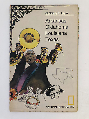
$5.49 Shipping Location: Georgetown, United States Template By Froo! National Geographic Map- 1974 Close-Up USA Oklahoma Texas Louisiana Arkansas National Geographic Map- 1974 Close-Up USA Oklahoma Texas ... moreLouisiana Arkansas Vintage 1974 two sided map Close-Up USA. Map shows Oklahoma, Louisiana, Arkansas, and Texas. The opposite side includes lots of historical information on the area by National Geographic Society. The map measures approx 35" x 23" in size. Never Unfolded. Shipping: All orders are carefully packaged. With a(Handle With Care Sticker) on the packaging. All orders ship the same or next business day. We ship orders Monday to Saturday. Orders placed before 2 pm(CST) on Fridays will ship on Saturday. We ship all orders via the United States Postal Service: First Class. Media Mail, Parcel Post, or Priority Mail, all include tracking numbers. Multi-Item Orders: We do combine shipping costs on multi-item orders. In order to receive the best shipping cost possible for your specific order please place your order. But before paying, request an invoice from us with combined shipping. We will return to you an adjusted invoice with the best shipping price for your order. Return Policy: Refunds given as money back or exchange(buyer’s choice) The buyer must pay return shipping. Please contact me within 14 days after receiving the item. Privacy Policy: Our company will never share your personal information in any way with an outside company. Our company will not send you unsolicited advertisements. Most reasonable offers are accepted. PayPal only. Please. Payment is expected within 2 days of auction end; immediate payment if you use Buy It Now. I will try and answer any questions. I am not an expert on anything I sell. And do my best to describe each item accurately. I buy many different items for the purpose of reselling them here on ebay. Any descriptions I give indicating the condition of item(s) such as: vintage. Antique, excellent, very good, good, and poor, or levels of functioning are purely subjective to what I observe, test and think of the item.
Buy It Now
$6.05 Shipping Location: Nevada City, United States MAP OF INDIAN TERRITORY AND OKLAHOMA Reproduction 1890. Shipped with USPS Ground Advantage.
Buy It Now
Free Shipping Location: Springfield, United States Unique Album & Atlas of the World 1894. page 231,232 of Unique Atlas of the World from 1894 with boundaries of tribal lands, Kiowas, Comanche, Apache, ... moreChickasaw & Choctaw nations, Arizona side has Cochise, Yavapai.
Buy It Now
$6.90 Shipping Location: Frankfort, United States VTG 1897 14.5" x 10.7" TWO SIDED MAP.
Buy It Now
$4.00 Shipping Location: Harborton, United States Neat Oklahoma picture map features sketches of people, vegetation, farming, and more. These make fun gifts!
Buy It Now
$6.95 Shipping Location: Dover, United States Map of Oklahoma and Indian Ters. Late 19th century color lithographed map.
Buy It Now
Free Shipping Location: Schertz, United States 1909 IOWA OKLAHOMA Multi-Color ANTIQUE/VINTAGE MAP Rand-McNally 1911 Atlas Source: From the Rand-McNally New Ideal State and County Survey and Atlas. ... more1911. Maps dated 1909. Size: The page is 11 1/2" by 14" The graphic area is approximately 10" by 12 3/4" Including all information outside of border. Bordered area is 9 1/8" by 12 3/8" Details: The maps shown are on opposite sides of the same page. Photos show the title and copyright pages of the original atlas. And are NOT included in the offering. Condition: Overall excellent for age. Paper is still strong and supple. Some age darkening. No tears. Creases, stains, etc. Shipping: Inexpensive shipping. Only $1.25. Maps shipped rolled up in shipping tube. RcmdId ViewItemDescV4,RlogId p4%60bo7%60jtb9%3Fv%7F.rpn35%3E-13d8575373a-0xfe-
Buy It Now
$3.50 Shipping Location: Dover, United States Year Published: 1949. Canadian Quadrangle Oklahoma- 30 Minute Series. The map in the photo is the actual map you will receive. Water Bodies: Canadian ... moreRiver, Coal Creek, Crowder Reservoir, Deep Fork, Elk Creek, Eufaula Lake, Featherston Creek, Lake Henryetta, Lake McAlester, Longtown Creek, Middle Creek, Mill Creek, Nichols Lake, North Canadian River, Rock Creek, Scipio Creek, Shell Creek, Wolf Creek.
Buy It Now
$5.45 Shipping Location: Davenport, United States Vtg 1978 Rand McNally atlas page with Ohio on one side and Oklahoma on the other. Nice vibrant colors. Last picture is the title page of the atlas the ... moremap is from and is not included with the listing - for reference only. The page is approx 13.5 x 10.5
Buy It Now
$4.69 Shipping Location: Greenacres, United States The map was published by George F. Cram, Chicago, in 1889 and is titled "Map of the Oklahoma Country in the Indian Territory.".
Buy It Now
Free Shipping Location: Augusta, United States FREE: Acid-free published date card (a modern lithographic copy) included with your map. "An Authentic Original Map Not A Reproduction".
Buy It Now
$6.05 Shipping Location: Mansfield, United States
Buy It Now
$5.00 Shipping Location: Canada DATE OF ISSUE: 1908.
Buy It Now
$5.00 Shipping Location: Canada DATE OF ISSUE: 1949. ORIGIN OF THE MAP: "Encyclopaedia Britannica World Atlas", published by Encyclopaedia Britannica, Chicago, London, Toronto.
|
|
|
In
|
1909 OKLAHOMA RAILROADS MAP
1909 OKLAHOMA RAILROADS MAP Shipping Info | Business Policies | Also Available Description mint condition! Shipping Info Business Policies Also Available
|
|
|
OKLAHOMA GHOST TOWNS MAP
OKLAHOMA GHOST TOWNS MAP Shipping Info | Business Policies | Also Available Description 638 Oklahoma ghost towns including the dates the Post Offices were opened and closed! This map was copyrighted in 1971 and therefore cannot be reprinted without permission. Actual size of map is 17" X 22" This map is in new mint condition! A great tool for any metal detectorist and very interesting to all true Okies! Shipping Info Business Policies Also Available
|
|
|
PAWNEE, OKLAHOMA, 1929 TOPO MAP
PAWNEE. OKLAHOMA, 1929 TOPO MAP Shipping Info | Business Policies | Also Available Description loaded with old schools which are long gone now and shows buildings in almost every square mile! Fits to the north of the Ripley quadrangle which I also have listed. This map is a more modern copy. Is crystal clear, and is in mint condition! Shipping Info Business Policies Also Available
|
|
|
100 year old atlas color page map Oklahoma Indian Territory Guthrie is Capital
1902 Pictorial Atlas of the Greater United States and World Published by George F Cram Book Copyrighted 1902- Large Page Map of Oklahoma and Indian Territory Capital is still Guthrie in Logan County. And not yet Oklahoma City. + + + Reverse side of page is a map of part of West Texas + + + + The map is too wide to fit on my scanner. Lots of details on these maps. See the closeups for examples. page measures 11" X 14-1/2" + + + There is usual darkening from age around the edges of the pages from this atlas and some smudges from handling. But overall the condition is good considering the paper is just over 110 years old! Also. Edges of some pages my have some minor water staining outside the map area. All of my maps are originals. I do not destroy good books. But rescue pages from damaged and ruined atlases. I mail maps rolled up ... morein a tube for protection. Which I have found it to be the most reliable way for the map to arrive without damage. I have over a thousand other- city- state- region- territory- country- maps that I have not yet listed, so let me know if you cannot find what you are looking for. + + + Buyer to pay shipping outside the US. So please check before bidding. Ask any questions.
|
|
|
1892 Oklahoma & Indian Territory Original Color Atlas Map** Agencies, Forts
1892 Oklahoma and Indian Territory Original Dated Color Atlas Map Gorgeous. Original 18 92 Oklahoma& Indian Territory Color Atlas map. New Mexico map is on the back. This is an ORIGINAL.NOT A REPRINT. 12 1 + year-old D ated 1892 on the front atlas map.The total size of the entire map measures 13 1/2" x 10 3/4" with the borders. The map includes area and population; It shows towns. Indian Industrial School, Stations, Spencer, Cochrans's and Robbinson's Academies. Forts, Agencies, Mili tary and Indian Reserves, railroads. Rivers, and other Geographic features, etc. Great, Historic Item. NOTE: This map doesn't show roads. NOTE CONDITION: The map has a some lite border and corner wear. the borders a re a little brownish, Otherwise. It is in Nice Condition and will look wonderful matted and framed(These old maps make ... moregreat gifts) Please see the attached photo to view the Map. And a couple of closeup sections of the map. Please note that the map is too large for my scanner.There is a border all the way around the map.Also. The map is much clearer than the scan illustrates. The printing is small but very clear and readable* Minimum bid for this 12 1 year-old map starts at only $ 19.95 or purchase it for only $2 3.95. U.S. Buyer pays $3.00 for shipping. $4.00 shipping to Canada; $6.00 to Europe. 1-4 maps can be combined to save on shipping. Maps are shipped in sturdy mailing tubes. Please Note: This is an original 18 92 D ated atlas map. For the winning bidder. I will enclose a copy of the 1892 Indian Territory and Oklahoma indexes which lists the population and numer ous towns with population for some of them; ie. Bowman had 10 people. If you have any questions about this map or any of my items. Please email me before bidding. Thanks! 1 231 12 IndTerr 92( M) Please visit my Ebay store to view my Indian Territory. Oklahoma, Texas, Dallas, New Mexico, Georgia, Atlanta, Mississippi and other vintage maps. Thanks for looking! ALL INTERNATIONAL BUYERS PLEASE DON'T BID UNTIL YOU
|
|
|
OKLAHOMA COUNTIES AND RIVERS MAP
OKLAHOMA COUNTIES AND RIVERS MAP Shipping Info | Business Policies | Also Available Description crystal clear print and is in mint condition! Shipping Info Business Policies Also Available
|
|
|
OKLAHOMA HISTORICAL MAP
OKLAHOMA HISTORICAL MAP Shipping Info | Business Policies | Also Available Description forts. Camps, fights, missions and some lost treasure sights! This map was copyrighted in 1971 and therefore cannot be reprinted without permission. Actual size of map is 17" X 22" This is a modern copy and is in new mint condition! A great tool for any metal detectorist and very interesting to all true Okies! Shipping Info Business Policies Also Available
|
|
|
1901 Oklahoma & Indian Territory Antique Color Atlas Map** ... 112 Years-Old!!
1901 Oklahoma& Indian Territory Antique Color Atlas Map* 112 Years-Old! Gorgeous. Original 1 90 1 Oklahoma and Indian Territor y Antique Color Atlas Map. This is an ORIGINAL.I DO NOT SELL REPRINTS. 1 1 2 + year-old undated atlas map.that measures 1 4" x 1 1" with the borders and would look wonderful matted and framed. The map is indexed on the side border where it lists Counties. Indian Nations and sever al towns with populations for a few of them; The map also shows towns and cities. Forts. Reserves. Major railroads, rivers and other points of interest, etc. Great. Historic Item. NOTE: The map doesn't include roads. NOTE CONDITION: The map has light border and corner wear. Otherwise, it is in Nice Condition. Please see the attached photo to view the Map and a closeup section of the map. Please note that the map is too large ... morefor my scanner.also. All of the printing is much clearer than the scan illustrates, towns, etc. are very clear and readable* Minimum bid starts at only $ 1 4.95 or purchase it for only $1 6.95. U.S. Buyer pays $3.00 for shipping. 1-4 maps can be combined to save on shipping. NO INTERNATIONAL SHIPPING Please visit my Ebay store to view my other vintage maps and other items. PLEASE READ: This is an original Undated 1 90 1 atlas map. F o r the winning bidder. I will enclose a copy of the dated 1 90 1 copyright page to keep with their map. If you have any questions about this map or any of my items. Please email me before bidding. Thanks! 0 2 14 13* Okla 0 1. 2( c) P lease Visit My Ebay Store To View My Indian Territory. Oklahoma, Texas, Dallas, New Mexico, Colorado, and Other Antique Maps. Thanks for Looking! SORRY. BUT DUE TO THE RECENT INCREAS E IN INTERNATIONAL SHIPPING CO STS, I WILL NO LONGER SE LL TO BUYERS OUTSIDE THE U.S.
|
|
|
Oklahoma & Indian Territory Map: Authentic 1897 (Dated) Tribes, Towns, Railroads
1897 Engraved Color Map Oklahoma and Indian Territory Satisfaction Guaranteed This is a 110+ Year-Old Map NOT a Reproduction This map was removed from the Century Atlas. Published by The Century Co. in 1897. It is printed on a single sheet with a fold in the center. The sheet is blank on the reverse with the exception of the map name and number. Dated 1897 on the face of the map. The boxed map area is about 10" by 15" And there are sufficient borders to allow easy matting or framing. Shown below without the full borders to allow the image to load a bit more quickly. This color map of Oklahoma and Indian Territory is dated 1897 on the face and was"specially engraved for the Century Co. by the Matthews-Northrup Co. Buffalo. NY" This map includes fine topographic& political detail. Such as: counties, cities, towns, rivers ... moreand mountains. Principal railroads are shown in red and for the most part. Identified. A close-up of this map showing the area around Oklahoma City is pictured below to give an example of the engraving and detail. Bid with confidence- Returnable for any reason within 10 days for prompt refund. Powered by The free listing tool. List your items fast and easy and manage your active items.
|
|
|
LUKFATA, OKLAHOMA, 1896 TOPO MAP
LUKFATA. OKLAHOMA, 1896 TOPO MAP Shipping Info | Business Policies | Also Available Description mint condition! Shipping Info Business Policies Also Available
|
|
|
PAWHUSKA, OKLAHOMA, 1908 TOPO MAP
PAWHUSKA. OKLAHOMA, 1908 TOPO MAP Shipping Info | Business Policies | Also Available Description crystal clear. And is in mint condition! Shipping Info Business Policies Also Available
|
|
|
1906 Pioneer Press atlas page original map Texas / Oklahoma capital was Guthrie
Nice old maps from The 1906 Pioneer Press Pictorial Atlas of the World Texas Copyright date is 1904 + + + Reverse side is a map of Oklahoma and Indian Territory Notice the capital of Oklahoma was Guthrie and not yet Oklahoma City Copyright date is 1904 + + + Page measures 10-1/4" X 13-3/8" lots of details on map- see closeups Good condition with some smudges and foxing that is typical for this vintage. Also some slight water staining along the edge. All of our maps are originals. We do not destroy good books. But rescue pages from damaged and ruined atlas books. Old maps are mailed rolled up in a tube for protection. Which we have found to be the best way to get them there safely. Buyer pays for mailing outside the US. So please check before bidding. If you cannot find what you are looking for. Let us know. We have over a thousand ... moreold– city– state– region– territory– country– maps that have not been listed yet. Ask any questions. Thank you.
|
|
|
National Geographic MAP 1974 Close-Up USA SOUTHCENTRAL Oklahoma Texas LA Arkansa
Description: Double sided MAP/Supplement of Close-Up U.S.A: SOUTH CENTRAL(Arkansas. Louisiana, Oklahoma, Texas) by NATIONAL GEOGRAPHIC SOCIETY Date: October 1974 Supplement Condition: very good condition Size: 35 x 22 3/4 inches Magazine is not included. Please check out my store for its availability Serious Bidder Only Please. Ask question if any. Shipping: USA: $2.50 first class or $5.49 Priority Mail within the lower 48 states. For each additional map. Add $1 Free shipping with purchased of any magazine. Canada: $3.99 first class mail or $13.99 priority mail For each additional map. Add $1 Free shipping with purchased of any magazine. International: $5.99 first class mail or $17.99 priority mail For each additional map add $1 Free shipping with purchased of any magazine. Payment: Payment is due within 7 days. Please contact me within 3 ... moredays to arrange payment if you do not pay instantly by Paypal. Return: I do not except return unless I send the wrong item(s) or item(s) that are not as described. Item(s) returned must be in the same condition it was sent. Refund will cover the bid amount but not shipping.
|
|
|
1891 Ardmore Oklahoma Map - Carter County - 16x24
Ardmore. OK 1891 Size: 16" x 24" x Also Available in or from our eBay Store This is a classic Panoramic City Map. Originally published in 1891. This print shows a bird's eye view of Ardmore. Oklahoma( Indian Territory) as it looked in the late 19th century! This print. Which evokes the vivid images of a simpler time, is a custom reproduction printed on 68lb Heavyweight Enhanced Matte Art Paper. This Historic Map is suitable for framing. Mounting or direct display on any wall! Other Great Maps available: 000 Artscape Galleries/ Posters Past More Prints and Posters Available from our eBay Store! Shipping price includes delivery confirmation. We combine shipping for multiple purchases- add $1.00 for each additional print. All maps are professionally packaged to ensure that they arrive safely and undamaged: Your print is first rolled ... moreand inserted into a plastic sleeve before being placed into a Heavy-Duty mailing tube for delivery. We stand behind the quality of every print. If you are not satisfied with your purchase. Please contact us within 30 days to arrange for either an exchange or a full refund. gsrx_vers_468(GS 6.4(468)
|
|
|
Indian Territory (before Oklahoma) Authentic 1881 Map shows Tribes, Cities, RRs
Authentic 1889 Color Map of Indian Territory Showing tribal areas; all cities and towns; rivers; railroads& general topographical features Satisfaction Guaranteed This color map of Indian Territory(NO mention of Oklahoma Territory) was included in Encylopaedia(Encyclopedia) Britannica's Ninth Edition as published between 1876 and 1889. This is a genuine 130+ Year-Old map-NOT a reproduction. The map is printed on medium weight paper-blank on the reverse; and with a fold in the center Bordered area is about 11.5 x 9" Condition is very good-as shown. The above illustration is a very accurate representation of the map. And below is a close-up to show detail and quality. Bid with confidence- Returnable for any reason within 10 days for prompt refund. Powered by The free listing tool. List your items fast and easy and manage your active ... moreitems.
|
|
|
1879 INDIAN TERRITORY OKLAHOMA WEST GOVERNMENT MAP
History-Image Photo. Map& Poster Archive Search in titles& descriptions Browse Photographs by Category Historic Posters Historic Maps Shipping& Payment We combine shipping so you only pay one shipping charge regardless of how many items you purchase U.S. $ 5.95 Canada& Mexico $ 7.50 International $ 10.00 You will receive an email at the close of auction. Click on the payment link to complete payment. We accept all forms of auction payments that are allowed by ebay. You can also pay for your purchase over the phone with a credit card: 503) 408-2360 See our Framing work work Who are you buying from? This is a large and detailed Government Land Office map of the"Indian Territory" of the Oklahoma region. 1879. From Map: Indian Territory. 1879. Department Of The Interior. General Land Office, J.A. Williamson, Commissioner. ... moreCompiled from the official Records of the General Land Office and other sources by C. Roeser, Principal Draughtsman, G.L.O. Photo lith& print by Julius Bien 16& 18 Park Place, N.Y. Actual map is much sharper and detailed than the low resolution scanned image used here. Map measures approximately 24" by 30" 61 by 76cm) The map is a modern reprint. It is reprinted(a modern reprint) using premium semi-matte. Japanese paper and Ultrachrome ink, which has an archival rating of 125+ years. For more information about how the maps are made see our Custom Framing& Matting Options We offer a variety of sizes and options for framing your purchase. to see frames and prices Example of map detail: Frequently Asked Questions Is the resolution disappointing? No. Is the simple answer. Because we are dealing with historical pieces from a wide range of regions, creators and time periods, there is variation in the quality. However, we always ask ourselves if we would be pleased with a particular image framed and on display before we add it to our inventory. We do not carry low-quality"snapshots, cheap digital scans or multi-generational prints. When we create a large
|
|
|
1914 MAP OF OKLAHOMA VER
1914 MAP OF OKLAHOMA This original antique map gives you an opportunity to examine in exquisite detail a piece of history. If you are interested in the past of this country and its people or have a desire to study where your family may have come from. Then this map gives you a rare look as the area was about 100 years ago. Once matted and framed, this map would make a perfect gift for a family member or friend they'll cherish forever. Origin of the map: Hammond's Home& Office Atlas of the World. Published by C.S. Hammond& Co. New York, USA. Date of issue: 1914 Size: The sheet measures 13" x 10" 33 x 25.5 cm) S/H: The map will be shipped by Air Mail. The shipping charge is: USA- 6.50. World/Canada- 7.50. The price includes the insurance and a strong, cardboard tube with plastic plugs. Attention! There is no additional ... moreshipping charge for multiple purchases! Pay me securely with any major credit card through PayPal! Payment methods: US/Canada Buyers: Paypal. International Buyers: Paypal. Click Here. Double your traffic. Get Vendio Gallery- Now FREE! 37,RcmdId ViewItemDescV4,RlogId p4%60bo7%60jtb9%3Fuk.rp73%28d03%3C%3E37-13d13250967-0xfb-
|
|
|
Chickasaw Nation Indian Territory 1900 Map Oklahoma Comm Five Civilized Tribes
Chickasaw Nation Indian Territory 1900 Map Oklahoma Comm Five Civilized Tribes CHICKASAW Original"Department of the interior commission to the five Civilized Tribes Chickasaw Nation Indian Territory June 30th 1900" This 113 year old map features township. Cities, towns, rivers, creeks, and railroad lines. Folds as issued, very good condition, overall size 21 1/2' x 19' Purchase with confidence. We have been in the antique print, map, and document business since 1976 and guarantee our items as advertised. See additional photos below! To See More Photos/Scenes Powered by Click Here. Double your traffic. Get Vendio Gallery- Now FREE!
|
|
|
OKLAHOMA Map: 100+ Years Old showing Counties, Towns, Topography, Railroads
1908 Engraved Color Map: Oklahoma Satisfaction Guaranteed This color map of Oklahoma is dated 1908(the year following statehood) on the face and was included in an encyclopedia set published in 1907-1908. It was engraved and printed by the LL Poates Co. NY, NY. The map shows all of the state's counties; county seat towns; major cities and many small towns& villages; rivers& streams; and topographic detail. Most of the state's railroads and all of the Major railroads are shown in red. The map is printed on medium weight paper. Blank on the reverse and with a fold in the center(as issued) Bordered map area is about 8.5" x 10.5" with margins of between 1/2" to 1 inch all the way around to allow convenient matting. This is a very attractive older map and would look beautiful- matted and framed. If you want a detailed ... moremap showing the state as it was 100 years ago. This is a good one. Map is shown below without full margins; and the second image below is a close-up of the area around Oklahoma City and is included to show quality and detail. Bid with confidence- Returnable for any reason within 10 days for prompt refund. Powered by The free listing tool. List your items fast and easy and manage your active items.
|
|
|
1898 Texas Dated Color Atlas Map* Oklahoma & Indian Territory map on back
1898 Texas Dated Color Atlas Map* Oklahoma& Indian Territory map on back Gorgeous. Original 1898 Texas Dated Color Atlas Map. Indian Territory& Oklahoma color map is on the back. This is an ORIGINAL.NOT A REPRINT. 114 + year old Dated on the front of the atlas map.that measures 14" x 11" with the borders. The map is indexed on the borders where it lists the land area and Population broken down by race and gender. Plus the major towns and cities with their population. Dallas had 38.000 and Austin had 15,000 people) Also included on the map are the major railroads, Several forts, rivers and other geographic features, etc. Wonderful antique map. NOTE CONDITION: This map has lite border and corner wear, NOTE: The side border is lightly stained. this can be matted over, o t herwise. It is Nice Condition. Please see the attached ... morephoto to view the Texas map and a closeup section of the map. Also Please note that the color of the map is actually brighter than my poor scans show. NOTE: the map is too large for my scanner.There is a border all the way around the map.Also. The map is much clearer than the scan illustrates.All of the printing is very clear and readable* Minimum bid starts at only $19.95 or purchase it for $24.95. U.S. Buyer pays $3.00 for shipping. $4.00 shipping to Canada; $6.00 to Europe and Asia. 1-4 maps can be combined to save on shipping. PLEASE READ: This is an original Dated on the front atlas map.If you have any questions about his map or any of my items. Please email me before bidding. I prefer satisfied customers. Thanks! 121912 Texas98.2(R) Please Visit My Ebay Store to View My Indian Territory. Oklahoma, Texas, Dallas and Other Vintage Antique Maps. Thanks for Looking! RcmdId ViewItemDescV4,RlogId p4%60bo7%60jtb9%3Fv%7F.rpn34%3E-13d16d6e242-0x102-
|
|
|
1902 Oklahoma & Indian Territory Antique Color Atlas Map** ... 111 Years-Old!!
1902 Oklahoma& Indian Territory Antique Color Atlas Map* 111 Years-Old! Gorgeous. Original 1 902 Oklahoma and Indian Territor y Antique Color Atlas Map. This is an ORIGINAL.I DO NOT SELL REPRINTS. 1 1 1 + year-old undated atlas map.that measures 1 4" x 1 1" with the borders and would look wonderful matted and framed. The map is indexed on the lower side where it lists Counties. Indian Nations and sever al towns with populations for a few of them; The map also shows towns and cities. Forts. Reserves. Major railroads, rivers and other points of interest, etc. Great. Historic Item. NOTE: The map doesn't include roads. NOTE CONDITION: The map has light border and corner wear. Otherwise, it is in Nice Condition. Please see the attached photo to view the Map and a closeup section of the map. Please note that the map is too large ... morefor my scanner.also. All of the printing is much clearer than the scan illustrates, towns, etc. are very clear and readable* Minimum bid starts at only $ 1 4.95 or purchase it for only $1 6.95. U.S. Buyer pays $3.00 for shipping. 1-4 maps can be combined to save on shipping. NO INTERNATIONAL SHIPPING Please visit my Ebay store to view my other vintage maps and other items. PLEASE READ: This is an original Undated 1 902 atlas map. F o r the winning bidder. I will enclose a copy of the dated 1 902 copyright page to keep with their map. If you have any questions about this map or any of my items. Please email me before bidding. Thanks! 0 20213* Okla 02.1( c) P lease Visit My Ebay Store To View My Indian Territory. Oklahoma, Texas, Dallas, New Mexico, Colorado, and Other Antique Maps. Thanks for Looking! NO INTERNATIONAL SHIPPING a;06d2.RcmdId ViewItemDescV4,RlogId p4%60bo7%60jtb9%3Fuk.rp73%28%3Ea%3B06d2-13d16d6e1c9-0xfe-
|
|
|
1898 Map of Oklahoma and Indian Territory- NOT a repro
PACIFIC SHORE MAPS San Diego CA. 92124 Title: Oklahoma and Indian Territory Cartographer: Rand McNally Time and Place: 1898. Chicago Publisher: Rand McNally& C o Reference: Atlas of the World” Dimensions& Type: 9 x13 inches on a lager sheet; lithograph map Condition: VG- A few edge tears, not touching border. Bright color Description: One in the series of transitional maps of today's’ Oklahoma. In 1898. There still was a somewhat clear division between Oklahoma and Indian Territory. Some of the“alphabet counties are here including“I” county(Todays’ Caddo County) which is noted as“not opened” The Panhandle, here only Beaver County,is in an islet in the lower left. Index to both Oklahoma and Indian Ter. in left and right margins. On reverse is a map of Texas Also visit“mapseller01” or Google“Pacific Shore Maps” for more cartography ... moreNormal 0 false false false EN-US X-NONE X-NONE
|
|
|
TEXAS & Oklahoma Map: 100 Years Old showing Counties, Towns, Topography, RRs
1911 Engraved Color Map: Texas and Oklahoma Satisfaction Guaranteed This color map of Texas& Oklahoma was included in an encyclopedia set published in 1911. It was engraved and printed by the LL Poates Co. NY, NY. The map shows all of the state's counties; county seat towns; major cities and many small towns& villages; rivers& streams; and topographic detail. Most of the state's railroads and all of the Major railroads are shown in red. The map is printed on medium weight paper. Blank on the reverse and with two folds(as issued) Bordered map area is about 8.5" x 12" with margins of between 1/2" to 1 inch all the way around to allow convenient matting. This is a very attractive older map and would look beautiful- matted and framed. If you want a detailed map showing the state as it was 100 years ago. This ... moreis a good one. Map is shown below without full margins; and the second image below is a close-up of the area around Dallas/ Fort Worth and is included to show quality and detail. Bid with confidence- Returnable for any reason within 10 days for prompt refund. Powered by The free listing tool. List your items fast and easy and manage your active items.
|
|
|
Oklahoma & Indian Territory SMALL Map: Dated 1891; Tribes, Towns 1890 Population
1891 SMALL Engraved Color Map: Oklahoma& Indian Territory This is a genuine map from 1891- NOT a Reproduction This SMALL color map of Oklahoma& Indian Territory is dated 1891 on the face and was included in an encyclopedia set published between 1891 and 1896. Major railroads are shown and it is interesting to see where they run-and where they don't! The map is printed on medium weight paper. Blank on the reverse with the exception of area and population figures(by county) from the 11th Census of 1890. Total Population in Oklahoma was 61.834! This printing is NOT part of the encyclopedia text. But was printed by the lithographer when the map itself was prepared. Sheet size is 6.5" x 9.75" and the image is approximately 5.25" x 8.5" Condition is Excellent The above illustration is a fairly accurate representation ... moreof the map. The close-up image below shows the area around Oklahoma and is included to give an idea of the map's detail and quality. This is an attractive map and would look good in an antique or contemporary frame. Bid with confidence- Returnable for any reason within 10 days for prompt refund. Powered by The free listing tool. List your items fast and easy and manage your active items.
|
|
|
1924 RADIO STATION MAP Oklahoma City Norman Okmulgee Chickasha Bristow Tulsa OK
This is a huge BLACK& WHITE COPY(NO COLOR) of an original 1924 map titled: RADIO BROADCASTING STATIONS of the UNITED STATES Showing Calls and Divisions of Time- Map is MUCH SHARPER than images shown. This map is HUGE-36 inches by 24 inches! Check out the very first RADIO STATIONS of the United States! Check out how the TIME ZONES have changed since 1924! I will mail out in a large mailing tube. I accept PAYPAL and peronal checks. This RARE MAP would make a great gift! Can't Beat the Price for this GIGANTIC MAP! Thanks for looking!
|
|
|
1957 Ardmore Oklahoma USGS Topo Map NI 14-6 Texas TX OK
USGS Topo Map NI 14-6 Ardmore Oklahoma. Texas The map is a local estate find and has been stored folded in a box for who knows how many years. The picture is the actual map you are bidding on. The map is in color and states"1957 Limited Revision 1967" Cities on the map are: Ardmore. Madill, Sulfer, Davis, Wynnewood, Pauls Valley, Lindsay, Maysville, Rush Springs, Marlow, Duncan, Comanche, Waurika, Tishomingo, Durant, Caddo, Atoka, Wapanucka, Coalgate, Stonewall, Ada, Allen, Calvin Key points of interest on the map are: Lake Texoma. Cemeteries, churches, power stations, pumping stations, oil tanks, oil wells, dismantled railroads, water towers, pumping stations, air strips, water holes, ponds, lakes, etc Map is approximately 31.75” x 22” Shipping in the 48 states only via USPS First Class Mail. No international shipping. PayPal payments ... moreonly with payment due 3 days after auction end. Questions are welcome and THANKS for looking.
|
|
|
1912 MAP OF WESTERN UNITED STATES / CALIFORNIA ARIZONA TEXAS OKLAHOMA IDAHO
1912 MAP OF WESTERN UNITED STATES/ CALIFORNIA ARIZONA TEXAS OKLAHOMA IDAHO This original antique map gives you an opportunity to examine in exquisite detail a piece of history. If you are interested in the past of this country and its people or have a desire to study where your family may have come from. Then this map gives you a rare look as the area was about 100 years ago. Once matted and framed, this map would make a perfect gift for a family member or friend they'll cherish forever. Origin of the map: Philips' Comprehensive Atlas" edited by George Philip and Son. Ltd. Liverpool, England. Date of issue: 1912 Size: The sheet measures 13 1/4" x 10 1/2" 34 x 26 cm) THE MAP IS REINFORCED ON BACK ALONG THE CENTERFOLD. SOME STAINS. S/H: The map will be shipped by Air Mail. The shipping charge is: USA- 7.50 USD/ Canada- ... more8.50 USD/ World- 8.50 USD. The price includes a strong. Secure tube with plastic plugs. Attention! There is no additional shipping charge for multiple purchases! Pay me securely with any major credit card through PayPal! Payment methods: US/Canada Buyers: Paypal. International Buyers: Paypal. Click Here. Double your traffic. Get Vendio Gallery- Now FREE!
|
|
|
1907 OTTO WEISS FOODS WICHITA KANSAS KS BOOKLET- 1904 MAP-OKLAHOMA INDIAN TER
1907 advertising booklet from Otto Weiss Alfalfa Stock& Poultry Foods in Wichita. Kansas. The booklet is 3 1/2" by 5 1/2" Inside is a 1904 Kansas map with a part of Oklahoma including Indian Territory. The date 1907 is from the calendar on the back inside cover. Couldn't get a good shot of it. The date on the map is 1904. The piece is in very good condition. The map has two tears that I put scotch tape on to prevent further tearing. The map unfolded is 10" by 13" The booklet has no other pages, just the map.
|
|
|
1883 Map USA Texas and Oklahoma Territory w/ Railroad Routes. Antique Print
SOUTHERN STATES. Western Part Issued: 1883. New York Method: Wax Engraving( Cerograph) Size: 12 x 9.5 in. 30.5 x 24.5 cm) Paper: Wove(coated) Reverse side: Blank Issued in 1883 in New York. This original print is over 120 years old. It is not a modern reproduction. This is an authentic 1883 colored engraved map of the western part of the Southern United States and territories. Featured states are: Texas. Arkansas, Louisiana and Mississippi. Oklahoma is defined as Indian Territory in this map. Railroad transportation routes are included. Highly detailed. The center crease is original from the time of publication. The margins are full(approx 3/4 inch) on all sides. But were cut off by my scanner. A full view photograph can be seen above. click to enlarge Condition- notes and observations: The printed surface is smooth and flat. Very clean. ... moreNo marks or blemishes. There is a heavy crease through the center, and the remains of a binding strip on the back side. Light age tanning along all edges. Series: Maps see more from this series in my eBay store. PACKING& SHIPPING Prints are well-protected for safe transit. Enclosed in waterproof materials and shipped flat with a hard cardboard backing. All orders ship next business day from our location in New Mexico. USA. COMBINED ORDERS There is no additional charge for multiple prints sent in the same package. Purchase any amount during the same week. And your shipping cost will not increase, as long as you pay for them all at once. Invoices are automatically combined at checkout. CUSTOMER SERVICE We respond to all inquiries before. During, and after the listing ends. You may contact us by using the"Ask a question" link at the bottom of this page, or(if we have an ongoing or previous transaction) through your eBay Buying page. We will respond ASAP. © 2013 OldPaperShop.RcmdId ViewItemDescV4,RlogId p4%60bo7%60jtb9%3Fuk.rp*e%3C67fa%3E-13d215193e9-0xfa-
|
|
|
Scarce Creek Nation 1900 Map Leases Commission Five Civilized Tribes Oklahoma
Scarce Creek Nation 1900 Map Leases Commission Five Civilized Tribes Oklahoma CREEK NATION Original 1900 map showing"Leases in Creek Nation" This 113 year old map features land leases. Cities, towns, rivers, and railroad lines. Folds as issued, very good condition, overall size 20 1/2' x 19' Purchase with confidence. We have been in the antique print, map, and document business since 1976 and guarantee our items as advertised. See additional photos below! To See More Photos/Scenes Powered by Click Here. Double your traffic. Get Vendio Gallery- Now FREE!
|
|
|
PAULS VALLEY, OKLAHOMA, 1898 TOPO MAP
PAULS VALLEY. OKLAHOMA, 1898 TOPO MAP Shipping Info | Business Policies | Also Available Description mint condition! Shipping Info Business Policies Also Available
|
|
|
Oklahoma OK - Rare Original Vintage 1900 Antique Tunison's World Atlas Map
This beautiful colored map comes from the original 1900 Tunison's Atlas of the World 113 years old! 100% Original and Authentic. Gorgeous map featuring the Oklahoma with a with an incredible amount of detail. Map measures 14" X 11" Please see pictures for condition detail. It is ready to frame and would look great on the wall of your office or study. I g ave a couple of these as Christmas presents and they were a big hit! Will ship rolled in a tube. Free Sh ipping within the U ni ted States. I have the entire World Atlas available and as it has fallen apart I will be separating it and selling the maps individually so they can be enjoyed. If you are interested in any particular States or Countries please let me know.
|
|
|
1952 Skelly Oklahoma Road Map Oklahoma City Tulsa Muskogee Enid Ardmore
Up for sale is a 1952 Skelly map of Oklahoma. Cartography is by H.M. Gousha. Condition: There is a small tear at the edge of the map. But overall, this map is in very good condition. If you have any questions. Don't hesitate to ask. Thanks for looking! Note: I will combine shipping on orders of multiple items. See my other listings.
|
|
|
Oklahoma road map Derby gasoline 1961 Route 66
Oklahoma map Up for sale is a nice 1961 road map of Oklahoma issued by Derby gasoline. It is in good condition. With a little edge wear. The color is bright and the paper is firm. Thank you for looking. Please contact me with any questions. Shipping and handling is free!
|
|
|
1973 Oklahoma Official Road Map Tulsa Enid Muskogee Okmulgee
Up for sale is a 1973 Oklahoma official road map. Condition: This map is in excellent condition. If you have any questions. Don't hesitate to ask. Thanks for looking! Note: I will combine shipping on orders of multiple items. See my other listings.
|
|
|
1971 SUNOCO~DX OIL COMPANY ROAD MAP OF OKLAHOMA & METROPOLITIN OKLAHOMA CITY
I am offering a vintage Dimapco map in near mint condition. The paper is crisp& the colors are vivid. There are inset maps of the larger cities. Thank you for stopping by!~~Free shipping~~ PLEASE VISIT OUR STORE. We list new items several times a week. PAYMENT Payment is due no later than 7 days after auction closes. Only accepting Paypal at this time. SHIPPING Your item will ship 1 day after receiving payment. Happy to combine purchases. Shipping is by USPS& includes delivery conformation. Powered by The free listing tool. List your items fast and easy and manage your active items.
|
|
|
1956 GULF OIL DEALERS STATION ROAD MAP of KANSAS & OKLAHOMA
1956 GULF OIL DEALERS STATION ROAD MAP of KANSAS& OKLAHOMA Includes 2 City Maps. Condition is Very Good. One pin hole at a fold, A Rand McNally Map. s121243. Thanks for stopping at NuRoad& Good Luck in the Auction. Check out my eBay Store as well and add us to your favorites list. We will gladly combine winning auctions/fixed price items TO BE PAID FOR IN ONE TRANSACTION. Please wait for combined invoices for reduced shipping costs. INTERNATIONAL BUYERS EMAIL ME WITH ADDRESS FOR SHIPPING QUOTE& PLEASE WAIT FOR INVOICE BEFORE SENDING MONEY! Return Policy: Item must be returned within 14 days and be paid for by the buyer. Refunds will be given in cash Powered by The free listing tool. List your items fast and easy and manage your active items.
|
|
|
Colorful 1974 Travel Map ARKANSAS OKLAHOMA LOUISIANA TEXAS Highways Ken Dallison
Colorful 1974 Travel Map ARKANSAS OKLAHOMA LOUISIANA TEXAS Highways Ken Dallison Beautiful fold-out travel map of Arkansas. Oklahoma, Louisiana, and Texas, printed more than 39 years ago. This map opens to a generous 35" x 23" and is drawn on a scale of 1:2.350,000, or 37.1 miles to one inch. Details include highways, railroads, canals, historic and recreational trails, scenic rivers, airports, cities, towns, Indian reservations, and topography. There are dozens of printed notes on the area's history and its cultural and scenic attractions. The scan below shows the map opened up: There is additional text and colorful illustrations by Ken Dallison on the reverse side of the map. Ken Dallison's artwork has also appeared in Car and Driver. Cycle, Yachting, Redbook, Esquire, and Sports Illustrated. He has also created the artwork ... morefor 28 United States postal stamps. This map was published by the National Geographic Society as a supplement to the October 1974 issue of National Geographic Magazine as part of its"Close-Up: USA" series. Condition: It is in excellent condition. Bright and clean, with no marks. Rips, or tears. We are pleased to offer it with our unconditional. Money-back guarantee. SHIPPING: We gladly ship anywhere in the World. And we use sturdy, professional packing materials to assure safe delivery. The shipping charges are as follows: Within the United States. Including Alaska, Hawaii, and APO addresses: $2.79 To Canada or Mexico: $8.79 To all other international destinations: $12.99(These charges reflect recent increases made by the United States Postal Service for international delivery. We will appreciate your prompt payment for this item. If you need more time or have any other questions about making your payment. Or if you may desire any special services, such as overnight delivery or tracking number, please contact us. Florida residents add 6.5% sales tax. Be sure to check our auction listings on eBay for other antique and collectible maps and ephemera. Simply click on
|
|
|
ORIGINAL 1941 Art Map Brochure Lake Murray State Park Oklahoma State Park Board
ORIGINAL 1941 Art Map Brochure Lake Murray State Park Oklahoma State Park Board Original brochure. Great color map, 4 x 9 brochure, 8 pages total, minor wear. Shipping will be combined and discounted for multiple purchases(see shipping below for instructions. Please remember to wait for an invoice before paying if wanting combined shipping. Pictures are taken with a high quality camera so please see them for further condition analysis. Any glare. Darkness etc are camera related and not on item unless explicitly mentioned. For questions about condition, insurance or otherwise please ask. Good luck on your bids. Best Wishes. Click the image below or the red door to see thousands of other great collectibles. inkfrogproseries. U.S. Shipping: $2.99 If the weight of your purchase is over 13 ounces. It will not ship First Class and will take a little ... morelonger to get to you. If purchasing multiple items or buying Internationally please wait for us to combine/ calculate shipping and invoice you the adjusted amount. If you pay right away we may not be able to adjust shipping appropriately. Occasionally, on larger or unusual items shipping may vary by location or country. Insurance recommended on higher priced items and items of fragile nature such as glass. Paypal or E-Mail for other options. inkfrog terapeak. I000000.
|
|
|
RAILROAD MAP OKLAHOMA FARM MORTGAGE CO 1907 RR'S LISTED NUMBED & MARKED ON MAP
A great advertising and railroad map. Lower right has a listing of railroads their location on the map eg D 17 and a number. the rail road are marked on the map including our old song favorite Atchison Topeka& Santa Fe. The condition is outlined above. The ads are in the pictures if you can't see somthing clearly let me know. The back is counties towns and their population. Total population for 1907. If you have any questions or concerns now or during the purchase process please let us know. We provide full refunds. No sales outside the US please do not bid. We expect payment within 3 days. Wisconsin residents will pay 5.5% sales tax
|
|
|
South Central United States Map - 1961 - National Geographic - Texas Oklahoma +
Up for auction is a National Geographic Society Map as follows: February 1961- South Central United States- Measures approximately 24 1/2 x 19 inches- One side is a map of the region- Reverse side is blank- Map is in good vintage condition with a little separation at the ends of the main fold as pictured- Map will be shipped folded and protected We like to keep it simple. We respond to emails and ship as fast as we can. We will combine and/or alter shipping when it makes sense to do so. We are experts at nothing but we do welcome questions and guarantee satisfaction. And. As always, Thank You! Powered by The free listing tool. List your items fast and easy and manage your active items. RcmdId ViewItemDescV4,RlogId p4%60bo7%60jtb9%3Fv%7F.rpn31%3E-13d469ae05b-0x104-
|
|
|
LARGE AUTHENTIC BEAUTIFUL 1936 OKLAHOMA COMMERCIAL RAILROAD MAP 20 1/2 X 27 1/2
Please note: the actual map has great color. And not as light as it appears in the first photo. This large beautiful 20 1/2" x 27 1/2" sheet is from the 1936(67th Ed. Rand McNally Commercial Atlas and Marketing Guide. The 1936 atlas is probably one of the rarest of the commercial atlases. This was published for the use of shippers and businesses. If you click on the photos. They will fill your screen. The detailing is superb. Thanks, Wayne. The reverse side of the sheet has a substantial marketing analysis for the different counties(population. Agriculture, industries, etc. and population statistics. Full refund if item is not as shown or described.
|
|
|
Oklahoma The Sooner State map shaped metal lapel pin pioneer covered wagon US
This is a Oklahoma state lapel pin. About 1" across. =@=- We will happily combine shipping whenever possible to save you money! All items sold as-is. Please note that while all items are described to the best of our ability. We are not experts on what we sell. We do not refund for loss or damage during shipment and strongly recommend tracking and insurance on all items. Tracking is required on items over $25 and insurance required on items over $75. Most items can be shipped worldwide. Contact us for details or a quote! Thanks for looking. We hope you enjoy your items! =@=-
|
|
|
Oklahoma State Railroad Map Train Corporation Commission 1967 Vintage Official
Oklahoma Railraod Map Official railroad map. Compiled by the Corporation Commission. It has the state seal below the photos of the commissioners. Printed one side only. Size: It opens to about 18 x 33. Folds down to about 3.5 x 9. Condition: clean and in good shape. Some corner bumping and edge wear. Minor stain on the front. Normal yellowing for a paper item of this age. Be sure to add me to your! Check out my! We accept Paypal. We mail items every weekday. Please don't email and ask us to end our auction early for you. We are happy to ship worldwide. But w can't mark international items"gift. We no longer have a retail location. So no local pick ups. No exceptions. Powered by The free listing tool. List your items fast and easy and manage your active items.
|
|
|
1957 Oklahoma Offical Road Map & Brochures
Here is a group of 1957 Oklahoma official map and brochures. Includes a D-X Gas station map of Oklahoma and the United States. all in great condition. North America 3. 5 0 shipping. Best rates on multiple purchases. So please wait for invoice. Please email me with any questions before bidding or problems before leaving feedback as l want all transactions to be a 5 star experience and my buyers happy. Check out my other Nova Scotia. New Brunswick, Prince Edward Island, Newfoundland, Quebec, Ontario, Manitoba, Saskatchewan, Alberta, British Columbia, Alaska, and other world license plates, highway signs, maps, Ontario Motor League radiator caps, chauffeur badges, hunting permits, drivers licenses/registrations, and other scarce transportation paper in my current and future auctions. Thanks for looking!
|
|
|
1891 Oklahoma & Indian Territory Original Color Atlas Map** Agencies, Forts
1891 Oklahoma and Indian Territory Original Color Atlas Map Gorgeous. Original 18 9 1 Oklahoma& Indian Territory Color Atlas map. Arkansas color map is on the back. This is an ORIGINAL.NOT A REPRINT. 12 2 + year-old undated atlas map.The total size of the entire map measures 1 4 1/2" x 1 1" with the borders. The map shows towns. Indian Industrial School, Stage, Station, Forts, Agencies, Mili tary and Indian Reserves, railroads. Rivers, and other Geographic features, etc. Great, Historic Item. NOTE: This map doesn't show roads. NOTE CONDITION: The map has a some lite border and corner wear. Otherwise. It is in Nice Condition and will look wonderful matted and framed(These old maps make great gifts) Please see the attached photo to view the Map. And a couple of closeup sections of the map. Please note that the map is too large ... morefor my scanner.There is a border all the way around the map.Also. The map is much clearer than the scan illustrates. The printing is small but very clear and readable* Minimum bid for this 12 2 year-old map starts at only $ 19.95 or purchase it for only $2 3.95. U.S. Buyer pays $3.00 for shipping. $4.00 shipping to Canada; $6.00 to Europe. 1-4 maps can be combined to save on shipping. Maps are shipped in sturdy mailing tubes. Please Note: This is an original 18 91 undated atlas map. For the winning bidder. I will enclose a copy of the 189 1 dated copyright page and also the indexes which lists the population and numer ous towns with population for some of them. If you have any questions about this map or any of my items. Please email me before bidding. Thanks! 013113 IndTerr 9 1( C) Please visit my Ebay store to view my Indian Territory. Oklahoma, Texas, Dallas, New Mexico, Georgia, Atlanta, Mississippi and other vintage maps. Thanks for looking! ALL INTERNATIONAL BUYERS PLEASE DON'T BID UNTIL YOU READ THE FOLLOWING: Please be aware that some packages going into Canada. The UK and France are taking a very long time for delivery.2-or More weeks in
|
|
|
OKLAHOMA authentic Antique Map INDIAN TERRITORY genuine 120 years old 1893
This scan is enlarged to show representative detail. OKLAHOMA Showing Recent Addition of Territory Authentic 120-Year-Old Antique Map FREE SHIPPING ANYWHERE IN THE USA! Printed in 1893 by Hunt& Eaton. This is a beautiful, 120-year-old map of Oklahoma and the Indian territory showing the lands that had recently been taken from Indian nations to be added to the Public Lands open to new settlement. It measures 7 by 10 inches(about 17 by 25 cm. and is in Fine condition. This map is VERY detailed showing latitude and longitude, topographical features, counties and townships, cities and villages, routes of old railways and more. Ideal for genealogy purposes. Not to mention being highly decorative, this map was removed from an antique book. There are no folds, creases, marks or stains. Highly suitable for framing, it would look gorgeous hanging ... morein your great room, office, den, library or study. It is similar to many of the maps shown in expensive mail-order catalogues, only this is an actual antique, not just made to look like one. Not a modern copy or reproduction! A great investment. This map is certain to appreciate in value over time. Please ask all questions before placing your bid. FREE SHIPPING within the USA by USPS First Class Mail. Priority and Express services also available. I ship worldwide! cawwli93
|
|
|
Oklahoma & Indian Territory: Genuine 1889 Map Tribes, Counties, Cities, RRs Topo
Authentic 1889 Color Map of Oklahoma and Indian Territory Showing all counties; many cities and towns; location of Indian Tribes. Rivers; railroads& general topographical features Satisfaction Guaranteed This map of Oklahoma and Indian Territory was included in Encylopaedia(Encyclopedia) Britannica's Ninth Edition as published between 1876 and 1889. This is a genuine 120+ Year-Old map-NOT a reproduction. The map is printed on medium-weight paper-blank on the reverse. Bordered area is about 8.5" x 5.75" Condition is very good-as shown. The above illustration is a very accurate representation of the map. And below is a close-up to show detail and quality. Bid with confidence- Returnable for any reason within 10 days for prompt refund. Powered by The free listing tool. List your items fast and easy and manage your active items.
|
|
|
OKLAHOMA GHOST TOWNS MAP - UNIQUE, WEATHERPROOF & HUGE!
OKLAHOMA GHOST TOWNS MAP- UNIQUE. WEATHERPROOF& HUGE! Shipping Info | Business Policies | Also Available Description Our best-selling map has finally returned! This time it has been slightly enlarged and is printed on a new weatherproof paper! Ideal for use in the field. Great for local historians. Genealogists, railroad buffs, treasure hunters and relic hunters! This is another great map I ran across in the 10,000 or so maps my dad had. This map shows the locations of 684 Oklahoma ghost towns including the dates the Post Offices were opened and closed! The front of the map has the State of Oklahoma with the locations of the ghost towns marked on it. The back has the ghost towns listed by name. Post Office dates and location. This map was originally created and copyrighted in 1970 by my dad's good friend, Ken James(now deceased) Actual ... moresize of map is 20 1/2" X 36 3/8" It has been printed on a special heavyweight weatherproof paper which is perfect for field use. This map looks good enough for framing! I'll let the pictures tell the story! This map is crystal clear. And is in mint condition! Shipping Info Business Policies Also Available a1f6a4.RcmdId ViewItemDescV4,RlogId p4%60bo7%60jtb9%3Fuk.rp73%28%3Ea1f6a4-13d4d6521c8-0xfb-
|
|
|
Oklahoma's Green Country Map -- 1973
Green Country map from Oklahoma. 1973. Great condition. Has a lot of nice pictures inside. Posted with
|
|
|
1905 Indian Territory Tribal Lands Oklahoma Crams Lg Antique Map 13 x 19
1905 Indian Territory Tribal Lands Oklahoma Crams Lg Antique Map 13 x 19 Product Description This is a fine authentic dated 1905 antique colored map of Indian Territory and Oklahoma. Maps of Nevada& Arizona are on the back) The map was published in a reference atlas by George F. Cram. New York 1909. This colorful detailed map features railway lines, cities, counties, Indian Territory and more. An interesting historical piece which offers a fascinating perspective of areas which have since undergone significant growth and change. On thick paper where printed area measures 13 1/2" x 18 1/2" with ample margins for framing. Condition very good with very mild age toning. With centerfold as published. Search our store for other listings on this subject. Antiqueprintopia Antiqueprintopia has sold antique prints worldwide to private ... morecollectors. Museums, historic preservation companies, interior designers, antique shops, genealogists and many private collectors. Return Policy: You can have confidence that the item you purchase is guaranteed to be authentic and as described. All purchases come with a 100% satisfaction guarantee. If you are not completely satisfied with your purchase. You may return it within 14 days, for a full refund. Shipping Policy: Your items will be sealed in an archival quality(acid-free) storage sleeve. Packed into a reinforced sturdy flat or tube and shipped to you anywhere in the World. inkfrog terapeak. InkFrog Analytics.
|
|
|
1938 MAP OF CENTRAL UNITED STATES / TEXAS OKLAHOMA KANSAS NEBRASKA LOUISIANA
1938 MAP OF CENTRAL UNITED STATES/ TEXAS OKLAHOMA KANSAS NEBRASKA LOUISIANA This original antique map gives you an opportunity to examine in exquisite detail a piece of history. If you are interested in the past of this country and its people or have a desire to study where your family may have come from. Then this map gives you a rare look as the area was about 70 years ago. Once matted and framed, this map would make a perfect gift for a family member or friend they'll cherish forever. Origin of the map: Der Neue Brockhaus" Atlas) Published by F. A. Brockhaus, Leipzig, Germany Date of issue: 1938 Size: The sheet measures 12 1/2" x 9 1/2" 32 x 24 cm) S/H: The map will be shipped by Air Mail as a Letter. The shipping charge is: USA- 2.50 USD/ Canada- 1.70 USD/ World- 4.30 USD. The price includes a strong. Secure envelope. ... moreAttention! There is no additional shipping charge for multiple purchases! Pay me securely with any major credit card through PayPal! Payment methods: US/Canada Buyers: Paypal. International Buyers: Paypal. Click Here. Double your traffic. Get Vendio Gallery- Now FREE!
|
|
|
Antique Vintage SINCLAIR ROAD MAP of OKLAHOMA circa 1930's excellent condition
Antique Vintage SINCLAIR ROAD MAP of OKLAHOMA circa 1930's excellent condition No actual date on the map but most of these were produced in the 1930's. A little discolored but otherwise excellent condition. Free Domestic Shipping! Arrives in U.S. in 5 days. International in 10 days. Check out my 100% feedback rating and feel free to e-mail me with any questions. Please check with your country of residence regarding customs fees. These are not included in shipping charges) 11.RcmdId ViewItemDescV4,RlogId p4%60bo7%60jtb9%3Fuk.rp*76g%3E11%3E-13d50c5a378-0xf5-
|
|
|
1899 McNally original atlas page map TEXAS / Oklahoma Indian Territory Guthrie
Map page from the Rand McNally Universal Atlas of the World Published in 1900- Large m ap of Texas Original page measures 11-1/4" X 14" Copyright date is 1895 + + + The reverse side of the page is a map of Oklahoma and Indian Territory but someone drew an X where Oklahoma City is. Copyright date is 1895 and 1898 + + + Lots of details on map. See close ups. There is some darkening from age and handling damage around the edges of the pages. But overall in good condition for a document that is 112 years old! All of my maps are originals. I do not destroy good books. But rescue pages from damaged and ruined atlases. I mail maps rolled up in shipping tubes for protection. Which I have found to be the best way to get the item delivered safely. Buyer pays for additional cost if shipping outside the US. So please check pricing before bidding. ... moreIf you cannot find the map you are looking for. Let me know. I have over a thousand old– city– state– region– territory– country– maps that are not yet listed. If you don't like your purchase. It can be returned. + + + Ask any questions.
|
|
|
North America Map 100+ Years Old; States, Cities, RRs, Oklahoma Capital: Guthrie
1910 Engraved Color Map North America with inset maps of St. Thomas. St. John, and St. Croix Satisfaction Guaranteed The map is printed on medium weight paper; with a fold in the center. It is blank on the reverse with the exception of a locator key printed on one half of the reverse side. see last scan below for example) The bordered map area is approximately 8" x 11" with margins of about one inch on each side. Condition is very good. As shown. please see close-up scan further down the page for detail) This detailed map was included in the Twentieth Century Encyclopaedia[Encyclopedia] published by the Syndicate Publishing Company in 1911. The maps from this source were prepared by the Hammond Company. And many are dated 1910 on the face. This particular map is not dated. But represents conditions prior or up to 1910. Map locates ... moremajor cities. Rivers. And general topography are shown; and railroads and sea lanes are located with black lines. Guthrie is shown as the Capital of Oklahoma-a condition that existed for only four years-1907 to 1911. This is an attractive map and would look good framed. Each map has a locator key printed on one side of the reverse-showing coordinates for countries. Cities, states, and provinces. The locator pictured below is from the Virginia map-but all are essentially the same-states with fewer counties and towns may only have a single line or a line and a half in the locator. Buy with Confidence. Returnable for any reason within 10 days for prompt refund. Powered by The free listing tool. List your items fast and easy and manage your active items.
|
|
|
USA MAP, AMERICA CENTRAL, OKLAHOMA, DAKOTA, KANSAS, ANTIQUE ORIGINAL c.1920
Willow Fine Arts are delighted to be able to offer for sale this Original antique map of: THE UNITED STATES OF AMERICA" Central) Originally issued in: Issued for Harmsworth Atlas of the World and Pictorial Gazeteer Date: C. 1920 Description: A good quality and attractive map showing the Central States of the USA as they appeared in about 1920. Includes Texas. New Mexico, Oklahoma, Kansa, Colorado, Nebraska, Iowa, South Dakota, North Dakota, Minnesoat, etc. This is an original map published over 90 years ago. This is not only a fascinating historical reference. It is also a wonderful work of art. On the reverse is fascinating text and pictures relating to the map. A beautiful map that would look fantastic framed either individually or in a group. Size: Map measures: c. 32cm x 41.5cm/ 12.5" x 16" Narrow Margins Condition: Very ... moreGood. There are some slight age related marks. But these have minimal impact on the map THIS MAP IS OVER TWO SEPARATE PAGES Back of the map as text relating to the region- details can be sent on request Payment: Accepted by PayPal Generous discounts offered on Bulk Buys! Postage: to UK £3- Royal Mail 1st class, to anywhere else in the world. £5.00 by Air Mail. Other postage services are available All items are shipped within 2-business days of payment being received! £3 SHIPPING TO THE UK. COMPETITIVE SHIPPING COST TO THE REST OF THE WORLD! We pack all of our prints- in high quality conservation grade. Acid free tissue paper, with an authenticity date label Click on the link to visit our ebay.co.uk store for a wonderful range of high quality antique prints: Willow Fine Arts- An Ebay.co.uk store specialising in original antique and vintage prints and maps. We have a wide selection of views and landscapes from around England. Scotland, Wales and Ireland and the world as well as beautiful botanical and children's prints. We offer a friendly, personal and high quality service with £3 shipping on every item to the UK. Every item is listed with the Best Offer
|
|
|
OKLAHOMA ANTIQUE MAP 1947 ATLAS PRINT 11 X 18
OKLAHOMA ANTIQUE MAP 1947 ATLAS PRINT 11 X 18 Click to Enlarge This is a BEAUTIFUL Original Color Map Print from 1947. There are no rips in the paper and has not been folded. Size of the actual print is 11 x 18 inches. This map was rescued from a hammond Atlas and the publication date is 1947 that is how we are dating this map. Beautiful art combine with a piece of history. Visit our EBAY store to see our collection of antique maps for sale. I will carefully ship in a tube so there will be no damage. THIS IS NOT A COPY OF A PRINT THIS IS A REAL PRINT! Thanks for Shopping Merchandise must be paid for with 7 days of the sale. Your Beautifull print will be carefull packaged and shipped in 5 days. If this is a gift can ship directly to the reciepient. DO NOT DUPLICATE OR COPY! Template Made By: © InkFrog.com Auction Templates. Logos, Store ... morefronts and more! inkfrog terapeak.
|
|
|
Vintage 1965 Oklahoma Official State Highway Map Vintage OK Travel
Vintage 1965 Oklahoma Official State Highway Map Vintage OK Travel All original map. Condition is very good and clean. Nice addition to collection. Shipping will be combined and discounted for multiple purchases(see shipping below for instructions. Please remember to wait for an invoice before paying if wanting combined shipping. See photos for your own conditional analysis as this can be subjective. Any glare. Darkness etc are camera related and not on item unless explicitly mentioned. For questions about condition, insurance or otherwise please ask. Good luck on your bids. Best Wishes. Click the image below or the red door to see thousands of other great collectibles. inkfrogproseries. U.S. Shipping: $2.99 If the weight of your purchase is over 13 ounces. It will not ship First Class and will take a little longer to get to you. If purchasing ... moremultiple items or buying Internationally please wait for us to combine/ calculate shipping and invoice you the adjusted amount. If you pay right away we may not be able to adjust shipping appropriately. Occasionally, on larger or unusual items shipping may vary by location or country. Insurance recommended on higher priced items and items of fragile nature such as glass. Paypal or E-Mail for other options. inkfrog terapeak. I000000.
|
|
|
Oklahoma 1931 vintage color map
Oklahoma 1931 vintage color map Oklahoma Issued 1931. Indianapolis by George F. Cram Fine original antique offset color map. Printed in the early 20th century, on quality paper which retains its inherent structural flexibility and soundness. In near VG or better condition. Light minor age wear, overall very presentable and attractive[note: we grade very conservatively and always seek to disclose any noteworthy flaws] The printed area remains visually pleasing. A nice impression of an interesting antique map which will look nice when displayed. Sheet measures c. 14 3/4" W x 11 1/4" H. Printed area measures c. 14" W x 10 1/4" H. 36665] Any defects along the sheet edges and in the margins may be seen in the photos. note: All old sheets of printed paper possibly have short edge splits. Each sheet has existed for a very long ... moretime and has probably been handled repeatedly in the course of it's existence. It has a history unique to it as an object. Most of the time any edge splits are short. Minor, insignificant and have been closed- either long ago or more recently with small pieces of archival tape. Most often these splits are trivial and easy to overlook visually. Basically, they would not significantly affect the piece adversely. The item is offered as seen. Please look carefully and make your decision knowing this antique image is nice. But it is not in perfect"like new" condition. However, with whatever flaws it possesses, it remains entirely worthy of ownership and inclusion in any related collection. We feel it will prove very pleasing to its new owner. We stand behind everything we sell. Everything we offer is guaranteed to be an authentic original antique item as described. We do not sell modern reproductions. Please visit our. We happily accept PayPal! WE OFFER FLAT RATE SHIPPING WORLD WIDE! Please request an invoice before paying for multiple items so that we can ensure that you are not overcharged for
|
|
|
1900 Texas Antique Color Atlas Map** Oklahoma & Indian Territory map on back
1900 Texas Antique Color Atlas Map* Oklahoma& Indian Territory map on back Gorgeous. Original 1 9 00 Texas Antique Color Atlas Map. Oklahoma& Indian Territory color map is on the back This is an ORIGINAL.I DO NOT SELL REPRINTS.113 year-old undated atlas map.that measures 1 4 1/2" x 1 1 1/2" with the borders and would look wonderful matted and framed. The map is indexed on the upper and lower borders where it lists counties and towns with their respective populations; i e. Austin had 26,000 people. The map shows towns and cities. Major railroads, rivers and other points of interest, etc. Great. Historic Item. NOTE: The map doesn't include roads. NOTE CONDITION: The map has light border and corner wear and is nicked on the lower border. Otherwise. It is in Nice Condition. Please see the attached photo to view the Map and ... morea closeup section of the map. Please note that the map is too large for my scanner.also. All of the printing is much clearer than the scan illustrates, towns, etc. are very clear and readable* Minimum bid starts at only $ 12.95 or purchase it for only $ 14.95. U.S. Buyer pays $3.00 for shipping. 1-4 maps can be combined to save on shipping. NO INTERNATIONAL SHIPPING Please visit my Ebay store to view my other vintage maps and other items. PLEASE READ: This is an original Undated 1 9 00 atlas map. For the winning bidder/buyer. I will enclose a copy of the dated 1900 copyright page to keep with their map. If you have any questions about this map or any of my items. Please email me before bidding. Thanks! 0 3 05 13* Texas00.1( c) P lease Visit My Ebay Store To View My Indian Territory. Oklahoma, Texas, Dallas, New Mexico, Colorado, and Other Antique Maps. Thanks for Looking! SORRY. BUT DUE TO THE RECENT INCREAS E IN INTERNATIONAL SHIPPING CO STS, I WILL NO LONGER SE LL TO BUYERS OUTSIDE THE U.S.
|
|
|
1903 Texas, Oklahoma & Indian Territory Large Color Map.. Large Kansas Map Back
1903 Texas. Oklahoma& Indian Territory Color Map Gorgeous. Original and Large 1903 Texas, Oklahoma& Indian Territory Color Map. Large Kansas map is on the back. This is a LARGE ORIGINAL.NOT A REPRINT. 109 +++ year-old undated atlas map.that Unfolds(double-fold) and measures 13 3/4" x 21 1/2" with the borders and would look fantastic matted and framed. The map lists area and 1900 populations; It shows towns and cities. Railroads, rivers, streams and other Geographic features, etc. NOTE: The map doesn't show roads. Great. Historic Item. NOTE CONDITION: The map has a little border and corner wear including a couple of nicks on the side borders.there are small pieces of clear tape on the back border edges to keep it from tearing more. Also please note that the color of the map is much brighter and sharper than my scans show! ... moreOtherwise. It is in Nice Condition. Please see the attached photo to view the Map and a couple of closeup sections of the map. Please note that the map is too large for my scanner.also. All of the printing is small but very readable* Minimum bid for this vintage old map is only $19.95 or purchase this great old map for only $24.95. U.S. Buyer pays $3.00 for shipping. $4.00 shipping to Canada; $6.00 to Europe. 1-4 maps can be combined to save on shipping. PLEASE READ: This is an original undated 1903 atlas map. For the buyer. I will enclose a copy of the dated 1903 copyright page to keep with their map. I prefer satisfied customers and try to accurately describe all of my maps and Ebay items so there is not any misunderstandings.If you have any questions about this map or any of my Ebay items. Please email me before bidding.Thanks! 1 21 9 12 Texas3. 6 Please Visit My eBay Store To View My Texas. Dallas, Oklahoma, Indian Territory, New Mexico and My Other Vintage Maps. Thanks For Looking! ALL INTERNATIONAL BUYERS PLEASE READ: Please be aware that some packages going into Canada. The UK and France are taking a very long time for delivery.2-weeks and longer in s
|
|
|
1970's Ponca City Oklahoma street road map First National Bank & Trust Kaw Dam
1970's Ponca City Oklahoma street road map First National Bank& Trust Kaw Dam still under construction. Check out my! I have over 3.500 dated road maps and travel brochures in my Ebay store, All the Old Roads. If the map has been dated wrong or if you feel that my description of the condition. I will refund our money and pay to have the map mailed back to me. Powered by The free listing tool. List your items fast and easy and manage your active items.
|
|
|
1980 Oklahoma road map official highway state route 66
1980 Oklahoma road map official highway state route 66. Check out my! I have over 3.500 dated road maps and travel brochures in my Ebay store, All the Old Roads. If the map has been dated wrong or if you feel that my description of the condition. I will refund our money and pay to have the map mailed back to me. Powered by The free listing tool. List your items fast and easy and manage your active items.
|
|
|
1981 Oklahoma road map official highway state route 66
1981 Oklahoma road map official highway state route 66. Check out my! I have over 3.500 dated road maps and travel brochures in my Ebay store, All the Old Roads. If the map has been dated wrong or if you feel that my description of the condition. I will refund our money and pay to have the map mailed back to me. Powered by The free listing tool. List your items fast and easy and manage your active items.
|
|
|
1992 Oklahoma road map official highway state route 66
1992 Oklahoma road map official highway state route 66. Check out my! I have over 3.500 dated road maps and travel brochures in my Ebay store, All the Old Roads. If the map has been dated wrong or if you feel that my description of the condition. I will refund our money and pay to have the map mailed back to me. Powered by The free listing tool. List your items fast and easy and manage your active items.
|
|
|
1993 Oklahoma road map official Cherokee Strip history
1993 Oklahoma road map official Cherokee Strip history. Check out my! I have over 3.500 dated road maps and travel brochures in my Ebay store, All the Old Roads. If the map has been dated wrong or if you feel that my description of the condition. I will refund our money and pay to have the map mailed back to me. Powered by The free listing tool. List your items fast and easy and manage your active items.
|
|
|
1995 Oklahoma road map official highway state route 66
1995 Oklahoma road map official highway state route 66. Check out my! I have over 3.500 dated road maps and travel brochures in my Ebay store, All the Old Roads. If the map has been dated wrong or if you feel that my description of the condition. I will refund our money and pay to have the map mailed back to me. Powered by The free listing tool. List your items fast and easy and manage your active items.
|
|
|
1996 Oklahoma road map official highway state route 66
1996 Oklahoma road map official highway state route 66. Check out my! I have over 3.500 dated road maps and travel brochures in my Ebay store, All the Old Roads. If the map has been dated wrong or if you feel that my description of the condition. I will refund our money and pay to have the map mailed back to me. Powered by The free listing tool. List your items fast and easy and manage your active items.
|
|
|
1997 1998 Oklahoma road map official highway state route 66
1997 1998 Oklahoma road map official highway state route 66. Check out my! I have over 3.500 dated road maps and travel brochures in my Ebay store, All the Old Roads. If the map has been dated wrong or if you feel that my description of the condition. I will refund our money and pay to have the map mailed back to me. Powered by The free listing tool. List your items fast and easy and manage your active items.
|
|
|
1999 2000 Oklahoma road map official highway state route 66
1999 2000 Oklahoma road map official highway state route 66. Check out my! I have over 3.500 dated road maps and travel brochures in my Ebay store, All the Old Roads. If the map has been dated wrong or if you feel that my description of the condition. I will refund our money and pay to have the map mailed back to me. Powered by The free listing tool. List your items fast and easy and manage your active items.
|
|
|
2001 2002 Oklahoma road map official highway state route 66
2001 2002 Oklahoma road map official highway state route 66. Check out my! I have over 3.500 dated road maps and travel brochures in my Ebay store, All the Old Roads. If the map has been dated wrong or if you feel that my description of the condition. I will refund our money and pay to have the map mailed back to me. Powered by The free listing tool. List your items fast and easy and manage your active items.
|
|
|
VINTAGE OKLAHOMA SOONER STATE MAP GOLDFARB NOVELTY TRAVEL DECAL WATERSLIDE AUTO
VINTAGE OKLAHOMA SOONER STATE MAP GOLDFARB NOVELTY TRAVEL DECAL WATERSLIDE AUTO This rare decal of Oklahoma was produced in the 1950's by the Goldfarb Novelty Company and is a colorful and highly-detailed map of The Sooner State. Featuring its most famous locales and attractions including The Will Rogers Memorial, Boiling Spring State Park, Alabaster Cavern and more! This is one decal that must be seen to be truly appreciated! The decal is in excellent condition with a few creases and slight curving. It measures 4 1/4" wide by 2 3/4" tall and has the famous Goldfarb diamond logo printed on the back. This is a hard to find authentic Goldfarb decal that will make a terrific addition to any collection! All our decals are authentic originals. We do not sell reproductions. Due to the fragile nature of vintage water decals. We sell ... morethem as collectibles only. We are one of the oldest and most trusted decal sellers on eBay. Shop with confidence in our store and auctions. Your satisfaction is our top priority. We gladly combine shipping on multiple purchases! PayPal-eBay's service to make fast. Easy, and secure payments for your eBay purchases! inkfrog terapeak. I000000. InkFrog Analytics. RcmdId ViewItemDescV4,RlogId p4%60bo7%60jtb9%3Fuk.rp*05e54c%3E-13d6b51f405-0x100-
|
|
|
Vintage OKLAHOMA State SOUVENIR Black METAL TRAY w MAP Mistletoe Retro
Vintage OKLAHOMA State SOUVENIR Black METAL TRAY w MAP Mistletoe Retro FREE S/H About 11" across. Colorful metal state tray featuring state flower, Mistletoe. Great graphics. Good condition, little or no wear or damage. Examine images closely& read entire description. If you have questions. Click on seller link above& ask BEFORE you bid. PLEASE CORRESPOND BY EMAIL ONLY THRU EBAY! Payment is expected within 48 hours of end of auction via Paypal.
|
|
|
1914 ANTIQUE DATED MAP OF OKLAHOMA
1914 ANTIQUE DATED MAP OF OKLAHOMA This original antique map gives you an opportunity to examine in exquisite detail a piece of history. If you are interested in the past of this country and its people or have a desire to study where your family may have come from. Then this map gives you a rare look as the area was about 100 years ago. Once matted and framed, this map would make a perfect gift for a family member or friend they'll cherish forever. Origin of the map: The Century Atlas" Published by The Century Company, New York, USA. Date of issue: 1914 Size: The sheet measures 16" x 11 1/2" 41 x 29 cm) SLIGHTLY BROWNED ALONG THE CENTERFOLD. MINOR REPAIRS ON BACK ON THE MARGINS. S/H: The map will be shipped by Air Mail. The shipping charge is: USA- 7.50 USD. World- 8.50 USD. The price includes the insurance and a strong, ... morecardboard tube with plastic plugs. Canada- the map will be shipped by Air Mail as a Letter. The shipping charge is: 3.50 USD. The price includes a strong, secure envelope. Attention! There is no additional shipping charge for multiple purchases! Pay me securely with any major credit card through PayPal! Payment methods: US/Canada Buyers: Paypal. International Buyers: Paypal. Click Here. Double your traffic. Get Vendio Gallery- Now FREE!
|
|
|
1895 Oklahoma/Indian Territory Map
Old Color 1895 Oklahoma/Indian Territory Map. 100 plus years old, size: 14" x 11" look great framed,shows rivers, lakes, indian territory, counties, towns and cities, highways, RR lines, places of interest and more, excellent condition
|
|
|
Oklahoma Map (Guthrie Capital) Authentic 100+ Years Old; Counties, Cities, RRs
1910 Engraved Color Map: Dated Oklahoma showing Guthrie as the Capital-a condition that only existed between 1907 and 1911. Satisfaction Guaranteed The map is printed on medium weight paper; with a fold in the center. It is blank on the reverse with the exception of a locator key printed on one half of the reverse side. see last scan below for example) The bordered map area is approximately 11" x 8" with margins of about one inch on each side. Condition is very good. As shown. please see close-up scan further down the page for detail) This detailed map was included in the Twentieth Century Encyclopaedia[Encyclopedia] published by the Syndicate Publishing Company in 1911. The maps from this source were prepared by the Hammond Company. And many are dated 1910 on the face. Some of the maps have an earlier date. But none any later. ... moreMap locates all counties. Major cities and many small towns. Rivers, and general topography are shown; and railroads are located with black lines. This is an attractive map and would look good framed. Each map has a locator key printed on one side of the reverse-showing coordinates for counties. Cities and towns. The locator pictured below is from the Virginia map-but all are essentially the same-states with fewer counties and towns may only have a single line or a line and a half in the locator. Buy with Confidence. Returnable for any reason within 10 days for prompt refund. Powered by The free listing tool. List your items fast and easy and manage your active items.
|
|
|
1941 ANTIQUE WWII MAP OF OKLAHOMA / OREGON ON REVERSE SIDE
1941 ANTIQUE WWII MAP OF OKLAHOMA/ OREGON ON REVERSE SIDE This original antique map gives you an opportunity to examine in exquisite detail a piece of history. If you are interested in the past of this country and its people or have a desire to study where your family may have come from. Then this map gives you a rare look as the area was about 70 years ago. Once matted and framed, this map would make a perfect gift for a family member or friend they'll cherish forever. Origin of the map: The International Atlas of the World" Published by Geographical Publishing Company, Chicago, USA. Date of issue: 1941 Size: The sheet measures 14 1/4" x 10 1/4" 36 x 26 cm) S/H: The map will be shipped by Air Mail. The shipping charge is: USA- 7.50 USD. World/ Canada- 8.50. The price includes the insurance and a strong, cardboard tube ... morewith plastic plugs. Attention! There is no additional shipping charge for multiple purchases! Pay me securely with any major credit card through PayPal! Payment methods: US/Canada Buyers: Paypal. International Buyers: Paypal. Click Here. Double your traffic. Get Vendio Gallery- Now FREE!
|
|
|
Oklahoma/Indian Territory Map: Authentic 1895 (Dated) Towns, Counties, RRs, More
1895 Engraved Color Map of Oklahoma& Indian Territory This is a 114+ year-old Map. NOT a Reproduction Satisfaction Guaranteed Boxed map area is about 10" by 13" with ample margins to allow easy matting or framing. Pictured below without full margins. Printed on medium weight paper which is blank on the reverse. There is a fold in the center. There may be a short. Closed separation at the fold-never reaching the printed map. Very Good-as shown. This color map of Oklahoma and Indian Territory is dated 1895 on the face. The map came from the atlas volume of the Century Dictionary(1894-1895) This was before the Century Company contracted with the Matthews-Northrup Co. to produce the more familiar Century Atlas maps that appeared after 1897. The maps of the earlier edition are considerably more colorful than those produced later. ... morePrincipal Railroads are shown and many are identified by name. A close-up of this map showing the area around McAlester in the Indian Territory is pictured below to give an example of the engraving and detail. Satisfaction Guaranteed or RETURN for any reason within 10 days for prompt refund. Powered by The free listing tool. List your items fast and easy and manage your active items.
|
|
|
OKLAHOMA & Indian Territory Map: Genuine 1903 (Dated) Towns, Tribes, SMALL
SMALL 1903 Engraved Color Map: Oklahoma and Indian Territory This small color map of Oklahoma& Indian Territory is dated 1891& 1903 on the face and was included in an encyclopedia set published in 1903. It was engraved and printed by the Matthews-Northrup Works of Buffalo. NY. Major railroads are shown. The map is printed on medium weight paper. Blank on the reverse with the exception of area and population figures(by county from Oklahoma) from the 1890 and 1900 Census. There are no population figures for Indian Territory in 1890, but the figures for 1900 add up to a total of about 300,000 Native Americans from about a dozen"Nations" and Reservations. This printing is NOT part of the encyclopedia text, but was printed by the lithographer when the map itself was prepared. Condition: This is a very attractive older map and ... morewould look beautiful- matted and framed. Un-marked and un-torn. See scans. Combined Shipping: I'm happy to combine shipping on similar items with savings for more than one item. Bid with confidence- Returnable for any reason within 10 days for prompt refund of purchase price. Satisfaction Guaranteed Sheet size is about 7" x 10" Powered by The free listing tool. List your items fast and easy and manage your active items.
|
|
|
Oklahoma & Indian Territory Map: Authentic 1899; Tribes, Towns, RRs, Topog
1899 Large Color Map Oklahoma and Indian Territory This is a 100+ Year-Old Map- NOT a Reproduction(Scan of Atlas Copyright Page below) Printed on a single sheet with a fold in the center. Bordered map size is about 20" x 13.5" with margins sufficient to allow matting or framing-pictured below without the full margins to allow image to load a little quicker. Too big for my large scanner so scanned in two passes and then combined for the image below. A laser-printed facsimile of the copyright information as it appears in the atlas from which this original map was removed will be included. On a peel-off. Self-adhesive sheet. Purchasers who frame their maps frequently affix that copyright statement to the back of the frame. No break on map-scanned in two passes on a large scanner! This color map of Oklahoma and Indian Territory was ... moretaken from a Cram Atlas with 1899 on the copyright page and 1900 on the title page. Much of the Census material throughout the atlas appears to be from the 1900 Census. But there is some data which has NOT been updated from the 1890 Census. The maps undoubtedly represent conditions as they existed in 1895 to 1899. Principal railroads are shown and labeled. Many of these roads are now defunct while some are still being used-operated by original proprietors or by their successors. The areas occupied by various tribes in Indian Territory are clearly shown. Clear demarcation of county borders and a very thorough inclusion of Cites. Town, and even many small Villages. The close-up below shows the area surrounding Guthrie and is included to give an example of the detail and quality of this map. The map is printed on medium weight paper. And is in very good condition-as shown. Bid with confidence- Returnable for any reason within 10 days for prompt refund. Powered by The free listing tool. List your items fast and easy and manage your active items.
|
|
|
Map - Oklahoma & Territory & in 1905 #369
In like new condition* you get the whole map- the bed on my scanner is not large enough to give you the whole map. THE MAP IS IN LIKE NEW CONDITION- EACH MAP HAS ONE GENTLE FOLD. The map is housed in a new sleeve This map measures 11 1/2 x 9" The page measures 12 1/2 x 10 14" Information printed in English* ~ SHIPPING ~ The US buyer pays $3.00 for Protected First Class Postage& Handling for up to three maps. Place your purchase order now by clicking READY TO FRAME. GIVE AS A GIFT, STUDY& COLLECT SEND YOUR QUESTIONS PRIOR TO BIDDING WITH THE# IN THE TITLE We accept U.S. International Payments through PayPal Please submit one PayPal payment for all purchases& a savings on Postage& Handling Please check my Other Store Items and feedback. ~ ~ ~ Powered by The free listing tool. List your items fast and easy and manage ... moreyour active items. Powered by The free listing tool. List your items fast and easy and manage your active items. Powered by The free listing tool. List your items fast and easy and manage your active items. g.RcmdId ViewItemDescV4,RlogId p4%60bo7%60jtb9%3Fuk%601d72f%2Bjw%60hquvg%3Eg-13d79857872-0xfd-
|
|
|
1911 Antique OKLAHOMA Map Neat VINTAGE State Map with PASTEL COLORS
Be sure to add me to your! This is an original. Not reproduction, vintage state map of Oklahoma which was carefully removed from an atlas. This map measures approximately 8.5" by 10.5" and is in very good condition. Your item will be packaged in a plastic sleeve. With a thin piece of backing, then in a manila envelope with a very stiff and thick piece of cardboard or in a cardboard mailing tube. We happily combine purchases to save on shipping fees. Please email with questions. We will answer your email promptly! Please visit our ebay store. Plaindealing Vintage Paper. We have stocked it with thousands of vintage advertisements, prints, and historical articles. Check out my! Powered by The free listing tool. List your items fast and easy and manage your active items.
|
|
|
1972 Lake Texoma Denisom Dam Project Map Texas & Oklahoma Army Engineers
1972 Lake Texoma Denisom Dam Project Map Texas& Oklahoma Army Engineers Original Army Engineers project map. Condition is very good. 2 tiny seam tears, small edge tear, some notes written on map surface, minor wear. Shipping will be combined and discounted for multiple purchases(see shipping below for instructions. Please remember to wait for an invoice before paying if wanting combined shipping. Pictures are taken with a high quality camera so please see them for further condition analysis. Any glare. Darkness etc are camera related and not on item unless explicitly mentioned. For questions about condition, insurance or otherwise please ask. Good luck on your bids. Best Wishes. Click the image below or the red door to see thousands of other great collectibles. inkfrogproseries. U.S. Shipping: $2.99 If the weight of your purchase is over ... more13 ounces. It will not ship First Class and will take a little longer to get to you. If purchasing multiple items or buying Internationally please wait for us to combine/ calculate shipping and invoice you the adjusted amount. If you pay right away we may not be able to adjust shipping appropriately. Occasionally. On larger or unusual items shipping may vary by location or country. Insurance recommended on higher priced items and items of fragile nature such as glass. Paypal or E-Mail for other options. inkfrog terapeak. I000000.
|
|
|
Oklahoma 1914 Huge Rand McNally antique color lithographed map
Oklahoma 1914 Huge Rand McNally antique color lithographed map Oklahoma Issued 1914. Chicago. Published by Rand McNally and Co. Attractive early 20th century color lithographed printed map. Printed on quality paper which retains its inherent structural flexibility and soundness. A monumental. Almost wall-sized map, not to be confused with the much more common small quarto-sized maps more frequently seen. Overprinted in red to identify and show the locations of the extensive railroad systems then in existence across the state. In VG. Mostly clean condition, some gentle marginal toning[note: we grade very conservatively and always seek to disclose any noteworthy flaws] Will look very nice for display once framed. Sheet size measures c. 20 1/2" H x 28" W. Engraved area c. 18 3/4" H x 25 3/4" W. Folio. Original fold line as ... moreissued. 18842] Any defects along the sheet edges and in the margins may be seen in the photos. note: All old sheets of printed paper possibly have short edge splits. Each sheet has existed for a very long time and has probably been handled repeatedly in the course of it's existence. It has a history unique to it as an object. Most of the time any edge splits are short. Minor, insignificant and have been closed- either long ago or more recently with small pieces of archival tape. Most often these splits are trivial and easy to overlook visually. Basically, they would not significantly affect the piece adversely. The item is offered as seen. Please look carefully and make your decision knowing this antique image is nice. But it is not in perfect"like new" condition. However, with whatever flaws it possesses, it remains entirely worthy of ownership and inclusion in any related collection. We feel it will prove very pleasing to its new owner. We stand behind everything we sell. Everything we offer is guaranteed to be an authentic original antique item as described. We do not sell modern reproductions. Please visit our. We happily accept
|
|
|
1907 Oklahoma Large 2-page Color Atlas Map** With Railroads
1907 Oklahoma Large 2-page Color Atlas Map* With Railroads Gorgeous. Original and LARGE 1907 Oklahoma 2-page Color Map. Smaller Nevada& Arizona maps are on the back The map shows Indian Reservations. Electric Lines, Railroads, towns and cities, rivers, streams, mountains, etc. NOTE: the map doesn't include roads. This is an ORIGINAL.NOT A REPRINT. 105 +++ year-old Undated atlas map. that unfolds and measures 22" x 14 1/2" with the borders and would look wonderful matted and framed. These old maps make Great Gifts) Great. Historic Item. NOTE CONDITION: The map has lite border and corner wear. Otherwise. It is in nice condition. Please see the attached photo to view the Map and a couple of inserts of the map plus a section of the index on the back*Please note that the map is too large for my scanner. Purchase this vintage ... moreold map for only $14.95. U.S. Buyer pays $3.00 for shipping. $4.00 shipping to Canada. $6.00 shipping to Europe. Asia and Pacific. 1-4 maps can be combined to save on shipping. Please visit my eBay store to view my other vintage maps and other items. Maps are mailed in sturdy mailing tubes. PLEASE READ: This is an original 1907 Undated atlas map. For the winning bidder. I will enclose a copy of the dated 1907 copyright page to keep with their map. If you have any questions about this map or any of my Ebay items. Please email me before bidding. Thanks! 051812 Okla07.1(c) Please Visit My Ebay Store To View My Oklahoma. Indian Territory, New Mexico, Texas, Arizona, Colorado and Other Antique Maps. Thanks For Looking! ALL INTERNATIONAL BUYERS PLEASE READ: Please be aware that some packages going into Canada. The UK and France are taking a very long time for delivery.2-weeks and longer in some cases depending on customs. Although I mail them as quickly as I can.I have no control over how long it takes for them to be delivered after I mail them.Also, These old maps are shipped in sturdy mailing tubes and are very, very rarely lost. However, I send these via first clas
|
|
|
Vintage OKLAHOMA POST ROUTE MAP - JUNE 15, 1953
This vintage postal map is in quite good condition- no tears or stains; there is some minor age-coloring near edges. Which may be noticeable on photos. The map is rolled. So is a bit difficult to"flatten out" Approx. outside measurements: 43" x 36" Price $1.90" in upper-left corner. POST ROUTE MAP OKLAHOMA PUBLISHED BY ORDER OF POSTMASTER GENERAL ARTHUR E. SUMMERFIELD JUNE 15. 1953* I also have a KANSAS POST ROUTE MAP listed at this time! Purchase both maps, and I will combine ship for an additional $3.00. Added to the calculated S/H of this map. Email questions will be most welcome.
|
|
|
1902 Antique Map Oklahoma and Indian Territory Cherokee Creek Choctaw Chickasaw
Atlas Plate#48: Oklahoma and Indian Territory Original 1902(revised from 1897) Atlas Plate from a Century Atlas prepared under the supervision of Benjamin E. Smith and engraved by The Matthews-Northrup Works. Buffalo and New York. Details may include: railroad lines in red- counties- cities- towns- battles- height of land and depth of water- historic landmarks- etc. Condition good or better for 111 year old paper: may have very light edge soiling- back is blank except for plate number and description. Map measures 16 1/4 wide and 11 3/4 inches tall with fold in center. If you need more info or have any questions please contact us Shipping and handling charge = FREE Shipped via USPS Mail with Delivery Confirmation/Tracking SHIPPING MONDAY THRU FRIDAY ONLY Be sure to checkout the other great items we are offering Just a quick note to thank ... moreyou for checking out our item and to let you know alittle about us We are Karen and John. Wife and husband from the beautiful Lakes Region of New Hampshire We have been sellers since 1999 making some extra money and finding homes for interesting items We use different names to sort the items we offer that way we can be somewhat organized! Our names are IBEEBACK. IBEADULT, and SHOPNH4U And our items can be found by doing an advanced search by seller name You can also review our feedback files and ME page for more info how we treat all sales We hope we can do business with you soon. Karen and John inkfrog terapeak. InkFrog Analytics. RcmdId ViewItemDescV4,RlogId p4%60bo7%60jtb9%3Fv%7F.rpn33%3E-13d7b20f990-0x104-
|
|
|
1909 Texas Dated Color Atlas Map* .. Oklahoma map on back ... 104 years-old!!
1909 Texas Dated Color Atlas Map* Oklahoma map on back. 104 years-old! Gorgeous. Original 1909 Texas Dated Color Atlas Map. Oklahoma Color map is on the back. This is an ORIGINAL.NOT A REPRINT. 104 year old 1909 Dated on the front atlas map.that measures 14" x 11 1/4" with the borders. The map is indexed on the borders where it lists area and population. Counties and many towns and cities with their respective populations; The map shows the major towns and cities, major railroads, rivers and other geographic features, etc. Great. Historic Map. PLEASE NOTE CONDITION: The map has some lite corner and border wear and is a little brown ish on the borders. Otherwise. It is in nice condition. Please see the attached photo to view the map. A couple of closeups of the map. NOTE: the map is too large for my scanner.There is a border all ... morethe way around the map.Also. The map is much clearer than the scan illustrates.The printing is small but very clear and readable* Minimum bid starts at only $9.95 or purchase it for only $11.95. U.S. Buyer pays $3.00 for shipping. $4.00 shipping to Canada. $6.00 shipping for International Buyers. 1-4 maps can be combined to save on shipping. Maps are sent in sturdy shipping tubes. PLEASE READ: This is an original 1909 dated atlas map. If you have any questions about his map or any of my items. Please email me before bidding. I prefer satisfied customers. Thanks! 010113 Texas09.1(r) Please Visit My Ebay Store To View My Indian Territory. Oklahoma, Texas, Dallas and Other Antique Maps. Thanks For Looking! ALL INTERNATIONAL BUYERS PLEASE DON'T BID UNTIL YOU READ THE FOLLOWING: Please be aware that some packages going into Canada. The UK and France are taking a very long time for delivery.2-or More weeks in some cases. Although I mail them as quickly as I can.I have no control over how long it takes for them to be delivered after I mail them.Also, These old maps are shipped in sturdy mailing tubes and are very, very rarely lost. However, I send t
|
|
|
1901 Texas, Oklahoma & Indian Territory Large Color Map...Beautiful Color
1901 Texas. Oklahoma& Indian Territory Large Color Map Gorgeous. Original and Large 1 901 Texas. Oklahoma& Indian T erritory Color Atlas Map. Large Kansas map is on the back. This is a LARGE ORIGINAL.NOT A REPRINT. 1 1 2 +++ year-old undated atlas map. that Unfolds(double-fold) and measures 13 1/2" x 21 1/2" with the borders and would look fantastic matted and framed. The map lists area and 1 90 0 population; It shows towns and cities. Several forts, Railroads, rivers, streams and other Geographic features, etc. NOTE: The map doesn't show roads. Great. Historic Item. NOTE CONDITION: The map has a little border and corner wear, Otherwise. It is in Nice Condition. Gorgeous Color! Please see the attached photo to view the Map and a couple of closeup sections of the map. Please note that the map is too large for my scanner.also. ... moreAll of the printing is small but very readable* Minimum bid for this vintage old map is only $19.95 or purchase this great old map for only $24.95. U.S. Buyer pays $3.00 for shipping. $4.00 shipping to Canada; $6.00 to Europe. 1-4 maps can be combined to save on shipping. PLEASE READ: This is an original undated 1 901 atlas map. For the buyer. I will enclose a copy of the dated 1 901 copyright page to keep with their map. I prefer satisfied customers and try to accurately describe all of my maps and Ebay items so there is not any misunderstandings.If you have any questions about this map or any of my Ebay items. Please email me before bidding.Thanks! 010113 Texas 01 m Please Visit My eBay Store To View My Texas. Dallas, Oklahoma, Indian Territory, New Mexico and My Other Vintage Maps. Thanks For Looking! ALL INTERNATIONAL BUYERS PLEASE READ: Please be aware that some packages going into Canada. The UK and France are taking a very long time for delivery.2-weeks and longer in some cases depending on customs. Although I mail them as quickly as I can.I have no control over how long it takes for them to be delivered after I mail them.Also, These old maps ar
|
|
|
1905 Map of Texas and Oklahoma - Hammond's Atlas two-sided map antique map *001
Up for auction: A rare 107 year old. published in 1905) two-sided map of Texas, Oklahoma, and Indian territory. NOT A REPRODUCTION* Will be sent in a photo envelope to prevent any mailing damage. These are on heavy paper and the image on the backside cannot be seen through to the other side. These are from the"Hammond's Modern Atlas of the World" published in New York by C. S. Hammond& Company 1905. You will receive a copy of the title page from the original book to show authenticity. Size: Approx. 9 1/2" x 12" I only have one of these and what you see in the picture is what you will receive. Payment: I expect the payment for the item 48 hours from the end of the auction or from the time the invoice is sent(if you are buying multiple items) Shipping: I will ship within 48 hours( 2 business days) I will combine ... moreshipping. I will ship internationally. Please just wait for an invoice if you purchase more than one item. Powered by The free listing tool. List your items fast and easy and manage your active items.
|
|
|
1902 Century Atlas Map - Oklahoma Indian Territory Cherokee Nation Choctaw Creek
Click Here. Double your traffic. Get Vendio Gallery- Now FREE! Lake Erie Maps& Prints! An Authentic Antique Map: Not a Modern Reproduction! See Our Ebay Store for More! Free US Shipping on Purchases of 5 or More Maps and Prints Description: It is an authentic antique map approximately 110 years old with printed color. It is from the 1902 edition of the Century Atlas of the World(New York: The Century Co. The map has a copyright date of 1902 in the title area and was designed by Matthew-Northrup. Buffalo, NY, which is also stated on the map. Size: The map image measures approximately 10 1/2 by 15 inches(27x38cm) on a 12 by 16 1/2" 30x42cm) page with a margin all around as seen. Condition: The map is in Very Good or better condition for its age with light overall tonal ageing as expected. Blank on the reverse with a centerfold as issued, ... moresee the pics for more on condition. Overall the map is very clean with plenty of margin for framing. The pics are of the actual map. Payment Details: We accept most major credit cards through Paypal and Ebay. Please ask if you have any questions about payment. International and New Bidders are welcomed and encouraged. Payment is expected within 7 days. After which Nonpaying Bidders will be reported to Ebay to recoup our listing fees. Save on Shipping: We only charge one shipping fee based on the largest map or print with multiple items shipped along with it for no extra costs. Purchase 5 or more maps or prints and receive Free First Class shipping in USA. International Customs and VAT Fees: It is the responsibility of the buyer to pay all Customs Taxes. VAT or other fees that may be due upon arrival. These fees vary greatly from country to country and ebay policy is that the buyer is responsible for their country's taxes and fees. Please consult your country's Customs Regulations for more details on your country, printed matter is duty free in many countries. We declare the full purchase value as required by law. Delays by Customs: Although most items arrive at the
|
|
|
1920's MAP OF SEMINOLE COUNTY, OKLAHOMA
Click to Enlarge Click to Enlarge Click to Enlarge Click to Enlarge Click to Enlarge Click to Enlarge Click to Enlarge You are bidding on a 1920'S MAP OF SEMINOLE COUNTY. OKLAHOMA. The fold out map is in very good condition. The map is clean. It was given Compliments of Pioneer Abstract Company, Wewoka, Oklahoma. Good luck! Payment Terms Payment is expected within 7 days of the close of the auction. Shipping Terms Seller will combine shipping. inkfrog terapeak.
|
|
 |