-
Christian Collectibles
-
Christian Sheet Music
-
Vatican Stamps
-
Vatican Coins & Paper Money
-
Antiques
-
Antiquities
-
Architectural & Garden
-
Decorative Arts
-
Ethnographic
-
Furniture
-
Maps, Atlases & Globes
-
United States (Pre-1900)
-
AK, HI
-
AL, FL, GA, MS, NC, SC
-
AR, IA, KS, LA, MO, NE
-
AZ, CA, CO, NM, NV, UT
-
CT, MA, ME, NH, RI, VT
-
DC, DE, MD, NJ, NY, PA
-
ID, OR, WA
-
IL, IN, MI, OH, WI
-
MN, MT, ND, SD, WY
-
OK, TX
-
VA, WV, KY, TN
-
Entire US
-
United States (1900-Now)
-
United States (Date Unknown)
-
Africa
-
Asia
-
Australasia/ Oceania
-
Canada
-
Central America/ Caribbean
-
Europe
-
India
-
Ireland
-
Mexico
-
Middle East
-
North America
-
South America
-
United Kingdom
-
Maps on CD
-
World Maps
-
Globes
-
Mixed Lots
-
Reproductions
-
Price Guides & Publications
-
Other
|
In
Order by: Available to: This site contains affiliate links for which I may be compensated
|
Buy It Now
$5.80 Shipping Location: Rosenberg, United States USGS Geologic Quadrangle Map Of Ferguson Corner Plate County, Wyoming 1967 D.C
Buy It Now
$7.83 Shipping Location: Fairport, United States Good condition, light soiling, light wear. I do not set rates and can’t afford to absorb these costs, being a small operation.
Buy It Now
$1.00 Shipping Location: Clarkston, United States Of an Antique map as detailed below. and print in colors c1852. This map is reproduced on specially coated, matte finish, paper. for sharper print quality ... moreand colors that are vivid.

Buy It Now
$7.00 Shipping Location: Rockville, United States Up for sale is a great. Large, antique map of a small set of blocks in N.W. DC. This map has property specific detail of the area between L Street and ... moreN Street and stretches from 19th Street(South of Dupont Circle) to 16th Street(Scott Circle) The"Visitation Academy" in Area 162 is now where the Mayflower Renaissance Hotel sits. The DC Improve Comedy Club currently sits on the green triangle(right of Area 139) at the corner of Connecticiut and 18th and M Streets. This map measures approximately 28 1/2 x 22 1/2 inches. Including the border area. Property specific detail. Map is in color. VERY RARE. This map is from the Real Estate Plat-Book of Washington. District of Columbia. Vol. 1. Comprising the entire North-West Section from the Original Plats of Squares& Subdivisions and Additions upon record in the office of the Surveyor of the City of Washington" Constructed under the direction of and published in 1892 by Griffith M. Hopkins, in Philadelphia, Pennsylvania. Maps this early and showing this much detail of Washington D.C. are VERY SCARCE. The map has fantastic coloring to it. Lots of color coding to represent various attributes(white/stone building. Pink/brick building, yellow/frame building, if it looks like an envelope/a stable or shed, and black& white dotted/green house etc. Map in generally good condition(not perfect but pretty nice condition) Some browning and small chips or creases at edges. Map is blank on the reverse side. There is a crease up the middle where it was originally bound. The map has some small tears and chips around the edges. A brown square stain can be found on the top right edge and the top left edge of the map. Caused by the original binding. There are a few pencil marks left by a previous owner. There are some black smudges in the left hand border. There are some creases in the paper, but they do not affect the map, as well as some other stains here and there. Some other dings here and there. This map is a great piece of Washington. D.C. history! It will look
Buy It Now
$4.99 Shipping Location: Fairview, United States ,(New York: John Beatson, 1904), a copy of the title page is included for authenticity. Condition: The map is in Good or better condition printed with ... morelight tonal ageing and typical darkening around the edges.

Buy It Now
$7.00 Shipping Location: Rockville, United States Up for sale is a great. Large, antique map of a small set of blocks in N.W. DC. This map has property specific detail of the area between K Street and ... moreN Street and stretches from the 7th Street to 3rd Street. This area includes Mount Vernon Square,and the upper part of Chinatown. The Convention Center sits at the corner of 7th and NW Avenue, just to the left of this map. Interstate 395 now runs up Area 526 and 525. The Police Station in area 481 has been replaced by apartment buildings. Madison Street in Area 448 is now called Emmanuel Court. Most of the other buildings are now residential. The"Nothern Liberty Market Co. Lot 108 in the bottom middle of the map, is now residential buildings with shop on the street level. This map measures approximately 28 1/2 x 22 1/2 inches. Including the border area. Property specific detail. Map is in color. VERY RARE. This map is from the Real Estate Plat-Book of Washington. District of Columbia. Vol. 1. Comprising the entire North-West Section from the Original Plats of Squares& Subdivisions and Additions upon record in the office of the Surveyor of the City of Washington" Constructed under the direction of and published in 1892 by Griffith M. Hopkins, in Philadelphia, Pennsylvania. Maps this early and showing this much detail of Washington D.C. are VERY SCARCE. The map has fantastic coloring to it. Lots of color coding to represent various attributes(white/stone building. Pink/brick building, yellow/frame building, if it looks like an envelope/a stable or shed, and black& white dotted/green house etc. Map in generally good condition(not perfect but pretty nice condition) Some browning and small chips or creases at edges. Map is blank on the reverse side. There is a crease up the middle where it was originally bound. The map has some small tears and chips around the edges. A brown square stain can be found in the bottom of the right edge and the bottom of the left edge of the map. Caused by the original binding. There are some black scuff marks along the lef
Buy It Now
$2.00 Shipping Location: Bedminster, United States Plus a 1995 AAA Mid-Atlantic TourBook. There is also a 1995 AAA Mid-Atlantic TourBook which includes Delaware, district of Columbia, Maryland, Virginia ... moreand West Virginia (not pictured). The cover of the book is bent and there are a few markings inside.
Buy It Now
$6.95 Shipping Location: Dover, United States Issued c. 1850, Hildburghausen, Germany by the Bibliographic Institute. Die Staaten von New York, Pennsylvania, Maryland, New Jersey, Delaware, & Virginia. ... moreMid 19th century antique engraved map with original outline hand color.

Buy It Now
$7.00 Shipping Location: Rockville, United States Up for sale is a great. Large, antique map of a small set of blocks in N.W. DC. This map has property specific detail of the area between D Street and ... moreG Street and stretches from 3rd Street to North Capital Street. Area 569 on this map now houses the Georgetown University Law Center. The Hyatt Regency Hotel now sits in the entire section marked Area 629 on this map. This are is just west of Union Station, which sits on the other side of North Capitol Street. This map measures approximately 28 1/2 x 22 1/2 inches. Including the border area. Property specific detail. Map is in color. VERY RARE. This map is from the Real Estate Plat-Book of Washington. District of Columbia. Vol. 1. Comprising the entire North-West Section from the Original Plats of Squares& Subdivisions and Additions upon record in the office of the Surveyor of the City of Washington" Constructed under the direction of and published in 1892 by Griffith M. Hopkins, in Philadelphia, Pennsylvania. Maps this early and showing this much detail of Washington D.C. are VERY SCARCE. The map has fantastic coloring to it. Lots of color coding to represent various attributes(white/stone building. Pink/brick building, yellow/frame building, if it looks like an envelope/a stable or shed, and black& white dotted/green house etc. Map in generally good condition(not perfect but pretty nice condition) Some browning and small chips or creases at edges. Map is blank on the reverse side. There is a crease up the middle where it was originally bound. The map has some small tears and chips around the edges. A brown square stain can be found in the bottom of the right edge and the bottom of the left edge of the map. Caused by the original binding. There are some black scuff marks along the left and bottom edge. There are a lot of pencil marks left by a previous owner. Mostly in the upper right hand corner. There are some creases in the paper, but they do not affect the map, as well as some other stains here and there. Some other dings here and there. This map
Buy It Now
Free Shipping Location: West Des Moines, United States 1974 Standard Oil WASHINGTON STATE ROAD MAP Division of American Oil Company This map is very clean and in good shape considering the age. Please see ... morephotos to determine the condition this map is in. Feel free to ask me any questions. Thank you! Please check out my and THANK YOU FOR LOOKING!
Buy It Now
$6.00 Shipping Location: Santa Barbara, United States Of particular note is the absence of the Interstate Highway System in the United States which was yet to be built. The National Geographic Magazine. A. ... moreHoen & Co. Lithographers, Baltimore U.S. A for The National Geographic Society, Washington D.C.
Buy It Now
$7.21 Shipping Location: Fairport, United States B&E Printers 1975, reproduction of original 1874 Atlas. Series originally limited to 300 copies, this copy unnumbered without a cover. Light edge and ... morecorner wear, good overall, spine stitches. A nice find.
Buy It Now
$8.85 Shipping Location: Corvallis, United States Original antique USGS Quadrangle Map of Montana -- Kintla Lakes Quadrangle -- nicely colored -- highlights include the north Flathead River valley south ... moreof the Canadian border; as well as Kintla, Bowman, Quartz and Lagging Lakes - - US Geological Survey dated 1906 - this is the first edition of this map -- done under the direction of Charles D. Walcott, Director ; E.M. Douglas, Chief Geographer -- printed by USGS Wash.
Buy It Now
$6.97 Shipping Location: Bluffton, United States This is an ORIGINAL atlas map s ourced from the 1901 George Cram Modern Atlas (last photo). Large sheet 22" x 14 1/2" with a map inside the border of ... more20 1/8" x 13 3/8". The other sides are text. from=R40&_trksid=p2046732.m570.l1313&_nkw=Maryland+Delaware&_sacat=0.

Buy It Now
$7.00 Shipping Location: Rockville, United States Up for sale is a great. Large, antique map of a small set of blocks in N.W. DC. This map has property specific detail of the area between H Street and ... moreL Street and stretches from Washington Circle East to 19th Street. At the corner 23rd and I Street(bottom left corner of Area 54) you can now find the Foggy Bottom Metro Station. Along I Street, between 21st Street and 20th Street, now sitesThe Shops at 2000 Pennsylvania Avenue. This map measures approximately 28 1/2 x 22 1/2 inches. Including the border area. Property specific detail. Map is in color. VERY RARE. This map is from the Real Estate Plat-Book of Washington. District of Columbia. Vol. 1. Comprising the entire North-West Section from the Original Plats of Squares& Subdivisions and Additions upon record in the office of the Surveyor of the City of Washington" Constructed under the direction of and published in 1892 by Griffith M. Hopkins, in Philadelphia, Pennsylvania. Maps this early and showing this much detail of Washington D.C. are VERY SCARCE. The map has fantastic coloring to it. Lots of color coding to represent various attributes(white/stone building. Pink/brick building, yellow/frame building, if it looks like an envelope/a stable or shed, and black& white dotted/green house etc. Map in generally good condition(not perfect but pretty nice condition) Some browning and small chips or creases at edges. Map is blank on the reverse side. There is a crease up the middle where it was originally bound. The map has some small tears and chips around the edges. A brown square stain can be found on the top right edge and the top left edge of the map. Caused by the original binding. There are a few pencil marks left by a previous owner. There are some creases in the paper, but they do not affect the map, as well as some other stains here and there. Some other dings here and there. This map is a great piece of Washington. D.C. history! It will look very nice when framed. Please note that while I have included a picture of the Title Page of the P
Buy It Now
$6.95 Shipping Location: Dover, United States Issued c. 1866, Philadelphia by S.A. Mitchell. Plan of Washington. 19th century engraved map, with original hand color.
Buy It Now
$8.70 Shipping Location: Bellefonte, United States "1950 Topographic / Geologic Map of HARRISBURG, PA ". "For Sale By US Geological Survey, Washington 25, DC". 15 N Water St, Lewisburg, PA 17837. It initially ... moreserved as a tavern and inn for river travelers along the Susquehanna.
Buy It Now
$4.69 Shipping Location: Greenacres, United States The map was published inReport of the Superintendent of the Coast Survey, Showing the Progress of the Survey During the Year 1853, printed in Washington, ... moreD.C., by Robert Armstrong, Public Printer, 1854.
Buy It Now
$6.95 Shipping Location: Dover, United States Uncommon late 19th century lithographed map, with original hand color. This late Mitchell map was issued by Bradley for a short period before disappearing ... morefrom publication. Issued c. 1886-8, Philadelphia by Bradley, successor to S.A. Mitchell.

Buy It Now
$7.00 Shipping Location: Rockville, United States Up for sale is a great. Large, antique map of a small set of blocks in N.W. DC. This map has property specific detail of the area between Pennsylvania ... moreAvenue to D Street and stretches from 3rd Street to North Capital Street. Part of the U.S. Capitol land is on the bottom right of the map. This area has changed a bit, as Louisiana Avenue now runs from Pennsylvania Avenue halfway between 2nd and 1st Streets and runs across North Capital Street at Indiana Avenue. Parts of Area 633 on this map are part of that road and the bottom portion is now the Robert E. Taft Memorial and Carillon. Part of Indiana Avenue now runs underground into the 3rd Street Tunnel at C Street It runs under the U.S. Employment and Training Administration Building, which now takes up all of Areas 573 and 574. The Passenger Station for the B&O Railroad is now apart of Union Station and this area now houses the Japanese American Memorial. This map measures approximately 28 1/2 x 22 1/2 inches. Including the border area. Property specific detail. Map is in color. VERY RARE. This map is from the Real Estate Plat-Book of Washington. District of Columbia. Vol. 1. Comprising the entire North-West Section from the Original Plats of Squares& Subdivisions and Additions upon record in the office of the Surveyor of the City of Washington" Constructed under the direction of and published in 1892 by Griffith M. Hopkins, in Philadelphia, Pennsylvania. Maps this early and showing this much detail of Washington D.C. are VERY SCARCE. The map has fantastic coloring to it. Lots of color coding to represent various attributes(white/stone building. Pink/brick building, yellow/frame building, if it looks like an envelope/a stable or shed, and black& white dotted/green house etc. Map in generally good condition(not perfect but pretty nice condition) Some browning and small chips or creases at edges. Map is blank on the reverse side. There is a crease up the middle where it was originally bound. The map has some small tears and chips around the edges.
Buy It Now
$6.95 Shipping Location: Dover, United States Issued 1893, Edinburgh by W & A.K. Johnston. Late 19th century color lithographed map.
Buy It Now
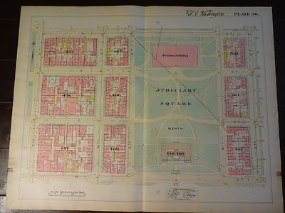
$7.00 Shipping Location: Rockville, United States Up for sale is a great. Large, antique map of a small set of blocks in N.W. DC. This map has property specific detail of the area between D Street and ... moreG Street and stretches from the 7th Street to 3rd Street. This is known as the Judiciary Square area of Northwest. The Judiciary Square Metro Station now sits on 4th Street between Area 531 and Area 532. The National Building Museum now sits where this map shows the Pension Building above Judiciary Square. The Verizon Center sits at 601 F Street and now takes up the entire block of Area 455. Interstate 395 now runs just to the east of 3rd Street and Area 532. The District of Columbia Court of Appeals is in the City Hall spot on this map. This map measures approximately 28 1/2 x 22 1/2 inches. Including the border area. Property specific detail. Map is in color. VERY RARE. This map is from the Real Estate Plat-Book of Washington. District of Columbia. Vol. 1. Comprising the entire North-West Section from the Original Plats of Squares& Subdivisions and Additions upon record in the office of the Surveyor of the City of Washington" Constructed under the direction of and published in 1892 by Griffith M. Hopkins, in Philadelphia, Pennsylvania. Maps this early and showing this much detail of Washington D.C. are VERY SCARCE. The map has fantastic coloring to it. Lots of color coding to represent various attributes(white/stone building. Pink/brick building, yellow/frame building, if it looks like an envelope/a stable or shed, and black& white dotted/green house etc. Map in generally good condition(not perfect but pretty nice condition) Some browning and small chips or creases at edges. Map is blank on the reverse side. There is a crease up the middle where it was originally bound. The map has some small tears and chips around the edges. A brown square stain can be found in the bottom of the right edge and the bottom of the left edge of the map. Caused by the original binding. There are some black scuff marks along the left edge. There are a few pencil marks le
Buy It Now
$6.95 Shipping Location: Silver Spring, United States COUNTY MAP OF VIRGINIA & WEST VIRGINIA. Title: County Map of Virginia and West Virginia. PLAN OF THE CITY OF WASHINGTON. Title: Plan of the City of Washington. ... moreThe New General Atlas was published until 1893.
Buy It Now
$5.00 Shipping Location: Santa Ana, United States This map is in excellent original condition without any flaws.
Buy It Now
$6.95 Shipping Location: Dover, United States Issued 1868, New York by Virtue, Yorston & Co. Engraved by W. Kemble. Mid 19th century color lithographed Civil War map. Virginia, Maryland, Delaware, ... moreand Part of Pennsylvania.
Buy It Now
Free Shipping Location: Iowa City, United States This color map ofMaryland & Delaware is dated 1907 on the face. Counties, County Seats,Cities; many Small Towns and Villages, Ports; Military Airfields ... moreand Forts; Rivers, Streams, and Lakes; and other topographical features are located on this map.
Buy It Now
$6.35 Shipping Location: Millis, United States Morrison’s Stranger’s Guide for Washington City. With numerous engravings and map.Published in Washington by W. H. & O. H. Morrison. J. F. Jarvis.GuidebookRed ... morestiff boards 52 page guidebook includes two rare fold-out maps21.5 x 16.5”Map 1: Bird’s Eye View of Washington DC Map 2: Map of the Cities of Washington and Georgetown, DC, 1876. Lavishly illustrated guidebook features steel and wood engravings throughoutPlease see photos for specific condition and content information
Buy It Now
$10.99 Shipping Location: Raleigh, United States Antique 1904 Sectional Map Of Prince Of Wales Island, Kasaan Bay, Clarence Straight, Cleveland Peninsula. This is from a 1904 copy of Alaskan Boundary ... moreTribunal Atlas Of Award book. From Alaskan Boundary Tribunal Atlas Of Award Book.
Buy It Now
$15.00 Shipping Location: Brooklyn, United States The map depicts the region from the Pacific Ocean to the Atlantic Ocean and from Canada to Panama. Signature Required. Highly detailed, myriad cities ... moreand towns are labeled throughout the eastern United States, including state capitals and Washington, D.C. States are shaded different colors to allow for easy differentiation.
Buy It Now
Free Shipping Location: Nampa, United States Ask The Watch.

Buy It Now
$4.99 Shipping Location: Fairview, United States Lake Erie Maps& Prints! An Authentic Antique Map: Not a Reproduction! Click Here for more US Coast Survey Maps Free Shipping on Purchases of 5 or ... moreMore Maps and Prints Description: It is an authentic steel engraved antique map published in the Report of the Superintendent of the United States Coast Survey during the Fiscal Year ending June 1881(Washington: Government Printing Office. 1883) A facsimile copy of the title page is included. The map is well documented in the title block area stating US. Coast Survey and dated 1881 or earlier. It is uncolored as originally issued. The map is not matted, mounted or framed, being sold as shown in the main pic. Size: The map image measures approximately 12 by 17 inches on a 13 by 19" page Condition: The map is in Good condition with overall tonal aging. Blank on the reverse with multiple folds as issued. It is basically as seen in the pic. There are a couple of minor creases at the ends of the folds and small hole at the fold intersection and some very minor dampstaining along one fold as seen, otherwise it is very well preserved on a strong flexible page that would frame up nicely, see the pics for more on condition. The pics are of the actual map being sold. Payment Details: We accept most major credit cards through Paypal and Ebay. Please ask if you have any questions about payment. International and New Bidders are welcomed and encouraged. Payment is expected within 7 days. After which Nonpaying Bidders will be reported to Ebay to recoup our listing fees. We are glad to save you shipping by combining multiple maps and prints based on the shipping cost of the largest item. International Customs and VAT Fees: It is the responsibility of the buyer to pay all Customs Taxes. VAT or other fees that may be due upon arrival. These fees vary greatly from country to country and ebay policy is that the buyer is responsible for their country's taxes and fees. Please consult your country's Customs Regulations for more details on your country, printed matter is duty
Buy It Now
Free Shipping Location: Iowa City, United States This color map ofMaryland and Delaware is dated 1891 on the face. Counties, County Seats,Cities; many Small Towns and Villages; Ports, Military Airfields ... moreand Forts; Rivers, Streams, and Lakes; and other topographical features are located on this map.
Buy It Now
$5.79 Shipping Location: Fairport, United States It appears to be a c1920 photo of the 1866 map. date of 1866 hand written in pencil. A nice find. I do not set rates and can’t afford to absorb these ... morecosts, being a small operation.
Buy It Now
$7.09 Shipping Location: Hanover, United States Selling an original 1950’s Nautical chart of Cape Canaveral to Bethel Shoal, Florida.Featured are: Sebastian, Roseland, Witer Beach, Wabasso, Micco, Valkaria, ... moreTurkey Creek, Melbourne, Merrit Island, Banana River and various rivers and creeks .Published in Washington DC by the US Coast and Geodetic Survey.Measurements: Paper 45” x 35”The map was originally folded in 4. Very good condition with excellent color. - see images.
Buy It Now
$6.00 Shipping Location: Columbus, United States This antique map is in Very Good condition, with bright hand coloring. The map shows light toning to the edges and light scattered foxing, and is held ... morein a clear, plastic, protective case. Baltimore, Annapolis, Dover, DC, Etc.
Buy It Now
Free Shipping Location: Monroeville, United States Date - 1890. Source - People’s Family Atlas of the World. FROM THE SOURCE/DATE LISTED.
Buy It Now
Free Shipping Location: New York, United States
Buy It Now
$4.69 Shipping Location: Greenacres, United States It is dated 1901 in the lower corner.
Buy It Now
$10.57 Shipping Location: Avondale, United States Engraved and printed by the United States Geological Survey [USGS], Washington, DC. Other light antique wear.
Buy It Now
Free Shipping Location: Monroeville, United States Date - 1898. Condition - Very Nice.
Buy It Now
$5.95 Shipping Location: Tulsa, United States This is an all original 1968 non-revised version Geological map that was available for sale from the United States Geological Survey in Washington, DC.
Buy It Now
$5.00 Shipping Location: Jacksonville, United States 1856 Antique LIthograph of the New Jail Design for the District of Columbia by Duval of Philadelphia, this map was part of a publication produced for ... morethe 34th congress of the United States. Height ~18".
Buy It Now
Free Shipping Location: Mechanicsville, United States CONSIDERING THIS IS 110 YEARS OLD IT IS IN BEAUTIFUL CONDITION. WOODROW WILSON WAS PRESIDENT WHEN THIS WAS PUBLISHED. THE POPULATION FOR DC WAS A LITTLE ... moreOVER 331,000. TOADY IT IS 712,816!
Buy It Now
$7.09 Shipping Location: Hanover, United States Selling an original 1950’s Original Nautical Chart or Map of East Cape to Mormon Key at the North to East Cape near Lake Ingraham at the South.Published ... morein Washington DC by the US Coast and Geodetic Survey. Measurements: Paper 35” x 44”The map was originally folded in 4. Very good condition with excellent color - see images.
Buy It Now
$5.00 Shipping Location: Laurel, United States During the Civil War, Cram served under General William Tecumseh Sherman and participated in his March to the Sea. One of their most famous products was ... morethe Unrivaled Atlas of the World, in print from the 1880s to the 1950s.
Buy It Now
$9.95 Shipping Location: Twinsburg, United States Nice set for US History lovers!
Buy It Now
$5.00 Shipping Location: Jacksonville, United States This print was removed form an 1869 Johnson's Atlas and is in very good condition. This fine D.C. US Capitol is in very good condition with normal wear(staining/browning) ... moreyou would typically see on a map of this age.
Buy It Now
$3.25 Shipping Location: Winter Springs, United States With gorgeous delicate period handcoloring, this is before color printing. Morse was a highly regarded and important mapmaker of this period. The size ... moreof the map is 9.5" by 12". FREE scheduling, supersized images.
Buy It Now
$10.00 Shipping Location: Rockville, United States Nicely colored. A tear at far left side. Light browning.
Buy It Now
$4.59 Shipping Location: Greenacres, United States There's an inset of the Aleutian Islands, locating Attu and Kiska, seized by the Japanese in June 1942, just a month after this map was issued. The map ... moreis drawn on a scale of 1:12,000,000 and unfolds to a generous 32½" x 26½".
Buy It Now
$12.00 Shipping Location: Rockport, United States This is a double sheet. I HAVE OTHER PLATES WHICH WILL BE LISTED LATER. I DO NOT HAVE THE INDEX. DATE: 1888. CONDITION: ATLAS WAS USED AND DISBOUND WHEN ... moreI FOUND IT. Fantastic detail shown on this map.
$10.00 Shipping Location: Delray Beach, United States Inset of Washington D,C. Interesting and very detailed county map. Image area is 15.5" w by 12.5" h. including decorative border. Original hand colored ... moreengraving as issued. See photos.
$9.99 Shipping Location: Pompano Beach, United States AND A 1955 MCGRAW, NEW YORK QUADRANGLE 7.5 MINUTE SERIES TOPOGRAPHICAL ", ALL FROM THE US GEOLOGICAL SURVEY, WASHINGTON DC.

Buy It Now
$15.00 Shipping Location: Pacifica, United States RARE* ANTIQUE 1862 MAP of WASHINGTON. DC& GEORGETOWN 150 years old HIGHLY DETAILED HAND-COLORED CIVIL WAR ERA Size: 18" x 14" single folio ... moreInsets: The Capitol Building• Washington Monument• Smithsonian Institution Notes regarding Insets: The map was published in Johnson's atlases in 1860-62. At that time the Capitol building construction hadn't reached the"finished" state depicted on this map. Plus. The Statue of Freedom wasn't placed atop the dome until 1863, so artistic license can only explain the little figure holding a tall spear(or whatever) depicted here. At the time. The Washington Monument was only a stump of its future self, sitting on boggy land near the Potomac River. It wasn't finished until 1884. And obviously the surrounding colonnade. Depicted as originally planned, was never built. Map is from A.J. Johnson's New Illustrated Family Atlas of the World With Descriptions Compiled. Drawn, and Engraved under the supervision of J.H. Colton& A.J. Johnson New York: Johnson& Browning 1862 saw the transition of Johnson& Browning to Johnson& Ward. Maps are labeled Johnson& Ward. GO HERE FOR HISTORICAL DETAILS ABOUT THE PRODUCTION OF THIS ATLAS AND VARIATIONS AS THEY OCCURRED OVER THE YEARS: I've included photos of the atlas this map came from for reference only(not included in auction and labeled as such) CONDITION: Consult"Condition Description" herein(no other specific defects) and look at photos carefully before making your purchase. Map will be shipped in a sturdy new mailing tube 21" x 3" diameter. PayPal ONLY accepted as payment. Due immediately using Buy-It-Now. No refunds. Returns or exchanges. Please consult photos and descriptions carefully before making your purchase. THANKS KINDLY!
Buy It Now
$9.39 Shipping Condition: Very Good Location: LEAMINGTON SPA, United Kingdom The National Geographic Society, Washington D.C. However, we are not experts.
Buy It Now
$50.35 Shipping Location: Atlanta, United States
Buy It Now
$9.99 Shipping Location: Canaan, United States Good Luck!
Buy It Now
$7.09 Shipping Location: Hanover, United States Selling an original 1950’s Original Nautical Chart or Map of the South Coast of Newfoundland.Areas of Interest: Great Miquelon, Little Miquelon Isalnds, ... morethe areas around Bay Despoir, Hermitage and Fortune Bay, Pacentia Bay and Merasheen Islands. Published in Hydrographic Office, Washington DC.Measurements: Paper 30” x 50”The map was originally folded in 4. Very good condition with excellent color - see images.

Buy It Now
$7.00 Shipping Location: Rockville, United States Up for sale is a great. Large, antique map of a small set of blocks in N.W. DC. This map has property specific detail of the area between K Street and ... moreN Street and stretches from the 7th Street to 3rd Street. This area includes Mount Vernon Square,and the upper part of Chinatown. The Convention Center sits at the corner of 7th and NW Avenue, just to the left of this map. Interstate 395 now runs up Area 526 and 525. The Police Station in area 481 has been replaced by apartment buildings. Madison Street in Area 448 is now called Emmanuel Court. Most of the other buildings are now residential. The"Nothern Liberty Market Co. Lot 108 in the bottom middle of the map, is now residential buildings with shop on the street level. This map measures approximately 28 1/2 x 22 1/2 inches. Including the border area. Property specific detail. Map is in color. VERY RARE. This map is from the Real Estate Plat-Book of Washington. District of Columbia. Vol. 1. Comprising the entire North-West Section from the Original Plats of Squares& Subdivisions and Additions upon record in the office of the Surveyor of the City of Washington" Constructed under the direction of and published in 1892 by Griffith M. Hopkins, in Philadelphia, Pennsylvania. Maps this early and showing this much detail of Washington D.C. are VERY SCARCE. The map has fantastic coloring to it. Lots of color coding to represent various attributes(white/stone building. Pink/brick building, yellow/frame building, if it looks like an envelope/a stable or shed, and black& white dotted/green house etc. Map in generally good condition(not perfect but pretty nice condition) Some browning and small chips or creases at edges. Map is blank on the reverse side. There is a crease up the middle where it was originally bound. The map has some small tears and chips around the edges. A brown square stain can be found in the bottom of the right edge and the bottom of the left edge of the map. Caused by the original binding. There are some black scuff marks along the lef
Buy It Now
$6.95 Shipping Location: Dover, United States Block Island Sound and Approaches. This old map was printed on thick, heavy paper, not the thin tissue paper used by the USCGS in the 19th century.
|
|
|
In
|
1901 Rand McNally Pictorial Guide of Washington, DC & large map
1901 Rand McNally Pictorial Guide of Washington. DC& large map For auction is a copy of"Rand. McNally& Company's Pictorial Guide of Washington and Environs" It is dated 1901. The book contains complete descriptions of the Capitol. Library of Congress, White House, government Departments, Mount Vernon, Arlington Cemetery, and other significant tourist destinations in the District of Columbia and suburbs. It is heavily illustrated. With detailed descriptions of the various features. There is a great fold-out map showing Washington and its attractions. As well as advertisements for hotels. Railroads, and retail establishments. This publication. Which measures appx 8 1/2 x 5 3/4 inches, contains 204 pages. The cover is a medium-weight cardstock. And the content pages are a semi-glossy paperstock. There is a great color map ... morethat folds out to measure appx 27x21 inches; it includes street names. While this publication is over 110 years old. It is in good condition. There is no writing or markings on either the text or the map. There are no rips or tears. Either. The cover shows wear, and the binding edge is deteriorating, but all pages are now firmly in place. A fantastic old booklet for the library of the Washington fan. Click Images to Enlarge I will send the winning bid an Invoice at the end of the action. Payment by PayPal is due within 3 business days following the end of the auction. First-class shipping cost is cited. If you wish additional shipping services. Such as Priority Mail or Express Mail, contact me. Also, please contact me in advance of bidding if you are an international buyer for shipping options to your country. inkfrog terapeak. I000000. InkFrog Analytics.
|
|
|
DC HEROCLIX - BATCAVE INDOOR A / STAR LABS MAP B 2 SIDED MAP - WIZKIDS
This item is DC HEROCLIX- BATCAVE INDOOR A/ STAR LABS MAP B 2 SIDED MAP- WIZKIDS USED- The map is used. The condition has original folds and some minor creases and no tears from storage and no tack holes. Please email me with any questions. Shipping in the states is $4.50 I DO COMBINE SHIPPING! I DO SHIP INTERNATIONAL. PLEASE EMAIL FOR RATES. Thank you for viewing. di,RcmdId ViewItemDescV4,RlogId p4%60bo7%60jtb9%3Fuk%601d72f%2Bishhov%3C%3Edi-1477e53e406-0x101-
|
|
|
DC HEROCLIX - JUSTICE LEAGUE WATCHTOWER A / METROPOLIS MAP B 2 SIDED MAP-WIZKIDS
This item is DC HEROCLIX- JUSTICE LEAGUE WATCHTOWER A/ METROPOLIS MAP B 2 SIDED MAP-WIZKIDS USED- The map is used. The condition has original folds and some minor creases and no tears from storage and no tack holes. Please email me with any questions. Shipping in the states is $4.50 I DO COMBINE SHIPPING! I DO SHIP INTERNATIONAL. PLEASE EMAIL FOR RATES. Thank you for viewing.
|
|
|
1866 Colton Map - Virginia & West VA - Richmond Norfolk Plans - Washington DC
Lake Erie Maps& Prints! An Authentic Antique Map: Not a Modern Reproduction! See Our Ebay Store for other! Free Shipping on Purchases of 5 or More Maps and Prints Description: It is an original engraved antique map over 147 years old with original hand coloring as issued. It is from Colton's General Atlas. Published in New York by the Colton& Co. 1866. Thee is a copyright date of 1855 by J.H. Colton in small print under the title area. A facsimile copy of the title page will also be included for authenticity. The map is not mounted, matted nor framed, being sold as a single elephant size folio sheet as shown in the main pic. Size: The map image measures approximately 12 1/2 by 15 1/2 inches(32x39cm) on a 15 1/2 by 18 1/2" 37x44cm) page with a margin all around for framing as seen in the pic. Condition: The map is in Fair ... moreor better condition with overall light tonal aging and original hand coloring as issued. It is basically as seen in the pics with some damp staining around the margin. And a short edgetear, otherwise the map image area is very clean and would frame up well. The pics are of the actual map. Payment Details: We accept most major credit cards through Paypal and Ebay. Please ask if you have any questions about payment. International and New Bidders are welcomed and encouraged. Payment is expected within 7 days. After which Nonpaying Bidders will be reported to Ebay to recoup our listing fees. Save on Shipping: We only charge one shipping fee based on the largest map or print with multiple items shipped along with it for no extra costs. Purchase 5 or more maps or prints and receive Free First Class shipping in USA or First Class International elsewhere in the world. Although registration may be required on shipments of high value. International Customs and VAT Fees: It is the responsibility of the buyer to pay all Customs Taxes. VAT or other fees that may be due upon arrival. These fees vary greatly from country to country and ebay policy is that the buyer is responsible for their coun
|
|
|
Vintage Triple A map of Washington DC and Suburbs Circa 1940's
SHIPPING: FREE DOMESTIC SHIPPING ON INVOICES THAT TOTALS $30.00 OR MORE. I DO COMBINE MULTIPLE PURCHASES WHEN I SEND YOU A INVOICE. PURCHASES OVER 5 DAYS WILL WILL BE COMBINED ON THE INVOICE. CONTACT ME WHEN YOU WILL BE BIDDING OVER MORE THEN ONE DAYS LISTINGS. PLEASE WAIT FOR MY INVOICE SHOWING THE CORRECTED SHIPPING FEE. Shipping(First-Class Package) to all US locations will cost $1.50. Shipping(First-Class Registered Mail Letter) to all locations will cost $12.50. I will ship within 24 hours of receipt of payment. If I have blocked your country you can contact me if you wish to bid! PAYMENT POLICY: PAYMENTS ARE DUE WITHIN 7 DAYS OF AUCTION CLOSE. IF NOT PAID BY THE 8TH DAY I WILL FILE UNPAID CLAIM. RETURN POLICY: BUYER IS RESPONSIBLE FOR THE RETURN SHIPPING COST. THE REFUND(EXCLUDING THE SHIPPING COAST) WILL BE SENT BACK TO THE PAYPAL ... moreACCOUNT AFTER RETURNED IS RECEIVED. EXCEPTIONS TO RETURN AND REFUND ITEMS DAMAGED DURING SHIPMENT BY POSTAL AUTHORITIES WILL NOT QUALIFY FOR REFUND/RETURN. ITEMS PROPERLY IDENTIFIED WILL NOT QUALITY FOR REFUND/RETURN. BID CANCELLATION: I RESERVE THE RIGHT TO CANCEL A LISTING AT ANYTIME. OGALLALA Be sure to add me to your! Check out my! Powered by The free listing tool. List your items fast and easy and manage your active items. RcmdId ViewItemDescV4,RlogId p4%60bo7%60jtb9%3Feog4d71f%2B%3F4f%3E-14786a590b8-0x110-
|
|
|
United Airlines DC-3 era packet of 20 w/'41TT/pcs/brocs/tkjkt-tks/map/sungl/log+
see above ag6 2.RcmdId ViewItemDescV4,RlogId p4%60bo7%60jtb9%3Fuk.rp73%28c%3Eag6%3E2-1478a12f388-0x114-
|
|
|
OK OR 1956 XL OKLAHOMA RAILROAD MAP. BM&E FW&DC KO&G ON TO&E WV. OREGON 1950s
Combined shipping is offered in the shopping cart. This is the LARGE FORMAT map. 10" x 14" sheet with a map in the border of 9" x 12.5" Same price as the smaller version with just a bit more postage due to size and weight. Single sheet. Oklahoma on one side. Oregon with Portland/ Salem inset maps on the other. Not a reproduction or copy. You will receive the ORIGINAL map in the photos. I do not use stock photos. All railroads are numbered per accompanying list. Making possible quick and accurate identification of each line. Includes many of the old lines that were abandoned or merged long ago. Carefully removed from 1956 atlas. Quality atlas type non sheen paper. Brilliant multi-color detail. Overall fine. Typical margin toning. Impressive for 58 years old. Zoom the photos. More Oklahoma maps here: More Oregon maps here: ... moreSearch my listings for your state: Indiana residents add 7% sales tax. Shipped flat with cardboard.fast. Returns only if item is not as described. The photos are part of the description. INV: US30.56-4XL.147.148
|
|
|
ANTIQUE French Map Of WASHINGTON DC United States CIRCA 1827 Bermuda NO RESERVE
ANTIQUE French Map Of WASHINGTON DC United States CIRCA 1827 Bermuda NO RESERVE. Call us at 615-983-6460 for more information Item Description: Large. Antique French Map. Not dated, but has pencil date of 1827. Map has the Washington DC land and water area at the top, left. A description of the land is given as well. A small inset of Bermuda is at the right. Map has some edge wear. Measures about 21.5 x 26.5 inches. Shipping Policy: RETURN POLICY: We ship everyday domestic and international via USPS or UPS. Most items are packaged in a box with bubble wrap and other packing materials for maximum protection. Please feel free to contact us with any questions or prefer to use a different carrier. We can accommodate your special needs! We do offer combined shipping on items. If you are bidding on multiple items. Contact us so we know that is ... morewhat you want to do. If after you have received your item you desire to return it. Please contact a member of our staff via phone, email, or eBay message IMMEDIATELY. We request after you contact us that you return the item within 14 days. We will issue the refund by method of payment or by PayPal. We will provide you with the information needed to process the return and send it back to us via UPS to ensure it is returned to us as quickly and safely as possible. WE ACCEPT PAYPAL AND ALL MAJOR CREDIT CARDS DIRECT! As with all of our items. We stand behind what we sell. We would like to take a moment to remind you that an eBay auction is a buying experience and not a"buy, use and return" experience. Please ask questions before you bid if you have them. Please bid based upon what is actually DESCRIBED and SHOWN in our photographs. All items are sold"AS IS" unless you find our written description and/or photos do not match what you purchased. inkfrog terapeak. I000000. InkFrog Analytics.
|
|
|
1930's Amoco Gas Virginia West Virginia Maryland Delaware Washington DC Road Map
VINTAGE 1930's AMOCO GAS VIRGINIA WEST VIRGINIA MARYLAND DELAWARE WASHINGTON DC ROAD MAP American Oil Company This Vintage road map is a great gas and oil advertising souvenir. The item is in used overall condition with normal edge and fold wear. There are some point tears where 4 corners come together and one panel edge tear. I have taken a picture of the item so you can make your own judgment of its condition and bid accordingly. The item will be protectively shipped. Please feel free to ask me any questions you desire. Winning bidder will be contacted promptly after end of auction and payment is expected within 4 days. I accept Paypal as well as whatever other payment methods are still allowed by eBay policies at the time of purchase. Foreign bidders must pay using Paypal. Shipping and handling is $3.95 within the United States and ... more$5.95 to other countries. This includes delivery confirmation tracking for US shipments. Non-US customers MUST accept a USPS postal receipt as proof of mailing. RcmdId ViewItemDescV4,RlogId p4%60bo7%60jtb9%3Fuk.rp*05e54c%3E-1478fcd61d9-0x112-
|
|
|
1950 Esso Washington DC Vintage Road Map
1950 Esso Washington DC Vintage Road Map Great vintage map of Washington DC. Map show some signs of use and is in overall good condition. A couple of small tears on seams and a folded corner.
|
|
|
1950 ESSO Road Map WASHINGTON DC National Capital Sesquicentennial Alexandria
1950 ESSO Road Map WASHINGTON DC National Capital Sesquicentennial Alexandria Handsome fold-out Esso road map of the District of Columbia and vicinity. Printed more than 64 years ago. This map opens up to 25" x 24" and has great detail on old street and highway alignments. With cartography by the General Drafting Company. The coverage area extends from Lorton. Virginia, to Beltsville, Maryland, including Alexandria, Arlington, Greenbelt, Silver Spring, Takoma Park, Bethesda, Chevy Chase, Wheaton, College Park, Vienna, Fairfax, Hyattsville, Mount Vernon, and more. On the reverse side there is a street map of downtown Washington, D.C. with a key to temporary government buildings. The front cover artwork shows the Washington Monument. With a portrait of our first president. There is an inset of the historic landmarks of Alexandria, ... moreand the map commemorates the National Capital Sesquicentennial(1800-1950) The map was distributed by the Standard Oil Company of New Jersey to promote its Esso brand. And it is dated in the legend. The code number in the lower margin is 1249. Condition: This map is in very good condition. Bright and clean, with no rips or tears. There is a neat rubber-stamp imprint on the rear cover from an Esso gas station at 10th& Maine Avenue SW— an area now the site of Banneker Park. Circle and Overlook. Here's a scan of the map opened up: Buy with confidence! We are always happy to combine shipping on the purchase of multiple items. And everything we sell comes with our unconditional. Money-back guarantee. SHIPPING: We gladly ship anywhere in the World. And we use sturdy, professional packing materials to assure safe delivery. The shipping charges are as follows: Within the United States. Including Alaska, Hawaii, and APO addresses: $2.89 To Canada or Mexico: $8.79 To all other international destinations: $12.99(These charges reflect rates set by the United States Postal Service for domestic and international delivery. We will appreciate your prompt payment for this item. If you nee
|
|
|
WORLD of KRYPTON Map, 27" x 21", 1970's Fold Out Map, SUPERMAN - DC Comics.
WORLD of KRYPTON Map. 27" x 21" 1970's Fold Out Map, SUPERMAN- DC Comics- Small tear under letter"R" of KRYPTON and stains on back of map.SEE PHOTOS) These are actual scans/photos of the item up for sale;I never use stock photos or scans for any items.Buy in confidence as I offer a 14 day money back guarantee if not 100% satisfied. Thank you! FREE SHIPPING to CANADA and the U.S. INTERNATIONAL Shipping $5.00.
|
|
|
1917 MAP OF MARYLAND DELAWARE DC WASHINGTON / CONNECTICUT ON REVERSE SIDE
1917 MAP OF MARYLAND DELAWARE DC WASHINGTON/ CONNECTICUT ON REVERSE SIDE This original antique map gives you an opportunity to examine in exquisite detail a piece of history. If you are interested in the past of this country and its people or have a desire to study where your family may have come from. Then this map gives you a rare look as the area was about 95 years ago. Once matted and framed, this map would make a perfect gift for a family member or friend they'll cherish forever. Origin of the map: New Standard Atlas of the United States" Published by National Map Company, Indianapolis- New York, USA. Date of issue: 1917 Size: The sheet measures 15" x 11 1/4" 38 x 29 cm) S/H: The map will be shipped by Air Mail. The shipping charge is: USA- 8.00 USD. Canada/World- 9.00 USD. The price includes the insurance and a strong, ... morecardboard tube with plastic plugs. Attention! There is no additional shipping charge for multiple purchases! Pay me securely with any major credit card through PayPal! Payment methods: US/Canada Buyers: Paypal. International Buyers: Paypal. Click Here. Double your traffic. Get Vendio Gallery- Now FREE!
|
|
|
SDCC 2014 DC Comics Multiverse Map Grant Morrison NEW Multiversity Promo RARE
Super New. Super Hot, And Super Rare! Huge 24 x 30 inches! Mint Condition! Only Unfolded Once For Photo. Bid Now Wont Last and These Are Rare! Free Super Fast Shipping!
|
|
|
VINTAGE LINEN BACKED BAIST'S MAP WASHINGTON DC PLAN 6 DUPONT CIRCLE
THE MAP IS IN GREAT SHAPE. THERE ARE SMALL TAB MARKS ON BOTH ENDS. 23" X 31" THERE IS A CREASE THAT HAS BEEN STRAIGHTENED OUT. DUPONT CIRCLE. 21ST ST. RcmdId ViewItemDescV4,RlogId p4%60bo7%60jtb9%3Fvo%7B%3Dd70f%2Bf52%3E-147990fd52c-0x111-
|
|
|
Texaco Gasoline Road Map Baltimore & Washington DC 1956
Scant use. If any. Dimensions given. If any, are approximate. Condition as shown. Defects not visible in scan[s] are described. Item is complete as issued unless otherwise stated. NO facsimiles, copies, reprints or reproductions unless specifically stated in description above. Pictures show actual item, never a stock image. SKU: 1401701) All items are originals; no facsimiles. Copies or reproductions, unless specifically noted. All scans or photographs shown are of the actual items you will receive. We NEVER use stock images. PLEASE NOTE: this seller accepts ONLY payments made through PayPal. Please do not request alternatives. Please do not unilaterally send other forms of payment as we cannot accept them. QUESTIONS about an item must be received no later than 5 PM Eastern Time on the day the item closes. Most of our items close between ... more10 PM and Midnight Eastern Time. Please be sure to reference the eBay item number in your inquiry. See what's for sale now in our ebaY Store! Just CLICK on the Frog. FREE standard shipping with DELIVERY CONFIRMATION& TRACKING BY USPS to all United States destinations including possessions anywhere in the world. For orders valued $100 and above. We insure them at our expense. You can follow your item on its way to you at We ship promptly using most efficient rate. So all shipped items are guaranteed to be returned to us by the USPS if not deliverable as addressed. Undeliverable items returned to us for incorrect address, moved-left-no-forwarding, etc. may require additional payment for redelivery. You will be notified. Due to an unacceptably high number of delays and non-delivery of items in other lands resulting in disgruntlement and loss of revenue& merchandise. We no longer offer our goods to buyers outside the United States& its possessions. A combination of increased postal security. The requirement by the USPS for Customs Declarations on all packages& packets, and the lack of recognition of that Customs Declaration as Proof of Mailing by the powers that b
|
|
|
1947 Pan Am/American~Grace~ Airlines DC-6 Route Map Ad : Vintage Advertising
Vintage 1940's Magazine Advertisement Condition Scale: Fine This collectible magazine a dvertisement is about: 8" X 11 1/4" 20 X 29 cm) Magazine advertisements are a great way to display your interests& enhance the theme of any room. It will look awesome in your home or office. Unique eco-friendly gift idea! Shipped flat in a poly protective sleeve with backer Removable for immediate framing Shop at my eBay Store We Combine All Orders
|
|
|
1918 map of Public buildings, Washington, DC Washington, the Mall and vicinity,
Frame not included) Map Description: 1918 Washington. The Mall and vicinity, public buildings occupied by various government activities: 1917/ prepared by the Public Buildings Commission; made under the direction of Colonel W.W. Harts and Colonel C.S. Ridley; James G. Langdon, city planning designer; drawn by K. Hilding Beij. Size: Approximately 2 foot x 18 inches. 61cm x 46cm) Archival Quality Reproduction Close up of Map Quality: Shipping: Tracking Number& Insurance: included for free for all domestic orders! Packaging: heavy duty poster tube. END FOOTER/
|
|
|
AA American Airlines DC-7 model instructions and System map
coupon cut out and some dry glue on the instructions. very nice map!
|
|
|
1999 DE-DC-MD-VA Map (AAA)
This is a 1999 Delaware. District of Columbia, Maryland, Virginia Map Mapped. Edited and Published by the American Automobile Association Copyright 1999 Picture shown on front cover is Mabry Mill. Blue Ridge Parkway, VA This map is in good condition One side of map shows Delaware. District of Columbia, Maryland and a portion of Virginia. Also shows portions of adjacent states: Pennsylvania. New Jersey and West Virginia. Contains inset maps of Washington. D.C. Vicinity, Baltimore& Vicinity, Annapolis, MD; Wilmington, DE; Dover, DE. Index to the three states. Driving Distance Chart and Guide to Toll Facilities are also shown. Other side of the map is the Virginia. Shows portions of North Carolina. Tennessee, Kentucky, West Virginia, Maryland and Delaware. Includes an Index to Cities and Towns. Toll Facilities Guide and a mileage between ... morecities chart. Contains inset maps of Richmond-Petersburg Area. Hampton Roads Area, Downtown Norfolk, Roanoke, Danville, Lynchburg, Charlottesville& Colonial National Historical Park. Map Size: 34” x 24" approximately. This is a folded map Map is in good condition. Great Historic resource. Shipping combined on multiple purchases of similiar type maps(folded maps) Thanks for looking! Happy Ebaying! On Jan-28-03 at 10:49:45 PST. Seller added the following information: Pay me securely with any major credit card through PayPal! Posted with
|
|
|
Vintage WASHINGTON DC Cartoon Map 1938 RUTH TAYLOR ORIGINAL LITHOGRAPH
RUTH TAYLOR(WHITE) Caricature Map- Lithographed in Six(6) Colors in 1938- Text by Frank Taylor These maps are hard to beat for just pure fun! Even though there are politically incorrect depictions of African. Native, and Asian Americans in these maps, they are simply a part of our collective history. warts and all! I love these maps, and keep a complete set for my own collection. From a printing technique and quality perspective, they are of the highest quality available for the time. SIZE: image about 8 1/2" x 11 1/2" Paper size 9 1/4" x 12 1/2" CONDITION: Excellent. Please use photos to determine your own sense of condition. If you have questions about condition. Please message me. I include a photocopy of the accompanying text page for each map. Since the text on the reverse of each map is for the NEXT map. The watermark"dotyprints" ... morewill not appear on the hard copy that you will receive in the shipment. SHIPPING: Domestic FREE All maps will be mailed flat in a cardboard mailer. International $13.25 Arkansas residents will have 8.5% Sales Tax added. Powered by The free listing tool. List your items fast and easy and manage your active items.
|
|
|
Map of Suburban Washington DC circa 1964
Map of Suburban Washington DC. Circa 1964. This map is in excellent condition for its age. Published by the National Geographic Society for National Geographic Magazine. Probably one of the first maps to show the Beltway around Washington, DC.
|
|
|
DC Promo Poster Map Of The Multiverse 30"x24" Multiversity Grant Morrison
Measures 30" x 24" Never displayed. Will be shipped flat These were distributed one per store Shipping within the U.S. is free When making multiple purchases. Please wait for an invoice before paying Outside the US. Contact me with any shipping questions I offer combined shipping based on total weight of package E-mail me with any questions Payment can be made via Paypal and must be recieved within 4 days of auction end unless prior arrangements have been made Check out my other auctions! Visit my eBay store!
|
|
|
Prince's Color Picture Book of Washington DC Capital Pentagon Monument Tour Map
You are bidding on a copy of"Prince's Color Picture Book of Washington. This 26-page booklet has color pictures and descriptions of all the attractions to see in the nation's capital. Including the White House, Lincoln Memorial, Jefferson Memorial, Washington Monument and more. The booklet is from the'80s and is in perfect condition. I accept checks or PayPal. Shipping and handling is FREE. Please e-mail me if you have ANY questions. Thanks for looking and good luck! 336.RcmdId ViewItemDescV4,RlogId p4%60bo7%60jtb9%3Fvo%7B%3Dd70f%2B%3E336-147a7806143-0x10d-
|
|
|
VINTAGE PENNSYLVANIA Railroad TOUR BOOKLET AND MAP GUIDE TO WASHINGTON DC
VINTAGE PENNSYLVANIA Railroad TOUR BOOKLET AND MAP GUIDE TO WASHINGTON DC GREAT SHAPE NO STAPLES TO BOOK IT MEASURES 6 1/2 X 4 1/4 THE BOOK FROM THERE FIGURE OUT THE MAP SEE MY OTHER PRR RAILROAD ITEMS
|
|
|
1923 Royal Blue Line Motor Tours - Washington,DC Map and Guide
19 pg. guide compliments of The Kern Hotel.
|
|
|
Lot of DC Marval Heroclix Figures 200+ Figures Cards Disks Map Super Rare
A huge lot of Heroclix in MOSTLY EXCELLENT condition. Many Rares and Superares- Starters items such as Twisters Cards Pawns ETC- What you see is what you get. Many figures- Around 200 total pieces FREE SHIPPING Messege me with questions
|
|
|
Vintage Sinclair Map Washington DC 1950's
You are bidding on a used Sinclair gasoline map from Indiana. It is from the 1950's. Folded it measures 9" x 4" It is in good condition. Has a small tear on the front cover. Has edge wear and has yellowed with age. Winning bidder to pay $2.00 for shipping First Class Mail.I have other maps for sale this week and will combine to save on shipping. Please ask any questions before the last day of auction. I am not on my computer 24/7. I do not sell out of the United States. No exceptions. I will ship next business day after cleared payment is received. Powered by The free listing tool. List your items fast and easy and manage your active items.
|
|
|
BALTIMORE & OHIO RAILROAD 1958 PICTORIAL TRAVEL GUIDE & MAP WASHINGTON DC B&O
Here you have a wonderful bit of VINTAGE RAILROAD MEMORABILIA! Please.SEE THE SCAN! This is the 1958 BOOKLET“PICTORIAL TRAVEL GUIDE TO WASHINGTON: BALTIMORE& OHIO RAILROAD” This beautiful booklet has 52 pages of photos and text about the sites of DC. THIS INCLUDES A FOLD-OUT MAP OF THE DC INNER CITY. The back cover has the B&O symbol and a route map from New York to St Louis& Chicago. This is in GORGEOUS CONDITION and it’s a tough find! This is a great piece FOR THE COLLECTOR! Take it home with you! GOOD LUCK! Please Check Out My Ebay Store for more great memorabilia! I am happy to send this to any country. 1st class air postage will be charged… More excellent packaging and free shipping here in the United States! THANKS! boRR1958WASHINGTONguide Powered by The free listing tool. List your items fast and easy and manage your active ... moreitems.
|
|
|
1959-60 AAA Washington, DC/Suburban Maryland Vintage Road Map /Nice Cover!
Vintage AAA road map in excellent condition.
|
|
|
1969 Phillips 66 Washington, DC Vintage Road Map
Vintage Oil Company road map in excellent condition with some neatly done writing on the cover.
|
|
|
HTF Deco USA Capitol Map Washington DC Souvenir Syroco Wood Book Ends Bookends
Scroll down for more photos/ more views below description Hard To Find Art Deco style/era United States Capitol/U.S.A. map outline(with backing flag bunting and arrow background detail) souvenir book ends by the(old label) Syroco Wood Company. brand name-is actually a composite material made from wood pieces/ lookd like solid wood) I suspect by the style and label font that this pair was made in the 1940s. Molded into the fronts in 3-D relief are the aforementioned American classics. Plus great detail decoration to the edges and base"proscenium" style base. Each stands about 6.25" tall, around 4 38th in. side to side, and the part with the tab that slips under the books is around 3.25" They have a felt finish on the bottom. In nice looking shape for their age, with a few dings/ edge wear attesting to their authenticity/age. ... moreGreat for the SyrocoWood collector, bookend fan, Washington D.C. souvenir collection, US Capitol items, or anyone who enjoys patriotic historical memorabilia. We are listing another art deco Syroco Wood type book ends featuring an antelope. And other vintage Syrco items. We are also listing a darling Japan made 50s Bambi type fawn pair of bookends, a souvenir from Camp LaRue, Nest Lake, Spicer, Minn. Please scroll down for more photos. Our pictures are the major portion of our description-please view them carefully! Due to ebay's refund requirements that allow way too much time to pass before asking for a refund on fragile. Often one of a kind, vintage/ antique items, we no longer offer returns as a general policy, but if you find the item to be different than described/ or find a problem within three days of receiving your item, please contact us directly via"my ebay" as we are always willing to work with buyers to come to a mutually satisfactory outcome for all. Be sure to save all packaging if there is shipping damage/ or if item is to be returned, pending our approval. We are collectors/ sellers of antiques and collectibles so our items all come from estat
|
|
|
1863 Civil War map: Washington, DC District of Columbia and the seat of war on t
Frame not included) Map Description: 1863 map District of Columbia and the seat of war on the Potomac. Shows cities of Washington and Alexandria in foreground. Includes index of military positions with regiment names. Low angle birds eye view. Size: Approximately 2 foot x 18 inches. 61cm x 46cm) Archival Quality Reproduction Close up of Map Quality: Shipping: Tracking Number& Insurance included with all domestic orders Packaging: heavy duty poster tube. END FOOTER/
|
|
|
1953 AMOCO American Oil Road Map WASHINGTON DC Alexandria Chevy Chase Georgetown
1953 AMOCO American Oil Road Map WASHINGTON DC Alexandria Chevy Chase Georgetown Handsome fold-out Amoco road map of Washington. D.C. and vicinity, printed more than 61 years ago. The map opens to 18" x 29" and has great detail on old street and highway alignments. With cartography by Rand McNally. The coverage area extends from Kensington, Maryland to Mount Vernon, Virginia, including Takoma Park, Arlington, Chevy Chase, Silver Spring, Beltville, Cabin John, Falls Church, and Alexandria. A small inset shows truck routes through the city. There is a street plan of central Washington on the reverse side. Between Georgetown and Brentwood Park, including Rosslyn and Fort Lesley McNair. The map was distributed by the American Oil Company in 1953 to promote its Permalube and Amoco brands. And it is dated by the code number in the lower ... moremargin: 3-453681-5. Condition: This map is in very good. Lightly used condition, with some faint toning on the back cover and no rips. Tears, or writing. Buy with confidence! We are always happy to combine shipping on the purchase of multiple items. And everything we sell comes with our unconditional. Money-back guarantee. SHIPPING: We gladly ship anywhere in the World. And we use sturdy, professional packing materials to assure safe delivery. The shipping charges are as follows: Within the United States. Including Alaska, Hawaii, and APO addresses: $2.89 To Canada or Mexico: $8.79 To all other international destinations: $12.99(These charges reflect rates set by the United States Postal Service for domestic and international delivery. We will appreciate your prompt payment for this item. If you need more time or have any other questions about making your payment. Or if you may desire any special services, such as overnight delivery, please contact us. Florida residents add 6.5% sales tax. Be sure to check our auction listings on eBay for other antique and collectible maps and ephemera. Simply click on the link below. Many of the items offered can be combined with this purchas
|
|
|
1952 AMOCO American Oil Road Map WASHINGTON DC Alexandria Chevy Chase Georgetown
1952 AMOCO American Oil Road Map WASHINGTON DC Alexandria Chevy Chase Georgetown Handsome fold-out Amoco road map of Washington. D.C. and vicinity, printed more than 62 years ago. The map opens to 18" x 29" and has great detail on old street and highway alignments. With cartography by Rand McNally. The coverage area on the regional map extends from Silver Spring. Maryland to Mount Vernon, Virginia, including Takoma Park, Clarendon, Chevy Chase, Hyattsville, Cabin John, Falls Church, and Alexandria. There is a street plan of central Washington on the reverse side. Between Georgetown and Brentwood Park, including Rosslyn, Fort Lesley McNair, and the Tourist Camp in East Potomac Park. A small inset shows truck routes through the city. The map was distributed by the American Oil Company in 1952 to promote its Amoco brand. And it is ... moredated by the code number in the lower margin: 2-453681-4. Condition: This map is in very good. Lightly used condition, with a couple of tiny spots on the cover and no rips. Tears, or writing. Buy with confidence! We are always happy to combine shipping on the purchase of multiple items. And everything we sell comes with our unconditional. Money-back guarantee. SHIPPING: We gladly ship anywhere in the World. And we use sturdy, professional packing materials to assure safe delivery. The shipping charges are as follows: Within the United States. Including Alaska, Hawaii, and APO addresses: $2.89 To Canada or Mexico: $8.79 To all other international destinations: $12.99(These charges reflect rates set by the United States Postal Service for domestic and international delivery. We will appreciate your prompt payment for this item. If you need more time or have any other questions about making your payment. Or if you may desire any special services, such as overnight delivery, please contact us. Florida residents add 6.5% sales tax. Be sure to check our auction listings on eBay for other antique and collectible maps and ephemera. Simply click on the link below. Many of the items offere
|
|
|
VINTAGE CIRCA 1955 CAPITOL WASHINGTON DC PRINCE'S PHOTO BOOKLET W/MAP 10 PAGES
Payment is required in 4 days. If payment is not made within 4 days a dispute is automatically filed. Shipping I normally ship in one business day even Sat. I charge fair shipping and handling. Postage is always estimated. This is out of necessity. I cannot pack an item for shipment before its sold! There are fees in my shipping other than the cost of postage. E-bay now charges a sellers fee on shipping, there are incidentals, and I usually add 50 cents for insurance. International buyers please note I do not falsify customs forms! Returns I don’t generally accept returns. I may but only on a case by case basis. If there is a problem or you have a legitimate reason for returning. Contact me. I will do the very best I can to be accommodating! Feedback I always return Feedback. I do not believe the Feedback and Seller Dashboard should be used ... moreto punish a seller for an honest mistake. No one is perfect. Certainly not me. If I make an error it’s appropriate to contact me and I will resolve each problem to the satisfaction of the customer to the best of my ability. Only if the seller fails in this should poor Dashboard or Feedback be left. If you agree with this then I welcome you as a Bidder and Customer. Questions If you don’t get the info you want from the listing by all means ask! I respond to all questions and place them on the listing for others. Normal 0 false false false EN-US X-NONE X-NONE
|
|
|
DELTA AIR LINES System Route Map 1982 & Douglas DC-8 FANJET Post Card
DELTA AIR LINES: System Route Map& Post Card Large Map 18" x 24" Back side has lots of flying information Rev. 9/82 Post Card: Douglas DC-8 Fanjet Nice clean condition. No tears Smoke/pet free home
|
|
|
Vintage McDonald's drive in map for Maryland/Virginia/Washington DC
please read ENTIRE WRITE and CONDITION.BUY IT NOW.TOSS ME AN OFFER.ASK ANY QUESTIONS.PLEASE see my OTHER AUCTIONS.PLEASE NOTE that if YOU do not do online payments that I do work on other payment options.up for your interest here is a 100% AUTHENTIC& ORIGINAL fold out map for the Washington DC CAPITAL BELTWAY area.advertises EARLY OLD SCHOOL McDonalds hamburgs and frys.opened up is 18" by 24"GOOD LUCK!
|
|
|
1952 United Airlines DC-6 stewardess system map art vintage print ad
This is an original 1952 print ad for United Airlines! It measures approximately 11.75" x 8.25" overall. Has no tears or stains, comes from a dry, high-altitude, smoke-free environment, and is strictly graded. Fine" This vintage ad is not any kind of later reproduction. Photocopy or reprint(most ads were published at one time only, and never commercially reproduced) An unusual and distinctive piece for your frame. THANK YOU for the opportunity to earn your business. Please scroll down to see our shipping information. Thank you for helping us celebrate our 16TH YEAR on ebay! Watch for our special 16% off sales through the year. t237UUU 183657 1952 United Airlines DC-6 Mainliner plane system map art vintage print ad. We offer archival-quality 48-page storage/display portfolios that are perfect for preserving and showing off this ... moreitem. As well as your other valuable paper collectibles- We have MANY more ads! Use this box to search ALL of our listings! in titles& description Or. Click our logo to find a similar item from us! Who Buys Our Vintage Ads? Over the past 15 years on ebay. Our customers have included museums, galleries, national archives, concert halls, corporate archives, universities, TV and film production companies, private collectors and others in over 90 countries on all seven continents- yes, including a person stationed in Antarctica. If you've seen print ads used in set decoration for TV shows or films, you've likely seen our ads. If you've looked in major store display windows in New York at Christmastime, you've likely seen our ads. We've been lucky enough to have worked with some of the best in a wide variety of industries, and are looking forward to working with you too. Please let us know if you have any questions. We ship worldwide. We will combine as many items in one package as you want. To save shipping costs. We ship SIX days every week, and if your payment arrives before 1PM Mountain Time, your package goes out the same day. All items are shipped in
|
|
|
1955 Delta Airlines DC-7 plane Golden Crown route map art vintage print ad
This is an original 1955 print ad for Delta Airlines! It measures approximately 5.25" x 5.25" overall. Has no tears or stains, comes from a dry, high-altitude, smoke-free environment, and is strictly graded. Very Fine" This vintage ad is not any kind of later reproduction. Photocopy or reprint(most ads were published at one time only, and never commercially reproduced) An unusual and distinctive piece for your frame. THANK YOU for the opportunity to earn your business. Please scroll down to see our shipping information. Thank you for helping us celebrate our 16TH YEAR on ebay! Watch for our special 16% off sales through the year. t237UUU 183385 1955 Triumph TR2 TR-2 car& women photo vintage print ad. We offer archival-quality 48-page storage/display portfolios that are perfect for preserving and showing off this item. As ... morewell as your other valuable paper collectibles- We have MANY more ads! Use this box to search ALL of our listings! in titles& description Or. Click our logo to find a similar item from us! Who Buys Our Vintage Ads? Over the past 15 years on ebay. Our customers have included museums, galleries, national archives, concert halls, corporate archives, universities, TV and film production companies, private collectors and others in over 90 countries on all seven continents- yes, including a person stationed in Antarctica. If you've seen print ads used in set decoration for TV shows or films, you've likely seen our ads. If you've looked in major store display windows in New York at Christmastime, you've likely seen our ads. We've been lucky enough to have worked with some of the best in a wide variety of industries, and are looking forward to working with you too. Please let us know if you have any questions. We ship worldwide. We will combine as many items in one package as you want. To save shipping costs. We ship SIX days every week, and if your payment arrives before 1PM Mountain Time, your package goes out the same day. All items are shipped in archival-qu
|
|
|
HeroClix DC Fast Force Superman - Battle for Smallville LOOSE w/o map
This auction is just for the pieces. NO MAP or dice. Feel free to ask questions. Payment is due within 7 days upon receipt of invoice and will be shipped within one week of payment. Shipping charges include confirmation. I do combine shipping on multiple items won. THANKS!
|
|
|
1974 DETAILED MAP OF Washington DC including Visitor's Guide
1974 DETAILED MAP OF Washington DC and Visitor's Guide(VERY GOOD CONDITION)
|
|
|
1922 Washington DC Practical Guide Book Illustrations Map White House Capitol
1922 Washington DC Practical Guide Book Illustrations Map White House Capitol Vintage 1922 tourism booklet titled"Washington Practical Guide" by Charles B. Reynolds and published by the B. S. Reynolds Company. Washington, D.C. This 78-page book contains 95 illustrations and a pull-out map of Washington that is still attached in book. The map has a revision date of 1930 but the booklet has a 1922 copyright date. Some of the places of interest includes the Capitol, Library of Congress, the White House, Washington and Lincoln Memorials, Smithsonian and National Musuem and much more. This guide book is in good used condition. Measures 5.50" wide by 7.75" tall. The pull-out when completely open measures 18.00" wide by 15.25" tall. Covers and internal pages are secured by staples and the staples are rusted. Covers ... moreshow surface wear. Soiling/stains, corner tip creases and edge nicks. The internal pages are generally clean with some soiling/stains and corner tip creases. All pages are present. Inv#qmc2520-mqq-t02) Take a look at our other Combined shipping is available when purchasing two or more items! Powered by The free listing tool. List your items fast and easy and manage your active items. RcmdId ViewItemDescV4,RlogId p4%60bo7%60jtb9%3Fuk%601d72f%2Bfg2%3E-147cd8ddd8c-0x10b-
|
|
|
1955 Washington DC Original L'Enfant Plan Map presentation wood plaque-VINTAGE!
Check it out.Here's an uncommon original 5 3/4" wide by 5 3/4" tall by 1/2" deep heavy laminated wooden presentation plaque featuring the original Pierre L'Enfant map of Washington. D.C. dated 1955 on front-The fancy display item has the image of the original map/ platte of the city with"Make No Little Plans, They Have No Magic To Stir men's Blood. Make Big Plans. Aim High in Hope and Work. Let your watchword be order and your beacon beauty. ringed around the outside with images of landmarks in DC ringed around the outer edge as well including the White House, Washington Monument, US Capitol, Lincoln Memorial, Mt. Vernon and many more with a certificate at bottom, center titled"A map of the District of Columbia and surrounding country. Published for the National Capitol task and planning Commission 1955" ... moreon front-Plaque has the original paper certificate intact on back titled: Title map of the District of Columbia. Based on the Original L'Enfant Plan. Third Edition No. 372. Issued by the Joint Committee on the national Capitol. Office of the Secretary 2311 Connecticut Avenue NW Washington 6, D.C. with a list of all of the agencies involved as"member Organizations" on the back- Individually numbered as part of a limited series-Very cool looking plaque has almost no wear with no chips, no cracks and no paint loss-What a great display item! This is an ORIGINAL item, NOT A REPRODUCTION item! Postage information is listed at the bottom-$ 6.75 postage is required.
|
|
|
PAN AMERICAN WORLD AIRWAYS 1940'S CLIPPER GUIDE & MAP OF HONG KONG DC-6-HOTELS
THIS IS AN ORIGINAL HELPFUL INFO SHOPPING GUIDE- BROCHURE-FOLD OUT MAP FROM THE LATE PAN AMERICAN WORLD AIRWAYS.IT WAS THEIR HONG KONG CLIPPER PASSENGER INFORMATION BOOK. IT IS IN VERY GOOD CONDITION, 44 PAGES.MEASURING 5" X 4"DATED LATE 1940'S EARLY 1950'S.BOOK IS FILLED WITH AD'S OF OLD HONG KONG HOTELS-TAILORS-DEPARTMENT STORES-PERFUMES-CAMERA STORES-CLUBS-RESTAURANTS- EYE GLASSES ETC.COVER HAS DRAWING OF PAA DOUGLAS DC-6. POSTAGE ON 1 ITEM IS THE SAME PRICE AS FOR 100.PLEASE VISIT MY E-BAY STORE. NOSTALGIA AIRWAYS. THE DELTA AIRLINES WIDGET LOGO IS FOR COPYING PURPOSES ONLY.NOT A PART OF THE ITEM.
|
|
|
Lot of Metro and Bus, Tram map s Singapore Taipei Grenoble Washington DC Geneva
On offer here is a lot of route maps for various forms of public transport. Cities included are Geneva. Paris, Munich, Washington DC, Grenoble, Singapore, Shanghai and Taipei. Most date from around 2000 to 2010. CONDITION Good. See picture. SHIPPING UK: $3. Europe: $6. Outside Europe(Americas. Asia, Australasia) $8. Can combine items to save on postage. Tracking available for an additional $8. Tracking compulsory on purchases with a combined value in excess of $100. PAYMENT Paypal prefered. Please contact me in advance for other options. time table shedule skedule timetables time tables schedules itinerario itinerarios horarios orarios horaire horaires flugplan aikataulu tidtabel Powered by The free listing tool. List your items fast and easy and manage your active items.
|
|
|
1920s WASHINGTON DC CITY PLAN USA AMERICA Antique Map
i000000. 1920s WASHINGTON DC CITY PLAN USA AMERICA Antique Map Click to Enlarge Original old German map(has street register on the back side)book plate(not a modern reproduction)comes from a German lexicon. The print has been printed by Bibliographisches Institut Leipzig.Germany. This edition is being published in the during 1920s/early 1930s. Very decorative.It looks great when framed. The overall size of this print with margins approx 12.5" x 9 3/4" inches and suitable for framing. The print has a wide fields around of the image(not shown) The scan A4 do not pick up the full plate. For a some prints I do 2 scans.The top and bottom part of a print. The print was folded inside the book and has an original centrefold. The central fold can be rectified before framing. Condition can be see from the scan. The print in the original is ... moremore brighter and better. The scanner doesn't shown all beauty of a picture and can deform color. Colors of scan can differ from the original. PLEASE NOTE! FOR MULTIPLE BUYERS. All combined items must be paid once a week. If the items are not paid the eBay assistant will automatically open a case for unpaid items. After reading all of auction. Please ask any and all questions BEFORE bidding! Thank You If you have questions or problems before OR after you receive an item. PLEASE contact us ASAP. We leave feedback for everyone. Once transaction is complete and feedback has been left for us. We believe in and encourage good communication! We work hard to keep our customers happy! We accept returns ONLY if there is a problem(or damage) on the item. Shipping from Europe.Slovakia. Multiple winner safe shipping cost. Shipping is same for 1-3 prints. Please allow approximately two-three weeks for delivery from Europe after payment received. Payment must be received up to 7 days. Payment by PayPal. SORRY but we do not accept eChecks. DO NOT DUPLICATE OR COPY! Template Made By: © Inkfrog Template Center Auction Templates. Logos, Store fronts and more! inkfrog terapeak.
|
|
|
1909 Washington, DC Original Dated Color Atlas Map* Virginia map on back
1909 Washington. DC Original Dated Color Atlas Map* Virginia map on back Gorgeous. Original Main section of 1 909 Washington. DC Dated Color Map. Virginia color map is on the back. This is an ORIGINAL.NOT A REPRINT. 105 +++ year-old Dated atlas map.that measures 14" x 11" with the borders and would look fantastic matted and framed. The Map is indexed on the borders where it lists numerous points of interest and Streets; The map shows Several Points of interest.National Museum. Smithsonian, Washington monument, Capitol, Botanical Garden, Post Office, Patent Office, Theaters, Opera House, Parks, Cemetaries, Depots, Streets. Rails, Street Car Lines, Cable Lines, etc. Great. Historic Item. NOTE CONDITION: The map has a little border and corner wear. And NOTE: There are small pin holes on the corner sections that the scans do not show. ... morePlease be aware of these. Otherwise. It is in Nice Condition. Please see the attached photo to view the Map and a couple of closeup of a sections of the map. Please note that the map is too large for my scanner.also. All of the printing is SMALL but much clearer than the scan illustrates, streets, etc. are small but clear and readable even for an old blind guy like me* Purchase this 105 year-old map for only $9.95. U.S. Buyer pays $3.00 for shipping. 1-4 maps can be combined to save on shipping. D ue to the massive increase in international shipping co sts, I NO LONGER SELL TO INTERNATIONAL BUYER S UNLESS THEY ARE WILL ING TO PAY THE $ 10.00 MINIMUM POST AGE COST S. PLEASE READ: This is an original 1 909 Dated atlas map. I prefer satisfied customers and try to accurately describe all of my maps and Ebay items so there is not any misunderstandings.If you have any questions about this map or any of my Ebay items. Please email me before bidding. Thanks! 042414 DC 09.2(R) Please Visit My Ebay Store To View My Vintage Baltimore. D.C. Maryland, Philadelphia, Pennsylvania, Buffalo, Brooklyn, New York City, New York, New Jersey and Other Antique Maps. Thanks For
|
|
|
1901 Guide To Washington DC, Lowell Engraved Silk Cover Illust., Railroad Map
PLEASE LOOK AT THE PHOTOS! Very Good Condition. This is a unique softcover book titled. Guide to Washington" issued by The Washington Life Insurance Co. of NY. It is copyrighted at the back by the Passenger Department Baltimore& Ohio Railroad, 1901. The front and back covers have pasted on silk engravings down by John A. Lowell& Co. Boston, Mass. On the front is a wonderful engraving of Washington, and one the back is an American Eage. The book has 40 pgs of great illustrations& photos, with a centerpiece Map of Washington. 5 pgs at the back have extensive info on the Washington Life Insurance Co, with illust. of their policies. The last 2 pgs have info about the B.O. RR To Washington route. Outer covers show aging, but engravings are in excellent condition. Binding is tight, inner pgs clean& bright. Measures 6.75 x 10" ... moreALWAYS OPEN TO OFFERS& HAPPY TO COMBINE SHIPPING! NOTE: I AM WORKING WITH A LONG TIME COLLECTOR OF RARE BOOKS& EPHEMERA WHO IS DOWNSIZING AND REDUCING HIS INVENTORY IN PREPARATION FOR RETIREMENT. I try to describe each item as accurately as possible. But hope that you will also rely on the photographs provided to notice any defects or content that is not in my written description. I am happy to answer ANY QUESTIONS you might have about an item prior to your bid! INTERNATIONAL BUYERS- PLEASE READ: Please let me know if you have problems bidding on an item! If you bid on and win this item PLEASE do not pay for it until I have contacted you with ACTUAL shipping costs. I have added a general $15.00 charge. However it may be more or less. I will have the item weighed at the local Post Office and will let you know what the best rate possible is. CANADIAN BUYERS: Since I live on the Canadian Border in NY State I generally travel across the bridge once a week to ship directly from Ontario. I will adjust your invoice to reflec
|
|
|
Comic: Superboy #100 / DC October 1962 Origin retold / Phantom Zone Krypton Map
Item: Comic Title: Superboy#100 Published: October 1962 Publisher: DC Comics Origin is retold plus Superboy encounters 2 Pantom Zone villians. Also centerfold spread of Krypton(Map) Condition: Coverless but complete otherwise- Comic has some edge wear and tan pages. Great filler/reader copy. Please view the images to grade for yourself/ Don't let this one slip by collectors/back issue hunters. You can check the Comic shops and flea markets. OR If you really want it. High bid wins this no reserve auction Looking for something to enhance your collection? Trying to find that gift for a family member or close friend? Check out my eBay store I'll always be listing new Items weekly: Antiques. Cards, books, comics, mags, music, games, older and newer releases, clothing, etc. Listing are sometimes a little less descriptive than what I usually ... moredo in order to get more posted- Please ask if you have any questions I’ve bought and sold on eBay since 1997– collecting and selling just about everything– if you’re looking for something let me know. I’m preparing to downsize portions of my collections and a large portion of my proceeds will be going to my daughter’s(aka: Little Nubby) college fund. Please check out my eBay store. Many great and interesting items will be listed… I treat everyone fairly and my feedback shows that. Special requests. Wish lists and all inquiries will be answered to the best of my ability. I may not an absolute expert on anything. But I’m pretty knowledgeable about a lot of things… Shipping Notes: I try to get everything out the next available postal day after payment clears. But my‘day job’ is very hectic and chaotic from time to time so there might be a couple days delay until I can get to the post office. Further with the Federal closing of smaller post offices(mine included) It might take a couple extra days to arrive. If you need it quickly. Just ask and I usually have no problem accommodating your wishes. I combine shipping. For cards/comics it’s normally $0.50 for each
|
|
|
Braniff International Airways Route Map 50's MINT ~ 17 x 21 DC-6 Spanish Color
Braniff International Airways Route Map 50's MINT ~ 17 x 21 DC-6 Spanish Color This vintage Braniff International Airways route map from the early 50's. Is about 17 inches by 21 inches when unfolded. This can be described as near mint! No tears. No marks. Just look at one their destinations- CUBA What makes this so unusual is that the route map is written entirely in Spanish. Properly framed. This shall look beautiful. The colors in this print are very bright and vivid. Plane shown is a 4 engine Douglas DC- 6 Please look for the other BRANIFF items that I'll be listing in the next days. Some of the postcards you may NEVER have seen before. THESE ARE FOTOS OF THE ACTUAL ITEM YOU WILL RECEIVE IF YOU ARE THE WINNING BIDDER. Please ask all questions before buying. This shall be shipped in it's folded state. Plexiglass monting ... moreis NOT included. View My Other Items For Sale PayPal payments from new customers must have a confirmed address. This is the only way we can verify your address. We do offer paypal for the convenience of our customers and we happily accept it. International customers must wait for an invoice email detailing the correct postage and handling fees. We ship via USPS(Post Office) if you have any specific shipping needs. Please email us prior to bidding. Shipping and Handling charges are stated at the bottom of the listing. We professionally package your shipment. Items like earrings are shipped in boxes(not envelopes) so the shipping and handling rates can be high for small items. Books are wrapped and packaged in a padded envelope, and shipped via media mail. Some items are even shipped for free in the USA. National rates quoted are for the Contiguous United States. Alaska and Hawaii may have increased shipping charges. Buyers are responsible for shipping insurance. We do not replace or refund for items if shipping insurance is not purchased. All damage claims will be handled through the carrier. If you are unsure of how to specify that you would like insurance when paying, please ema
|
|
|
Washington DC Visitors Map ~2000s (Where)
YEAR: undated; est. mid 2000s PUBLISHER: Where Magazine MAP TYPE: Visitors Map CONDITION: Good DEFECTS: rip on fold INCLUDES: Arlington County. Old Town Alexandria, Tysons Corner, Bethesda, Chevy Chase, Metropolitan Area, Metrorail LOCATION: Washington STATE/REGION: District of Columbia, Powered by The free listing tool. List your items fast and easy and manage your active items.
|
|
|
1946 Delta Airlines DC-4 route map 1940's Aviation Ad Vintage Advertising
Vintage 1940's Magazine advertisement Condition Scale: Fine This collectible magazine advertisement is about: 5" X 11" 13 X 28 cm) Magazine advertisements are a great way to display your interests& enhance the theme of any room. Unique eco-friendly gift idea! Shipped flat in a poly protective sleeve with backer. Removable for immediate framing Shop at my eBay Store We Combine All Orders;1?RcmdId ViewItemDescV4,RlogId p4%60bo7%60jtb9%3Feog4d72f%2B%3E%3B1%3F-147dd00205b-0x110-
|
|
|
1951 Washington, DC USC&GS (USGS) 7.5 Minute topographic map
1951 Washington. DC USC&GS(USGS) 7.5 Minute topographic map published at 1:24,000 scale The map has not been folded. Typical yellowing from age. It is clean and unmarked. Measures approximately 22 by 27 inches. It details topographical features. Latitude and longitude, cities and villages, surface roads and railroads, rivers, docks, streams and other water features, surface contours and individual buildings. It will be shipped rolled in a USPS Priority Mailing Tube. $7.50 I have other surveys listed and will combine shipping(additional maps at no additional charge)
|
|
|
Washington DC Map Travel Guide 1954 Vintage Washington DC History Travel
Vintage"The Washington Pocket Guide" New 3rd Edition Published: 1954 Pages: 72 Size: 5 1/2 x 8 inches Condition: Very Good condition; some wear with age; some yellowing of pages; fully Intact; binding strong; some small creases/folds on cover corners Includes: 112 historic images/ illustrations; 8 Maps; centrefold Washington DC Map Note: Listing Pictures are actual images of item I will ship to winning bidder
|
|
|
Valuable 1926 First Day Cover FDC Map and Planes Airmail C8 NIM DC Cancel
Valuable 1926 First Day Cover FDC Map and Planes Airmail C8 NIM DC Cancel CV: $90 Over the next 12-18 months we will be breaking apart the finest estate of early addressed and unaddressed FDCs that we've yet had the privilege to sell. The collection goes back to the 1920s. With all premium cachets like Fluegel, Staehle, Knapp, and more, including many first issues of each cachet maker. There are also a lot of addressed hard to find FDCs from the early and mid-1920s. Be sure to save us as a favorite seller and check in with us each week as we upload new listings. At Steve's Stamps and Coins. We want to set ourselves apart from the competition in several important ways: 1) We offer courteous and speedy service. Shipping our items the day after auctions end 2) We give you detailed allowing you to evaluate accurately what you're buying- ... morewe try to avoid distant. Blurry photos that hide flaws 3) We accurately describe our items- no surprises when you receive them 4) We start our auctions at a low 25% of catalog value or less and usually offer a buy it now option at 40-60% of catalog value All covers are shipped carefully and quickly. Please note our feedback- you'll see satisfied buyers! Combined shipping discount offered- please wait for invoice
|
|
|
1937 antique HOTEL ANNAPOLIS w/ROOM RATES ad WASHINGTON DC MAP brochure photo
1937 antique HOTEL ANNAPOLIS w/ROOM RATES ad WASHINGTON DC MAP brochure photo. This listing is for the GUIDE TO WASHINGTON HOTEL ANNAPOLIS brochure which shows details about room rates. Food, etc. There is a map showing downtown area of Washington and Points of Interest. Has a photo of a bed in one of the rooms. Measures approx 4"x9" folded. Good condition with light vintage wear. We combine shipping charges on multiple winning bids. Check out my other listings. save $$$: on eBay. Pennsylvania residents to pay 6% sales tax. our promise to you: 1.Our items are mostly 100 years old or so. Expect that there will be flaws consistent with antique items and it is not possible to note every flaw. Be sure to send us a message through ebay's messaging system if you need more specifics on an item. 2. Please contact us first through ebay ... moremessage system before leaving bad feedback. Often there is just a misunderstanding and we appreciate being given the opportunity to explain or make things right. It is our desire to work with you and appreciate your business and kindness. LOC: PAPERBOX23-TM Powered by.RcmdId ViewItemDescV4,RlogId p4%60bo7%60jtb9%3Feog4d71f%2B%3F4f%3E-147ec211954-0x108-
|
|
|
Washington DC 1950 Map Comprehensive Plan in Color No Beltway Cool
You are bidding on a nice. Mint condition map of Washington DC entitled District of Columbia Comprehensive Plan. Indicates the base was prepared in 1947, the map is GPO dated 1950. This shows what was planned to come as far as roads and what housing was being listed as substandard at the time(and no doubt slated for removal) Gives a nice color overview of what the National Capital Parks and Planning was thinking at the time. This is map#23. Check out my other auctions. TONS more Washington DC stuff up this week. RcmdId ViewItemDescV4,RlogId p4%60bo7%60jtb9%3Fvo%7B2d71f%2B4g7%3E-147f027d588-0x10a-
|
|
|
1956 American Airlines Brochure Packet DC-7 MAP Label Booklet PLANE Aviation
VG condition with some stains on cover. 1956 Package with a Map. Label and 64 page booklet for the DC-7. Great Graphics. I have one other listed. Please add me to your favorite sellers I am going to be selling several hundred books over the next few months. Many are collectible First Editions. Signed, rare, etc. History. Biography, religious, novels, American Indian, railroad, the old west, aviation, art, mysteries, military, Hawaii, Africa, Russia, Asia, sports, automobiles archaeology, wildlife, world war II, Film, children’s, yearbooks, science fiction, classics, architecture, mysticism, cookbooks, philosophy, photography, autobiography, travel. And other subjects. I am not a dealer but an amateur collector who does not have room for any more books. They will all be offered at reasonable starting prices. Many books will be offered in small ... morelots as I am too lazy to ship so many individual books. Good luck bidding. I am not an expert. So if you are then you know more than I do. Posted with
|
|
|
DELAWARE MARYLAND w/ DC Rand McNally VTG map 1946 / RAILROADS 20.5" x 27.5"
Excellent office decor! Beautiful VINTAGE map of DELAWARE& MARYLAND with Washington DC area as well as the Bay& Atlantic Ocean coastal region printed just after WWII concluded. from an old 1946 RAND MCNALLY large scale size ATLAS that was bound in such a way that the maps are removable for WALL DISPLAY& framing or table layout. the sheet is approximately 20 1/2" x 27 1/2" inches. If you need an EXACT measurement of outside edges and/or inside margins of the map area PLEASE ASK before purchase so I can give you details. BACKSTORY: The outer binding of an old commercial atlas oversize book was damaged. Therefore presenting the conclusion of removing the individual maps for individual sale. The large atlas was printed in USA of course. And it's the POST WAR(WWII) printing of this particular publication. The colors on ... morethis map are superb! Nice aging has occurred over the years. Presenting an authentic(because it is! as you can see in photo there is a particular yellowing/aging along one margin of the map. But there may also be moderate yellowing/aging throughout. There is a single fold in this map due to it's large size& the way it was bound in the book. But it is ONE SHEET. The book was bound in such a way that large maps were able to be removed as one sheet. SEE PHOTO ZOOM for details. The photo shows the actual map. In situ. IF PHOTO LOOKS BLURRY due to photographic limitations. Rest assured the actual map is not blurry. The map is rectangular in shape. There may be temporary"rolling" effect from being shipped in tube and this should subside. We are not map experts. And would recommend consulting an experienced collector if you need specific handling/framing/storage/preservation advice. any"stella ragsrose eBay" watermark that may be shown in the photos does not appear on the actual map. Brown background is for contrast only. SHIPPING Your item will be rolled in brown paper which results in a fairly good tube which is placed in a doubled triangular PRIORITY box
|
|
|
Victorian Trade Card -- ARBUCKLE BROS COFFEE , NYC / DC, Map, Patriotic
This 5"x3" VICTORIAN TRADE CARD is in EX condition. For information on the back. See below. Powered by The free listing tool. List your items fast and easy and manage your active items.
|
|
|
1989 GO NATION'S CAPITAL INAUGURATION '89 BOOKLET-WASHINGTON DC PULL OUT MAP
Click Here. Double your traffic. Get Vendio Gallery- Now FREE! 1989 GO NATION'S CAPITAL INAUGURATION'89 BOOKLET-WASHINGTON DC PULL OUT MAP This auction is for a January 1989 Go Nation's Capital Inauguration'89 booklet. It is in good condition with minor wear. Please view all of the pictures and email with any questions. Please see photos for best description regarding condition* Payment must be received within 7 days of auction close. We are always happy to combine shipping. Indiana buyers must pay 7% sales. Thanks for looking! Please check out our other auctions and eBay store. Markle Exit 286 Antique Mall 250 E. South Street Markle. IN 46770 260 758 2038 HUGE Antique Mall with great traffic as it is within one mile of(you guessed it! Exit 286 on Interstate 69! Twin sisters purchased the mall in August 2008 and great things ... morehave been happening! Lots of improvements inside and out. 30.000 sq. ft. of stately and affordable antique furniture, glassware, pictures, collectibles etc. OPEN: 7 days a week! Monday-Saturday 10:00 am to 5:00 pm and Sunday 12:00 pm to 5:00 pm I69, Exit 286, 1 mile east on State Road 224(260) 758-2038 Powered by The free listing tool. List your items fast and easy and manage your active items.
|
|
|
Royal Blue Line Motor Tours Brochure Washington DC Map & Guide circa 1910s
Royal Blue Line Motor Tours Brochure Washington DC Map& Guide circa 1910s Vintage undated brochure titled"Outdoors in America Royal Blue Line Motor Tours- Tour of Washington. Visits to Public Buildings, Zoological Park, Arlinton- Free Map and Guide to Washington" published by the Royal Blue Line, and operated by Capital Sight Seeing Company. This brochure is undated but based on the photos of the tour automobiles, places this into the mid to late 1910s. Brochure has 12 pages including the covers with center pages showing a map of Washington DC. Brochure gives information on seeing Washington points of interest and described; Seeing public buildings with description that includes the Capital, National Museum, National Musuem of Natural History; Bureau of Engraving& Printing; Library of Congress. Then travel to Arlington to ... moreLee Mansion, Arlington Cemetery. This booklet is in good used condition. Measures approximately 7.75" wide by 8.75" tall. This brochure had its staples removed but no pages are missing. Covers show surface wear. Soiling/stains, edge nicks and corner tip creases. Covers are also split at top and bottom along spine seam edge. The internal pages are generally clean with soiling/stains, edge nicks and corner tip creases. Brochure has vertical center crease down center of pages. Inv#qmc2543-nqq-t03) Take a look at our other Combined shipping is available when purchasing two or more items! Powered by The free listing tool. List your items fast and easy and manage your active items.
|
|
|
US 1927 Flight FDC Washington, DC with 20c Map (Sc C9) Fresh VF
About Us Payment Shipping& Handling Sales Tax Customer Service US 1927 Flight FDC Washington. DC with 20c Map(Sc C9) Fresh VF You can always reach us by phone at(212) 865-1653 Welcome to Anglo American Appraisal, a unique global marketplace specializing in online sales of the rare and the unusual with an emphasis on stamps and collectibles of the highest caliber. Our Galleries regularly feature: rare stamps& coins. Fine jewelry, rare watches, fine art, rare books, photography and more. To make your purchase as simple and easy as possible, please refer to the detailed store policies listed below: PAYMENT We accept the following forms of payment: Visa. MasterCard, American Express, Discover SALES TAX If your mailing and/or billing address is in the US State of New York. A Sales Tax of 8.875% of the purchase price will be assessed. SHIPPING ... morePlease note that due to predetermined insurance requirements. S&H fees reflect different costs for different shipment methods. Depending on the overall value of the lot(s) being sent. Standard Fees for Shipping& Handling: DOMESTIC MAIL(US only) FINAL COST OF ITEM(S) $0-99.99 $100-$299.99 $300-$499.99 $500 and over COST TO BUYER& TYPE OF MAIL: $3(Airmail) $7(Certified) $10(Priority) $15(Registered) or $25(Express) INTERNATIONAL MAIL FINAL COST OF ITEM(S) $0-99.99 $100-$499.99 $500-$749.99 $750 and over COST TO BUYER& TYPE OF MAIL: $4(Airmail) $16.00- $20.00(Registered) $20.00-$23.00(Registered) $45(Express Mail or FedEx Express* Oversized lots or lots weighing in excess of 1 lbs. are priced on an individual basis and the fore mentioned shipping rates do NOT apply. Please wait for an invoice from Anglo American. To ensure that proper postage is paid. The shipping charges for all methods except airmail include insurance. All insured lots are secured by our third party insurance provider Collectibles Insurance Services. LLC. EXPRESS DELIVERY is available for any lot by request. With delivery in 3-5 business days, at $25/$45- items are fully insured. CUSTOMER S
|
|
|
Antique 1891 Street & Railroad Map of Washington DC by Hunt & Eaton
Antique 1891 Street& Railroad Map of Washington DC by Hunt& Eaton. Shows streets. Railroads, railway stations, bridges, ferries, public buildings, hotels and more. Measures 13.62" by 11.12" Will look nice matted and framed. See photo's. Free Shipping to anywhere in the US. Your order will always ship within ONE BUSINESS DAY. Well packaged in a sturdy waterproof mailer and sent with a delivery confirmation. I ship worldwide.
|
|
|
1917 NATIONAL ZOO WASHINGTON DC 45 PHOTOS WITH MAP OF GROUNDS historical
THIS IS A MAP AND 50 PAGE SECTION DEVOTED TO THE NATIONAL ZOOLOGICAL PARK IN WASHINGTON DC and MANY OLD PHOTOS OF VARIOUS PARTS OF THE ZOO AND THE MANY ANIMALS ON EXHIBIT. THIS SECTION IS ORIGINAL AND WAS EXTRACTED FROM A 1917 SMITHSONIAN ANNUAL REPORT. VERY GOOD CONDITION! But the first page does has a very slight tear on the left hand column on which I have placed some archival tape to prevent it from traveling. THE MAP IS DATED 1914 AND SHOW THE GROUNDS AND LAYOUT WITH BUIDINGS AND ANIMAL EXHIBITS NUMBERED AND ID'D IN THE KEY. IT IS IN MARVELLOUS COLOR AND IS FOLDED AS PUBLISHED. THE 50 PAGE SECTION DESCRIBES THE ZOO. HISTORY OF THE PARK AND OF COURSE THE ANIMALS. U.S. buyer pays $2.75 postage and safe packing with your item sandwiched between two pieces of chipboard and a cardboard stiffener. as always.all my items are 100% guaranteed. ... moreyou can buy with confidence from me. View My Feedback View My Other Items For Sale Visit My eBay Store
|
|
|
1902 LARGE DATED ANTIQUE CITY MAP OF WASHINGTON DC
1902 LARGE DATED ANTIQUE CITY MAP OF WASHINGTON DC This original antique map gives you an opportunity to examine in exquisite detail a piece of history. If you are interested in the past of this country and its people or have a desire to study where your family may have come from. Then this map gives you a rare look as the area was about 106 years ago. Once matted and framed, this map would make a perfect gift for a family member or friend they'll cherish forever. Origin of the map: Walker's International Atlas" Published by Henry B. Walker, Philadelphia, USA. Date of issue: 1902 Size: The sheet measures 26 3/4" x 18 1/2" 68 x 47 cm) The map: 18 1/2 x 13 1/2(47 x 34 cm) S/H: The map will be shipped by Air Mail. The shipping charge is: USA- 8.00 USD. World- 9.00 USD, Canada- 9.00 USD. The price includes the insurance ... moreand a strong, cardboard tube with plastic plugs. Attention! There is no additional shipping charge for multiple purchases! Pay me securely with any major credit card through PayPal! Payment methods: US/Canada Buyers: Paypal. International Buyers: Paypal. Click Here. Double your traffic. Get Vendio Gallery- Now FREE! USED USED. AN ORIGINAL ANTIQUE MAP. USED.
|
|
|
1929 WASHINGTON DC DISTRICT COLUMBIA MAP Ready Reference History Antique NR
1929 WASHINGTON DC DISTRICT COLUMBIA MAP Ready Reference History Antique NR. Call us at 615-983-6460 for more information Item Description: 1929 two-sided color map of Washington. D. C. 25.5 x 22 inches unfolded. Still attached to original covers when folded. A few tears along the folds. Good condition. Shipping Policy: RETURN POLICY: We ship everyday domestic and international via USPS or UPS. Most items are packaged in a box with bubble wrap and other packing materials for maximum protection. Please feel free to contact us with any questions or prefer to use a different carrier. We can accommodate your special needs! We do offer combined shipping on items. If you are bidding on multiple items. Contact us so we know that is what you want to do. If after you have received your item you desire to return it. Please contact a member of our staff ... morevia phone, email, or eBay message IMMEDIATELY. We request after you contact us that you return the item within 14 days. We will issue the refund by method of payment or by PayPal. We will provide you with the information needed to process the return and send it back to us via UPS to ensure it is returned to us as quickly and safely as possible. WE ACCEPT PAYPAL AND ALL MAJOR CREDIT CARDS DIRECT! As with all of our items. We stand behind what we sell. We would like to take a moment to remind you that an eBay auction is a buying experience and not a"buy, use and return" experience. Please ask questions before you bid if you have them. Please bid based upon what is actually DESCRIBED and SHOWN in our photographs. All items are sold"AS IS" unless you find our written description and/or photos do not match what you purchased. inkfrog terapeak. I000000. InkFrog Analytics.
|
|
|
SDCC 2014 DC Comics Multiverse Map Promo Poster NEW GRANT MORRISON MULTIVERSITY
BENNIES COMICS& CARDS! DC MULTIVERSE SDCC 2014 EXCLUSIVE PROMO POSTER NEW& UNHUNG- MEASURES 24" x 30" DC COMICS 2014 It's in great shape. New& never hung(measures about 24" x 30" folded promo poster) If you have any questions just contact me a day or 2 before this ends. The poster shown is the exact same one you will get- THANKS NO RESERVE- PLEASE CHECK OUT OUR OTHER POSTERS- SAVE ON SHIPPING Winner pays by 7 days w/ $4.00 for insured shipping- I try to ship ASAP after payment clears. I ship Worldwide so if you're outside the good old USA please contact me. I accept online payments at www.paypal.com- THANKS Powered by The free listing tool. List your items fast and easy and manage your active items. supreme. Supremewidgets. Supremeauctiononlinesoftware.widgets.EbayGalleryZ.swf. Supremewidgets. Supremeauctiononlinesoftware.widgets.GalleryBasic.swf. ... moreSupremewidgets. Supremeauctiononlinesoftware.widgets.FeedbackWidgetBasic.swf.
|
|
|
NORTHWEST AIRLINES DC-3 AIR LOG/ROUTE MAP, VERY COOL 1939
A Excellent conditioned. And Cool covered NWA system Air Log/Route map dated 1939. Item measures 3 3/4" x 8 1/2" AND 22 1/2" x 17" Fully opened. INTERNATIONAL BIDDERS ARE WELCOMED, BUT MUST WAIT FOR MY EMAIL WITH EXACT POSTAGE. I package All material/s Very Well for Mailing. No Reserve Powered by The free listing tool. List your items fast and easy and manage your active items.
|
|
|
1964 road map of Washington DC back is tourist map
In new condition. Not opened for use.
|
|
|
BATMAN #91 1956-DC-MAP OF MYSTERY-vg
Visit our store in Tampa. FL. Thousands of vintage comics. Toys, movie memorabilia and more! Pick up your eBay purchases in the store and save on shipping! Issue: 91/ Year: 1956. CLICK ON THE IMAGE(S) ABOVE TO VIEW FULL-SIZE. Condition: VG-Map of Mystery. Glossy cover. Publisher: DC Sku: CK52-012. Grading Please take some time to if you are unfamiliar with terms like"VG" VF" etc. Auction Terms& Winning Bidders By purchasing or bidding you agree to all terms of sale stated below. All purchases and winning bids are final. You will receive emails about your win. And package shipping information. Please provide your email address for this purpose. Our feedback system is automated and feedback will automatically be left for the winning bidder after feedback is left for us. Message or call us at(813) 968-1805 if you have questions ... moreabout your bid. Buy it now, best offer or other general questions. Payment Payment is expected within 10 days of notification. Payment in U.S. funds only. We accept methods other than PayPal. We accept other methods of payment than PayPal. Contact us for details. Sales Tax Florida residents add 7% sales tax. Shipping& Handling Terms The shipping and handling fee covers processing your item(s) both in and out of our warehouse. Packing materials, consignment costs, and costs of transporting your item(s) to the post office, in addition to the postal fees. Since many items come from outside sources and incur consignment fees, we must impose this fee to continue to offer items at the lowest possible minimum bid. This allows us to offer the widest possible variety of material from many sources, while giving each bidder a chance to get the best available deal. We can combine shipping for multiple orders. Large/heavy items cost more than the standard rate to combine. Contact us first if you have any shipping questions. Shipment inside the USA: Buyer pays standard processing and delivery fee as indicated on the invoice. Priority. Express or other services are extra—please let us
|
|
|
Alitalia Caravelle Airlines route map Vintage first class Menu jet airplane DC-8
Vintage Alitalia Airlines First class meal menu bar menu route map.Post card. Awesome folder with DC-8 on one side and Caravelle jet on the other side Minor wear.Curled edges,minor water staining small chip on edge of folder. Please see pictures. Free shipping in the USA
|
|
|
Pan American Airways DC-6 "super 6" brochure w/cutaway & seat map 4"x9"-4 panel
see above
|
|
|
1941 Vintage Map Maryland Delaware Baltimore Wilmington Washington DC
AN ORIGINAL 1941 Map of Maryland. Washington, DC& Delaware Provenance Authorized Map print removed from an Atlas Published Date 1941 Map Maker Rand McNally Size/ Format Page Size: 10” x 15” Condition Very good. Remarks 1941 Vintage Map Maryland Delaware Baltimore Wilmington District of Columbia Washington D.C.
|
|
|
RAND McNALLY Antique City Guide BookWASHINGTON, DC. c1926 w/ Auto + Train Map
1926 City Guide to Washington D.C with detailed map featuring steam lines and rail car lines. Condition: Excellent all around condition. Book itself has no writing. No rips or tears, tightly bound. Foldout map is perfect as well, no rips or tears, no writing, no stains. Nothing of note, well preserved; it would be hard to find better.
|
|
|
1956 Esso Washington DC Road Map gas station oil advertising original DR
This is a really nice original road map. I do combine shipping so check out my other auctions. For international or combined shipping please wait for a invoice! Thanks For looking!
|
|
|
Lot of 11 Items SWISSAIR Book DC-8 Map BROCHURES Gazette Airline 1960's 1970's
ORIGINAL VINTAGE SWISSAIR ITEMS. QUANTITY: 11- See the other original Swiss photos. Photo albums, and CDV's that I have listed. ITEMS: Swissair 1978 Memoires Book with Maps. Douglas DC-8 Jet brochure, Swissair 1967 North Atlantic Route Map, American Airlines boarding pass, 2) Swissair Travel Films brochures, Zurich& Tirol Brochures, Hertz 1972 Swiss brochure, Esso Zurich booklet, Swissair Gazette 1968. Came from an Uber-Swiss family who lived in Canton. Ohio and was very involved in Swiss culture, making regular trips back to their German-speaking part of Switzerland. DATE: 1967 to 1978. SIZE: various sizes and pages per item. Brochures are typical size. CONDITION: Very Good; See scans. SOURCE: From the archives of the World War History& Art Museum(WWHAM) in Alliance. Ohio. WWHAM designs, develops, and delivers World War I and ... moreWorld War II exhibits to other museums here in the US and abroad. Our traveling exhibits include Brushes With War, a world class collection of 325 original paintings and drawings by soldiers of WWI, and Iron Fist, an HO scale model of a the German 2nd Panzer Division in 1944 with 4,000 vehicles and 15,000 men. I AM ALSO LISTING WWII ORIGINAL PHOTOS. See my other listings. Mutliple items won from me in the same two day period may be combined to save on shipping. Packing and USPS postage in the US is $8.00. Ohio residents must add 6.5% sales tax. Please inquire for international postage costs. No reserve. Powered by The free listing tool. List your items fast and easy and manage your active items. RcmdId ViewItemDescV4,RlogId p4%60bo7%60jtb9%3Fuk.rp73%28e013%3F%3E%3A-148179c09eb-0x111-
|
|
|
Map Virginia Railway Express Rider's Guide. Washington, DC. 11-2004
This auction is for Map of Rider's Guide to Comuter Rail Service Between Manassas and Fredericksbrg. Virginia to Washington D.C. Nov. 1, 2004. This 3.5 x 8.5 booklet has 22 pages full of pertinant information about the railway and surrounding businesses. It is in excellent condition. I weigh my Ebay items a little heavy to allow for extra packaging materials used to avoid shipping damage. Thanks for looking! Powered by The free listing tool. List your items fast and easy and manage your active items.
|
|
|
1981 Washington DC Metro Subway Route Map
Vintage 1981 route map of the Washington DC Metro system. Detailed map and in very good unused condition.
|
|
 |