-
Christian Collectibles
-
Christian Sheet Music
-
Vatican Stamps
-
Vatican Coins & Paper Money
-
Antiques
-
Antiquities
-
Architectural & Garden
-
Decorative Arts
-
Ethnographic
-
Furniture
-
Maps, Atlases & Globes
-
United States (Pre-1900)
-
AK, HI
-
AL, FL, GA, MS, NC, SC
-
AR, IA, KS, LA, MO, NE
-
AZ, CA, CO, NM, NV, UT
-
CT, MA, ME, NH, RI, VT
-
DC, DE, MD, NJ, NY, PA
-
ID, OR, WA
-
IL, IN, MI, OH, WI
-
MN, MT, ND, SD, WY
-
OK, TX
-
VA, WV, KY, TN
-
Entire US
-
United States (1900-Now)
-
United States (Date Unknown)
-
Africa
-
Asia
-
Australasia/ Oceania
-
Canada
-
Central America/ Caribbean
-
Europe
-
India
-
Ireland
-
Mexico
-
Middle East
-
North America
-
South America
-
United Kingdom
-
Maps on CD
-
World Maps
-
Globes
-
Mixed Lots
-
Reproductions
-
Price Guides & Publications
-
Other
|
In
Order by: Available to: This site contains affiliate links for which I may be compensated
|
Buy It Now
Free Shipping Location: Schertz, United States This is an Authentic / Original Antique Atlas Map. It is not *NEW* or in *NEW* condition, it was printed in the year indicated. We sell only Old Antique ... moreMaps, not prints, copies or posters. See Photo for best description, this is the actual map you will receive.
Buy It Now
$12.45 Shipping Location: Cambridge, United States JH Colton & Co. New York. - 1855 Map of Austria Sheet. No. 172 Williams St., New York. Hand-colored. Approximate size 17” x 13 3/4”. Has a couple small ... morefoxing age spots but very nice map. Shipped with USPS Priority Mail probably rolled.
Buy It Now
$4.99 Shipping Location: Fairview, United States Lake Erie Maps& Prints! An Authentic Antique Map: Not a Modern Reproduction! See Our Ebay Store for other! Free Shipping on Purchases of 5 or More ... moreMaps and Prints Description: It is an original engraved antique map approximately 150 years old with original hand coloring as issued. It is from Colton's General Atlas. Published in New York by the Colton& Co. 1865, with a copyright date of 1855 in small print on the map. A facsimile copy of the title page will also be included for authenticity. The map is not mounted, matted nor framed, being sold as a single elephant size folio sheet as shown in the main pic. Size: The map image measures approximately 12 1/2 by 15 1/2 inches(32x39cm) on a 131/2 by 17" 34x40cm) page with a margin all around for framing as seen in the pic. Condition: The map is in Very Good condition with overall light tonal aging and original hand coloring as issued. There is a very light hint of a damp stain along the left margina and a couple of small spots. Otherwise it is very clean with with nice strong color that would frame up well, see the pics for more on condition. The pics are of the actual map. Payment Details: We accept most major credit cards through Paypal and Ebay. Please ask if you have any questions about payment. International and New Bidders are welcomed and encouraged. Payment is expected within 7 days. After which Nonpaying Bidders will be reported to Ebay to recoup our listing fees. Save on Shipping: We only charge one shipping fee based on the largest map or print with multiple items shipped along with it for no extra costs. Purchase 5 or more maps or prints and receive Free First Class shipping in USA or First Class International elsewhere in the world. Although registration may be required on shipments of high value. International Customs and VAT Fees: It is the responsibility of the buyer to pay all Customs Taxes. VAT or other fees that may be due upon arrival. These fees vary greatly from country to country and ebay policy is that the buyer is responsible
Buy It Now
Free Shipping Location: Schertz, United States This is an Authentic / Original Antique Atlas Map. It is not *NEW* or in *NEW* condition, it was printed in the year indicated. We sell only Old Antique ... moreMaps, not prints, copies or posters. See Photo for best description, this is the actual map you will receive.
Buy It Now
$6.80 Shipping Location: Beaumont, United States Antique Hand Colored Original Map 1 St Edition Colton Map 185518.5”X16” The Land, Ocean Currents
Buy It Now
Free Shipping Location: Schertz, United States This is an Authentic / Original Antique Atlas Map. It is not *NEW* or in *NEW* condition, it was printed in the year indicated. We sell only Old Antique ... moreMaps, not prints, copies or posters. See Photo for best description, this is the actual map you will receive.
Buy It Now
$6.80 Shipping Location: Beaumont, United States Antique Hand Colored Original Map 1 St Edition Colton Map 185518.5”X16” Northern Regions North Pole

Buy It Now
$3.95 Shipping Location: Clarkston, United States Rare Map Collection This DVD is part of our Historic Map and Atlas Collection. We have dozens of Atlas maps on DVD and CD ranging from the 1500s to the ... more1900s covering many areas and topics. Please Check our Ebay Store for what's available. FOR MANY MORE EDUCATIONAL CD TITLES ON THIS AND MANY OTHER SUBJECTS PLEASE VISIT OUR EBAY STORE VERY LARGE HIGH RESOLUTION MAP COLLECTION ON DVD! please see full table of contents and sample illustrations below) This DVD Contains 220 Maps of Georgia Including 15 PANORAMIC MAPS of various Georgia Cities These are scans of the ORIGINAL maps by various Cartographers. on DVD System requirements PC or Mac compatible. Files are simple PDF files with a basic HTML interface(just like viewing a webpage) Works with ALL versions of Windows. Early Maps of Georgia[Part of South Carolina and Georgia] Engineer Bureau. Dec. 24th 1864. Map of the seat of war. In South Carolina, and Georgia. 1861 Camp McDonald; a school of Instruction for the 4th Brigade Georgia Volunteers His excellency Governor Joseph E. Brown. Commander in Chief. Souvenir edition, 1917. The State of Georgia. Showing the major campaign areas and engagement sites of the War between the States, 1861-1865. Sketch of portions of seacoast of South Carolina& Georgia Drawn by A. Lindenkohl. Autogr. copy by H. Lindenkohl. 1862 The Virginia. Tennessee, and Georgia Air Line; the Shenandoah Valley R.R. Norfolk& Western R.R. East Tennessee, Virginia, Georgia R.R. its leased lines, and their connections. 1882 Part of northern Georgia: no. 2/ compiled under the direction of Capt. Wm. E. Merrill. Chief, Top'l Eng'r, D.C. Map of the cost[sic] of Georgia& Florida. 1863 Map showing the proposed Tennessee. Alabama, and Georgia Railroad connecting and extending the Chattanooga Southern Railway, Marietta and North Georgia Railway, Knoxville, Cumberland Gap and Louisville Railroad, and Morristown and Cumberland Gap Railroad. Sketch of the Atlantic coast of the United States from Savannah River to St. Mary's River. Embrac
Buy It Now
Free Shipping Location: Schertz, United States This is an Authentic / Original Antique Atlas Map. It is not *NEW* or in *NEW* condition, it was printed in the year indicated. We sell only Old Antique ... moreMaps, not prints, copies or posters. See Photo for best description, this is the actual map you will receive.
Buy It Now
$6.80 Shipping Location: Eagle, United States Presented is an authentic, old map taken from a dis-bound Colton's Atlas from 1855. Original hand color. This is a perfect opportunity to add to your ... moregrowing collection.
Buy It Now
Free Shipping Location: Schertz, United States This is an Authentic / Original Antique Atlas Map. It is not *NEW* or in *NEW* condition, it was printed in the year indicated. We sell only Old Antique ... moreMaps, not prints, copies or posters. See Photo for best description, this is the actual map you will receive.
Buy It Now
$3.95 Shipping Location: Clarkston, United States This DVD is part of our Historic Map and Atlas Collection. The results are very high quality and convincing. 0149013 Colton, G.W. New Brunswick, Nova ... moreScotia, … 1856 0149014 Colton, G.W. Canada East Or Lower Canada … 1856.

Buy It Now
$3.50 Shipping Location: Clarkston, United States Rare Map Collection This DVD is part of our Historic Map and Atlas Collection. We have dozens of Atlas maps on DVD and CD ranging from the 1500s to the ... more1900s covering many areas and topics. Please Check our Ebay Store for what's available. FOR MANY MORE EDUCATIONAL CD TITLES ON THIS AND MANY OTHER SUBJECTS PLEASE VISIT OUR EBAY STORE VERY LARGE HIGH RESOLUTION MAP COLLECTION ON DVD! please see full table of contents and sample illustrations below) This DVD Contains 152 Maps of Washington state Including 18 PANORAMIC MAPS of various Washington Cities These are scans of the ORIGINAL maps by various Cartographers. on DVD System requirements PC or Mac compatible. Files are simple PDF files with a basic HTML interface(just like viewing a webpage) Works with ALL versions of Windows. Maps of Washington 0041039 Asher& Adams 1874 Washington. 0149058 Colton. G.W. 1856 Washington And Oregon. 1070022 U.S. General Land Office 1866 Washington Territory. 2212243 Vandermaelen. Philippe, 1795-1869 1827 Partie des Etats Unis. Amer. Sep. 38. 2449088 Stieler. Adolf 1875 Vereinigte Staaten Von Nord-Amerika In 6 Blattern. Bl. 1. 2544009 Holdredge. Sterling M. 1866 Washington. 2905030 Johnson. A.J. 1860 Washington And Oregon. 3461000 U.S. General Land Office 1879 Washington Territory. 3565151 Rand McNally and Company 1897 Washington. 3825009 Rogers. Henry Darwin; Johnston, Alexander Keith, 1804-1871 1857 Territories Of Washington And Oregon. 4476002 Espinosa y Tello. J. 1802 Carta Esferica de los Reconocimientos Hechos en la Costa N.O. 4520044 Rand McNally and Company 1879 Washington. 4653000 Anderson. O.P. and Co. 1890 City Of Seattle And Environs. 5215001 Rand McNally and Company 1925 Rand McNally Official 1925 Auto Trails Map Washington Oregon. 5370034 Cram Atlas Company 1875 Washington. 5392001 Northern Pacific Railroad Company 1888 Land grant W. Wash. N. Oregon. ct000263 Gill(J.K. Co. J.K. Gill& Cos. map of Washingtonter. Published/Created: S.l. 1878. ct000267 Under a black cloud! Published/Created: S.l. 1883] ct
Buy It Now
Free Shipping Location: Schertz, United States This is an Authentic / Original Antique Atlas Map. It is not *NEW* or in *NEW* condition, it was printed in the year indicated. We sell only Old Antique ... moreMaps, not prints, copies or posters. See Photo for best description, this is the actual map you will receive.
Buy It Now
$2.75 Shipping Location: San Diego, United States Hand colored by provinces. Dated 1855 on map, but from the 1861 edition. Printer : Johnson & Browning (successors to J.H. Colton & Co.). Condition: VG++.
Buy It Now
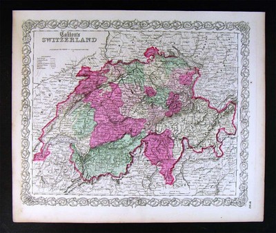
$12.45 Shipping Location: Cambridge, United States JH Colton & Co. New York. - No. 172 Williams St., New York 1855 Map of Switzerland Sheet. Hand-colored. Approximate size 17” x 13 3/4”. Has a couple small ... morefoxing age spots but very nice map. Shipped with USPS Priority Mail probably rolled.
Buy It Now
$4.99 Shipping Location: Fairview, United States Colton's General Atlas, published in New York by the Colton & Co., 1874. A facsimile copy of the title page will also be included for authenticity. Condition: ... moreThe map is in Very Good condition with overall light tonal aging and original hand coloring as issued.
Buy It Now
Free Shipping Location: Schertz, United States This is an Authentic / Original Antique Atlas Map. It is not *NEW* or in *NEW* condition, it was printed in the year indicated. We sell only Old Antique ... moreMaps, not prints, copies or posters. See Photo for best description, this is the actual map you will receive.
Buy It Now
$4.99 Shipping Location: Fairview, United States It is not mounted nor matted, being sold as a single sheet as seen in the main pic. Condition: Very Good, original handcoloring as issued with text on ... morereverse. An Original Antique Map: Not a Reproduction!
Buy It Now
Free Shipping Location: Schertz, United States This is an Authentic / Original Antique Atlas Map. It is not *NEW* or in *NEW* condition, it was printed in the year indicated. We sell only Old Antique ... moreMaps, not prints, copies or posters. See Photo for best description, this is the actual map you will receive.
Buy It Now
$11.80 Shipping Location: Eagle, United States Presented is an authentic, old Colton's map from 1855. Original hand color.
Buy It Now
$10.06 Shipping Condition: Unspecified Location: LONDON, United Kingdom Large, decorative hand coloured 19th century atlas map, 1861. DATE PRINTED: 1861. 'Johnson's Kentucky and Tennessee'. Caption below picture:'Johnson's ... moreKentucky and Tennessee '. CONDITION: Good; suitable for framing.
Buy It Now
$6.80 Shipping Location: Eagle, United States Presented is an authentic, old map taken from a dis-bound Colton's Atlas from 1855. Original hand color. This is a perfect opportunity to add to your ... moregrowing collection.
Buy It Now
Free Shipping Location: Schertz, United States This is an Authentic / Original Antique Atlas Map. It is not *NEW* or in *NEW* condition, it was printed in the year indicated. We sell only Old Antique ... moreMaps, not prints, copies or posters. See Photo for best description, this is the actual map you will receive.
Buy It Now
$6.00 Shipping Location: Piqua, United States This is for a nice, hand painted antique map. - does not effect the graphical area of the atlas. Map is in good condition, and does show typical page ... morediscoloration from age. I tried to capture them in the photo if so.
Buy It Now
Free Shipping Location: Schertz, United States This is an Authentic / Original Antique Atlas Map. It is not *NEW* or in *NEW* condition, it was printed in the year indicated. We sell only Old Antique ... moreMaps, not prints, copies or posters. See Photo for best description, this is the actual map you will receive.
Buy It Now
$5.00 Shipping Location: Jefferson City, United States YEAR: 1863. TITLE : Johnson's New Illustrated Family Atlas. SUBJECT: States of Iowa & Nebraska. Atlas cover and title page are not included and pictured ... morefor date and authenticity purpose only. PUBLISHER: Johnson & Ward.
Buy It Now
Free Shipping Location: Schertz, United States This is an Authentic / Original Antique Atlas Map. It is not *NEW* or in *NEW* condition, it was printed in the year indicated. We sell only Old Antique ... moreMaps, not prints, copies or posters. See Photo for best description, this is the actual map you will receive.
Buy It Now
Free Shipping Location: Eugene, United States This is the original antique hand colored 1855 map of AFRICA NORTH EASTERN SHEET published by JOSEPH HUTCHINS COLTON in his original 1855 ATLAS OF THE ... moreWORLD. This map includes ABYSSINIA, NUBIA and EGYPT, as well as TRIPOLI and SOMALIA.
Buy It Now
$10.06 Shipping Condition: Unspecified Location: LONDON, United Kingdom Large, decorative hand coloured 19th century atlas map, 1861. DATE PRINTED: 1861.
Buy It Now
Free Shipping Location: Schertz, United States This is an Authentic / Original Antique Atlas Map. It is not *NEW* or in *NEW* condition, it was printed in the year indicated. We sell only Old Antique ... moreMaps, not prints, copies or posters. See Photo for best description, this is the actual map you will receive.
Buy It Now
$11.80 Shipping Location: Eagle, United States Presented is an authentic, old Colton's map from 1855. Original hand color.
Buy It Now
$11.80 Shipping Location: Eagle, United States Presented is an authentic, old Colton's map from 1855. Original hand color.
Buy It Now
$11.80 Shipping Location: Eagle, United States Presented is an authentic, old Colton's map from 1855. Original hand color.
Buy It Now
$8.50 Shipping Location: Prospect, United States Approximate map size: 27" x 17". Condition: light soiling, toning, edge wear and tears.
Buy It Now
$10.00 Shipping Location: Montrose, United States Publisher:J.H. Colton & Co. Original Antique Map of the Western Hemisphere. Date: 1856 first edition (on the map it says "Entered as an Act of Congress ... morein the year 1855" but the atlas was published in 1856) Heavy paper-Hand Colored.
Buy It Now
Free Shipping Location: Schertz, United States This is an Authentic / Original Antique Atlas Map. It is not *NEW* or in *NEW* condition, it was printed in the year indicated. We sell only Old Antique ... moreMaps, not prints, copies or posters. See Photo for best description, this is the actual map you will receive.
Buy It Now
$8.70 Shipping Location: Piqua, United States GREECE and the IONIAN REPUBLIC +. This is for a nice, hand painted antique map. - does not effect the graphical area of the atlas. This map is in good ... morecondition, and does show typical page discoloration from age.
Buy It Now
$11.80 Shipping Location: Eagle, United States Presented is an authentic, old Colton's map from 1855. Original hand color.
Buy It Now
Free Shipping Location: Schertz, United States This is an Authentic / Original Antique Atlas Map. It is not *NEW* or in *NEW* condition, it was printed in the year indicated. We sell only Old Antique ... moreMaps, not prints, copies or posters. See Photo for best description, this is the actual map you will receive.
Buy It Now
$25.00 Shipping Location: Belvedere Tiburon, United States For opportunity, for freedom, and even for leisure. It was printed as a color lithograph and was originally issued as a folding map in a brown cloth folder ... morewith an impressed title in gilt lettering.
Buy It Now
$7.00 Shipping Location: North Wales, United States 1856 COLTON'S ATLAS OF THE WORLD-MAP OF LAKES & ISLANDS IN THE EAST & WEST ORIGINAL ANTIQUE ATLAS ENGRAVING PLEASE SEE PHOTOS AS PART OF THE DESCRIPTION ... moreCONDITION: ENGRAVING IS IN GOOD CONDITION. SIZE: APPROXIMATELY 10" X 13" SHIPPING: U.S. FIRST CLASS RATE - $7.00 - ANY ITEM WHICH SELLS FOR OVER $100 WILL REQUIRE INSURANCE WE COMBINE SHIPPING FOR MULTIPLE WINS. THANK YOU FOR YOUR INTEREST IN OUR AUCTIONS!.
Buy It Now
$10.06 Shipping Condition: Unspecified Location: LONDON, United Kingdom 'Colton's Kansas and Nebraska'. Title of map (not printed on the page):'Colton's Kansas and Nebraska'. Antique engraved hand coloured atlas map, 1863. ... moreDATE PRINTED: 1863. CONDITION: Good; suitable for framing.
Buy It Now
$11.80 Shipping Location: Eagle, United States Presented is an authentic, old Colton's map from 1855. Original hand color.
Buy It Now
$11.80 Shipping Location: Eagle, United States Presented is an authentic, old Colton's map from 1855. Original hand color.
Buy It Now
$10.00 Shipping Location: Montrose, United States Publisher: J.H. Colton & Co. Date: 1856 First Edition (on the map it says "Entered as an Act of Congress in the year 1855" but the atlas was published ... morein 1856). Original Antique Map. Size: 13" x 15 1/2" (including margins 16" x 18 ") 33 x 39 cm (including margins 41 x 47cm).
Buy It Now
$11.80 Shipping Location: Eagle, United States Presented is an authentic, old Colton's map from 1855. Original hand color.
Buy It Now
Free Shipping Location: Schertz, United States This is an Authentic / Original Antique Atlas Map. It is not *NEW* or in *NEW* condition, it was printed in the year indicated. We sell only Old Antique ... moreMaps, not prints, copies or posters. See Photo for best description, this is the actual map you will receive.
Buy It Now
$2.75 Shipping Location: San Diego, United States SEE ALL MY EBAY ITEMS: EBAY ADVANCE SEARCH. SELLER, mapseller01 Terms: Domestic and Overseas shipping as per prices listed on bid details. Please note: ... moreNo refunds on overseas items sent without tracking. Shipping the following day after receipt of payment. Any questions. Please email or you can call: The Map Seller 1-858-571-2031. We only sell maps. Prints and books relating to cartography. We answer all questions in a timely manner. No reproductions unless clearly stated. Additional cartographic materials available at PS Maps.

Buy It Now
$15.00 Shipping Location: Brooklyn, United States 1861 Johnson's Map of New Brunswick. Nova Scotia& Newfoundland(Canada) WE SELL ONLY ORIGINAL ANTIQUE MAPS- NOT REPRODUCTIONS Title: Johnson’s ... moreNew Brunswick. Nova Scotia, Newfoundland and Prince Edward Id. Description: A beautiful 1861 example of Johnson's map of Canada's Maritime Provinces. Including New Brunswick, Nova Scotia, Newfoundland, and Prince Edward Island. Like most of Johnson's maps, this map was derived from an earlier map by J. H. Colton issued in 1855. The map covers all of New Brunswick, Nova Scotia, Newfoundland and Prince Edward, along with a portion of adjacent Quebec. Canadian provinces and territories were under British and French control from the 16th century, until France gave up its claims in the Treaty of Paris in 1763. Canada would remain a collection of British colonies until its confederation in 1867, when the British colonies of New Brunswick and Nova Scotia would become Canadian provinces along with Ontario and Quebec. Although known as the'Birthplace of Confederation' Prince Edward Island would only join the confederation in 1873. This map also identifies various forts, rivers, mountain passes, fords, and an assortment of additional topographical details. Map is hand colored in pink, green, yellow and blue pastels to define state and territorial boundaries. Features the strapwork style border common to Johnson’s atlas work from 1860 to 1863. Published by A. J. Johnson and Browning as plate number 19 in the 1861 edition of Johnson’s New Illustrated Family Atlas. This is the last edition of the Johnson Atlas to bear the'Johnson and Browning' imprint. Subsequent editions reflect Ward's 1862 acquisition Ross C. Browning's shares in the firm. Size: Printed area measures 13 inches high by 16.5 inches wide. Condition: Very good. Some marginal soiling. Shipping: Due to recent increases in United States Postal Service rates we have been forced to increase our shipping rates. Shipping rates are not negotiable. Items are shipped within three business
Buy It Now
$15.45 Shipping Location: Bolivia, United States Original Hand-Colored Map of Maine Philadelphia, PA: O.W. Gray & Son, 1882. One sheet, printed with 1 map, from the 1882 O.W. Gray National Atlas, New ... moreYork Edition: Maine. 14" x 17 1/4" overall size; a little even toning to the paper, bottom margin with a few little edge-nicks; in very good condition.
Buy It Now
$11.80 Shipping Location: Eagle, United States Presented is an authentic, old hand-colored map taken from a dis-bound Colton's atlas published in 1855.
Buy It Now
Free Shipping Location: Columbia, United States A beautiful 1855 first edition Colton map. Title : Asia. Size: ~14in x 17in (35cm x 43cm).
Buy It Now
$6.95 Shipping Location: Dover, United States Nice 19th century lithographed map with original hand color. Based on the Colton 1855 map. Issued 1876-9, Philadelphia by M.R. Brown for O.W. Gray.
|
|
|
In
|
ORIGINAL ANTIQUE1866 Colton MAP OF OHIO * Hand Colored RARE
Beautiful detail and character. And measures approx 14.5"X 17" Please email any questions Thanks!
|
|
|
Geophysical Map of the United States by Colton 1858 with rain chart
Title: United States of America Maker: J.H. Colton. Date: 1858. Description: Steel-engraved geophysical map of the United States showing isothermal lines and mountain chains. Original hand coloring shows the Atlantic and Pacific Slopes. The basin of the Mississippi River, etc. Measures 11.75 x 14.5 inches. Map features a rain chart insert. Legend, and broken flower border. Ships within the U.S. only. California residents will be charged sales tax. Feel free to send us any questions or offers for this piece.
|
|
|
OLD Original Antique 1866 Colton Map of Iowa from Atlas hand tinted
Beautiful and detailed with old charm and character. Original from Colton's 1866 General Atlas, measures approx 14.5" X 17" Please email any questions Thanks.
|
|
|
Rare1866 antique original hand tinted Colton's Map of Delaware and Maryland
Beautiful detail and character. Item has some wear due to it age, and measures approx 14.5 X17" Please email any questions Thanks!
|
|
|
1855 Colton's Antique Atlas Color Map Of Australia BEAUTIFUL
Up for bids is this genuine 1855 Coltons atlas map of Australia. In very good condition with edges in great shape. Originally matted and framed. Has good color and paper is in great condition for it age. This map was published by G.W. and C.B. Colton& Co. No. 172 William St. New York. The map is No. 117. Please see pictures and feel free to email with any questions. This map is professionally framed. The frame measures 21" x 25" If you would like to have the map sent unframed let us know. It will still be shipped flat(not rolled up) on matting. The shipping cost would be the lesser of the two quoted in the listing. Payment is required within 3 days of end of auction. Posted with
|
|
|
1855 Colton Map of CUBA, JAMAICA, PUERTO RICO * Original Antique! 53
1855 Colton Map of CUBA. JAMAICA, PUERTO RICO* Original Antique! 53 This beautiful map is from the famous Colton Atlas with original hand coloring. Colton was one of the premier American map publishers of the era from 1855 to 1880. They are renown for their pre-Civil War era maps. This is an original antique. NOT a reproduction and guaranteed to be over 150 years old. Size: Sheet size of map is 18.5" x 15" or 47cm x 38cm. Please click on my"ME" page to learn more about us. Looking for additional quality items? Check out our other auctions for more that we have listed on eBay! RcmdId ViewItemDescV4,RlogId p4%60bo7%60jtb9%3Fvo%7B%3Dd70f%2Bf%60%60%3E-144f4109a4e-0x117-
|
|
|
1855 Colton Map of WEST INDIES * Original Antique! 52
1855 Colton Map of WEST INDIES* Original Antique! 52 This beautiful map is from the famous Colton Atlas with original hand coloring. Colton was one of the premier American map publishers of the era from 1855 to 1880. They are renown for their pre-Civil War era maps. This is an original antique. NOT a reproduction and guaranteed to be over 150 years old. Size: Sheet size of map is 18.5" x 15" or 47cm x 38cm. Please click on my"ME" page to learn more about us. Looking for additional quality items? Check out our other auctions for more that we have listed on eBay!
|
|
|
1855 Colton Map of GUATEMALA HONDURAS COSTA RICA * Original Antique! 51
1855 Colton Map of GUATEMALA HONDURAS COSTA RICA* Original Antique! 51 This beautiful map is from the famous Colton Atlas with original hand coloring. Colton was one of the premier American map publishers of the era from 1855 to 1880. They are renown for their pre-Civil War era maps. This is an original antique. NOT a reproduction and guaranteed to be over 150 years old. Size: Sheet size of map is 18.5" x 15" or 47cm x 38cm. Please click on my"ME" page to learn more about us. Looking for additional quality items? Check out our other auctions for more that we have listed on eBay!
|
|
|
1855 Colton Map of MINNESOTA TERRITORY * Original Antique! 45
1855 Colton Map of MINNESOTA TERRITORY* Original Antique! 45 This beautiful map is from the famous Colton Atlas with original hand coloring. Colton was one of the premier American map publishers of the era from 1855 to 1880. They are renown for their pre-Civil War era maps. This is an original antique. NOT a reproduction and guaranteed to be over 150 years old. Size: Sheet size of map is 18.5" x 15" or 47cm x 38cm. Please click on my"ME" page to learn more about us. Looking for additional quality items? Check out our other auctions for more that we have listed on eBay!
|
|
|
WONDERFUL RARE 1850 MAP OF THE UNITED STATES PUBLISHED BY J. COLTON, NEW YORK
WONDERFUL RARE PRE CIVIL WAR- 1850 MAP OF THE UNITED STATES PUBLISHED BY J. COLTON. NEW YORK/ MAP IS PRINTED ON HEAVY PAPER WITH HEAVY CLOTH BACKING/ SIZE 34" X 44 1/2" EXC CONDITION-
|
|
|
1855 Colton Map of PERU, BOLIVIA * Original Antique! 56
1855 Colton Map of PERU. BOLIVIA* Original Antique! 56 This beautiful map is from the famous Colton Atlas with original hand coloring. Colton was one of the premier American map publishers of the era from 1855 to 1880. They are renown for their pre-Civil War era maps. This is an original antique. NOT a reproduction and guaranteed to be over 150 years old. Size: Sheet size of map is 18.5" x 15" or 47cm x 38cm. Please click on my"ME" page to learn more about us. Looking for additional quality items? Check out our other auctions for more that we have listed on eBay!
|
|
|
1855 Colton Map of ECUADOR, VENEZUELA, COLOMBIA * Original Antique! 55
1855 Colton Map of ECUADOR. VENEZUELA, COLOMBIA* Original Antique! 55 This beautiful map is from the famous Colton Atlas with original hand coloring. Colton was one of the premier American map publishers of the era from 1855 to 1880. They are renown for their pre-Civil War era maps. This is an original antique. NOT a reproduction and guaranteed to be over 150 years old. Size: Sheet size of map is 18.5" x 15" or 47cm x 38cm. Please click on my"ME" page to learn more about us. Looking for additional quality items? Check out our other auctions for more that we have listed on eBay!
|
|
|
1855 Colton Map of SOUTH AMERICA * Original Antique! 54
1855 Colton Map of SOUTH AMERICA* Original Antique! 54 This beautiful map is from the famous Colton Atlas with original hand coloring. Colton was one of the premier American map publishers of the era from 1855 to 1880. They are renown for their pre-Civil War era maps. This is an original antique. NOT a reproduction and guaranteed to be over 150 years old. Size: Sheet size of map is 18.5" x 15" or 47cm x 38cm. Please click on my"ME" page to learn more about us. Looking for additional quality items? Check out our other auctions for more that we have listed on eBay!
|
|
|
1855 Colton Map of PATAGONIA, FALKLAND ISLANDS * Original Antique! 59
1855 Colton Map of PATAGONIA. FALKLAND ISLANDS* Original Antique! 59 This beautiful map is from the famous Colton Atlas which was one of the premier American map publishers of the era from 1855 to 1880. They are renown for their pre-Civil War era maps. This is an original antique. NOT a reproduction and guaranteed to be over 150 years old. Size: Sheet size of map is 18.5" x 15" or 47cm x 38cm. Please click on my"ME" page to learn more about us. Looking for additional quality items? Check out our other auctions for more that we have listed on eBay! 0fe.RcmdId ViewItemDescV4,RlogId p4%60bo7%60jtb9%3Fuk%601d70f%2B%3E0fe-144f5662e7a-0x10b-
|
|
|
1855 Colton Map of ARGENTINA, CHILE, URUGUAY, PARAGUAY * Original Antique! 58
1855 Colton Map of ARGENTINA. CHILE, URUGUAY, PARAGUAY* Original Antique! 58 This beautiful map is from the famous Colton Atlas with original hand coloring. Colton was one of the premier American map publishers of the era from 1855 to 1880. They are renown for their pre-Civil War era maps. This is an original antique. NOT a reproduction and guaranteed to be over 150 years old. Size: Sheet size of map is 18.5" x 15" or 47cm x 38cm. Please click on my"ME" page to learn more about us. Looking for additional quality items? Check out our other auctions for more that we have listed on eBay!
|
|
|
1855 Colton Map of BRAZIL, GUAYANA * Original Antique! 57
1855 Colton Map of BRAZIL. GUAYANA* Original Antique! 57 This beautiful map is from the famous Colton Atlas with original hand coloring. Colton was one of the premier American map publishers of the era from 1855 to 1880. They are renown for their pre-Civil War era maps. This is an original antique. NOT a reproduction and guaranteed to be over 150 years old. Size: Sheet size of map is 18.5" x 15" or 47cm x 38cm. Please click on my"ME" page to learn more about us. Looking for additional quality items? Check out our other auctions for more that we have listed on eBay!
|
|
|
1855 Colton Map of NEBRASKA, KANZAS TERRITORY * Original Antique! 46
1855 Colton Map of NEBRASKA. KANZAS TERRITORY* Original Antique! 46 This beautiful map is from the famous Colton Atlas with original hand coloring. Colton was one of the premier American map publishers of the era from 1855 to 1880. They are renown for their pre-Civil War era maps. This is an original antique. NOT a reproduction and guaranteed to be over 150 years old. Size: Sheet size of map is 18.5" x 15" or 47cm x 38cm. Please click on my"ME" page to learn more about us. Looking for additional quality items? Check out our other auctions for more that we have listed on eBay!
|
|
|
1855 Colton Map of IOWA * Original Antique! 43
1855 Colton Map of IOWA* Original Antique! 43 This beautiful map is from the famous Colton Atlas with original hand coloring. Colton was one of the premier American map publishers of the era from 1855 to 1880. They are renown for their pre-Civil War era maps. This is an original antique. NOT a reproduction and guaranteed to be over 150 years old. Size: Sheet size of map is 18.5" x 15" or 47cm x 38cm. Please click on my"ME" page to learn more about us. Looking for additional quality items? Check out our other auctions for more that we have listed on eBay!
|
|
|
1855 Colton Map of MISSOURI * Original Antique! 42
1855 Colton Map of MISSOURI* Original Antique! 42 This beautiful map is from the famous Colton Atlas with original hand coloring. Colton was one of the premier American map publishers of the era from 1855 to 1880. They are renown for their pre-Civil War era maps. This is an original antique. NOT a reproduction and guaranteed to be over 150 years old. Size: Sheet size of map is 18.5" x 15" or 47cm x 38cm. Please click on my"ME" page to learn more about us. Looking for additional quality items? Check out our other auctions for more that we have listed on eBay!
|
|
|
1855 Colton Map of ARKANSAS * Original Antique! 33
1855 Colton Map of ARKANSAS* Original Antique! 33 This beautiful map is from the famous Colton Atlas with original hand coloring. Colton was one of the premier American map publishers of the era from 1855 to 1880. They are renown for their pre-Civil War era maps. This is an original antique. NOT a reproduction and guaranteed to be over 150 years old. Size: Sheet size of map is 18.5" x 15" or 47cm x 38cm. Please click on my"ME" page to learn more about us. Looking for additional quality items? Check out our other auctions for more that we have listed on eBay!
|
|
|
1855 Colton Map of MEXICO, TEXAS, NEW MEXICO * Original Antique! 50
1855 Colton Map of MEXICO. TEXAS, NEW MEXICO* Original Antique! 50 This beautiful map is from the famous Colton Atlas with original hand coloring. Colton was one of the premier American map publishers of the era from 1855 to 1880. They are renown for their pre-Civil War era maps. This is an original antique. NOT a reproduction and guaranteed to be over 150 years old. Size: Sheet size of map is 18.5" x 15" or 47cm x 38cm. Please click on my"ME" page to learn more about us. Looking for additional quality items? Check out our other auctions for more that we have listed on eBay!
|
|
|
1855 Colton Map of CALIFORNIA * Original Antique! 48
1855 Colton Map of CALIFORNIA* Original Antique! 48 This beautiful map is from the famous Colton Atlas with original hand coloring. Colton was one of the premier American map publishers of the era from 1855 to 1880. They are renown for their pre-Civil War era maps. This is an original antique. NOT a reproduction and guaranteed to be over 150 years old. Size: Sheet size of map is 18.5" x 15" or 47cm x 38cm. Please click on my"ME" page to learn more about us. Looking for additional quality items? Check out our other auctions for more that we have listed on eBay! 1?RcmdId ViewItemDescV4,RlogId p4%60bo7%60jtb9%3Feog4d72f%2B%3E%3B1%3F-144f5bf6c48-0x120-
|
|
|
1855 Colton Map of UTAH, NEW MEXICO TERRITORY * Original Antique! 47
1855 Colton Map of UTAH. NEW MEXICO TERRITORY* Original Antique! 47 This beautiful map is from the famous Colton Atlas with original hand coloring. Colton was one of the premier American map publishers of the era from 1855 to 1880. They are renown for their pre-Civil War era maps. This is an original antique. NOT a reproduction and guaranteed to be over 150 years old. Size: Sheet size of map is 18.5" x 15" or 47cm x 38cm. Please click on my"ME" page to learn more about us. Looking for additional quality items? Check out our other auctions for more that we have listed on eBay!
|
|
|
1855 Colton Map of KENTUCKY, TENNESSEE * Original Antique! 34
1855 Colton Map of KENTUCKY. TENNESSEE* Original Antique! 34 This beautiful map is from the famous Colton Atlas with original hand coloring. Colton was one of the premier American map publishers of the era from 1855 to 1880. They are renown for their pre-Civil War era maps. This is an original antique. NOT a reproduction and guaranteed to be over 150 years old. Size: Sheet size of map is 18.5" x 15" or 47cm x 38cm. Please click on my"ME" page to learn more about us. Looking for additional quality items? Check out our other auctions for more that we have listed on eBay! 3c0.RcmdId ViewItemDescV4,RlogId p4%60bo7%60jtb9%3Feog4d71f%2B%3E3c0-144f6092ef7-0x112-
|
|
|
RUSSIA MAP,Original J H Colton Hand Colored RARE UKRAINE,POLAND,MOSCOW,BLACK SE
No 21 framed J.H.COLTON AND CO MAP HOMANN.UCRANIAE,UKRAINE,UCRANIA, POLAND.RUSSIA,KIEV,MOSCOW,BLACK SEA,KYIV Not sure of age Size of frame: 59cm x 52cm x 2cm BY J.H,COLTON AND CO 172 WILLIAM STREET NEW YORK ONE FOR THE MAP COLLECTOR AND A MUST TO HAVE ON YOUR WALL for more great items! CONTACT MUST BE MADE WITHIN 3 DAYS OF AUCTION FINISHING TO INFORM ME HOW YOU INTEND TO PAY AND. IF PAYMENT IS TO BE MADE BY CHEQUE THEN ITEM/S WILL BE SENT OUT ONCE FUNDS HAVE CLEARED WHICH IS USUALLY 5-7 WORKING DAYS. TERMS: I aim to give good clear descriptions of listed items. If you have any questions about this item listed please contact me and i will reply as soon as possible. POSTAGE AND POSTING: I aim to post within 48 hours of cleared payment. All parcels are sent recorded signed for bigger items are sent Door 2 Door via courier service all tracked. ... moreTracking number sent to you once item has been booked with the courier Monday to Friday, not weekends or UK bank holidays. Collections from us normally take place on Tuesdays and Thursdays. REFUNDS: I offer a' no reason' refund policy if notified within 7 days of delivery which is 2 working days for the UK and 5 working days overseas. Refunds covers the original payment. I only refund once the item has been returned in the condition it was sent out. FEEDBACK: Please contact me before leaving feedback. If for some reason you are not happy with your purchase. So that any problem can be resolved. ALL POSTAGE AND SHIPPING COSTS ARE NOT JUST THE COST OF A STAMP THIS ALSO INCLUDES THE PACKAGING AND ENVELOPES THAT ARE USED. Other Items. Txzj pxzj3952 txzj89
|
|
|
1855 Colton Map of MICHIGAN * Original Antique! 38
1855 Colton Map of MICHIGAN* Original Antique! 38 This beautiful map is from the famous Colton Atlas with original hand coloring. Colton was one of the premier American map publishers of the era from 1855 to 1880. They are renown for their pre-Civil War era maps. This is an original antique. NOT a reproduction and guaranteed to be over 150 years old. Size: Sheet size of map is 18.5" x 15" or 47cm x 38cm. Please click on my"ME" page to learn more about us. Looking for additional quality items? Check out our other auctions for more that we have listed on eBay!
|
|
|
1855 Colton Map of PITTSBURGH, CINCINNATI CITY PLAN * Original Antique! 35
1855 Colton Map of PITTSBURGH. CINCINNATI CITY PLAN* Original Antique! 35 This beautiful map is from the famous Colton Atlas with original hand coloring. Colton was one of the premier American map publishers of the era from 1855 to 1880. They are renown for their pre-Civil War era maps. This is an original antique. NOT a reproduction and guaranteed to be over 150 years old. Size: Sheet size of map is 18.5" x 15" or 47cm x 38cm. Please click on my"ME" page to learn more about us. Looking for additional quality items? Check out our other auctions for more that we have listed on eBay!
|
|
|
1855 Colton Map of INDIANA * Original Antique! 37
1855 Colton Map of INDIANA* Original Antique! 37 This beautiful map is from the famous Colton Atlas with original hand coloring. Colton was one of the premier American map publishers of the era from 1855 to 1880. They are renown for their pre-Civil War era maps. This is an original antique. NOT a reproduction and guaranteed to be over 150 years old. Size: Sheet size of map is 18.5" x 15" or 47cm x 38cm. Please click on my"ME" page to learn more about us. Looking for additional quality items? Check out our other auctions for more that we have listed on eBay!
|
|
|
1855 Colton Map of MICHIGAN UP, LAKE SUPERIOR * Original Antique! 39
1855 Colton Map of MICHIGAN UP. LAKE SUPERIOR* Original Antique! 39 This beautiful map is from the famous Colton Atlas with original hand coloring. Colton was one of the premier American map publishers of the era from 1855 to 1880. They are renown for their pre-Civil War era maps. This is an original antique. NOT a reproduction and guaranteed to be over 150 years old. Size: Sheet size of map is 18.5" x 15" or 47cm x 38cm. Please click on my"ME" page to learn more about us. Looking for additional quality items? Check out our other auctions for more that we have listed on eBay!
|
|
|
1855 Colton Map of OREGON, WASHINGTON * Original Antique! 49
1855 Colton Map of OREGON. WASHINGTON* Original Antique! 49 This beautiful map is from the famous Colton Atlas with original hand coloring. Colton was one of the premier American map publishers of the era from 1855 to 1880. They are renown for their pre-Civil War era maps. This is an original antique. NOT a reproduction and guaranteed to be over 150 years old. Size: Sheet size of map is 18.5" x 15" or 47cm x 38cm. Please click on my"ME" page to learn more about us. Looking for additional quality items? Check out our other auctions for more that we have listed on eBay!
|
|
|
1855 Colton Map of WISCONSIN * Original Antique! 44
1855 Colton Map of WISCONSIN* Original Antique! 44 This beautiful map is from the famous Colton Atlas with original hand coloring. Colton was one of the premier American map publishers of the era from 1855 to 1880. They are renown for their pre-Civil War era maps. This is an original antique. NOT a reproduction and guaranteed to be over 150 years old. Size: Sheet size of map is 18.5" x 15" or 47cm x 38cm. Please click on my"ME" page to learn more about us. Looking for additional quality items? Check out our other auctions for more that we have listed on eBay!
|
|
|
1855 Colton Map of OHIO * Original Antique! 35
1855 Colton Map of OHIO* Original Antique! 35 This beautiful map is from the famous Colton Atlas with original hand coloring. Colton was one of the premier American map publishers of the era from 1855 to 1880. They are renown for their pre-Civil War era maps. This is an original antique. NOT a reproduction and guaranteed to be over 150 years old. Size: Sheet size of map is 18.5" x 15" or 47cm x 38cm. Please click on my"ME" page to learn more about us. Looking for additional quality items? Check out our other auctions for more that we have listed on eBay!
|
|
|
1855 Colton Map of ILLINOIS * Original Antique! 40
1855 Colton Map of ILLINOIS* Original Antique! 40 This beautiful map is from the famous Colton Atlas with original hand coloring. Colton was one of the premier American map publishers of the era from 1855 to 1880. They are renown for their pre-Civil War era maps. This is an original antique. NOT a reproduction and guaranteed to be over 150 years old. Size: Sheet size of map is 18.5" x 15" or 47cm x 38cm. Please click on my"ME" page to learn more about us. Looking for additional quality items? Check out our other auctions for more that we have listed on eBay! 336.RcmdId ViewItemDescV4,RlogId p4%60bo7%60jtb9%3Fvo%7B%3Dd70f%2B%3E336-145055649bd-0x110-
|
|
|
1855 Colton Map of CHICAGO, ST. LOUIS CITY PLAN * Original Antique! 41
1855 Colton Map of CHICAGO. ST. LOUIS CITY PLAN* Original Antique! 41 This beautiful map is from the famous Colton Atlas with original hand coloring. Colton was one of the premier American map publishers of the era from 1855 to 1880. They are renown for their pre-Civil War era maps. This is an original antique. NOT a reproduction and guaranteed to be over 150 years old. Size: Sheet size of map is 18.5" x 15" or 47cm x 38cm. Please click on my"ME" page to learn more about us. Looking for additional quality items? Check out our other auctions for more that we have listed on eBay! 2p5ddv.RcmdId ViewItemDescV4,RlogId p4%60bo7%60jtb9%3Fuk%601d72f%2B26rk%3E2p5ddv-1450556db90-0x137-
|
|
|
1855 Full Hand Color COLTON Map of PITTSBURGH & CINCINNATI- Street Level Detaill
1855 Pre Civil War Hand Colored Map of PITTSBURGH and CINCINNATI A J.H. Colton Work of Art A gorgeous diptych style hand colored J.H. Colton map entitled CITIES OF PITTSBURGH AND ALLEGHENY WITH PARTS OF ADJACENT BOROUGHS. PENNSYLVANIA and the second is entitled THE CITY OF CINCINNATI OHIO dated 1855. Just a few years before the outbreak of the Civil War. A fantastically detailed map showing both Pittsburgh and Allegheny City and Cincinnati. Ohio as they were in the middle of the 19th Century. The cities are shown at street level detail with many of the important civic buildings named and each of the City Wards or boroughs are shown. The railroads and canal systems are detailed. The color on this map is particularly nice. This map was printed as part of Colton's Atlas Of The World Illustrating Physical And Political Geography. By George ... moreW. Colton. Accompanied By Descriptions Geographical. Statistical, And Historical, By Richard Swainson Fisher, M.D. New York: J.H. Colton And Company No. 172 William. Corner Beekman Street. London: Trubner And Company, No. 12 Paternoster Row. 1856. and includes the notation"Entered according to Act of Congress in the year 1855 by J.H. Colton& Co. in the Clerk's Office of the District Court of the United States for the Southern District of New York" just above the decorative floral border. Nice size. Page is 14½" by 17½" with large margins, excellent for framing. Condition In excellent shape. This 159 year old map shows almost no wear. Printed on heavy paper. This is a must see/buy. Shipping. Packing and handling charges are a flat $5.00 in the United States, international will vary by the location. This item is unconditionally guaranteed to be original and as described. We do not sell reproductions or copies. Thank you for bidding. Westside Antiques Norman Riggs 3/30/2014 0fe.RcmdId ViewItemDescV4,RlogId p4%60bo7%60jtb9%3Fuk%601d70f%2B%3E0fe-14517f49b26-0x108-
|
|
|
1858 Colton Map of Russia and Eastern Europe
1858 Colton Map of Russia and Eastern Europe WE SELL ONLY ORIGINAL ANTIQUE MAPS- NOT REPRODUCTIONS Title: Eastern Europe. Description: A rare example of Colton's 1858 map of eastern europe. Centered over Russia. The map covers Norway, Sweden, Turkey and Greece, and parts of Germany, Prussia, Italy and Austria. This beautiful hand colored map is a copper plate engraving, featuring a delicate floral style border only used by Colton in this particular atlas. It offers fine detail throughout with elevation rendered by hachure. Divided and color coded according to country, shows major towns and cities, railroads as well as geological features such as lakes and rivers. Russia at this time was under the suzerainty of Tzar Alexander the II. Alexander is best known for his liberal reforms including the emancipation Reform of 1861, considered to ... morebe the most important event in 19th century Russian history, which liberated Russia's countless serfs. Although this particular map is not dated, it is issued as part of the1859 edition of Colton's Illustrated Cabinet Atlas and Descriptive Geography. Size: Printed area measures 13.5 inches high by 11 inches wide. Condition: Very good. Blank on verso. Stains on margins. Shipping: Due to recent increases in United States Postal Service rates we have been forced to increase our shipping rates. Shipping rates are not negotiable. Items are shipped within three business days of receiving payment. We are happy to consolidate shipping where possible. The following shipping options are available: 1. USPS Domestic Express Mail(35 USD) USA Only. 2. FedEx Ground or Home Delivery(15 USD) USA Only. 1- 10 days. If your address is a P.O.Box and cannot ship FedEx we will ship USPS Priority and. While we ship promptly, recent postal personnel cutbacks mean that delivery may take up to 1 month. 3. DHL International EXPRESS(40- 50 USD) 4. We can use your Federal Express Account. Insurance: All shipments are insured privately against loss and damage. All of our shipments require a signature
|
|
|
1858 Colton Map of Europe (Physical)
1858 Colton Map of Europe(Physical) WE SELL ONLY ORIGINAL ANTIQUE MAPS- NOT REPRODUCTIONS Title: Europe(physical) Description: A rare example of Colton's 1858 physical map of europe. The map depicts the physical geography of europe from Norway and Sweden to the Mediterranean Sea and from Portugal to Russia and also covers Iceland. Although major cities are labeled. Political distinctions are not. Color coded according to terrain, shows major cities, rivers, mountains, capes, oceans and ocean currents with mean temperatures marked. Chief products and minerals of each country are also marked. A land elevation profile of europe is shows at the bottom of the map. The top left and the bottom of the map, above the land elevation profile, contains small paragraphs with information about the markings on the map. This beautiful hand colored map ... moreis a copper plate engraving, featuring a delicate floral style border only used by Colton in this particular atlas. Dated and copyrighted to J. H. Colton, 1859, this map is by G. Woolworth Colton and the text is by Richard Swainson Fisher. Published from Colton's 172 William Street Office in New York City an issued as part of the1859 edition of Colton's Illustrated Cabinet Atlas and Descriptive Geography. Size: Printed area measures 13.5 inches high by 11 inches wide. Condition: Very good. Blank on verso. Minor stains on margins. Shipping: Due to recent increases in United States Postal Service rates we have been forced to increase our shipping rates. Shipping rates are not negotiable. Items are shipped within three business days of receiving payment. We are happy to consolidate shipping where possible. The following shipping options are available: 1. USPS Domestic Express Mail(35 USD) USA Only. 2. FedEx Ground or Home Delivery(15 USD) USA Only. 1- 10 days. If your address is a P.O.Box and cannot ship FedEx we will ship USPS Priority and. While we ship promptly, recent postal personnel cutbacks mean that delivery may take up to 1 month. 3. DHL International EXPRESS(40-
|
|
|
1866 Colton Map of Staten Island, New York City
1866 Colton Map of Staten Island. New York City WE SELL ONLY ORIGINAL ANTIQUE MAPS- NOT REPRODUCTIONS Title: Map of Staten Island Richmond County State of New York. Description: A scarce large format pocket map of New York City's Staten Island. This is one of the few detailed maps of Staten Island from the middle part of the 19th century. The map covers the entirety of Staten Island from Bayonne and Perth Amboy to Brooklyn and Gowanus Bay. The whole is color coded by political district and all major streets and even individual residences are noted with landowner names. Topography is rendered in hachure. This map is extremely rare with only one other inferior example of this edition known- this being held at the New York Public Library. A later updated and revised edition with the same title and covering roughly the same area was issued ... morearound 1886. Size: Printed area measures 27 inches high by 30.5 inches wide. Condition: Very good. Removed from original binder(included) and professionally backed with archival tissue. Minor discoloration where attached to original binder- see image. Else a beautiful bright example. Shipping: Due to recent increases in United States Postal Service rates we have been forced to increase our shipping rates. Shipping rates are not negotiable. Items are shipped within three business days of receiving payment. We are happy to consolidate shipping where possible. The following shipping options are available: 1. USPS Domestic Express Mail(35 USD) USA Only. 2. FedEx Ground or Home Delivery(15 USD) USA Only. 1- 10 days. If your address is a P.O.Box and cannot ship FedEx we will ship USPS Priority and. While we ship promptly, recent postal personnel cutbacks mean that delivery may take up to 1 month. 3. DHL International EXPRESS(40- 50 USD) 4. We can use your Federal Express Account. Insurance: All shipments are insured privately against loss and damage. All of our shipments require a signature. If you have any questions please feel free to email us through eBay or contact us by
|
|
|
1856 Colton Map or Plan of Washington D.C.
1856 Colton Map or Plan of Washington D.C. WE SELL ONLY ORIGINAL ANTIQUE MAPS- NOT REPRODUCTIONS Title: Georgetown and the City of Washington The Capital of the United States of America. Description: A beautiful 1856 example of Colton's map of Washington D.C. and Georgetown. Like most of Colton's state maps. This map was derived from an earlier wall map of North America produced by Colton and D. Griffing Johnson. Covers the city in incredible detain from Georgetown(Georgetown University, then college) in the upper left quadrant and Rosslyn to Alexander's Island in the south and east as far as Magazine Warf. The map is a lithographic engraving covering the nation's capital shortly before the outbreak of the American Civil War. Notes numerous important buildings including the Capitol, the Smithsonian Institution, the White House(not ... moreyet called the White House) the Washington Monument, the National Observatory, the Navel Yard, the Poor House, the Arsenal, Penitentiary and others. The city's famous grid and ray structure appear according to L'Enfant's brilliant plan. Georgetown appears as a separate entity in the upper left corner with Georgetown College noted just outside the city border. Also shown are proposed landfills and extensions to the east side of the city into the east branch of the Potomac River. The map also contains illustrated views of The Smithsonian Institute, Washington Monument and the Capitol Building. The second dome of the Capitol Building(the first was a smaller, green copper dome) is shown complete in the upper right hand quadrant of this map, though in fact it was only partially built when this map was issued. Surrounded by Colton's typical spiral motif border. Dated and copyrighted to J. H. Colton, 1855. Published from Colton's 172 William Street Office in New York City. Issued as page no. 24 in volume 1 of Colton's 1856 Atlas of the World. Size: Printed area measures 14 inches high by 17 inches wide. Condition: Very good. Minor spotting at places. Esp
|
|
|
1846 / 1878 Colton Map of New York City and Vicinity (33 Miles Around)
1846/ 1878 Colton Map of New York City and Vicinity(33 Miles Around) WE SELL ONLY ORIGINAL ANTIQUE MAPS- NOT REPRODUCTIONS Title: Map of The Country Thirty Three Miles Around The City of New York. Description: This is the extremely rare 1878 edition of one of the most beautiful pocket maps of New York made in the 19th century: Colton’s Thirty Three Miles Around the City of New York. Covers New York City and vicinity as far south as Ocean County. NY, as far east as Suffolk County, as far north as Rockland County, and as far west as Somerset County. Reveals the area in considerable detail with special attention to settlements, tolls, roads, and railroads. Documents innumerable areas of interest included the New Lots in Brooklyn and a very early Central Park. New York Bay and Harbor offers numerous depth soundings taken from the 1858 U.S. Coast ... moreSurvey of the region. Surrounded by a splendid decorative border with engraved views depicting'City Hall, New York' and'City Hall, Brooklyn. This map was drawn and engraved by J. M Atwood based upon J. H. Eddy’s 1811 map of the same name. Colton’s success with this attractive map was such that it was issued in various editions for over 50 years. Haskell notes eight different editions between 1846 and 1873 and Rumsey has a variant dated 1891. Dated 1878 under the explanations and scale, the copyright reads: Entered according to the Act of Congress in the Year of 1846 by J. H. Colton in the Clerk’s Office of the District Court of the Southern District of New York. Published by G. W. and C. B. Colton and Co. 172 William St. New York. Size: Printed area measures 25 inches high by 24 inches wide. Condition: Very good. Minor wear along some of the original fold lines. Backed with original linen. Overall age toning. Shipping: Due to recent increases in United States Postal Service rates we have been forced to increase our shipping rates. Shipping rates are not negotiable. Items are shipped within three business days of receiving payment. We are happy to consolidate shipp
|
|
|
1874 COLTON MAP OF TEXAS FORTS SAN ANTONIO 'ALAMO 1836' AUSTIN GALVESTON DALLAS
ORIGINAL. NOT A COPY NOR A REPRINT, HAND COLORED MAP OF TEXAS DATED 1874 BY COLTON; MANY FORTS SHOWN; BY SAN ANTONIO"ALAMO 1836" 9.75" X 12" MARGINAL TONING IN TWO CORNERS; ARCHIVAL MEND TO MARGIN TEAR ON BACK; O/W VERY GOOD CONDITION AND VERY DISPLAYABLE-SEE PHOTOS. CHECK OUT MY OTHER EARLY ADS, HISTORIC AND SPORT ITEMS.
|
|
|
Antique J.H. Colton 1853 Pocket Map of Virginia Vintage Folded Hand Colored
Antique J.H. Colton 1853 Pocket Map of Virginia Vintage Folded Hand Colored For more interesting items No reserve auction for a Antique J.H. Colton Pocket Map of Virginia dated 1853. Looks to be hand colored. Nice condition in my opinion. Some tears along some of the folds(see photos) Color real nice. Map still attached to book. Map folds and fits into book. Book measures 3 1/4" x 5" When map is unfolded it measures 14" x 17" Please view all photos before bidding. FREE SHIPPING within the United States. 415115.0330. I accept PayPal only. Winning bidder must contact me within 3 days of auction closing to inform me of payment proceedings and their shipping address. All auctions must be paid for within 7 days of auction closing. If payment is not received within 7 days of the auction close date. Items will be relisted and ... morea non-paying bidder alert filed. PLEASE READ REGARDING SHIPPING OPTIONS: On most items I offer both USPS and UPS as domestic shipping options. Select the Payment/Shipping tab above to see both choices. Ebay requires the seller to select a preference regarding shipping. That is the price that you initially see on auction page and the price you see on Ebay generated invoices. You have the option when paying to select either shipping option. It is my objective to ship item to you via the least expensive method. After receiving payment. I usually ship items on Tuesdays and Fridays. In most cases I ship via USPS Priority Mail, but on occasion I use UPS. Combined Shipping- If possible, I will combine shipping on items purchased within a 3 day period and paid for together. For calculated shipping, I total weights for all items for the best rate. For fixed price shipping, I use the most expensive shipping plus $3.00 for each additional item. Shipping damage- Shipping damage must be reported immediately to the shipper and myself. Advise shipper and contact me through Ebay and I will advise you on how to proceed. ATTENTION International Buyers- Import duties, taxes and charges are not inc
|
|
|
1849 Colton Case Map of the United States (Texas at Fullest) (First Edition) (Go
1849 Colton Case Map of the United States(Texas at Fullest) First Edition) Gold Rush) WE SELL ONLY ORIGINAL ANTIQUE MAPS- NOT REPRODUCTIONS Title: Map of the United States of America. The British Provinces, Mexico, the West Indies, and Central America: with part of New Granada and Venezuela. Description: An exceptionally beautiful map of considerable historic importance. This is J. H. Colton's first edition 1849 map of the United States on the cusp of the California Gold Rush. Colton depicts the borders of the United States as consolidated under the 1848 Treaty of Guadeloupe Hidalgo signed at the end of the Mexican American War. The United States stretches from coast to coast with the Mexican Cession of Upper California or New California noted. Texas is rendered at its fullest extent as a state with its 1845- 1849 borders, including the ... morestovepipe northern panhandle. Alternative Texas borders and claims within the new state are also noted. Nebraska too is illustrated at its fullest extent reaching northwards as far as the Canadian border. Cartography in California remains primitive but the Gold Region on the Sacramento River around the town of New Helvetia, the original name of John Sutter's settlement, are noted. Possibly this map's most interesting feature is its thorough presentation of Texas- a topic no doubt much on the minds of Colton's educated American clientele. The map not only illustrates the borders under which Texas joined the Union in 1845, but also various alternative and conflicting borders actively debated during the Mexican American War until their ultimate resolution in the Compromise of 1850. These include highlights in blue showing Mexican claims as far northeast as the Nunces River- a major catalyst of the Mexican American War. Those who argued for a border at the Nunces River also argued that the border should continue north along the Guadeloupe Mountains roughly to the Red River Valley. Still other borders recognize old Mexican distinctions relating to the governance of Sant
|
|
|
colton map 1855 northren america
colton map 1855 northren america
|
|
|
Antique Authentic J. H. Colton 1855 Framed Atlas Map of Florida
Offered is an original hand colored framed 1855 Altlas map of Florida by J. H. Colton. Map number in Atlas was 30 and is so numbered on bottom right. Actual image is 15 3/4" by 12 1/2" Frame is 19 1/2" by 17" Please see all pictures and the condition statement. I pack well so bid with confidence of safe arrival. Insurance included in shipping. Email for additional info. I attempt to picture and describe any conditions that might affect the value of the item. Please ask before you bid if you need more information. Florida residents must either provide exemption certificate or pay the 6.5% sales tax. Powered by The free listing tool. List your items fast and easy and manage your active items.
|
|
|
1868 Colton Florida Hand Colored Map 18x28 Vintage US State Great Graphics
VINTAGE 1868 COLTON MAP OF FLORIDA Approximately 18" by 28" This vintage map is a great souvenir. It is in very good overall condition with wear at the edges and fold lines. I have taken a picture of the item so you can make your own judgment of its condition and bid accordingly. The item will be folded and protectively shipped. Please feel free to ask me any questions you desire. Winning bidder will be contacted promptly after end of auction and payment is expected within 4 days. I accept Paypal as well as whatever other payment methods are still allowed by eBay policies at the time of purchase. Shipping and handling is $4.95 within the US. This includes delivery confirmation tracking. This item will not be shipped overseas.
|
|
|
1855 Colton Vermont Hand Colored Map 15x17 Vintage US State Great Graphics
VINTAGE 1855 COLTON MAP OF VERMONT Approximately 15" by 17" This vintage map is a great souvenir. It is in used overall condition with wear at the edges and fold lines. It has border tears as can be seen in the photos. I have taken a picture of the item so you can make your own judgment of its condition and bid accordingly. The item will be folded and protectively shipped. Please feel free to ask me any questions you desire. Winning bidder will be contacted promptly after end of auction and payment is expected within 4 days. I accept Paypal as well as whatever other payment methods are still allowed by eBay policies at the time of purchase. Shipping and handling is $4.95 within the US. This includes delivery confirmation tracking. This item will not be shipped overseas.
|
|
|
1850's Colton Indiana Hand Colored Map 14x17 Vintage US State Color Counties
VINTAGE 1850's COLTON MAP OF INDIANA Approximately 14" by 17" This vintage map is a great souvenir. It is in good overall condition with wear at the edges and fold lines. It has border tears as can be seen in the photos. I have taken a picture of the item so you can make your own judgment of its condition and bid accordingly. The item will be folded and protectively shipped. Please feel free to ask me any questions you desire. Winning bidder will be contacted promptly after end of auction and payment is expected within 4 days. I accept Paypal as well as whatever other payment methods are still allowed by eBay policies at the time of purchase. Shipping and handling is $4.95 within the US. This includes delivery confirmation tracking. This item will not be shipped overseas.
|
|
|
1855 Colton Michigan and Lake Superior Double Sided Hand Colored Map 15x17
VINTAGE 1855 COLTON DOUBLE SIDED MAP OF MICHIGAN AND LAKE SUPERIOR Approximately 15" by 17" This vintage map is a great souvenir. It is in good overall condition with wear at the edges and fold lines. It has border tears as can be seen in the photos. I have taken a picture of the item so you can make your own judgment of its condition and bid accordingly. The item will be folded and protectively shipped. Please feel free to ask me any questions you desire. Winning bidder will be contacted promptly after end of auction and payment is expected within 4 days. I accept Paypal as well as whatever other payment methods are still allowed by eBay policies at the time of purchase. Shipping and handling is $4.95 within the US. This includes delivery confirmation tracking. This item will not be shipped overseas.
|
|
|
1855 Colton Ohio Hand Colored Map 15x17 Cleveland Inset Vintage US State
VINTAGE 1855 COLTON MAP OF OHIO Approximately 15" by 17" Cleveland Inset and Ohio Facts shown This vintage map is a great souvenir. It is in used overall condition with wear at the edges and fold lines. It has border tears as can be seen in the photos. I have taken a picture of the item so you can make your own judgment of its condition and bid accordingly. The item will be folded and protectively shipped. Please feel free to ask me any questions you desire. Winning bidder will be contacted promptly after end of auction and payment is expected within 4 days. I accept Paypal as well as whatever other payment methods are still allowed by eBay policies at the time of purchase. Shipping and handling is $4.95 within the US. This includes delivery confirmation tracking. This item will not be shipped overseas. 3c0.RcmdId ViewItemDescV4,RlogId ... morep4%60bo7%60jtb9%3Feog4d71f%2B%3E3c0-14546b4d817-0x111-
|
|
|
1860's Colton Ontario Canada Hand Colored Map 18x28 Vintage Antique Collectible
VINTAGE 1860's COLTON MAP OF ONTARIO CANADA Approximately 18" by 28" This vintage map is a great souvenir. It is in very good overall condition with wear at the edges and fold lines. I have taken a picture of the item so you can make your own judgment of its condition and bid accordingly. The item will be folded and protectively shipped. Please feel free to ask me any questions you desire. Winning bidder will be contacted promptly after end of auction and payment is expected within 4 days. I accept Paypal as well as whatever other payment methods are still allowed by eBay policies at the time of purchase. Foreign bidders must use Paypal when making payment. Shipping and handling is $4.95 within the US and $11.95 for overseas shipping. This includes delivery confirmation tracking for US shipments.
|
|
|
Original antique hand tinted 1866 Colton map ATLAS poster of New Jersey
Beautiful detail and character. This old map is really unique, measures approx 14.5"x17" Please email any questions Thanks!
|
|
|
1855 Colton Central America Hand Colored Map 15x17 Panama Nicaragua Manzanilla
VINTAGE 1855 COLTON MAP OF CENTRAL AMERICA Includes inset maps of Panama. Nicaragua and Manzanilla Island Approximately 15" by 17" This vintage map is a great souvenir. It is in used overall condition with wear and tear at the edges and fold lines. I have taken a picture of the item so you can make your own judgment of its condition and bid accordingly. The item will be folded and protectively shipped. Please feel free to ask me any questions you desire. Winning bidder will be contacted promptly after end of auction and payment is expected within 4 days. I accept Paypal as well as whatever other payment methods are still allowed by eBay policies at the time of purchase. Foreign bidders must use Paypal when making payment. Shipping and handling is $4.95 within the US and $11.95 for overseas shipping. This includes delivery confirmation ... moretracking for US shipments.
|
|
|
1859 map: Colton's Cuba, Jamaica and Porto Rico
1859 Colton's Cuba. Jamaica and Porto Rico Map from 1859 edition atlas. 13 x 16 inches(40 x 33 cm) with decorative“scroll-work” border. VG+ overall condition with slight age toning; verso with descriptive text"The West Indies: British Isles" Porto Rico in an inset map. Colored by Provinces(Cuba) and Parishes(Jamaica) Includes a few of the Bahamas and the Florida Keys. Usual Colton quality with excellent color. Well-applied. Dated 1855 on map. But from the 1859 edition of the Colton Atlas. On heavier than usual paper Terms: Shipping via USPS 1st Class in USA. We gladly take Paypal. We mail all items within 1 business day of receipt of funds. Any questions. Please email or you can call: Pacific Shore Maps 1-858-571-2031. We only sell items relating to cartography. We answer all questions in a timely manner. No reproductions unless ... moreclearly stated.
|
|
|
OLD MAP, JOHNSON'S SWITZERLAND 1798, HANDCOLORED, publish. Colton.New York, 1856
Size 18x13'
|
|
|
CHINA, AMOY, CANTON, Colton Original Hand Coloured Antique Map 1866
CHINA. AMOY, CANTON, Colton Original Hand Coloured Antique Map 1866, CHINA. AMOY, CANTON, Colton Original Hand Coloured Antique Map 1866 COLTON'S CHINA Published by G.W& C.B.Colton& Co. New York 1866 for Colton's General Atlas An attractive and decorative map of China with original hand colouring. The map also features two inset maps of Amoy& Canton. Colton's trademark ornate scrollwork border makes the map a pleasing item for display. Please view further close up images. Fine. Unmarked condition. Unrelated text verso, unfolded. Measuring approx. 15.5" x 12.5" 400mm x 320mm) including borders. With good margins beyond. GENUINE ANTIQUE MAP GUARANTEED OVER 140 YEARS OLD FROM LINDISFARNE PRINTS Two items will be combined with a single shipping charge Free shipping worldwide if three items or more purchased FB414. ... moreCloseups, Shipping Process, Two items are always combined for shipping and three items or more are shipped free of charge. Worldwide"Please see item description for postage costs" Payment Options, All major Credit and Debit Cards accepted by phone PAYPAL. Personal cheque drawn on UK banks only. Postal Orders from UK post offices only. Bank transfer- please email for details. About Us, Lindisfarne Prints is a small family business specialising in genuine antique maps and prints at affordable prices.Established in 1995 and trading online since 2000. We pride ourselves on accurate descriptions, good communications, rapid service and fair prices. We are proud to maintain a 100% positive feedback rating which we hope reflects this.To avoid confusion, no item less than 100 years old is ever offered for sale. We do not deal in reproductions, facsimiles or modern copies of any kind. So please buy with confidence in the safe knowledge that authenticity is unfailingly assured. Return Policy, Customer satisfaction is paramount and any item not exactly as described will be accepted for return. Without hesitation. The buyer is responsible for secure return postage. Related Pro
|
|
|
NORTH AMERICA Atlas MAP 1860 J H COLTON
Map is 11"H by 13 3/4"W GOOD CONDITION. other then minor edge and corner slight yellowing THIS MAP IS A 2 PAGE MAP WITH THE ORIGINAL CREASE! PAYPAL payment for this item needs to made within 48 hours of receiving billing THANK for doing business with MAINELY PAPER ANTIQUES
|
|
|
AUSTRALIA & NEW ZEALAND Atlas MAP 1865 COLTON
Map is 9 1/2"H by 12"W GOOD CONDITION. other then minor edge and corner slight yellowing PAYPAL payment for this item needs to made within 48 hours of receiving billing THANK for doing business with MAINELY PAPER ANTIQUES
|
|
|
1864 Map of Missouri and Kansas by J.H. Colton
Original Map of Minnesota. Dimensions of leaf are 9.25x12" Nice clean impression. Centerfold as issued. Currently wrapped in mylar(hence any possible glare) Will be rolled carefully in kraft paper and shipped in sturdy tube. Please ask questions before bidding.
|
|
|
NEW SECTIONAL MAP OF THE STATE OF ILLINOIS. COLTON 1857. MEASURE 29 X42 INCHES
new sectional map of the state of illinois. Compiled from the united states surveys. Also exhibiting the internal improvements. Distances between towns, villages, post offices, the outlines of prairies, woodlands, marshes, and the lands donated to the state by the genl. govt. for the purpose of internal improvements. By J. M. Peck. John Messinger, and A. J. Mathewson. New York: Published by J. H. Colton& Co. 1857. Engraved by S. Stiles& Co. N. York. Hand colored engraved folded pocket map. The unfolded map measures 29-1/2 x 42-1/4 inches; folded. It measures 4-1/4 x 6-1/8 inches. When folded. The front and back“covers” have a pastedown of heavy marbled paper. This map depicts the entire state of Illinois and has inset maps of“The vicinity of Galena. The Lead Region and part of Wisconsin and Iowa” at upper left. And at bottom left, ... morethe“Vicinity of Alton& St. Lewis. Map is within a decorative border. And includes an extensive legend, distance scales, and a table of the populations of towns and villages. A long panel at left discusses Public Land and Land Districts. And precisely defines the relevant Principal Meridians and Baselines, the layout of townships, and the boundaries of land districts. Many of Colton’s maps were available in a variety of forms. Including mounted, rolled and pocket format, like this copy. This copy has been precisely cut into 49 rectangular sections which have been mounted on a canvas backing. 7 sections across and 7 down, with 1/8-inch separation between, so that the folds are to the canvas and not to the paper. This accounts. In part, for the excellent condition of this copy. Entered according to the Act of Congress in the Year of 1836 by J. H. Colton& Co. in the Clerk’s Office of the District Court of the United States for the Southern District of New York. IN REALLY NICE CONDITION Check out my other items! International bidders please note: We only charge you for actual postage. No handling or packing fees. We are always happy to combine items to keep shipping costs
|
|
|
Scarce Beautiful Antique 1855 Folding Township Map of WISCONSIN by J.H. COLTON
HELLO. I HAVE A LARGE COLLECTION OF MISCELLANEOUS COLLECTIBLES GOING UP FOR AUCTION THIS WEEK SO PLEASE CHECK OUT MY OTHER AUCTIONS! Up for auction is a awesome scarce vintage"Township Map Of The State Of Wisconsin" This rare beauty was made by J. H. Colton& Co. of 172 William Street of New York. New York. This is a beautiful colored travel map. When closed and in book form it roughly measures 6" x 4" x.5" thick. When completely opened, map roughly measures 29" x 24" This original map has counties separated by colors, and its quite beautiful. Map has statistical population numbers& progress of population tables. It really is a stunning, early map! It would look great displayed and in ones collection. If you are interested in these type items, please check out my other items. Item does show normal ... morewear from use and age. Please check pictures above and decide condition yourself. Buy many items as I will package items together and save you a ton of money on shipping! Item you will be receiving is pictured above along with picture of cert that you will get. Great for the collector or as a gift! Please check out my other auctions for great vintage items and sports cards! Of Course I Will Combine Shipping Whenever Possible! All Sales Are Final! INSURANCE: Always available on all my auctions if you feel need to insure! I will package to best of my ability but that does not always matter! DOMESTIC SHIPPING& HANDLING: I ship everything through USPS. Upto 3 ounces I can mail first class but if it is over three ounces I PREFER SHIPPING PRIORITY MAIL unless otherwise stated. I Get delivery confirmation and you get your items within three business days from date of payment! I WILL COMBINE SHIPPING ON MULTIPLE WINS whenever possible. If you win a few auctions I will probably have to send out in a couple of boxes. I will do whatever I can to lower your shipping charges. I will send out media-mail if it is legally allowed to be shipped that way. I will also ship parcel-post if that
|
|
|
Rare Hand Colored Original Colton's Pocket Map 1869: Sectional Map Of Nebraska
C I R Q L A R Original antique prints. Books, maps and atlases Name Of Map New Sectional Map Of Nebraska And Part Of Dakota. Author/Artist Published by G.W. C.B. Colton. New York. Date of Publication Dated on map 1869. Miscellany Very difficult to acquire original hand colored large separately published pocket map of Nebraska with an inset of the adjoining states(Colorado. Kansas, Missouri etc) Map Dimensions Unfolds to ca 28 1/2" X 37 3/4" Case measures 6 1/8" X 4" Condition In overall very good to excellent condition. The map is still very much attached to the original hard cover cloth-bound case. Printed on onion skin paper. There are three smaller browning areas at the folds on the right side of the map. The coloring is bright. Description We are proud to be able to offer a difficult to acquire a very rare separately ... morepublished pocket map of Nebraska and parts of the Dakota Territory. There is a larger inset at the upper left corner showing the adjacent states. This map shows the towns and cities as well as the transportation routes along these mid-Atlantic states. It is indeed a rare map in exceptional. Apology-free condition. Thank you for looking and please be sure and look at our other auctions for other fine original natural history plates as well as original maps. All guaranteed original. Thank you for looking. We do not use the eBay check-out system for invoicing so it is not necessary to email us at auction end. You will receive an email from Paypal letting you know the particular payment options available to you. We will also send you an email summarizing your winning bids along with one combined postal charge. We will email you this summary within 24 hours after the auction's end. Cirqlar is a SquareTrade seller in good standing and we will do everything we can make this a positive experience for you. We don't hold checks for clearance(we have yet to receive a bad check after over 25.000 transactions! Again, we will be happy to combine purchases to save on your shipping co
|
|
|
Large Original 1865 Map Quebec New Brunswick by Colton
RARE& INTERESTING BOOKS/ ENGRAVINGS/ MAPS/ PAINTINGS/ ANTIQUES L U I S P O R R E T T A F I N E A R T S 1 Large Original 1865 Map Quebec New Brunswick by Colton. Colton. G. W. and C. B. MAP-CANADA EAST OR LOWER CANADA AND NEW BRUNSWICK. LARGE MAP OF NEW BRUNSWICK AND MAINE) 1865, 29" x 17" Published by G. W. C. B. Colton, This wonderful map published in 1865 is in very good condition. Full borders as published, decorative borders, original block and line color, shows areas of East Coast Canada and Maine. One or two closed tears at margins. Measures 29" x 17" A beautiful mapping! PLEASE READ OUR SHIPMENT AND PAYMENT TERMS BEFORE BUYING OR BIDDING. PLEASE NOTE- WE ARE CANADIAN DEALERS. SHIPPING WILL TAKE LONGER TO ARRIVE IN THE US THAN WOULD A U.S. PACKAGE. For example. A heavy item sent via Expedited Mail may take up ... moreto ten WORKING days to arrive(14 days) which given our in store clearance may take two weeks or more to arrive. Please be aware of this when you buy, or when you bid. We always SUBSIDISE our shipping costs which are CLEARLY stated in our advertisements. Canada Post is far more expensive compared to USPS. So before you buy or bid, please be sure that you are aware of shipping costs. WHEN REGISTERING FEEDBACK PLEASE BE AWARE OF THESE ISSUES- MANY THANKS! We accept CREDIT CARDS at our own secure server(quick and easy! We also accept PAYPAL. To pay at our secure server please click: CREDIT CARD PAYMENT. Shipping within North America Expedited Flat Rate Shipping Service Payment should be made within three days of the end of the auction. We amalgamate shipping for greater economy- so feel free to buy until it hurts! We offer a full refund for items not as described. Any items lost in the mail will be covered by our refund guarantee AFTER a Post Office search. The refund will not include the mailing costs. CANADIAN CLIENTS- Please note: HST will be applied as appropriate to your Province. International Buyers– Please Note: Import duties. Taxes and charges are not included in the ite
|
|
|
SCARCE J.H. Colton 1865 map of Florida with unique Florida South & Keys insets!!
Full Title: J.H. Colton's Map of Florida. Southern Part of Florida, and the Florida Keys. Author: Colton. J.H. Issued: 1865; First edition. Publisher: New York: J.H. Colton Description: Nice ORIGINAL antique map. Printed in the 19th century(1865) on quality paper which retains its inherent structural flexibility and soundness. ORIGINAL/beautiful hand-coloring. Is in pink, green, yellow, and blue tones. A scarce map(printed only in 1865) representing the only Florida tri-inset(Florida. Southern Part of Florida, and the Florida Keys) map made by J.H. Colton. A very pleasing and rare map of Florida. Condition: This original print from 1865 is in very good condition with a crisp impression. Good coloring, and no defects within the image except for several small(non-distracting) areas of light discoloration; the uncut sheet of paper has some ... moretoning and discoloration to lower edge, which can be easily covered with matting if framed. The printed area is visually pleasing with fine detail and coloring– an attractive and interesting antique map(see photos) Sheet measures: 9 3/8" H x 11 7/8" W. Printed map area measures: 8" H x 11 7/8" W. Guaranteed Authentic!
|
|
|
1860 Map: Colton's Illlinois--orignal & fully colored
1860 map: Coltons Illinois Map from 1860 edition of Colton's atlas. 16 x 13 inches(40 x 33 cm) with decorative“scroll-work” border. VG+ overall condition with slight age toning; verso blank BW inset map of"Vicinity of Chicago. Shows rail lines. Common roads, Canals, and settlements down to the"village' levet. Colored by Countiesry Terms: Shipping via USPS 1st Class in USA. We gladly take Paypal. We mail all items within 1 business day of receipt of funds. Any questions. Please email or you can call: Pacific Shore Maps 1-858-571-2031. We only sell items relating to cartography. We answer all questions in a timely manner. No reproductions unless clearly stated. Posted with.RcmdId ViewItemDescV4,RlogId p4%60bo7%60jtb9%3Fvo%7B%3Dd70f%2Bf54%3E-145aa83ce1b-0x10e-
|
|
|
Colton's Township Map of the State of Ohio--1870--SPECTACULAR
Colton's Township Map of the State of Ohio-1870-SPECTACULAR, This is a spectacular find! It is"Colton's Township Map of the State of Ohio. Published by G.W. C.B. Colton& Co. NY, 1870. This Railroad and Township Map contains engraved view of State Capitol, Census table for 1850 and 1860, and is hand colored. Map unfolds to 24 1/4 X 26 1/2. It is in a hardcovered blindstamped folder/binding which measures 3 5/8 X 5 3/4. Folding binding shows wear to spine and corners. Map shows some separations along folds as shown in my photos. A few copies of the Colton Maps of Ohio can be found on other internet booksites for upwards of $850! I will offer this worn, but complete copy for only $210.00 plus $3.50 S&H in the US. Thanks for shopping mellowpagesrarebooks.com Payment I accept the following forms of payment: PayPal Shipping& ... moreHandling I will ship Priority for an additional fee upon request. PLEASE NOTE: SHIPPING COSTS FOR MULTI-VOLUME SETS OR OVERSIZED BOOKS WILL EXCEED STANDARD"ECONOMY SHIPPING" COSTS AND ARE SPECIFIED WITHIN THE LISTING. Canadian buyers are not subject to stated international shipping costs and will pay less than the amount stated. US Shipping. $3.50 USPS Media Mail® International Shipping. $25.00 USPS First-Class Mail International Additional Information Click to View Image Album Click to View Image Album Click to View Image Album Click to View Image Album Click to View Image Album Click to View Image Album Click to View Image Album Click to View Image Album Click to View Image Album Click to View Image Album Click to View Image Album Click to View Image Album Click to View Image Album FREE scheduling. Supersized images and templates. Get Vendio Sales Manager. FREE scheduling. Supersized images and templates. Get Vendio Sales Manager.
|
|
|
1872 Colton Map of Sweden and Norway
You are bidding on an authentic 1872 Colton's Sweden/Norway map Number 105. It is in great shape for it's age. Plastic wrapped with foam board backing. Please see photos as there are two small creases. Perfect to use as a framed piece. Note: Any visible spots are only on the plastic covering and can be cleaned off. Sold as-is Shipping is only free in the United States. Anything shipped outside the United States will be changed accordingly. Not responsible for anything lost in customs. Happy Bidding! 3c0.RcmdId ViewItemDescV4,RlogId p4%60bo7%60jtb9%3Feog4d71f%2B%3E3c0-145c07965e1-0x107-
|
|
|
1860 map: Colton's Cuba, Jamaica and Porto Rico
1860 Colton's Cuba. Jamaica and Porto Rico Map from 1860 edition atlas. 13 x 16 inches(40 x 33 cm) with decorative“scroll-work” border. VG+ overall condition with slight age toning; verso with descriptive text"The West Indies: British Isles" Porto Rico in an inset map. Colored by Provinces(Cuba) and Parishes(Jamaica) Includes a few of the Bahamas and the Florida Keys. Usual Colton quality with excellent color. Well-applied. light blue wash color to water areas. Dated 1855 on map. But from the 1860 edition of the Colton Atlas. On medium weight stock Terms: Shipping via USPS 1st Class in USA. We gladly take Paypal. We mail all items within 1 business day of receipt of funds. Any questions. Please email or you can call: Pacific Shore Maps 1-858-571-2031. We only sell items relating to cartography. We answer all questions in a timely ... moremanner. No reproductions unless clearly stated.
|
|
|
HUGE GORGEOUS ANTIQUE 1876 OHIO RAILROAD TOWNSHIP COLTON MAP CANAL COLUMBUS VIEW
Click Here. Double your traffic. Get Vendio Gallery- Now FREE! Huge. Gorgeous, vintage, antique 1876 handcolored map. The map is titled, in very fancy antique lettering, Railroad& Township Map of the State of Ohio, with superb engraved view of the State Capitol, which is at Columbus. This is a Colton map. Fine detail, qwith detailed Reference charts corresponding to the map itself, Railroads Constructing, Railroads Finished, Canals, Post Roads and so forth, corresponding to the map itself. Fine outside ornate border. The map is printed on thick paper with no printing on reverse. The condition of the map is very nice, with some clean seperation along the bottom middle fold, and a bit near the middle fold, this is common in very large old antique maps, if framed would be fine. This is an antique map and not a reprint or reproduction. The ... morehandcoloring on the map is period to the map, this is before color printing. The map is from the very rare 1876 Titus Atlas of Hocking County Ohio. The map is a fascinating and historic period look at this area at this time. The photo wont show the full beauty of the map. The size of the map is 24" by 24" Winning bidder pays $4.00 shipping domestic, more foreign. Payment I accept the following forms of payment: PayPal Click to View Image Album Shipping& Handling US Shipping. $4.00 USPS First-Class Mail® International Shipping. $11.50 USPS First-Class Mail International FREE scheduling. Supersized images and templates. Get Vendio Sales Manager. FREE scheduling. Supersized images and templates. Get Vendio Sales Manager.
|
|
|
1860 J. H. Colton's Peru and Bolivia(Original Map)
SEE ALL MY EBAY ITEMS: EBAY ADVANCE SEARCH. SELLER, mapseller01 Terms: Domestic and Overseas shipping as per prices listed on bid details. Please note: No refunds on overseas items sent without tracking. Shipping the following day after receipt of payment. Any questions. Please email or you can call: The Map Seller 1-858-571-2031. We only sell maps. Prints and books relating to cartography. We answer all questions in a timely manner. No reproductions unless clearly stated. Additional cartographic materials available at PS Maps.
|
|
|
MAP: South America - ORIGINAL c1857 Colton Hand Colored
Auction Wizard 2000 Listing Template- AW2KLOT#44492 MAP: South America- ORIGINAL c1857 Colton Hand Colored AN ORIGINAL c1857 HAND COLORED COLTON's MAP OF SOUTH AMERICA APPROX. SIZE: 14' X 16 1/2' OR 37 CM X 42 CM THIS WOULD BE A GREAT ORIGINAL ANTIQUE MAP FOR A FRANCOPHILE OR SOMEONE WHO JUST APPRECIATES NICE ANTIQUE MAPS! THERE IS TEXT ABOUT SOUTH AMERICA ON THE REVERSE SIDE. IT IS IN FAIR CONDITION. MILD AGE TONING. SOME SCATTERED FOXING SEE THE IMAGES ABOVE! ROUGH LEFT DISBOUND SIDE COLTON WAS A MASTER CRAFTSMAN- BUT HE NEVER EXPECTED HIS MAPS TO BE AROUND FOR CENTURIES. HIS MAPS ARE FRAGILE- THEY TEND TO"EGDE CHIP" THE PAPER IS OFTEN BRITTLE AND THEY TEND TO"EDGE CHIP" THEY NEED TO BE HANDLED WITH CARE YOU COULD BUY ONE OF THE NEWER MODERN MAPS CALLED A VINTAGE REPRODUCTION. BUT WHY NOT BUY A REAL ANTIQUE ... moreMAP? COLTON MAPS ARE A CLASSIC- THEY MAT AND FRAME BEAUTIFULLY! MAPS ARE MAILED BY U.S.P.S 1st CLASS ALMOST ALL LARGER MAPS ARE MAILED IN ROUND MAILING TUBES. SMALLER MAPS MAY BE MAILED FLAT. WE WILL MAKE EVERY EFFORT TO SHIP MULTIPLE PURCHASES TOGETHER TO SAVE SHIPPING PLEASE EMAIL BEFORE YOU BUY IF YOU ARE YOU CONCERNED!
|
|
|
1855 Colton Wall Map United States and Territories Extremely Rare Fully Restored
This one of a kind wall map is for the serious collector only. Awesome investment piece. Just make me an offer if you like it. This auction is for the extremely rare and 100% original and authentic antique map of the above region. Cartographer and year. This auction is only for the map that is pictured in this listing. To the best of my knowledge and research this is the only map like this that is available in this condition anywhere in the world! I cannot stress enough how beautiful this map is up close compared to the photos that you see. Note that the photos do not do the map justice. This is truly an incredible map to behold! This is your chance to own a map that can be the centerpiece of your collection. Details: One of the most widely disseminated and influential maps of the country of its time. Fascinating view of the West just after ... morethe Gadsden Purchase and the Kansas-Nebraska Act which established the northern border of Kansas. Arizona not yet shown. Called"uninhabited, large Utah Territory, a large Northwest Territory includes Dakotas and Montana and Wyoming. Colorado part of Nebraska Territory where a note states that all civilized tribes of Indians now appoint a principal Chief who conducts their negotiations with the government. Also railroads, emigrant's trails, towns, forts, and topography. This wall map is noted for the many small steel engraved vignettes such as an Indian on horseback hunting a buffalo with bow and arrow; wagon train on the Oregon Trail; Indians(Hopis? dancing; plus grizzly bear, beaver, other native fauna and numerous ships that adorn its surface. Original rods. The 1851 version of this map established the present borders of Texas and the various issues responded to the demand for reliable data on the emerging West. This map was professionally conserved and restored by Green Dragon Bindery in Massachusetts which is the best in the country at conserving antique maps and prints. See their website for details. The cost for them to do this for me was $900 by itself. Every
|
|
|
1856 Colton map ATLAS poster of Holland And Belgium 77
This Auction is for an Unframed MODERN REPRINT of an Antique Map as detailed below. This map is reproduced on specially coated. Matte finish, paper for sharper print quality and colors that are vivid. These maps are created from VERY high resolution uncompressed TIFF files(averaging 200+ megabytes) and are much sharper that the image shown here. Description 1856 map by J.H. Colton And Company. Approximate Image Size 16.5 X 21, Original Atlas Title Colton's Atlas Of The World. Illustrating Physical And Political Geography. By George W. Colton. Accompanied By Descriptions Geographical, Statistical, And Historical, By Richard Swainson Fisher, M.D. Complete In One Volume. WE HAVE MANY HISTORIC MODERN REPRINT MAPS AND OTHER ITEMS ON MANY DIFFERENT SUBJECTS Please check out store for additonal products FREE SHIPPING BY MAIL(GENERALLY 2 TO 5 ... moreDAY DELIVERY) FOR ANY NUMBER OF MAPS SHIPPED IN THE US. SHIPPING IS $15 PLUS $1 FOR EACH ADDITIONAL MAP TO ANYWHERE ELSE IN THE WORLD. WE SHIP ALL MAPS ROLLED IN A MAILING TUBE TO PROTECT THE MAP. IF YOU ARE UNHAPPY WITH YOUR PURCHASE SIMPLY RETURN IT AND WE WILL REFUND YOUR MONEY. Ad copyright 2008 All Rights Reserved Powered by The free listing tool. List your items fast and easy and manage your active items.
|
|
|
1855 Colton Atlas Map New York City Shows Major Landmarks Central Park no paths
Just make me an offer if you like it. This auction is for the extremely rare and 100% original and authentic antique map of the above region. Cartographer and year. This auction is only for the map that is pictured in this listing. I cannot stress enough how beautiful this map is up close compared to the photos that you see. Note that the photos do not do the map justice. This is truly an incredible map to behold! This is your chance to own a map that can be the centerpiece of your collection. Details: An early and rare state of Colton's map of New York City. The reason being that Central Park is now shown compared to the first state of the map but the paths and roads are not shown in the park yet like they are in the latter Colton editions of this map. The map has a fold as issued and is basically in perfect condition. The light pinkish ... moreline down the middle of the fold line is due to my camera flash and is NOT in the map at all. Like I said it is basically perfect in my opinion. These are just too hard to find in this condition. The copyright date is printed in the lower margin. Cartographer: Joseph Hutchins Colton(July 5. 1800- July 29, 1893) often publishing as J. H. Colton, was an important American map and atlas publisher active from 1833 to 1893(though the firm continued to published in 1897) Colton's firm arose from humble beginnings when he moved to New York in 1831 and befriended the established engraver Samuel Stiles. Colton recognized an emerging market in railroad maps and immigrant guides. Not a cartographer or engraver himself, Colton's initial business practice mostly involved purchasing the copyrights of other cartographers, most notably David H. Burr, and reissuing them with updated engraving and border work. His first maps, produced in 1833, were based on earlier Burr maps and depicted New York State and New York City. Between 1833 and 1855 Colton would proceed to publish a large corpus of guidebooks and railroad maps which proved to be very popular. In the early 1850s Colton brought
|
|
|
1880 ARIZONA NEW MEXICO COLORADO UTAH HAND COLOR COUNTY RAILROAD RR COLTON MAP
ORIGINAL. NOT A COPY NOR A REPRINT, COLTON'S 1880, DATED, HAND COLOR COUNTY& RAILROAD MAP OF ARIZONA, NEW MEXICO, COLORADO AND UTAH; 9.5" X 12" VERY GOOD CONDITION-SEE PHOTOS. CHECK OUT MY OTHER EARLY ADS, HISTORIC AND SPORT ITEMS. INTERNATIONAL BIDDERS PLEASE CHECK WITH US BEFORE BIDDING FOR MANY LARGE OR HEAVY ITEMS CAN BE VERY, VERY EXPENSIVE TO SHIP.
|
|
|
1860 Colton Map: Illinois with inset of Chicago- original, hand colored
PACIFIC SHORE MAPS"only original maps and prints. Normal 0 false false false EN-US X-NONE X-NONE Title: Illinois" Cartographer: J.H. Colton Date and Place: 1860; New York City Publisher: J.H. Colton& Co Reference: Colton’s General Atlas with Descriptions" Dimensions& Type: 15 x 13.5 inches(38 x 33 cm) Steel-plate engraving with original hand coloring Condition: VG+; a bit of age toning along the outermost edges Description: The State colored by Counties and very detailed. B/W inset map of"Vicinity of Chicago" lower left. Includes a an"Explanation" lower right. Numerous Railroads shown.
|
|
 |