-
Christian Collectibles
-
Christian Sheet Music
-
Vatican Stamps
-
Vatican Coins & Paper Money
-
Antiques
-
Antiquities
-
Architectural & Garden
-
Decorative Arts
-
Ethnographic
-
Furniture
-
Maps, Atlases & Globes
-
United States (Pre-1900)
-
AK, HI
-
AL, FL, GA, MS, NC, SC
-
AR, IA, KS, LA, MO, NE
-
AZ, CA, CO, NM, NV, UT
-
CT, MA, ME, NH, RI, VT
-
DC, DE, MD, NJ, NY, PA
-
ID, OR, WA
-
IL, IN, MI, OH, WI
-
MN, MT, ND, SD, WY
-
OK, TX
-
VA, WV, KY, TN
-
Entire US
-
United States (1900-Now)
-
United States (Date Unknown)
-
Africa
-
Asia
-
Australasia/ Oceania
-
Canada
-
Central America/ Caribbean
-
Europe
-
India
-
Ireland
-
Mexico
-
Middle East
-
North America
-
South America
-
United Kingdom
-
Maps on CD
-
World Maps
-
Globes
-
Mixed Lots
-
Reproductions
-
Price Guides & Publications
-
Other
|
In
Order by: Available to: This site contains affiliate links for which I may be compensated
|
Buy It Now
$5.95 Shipping Condition: New Location: Las Vegas, United States Colton's new topographical map of the eastern portion of the State of North Carolina with part of Virginia & South Carolina from the latest & best authorities. ... moreThis is a General Civil War era map of the Coastal forts of the Eastern portion of North Carolina.
Buy It Now
$4.55 Shipping Location: Oakland, United States This antique map from 1869 features the Western United States and measures 8.5 x 7 inches. The intricate details and historical significance make it a ... morevaluable addition to any collection of antique maps. With a focus on North America, this piece is perfect for enthusiasts of geography and history alike.
Buy It Now
$11.85 Shipping Location: Dover, United States Issued c. 1855, London by G. Virtue for Tallis. The west is territorial with a huge Oregon & California as well as Missouri Territory. Wonderful mid 19th ... morecentury engraved map, with original outline hand color and lovely engraved decorative vignettes depicting Whaling, Buffalo Hunting, Niagara Falls, Polar Bears, etc.
Buy It Now
$6.95 Shipping Location: Dover, United States Uncommon late 19th century lithographed map, with original hand color. This late Mitchell map was issued by Bradley for a short period before disappearing ... morefrom publication. Issued c. 1886-8, Philadelphia by Bradley, successor to S.A. Mitchell.
Buy It Now
$8.00 Shipping Location: Jacksonville, United States 1878 Mitchell antique map of the United States with Island of New Foundland inset. A beautiful and vibrantly colored map from the 1878 Mitchell New General ... moreAtlas, the map was originally entered in to Congress in 1877.
Buy It Now
$3.00 Shipping Location: Rockville, United States Map is generally in Good condition. Creases in the corners. On the reverse side is an official index showing population of states. I would be happy to ... moreinclude a copy if requested.
Buy It Now
Free Shipping Location: Schertz, United States The map is not " new " or in " new " condition, it was printed in 1892. The map is not dated. Study the photos carefully, this is the actual map you will ... morereceive. The page is approx. 17" x 25".
Buy It Now
$6.95 Shipping Location: Dover, United States Issued 1872, New York by Asher & Adams. Uncommon oversized 19th century lithographed map with original hand color. Late 19th century lithographed map ... morewith original hand color. Interesting rendering of the state and region.
Buy It Now
$13.80 Shipping Location: MANCHESTER, United Kingdom This large map is from The Comprehensive Atlas of Modern Geography by W.G. Blackie, published by Blackie and Son, London, 1884. This interesting map is ... morean original antique which is over 135 years old.
Buy It Now
$4.25 Shipping Location: United States The water areas appear to be handcolored a light delicate blue, but I'm not 100% sure. Very finely detailed and attractive map, printed on thick fine ... morepaper, with no printing on verso. The map is a large 17" by 23.5".
Buy It Now
Free Shipping Location: Schertz, United States This piece was removed from an 1887 Atlas and is ingood acceptable condition. This original map is not "new" or in "new" condition, it was printed in ... more1887. Study the photos carefully, this is the actual map you will receive.
Buy It Now
Free Shipping Location: Schertz, United States This Map was removed from a 1938 Pictorial Atlas and is in very good condition. The map is not " new " or in " new " condition, it was printed in 1934. ... moreThe map is not dated. Study the photos carefully, this is the actual map you will receive.
Buy It Now
Free Shipping Location: Augusta, United States "An Authentic Original Map Not A Reproduction".
Buy It Now
$5.95 Shipping Condition: New Location: Las Vegas, United States Year: 1846. A New Map of Texas Oregon and California With The Regions Adjoining. Compiled from the most recent authorities. Entered 1845 by H.N. Burroughs ... more- Pennsylvania. A New Map of Texas Oregon and California With The Regions Adjoining.
Buy It Now
$6.95 Shipping Location: Dover, United States Issued 1858, Philadelphia by S. Augustus Mitchell. Mid 19th century antique engraved map with original hand color. Map of the State of Texas.
Buy It Now
$13.80 Shipping Location: MANCHESTER, United Kingdom This original antique map is from The Handy Royal Atlas of Modern Geography by Alexander Keith Johnston, published by W. & A.K. Johnston, Edinburgh & ... moreLondon, 1884. This interesting map is an original antique which is over 140 years old.
Buy It Now
$4.00 Shipping Location: Harborton, United States ANTIQUE 1930'S ANIMATED WYOMING STATE PICTURE MAP. This neat Wyoming picture map features sketches of people, mountains, animals, vegetation, and more. ... moreIt is in very good condition. There is text on the reverse side.
Buy It Now
Free Shipping Location: Schertz, United States The map is not " new " or in " new " condition, it was printed in 1885. The map is not dated. Including Hundreds of RareCivil War. Study the photos carefully, ... morethis is the actual map you will receive.
Buy It Now
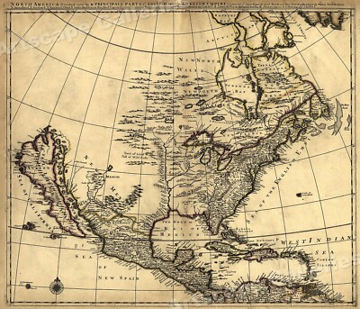
$5.95 Shipping Condition: New Location: Las Vegas, United States North America 1685 Size: 24" x 28" 61 cm x 86 cm) x Also Available in from our eBay Store This is a great Classic Map originally Published circa ... more1685. This Map shows what was known of America(North America) in1685. The wording reads: North America divided into its III principall parts. Features include: New North Wales" Canada) Bay of Mexico" Gulf of Mexico) Sea of the English Empire" Atlantic Ocean) West Indian Sea" Caribbean) Sea of California" Sea of New Spain" Pacific Ocean) New Mexico" Western United States) and"Tract of Land full of Wild Bulls" Great Plains) This poster. Which evokes the vivid images of a simpler time, is a custom reproduction printed on 68lb Heavyweight Enhanced Matte Art Paper. This Historic Art Print is suitable for framing. Mounting or direct display on any wall! 000 Artscape Galleries/ Posters Past More Prints and Posters Available from our eBay Store! Shipping price includes delivery confirmation. We combine shipping for multiple purchases- add $1.00 for each additional poster. All posters are professionally packaged to ensure that they arrive safely and undamaged: Your poster is first rolled and inserted into a plastic sleeve before being placed into a Heavy-Duty mailing tube for delivery. We stand behind the quality of every poster. If you are not satisfied with your purchase. Please contact us within 30 days to arrange for either an exchange or a full refund. gsrx_vers_468(GS 6.4(468)
Buy It Now
$6.95 Shipping Location: Dover, United States Chicopee Falls. Issued 1912, Springfield, Massachusetts by Richards Map Co. Original center fold as issued.
Buy It Now
$5.95 Shipping Condition: New Location: United States Each of our prints are custom reproductions printed on 68lb Heavyweight Enhanced Matte Art Paper. These Historic Art Prints are suitable for framing, ... moremounting or direct display on any wall! “Vibrant and bright!
Buy It Now
$6.95 Shipping Location: Dover, United States Mid-20th century lithographed campus map overprinted in red. Harvard University in Cambridge, Mass.

$7.75 Shipping Location: Palm Harbor, United States An ORIGINAL antique map of The UNITED STATES from Mitchell's New Intermediate Geography Atlas. 1878. The States and Territories are individually hand ... morewater colored. The route of the original Transcontinental Railroad is shown in bold ink while proposed routes of the next 2 transcontinental railroads are shown crossing the Pacific Northwest and the Southwest are shown in lighter ink. The Dakotas are still shown as a single large DAKOTA TERRITORY while Oklahoma was known as the INDIAN TERRITORY at the time. The names of dozens of Indian Tribes are located throughout the West. The map measures 19 by 12 inches. This ORIGINAL antique map is guaranteed over 130 years old. A rare and desirable map from the time period. I do not sell reproductions. Just honest maps at honest prices. Discounted shipping too. NO International shipping. NO exceptions. All items shipped within 2 business days after payment. If you have not received an item in a reasonable amount of time please email me. It has been delayed by the Post Office. I also accept returns on ANY item for ANY reason, please email me I am very easy to work with. Feedback is not the same thing as an email, please email first. On Oct-19-07 at 13:06:06 PDT. Seller added the following information:
Free Shipping Location: San Antonio, United States This Map was removed from a 1901 Cram's Atlas of the World. The map is not " new " or in " new " condition, it was printed in 1901. ~ CRAM1901/071122. ... moreIncluding Hundreds of RareCivil War. The full page is approx.
Buy It Now
Free Shipping Location: Augusta, United States "An Authentic Original Map Not A Reproduction".
$6.00 Shipping Location: Carefree, United States ORIGINAL 1899 COLOR MAP OF CANADA. ALSO SHOWN ARE MOUNTAIN RANGES, HUDSON BAY AND PART OF THE NORTHERN UNITED STATES AND ALASKA. MAP HAS SCALE BELOW TITLE.
Buy It Now
$4.99 Shipping Location: Fairview, United States It is by Delamarche from his. Atlas de Geographie Physique, Politique, et Historique" published in Paris, 1858. Condition: It is in Good to Very Good ... morecondition for its age, basically as seen in the pics, blank on the reverse, with original hand coloring and a centerfold as issued, the paper is still very good and flexible, not brittle.
Buy It Now
$4.99 Shipping Location: Fairview, United States A copy of the original title page with the date is included for authenticity. It is not mounted nor matted, being sold as a single sheet as seen in the ... moremain pic. Condition: The map is in Good condition for its age with overall tonal ageing, blank on the reverse, printed on strong cotton based paper.
Buy It Now
Free Shipping Location: San Antonio, United States This Map was removed from a 1861 Atlas and is in good acceptable condition. This map is not " new " or in " new " condition, it was printed in 1861. Including ... moreHundreds of RareCivil War. pencil marks & brittle paper from over 160+ years of aging.
Buy It Now
$5.95 Shipping Condition: New Location: Las Vegas, United States Year: 1823. This is a great Classic Map originally Published circa 1823. “Vibrant and bright! Pic does not do it justice.looks amazing!”. Each of our ... moreprints are custom reproductions printed on 68lb Heavyweight Enhanced Matte Art Paper.
Buy It Now
$4.59 Shipping Location: Greenacres, United States Work on the "straight cut" was completed in 1857. It was compiled under the direction of Captain John Williams Gunnison, Civil Engineer and U.S. Harbor ... moreAgent. It was published in a report by the President of the United States to the First Session of the 33rd Congress, Washington, D.C., 1853.
Buy It Now
$9.00 Shipping Location: Cambridge, United States Original print from "Hammond's Standard Atlas and Gazetteer Of The World" Hardcover first edition book 1938. Great antique condition with less than typical ... morepaper wear. One edge is raw cut. Opposite side may or may not have prints or text which may or may not be related to one shown.
Buy It Now
Free Shipping Location: Kennebunkport, United States This Map was removed form an 1856 Atlas and is in good acceptable condition. 160 years of aging. Study the photos carefully, this is the actual map you. ... morewill receive. The page is approx 16 1/2" x 13 1/2" and blank on it's backside.
Buy It Now
$5.55 Shipping Location: Cambridge, United States One edge is raw. Opposite side may or may not have prints or text which may or may not be related to one shown. Your opinion may differ.
Buy It Now
$5.95 Shipping Condition: New Location: United States Year: 1846 - 47. shows a bird’s eye view as it looked in the mid 19th century. San Francisco, California. These Historic Art Prints are suitable for framing, ... moremounting or direct display on any wall! San Francisco 1846-7.
$6.05 Shipping Location: Schwenksville, United States With letter of the Chief of Engineers, report of a preliminary examina- tion of Cape Lookout harbor of refuge, North Carolina. Lookout harbor of refuge, ... moreNorth Carolina. Very respectfully. neers, of the results of a preliminary examination of Cape Lookout.
Buy It Now
$5.61 Shipping Location: Georgetown, United States Picture Map of the Civil War. This is a well preserved, nice-looking example with pleasing highlighted examples of the battles and actions that occurred ... moreduring the Civil War, years 1861 – 1865. This map is clean and free of issues.
Buy It Now
Free Shipping Location: Anaheim, United States One City Map that is production folded. Map Publisher: RAND-McNALLY. Map is folded. Neighboring Communities. Port Washington.
Buy It Now
Free Shipping Location: San Antonio, United States This Map was removed from a 1881 School Geography Book and is in good acceptable condition. This map is not new or in new condition, it was printed in ... more1881. Including Hundreds of RareCivil War.
Buy It Now
Free Shipping Location: Schertz, United States This Map was removed from a 1911 Plat Atlas and is in good acceptable condition. The map is not " new " or in " new " condition, it was printed in 1911. ... moreOnly Authentic Originals. Study the photos carefully, this is the actual map you will receive.
Buy It Now
$5.95 Shipping Condition: New Location: Las Vegas, United States 1660 Map of New York (New Amsterdam - Manhattan). Year: 1660 (redrafted in 1916). Each of our prints are custom reproductions printed on 68lb Heavyweight ... moreEnhanced Matte Art Paper. These Historic Art Prints are suitable for framing, mounting or direct display on any wall!
Buy It Now
$9.95 Shipping Location: Newport, United States Offered is an original late 1800's map of the City of Newport,Rhode Island. This is original, not a copy. It measures 33' wide by 22 1/2" high and is ... morein good condition for its age. The map represents a portion of Ward 2., The plats contain some of the names of each owner as well as numbers which I assume represent the size of the lot. It is possible that your lot is included on this map which would make a very nice item to frame and display in your home. Check it out if you have time. I only ship within the United States. If you are local, I can deliver it to you or you can pick it up at my residence. Thank you.
Buy It Now
Free Shipping Location: Schertz, United States This Map was removed from a 1875 IOWA State Plat Atlas and is in very good condition. The map is not " new " or in " new " condition, it was printed in ... more1875. Study the photos carefully, this is the.
Buy It Now
$4.99 Shipping Location: Fairview, United States Condition: The map is in Very Good condition with light tonal ageing. The pics are of the actual map. An Authentic Antique Map: Not a Modern Reproduction!
Free Shipping Location: Kennebunk, United States This Map was removed from a 1917 Atlas and is in good acceptable condition. Study the photos carefully, this is the actual map you. Only Authentic Originals.
Buy It Now
$5.95 Shipping Condition: New Location: Las Vegas, United States As settlers spread west, Schönberg's map of Texas shows the growing state of Texas and the contemporary counties as of 1866. Year: 1866. Schonberg's map ... moreof Texas. “Vibrant and bright! Pic does not do it justice.looks amazing!”.
$25.00 Shipping Location: Perugia, Italy This map was originally published in 1833 by Chapman & Hall in S.D.U.K. Atlas. It was engraved by John Walker of J. and C. Walker. Date: 1833 ( dated ... more). The admirable goal of the Society was to distribute useful information via a series of publications to the English working and middle classes.
Buy It Now
Free Shipping Location: North Wales, United States 1911 ANTIQUE RAND MCNALLY NEW IDEAL ATLAS MAP-UNITED STATES EXPANSION ORIGINAL ANTIQUE ATLAS MAP PLEASE SEE PHOTOS AS PART OF THE DESCRIPTION CONDITION: ... moreMAP IS IN GOOD CONDITION. SIZE: APPROXIMATELY 10" X 13" SHIPPING: U.S. FIRST CLASS RATE - $7.00 - ANY ITEM WHICH SELLS FOR OVER $100 WILL REQUIRE INSURANCE WE COMBINE SHIPPING FOR MULTIPLE WINS. THANK YOU FOR YOUR INTEREST IN OUR AUCTIONS!.
Buy It Now
$7.00 Shipping Location: North Wales, United States 1864 ANTIQUE JOHNSON ATLAS MAP OF ILLINOIS-UNITED STATES-HAND COLORED ORIGINAL ANTIQUE ATLAS MAP PLEASE SEE PHOTOS AS PART OF THE DESCRIPTION CONDITION: ... moreMAP IS IN GOOD CONDITION. SIZE: APPROXIMATELY 10" X 13" SHIPPING: U.S. FIRST CLASS RATE - $7.00 - ANY ITEM WHICH SELLS FOR OVER $100 WILL REQUIRE INSURANCE WE COMBINE SHIPPING FOR MULTIPLE WINS. THANK YOU FOR YOUR INTEREST IN OUR AUCTIONS!.
Buy It Now
$7.00 Shipping Location: North Wales, United States 1875 CORNELL ATLAS MAP-PACIFIC STATES & TERRITORIES-UNITED STATES-HAND COLORED ORIGINAL ANTIQUE ATLAS MAP PLEASE SEE PHOTOS AS PART OF THE DESCRIPTION ... moreCONDITION: MAP IS IN GOOD CONDITION. SIZE: APPROXIMATELY 14" X 21" SHIPPING: U.S. FIRST CLASS RATE - $7.00 - ANY ITEM WHICH SELLS FOR OVER $100 WILL REQUIRE INSURANCE WE COMBINE SHIPPING FOR MULTIPLE WINS. THANK YOU FOR YOUR INTEREST IN OUR AUCTIONS!.
Buy It Now
Free Shipping Location: Schertz, United States This Map was removed from an 1886 NATIONAL Atlas and is in good acceptable condition. The map is not " new " or in " new " condition, it was printed in ... more1886. The map is not dated. Study the photos carefully, this is the actual map you will receive.
$16.00 Shipping Location: Poland Date of issue: ca 1800. THIS IS AN ORIGINAL MAP, NOT A RECENT COPY OR REPRODUCTION. by Tardieu Ambroise, publ. HAND COLOURED.
Buy It Now
$5.95 Shipping Condition: New Location: Las Vegas, United States Year: 1851. Canton 1885. New York City 1851. These Historic Art Prints are suitable for framing, mounting or direct display on any wall! New York City, ... moreNew York. “Vibrant and bright! Pic does not do it justice.looks amazing!”.
Buy It Now
$8.00 Shipping Location: North Wales, United States 1872 ANTIQUE ASHER & ADAMS ATLAS MAP-MAINE-UNITED STATES-HAND COLORED-RARE ORIGINAL ATLAS MAP PLEASE SEE PHOTOS AS PART OF THE DESCRIPTION CONDITION: ... moreMAP IS IN GOOD CONDITION. SIZE: APPROXIMATELY 14" X 17.5" SHIPPING: U.S. FIRST CLASS RATE - $8.00 - ANY ITEM WHICH SELLS FOR OVER $100 WILL REQUIRE INSURANCE WE COMBINE SHIPPING FOR MULTIPLE WINS. THANK YOU FOR YOUR INTEREST IN OUR AUCTIONS!.
Buy It Now
$6.95 Shipping Location: Dover, United States Issued 1833, New York by E. & G.W. Blunt. Engraved by Hooker. Any age flaws mostly minor and easy to overlook or forgive. Original fold lines as issued. ... moreEarly 19th century engraved nautical map with attractive hand color.
Buy It Now
Free Shipping Location: Schertz, United States This Map was removed from a 1904 Chemung County Plat Atlas and is in very good condition. The map is not " new " or in " new " condition, it was printed ... morein 1904. Study the photos carefully, this is the actual map you will receive.
Buy It Now
$5.99 Shipping Condition: Used Location: Maryville, United States FROM THE 1885 BOOK "THE SOLDIER IN OUR CIVIL WAR" BY FRANK LESLIE, WASHINGTON. CURRIER & IVES CIVIL WAR LITHOGRAPHS. KURZ & ALLISON CIVIL WAR PRINTS. ... more+ MUCH MORE. MARVELOUS OLD PRINT FOR FRAMING GREAT GIFT FOR THE CIVIL WAR ENTHUSIAST.
Buy It Now
$6.90 Shipping Location: Jasper, United States Known for being one of the oldest and most respected publishing houses in Germany, the Bibliographisches Institut specialized in authoritative reference ... moreworks. I believe they deserve to be appreciated by fellow collectors rather than gathering dust in storage.
Buy It Now
$20.70 Shipping Location: Union, United States This is a hand-colored map, published in 1864. Year: 1864. Country/Area/Region: Iowa and Nebraska. Publisher: A. J. Johnson. Condition: Sealed in plastic ... moreon foam board. Split down middle crease. Light toning, minor chipping.
Buy It Now
$5.00 Shipping Location: Aransas Pass, United States
|
|
|
In
|
Mean Annual Temperature United States 1888 antique color lithograph map
Mean Annual Temperature Chart of the United States Issued 1888. New York Fine original antique color lithograph map. Printed on quality paper which retains its inherent structural flexibility and soundness. In VG or better condition. Minor light surface age wear, and some uniform age toning as typical, overall the map remains clean and attractive, well worthy of ownership[note: we grade very conservatively and always seek to disclose any noteworthy flaws] The printed area remains visually pleasing. A nice impression of an interesting antique map. Any minor defects along the sheet edges and in the margins may be seen in the photos. Sheet measures c. 12" W x 9 5/8" H. Engraved area measures c. 10 3/4" W x 7 5/8" H. Original fold line as issued. 48648] Guaranteed Authentic! We do not sell modern reprints. Condition All of ... moreour items are original antique pieces and it is important to keep in mind that many of them have been around for 100 years or more. Individual pieces may have seen many owners and been handled many times over the course of their existence and as a result each piece has developed a history of it's own. Short edge splits(often repaired with archival tape) Foxing, discoloration, etc. are all things to expect on items of this type. They rarely distract from the piece and often add to the overall character of the item. Keep in mind when you receive your item that you are not handling a modern copy, you are holding a piece of history, an item that has been around for a very long time and will, with proper care, be around for a long time to come. We try to note any significant flaws in the description, but less noticeable or common characteristics may not be mentioned. As we are a US based company all of our measurements are in Inches. If you need the size in Centimeters please multiply the supplied measurement by 2.53. Payment and Shipping We happily accept PayPal! Payment is appreciated within 5 days of invoicing. Once payment has been received we do our best to make sure all ord
|
|
|
South United States Lines Operation c.1890s huge detailed antique Civil War map
Southern United States Issued c.1891-95. Washington, D.C. by the US Government Printing Office. Printed by Julius Bien& Co. Lithographers, N.Y. Published under the direction of Daniel S. Lamont. Secretary of War. Originally issued in the"Atlas to Accompany the Official Records of the Union and Confederate Armies" Which was issued in parts to subscribers over a period of years, but is sometimes found bound up later into atlas volumes. This oversize and attractive lithographed 19th century sheet depicts in great detail the specific events and locations of the Civil War battles or regions depicted. Astoundingly detailed. With an emphasis upon precision and accuracy, attempting to capture visually and cartographically the regions and battles depicted. Unlike topographical maps or state maps of the era issued by most cartographers. ... moreThe underlying premise of these Civil War maps was to depict the cartography as it specifically related to events of the Civil War. Thus, individual battles, small forts, troop movements, local rail lines, panoramic views, etc. are often rendered and explained with precision in a manner quite unique. Also, the very large format of the sheet allows for a level of detail which makes the map perfect for display or study by a Civil War buff, since the detail it contains is to be found almost no where else on this scale. In Good+ to VG. Mostly clean condition. some light damp staining across the blank margin which will disappear once matted and s ome light minor age-wear- typical for maps of this era. And in no way offensive or severe. Overall a pleasing example of this interesting map. Which is well worthy of display. Elephant folio sheet measures c. 29 1/4" W x 18 1/8" H. Printed area measures c. 27" W x 13 3/8" H. Original center-fold line as issued. 47415] Guaranteed Authentic! We do not sell modern reprints. Condition All of our items are original antique pieces and it is important to keep in mind that many of them have been around for 100 years or more. In
|
|
|
ANTIQUE MAP OF THE UNITED STATES HAND COLORED BY DUSSIEUX 1846
. 1846 Dussieux. Louis Paris: J. Lecoffre et Comp. From Atlas General de Geographie. Sheet app. 33.5 x 45 cm. 18 x 13 inches. Image app. 27 x 38 cm. 10.5 x 15 inches. Condition: Very good. Fold as published. All maps and prints are genuine. Authentic, published at the date stated in this listing! For better quality pictures please go to our web site: WWW.MAPANDMAPS.COM I offer a no questions returns policy. All maps and prints are genuine. Authentic, published at the date stated above. Shipping: Worldwide shipping by signed registered mail or Global Express courier . Standard Int'l Shipping means registered airmail of Europe. If you want to receive the item quickly. Ask for Expedited Int'l Shipping or a 3 days Shipping by FedEx. between $ 25.95 and $ 38.50) Shipping fee is per combined shipment. Including handling and ... moreinsurance. Free shipping worldwide if three items or more purchased. . . .
|
|
|
Antique Map-ENGLAND-UNITED KINGDOM-UK-WALES-GREAT BRITAIN-Jacob Kuyper-1880
ABOUT US VISIT OUR STORE SALES SPECIALS Antique Map-ENGLAND-UNITED KINGDOM-UK-WALES-GREAT BRITAIN-Jacob Kuyper-1880 Description: This lithographed map originates from: Wereld-atlas voor Kantoor en Huiskamer' transl: World Atlas for the office and living room) By J. Kuyper, published in 1880- 1882 in Amsterdam, The Netherlands by G. L. Funke. Artists and Engravers: Jacob Kuyper(1821- 1908) Dutch cartographer. Subject: Plate 3: Engeland' England) Condition: Good. General age related toning. Size(in cm) The overall size is ca. 19 x 24 cm. The image size is ca. 16 x 20.5 cm. Size(in inch) The overall size is ca. 7.5 x 9.4 inch. The image size is ca. 6.3 x 8.1 inch. Medium: Lithograph on a vellin type of paper. Location: C153-01 ThePrintsCollector Peter Cornelissen. Margo van Latum- van Dongen, Frank van Latum Zeeland- The Netherlands ... morePhone: +31 654 21 23 78 Worldwide free shipping on all orders. We ship within one business day upon receipt of payment. We ship by Registered Mail. Insurance is included. We guarantee our items to be genuine original. Visit our Store: we would like to invite you to review similar items in our Store or to browse through all other items in our Store. We are confident that you will find very special unique antique maps and prints in our Store. It is our privilege to have you as a customer. We accept Paypal payments and payment by bank transfer. Combined auction/ buy it now orders are possible! We will send a Paypal invoice on request! THE PRINTSCOLLECTOR GUARANTEES ITEMS SOLD THROUGH EBAY ARE GENUINE ORIGINAL ANTIQUE PRINTS IN THE CONDITION/TECHNIC AS DESCRIBED. ITEMS CAN BE RETURNED WITHIN 7 DAYS. Powered by
|
|
|
1922 Longman's Antique Colour Map of United States of North America in 1783
Antique Map: United States of North America- 1783 Page size 8¼" x 6¾" 21cm x 17cm) approximate(including the margins) Guaranteed a 91 year old original page. SOURCE: dis-bound book: Atlas of English History- Edited by Samuel Rawson Gardiner D.C.L. LL.D. 1922. No text on reverse side- Ideal for mounting and framing! Will be sealed in a clear cellophane bag and sent 1 st Class Recorded/Signed For(trackable) in rigid'Do Not Bend' cardboard packing. If. For any reason you are not happy with your purchase we will refund/exchange, guaranteed!
|
|
|
RARE antique 1892 The United States Map Puzzle by PARKER BROTHERS
THIS IS NOT the 1907 or the 1915 The United States Map Puzzle by Parker Brothers. But the RARE 1892 The United States Map Puzzle by Parker Brothers. Salem, MA. This antique 55 piece wood backed color lithographed map surface jigsaw puzzle comes with its original and authentic colorful and ornate design pasteboard box and its uncolored instruction map printed on the inside of the lid. It's interesting to note that the eastern half of the State of Oklahoma was still called Indian Territory on this map and is a separate puzzle piece from Oklahoma. In 1907. The Oklahoma Enabling Act specified that Indian Territory was to become part of the State of Oklahoma and the Indian Territory ceased to exist at that time. The map shows railroads in red color. It's not until years later that Parker Brothers United States puzzle maps have insets for: ... morethe Philippines. Porto Rico(Puerto Rico) and the US Virgin Islands, Alaska and Hawaii. This particular map does not have any insets, as it was manufactured before the 1898 Spanish-American War. This 121 year old map puzzle is complete and in great condition for it being a lithographed paper map over wood. It's very difficult to find this map puzzle complete and in such a condition as this one. On past sales. Examples of this highly collectable map puzzle(with some missing pieces) have sold for upwards of $300. CONDITION: Three small tips are broken: the bottom tip of Maine. The upper tip of West Virginia, and the lower tip of Lake Huron. We are enclosing a tip that belongs to one of those. So there are only two small tips missing. Also, we are including the following pieces: the piece with the letter"C" of Pacific Ocean, the piece with letter"N" of Atlantic Ocean, and a rectangular piece of Idaho. They're all easy to repair. The lid is fragile and damaged as is the box and both have remnants of tape affixed. The interior of the lid has remnants of what appears to be two temporary kid tattoos(at each extreme of the uncolored map, upper part) On the
|
|
|
1858 Chambers Large Antique Map of The United States, showing Slave States
Û4££°ßÓ*6- 3=2$8/3% ZLBCK²ÐÀ000eW[Ai0`00ShMSO[^m00Yc^GW0000Ml0B@Ejc00000000000000000000El^- Helpful Links: Company Details- About ME View seller's other items Cartographer's Profile Ask Seller a q uestion Return Policy We have over 2.000 items for sale on our Ebay stores site. Please click here to enter the stores and use the search engine to the left to search specifically for maps. Prints, Atlases on the Classical Images Stores. Thank you United States North America This large fine hand coloured original antique map of The United States in the mid 19th century was published in 1858 by William& Robert Chambers. London. This is a significant map of the United States just prior to the civil war and just before the inclusion of the western States into the union which are still terrritories. ... moreMinnesota is the last western are shown as a state. Large territories such as Nebraska& Utah within the map will soon be divided into other states such as Nevada and the Dakotas. Also noted on the map below the title is the statement"Northern Limit of Slavery in Western States shown by Mason& Dixon Line" Ref: M&B; Tooley) Please note all items auctioned are genuine. We do not sell reproductions. A Certificate of Authenticity(COA) can be issued on request. Condition Report General Description: Paper thickness and quality: Heavy& stable Paper color: White Age of map color: Original Colors used: Pink. Yellow, green, yellow, orange General color appearance: Authentic Paper size: 20i n x 12 1/2 i n( 510 mm x 320 m m) P late size: 20i n x 12 1/2 i n( 510 mm x 320 m m) Margins: Min 1in(25 m m) Imperfections: Margins: None Plate area: None Verso: Mounted on archival heavy paper Overall Quality(in Bold) Perfect/ Fine/Very Good/Good/Fair/Poor Payment Methods Visa MasterCard Bankcard* PayPal Please contact me to discuss other forms of payment Please also contact me before the end of the auction if you would like to discuss payment by installments over an agr
|
|
|
1834 RARE Antique MAP United States Canada RARE INDEX MAP 1830 Census SLAVE POP
If you love fine. Rare and beautiful books, prints, vintage movie posters, rare affiches, photos, and other works of extraordinary ephemera PLEASE SAVE ME in your favorites! Scroll down for more HIGH RESOLUTION images. And don't forget to CHECK MY OTHER LISTINGS for more valuable books and ephemera! please read this listing carefully AND review the many high resolution photos* shipping includes insurance and domestic delivery confirmation* RARE ANTIQUE MAP IN VERY GOOD CONDITION* NORTH AMERICA RARE United States/Canada Index Map Richly detailed. Showing population figures from 1830 census including slave and free population by state 1834 LONDON 1834. Society for the Diffusion of Useful Knowledge. London. 1834 Rare US and Canada SDUK Index Map showing data from 1830 census including slave population by state. Beautiful map. Excellent condition, ... morehighly detailed, complete and untorn. Printed 1834 in London. Measures approx 16 1/4 x 13 1/2 inches. Lightly age toned(photos make it look more toned than it actually is) occasional(very) minor foxing mostly to margins. Society for the Diffusion of Useful Knowledge(SDUK) North America Index Map. Genuine antique, not a reproduction. Please see the many photos for detailed condition. I SHIP WORLDWIDE! Please note my 100% positive feedback and bid with confidence. Some of my recent feedback: One of my favorite sellers. Everything A++ as advertised. Thanks again! Truly the kindest. Most hospitable seller on eBay! Thanks for everything! Amazing quality. Just as described. Packaged very securely. Book mint and very fast shipment. Excellent transaction Awesome seller. One of the best on ebay. Thanks again! Accurate description. Excellent packing and fast delivery What a beauty! History& charm. Fast shipping
|
|
|
Matted 113-yr-old Antique Color Map UNITED STATES
Auction Wizard 2000 Listing Template- AW2KLOT#5444 tincuptom Auctions Matted 113-yr-old Antique Color Map UNITED STATES Custom Matted.8 x 10 inch. Frame Ready Original 1900 Rand McNally Map Excellent Condition Crescent Mat measures 8 x 10 inches with a 6 1/2 x 5 1/4 inch map cut-out Fits and 8 x 10 inch frame The USA Shipping is First Class mail. View my other listings for more antiques. Shipping and handling in the USA is $0.00. Payments are due in 7 day. You may pay by Paypal only. Please E-mail for International Shipping rates.
|
|
|
1899 Antique UNITED STATES MAP Beautiful Vintage 1800s MAP Atlas Map
VINTAGE MAP OF THE UNITED STATES This is an original. Not reproduction, vintage map which was carefully removed from an atlas. This map measures approximately 9" by 12.5" and is in very good condition. There is index beyond the map. Your item will be packaged in a plastic sleeve. Within a cardboard mailing tube. We happily combine purchases to save on shipping fees. Please email with questions. We will answer your email promptly! Please visit our ebay store. Plaindealing Vintage Paper. Be sure to add me to your! Check out my! Powered by The free listing tool. List your items fast and easy and manage your active items.
|
|
|
1890 USA UNITED STATES of AMERICA NEW YORK CITY PLAN Antique Map
Normal 0 21 false false false MicrosoftInternetExplorer4 1890 USA UNITED STATES of AMERICA NEW YORK CITY PLAN Antique Map D E S C R I P T I O N Normal 0 21 false false false MicrosoftInternetExplorer4 THERE ARE NOT ANY SPOTS OR STAINS ON THE PRINT! THIS APPEARS DUE TO THE SCANNER. S OME PART OF THE IMAGE MAY BE CUT DURING THE SCANNING! Normal 0 21 false false false MicrosoftInternetExplorer4 Normal 0 21 false false false MicrosoftInternetExplorer4 Due to the scanner the image is more yellow than in reality. There is a light stripe in the middle of the page. Caused by the scanner. In reality there is a fold in the center. This is an original old German map– a double page book plate. This original. Authentic antique map was a part of old German book. This is NOT a modern reproduction! VERY DECORATIVE. PERFECT FOR FRAMING! The map is printed ... morein Leipzig. Germany, by the Bibliographishes Institut in 1890 SIZE– apr. 12’ 10’ inches– perfect for framing. There is a fold in the center– the print was folded inside the book. The image presents the area of the print. Which will be visible when it is framed. ABOUT THE CONDITION– please check the scan arefully. SHIPPING We use a tube in order to protect the prints. We ship registered only. For USA and Canada– registered with priority. FEES- $ 8 for 1-3 prints in a tube. $ 19 for up to 20 prints. PAYMENTS Please pay by PAYPAL in a reasonable time after your purchase. We hate to open“non paid item” disputes or cases. But life is not only pleasure L. PLEASE NOTE! After reading this description. If there are any questions. Please ask us BEFORE bidding! If there is a problem with your item before or after it’s receiving. Please contact us ASAP. We’ll give our best to resolve the problem in a friendly manner.
|
|
|
United States Nevada California Texas 1893 antique lithograph hand color map
United States Issued 1893. Jacksonville, Illinois by Tunison Fine original antique lithographed map. With original hand color and a lovely decorative border. Printed on quality paper which retains its inherent structural flexibility and soundness. In near VG or better condition. Minor light surface age wear, but the image remains clean and very attractive[note: we grade very conservatively and always seek to disclose any noteworthy flaws] The printed area remains visually pleasing. A nice impression of an interesting antique map. Any minor defects along the sheet edges and in the margins may be seen in the photos. Sheet measures c. 21 7/8" W x 13 3/4" H. Engraved area measures c. 19 7/8" W x 12 3/4" H. Original fold line as issued. 46525] Guaranteed Authentic! We do not sell modern reprints. Condition All of our items ... moreare original antique pieces and it is important to keep in mind that many of them have been around for 100 years or more. Individual pieces may have seen many owners and been handled many times over the course of their existence and as a result each piece has developed a history of it's own. Short edge splits(often repaired with archival tape) Foxing, discoloration, etc. are all things to expect on items of this type. They rarely distract from the piece and often add to the overall character of the item. Keep in mind when you receive your item that you are not handling a modern copy, you are holding a piece of history, an item that has been around for a very long time and will, with proper care, be around for a long time to come. We try to note any significant flaws in the description, but less noticeable or common characteristics may not be mentioned. As we are a US based company all of our measurements are in Inches. If you need the size in Centimeters please multiply the supplied measurement by 2.54. Payment and Shipping We happily accept PayPal! Payment is appreciated within 5 days of invoicing. Once payment has been received we do our best to make sure all orders are shi
|
|
|
United States Texas California 1885 antique color map
United States Issued 1885. Chicago, Rand, McNally& Co. Fine original antique offset color map. Printed on quality paper which retains its inherent structural flexibility and soundness. In near VG or better condition. Minor light surface age wear and some faint age toning as typical but the map remains clean and very attractive[note: we grade very conservatively and always seek to disclose any noteworthy flaws] Text on verso as issued. The printed area remains visually pleasing. A nice impression of an interesting antique map. Any minor defects along the sheet edges and in the margins may be seen in the photos. Sheet measures c. 21 1/4" W x 14 7/8" H. Engraved area measures c. 19 3/4" W x 12 3/4" H. Original fold line as issued. 46515] Guaranteed Authentic! We do not sell modern reprints. Condition All of our items ... moreare original antique pieces and it is important to keep in mind that many of them have been around for 100 years or more. Individual pieces may have seen many owners and been handled many times over the course of their existence and as a result each piece has developed a history of it's own. Short edge splits(often repaired with archival tape) Foxing, discoloration, etc. are all things to expect on items of this type. They rarely distract from the piece and often add to the overall character of the item. Keep in mind when you receive your item that you are not handling a modern copy, you are holding a piece of history, an item that has been around for a very long time and will, with proper care, be around for a long time to come. We try to note any significant flaws in the description, but less noticeable or common characteristics may not be mentioned. As we are a US based company all of our measurements are in Inches. If you need the size in Centimeters please multiply the supplied measurement by 2.54. Payment and Shipping We happily accept PayPal! Payment is appreciated within 5 days of invoicing. Once payment has been received we do our best to make sure all orders are shi
|
|
|
United States Apr 1865 Confederate c.1890s huge detailed antique Civil War map
Map of the United States Showing the Boundaries of the Union and Confederate Geographical Divisions and Departments April 9. 1865 Issued c.1891-95. Washington, D.C. by the US Government Printing Office. Printed by Julius Bien& Co. Lithographers, N.Y. Published under the direction of Daniel S. Lamont. Secretary of War. Originally issued in the"Atlas to Accompany the Official Records of the Union and Confederate Armies" Which was issued in parts to subscribers over a period of years, but is sometimes found bound up later into atlas volumes. This oversize and attractive lithographed 19th century sheet depicts the specific boundaries of the United States at this date of the Civil War. It shows headquarters. Mail routes(pony express) forts and main roads.Confederate areas are highlighted in green. In near VG. Mostly clean condition. ... moreMap likely displays a few short minor edge-splits in the wide blank margins, all of which will disappear once the map is matted for display. Also some light minor age-wear- typical for maps of this era, and in no way offensive or severe. Overall a pleasing example of this interesting map. Which is well worthy of display. Elephant folio sheet measures c. 29 1/4" W x 18 1/8" H. Printed area measures c. 27" W x 13 3/8" H. Original fold line as issued. 47304] Guaranteed Authentic! We do not sell modern reprints. Condition All of our items are original antique pieces and it is important to keep in mind that many of them have been around for 100 years or more. Individual pieces may have seen many owners and been handled many times over the course of their existence and as a result each piece has developed a history of it's own. Short edge splits(often repaired with archival tape) Foxing, discoloration, etc. are all things to expect on items of this type. They rarely distract from the piece and often add to the overall character of the item. Keep in mind when you receive your item that you are not handling a modern copy, you are holding a piece of history, an
|
|
|
Mitchell'1867 antique engraved physical map of the United States
This is an original engraved antique 1867 physical map of the United States no.13 pubplished by Mitchell drawned and engraved by J.M. Atwood. Philadelphia. It was removed from the geography book being very careful to cause liitle damage. It was difficult due to the very poor condition of the book when found recently.It has two colors added to the engraving. I don't know if it was hand-colored or stencil applied. The colors are a light blue/green and light lemon. very striking and not too much. Across the top is a line of engravings of mountain peaks and their highest elevation. Is also contains isothermal lines.It measures 12 1/4 by 9 1/2 inches overall and the black line image measures8 1/4 by 11 inches. It has the original binding holes, it has not been trimed and has a few 1/4 inch tearson bottom right edge. It is in very good condition ... moreespecially noting it come from an educational geography book.This is the first listing of several to be up for sale.
|
|
|
Old 1873 Antique MAP of the United States - ZOOLOGICAL Divisions - OW GRAY
Old 1873 Antique MAP of the United States- ZOOLOGICAL Divisions- OW GRAY. Original 1873 map published by O.W. Gray. SIZE: Measures about 14 1/2" x 17 1/4" CONDITION: Overall Very Good. 100% Guaranteed old and original. Please see my other auctions today- shipping may be combined on multiple purchases. Complete customer satisfaction is my#1 goal. I will make every effort to deliver your purchase quickly. Safely, and at the lowest shipping cost possible. I ask from my customers just a few simple things in return. BEFORE BIDDING: Please review the item description. Photos, shipping costs, and my return policy(I accept returns for any misrepresented item with regards to condition, age, etc. but not for reasons such as change of heart, or because the buyer did not read the description, photos, shipping costs, etc. If you have any questions ... moreregarding the listing- please email me before bidding. AFTER PURCHASE: Prompt payment is appreciated. If you are buying multiple items- please wait/ or ask for a combined invoice. I will combine shipping on multiple items to ship at the lowest cost possible. I usually ship within one to two business days after receipt of payment- and the tracking# is automatically posted to eBay- so you can track your package. And know that it is on the way. Tracking of items enroute: sometimes tracking shows progress along the way, sometimes it is not updated until delivery. Please understand that I can not provide any further information than what tracking shows regarding where the package is or when it will arrive. International deliveries have extreme variability and are often subject to customs delays- so please be patient. I will ALWAYS provide a 100% refund for any lost package. AFTER RECEIPT: Please let me know right away if you have any questions or concerns. I NEVER sell reproductions- so if you have a concern over authenticity- email me. And I will explain to the best of my ability how I verified the age and originality of the item. Several items I sell are from old
|
|
|
1855 CORNELL'S "UNITED STATES" ANTIQUE MAP, back is "NEW ENGLAND" & "CITIES"
THIS MAP. AS WITH ALL MY ITEMS CAN BE SEEN AT MY ANTIQUE STORE, 20 MECHANIC STREET, CAMDEN MAINE. PLEASE NOTE: PAY ATTENTION TO THE CONDITION SECTION BELOW. YOU ARE BIDDING ON ONE MAP PER LISTING. You are bidding on ONE 1855 CORNELL'S"UNITED STATES" ANTIQUE MAP(first 6 pictures) One half of back is"NEW ENGLAND OR EASTERN STATES" pictures 7 THRU 9) One half of back is"PRINCIPLE CITIES OF THE UNITED STATES" last picture) THIS IS AN ORIGINAL MAP. NOT A REPRODUCTION. This map is came from Cornell's High School Geography. A cross the bottom left is: Entered according to Act of Congress in the Year 1855 by S. S. Cornell. In the Clerk's Office of the District Court, for the Southern District of New York" Across the bottom center is: NEW YORK. D. APPLETON& CO. 346& 348 BROADWAY" Hand colored ... moreat time of publishing. Very interesting because areas are so different today. Shows rivers. Mountains and major bodies of water where applicable. YOU ARE BIDDING ON ONE MAP PER LISTING. PRINTED IN: USA DATE: 1855 map. SIZE: Paper is: 22" wide by 13-1/2" tall(front side) Back side dimensions are reversed from front side. CONDITION: NOTE: This map is in good condition BUT but is has quite a bit of foxing(brown spots) and some surface dirt. PLEASE CHECK PICTURES. YOU CAN ZOOM IN ON PICTURES. PLEASE ASK IF YOU WANT HIGHER RESOLUTION PICTURES. PLEASE BE SPECIFIC. THANKS. BETTER PICTURES: EMAIL ME IF YOU WANT HIGHER RESOLUTION AND/OR MORE SPECIFIC PICS AND DESCRIPTIONS. I will need your internet contact info. Mine is: Bbobb. At. Roadrunner. Dot. Com. SHIPPING& HANDLING: PLEASE NOTE: I SHIP ONCE A WEEK. SHIPPING TO THE 48 CONTIGUOUS UNITED STATES WILL BE $8.00 VIA U.S.P.S. PRIORITY MAIL. OTHER MAILING AREAS WILL BE DETERMINED BY DISTANCE AND TYPE REQUESTED. I ship via U.S.P.S. only. PLEASE CHECK OUT MY OTHER AUCTIONS.
|
|
|
United States Texas Oregon Territory 1847 antique wax engraved hand color map
United States(showing western Territories) Issued 1847. New York by Morse Interesting original antique wax engraved(cerographic) map. With original hand color. Printed on quality paper which retains its inherent structural flexibility and soundness. In Good or better condition. Minor light surface age wear, small scattered foxing and staining across the sheet, a few small stitch holes along the center fold line, as well as a slight age waviness, and some creases in the corners, overall the map remains attractive and well worthy of ownership[note: we grade very conservatively and always seek to disclose any noteworthy flaws] The printed area remains visually pleasing. A nice impression of an interesting antique map. Any minor defects along the sheet edges and in the margins may be seen in the photos. Sheet measures c. 19 5/8" W x 11 5/8" ... moreH. Engraved area measures c. 15" W x 10 1/4" H. Original fold line as issued. 49317] Guaranteed Authentic! We do not sell modern reprints. Condition All of our items are original antique pieces and it is important to keep in mind that many of them have been around for 100 years or more. Individual pieces may have seen many owners and been handled many times over the course of their existence and as a result each piece has developed a history of it's own. Short edge splits(often repaired with archival tape) Foxing, discoloration, etc. are all things to expect on items of this type. They rarely distract from the piece and often add to the overall character of the item. Keep in mind when you receive your item that you are not handling a modern copy, you are holding a piece of history, an item that has been around for a very long time and will, with proper care, be around for a long time to come. We try to note any significant flaws in the description, but less noticeable or common characteristics may not be mentioned. As we are a US based company all of our measurements are in Inches. If you need the size in Centimeters please multiply the supplied measurement
|
|
|
United States Territories Mormon Settlement 1853 antique engraved hand color map
United States and Canada(Showing numerous Western Territories) Issued 1853. New York by Daniel Burgess& Co. Interesting original antique engraved map. Note the size and shape of Territories of Washington. Oregon, Utah, New Mexico, Nebraska, etc. Beside the Great Salt Lake in Utah is labelled'Mormon Settlement" With original hand color. Printed on quality paper which retains its inherent structural flexibility and soundness. In Good+ to near VG or better condition. Minor light surface age wear, small scattered foxing and staining across the sheet, as well as a slight age waviness, and some creases in the corners, overall the map remains attractive and well worthy of ownership[note: we grade very conservatively and always seek to disclose any noteworthy flaws] The printed area remains visually pleasing. A nice impression of an ... moreinteresting antique map. Any minor defects along the sheet edges and in the margins may be seen in the photos. Sheet measures c. 18 5/8" W x 11 1/2" H. Engraved area measures c. 17 1/2" W x 10 1/2" H. Original fold line as issued. 49316] Guaranteed Authentic! We do not sell modern reprints. Condition All of our items are original antique pieces and it is important to keep in mind that many of them have been around for 100 years or more. Individual pieces may have seen many owners and been handled many times over the course of their existence and as a result each piece has developed a history of it's own. Short edge splits(often repaired with archival tape) Foxing, discoloration, etc. are all things to expect on items of this type. They rarely distract from the piece and often add to the overall character of the item. Keep in mind when you receive your item that you are not handling a modern copy, you are holding a piece of history, an item that has been around for a very long time and will, with proper care, be around for a long time to come. We try to note any significant flaws in the description, but less noticeable or common characteristics may not be m
|
|
|
United States Mormon Settlement in Utah 1853 antique engraved hand color map
United States Issued 1853. New York by Daniel Burgess& Co. Interesting original antique engraved map. Note the size and shape of Territories of Washington. Oregon, Utah, New Mexico, Nebraska, etc. Beside the Great Salt Lake in Utah is labelled'Mormon Settlement" With original hand color. Printed on quality paper which retains its inherent structural flexibility and soundness. In Poor to Fair or better condition. Minor light surface age wear, small scattered foxing and dampstaining across the sheet, as well as a slight age waviness, some creases in the corners, archival tape repairs on back at centerfold ends, overall the map remains attractive and well worthy of ownership[note: we grade very conservatively and always seek to disclose any noteworthy flaws] The printed area remains visually pleasing. A nice impression of an interesting ... moreantique map. Any minor defects along the sheet edges and in the margins may be seen in the photos. Sheet measures c. 18 5/8" W x 11 1/4" H. Engraved area measures c. 17 5/8" W x 10 5/8" H. Original fold line as issued. 49315] Guaranteed Authentic! We do not sell modern reprints. Condition All of our items are original antique pieces and it is important to keep in mind that many of them have been around for 100 years or more. Individual pieces may have seen many owners and been handled many times over the course of their existence and as a result each piece has developed a history of it's own. Short edge splits(often repaired with archival tape) Foxing, discoloration, etc. are all things to expect on items of this type. They rarely distract from the piece and often add to the overall character of the item. Keep in mind when you receive your item that you are not handling a modern copy, you are holding a piece of history, an item that has been around for a very long time and will, with proper care, be around for a long time to come. We try to note any significant flaws in the description, but less noticeable or common characteristics may not be ment
|
|
|
LARGE ORIGINAL c. 1595 ORTELIUS ANTIQUE MAP OF BRITAIN / UNITED KINGDOM
Title: Britannicarum Insularum Typus Map Maker: Abraham Ortelius Map Image Dimensions: 50.8 x 36.5cm/ 20 x 14.4 inches(width x height) Paper Dimensions: 52 x 41 cm/ 20.5 x 16.1 inches(width x height) Description This is your chance to own a genuine Ortelius map of Britain. Which is approximately 400 years old! The map. Featuring England, Scotland, Ireland and Wales, is based on information from Mercator's 1564 map of the British Isles, improved by a new outline from Saxton's 1579 map and ancient knowledge from Diodorus, Siculus, Plinius, Appianus, Tacitus, Caesar and Strabo. The map is filled with ancient place names, Hadrian's Wall, and Wall of Pius(mislabeled Severi Imp. Murus) It is richly embellished with three large cartouches and several sailing vessels. According to Marcel van den Broecke. In Ortelius Atlas Maps, approximately ... more3300 copies of this map were printed. This copy has Latin text on the verso. Abraham Ortelius( Abraham Ortels) 14 April 1527– 28 June 1598) was a Flemish cartographer and geographer. Generally recognised as the creator of the first modern atlas. The Theatrum Orbis Terrarum(Theatre of the World) Reference van den Broecke#192 Condition Browning to the map. Centrefold and narrow left and right margins reinforced on the verso. Postage The map will be sent rolled carefully in a tube. Guarantee This map comes with a money back guarantee that it is an original antique map from the late 1500s/ early 1600s.
|
|
|
United States Eastern Missouri c.1840 antique engraved old hand color map
Etats Unis(United States) Issued c.1840. Paris Scarce original antique engraved map. With original outline hand color and a beautiful New York City vignette view in the corner of the sheet. Of interest for the unusual outlines in the far west. Including a Territory of Arkansas, Territory of Missouri, as well as Indian Districts of Huron& Osages. A map many collectors will not own or be aware of. Printed on quality heavy stock paper which retains its inherent structural flexibility and soundness. In VG or better condition. Minor light surface age wear, some uniform age toning as typical and faint scattered foxing which is primarily in the blank margins, overall the map remains clean and very attractive[note: we grade very conservatively and always seek to disclose any noteworthy flaws] The printed area remains visually pleasing. A nice ... moreimpression of an interesting antique map. Any minor defects along the sheet edges and in the margins may be seen in the photos. Sheet measures c. 13 1/4" W x 10" H. Engraved area measures c. 11 1/8" W x 8 1/4" H. 50774] Guaranteed Authentic! We do not sell modern reprints. Condition All of our items are original antique pieces and it is important to keep in mind that many of them have been around for 100 years or more. Individual pieces may have seen many owners and been handled many times over the course of their existence and as a result each piece has developed a history of it's own. Short edge splits(often repaired with archival tape) Foxing, discoloration, etc. are all things to expect on items of this type. They rarely distract from the piece and often add to the overall character of the item. Keep in mind when you receive your item that you are not handling a modern copy, you are holding a piece of history, an item that has been around for a very long time and will, with proper care, be around for a long time to come. We try to note any significant flaws in the description, but less noticeable or common characteristics may not be mentioned. As we a
|
|
|
1858 United States MAP, America 22"x15" Print, Railroad, William Perris, antique
1858 MAP* A new and complete rail road map of the United States 22"x15" HIGH QUALITY GICLEE REPRODUCTION Quality by William Perris. Trim room around edges for custom framing. THIS IS AN EXACT REPRODUCTION DIRECTLY FROM THE ORIGINAL SOURCE We use archival quality papers and ink Looks amazing framed! All prints are delivered in a heavy duty poster tube for safe delivery. Customer satisfaction guaranteed! If for some reason you want to return the item. Or your print is damaged, you can return for a full refund no worries. Maine 3c0.RcmdId ViewItemDescV4,RlogId p4%60bo7%60jtb9%3Feog4d71f%2B%3E3c0-141df16feb7-0x102-
|
|
|
Antique 1856 Handcolored map South America UNITED STATES DE LA PLATA, Equater
Antique map of South America. Lots of the countries we know now are not there. Includes one country(Etats Unis de la Plata-United states of Silver? Fair condition as shown in photo. Has binding strip on the back as this was taken from an 1856 Delamarche atlas. Measures about 18.5 x 13" Buyer pays shipping. Ca residents pay sales tax. I don't ship to all countries. Please ask before bidding. I now have 2 ebay sites: Vintage Fashion Publications Lost Dog Books Powered by The free listing tool. List your items fast and easy and manage your active items. RcmdId ViewItemDescV4,RlogId p4%60bo7%60jtb9%3Fuk.rp*3A%3Cd%3Ff6%3E-141e2638529-0x103-
|
|
|
1892 Cram Atlas Map UNITED STATES WESTWARD EXPANSION * Original Antique! #63
1892 Cram Atlas Map UNITED STATES WESTWARD EXPANSION* ORIGINAL ANTIQUE! Title: UNITED STATES WESTWARD EXPANSION" By George Cram. Chicago: 1892. Size: Sheet size of map is 11" x 14.5" or 28cm x 37cm. Description: This detailed map is from George Cram's Atlas. This is an original antique. NOT a reproduction and guaranteed to be over 120 years old. Please click on my"ME" page to learn more about us. Looking for additional quality items? Check out our other auctions for more that we have listed on eBay! Condition: Very Good condition. Payment: Buyer may pay by PayPal! Shipping: Shipping prices are listed below under shipping details. Buyer to pay for shipping with free shipping on additional maps and prints shipped together not including books or large groups of maps or prints sold as one lot. Click here to view our ... moreother maps and prints. Click here to learn more about Bookable Powered by The free listing tool. List your items fast and easy and manage your active items. RcmdId ViewItemDescV4,RlogId p4%60bo7%60jtb9%3Fuk.rp*05e54c%3E-141ea7b8b75-0xfb-
|
|
|
West United States California Washington Idaho c.1873 antique engraved color map
California. Nevada, Oregon, Washington, Idaho, Utah, Arizona and Part of Montana Issued c.1881. Philadelphia for T. Ellwood Zell by J. Bartholomew Fine original antique engraved and color printed map. Printed on quality paper which retains its inherent structural flexibility and soundness. In near VG or better condition. Minor light surface age wear, some light age toning as typical and faint scattered foxing, short splitting at fold line ends in blank margins, overall the map remains clean and very attractive[note: we grade very conservatively and always seek to disclose any noteworthy flaws] The printed area remains visually pleasing. A nice impression of an interesting and well detailed antique map. Any minor defects along the sheet edges and in the margins may be seen in the photos. Sheet measures c. 13 1/4" W x 17 7/8" H. Engraved ... morearea measures c. 11 1/4" W x 16" H. Original fold line as issued. 51211] Guaranteed Authentic! We do not sell modern reprints. Condition All of our items are original antique pieces and it is important to keep in mind that many of them have been around for 100 years or more. Individual pieces may have seen many owners and been handled many times over the course of their existence and as a result each piece has developed a history of it's own. Short edge splits(often repaired with archival tape) Foxing, discoloration, etc. are all things to expect on items of this type. They rarely distract from the piece and often add to the overall character of the item. Keep in mind when you receive your item that you are not handling a modern copy, you are holding a piece of history, an item that has been around for a very long time and will, with proper care, be around for a long time to come. We try to note any significant flaws in the description, but less noticeable or common characteristics may not be mentioned. As we are a US based company all of our measurements are in Inches. If you need the size in Centimeters please multiply the supplied measurement by 2.53. Pay
|
|
|
Monmouth: 1898 Antique Engraved Colour Map - Monmouth, Wales, United Kingdom
Antique Map or Plan: Monmouth. Wales, United Kingdom Page size 10¾" x 8½" 27.5cm x 21.5cm) approximate(including the margins and title) Guaranteed a 115 year old original page. SOURCE: disbound book: Encyclopaedia Britannica- A Dictionary of Arts. Sciences, and General Literature(Ninth Edition) Published by Adam and Charles Black. Edinburgh- 1898 No text on reverse side- Ideal for mounting and framing! Condition: Please refer to image- Even age tanning and bumping to corners. Edges rubbed, some foxing on front and reverse- otherwise in a good condition. Will be sealed in a clear cellophane bag and sent 1 st Class Recorded/Signed For(trackable) in rigid'Do Not Bend' cardboard packing. Very good value and perfect for interior designers. Offices, bars, hotels, Bed and Breakfast establishments, Residential Homes or ... moreas a gift. If. For any reason you are not happy with your purchase we will refund/exchange, guaranteed!
|
|
|
1876 Andriveau-Goujon Very Large Antique Map of the United States of America
Helpful Links: Company Details- About ME View seller's other items Cartographer's Profile Ask Seller a q uestion Refund Policy We have over 2.000 items for sale on our Ebay stores site. Please click here to enter the stores and use the search engine to the left to search specifically for maps. Prints, Atlases on the Classical Images Stores. Thank you Carte Generale des Etats-Unis Du Mexique.1876 click image to enlarge click image to enlarge click image to enlarge This very large beautifully hand coloured original antique map of The United States of America in 1876- dated in the title- was published by the French publisher and Map Seller Jean Andriveau-Goujon in Atlas Universal. This is a very a ttractive. Large 19th century map of the United States, Mexico and the West Indies with insets of Central America, Lesser Antilles, New York, ... moreAtlantic travel and cable routes. The advancing and existing railway lines to the West are of great interest. The large Dacotah territory is shown before its division into north and south in 1889. And Oklahoma is named as Territoire Indien. The overland routes to Santa Fe. Mexico and California are noted as well as notations of native tribes and topography. A color key at bottom identifies the colonial possessions. The map is printed on two joined sheets. Ref: M&B; Tooley) Please note all items auctioned are genuine. We do not sell reproductions. A Certificate of Authenticity(COA) can be issued on request. Condition Report General Description: Paper thickness and quality: Heavy& stable Paper color: White Age of map color: Original Colors used: Blue. Yellow, green, red General color appearance: Authentic Paper size: 37i n x 27 1/2 in( 945 mm x 700m m) Plate size: 37i n x 27 1/2 in( 945 mm x 700m m) Margins: Min 1 in( 25m m) Imperfections: Margins: None Plate area: None Verso: Old drawing on back of the map Overall Quality(in Bold) Perfect/ Fine/Very Good/Good/Fair/Poor Payment Methods Visa MasterCard Bankcard* PayPal Please contact me to di
|
|
|
1872 RARE BEAUTIFUL MITCHELL ANTIQUE ATLAS MAP OF THE UNITED STATES RAILROADS
1872 RARE BEAUTIFUL MITCHELL ANTIQUE ATLAS MAP OF THE UNITED STATES RAILROADS, Click to View Image Album 1872 RARE BEAUTIFUL MITCHELL ANTIQUE ATLAS MAP OF THE UNITED STATES RAILROADS BEAUTIFUL DETAILED MITCHELL ATLAS MAP FROM A HANDCOLORED HISTORIC ATLAS INCLUDES CITIES. LANDMARKS, INDUSTRY, BUSINESS AND RAILWAYS PLEASE SEE PHOTOS AS PART OF THE DESCRIPTION CONDITION: MAP IS IN GOOD CONDITION WITH NICE COLORATION SIZE: APPROXIMATELY 9" X 11" SHIPPING: U.S. FIRST CLASS RATE- $4.00. CANADA- $9.00. WORLDWIDE- $14.00 WE COMBINE SHIPPING FOR MULTIPLE WINS! THANK YOU FOR YOUR INTEREST IN OUR AUCTIONS WILL MAKE A UNIQUE GIFT FOR THE HOLIDAYS! Payment I accept the following forms of payment: PayPal Shipping& Handling $4.00 USPS First-Class Mail® FREE scheduling. Supersized images and templates. Get Vendio Sales Manager. FREE scheduling. ... moreSupersized images and templates. Get Vendio Sales Manager. Over 100.000,000 served. Get FREE counters from Vendio today!
|
|
|
1852 RARE BEAUTIFUL MITCHELL ANTIQUE ATLAS MAP OF THE UNITED STATES-GOLD REGION
1852 RARE BEAUTIFUL MITCHELL ANTIQUE ATLAS MAP OF THE UNITED STATES-GOLD REGION, Click to View Image Album Click to View Image Album Click to View Image Album 1852 RARE BEAUTIFUL MITCHELL ANTIQUE ATLAS MAP OF THE UNITED STATES-GOLD REGION MAP BEAUTIFUL DETAILED MITCHELL ATLAS MAP FROM A HANDCOLORED HISTORIC ATLAS INCLUDES CITIES. LANDMARKS, INDUSTRY, BUSINESS AND RAILWAYS PLEASE SEE PHOTOS AS PART OF THE DESCRIPTION CONDITION: MAP IS IN GOOD CONDITION WITH NICE COLORATION SIZE: APPROXIMATELY 10" X 16" SHIPPING: U.S. FIRST CLASS RATE- $4.00. CANADA- $9.00. WORLDWIDE- $14.00 WE COMBINE SHIPPING FOR MULTIPLE WINS! THANK YOU FOR YOUR INTEREST IN OUR AUCTIONS WILL MAKE A UNIQUE GIFT FOR THE HOLIDAYS! Payment I accept the following forms of payment: PayPal Shipping& Handling $4.00 USPS First-Class Mail® Click to View Image Album ... moreClick to View Image Album Click to View Image Album Click to View Image Album FREE scheduling. Supersized images and templates. Get Vendio Sales Manager. FREE scheduling. Supersized images and templates. Get Vendio Sales Manager. Over 100.000,000 served. Get FREE counters from Vendio today!
|
|
|
1877 RARE BEAUTIFUL MITCHELL ANTIQUE ATLAS MAP OF THE UNITED STATES-HANDCOLORED
1877 RARE BEAUTIFUL MITCHELL ANTIQUE ATLAS MAP OF THE UNITED STATES-HANDCOLORED, Click to View Image Album Click to View Image Album Click to View Image Album 1877 RARE BEAUTIFUL MITCHELL ANTIQUE ATLAS MAP OF THE UNITED STATES-HANDCOLORED BEAUTIFUL DETAILED MITCHELL ATLAS MAP FROM A HANDCOLORED HISTORIC ATLAS INCLUDES CITIES. LANDMARKS, INDUSTRY, BUSINESS AND RAILWAYS PLEASE SEE PHOTOS AS PART OF THE DESCRIPTION CONDITION: MAP IS IN GOOD CONDITION WITH NICE COLORATION SIZE: APPROXIMATELY 10" X 16" SHIPPING: U.S. FIRST CLASS RATE- $4.00. CANADA- $9.00. WORLDWIDE- $14.00 WE COMBINE SHIPPING FOR MULTIPLE WINS! THANK YOU FOR YOUR INTEREST IN OUR AUCTIONS WILL MAKE A UNIQUE GIFT FOR THE HOLIDAYS! Payment I accept the following forms of payment: PayPal Shipping& Handling $4.00 USPS First-Class Mail® FREE scheduling. Supersized ... moreimages and templates. Get Vendio Sales Manager. FREE scheduling. Supersized images and templates. Get Vendio Sales Manager. Over 100.000,000 served. Get FREE counters from Vendio today!
|
|
|
1898 Antique Map of North America Canada Greenland United States Mexico
7 x 8 1/2 inches. Crease down the middle of the plate. Small single disbound map.
|
|
|
ANTIQUE MAP OF IRELAND c1805 Europe United Kingdom Historic Vintage NR
ANTIQUE MAP OF IRELAND c1805 Europe United Kingdom Historic Vintage NR. Halcyon Rare Books. Inc. Call us at 615-983-6460 for more information Item Description: Antique map of Ireland. Culled from a book. Along the bottom reads: Engraved for New Encyclopedia, Published by I Low, New York. Circa 1805. Measures 10.25 x 8.5 inches. Extensive foxing. Torn edges from where it was removed. Fair to good. Shipping Policy: RETURN POLICY: We ship everyday domestic and international via USPS or UPS. Most items are packaged in a box with bubble wrap and other packing materials for maximum protection. Please feel free to contact us with any questions or prefer to use a different carrier. We can accommodate your special needs! We do offer combined shipping on items. If you are bidding on multiple items. Contact us so we know that is what you want to do. ... moreIf after you have received your item you desire to return it. Please contact a member of our staff via phone, email, or eBay message IMMEDIATELY. We request after you contact us that you return the item within 14 days. We will issue the refund by method of payment or by PayPal. We will provide you with the information needed to process the return and send it back to us via UPS to ensure it is returned to us as quickly and safely as possible. WE ACCEPT PAYPAL AND ALL MAJOR CREDIT CARDS DIRECT! As with all of our items. We stand behind what we sell. We would like to take a moment to remind you that an eBay auction is a buying experience and not a"buy, use and return" experience. Please ask questions before you bid if you have them. Please bid based upon what is actually DESCRIBED and SHOWN in our photographs. All items are sold"AS IS" unless you find our written description and/or photos do not match what you purchased. inkfrog terapeak. I000000. InkFrog Analytics.
|
|
|
Antique Color Map United States Time Zones or Flags of Nations Illus. 1886
This auction is for a two sided single page map and illustration. Single page maps are 10.5 x 13.5 inches. Please note. These are pages from an antique atlas so only one side can be framed for display. This map is from a"Cram's Unrivaled Family Atlas World Indexed 1883 revised for 1886" The photo of the title page of the atlas is for authentication purposes only and is not included in the auction. Thanks for looking and please be sure to visit my other auctions for more antique and vintage maps. Ads, magazines, post cards, books, and more. Powered by
|
|
|
Antique Color Map United States Indian Territory or Maine & Ontario 1886 Cram's
This auction is for a two sided double page map of the United States showing Oklahoma as the Indian Territories and on the back are two single page maps of Maine and the other of Ontario. Single page maps are 10.5 x 13.5 inches and double page maps are 21.5 x 13.5 inches. Please note. These are pages from an antique atlas so only one side can be framed for display. This map is from a"Cram's Unrivaled Family Atlas World Indexed 1883 revised for 1886" The photo of the title page of the atlas is for authentication purposes only and is not included in the auction. Thanks for looking and please be sure to visit my other auctions for more antique and vintage maps. Ads, magazines, post cards, books, and more. Powered by;1?RcmdId ViewItemDescV4,RlogId p4%60bo7%60jtb9%3Feog4d72f%2B%3E%3B1%3F-1420ffeb42e-0x105-
|
|
|
RARE Antique UNITED STATES Map 1888 RARE MINIATURE Vintage Map
ANTIQUE MINIATURE MAP OF THE UNITED STATES This is an original. Not reproduction, vintage map which was carefully removed from an atlas. This tiny map measures approximately 3" by 5" and is in very good condition. Your item will be packaged in a plastic sleeve. With a thin piece of backing, then in a manila envelope with a very stiff and thick piece of cardboard. We happily combine purchases to save on shipping fees. Please email with questions. We will answer your email promptly! Please visit our ebay store. Plaindealing Vintage Paper. Be sure to add me to your! Check out my! Powered by The free listing tool. List your items fast and easy and manage your active items.
|
|
|
UNITED STATES (SW) Antique Map 1894 by Johnston; Plan of San Francisco
UNITED STATES(SW) Antique Map 1894 by Johnston; Plan of San Francisco Print Description: UNITED STATES(SW) Antique Map 1894 by Johnston; Plan of San Francisco Size: The Size of the print/map not including margins is approximately 22x17 inches. Cartographer: Map by Keith Johnston. Provenance: Taken from the Royal Atlas of Modern Geography by Alexander Keith Johnston. Engraved Printed& Published by W& AK Johnston. Edinburgh and London 1894. Authenticity: This is a guaranteed genuine antique print. We do not deal in facsimiles or reproductions of any kind. Condition: Very Good; Suitable for framing. We grade all prints individually into four levels- Excellent. Very Good, Good, and Fair. Generally prints in excellent condition are free from foxing, rips,tears or folds. Very Good prints may have some minor foxing or spotting, however this ... morewill mainly be confined to the margins. Good and fair may have more general foxing. We try to represent all the images to the best of our ability, and we ask you to check the above scans before purchasing Payment: PayPal is our only accepted method of payment. We accept PayPal payments from buyers all over the world. PayPal is the safest. Easiest and quickest way to make online purchases. If you are purchasing multiple items, please add all the items to your shopping basket before proceeding to the checkout. If you do not already have a PayPal account, simply click on the'Buy It Now' button and follow the eBay checkout instructions. You will then be able to enter your card details in order to pay via PayPal even if you do not already have a PayPal account. Paying via PayPal also ensures that your purchase is fully protected and guaranteed. Returns Policy: If for any reason you are not satisfied with your order we will gladly accept a return for refund or credit. If you wish to return goods you MUST inform us within 14 days of receipt of your order. Please do not return goods without prior consent. All returns must be received in perfect re-saleable condition in order
|
|
|
UNITED STATES (NW) Antique Map 1894 by Johnston; Oregon, Wyoming, Utah, Montana
UNITED STATES(NW) Antique Map 1894 by Johnston; Oregon. Wyoming, Utah, Montana Print Description: UNITED STATES(NW) Antique Map 1894 by Johnston; Oregon. Wyoming, Utah, Montana Size: The Size of the print/map not including margins is approximately 22x17 inches. Cartographer: Map by Keith Johnston. Provenance: Taken from the Royal Atlas of Modern Geography by Alexander Keith Johnston. Engraved Printed& Published by W& AK Johnston. Edinburgh and London 1894. Authenticity: This is a guaranteed genuine antique print. We do not deal in facsimiles or reproductions of any kind. Condition: Very Good; Suitable for framing. We grade all prints individually into four levels- Excellent. Very Good, Good, and Fair. Generally prints in excellent condition are free from foxing, rips,tears or folds. Very Good prints may have some minor foxing or spotting, ... morehowever this will mainly be confined to the margins. Good and fair may have more general foxing. We try to represent all the images to the best of our ability, and we ask you to check the above scans before purchasing Payment: PayPal is our only accepted method of payment. We accept PayPal payments from buyers all over the world. PayPal is the safest. Easiest and quickest way to make online purchases. If you are purchasing multiple items, please add all the items to your shopping basket before proceeding to the checkout. If you do not already have a PayPal account, simply click on the'Buy It Now' button and follow the eBay checkout instructions. You will then be able to enter your card details in order to pay via PayPal even if you do not already have a PayPal account. Paying via PayPal also ensures that your purchase is fully protected and guaranteed. Returns Policy: If for any reason you are not satisfied with your order we will gladly accept a return for refund or credit. If you wish to return goods you MUST inform us within 14 days of receipt of your order. Please do not return goods without prior consent. All returns must be received in perfect re-saleable c
|
|
|
UNITED STATES (East) Antique Map 1894 by Johnston; USA
UNITED STATES(East) Antique Map 1894 by Johnston; USA Print Description: UNITED STATES(East) Antique Map 1894 by Johnston; USA Size: The Size of the print/map not including margins is approximately 22x17 inches. Cartographer: Map by Johnston. Provenance: Taken from the Royal Atlas of Modern Geography by Alexander Keith Johnston. Engraved Printed& Published by W& AK Johnston. Edinburgh and London 1894. Authenticity: This is a guaranteed genuine antique print. We do not deal in facsimiles or reproductions of any kind. Condition: Very Good; Suitable for framing. We grade all prints individually into four levels- Excellent. Very Good, Good, and Fair. Generally prints in excellent condition are free from foxing, rips,tears or folds. Very Good prints may have some minor foxing or spotting, however this will mainly be confined to the margins. ... moreGood and fair may have more general foxing. We try to represent all the images to the best of our ability, and we ask you to check the above scans before purchasing Payment: PayPal is our only accepted method of payment. We accept PayPal payments from buyers all over the world. PayPal is the safest. Easiest and quickest way to make online purchases. If you are purchasing multiple items, please add all the items to your shopping basket before proceeding to the checkout. If you do not already have a PayPal account, simply click on the'Buy It Now' button and follow the eBay checkout instructions. You will then be able to enter your card details in order to pay via PayPal even if you do not already have a PayPal account. Paying via PayPal also ensures that your purchase is fully protected and guaranteed. Returns Policy: If for any reason you are not satisfied with your order we will gladly accept a return for refund or credit. If you wish to return goods you MUST inform us within 14 days of receipt of your order. Please do not return goods without prior consent. All returns must be received in perfect re-saleable condition in order for refunds to be granted. If the item
|
|
|
UNITED STATES OF NORTH AMERICA antique colour map 1882
UNITED STATES OF NORTH AMERICA antique colour map 1882, UNITED STATES OF NORTH AMERICA antique colour map 1882 THE UNITED STATES OF NORTH AMERICA Published 1882 by Blackie& Son. Glasgow, Edinburgh& London, in"Blackie's Comprehensive Atlas" An attractive good sized steel engraved map of The United States of America with early colour printing. Fine condition. P rinted on heavy grade paper with centre fold as issued. Blank verso. Approx. 20" x 13.5" 500mm x 340mm) map area only with good margins beyond. Please see also close up image. A GENUINE ANTIQUE MAP GUARANTEED OVER 150 YEARS OLD FROM LINDISFARNE PRINTS FA213 We do not deal in reproductions. Facsimiles or copies of any kind. SHIPPING UK £2.50 via Royal Mail First Class Post Europe GBP £2.95 via Royal Mail Airmail Rest of the World GBP £3.95 ... morevia Royal Mail Airmail Two items are shipped for a single charge. Free shipping worldwide if three items or more purchased Closeups, Shipping Process, Two items are always combined for shipping and three items or more are shipped free of charge. Worldwide"Please see item description for postage costs" Payment Options, All major Credit and debit cards via PAYPAL. Personal cheque drawn on UK banks only. Postal Orders from UK post offices only. Bank transfer- please email for details. About Us, Lindisfarne Prints is a small family business specialising in genuine antique maps and prints at affordable prices.Established in 1995 and trading online since 2000. We pride ourselves on accurate descriptions, good communications, rapid service and fair prices. We are proud to maintain a 100% positive feedback rating which we hope reflects this.To avoid confusion, no item less than 100 years old is ever offered for sale. We do not deal in reproductions, facsimiles or modern copies of any kind. So please buy with confidence in the safe knowledge that authenticity is unfailingly assured. Return Policy, Customer satisfaction is paramount and any item not exactly as described will be
|
|
|
1910s Imperial Russia UNITED STATES OF AMERICA Russian Antique Map 2 sides
1910s Imperial Russia UNITED STATES OF AMERICA. MEXICO Russian Antique Maps on 2 sides Original Vintage Color Maps on both sides Iljin Cartography. Imperial Russia Size approx: 26 x 34 cm( 10.4 x 13,4 inch) PayPal. Moneybookers.com, Registered Airmail with tracking number. Combined shipping. You can return purchase in case if condition to fall short of description of the item or scans. In case if the item simply don’t justify your hopes I accept returning only on term of refunding eBay fees and all other charges. Also please ask all your questions before the bidding.
|
|
|
LOUISIANA - UNITED STATES 1903 original antique map
Good quality ORIGINAL antique lithograph map Title: Louisiana- United States" Publication& Date: issued in Edinburgh 1903 by Adam& Charles Black for" Encyclopaedia Britannica(10th edition) Description: Detailed. Interesting and decorative. Inset New Orleans Condition& Size: Clean and good condition- printed area 15"x 10.5" 38x27cm) plus good margins. Full colour Postage: UK- Free- Europe- £5.00- Rest of World and USA- £7.00(Can combine to save on postage) Visit our many other interesting listings of maps& prints on our Site(rediiwi) and in our E-BAY STORE Payment: Use Paypal or ask for details Thanks for looking
|
|
|
1936 Antique MAP of SCOTLAND United Kingdom Vintage 1930s Atlas Map
VINTAGE MAP OF SCOTLAND This is an original. Not reproduction, vintage map of Scotland which was carefully removed from an atlas. Map measures approximately 9 x 12 and is in very good condition. Your item will be packaged in a plastic sleeve. Within a cardboard mailing tube. We happily combine purchases to save on shipping fees. Please email with questions. We will answer your email promptly! Please visit our ebay store. Plaindealing Vintage Paper. Be sure to add me to your! Check out my! Powered by The free listing tool. List your items fast and easy and manage your active items.
|
|
|
United States - Rare Original 1900 Rand McNally Large Antique Colored Atlas Map
This beautiful colored map comes from the original 1900 Rand McNally& Company World Atlas. 113 years old! 100% Original and Authentic. Gorgeous map features an incredible amount o f detail. Map shows cities. Towns rail roads, rivers, islands, lakes and topography in great detail. Map measures 21" X 14" This map is made of two pages that have been carefully trimmed and glued together. There is a seam that runs down the middle of the page that is slightly visible but does not detract greatly from this beautiful map. It is ready to frame and would look great on the wall of your office or study. Will ship in a tube. I have the entire World Atlas available and as it has fallen apart I will be separating it and selling the maps individually so they can be enjoyed. If you are interested in any particular States or Countries please ... morelet me know.
|
|
|
Vintage Antique Cloth US United States Of America Map Tray Americana USA Art
Please see pictures to grade the condition yourself. Very nice Coloroful map. It really shows the history of the US according to the perspective of the artist. it is definetly handmade. I believe the map was made for the tray because the border of the US fits perfectly inside the tray. Cloth stitched. A few things I picked out: New York area: Apple Louisiana area: African American cotton picker Mississippi area: steamboat Guy in the middle with a sign that says"claim" on it. The Whitehouse is pictured. Sailboats in the Great Lakes Oil in Texas Very cool map and a great conversation piece. I was already offered 100$ for it at an antique shop FYI. Free shipping! Ships within 24 hours of you purchase! Posted with
|
|
|
Antique United States Map Eastern and Western US 2 Page Set Dodd Mead
Antique maps of the United States. Eastern Part and Western Part. Nice pair of US maps to frame. Copyright 1906 by Dodd. Mead& Co. Size: Map- 8.5" x 10.5" Paper- 12.5" x 9.75" Condition: Very Good. Minor edge wear. Has publisher's creases across middle from being"tipped in" the atlas. Ships in a protective sleeve backed by rigid cardboard.
|
|
|
1902 Antique UNITED STATES Map TOPOGRAPHICAL Map Antique Atlas Map
ANTIQUE MAP OF THE UNITED STATES This is an original. Not reproduction, vintage map which was carefully removed from an atlas. This map measures approximately 20" by 13" and is in very good condition. Map is a centerfold, as issued. Your item will be packaged in a plastic sleeve. Within a cardboard mailing tube. We happily combine purchases to save on shipping fees. Please email with questions. We will answer your email promptly! Please visit our ebay store. Plaindealing Vintage Paper. Check out my! Powered by The free listing tool. List your items fast and easy and manage your active items.
|
|
|
1901 Antique UNITED STATES Aquisitions Map VINTAGE Atlas Map
ANTIQUE MAP OF THE UNITED STATES AQUISITIONS This is an original. Not reproduction, vintage map which was carefully removed from an atlas. This map measures approximately 9" by 12" and is in very good condition. Your item will be packaged in a plastic sleeve. Within a cardboard mailing tube. We happily combine purchases to save on shipping fees. Please email with questions. We will answer your email promptly! Please visit our ebay store. Plaindealing Vintage Paper. Check out my! Powered by The free listing tool. List your items fast and easy and manage your active items.
|
|
|
1911 Antique UNITED STATES Map Elevation Map VINTAGE Atlas Map
ANTIQUE MAP OF THE UNITED STATES- ELEVATION MAP This is an original. Not reproduction, vintage map which was carefully removed from an atlas. This map measures approximately 8" by 10.5" and is in very good condition. Your item will be packaged in a plastic sleeve. Within a cardboard mailing tube. We happily combine purchases to save on shipping fees. Please email with questions. We will answer your email promptly! Please visit our ebay store. Plaindealing Vintage Paper. Check out my! Powered by The free listing tool. List your items fast and easy and manage your active items.
|
|
|
Antique Map Territorial Growth of the United States 1776 - 1891 Map 1892 Color
This map is in very good condition. Map measures 11 x 14.5 inches. You are bidding on a map from a 1892 Crams Atlas. This map will be shipped wrapped in plastic and in a cardboard shipping tube. Thanks for looking and please be sure to visit my other auctions for more antique and vintage maps. Ads, magazines, post cards, books, and more. Powered by
|
|
|
1876 VERMONT ATLAS old antique map Map of the United States 2
This Auction is for an Unframed MODERN REPRINT of an Antique Map as detailed below. This map is reproduced on specially coated. Matte finish, paper for sharper print quality and colors that are vivid. These maps are created from VERY high resolution uncompressed TIFF files(averaging 200+ megabytes) and are much sharper that the image shown here. Description. Approximate Image Size 16.5 X 22 inches, Original Atlas Title Illustrated topographical and historical atlas of the State of Vermont. Published by H.W. Burgett& Co. 36 Vesey Street. New-York. 1876 by H.W. Burgett& Co. Engraved& printed by J.B. Beers& Co, WE HAVE MANY HISTORIC MODERN REPRINT MAPS AND OTHER ITEMS ON MANY DIFFERENT SUBJECTS Please check out store for additonal products NO ADDITIONAL SHIPPING ON MULTIBLE ITEM ORDERS FREE SHIPPING(UNITED STATES ONLY) BY MAIL(GENERALLY ... more2 TO 5 DAY DELIVERY) FOR ANY NUMBER OF MAPS SHIPPED IN THE US. WE SHIP ALL MAPS ROLLED IN A MAILING TUBE TO PROTECT THE MAP. IF YOU ARE UNHAPPY WITH YOUR PURCHASE SIMPLY RETURN IT AND WE WILL REFUND YOUR MONEY. Ad copyright 2008 All Rights Reserved Powered by The free listing tool. List your items fast and easy and manage your active items.
|
|
|
Antique postcard United States Roadway map red-marked Santa Fe Hotels
Standard size antique postcard in good condition. Upper right and bottom right corners have creases. Look at the back picture. FROM THE GREAT LAKES TO THE PACIFIC COAST AND THE GULF OF MEXICO ALONG THE SANTA FE United States map(JON)
|
|
|
1816 Antique Herisson Map United States of America Tribal Territories French
You will only pay Shipping on the largest Print any other Prints Purchased at the same time will be FREE Shipping You are bidding on an Original Antique Hand Colored Map of United States of America( Shows different Native American Indian territories) L'Amerique Septentrionale Plate 48 From. Nouvel Atlas Portatif Comprenant La Geographie Universelle Ancienne et Moderne 5th Edition 1816 Map by Eustache Herisson Engraved by Glot Published by Chez Desray. Libraire, Rue Hautefeuille, No 4, Paris 1816 Please note that as this is a French Publication all Text on the Map is in French This is an Original Map from the book not a copy or modern reproduction A Copper Engraving with Hand Colored outline The Map which is on laid paper with hand colored outlining is in a good condition for it's age of over 190 years. There is some slight discolouration ... morewith age, and some minimal foxing,does have a small stain to the top margin and a small piece missing from the bottom edge margin, there is no text on the reverse. As this is a page from the book it does have a vertical fold line down the centre of the map where it has been folded into the book- Please see Photos. The page measures approx 9.75" x 8" A Stunning Map that will look Impressive mounted and framed on your wall. Please see my other listings for more Antique Engravings& Prints You will only pay Post and Packing on the largest item. All other Prints purchased at the same time will be Postage& Packing FREE Please note that the"Standard Shipping" Price quoted for Postage is for normal Airmail which does not contain tracking& Insurance. If you require Shipping with Tracking and Insurance recommended for higher cost items please choose"Expedited Shipping" at the Checkout which is an extra $8.00 per Parcel. This is what I have to pay to send it to you Insured. Sorry but payment from buyers outside of UK by Paypal only* Our Ref WH790. Powered by The free listing tool. List your items fast and easy and manage your active items.
|
|
|
United States Western Section- antique 1920 map - 18" x 23" - "The Times" Atlas
UNITED STATES- WESTERN SECTION Published by"The Times" Atlas in 1920 An antique map printed on heavy paper. 18" x 23" with rounded corners to prevent dogearing and damage. Shows all of Washington, Oregon, California, Nevada, Idaho, Montana, Wyoming, Utah, and Arizona. Also shows adjoining parts of British Columbia, Alberta, Saskatchewan, North Dakota, South Dakota, Nebraska, Colorado, New Mexico, Chihuahua, Sonora, and Baja. Please see my other auctions for more vintage maps. I will happily combine shipping charges for any number of purchases shipped together. Bid with confidence! I have been an Ebay seller for over 13 years and have never received a negative feedback. Please email with any questions. All maps are shipped flat. Folded once along original fold, sandwiched between two layers of sturdy cardboard. Buyer pays ... more$6.00 for shipping within Canada, $10.00 elsewhere. Thank you for your bid!
|
|
|
Vintage Antique Cram's Radio Map of the United States and Canada 1920's
Cram's Radio Map of the United States and Canada. According to the cover: 35 cents/ Government Commercial& Private Stations Registered Call Letters Listed Alphabetically Wave Lengths- Time Stantards- Radio Information Etc. The George F. Cram Company/ Map Masters Since 1867/ 111 N. Market St/ Chicago Ill. The map cardstock cover measures approximately 4 1/2" x 7 1/2" Please note: the cover is loose. The map measures approximately 33" from left to right; 28" from top to bottom. Please note: map is fragile; handwriting note on bottom left corner of map in water area is dated"1924" The top left corner margin is missing and right shows wear that the map at one time was hung up. I am unable to find a date on the map. Other than that left on the note of the original owner indicating a note that was taken in"1924" ... morePlease see photographs.
|
|
|
Authentic Antique Map Maine United States Early 1900's RR Railroad Old Vintage
Original 1910 Maine and 1911 United States maps from a C.S. Hammond& Co. N.Y. Atlas Of The World published in 1912. The dates listed above are the copyright dates on the maps. This is a 2 sided map- the page measures approximately 10 1/4 by 13 1/4 and the maps are 8 by 11 with counties, cites, and towns listed around the outside. The entire page would not fit on our scanner. Condition very good: there is light soiling around the outside border/edge. Shipped Flat and Secure In Acid Free Bag and Backing Board Shipping and handling charge = FREE Shipped via USPS 1st Class Mail with Delivery Confirmation/Tracking SHIPPING MONDAY THRU FRIDAY ONLY Be sure to checkout the other great items we are offering Just a quick note to thank you for checking out our item and to let you know alittle about us We are Karen and John. Wife and husband from ... morethe beautiful Lakes Region of New Hampshire We have been sellers since 1999 making some extra money and finding homes for interesting items We use different names to sort the items we offer that way we can be somewhat organized! Our names are IBEEBACK. IBEADULT, and SHOPNH4U And our items can be found by doing an advanced search by seller name You can also review our feedback files and ME page for more info how we treat all sales We hope we can do business with you soon. Karen and John inkfrog terapeak. Analyzing"Smart Counters" only at inkFrog inkFrog Analytics.
|
|
|
Antique 1911 School Oak Map Case 6 Maps North America United States Australia
Antique 1911 School Oak Map Case 6 Maps North America United States Australia OAK MAP CASE& 6 MAPS Rare c. 1911 oak map case with 6 roll maps. Oak case is in good condition with a few bumps& bruises but structurally tight& sound and looks great. Measures 45" x 19" x 5" with brass name plate" NW School supply Co. everything for School Minneapolis-M inn. Maps United States- dated 1911 40" x 32" with center fold crease and archival repair to bottom margin on reverse side. Otherwise good condition. North America- No date 40" x 48" good condition. South America- dated 1911 40" x 32" center and bottom archival repair to reverse side otherwise good condition. Asia- no date 40" x 48" good condition. Double Hemisphere- dated 1911 40" x 32" center fold crease otherwise ... moregood condition. Asia& Australia- no date 40" x 48" bottom margin repair on reverse side otherwise good condition. We have been in the antique map and print business since 1976 and this is the first map case with maps we have ever had. A great collection item and conversation piece. South America- Dated 1911 40" x 32" center fold crease otherwise good condition. Purchase with confidence. We have been in the antique print, map, and document business since 1976 and guarantee our items as advertised. See additional photos below! To See More Photos/Scenes The black circles that show in some of the listings are magnets that we use to hold image. Powered by
|
|
|
UNITED KINGDOM IRELAND 1638 JANSSON-HONDIUS ANTIQUE COPPER ENGRAVED MAP
Click Here. Double your traffic. Get Vendio Gallery- Now FREE! 0 0 1 12 73 Old Times 1 1 84 14.0 Normal 0 14 false false false IT JA X-NONE 0 0 1 28 161 Old Times 1 1 188 14.0 Normal 0 14 false false false IT JA X-NONE 0 0 1 29 170 Old Times 1 1 198 14.0 Normal 0 14 false false false IT JA X-NONE 0 0 1 59 339 Old Times 2 1 397 14.0 Normal 0 14 false false false IT JA X-NONE 0 0 1 36 208 Old Times 1 1 243 14.0 Normal 0 14 false false false IT JA X-NONE 0 0 1 28 161 Old Times 1 1 188 14.0 Normal 0 14 false false false IT JA X-NONE 0 0 1 14 86 Old Times 1 1 99 14.0 Normal 0 14 false false false IT JA X-NONE 0 0 1 7 43 Old Times 1 1 49 14.0 Normal 0 14 false false false IT JA X-NONE Magnae Britanniae et Hiberniae Tabula. Description: Striking and highly detailed copper engraved double page map of the British Isles densely packed with information. ... moreThe beautifully engraved map includes an inset of the Orkney Islands enclosed in a cartouche flanked by putti. The map is further adorned with sailing ships. Mermaids displaying armorial flags and elaborate title and distance scale cartouches. This was one of several maps introduced by Hondius and Jansson in response to increased competition from their rival Willem Blaeu. Although dated 1631, this map only appeared in the Hondius-Jansson Atlas between 1633 and 1644. This is from the Latin version published between 1638. Date: 1638( un dated) Source: Atlantis Novi Pars Secunda Exhibens Germaniam Inferiorem. Galliam, Helvetiam atque Hisparia. Amstelodami Sumptibus Henrici Hondii& Ioannis Ianssoni Anno D. 1638 Dimension: Paper size approx. cm 56.9 x 49,1 Condition: Very strong a nd dark impression on strong paper.Paper with chains. Old original colors. Wide margin to the top. Wide lower margin. Wide lateral margins. Lower margin partially missed. Paper browned. Small tears. Map folded as issued. Conditions are as you can see in the images. Cartographer: Jan Jansson or Johannes Janssonius(1588- 1664) was born in Arnhem. Holland. He was the son of a printer and booksel
|
|
|
United States Central Section- antique 1920 map - 18" x 23" - "The Times" Atlas
UNITED STATES- CENTRAL SECTION Published by"The Times" Atlas in 1920 An antique map printed on heavy paper. 18" x 23" with rounded corners to prevent dogearing and damage. Shows all of South Dakota, North Dakota, Nebraska, Kansas, Oklahoma, Texas, Louisiana, Mississippi, Arkansas, Missouri, Iowa Minnesota, Wisconsin, and Illinois. Also shows eastern parts of Montana, Wyoming, Colorado, and New Mexico, and western parts of Michigan, Indiana, Kentucky, Tennessee, and Alabama. Please see my other auctions for more vintage maps. I will happily combine shipping charges for any number of purchases shipped together. Bid with confidence! I have been an Ebay seller for over 13 years and have never received a negative feedback. Please email with any questions. All maps are shipped flat. Folded once along original fold, sandwiched ... morebetween two layers of sturdy cardboard. Buyer pays $6.00 for shipping within Canada, $10.00 elsewhere. Thank you for your bid!
|
|
|
1888 Antique COLOR Map/ UNITED STATES /Large 13x19"
THIS ITEM IS A GENUINE ORIGINAL VINTAGE MAP FROM THE SOURCE/DATE LISTED Name- United States Date- 1888 Source- Encyclopedia Britannica. A Dictionary of Arts, sciences, and General Literature, 9th Ed. Published By- J. M. Stoddart Company. Philadelphia Note- The 9th edition of the Encyclopedia Britannica was printed by several publishers. Often in various years, as the Editors prepared additional volumes. The Stoddart version is, in our opinion, far superior to the several other publishers of the same volumes. Each publisher was evidently permitted to vary the content a bit, and the Stoddart illustrations are comparatively superb! Comment- Printed on quite high quality paper Size- 13.5x19" Blank back, foldout Condition- Fine Yes! We Do Combine Shipping on Multiple Purchases! NO RESERVE! Happy Bidding! Buyer pays shipping/packing. We use ... morevery secure packaging methods and materials. And all shipments within the United States will be made with the protection of the new USPS Parcel shipping category. First Class or Priority. Depending on weight) Note that certain items may be shipped in the USPS Media Mail category. If appropriate. Payment due within 14 days after our initial after auction contact. Pennsylvania residents MUST add applicable SALES TAX or send resale number. Thanks. Good Luck! To See Our Other Auctions and Store Items CLICK HERE! Powered by
|
|
 |