|
|
Order by: Available to: This site contains affiliate links for which I may be compensated
|
Buy It Now
$16.70 Shipping Location: Union, United States This is a hand-colored map, published circa 1866. Year: Ca 1866. Country/Area/Region: Turkey in Asia. Publisher: A. J. Johnson. Condition: Sealed in plastic ... moreon foam board. No obvious tears or creases.
Buy It Now
$11.85 Shipping Location: Dover, United States Issued c. 1700-10, London. Map by Moll. Any age flaws mostly minor and easy to overlook or forgive. Text on reverse as always. Nice early 18th century ... moreengraved map, with attractive hand color.
Buy It Now
$6.95 Shipping Location: Dover, United States Johnson's Turkey in Asia & Johnson's Persia, Arabia, Beloochistan, and Afghanistan. Fine large format mid 19th century lithographed map with original ... morehand color. The two left side corners of the sheet as well as the right side blank margin display a light old damp stain which is visible but not at all visually offensive.
Buy It Now
Free Shipping Location: Augusta, United States "An Authentic Original Map Not A Reproduction".
$25.00 Shipping Location: Perugia, Italy Le Rouge was born in Hanover Germany as Georg Ludwig, where he was educated and employed as a military engineer and surveyor. He assisted his father on ... morea large-scale plan of Darmstadt, which he completed following his father's death in 1726.
Free Shipping Location: Schertz, United States This is an Authentic / Original Antique Atlas Map. It is not *NEW* or in *NEW* condition, it was printed in the year indicated. We sell only Old Antique ... moreMaps, not prints, copies or posters. See Photo for best description, this is the actual map you will receive.
$15.00 Shipping Location: Poland Date of issue: 1809 (dated map). THIS IS AN ORIGINAL MAP, NOT A RECENT COPY OR REPRODUCTION. by Lapie Pierre., engr. by Tardieu & Giraldon, Paris (France). ... moreHAND COLORED.
Buy It Now
$4.99 Shipping Location: Fairview, United States The map was published slightly later in theAtlas General, Civil, Ecclesiastique et Militaire, 3rd ed., (Paris: Desnos, 1772), a copy of the original title ... morepage with the date is included for authenticity.
Buy It Now
$7.00 Shipping Location: New Paltz, United States MAP OF PERSIA, ARABIA, TURKEY IN ASIA, AFGHANISTAN, BELOOCHISTAN. NEW MAP OF PALESTINE OR THE HOLY LAND. This beautiful map was taken from an 1894 book ... moreentitled The New Family Atlas published by Hilton, Hughes & Co. (Successors to A.T. Stewart & Co).
Buy It Now
Free Shipping Location: Augusta, United States "An Authentic Original Map Not A Reproduction".
Buy It Now
$4.95 Shipping Location: Willow Grove, United States This is an ORIGINAL map of Turkey in Asia, Syria, Palestine, Hejaz (Hijaz) and Arabia taken from a 1941 atlas. On the reverse side of this map page is ... morea map of Iran, Afghanistan, Baluchistan and parts of Central Asia.
Buy It Now
Free Shipping Location: Schertz, United States This rare and beautiful map from 1853 features Turkey in Asia, Syria, the Persian Gulf, and Arabia. The map is an antique original and comes in atlas ... moreformat, measuring 12x18 inches. It has been meticulously hand colored, making it a stunning addition to any collection. The map was created by J. W. Lowery and is a must-have for any serious collector of world maps. Shipping is free within the USA and calculated worldwide. Don't miss your chance to own this exquisite piece of history.
Buy It Now
$6.00 Shipping Location: North Wales, United States 1885 RARE ANTIQUE MITCHELL ATLAS MAP OF PERSIA, ARABIA, TURKEY, AFGHANISTAN ORIGINAL ANTIQUE ATLAS MAP PLEASE SEE PHOTOS AS PART OF THE DESCRIPTION CONDITION: ... moreMAP IS IN GOOD CONDITION. SIZE: APPROXIMATELY 15" X 23" SHIPPING: U.S. FIRST CLASS RATE - $6.00 - ANY ITEM WHICH SELLS FOR OVER $100 WILL REQUIRE INSURANCE WE COMBINE SHIPPING FOR MULTIPLE WINS. THANK YOU FOR YOUR INTEREST IN OUR AUCTIONS!.
Buy It Now
$10.00 Shipping Location: Rockville, United States Genuine antique map of Rare Map of Turkey in Asia. Persia, Arabia Map JOHNSON'S NEW ILLUSTRATED(STEEL PLATE.Original Hand Colored) FAMILY ATLAS, NEW ... moreYORK: JOHNSON AND WARD, SUCCESSORS TO JOHNSON AND BROWNING(SUCCESSORS TO J. H. COLTON AND COMPANY. NO.113 FULTON STREET 1864. Condition: The map is in Very Good Size:approximately 13"x 17" This map is against a sturdy poster board type backing and shrink wrapped. All of these prints are from The Newburyport Print maker. Each print is 100% Authentic. I have 100 Maps and Prints from the 1800's available. Please refer to pictures for exact condition. What I think is excellent might be very good to you. I do offer priority for FREE and includes $100 of insurance for lost or damaged products. I do offer International Shipping. You can either use Ebays Global Shipping or contact me directly for shipping quotes. Any questions or additional photos. Just send me a message.
Buy It Now
$6.95 Shipping Location: Dover, United States Attractive and detailed early 20th century color lithographed map. Colors remain bright. Original centerfold as issued.
Buy It Now
$11.85 Shipping Location: Dover, United States Issued 1743, Nuremberg, Germany by the Heirs of Homann. Large decorative mid-18th century antique map. Engraved with original hand color.
Buy It Now
$10.00 Shipping Location: Turkey Ottoman period. condition is quite high for age.

Buy It Now
$3.50 Shipping Location: Winter Springs, United States Click Here. Double your traffic. Get Vendio Gallery- Now FREE! Superb. Very fine, rare, antique 1852 handcolored map, produced in Madrid Spain, titled ... moreImperio De Alejandro, Gaspar y Roig, Editores, Madrid, 1852. This dates the map nicely, esp. if framed or displayed. This map shows the empire of Alexander the Great. The very fine handcoloring is period to the map, this is before color printing. The map is superbly produced, printed on thick paper, with nice outside border, no printing on reverse. The map is in excellent condition, and would frame and display beautifully. The size is 10.5" by 13.5" Very rare map. Winning bidder pays $3.50 shipping domestic, more foreign. Payment I accept the following forms of payment: PayPal Click to View Image Album Shipping& Handling US Shipping. $3.50 USPS First-Class Mail® International Shipping. $9.00 USPS First-Class Mail International FREE scheduling. Supersized images and templates. Get Vendio Sales Manager. FREE scheduling. Supersized images and templates. Get Vendio Sales Manager.
Buy It Now
$30.00 Shipping Location: Paris VI, France Unusual large antique copper engraved map of the Arabian peninsula, Iran, Irak, Turkey. Frederik De Wit, also written Frederic, Frederico and Fredericus. ... moreEdition : Amsterdam, 1680, 17th Century. After his death, his wife continued to hold the firm.
$18.00 Shipping Location: Poland Date of issue: 1879. THIS IS AN ORIGINAL MAP, NOT A RECENT COPY OR REPRODUCTION. by Geographisches Institut, Weimar (Germany). HAND COLOURED.
$6.25 Shipping Location: New York, United States Map: Persia, Turkey in Asia, Afghanistan, Beloochistan. Plate #78 in the 1866 issue of S. A. Mitchell’s New General Atlas. Türkiye Turkey Turkiye. In ... morevery good, clean condition, minor spotting, light edge wear & toning.

Buy It Now
$24.92 Shipping Location: LONDON, United Kingdom Ebay Member since August 2001 Quality Antique prints. Maps& Ephemera- Guaranteed Antique unless otherwise specified ~~~~~~~~~~~~~~~~~~~~~~~~~~~~~~~~~~~~~~~~~ ... moreThis listing is for a circa 1895 map entitled: Western Asia from the Mediterranean to the Indus A small map of Western Asia etc by George Philip an Sson of London and Liverpool The main coloured area of the map covers Turkey- Asia Minor- Armenia- Khiva- Bokhara- Turkistan- Hindoo Koosh- Kafiristan- Afghanistan- Beloochistan- Persia(Iran) Gulf of Oman- Arabian Sea(part) Arabia- Nejd- Jebel Shomar- Cyprus- Syria- El Jezireh- Irak-Arabia(Iraq) El Hejaz- Yemen- Red Sea and Gulf of Aden- etc Provenance: Handy Volume Atlas of the World; George Philip and Son London and Liverpool c1895 It is on good quality paper with a blank reverse. There is an original'as published' fold to the centre without staple or binding marks. The map measures overall 210 x 175 mm( 8.5 x 7"inches) approx. There is a little age yellowing which is tyical of maps of this age- please check the larger picture for condition. This item will be shipped flat in a board backed envelope. And protected inside that envelope by a plastic sleeve ACCEPTABLE PAYMENT METHODS: I accept: PAYPAL. UK postal orders. UK Cheques, For other acceptable payment options please feel free to ask. Our standard shipping options are listed on this auction page. Just select your country to get the costs, we will however be open to requests for different services to meet any deadlines, or packaging requests you may have- Please ask BEFORE bidding. Delivery times will vary according to destination. But these are usually: Inland 2nd Class. 2- 4 working days after posting. Airmail Europe. 3- 5 working days after shipping. Airmail Rest of World. 5- 7 working days after shipping. Please Feel free to ask any questions. We will try to answer promptly SleekburnC. 2004- 2009 XXXX- ©(copyright) Sleekburn Prints All text and images are protected t
Buy It Now
Free Shipping Location: Willow Grove, United States This is an LARGE map of Arabia which shows Saudi Arabia, Palestine, Syria, Iraq, Iran, part of Turkey and other countries. This was taken from a 1938 ... moreatlas. Unique to this map is that Oil Fields and Oil Pipelines are overlaid on this map in yellow.
Buy It Now
$25.00 Shipping Location: Belvedere Tiburon, United States Not included on the map. Tibbetts considered the d’Anville map upon which this based to be the first modern map of Arabia.
Buy It Now
$6.00 Shipping Location: Neuendettelsau, Germany Age: published Amsterdam, Janssonius, 1651.
Buy It Now
Free Shipping Location: Monroe, United States RARE ORIGINAL ANTIQUE 1898 MAP OF ASIA. RARE ORIGINAL 1898 ANTIQUE MAP OF ASIA. DATE-1898, NOT ON MAP. FAIR-GOOD CONDITION, CENTER CREASE AS ISSUED, DISCOLORATION, ... moreMAP ON REVERSE. SCALE BELOW TITLE AT LEFT AND INDEX AT BOTH SIDES.
Buy It Now
$3.75 Shipping Location: United States The map is from the rare Zell's Atlas of the World. Printed on very thick paper, with no printing on reverse. Nicely detailed and attractive period map. ... moreThe size is 13.5" by 18". FREE scheduling, supersized images.
Buy It Now
$6.15 Shipping Location: Bar Harbor, United States Afghaistan, Beloochistan. Thibet & Corea. Persia, Arabia. Original, Antique Mitchell Map. Mitchell's Modern Atlas. Turkey in Asia. India, China. and on ... morereverse.

Buy It Now
Free Shipping Location: Netherlands ABOUT US VISIT OUR STORE SALES SPECIALS Antique Print-TURKEY-ARABIA-PERSIA-Chatelain-1732 Description: This original old antique print/ plate originates ... morefrom the fifth volume of: Atlas Historique. Historic Atlas. Published by Zacharie Chatelain, Amsterdam, 1732. The atlas was published in seven volumes between 1705 and 1720, with a second edition appearing in 1732. The maps were accompanied by information pertaining to cosmography, geography, history, chronology, genealogy, topography, heraldry, and costumes of the world. The maps in the Atlas Historique were mainly based on those of the French cartographer, Guillaume De L'Isle, but were presented by the Chatelains in an encyclopaedic form. Artists and Engravers: Henri Abraham Chatelain(1684-1743) His father Zacharie Chatelain(d.1723) and Zacharie Junior(1690-1754) worked as a partnership publishing the Atlas Historique, Ou Nouvelle Introduction A L'Histoire under several different Chatelain imprints, depending on the Chatelain family partnerships at the time of publication. Subject: Plate: Carte de la Turquie. De L'Arabie et de la Perse avec leurs dependances. Map of Turkey, Arabia and Persia. Superbly engraved very detailed map of the region from the Mediterranean to the Indian Ocean, based upon Guillaume De L'Isle's map of the same title. Condition: Excellent. General age related toning. Size(in cm) The overall size is ca. 58 x 48.5 cm. The image size is ca. 52.5 x 41 cm. Size(in inch) The overall size is ca. 22.8 x 19.1 inch. The image size is ca. 20.7 x 16.1 inch. Medium: Original etching/ engraving on hand laid paper. Location: B31-06 ThePrintsCollector Peter Cornelissen. Margo van Latum- van Dongen, Frank van Latum Zeeland- The Netherlands Phone: +31 654 21 23 78 Worldwide free shipping on all orders. We ship within one business day upon receipt of payment. We ship by Registered Mail. Insurance is included. We guarantee our items to be genuine original. Visit our Store: we would like to invite you to review similar items in o
Buy It Now
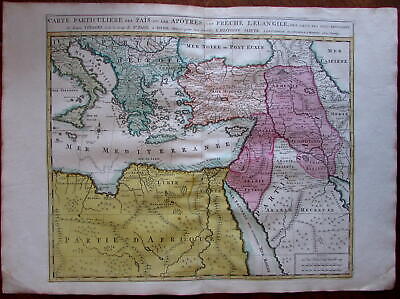
$11.85 Shipping Location: Dover, United States Carte Particuliere des Pais ou Les Apotres ont Preche l'Euan Gile; des Lieux les Plus Renommez de Leurs Voyages. Et de la Route de St. Paul a Rome. ... moreDressee pour bien entendre l'Histoire Sainte. Mediterranean. Arabia, Turkey, Greece, Armenia, North Africa) Issued Amsterdam. C. 1730-40 by Covens& Mortier. Fine mid-18th century engraved folio sheet map of the Mediterranean and Middle East. With original hand color. Quite interesting for the detailed depiction of Arabia. Armenia and Turkey during the time of the Apostles travels. In VG to near fine. Clean, well-preserved condition. A fine map. Sheet measures c. 24" W x 17" H. Printed area c. 18 1/4" W x 15" H. Folio. Tooleys Dictionary of Mapmakers. Vol. 1, p. 308. Marco van Egmond. Covens& Mortier. 3.3 R564. Everything we offer is guaranteed to be an authentic original antique item as described. We stand behind everything we sell. Important information for International Buyers* You may be charged customs. Taxes or other import duties by your country! this has nothing at all to do with us. Please do not hold us responsible if your Government wants to collect tax when you buy something outside of your country] Import duties. Taxes, and customs fees are not included in the item price or shipping cost. These charges are normally collected by the shipping service when the package is delivered or when you pick the item up. They are the buyer's responsibility and are not additional shipping charges. Please understand they have nothing to do with us and we have no control over them] Please check with your country's customs office to determine what these additional costs will be prior to bidding or buying. We do not know the various rules of your Customs office. There are a lot of countries in the world. Most with complex detailed variable laws in languages we don't read. Plus these laws are constantly being changed& revised] We won't under-value merchandise or mark the item as a gift on customs forms. Doing so is again
Buy It Now
$11.85 Shipping Location: Dover, United States Fine early 18th century engraved folio sheet map with extensive historical data at top right in key and across the bottom keyed to the map.
Buy It Now
$14.99 Shipping Location: Ivanhoe, Australia Very Good.
Buy It Now
$10.00 Shipping Location: Turkey Ottoman Map Dated 1325 (Hijri) Arabia, Red Sea, Africa, Abyssinia Region.
Buy It Now
$10.00 Shipping Location: Turkey Ottoman period. condition is quite high for age.
Buy It Now
$25.00 Shipping Location: Turkey Condition:see photo, 32 pages very rare item.
Buy It Now
Free Shipping Location: Monroe, United States MAP SHOWS ASIA AND THE MIDDLE EAST WITH PHYSICAL FEATURES INCLUDING MOUNTAIN RANGES, WATERWAYS, TABLE LANDS, HIGH AND LOW LANDS. MAP IS VERY DETAILED. ... morePUBLISHED BY WILLIAM C. WOODBRIDGE IN 1843. DATED 1843 AT BOTTOM LEFT.
Buy It Now
$4.95 Shipping Location: Dover, United States Tunison's Turkey in Asia, Persia, Arabia, Russian Turkestan, Afghanistan and Beloochistan. (Map, Arabia, Turkey, Persia, Arabian Sea, Afghanistan, Balochistan, ... morePersian Gulf ). Late 19th century lithographed map with strong original hand color.
Buy It Now
$4.99 Shipping Location: Fairview, United States , published in Chicago by the Rand, McNally Co., 1892, a facsimile copy of the title page is included for authenticity. Condition: The map is in Very ... moreGood to Excellent condition printed on a bright page, no centerfold, very clean and well preserved, see the pics for more on condition.
Buy It Now
$16.40 Shipping Location: Newtown, United States Johnson's Antique Map of Turkey Persia Arabia 1800s Colored. Shipped with USPS Priority Mail.
Buy It Now
$6.95 Shipping Location: Dover, United States There are many variant issues of this map, with differing borders and interior details. On the reverse is a map of "Persia, Arabia, Turkey in Asia, Afghanistan ... moreand Beloochistan". Issued 1873, Philadelphia by S. Augustus Mitchell.
Buy It Now
Free Shipping Location: Seattle, United States ORIGINAL ANTIQUE 1893 DOUBLE PAGE MAP OF ASIA. MAP HAS SCALE BELOW TITLE AT TOP LEFT. ORIGINAL 1893 ANTIQUE DOUBLE PAGE HAND-COLORED MAP OF ASIA. DATE ... more1893, NOT ON MAP.
Buy It Now
$10.00 Shipping Location: Cyprus Title: Turcici Imperii Deccriptio. His father was Pasquale Magini, a citizen of Padua. Origin: Geographiae universae tum veteris tum novae absolutissimum ... moreopus, duobus voluminibus distinctum. Antonio Magino Patavino Ptolemaeus, Claudius; Magini, Giovanni Antonio.
$16.00 Shipping Location: Poland Date of issue: 1865 (dated map). THIS IS AN ORIGINAL MAP, NOT A RECENT COPY OR REPRODUCTION. by Stulpnagel & Berghaus Hermann, engr. by Behrens, publ. ... moreby Perthes Justus, Gotha (Germany). HAND COLOURED.
Buy It Now
Free Shipping Location: Monroeville, United States Date - 1881. Condition - Quite Nice, left blank border has surface toning.
Buy It Now
$30.00 Shipping Location: Paris VI, France This encyclopedic work explains the history and the genealogy of the continents, with the geography, cosmography, topography, heraldry, and ethnography. ... moreThis map is based on Delisle's map of the region.
Buy It Now
Free Shipping Location: Monroeville, United States Date - 1869. inventory# j71296.
Buy It Now
$4.99 Shipping Location: Fairview, United States Stieler's Hand Atlas, published in Gotha by Justus Perthes. The publisher is stated in the bottom center, the title of the atlas is in the upper right ... morecorner and the printing details in the bottom left margin.
Buy It Now
$6.00 Shipping Location: North Wales, United States 1910 RARE ANTIQUE MCNALLY ATLAS MAP-ARABIA & TURKEY IN ASIA-EXCELLENT DETAIL ORIGINAL ANTIQUE ATLAS MAP PLEASE SEE PHOTOS AS PART OF THE DESCRIPTION CONDITION: ... moreMAP IS IN GOOD CONDITION. SIZE: APPROXIMATELY 11" X 14" SHIPPING: U.S. FIRST CLASS RATE - $6.00 - ANY ITEM WHICH SELLS FOR OVER $100 WILL REQUIRE INSURANCE WE COMBINE SHIPPING FOR MULTIPLE WINS. THANK YOU FOR YOUR INTEREST IN OUR AUCTIONS!.
$16.00 Shipping Location: Poland Date of issue: 1816. THIS IS AN ORIGINAL MAP, NOT A RECENT COPY OR REPRODUCTION. by Desray J., Paris (France). HAND COLORED.
Buy It Now
$6.80 Shipping Location: Santa Barbara, United States 1866 Johnson's Asia Rare Atlas Map, India, Arabia, Turkey, Siam, Persia, China This is a colorful map from Johnson's Atlas showing great detail of Asia. ... moreThe Empires of Asia are delineated. This is a colorful map from Johnson's Atlas showing great detail of Asia.
Buy It Now
$4.99 Shipping Location: Fairview, United States It is fromCollier's World Atlas and Gazetteer, New York, 1937, a copy of the title page is included for authenticity. Condition: It is in Very Good to ... moreExcellent condition for its age, very clean on strong flexible paper, a similar style map on reverse.
$16.00 Shipping Location: Poland Date of issue: ca 1750. THIS IS AN ORIGINAL MAP, NOT A RECENT COPY OR REPRODUCTION. Origin of the map: "The Modern Part of the Universal History.", engr. ... moreby Basire Isaac. by Richardson S. & Co, London (United Kingdom).
Buy It Now
$150.00 Shipping Location: Tidewater, United States It was manufactured by I. Cenex.
$14.00 Shipping Location: Poland Date of issue: 1750 (dated map). THIS IS AN ORIGINAL MAP, NOT A RECENT COPY OR REPRODUCTION. Origin of the map: "Méthode abregée et facile pour apprendre ... morela géographie.", publ. by Duchesne, Paris (France).
Buy It Now
$4.99 Shipping Location: Fairview, United States It is fromThe Geographical Annual published in Philadelphia by Carey, Lea & Blanchard, 1834, a facsimile copy of the title page is included for authenticity. ... moreIf you are looking for a beautiful map with strong color, they don't get much better than this.
Buy It Now
$9.20 Shipping Location: Eau Claire, United States THIS IS A NICE MAP OF TURKEY SAUDIA ARABIA IRAN FROM 1790. PRINTED IN FRANCE. LOTS OF DETAIL. TITLE PAGE NOT INCLUDED!
$15.00 Shipping Location: Poland Date of issue: 1862 (dated map). THIS IS AN ORIGINAL MAP, NOT A RECENT COPY OR REPRODUCTION. by Stulpnagel F., publ. by Perthes Justus, Gotha (Germany); ... moreHAND COLOURED.
Buy It Now
$4.99 Shipping Location: Fairview, United States Also included is a sheet of related text explaining the map. Overall, a very scarce map that is difficult to find. The pics are of the actual map, although ... morethe actual map look much better. An Authentic Antique Map: Not a Modern Reproduction!
Buy It Now
$6.95 Shipping Location: Dover, United States Issued 1848, Berlin by Flemming & Mahlmann. Map by von Wedell. Uncommon and interesting mid 19th century color lithographed historical map with original ... moreoutline hand color. Map is clean and in nice shape, but not new or in new condition.
Buy It Now
$6.95 Shipping Location: Dover, United States Map of Persia, Arabia, Turkey in Asia, Afghanistan, Beloochistan. Issued 1887, Philadelphia by Bradley, successor to S.A. Mitchell. This late Mitchell ... moremap was issued by Bradley for a short period before disappearing from publication.
|
|
|
|
Arabia Turkey Nubia Somalia Egypt Africa Red Sea Aden 1881 antique engraved map
Arabia Turkey Nubia Somalia Egypt Africa Red Sea Aden 1881 antique engraved map Turkey in Asia. Persia, Arabia, Egypt& Nile Countries Issued for Zell. 1881, Philadelphia by J. Bartholomew Fine original antique engraved map. Printed in the late 19th century on quality paper which retains its inherent structural flexibility and soundness. Engraved and printed in colors In VG or better condition. Some minor light spotting as well as light uniform age wear, but neither detract from the overall attractiveness of the image[note: we grade very conservatively and always seek to disclose any noteworthy flaws] The printed area remains visually pleasing. A nice impression of an interesting antique map. Any minor defects along the sheet edges and in the margins may be seen in the photos. Sheet measures c. 17 1/8" H x 12 3/8" W. Engraved ... morearea measures c. 16" H x 11 3/8" W. Original centerfold line as issued. 31467] note: All old sheets of printed paper possibly have short edge splits. Each sheet has existed for a very long time and has probably been handled repeatedly in the course of it's existence. It has a history unique to it as an object. Most of the time any edge splits are short. Minor, insignificant and have been closed- either long ago or more recently with small pieces of archival tape. Most often these splits are trivial and easy to overlook visually. Basically, they would not significantly affect the piece adversely. The item is offered as seen. Please look carefully and make your decision knowing this antique image is nice. But it is not in perfect"like new" condition. However, with whatever flaws it possesses, it remains entirely worthy of ownership and inclusion in any related collection. We feel it will prove very pleasing to its new owner. We stand behind everything we sell. Everything we offer is guaranteed to be an authentic original antique item as described. We do not sell modern reproductions. Please visit our eBay Store. We happily acce
|
|
|
Roman Empire Turkey Middle East Arabia 1787 Bonne antique folio engraved map
Roman Empire Turkey Middle East Arabia 1787 Bonne antique folio engraved map IMPERII ROMANI DISTRACTA(Eastern Roman Empire/ Middle East) Issued Paris. 1787 by M. Bonne. Engraved by Andre. Fine original antique engraved map. Made approximately 225 years ago. Printed in the late 18th century, on quality paper which retains its inherent structural flexibility and soundness. In near VG or better condition[note: we grade very conservatively and always seek to disclose any noteworthy flaws] The printed area remains visually pleasing. A nice impression of an interesting image. Sheet measures c. 11 1/2" W x 15 1/4" H. Engraved area measures c. 9" W x 13 1/2" H. Folio. Original fold line as issued. 10534] Any defects along the sheet edges and in the margins may be seen in the photos. note: All old sheets of printed paper possibly ... morehave short edge splits. Each sheet has existed for a very long time and has probably been handled repeatedly in the course of it's existence. It has a history unique to it as an object. Most of the time any edge splits are short. Minor, insignificant and have been closed- either long ago or more recently with small pieces of archival tape. Most often these splits are trivial and easy to overlook visually. Basically, they would not significantly affect the piece adversely. The item is offered as seen. Please look carefully and make your decision knowing this antique image is nice. But it is not in perfect"like new" condition. However, with whatever flaws it possesses, it remains entirely worthy of ownership and inclusion in any related collection. We feel it will prove very pleasing to its new owner. We stand behind everything we sell. Everything we offer is guaranteed to be an authentic original antique item as described. We do not sell modern reproductions. Please visit our. We happily accept PayPal! WE OFFER FLAT RATE SHIPPING WORLD WIDE! Please request an invoice before paying for mu
|
|
|
Arabia Turkey Persia Caboul 1831 Lapie beautiful antique engraved map
Arabia Turkey Persia Caboul 1831 Lapie beautiful antique engraved map Carte de la Turquie D'Asie. De la Perse, de l'Afghanistan et de L'Arabie(Turkey in Asia. Afghanistan and Arabia) Issued 1831. Paris by M. Lapie Fine original antique engraved map. Printed on quality paper which retains its inherent structural flexibility and soundness. With original outline hand color. In Good+ near VG or better condition. Light minor overall age dustiness and minor light damp staining to the upper corners[note: we grade very conservatively and always seek to disclose any noteworthy flaws] The printed area remains visually pleasing. A nice impression of an uncommon and beautiful engraved folio sheet map. Any minor defects along the sheet edges and in the margins may be seen in the photos. Sheet measures c. 24 1/4" W x 18 1/2" H. Engraved ... morearea measures c. 21 1/4" W x 15 5/8" H. Original fold line as issued. 31143] note: All old sheets of printed paper possibly have short edge splits. Each sheet has existed for a very long time and has probably been handled repeatedly in the course of it's existence. It has a history unique to it as an object. Most of the time any edge splits are short. Minor, insignificant and have been closed- either long ago or more recently with small pieces of archival tape. Most often these splits are trivial and easy to overlook visually. Basically, they would not significantly affect the piece adversely. The item is offered as seen. Please look carefully and make your decision knowing this antique image is nice. But it is not in perfect"like new" condition. However, with whatever flaws it possesses, it remains entirely worthy of ownership and inclusion in any related collection. We feel it will prove very pleasing to its new owner. We stand behind everything we sell. Everything we offer is guaranteed to be an authentic original antique item as described. We do not sell modern reproductions. Please visit our eBay Store. We happily accept P
|
|
|
Turkey Arabia Persia 1890 original antique color lithograph map
Turkey Arabia Persia 1890 original antique color lithograph map TURKEY in ASIA ARABIA. PERSIA, AFGHANISTAN& BALUCHISTAN issued Edinburgh. Scotland: 1890; by Bartholomew. Fine original antique color lithographed map. Printed on quality paper which retains its inherent structural flexibility and soundness. Map title printed on verso. In Very Good or better condition. Clean& well-preserved[note: we grade very conservatively and always seek to disclose any noteworthy flaws] Original center fold as issued. The printed area remains pleasing. A nice impression that would look great framed. Sheet measures c. 8 3/8" W x 7 1/8" H. Engraved area measures c. 7 7/8" W x 6 1/4" H. 36198] note: All old sheets of printed paper possibly have short edge splits. Each sheet has existed for a very long time and has probably been handled ... morerepeatedly in the course of it's existence. It has a history unique to it as an object. Most of the time any edge splits are short. Minor, insignificant and have been closed- either long ago or more recently with small pieces of archival tape. Most often these splits are trivial and easy to overlook visually. Basically, they would not significantly affect the piece adversely. The item is offered as seen. Please look carefully and make your decision knowing this antique image is nice. But it is not in perfect"like new" condition. However, with whatever flaws it possesses, it remains entirely worthy of ownership and inclusion in any related collection. We feel it will prove very pleasing to its new owner. We stand behind everything we sell. Everything we offer is guaranteed to be an authentic original antique item as described. We do not sell modern reproductions. Please visit our. We happily accept PayPal! WE OFFER FLAT RATE SHIPPING WORLD WIDE! Please request an invoice before paying for multiple items so that we can ensure that you are not overcharged for shipping! To receive our flat rate sh
|
|
|
1755 Postlethwayte Four Part Map of Turkey, Arabia, Persia, India and Tartary
1755 Postlethwayte Four Part Map of Turkey. Arabia, Persia, India and Tartary WE SELL ONLY ORIGINAL ANTIQUE MAPS- NOT REPRODUCTIONS Title: First Part of Asia. Being Turkey, Arabia, Persia, most of India and Tartary. Description: A curious and uncommon four panel wall map 1755 map of India. Persia, and Arabia by the English publisher M. Postlethwayte. Published in four separate panels, this map can be either joined as a single massive map as assembled, as above, in separate panels. As a whole the map centers on Persia, covering from Istanbul to eastern India and Tibet, and from the Black Sea to the Maldives. Postlethwayte derived this map from the influential French cartographer J. B. B. d'Anville's similar map of 1751, which here has been re-engraved, updated, and translated into English by S. Bolton. If offers excellent coverage ... moreof the central Asian portions of the Silk Route naming the centers of Samarkand, Bukhara, Lop Nor, and others. At the bottom center there is a decorative title cartouche of a rococo ethic. As this map was being edited, the eastern portions including Turkey, Arabia, and most of the modern day Middle East, were under the waning hegemony of the Ottoman Empire. In Arabia, the first'Saudi State' had already been established in 1744 and, though owing nominal allegiance to Istanbul, dominated much of the central Arabian Peninsula. The presumably more valuable costal lands and river valleys of Mesopotamia(modern day Iraq) remained under direct Ottoman suzerainty. Persia at this time was itself experiencing the early years of the short lived Zand Dyansty who ruled from the capital city of Isfahan– identified here. The Zand ruled Persia for roughly 50 years until, in 1794, Aga Muhammad Khan overthrew Loft Ali Khan, last Shah of the Zand Dynasty, and relocated the capital to the new city of Terhan. The subsequent era, the Qajar Dynasty, witnessed numerous military conflicts, the rising powers of Imperial Russia, and the loss of much of Persia's territory. India meanwhile was qui
|
|
|
Egypt Middle East Turkey Arabia Red Sea 1896 Stieler antique engraved color map
Egypt Middle East Turkey Arabia Red Sea 1896 Stieler antique engraved color map Untitled(North Africa/ Palestine/ Middle East) Issued 1896. Gotha Germany by Perthes for Stieler Fine antique engraved map. With original outline hand color. Made approximately 115 years ago. Printed in the late 19th century, on quality paper which retains its inherent structural flexibility and soundness. A beautifully engraved and very detailed map of this region. With a profusion of details not often seen. With Colonial political boundaries which no longer exist, and several detailed insets, each labelled with precision. In near VG or better condition. Some light scattered foxing as typical[note: we grade very conservatively and always seek to disclose any noteworthy flaws] The printed area remains visually pleasing, a nice impression of an interesting map. ... moreSheet measures c. 18 3/4" W x 15" H. Engraved area measures c. 15 3/4" W x 13" H. 10910] Any defects along the sheet edges and in the margins may be seen in the photos. note: All old sheets of printed paper possibly have short edge splits. Each sheet has existed for a very long time and has probably been handled repeatedly in the course of it's existence. It has a history unique to it as an object. Most of the time any edge splits are short. Minor, insignificant and have been closed- either long ago or more recently with small pieces of archival tape. Most often these splits are trivial and easy to overlook visually. Basically, they would not significantly affect the piece adversely. The item is offered as seen. Please look carefully and make your decision knowing this antique image is nice. But it is not in perfect"like new" condition. However, with whatever flaws it possesses, it remains entirely worthy of ownership and inclusion in any related collection. We feel it will prove very pleasing to its new owner. We stand behind everything we sell. Everything we offer is guaranteed to be an authentic original antique item as described. We do not s
|
|
|
Arabia Middle East Persia Turkey Armenia 1867 Johnson color antique map folio
Arabia Middle East Persia Turkey Armenia 1867 Johnson color antique map folio JOHNSON'S TURKEY IN ASIA/ JOHNSON'S PERSIA, ARABIA, BELOOCHISTAN AND AFGHANISTAN(2 maps on 1 sheet) Issued New York. 1867 by Johnson. Attractive mid 19th century folio lithographed map. With original hand color. Wonderfully detailed. In good+. Mostly clean condition. Some light toning and spotting- mainly to margins and hardly offensive- as well as a few short edge splits which have been cleanly mended with archival tape. Otherwise map remains clean and quite well-preserved. Will look great displayed. Sheet measures c. 18" W x 26 1/4" H. Printed area measures c. 15 1/4" W x 22" H. Folio. Original fold line as issued. 5954] Any defects along the sheet edges and in the margins may be seen in the photos. note: All old sheets of printed paper ... morepossibly have short edge splits. Each sheet has existed for a very long time and has probably been handled repeatedly in the course of it's existence. It has a history unique to it as an object. Most of the time any edge splits are short. Minor, insignificant and have been closed- either long ago or more recently with small pieces of archival tape. Most often these splits are trivial and easy to overlook visually. Basically, they would not significantly affect the piece adversely. The item is offered as seen. Please look carefully and make your decision knowing this antique image is nice. But it is not in perfect"like new" condition. However, with whatever flaws it possesses, it remains entirely worthy of ownership and inclusion in any related collection. We feel it will prove very pleasing to its new owner. We stand behind everything we sell. Everything we offer is guaranteed to be an authentic original antique item as described. We do not sell modern reproductions. Please visit our. We happily accept PayPal! WE OFFER FLAT RATE SHIPPING WORLD WIDE! Please request an invoice before paying fo
|
|
|
Turkey Persia Arabia 1891 Tunison antique lithographed hand color map
Turkey Persia Arabia 1891 Tunison antique lithographed hand color map Tunison's Turkey in Asia. Persia, Arabia, Russian Turkestan, Afghanistan and Beloochistan Issued 1891. Chicago, Tunison Fine original lithographed antique map. Printed in the late-19th century, on quality paper which retains its inherent structural flexibility and soundness. With original hand color. In VG or better condition. Light minor age wear, overall very presentable and attractive[note: we grade very conservatively and always seek to disclose any noteworthy flaws] The printed area remains visually pleasing. A nice impression of an interesting antique map which will look nice when displayed. Sheet measures c. 13 7/8" W x 11 1/4" H. Printed area measures c. 12" W x 9 3/4" H. 19047] Any defects along the sheet edges and in the margins may be ... moreseen in the photos. note: All old sheets of printed paper possibly have short edge splits. Each sheet has existed for a very long time and has probably been handled repeatedly in the course of it's existence. It has a history unique to it as an object. Most of the time any edge splits are short. Minor, insignificant and have been closed- either long ago or more recently with small pieces of archival tape. Most often these splits are trivial and easy to overlook visually. Basically, they would not significantly affect the piece adversely. The item is offered as seen. Please look carefully and make your decision knowing this antique image is nice. But it is not in perfect"like new" condition. However, with whatever flaws it possesses, it remains entirely worthy of ownership and inclusion in any related collection. We feel it will prove very pleasing to its new owner. We stand behind everything we sell. Everything we offer is guaranteed to be an authentic original antique item as described. We do not sell modern reproductions. Please visit our. We happily accept PayPal! WE OFFER FLAT RATE SHIPPING W
|
|
|
Middle East Iran Turkey Arabia Cyprus Parthian Empire c.1780 Bonne antique map
Middle East Iran Turkey Arabia Cyprus Parthian Empire c.1780 Bonne antique map Imperii PArthorum Tabula Pars Occidentalis(Parthian Empire) Issued 1780. Paris by R. Bonne Fine original antique engraved map. Printed in the late 18th century, on quality hand-made paper which retains its inherent structural flexibility and soundness. An uncommon version of this Bonne map. With the date printed below the title. With original outline hand color. In near VG or better condition. Light minor age wear, light toning to sheet, but overall very presentable and attractive[note: we grade very conservatively and always seek to disclose any noteworthy flaws] The printed area remains visually pleasing. A nice impression of an interesting antique map which will look nice when displayed. Sheet measures c. 11 1/4" W x 16" H. Printed area measures c. ... more9 1/4" W x 13 1/2" H. Original fold line as issued. 27568] Any defects along the sheet edges and in the margins may be seen in the photos. note: All old sheets of printed paper possibly have short edge splits. Each sheet has existed for a very long time and has probably been handled repeatedly in the course of it's existence. It has a history unique to it as an object. Most of the time any edge splits are short. Minor, insignificant and have been closed- either long ago or more recently with small pieces of archival tape. Most often these splits are trivial and easy to overlook visually. Basically, they would not significantly affect the piece adversely. The item is offered as seen. Please look carefully and make your decision knowing this antique image is nice. But it is not in perfect"like new" condition. However, with whatever flaws it possesses, it remains entirely worthy of ownership and inclusion in any related collection. We feel it will prove very pleasing to its new owner. We stand behind everything we sell. Everything we offer is guaranteed to be an authentic original antique item as described. We do not sell modern reproductions. Please visit o
|
|
|
Central Asia Persia Arabia Turkey in Asia Egypt c.1880 antique wood engraved map
Central Asia Persia Arabia Turkey in Asia Egypt c.1880 antique wood engraved map Map of Central Asia. Persia, Arabia, and Turkey in Asia Issued c.1880. London Fine original antique wood engraving printed in the late-19th century. On quality paper which retains its inherent structural flexibility and soundness. In near VG or better condition. Light minor toning to sheet as typical, remaining clean and attractive[note: we grade very conservatively and always seek to disclose any noteworthy flaws] Text on verso as issued. The printed area remains visually pleasing. A fine impression of an interesting antique image which will look nice when displayed. Sheet measures c. 7 1/4" H x 10 1/4" W. Printed area measures c. 5 1/8" H x 7 3/4" W. 34351] Any defects along the sheet edges and in the margins may be seen in the photos. note: ... moreAll old sheets of printed paper possibly have short edge splits. Each sheet has existed for a very long time and has probably been handled repeatedly in the course of it's existence. It has a history unique to it as an object. Most of the time any edge splits are short. Minor, insignificant and have been closed- either long ago or more recently with small pieces of archival tape. Most often these splits are trivial and easy to overlook visually. Basically, they would not significantly affect the piece adversely. The item is offered as seen. Please look carefully and make your decision knowing this antique image is nice. But it is not in perfect"like new" condition. However, with whatever flaws it possesses, it remains entirely worthy of ownership and inclusion in any related collection. We feel it will prove very pleasing to its new owner. We stand behind everything we sell. Everything we offer is guaranteed to be an authentic original antique item as described. We do not sell modern reproductions. Please visit our. We happily accept PayPal! WE OFFER FLAT RATE SHIPPING WORLD WIDE! Please
|
|
|
1812 Malte-Brun Map of Turkey in Europe, Arabia, Persia, Central Asia
1812 Malte-Brun Map- Asie Occidentale Conrad Malte-Brun's Atlas Complet du Precis de la Geographie Universelle. From which this map comes, was published in Paris in 1812 and was one of the best and most up-to-date atlases of the early-19th century. It used charming vignette scenes in the title, a practice to be copied by other French mapmakers and the John Tallis company in England. Malte-Brun, a Danish geographer and publisher who settled in Paris, used French engineer and geographer Alexandre Lapie, as well as engravers Jean-Baptiste Tardieu and Jean-Baptiste Chamouin, in the creation of his atlas. This map has excellent detail and clear engraving. The map includes Turkey in Asia. The Kingdom of Persia, Arabia, Afghanistan, Independant Tartary, the Russian Empire. The map has a scale of distance, and a charming title vignette of a camel. ... moreThe map measures 11.5" by 8" Has later outline hand colouring, and is in good condition except that there is a fair amount of foxing of the page. The map is guaranteed to be over 210 years old. Shipping United States- Regular airmail $5.00US. Registered/insured airmail with tracking(optional) is an additional US$15.00 for a total of US$20.00. Canada- $3.00US for regular mail. $9.00US for registered mail. Canadian customers please add GST or HST as applicable. Sorry, we cannot arrange for pick up of ebay items. Rest of the world- Regular air mail $8.00US. Registered/insured airmail with tracking(optional) is is an additional US$15.00 for a total of US$23.00. Terms and Conditions Please note- We can only take responsibility for delivery if the optional registration/insurance is added. Regular airmail is usually very safe and reliable. But items sent by regular airmail are at the buyers risk- regular airmail provides no tracking number, no proof of shipping or delivery, and no insurance in case of loss or damage. Please note- Mailing from Canada to the United States and all other international destinations can sometimes take over three weeks for delivery. We will com
|
|
|
1812 - LAPIE - Map TURKEY ARABIA PERSIA AFGHANISTAN TARTARY
You are bidding on an ORIGINAL 19th century map* Asie occidentale- Lapie. Capitaine Ingénieur Géographe- Chamouin Atlas complet du précis de la géographie universelle de M. Malte-Brun. Paris. Buisson 1812 Other maps from this book are offered for sale Steelplate engraving printed on one side only Paper Strong and heavy Color Hand coloring Inches 8 1/2 x 11 3/4. Cm 21.5 x 29.7. Plus margins Excellent. Light soiling to margins. Dark impression. Priority airmail. USA. Americas $6.00(approx. 14/21 days) 2 or more similar maps $10.00. European Union $4.50(approx. 5/7 days) 2 or more similar maps $8.50. Optional registration $6.00. I will combine shipping for multiple purchases 2p5ddv.RcmdId ViewItemDescV4,RlogId p4%60bo7%60jtb9%3Fuk%601d72f%2B26rk%3E2p5ddv-13e90c05498-0xf7-
|
|
|
Saudi Arabia Iran Plateau Turkey Abyssinia 1876 antique color lithograph map
Vorder-Asien(Middle East/Western Asia) Issued 1876. Germany by George Westermann Fine original antique color lithograph map. Printed on quality paper which retains its inherent structural flexibility and soundness. In near VG or better condition. Some light minor age wear but the image remain clean and very attractive[note: we grade very conservatively and always seek to disclose any noteworthy flaws] The printed area remains visually pleasing. A nice impression of an interesting antique map. Any minor defects along the sheet edges and in the margins may be seen in the photos. Sheet measures c. 11 1/4" W x 13" H. Engraved area measures c. 9 1/2" W x 10 3/8" H. With original fold line as issued. 40201] Guaranteed Authentic! We do not sell modern reproductions. Condition All of our items are original antique pieces and it ... moreis important to keep in mind that many of them have been around for 100 years or more. Individual pieces may have seen many owners and been handled many times over the course of their existence and as a result each piece has developed a history of it's own. Short edge splits(often repaired with archival tape) Foxing, discoloration, etc. are all things to expect on items of this type. They rarely distract from the piece and often add to the overall character of the item. Keep in mind when you receive your item that you are not handling a modern copy, you are holding a piece of history, an item that has been around for a very long time and will, with proper care, be around for a long time to come. We try to note any significant flaws in the description, but less noticeable or common characteristics may not be mentioned. As we are a US based company all of our measurements are in Inches. If you need the size in Centimeters please multiply the supplied measurement by 2.53. Payment and Shipping We happily accept PayPal! Payment is appreciated within 5 days of invoicing. Once payment has been received we do our best to make sure all orders are shipped within two business days and
|
|
|
GREECE TURKEY ARMENIA CYPRUS ARABIA OLD MAP DE L'ISLE. 1723
. GREECE TURKEY ARMENIA CYPRUS ARABIA OLD MAP DE L'ISLE. 1723 Title: RETRAITE DES DIX MILLE Tabula conspectum exhibens Regionum omnium quas Cyrus Junior. Artaxerxi fratibellum illaturus ac Cyro in acie caeso, auxiliares Graeci peragranunt, ad mentem Xenophontis consecta, at que hodiernis locorum nominibus illustrata. In usum studiorm Christianissimi Francorum Regis elaborata; a Guillelmo Delisle Primario Suae Majestatis Christianissimae Geographo, ac Regiae Scientiarum Academiae socio. Parisiis, apud Auctorem in Ripa vulgo dicta le Quay de l'Horloge, I. Oct. M.DCCXXIII. Published by: DE L'ISLE. William Delisle(French: Guillaume Delisle' February 28. 1675- January 25 de 1726) was a French cartographer who lived in Paris. His father. Claude Delisle(1644-1720) studied law and then moved to Paris where he lived by giving private ... morelessons on geography and history, later obtained by Censor Real. He was also a cartographer. Had 11 children among which were William and Joseph-Nicolas Delisle William's early works were"World Map" and"Map of the Continents" Both published in 1700. Work together with the subsequent land maps outperformed similar publications, which gave him fame. In 1702 he became a student in 1716 and in 1718 deputy member of the Academy of Sciences, also was a professor of geography of the young King Louis XV, receiving the title of Geographer Royal, which included a salary, a title that was opened to him. ORIGINAL ANTIQUE COPPER PLATE ENGRAVING With fine hand coloring. Engraving is Guaranteed authentic. A Certificate of Authenticity will be on request forwarded for each individual map or print. Size: Sheet app. 71 x 54 cm. 28 x 21.5 inches. Image app; 57 x 44 cm. 22.5 x 17.25 inches. Condition: View overall very good. Tired huge borders. Fold as published. Verso blanco. . All maps and prints are genuine. Authentic, published at the date stated in this listing! For better quality pictures please go to our web site: WWW.MAPANDMAPS.COM I offer a no questions r
|
|
|
Johnson's Family Atlas TURKEY IRAN IRAQ ARABIA AFGHANISTAN handcolored MAP 1864
Genuine hand-colored MAP Johnson's Family Atlas 1864 Turkey in Asia. Persia, Arabia Sheet dimensions: 18 x 14.5 inches Good condition. Overall clean. Scattered minor spot or two, but overall a very presentable and attractive map Maps mailed in cardboard tubes Combined shipping at no additional charge Powered by The free listing tool. List your items fast and easy and manage your active items.
|
|
|
MIDDLE EAST ANTIQUE MAP, PERSIA, ARABIA, TURKEY, BY PHILIPPE DE PRETOT 1787
. MIDDLE EAST ANTIQUE MAP. PERSIA, ARABIA, TURKEY, BY PHILIPPE DE PRETOT 1787 Title: Chorographie des deux anciennes Monarchies universelles. La lre. Des Babylon et des Assyriens: la 2me celle des Médes et des Perses. From: World atlas for the study of geography and ancient and modern history. Paris, 1787. Philippe de Pretot. Etienne André(1708-1787) ORIGINAL ANTIQUE COPPER PLATE ENGRAVED MAP Full hand colored. Map is Guaranteed authentic. A Certificate of Authenticity will be on request forwarded for each individual map or print. Image app. 41 x 26.5 cm. 16.25 x 10.5 inches. Condition: View very good. Fold as published, low to nil borders, written ink numbered. All maps and prints are genuine. Authentic, published at the date stated in this listing! For better quality pictures please go to our web site: WWW.MAPANDMAPS.COM ... more I offer a no questions returns policy. All maps and prints are genuine. Authentic, published at the date stated above. Worldwide shipping by signed registered mail or Global Express courier. Shipping fee is per combined shipment. Including handling and insurance. Free shipping worldwide if three items or more purchased. . .
|
|
|
Turkey in Asia Persia Arabia Turkestan c.1868 antique engraved color map
Turkey in Asia. Persia, Arabia, Afghanistan, Beloochistan and Turkestan Issued c.1868. Philadelphia by S. Augustus Mitchell Fine original antique engraved map. With original hand color. Map of India. China& Southeast Asia on back. Printed on quality paper which retains its inherent structural flexibility and soundness. In VG or better condition. Mostly clean and attractive, minor light surface age wear as typical, the map remains very presentable and well worthy of ownership[note: we grade very conservatively and always seek to disclose any noteworthy flaws] The printed area remains visually pleasing. A nice impression of an interesting antique map. Any minor defects along the sheet edges and in the margins may be seen in the photos. Sheet measures c. 11 5/8" W x 9" H. Engraved area measures c. 10 5/8" W x 8 1/8" H. ... more44048] Guaranteed Authentic! We do not sell modern reproductions. Condition All of our items are original antique pieces and it is important to keep in mind that many of them have been around for 100 years or more. Individual pieces may have seen many owners and been handled many times over the course of their existence and as a result each piece has developed a history of it's own. Short edge splits(often repaired with archival tape) Foxing, discoloration, etc. are all things to expect on items of this type. They rarely distract from the piece and often add to the overall character of the item. Keep in mind when you receive your item that you are not handling a modern copy, you are holding a piece of history, an item that has been around for a very long time and will, with proper care, be around for a long time to come. We try to note any significant flaws in the description, but less noticeable or common characteristics may not be mentioned. As we are a US based company all of our measurements are in Inches. If you need the size in Centimeters please multiply the supplied measurement by 2.53. Payment and Shipping We happily accept PayPal! Payment is appreciated within 5 d
|
|
|
Egypt Arabia Turkey Cyprus Balkans antique 1890 engraved detailed color map
Nord-Ost Afrika(North East Africa. Egypt, Arabia, Turkey, Greece& Balkans) Issued 1890. Gotha Germany for Stieler. Fine original antique engraved map with original hand color. Printed on quality heavy paper which retains its inherent structural flexibility and soundness. In near VG or better condition. Mostly clean and attractive, minor light surface age wear, pleasing and very detailed map well worthy of display[note: we grade very conservatively and always seek to disclose any noteworthy flaws] The printed area remains visually pleasing. A nice impression of an interesting antique map. Any minor defects along the sheet edges and in the margins may be seen in the photos. Sheet measures c. 18 3/4" W x 15 3/8" H. Engraved area measures c. 16" W x 13 1/8" H. Original centerfold as issued. 44364] Guaranteed Authentic! ... moreWe do not sell modern reproductions. Condition All of our items are original antique pieces and it is important to keep in mind that many of them have been around for 100 years or more. Individual pieces may have seen many owners and been handled many times over the course of their existence and as a result each piece has developed a history of it's own. Short edge splits(often repaired with archival tape) Foxing, discoloration, etc. are all things to expect on items of this type. They rarely distract from the piece and often add to the overall character of the item. Keep in mind when you receive your item that you are not handling a modern copy, you are holding a piece of history, an item that has been around for a very long time and will, with proper care, be around for a long time to come. We try to note any significant flaws in the description, but less noticeable or common characteristics may not be mentioned. As we are a US based company all of our measurements are in Inches. If you need the size in Centimeters please multiply the supplied measurement by 2.53. Payment and Shipping We happily accept PayPal! Payment is appreciated within 5 days of invoicing. Once payment
|
|
|
1880 map: TURKEY, PERSIA, ARABIA, EGYPT & the NILE lands, IRAN; John Batholomew
Bartholomew map. 1880: TURKEY in ASIA PERSIA. ARABIA, EGYPT& NILE COUNTRIES This is a detailed antique map of a large swath of the Middle East and Northern Africa. It is printed nicely in color and goes from Constantinople in the upper left corner. To the Gulf of Oman on the right border, to Lake Ukerewe or Victoria N'Yanza at the bottom of the map. The map measures 12.5 x 17 inches. And is blank on the back. It is in Fine condition. The credit lines in small print below the map say: Engraved& Printed in Colours— by J. Bartholomew T. Ellwood Zell. Davis& Co. Philadelphia. The map is undated on the plate. But came from an uncommon atlas published in Philadelphia in 1880, which was Volume 5 of Zell’s Popular Encyclopedia. The mapmaker. John Bartholomew was a Fellow of the Royal Geographical Society. The map will be accompanied ... moreby a 5-page index presenting a key to the many features shown on the map: over 100 divisions or provinces; more than 700 towns; and more than 80 rivers; plus numerous lakes. Mountains, plains, bays and isles, etc. The map will be shipped folded once. As originally published in Zell’s Atlas. SHIPPING/ HANDLING TERMS: Add a flat $ 3.95 for delivery by First Class Mail anywhere in the U.S. Pennsylvania residents. Add 6% tax. International shipping is $ 8.95 to Canada; or $13.95 to all other foreign countries. I normally mail items within 24 hours of receiving payment. All items are returnable for a full refund if the buyer is unsatisfied for any reason. gsrx_vers_476(GS 6.4.4(476)
|
|
|
Turkey in Asia Persia Arabia Afghanistan 1893 antique lithograph hand color map
Turkey in Asia. Persia, Arabia, Russian Turkestan, Afghanistan& Beloochistan Issued 1893. Jacksonville, Illinois by Tunison Fine original antique lithographed map. With original hand color and a lovely decorative border. Printed on quality paper which retains its inherent structural flexibility and soundness. In near VG or better condition. Minor light surface age wear, but the image remains clean and very attractive[note: we grade very conservatively and always seek to disclose any noteworthy flaws] The printed area remains visually pleasing. A nice impression of an interesting antique map. Any minor defects along the sheet edges and in the margins may be seen in the photos. Sheet measures c. 11 3/8" H x 13 5/8" W. Engraved area measures c. 9 3/4" H x 12 1/2" W. 46234] Guaranteed Authentic! We do not sell modern reprints. ... moreCondition All of our items are original antique pieces and it is important to keep in mind that many of them have been around for 100 years or more. Individual pieces may have seen many owners and been handled many times over the course of their existence and as a result each piece has developed a history of it's own. Short edge splits(often repaired with archival tape) Foxing, discoloration, etc. are all things to expect on items of this type. They rarely distract from the piece and often add to the overall character of the item. Keep in mind when you receive your item that you are not handling a modern copy, you are holding a piece of history, an item that has been around for a very long time and will, with proper care, be around for a long time to come. We try to note any significant flaws in the description, but less noticeable or common characteristics may not be mentioned. As we are a US based company all of our measurements are in Inches. If you need the size in Centimeters please multiply the supplied measurement by 2.53. Payment and Shipping We happily accept PayPal! Payment is appreciated within 5 days of invoicing. Once payment has been received we do our
|
|
|
1897 MAP OF PART OF TURKEY IN ASIA, ARABIA, OMAN & ADEN * Century Co.
Auction Wizard 2000 Listing Template- AW2KLOT#7533 Please note that Customs delays for international shipping have been SIGNIFICANT lately- days or even weeks longer than they should be! Please take this into consideration Our goal is 5 star service! If you feel we have not lived up to a 5 star rating. Please contact us as we only want 100% satisfied customers and NO misunderstandings! Description below pictures* 1897 MAP OF PART OF TURKEY IN ASIA. ARABIA, OMAN& ADEN* Century Co. $34.95 An Original Vintage Antique Map: Not a Reproduction! See Our Ebay Store for other Antique Maps! Free US Shipping on Purchases of $100 value or more of Maps and Prints MAP OF PART OF TURKEY IN ASIA. ARABIA, OMAN& ADEN with insets of Modern Palestine& Modern Jerusalem Description: This is an authentic antique map approximatley 116 years old! Map ... moreMaker/Publisher: The Century Co. 1897.Colored lithographic engraving. Blank on reverse except for titling. Doublepage map with fold at center. The map is not mounted. Matted or framed and is being sold as a single sheet as shown in the first picture. Would Frame up Nicely! Size: Map measures approximately 16 1/2" x 11 3/4" 41.9 x 29.8 cm) including margins as seen in the pictures. Condition: This map is in Very good to Fine condition. It is clean and still has strong presence. Singlepage map as seen in the pictures. Very light wear. It is basically as seen in the pics. Very clean and would frame up nicely. See pictures for more on condition. The pictures shown are of the actual print being sold. Shipping: Please use the calculator under the"Shipping and payments" tab above to determine shipping for your location. All packages are sent with Delivery confirmation where possible. We always combine shipping. So on multiple items please wait until we send you an invoice with the correct shipping applied. Maps and Prints will be shipped either flat or rolled depending on the items being shipped. We use only sturdy shipping materials to make sure the package arrives
|
|
|
1897 MAP OF TURKEY IN ASIA ARABIA OMAN ADEN Century Co. Color Litho Engraving
1897 MAP OF TURKEY IN ASIA ARABIA OMAN ADEN Century Co. Color Litho Engraving Click Images to Enlarge Details Full Title: 1897 MAP OF PART OF TURKEY IN ASIA ARABIA OMAN AND ADEN Year: 1897 Publisher/Printer: The Century Co. Engraving style: Colored Lithograph Condition Grade: Collectible. Very Good+/Fine Authentication: Appraisal Valuation Sheet available Appraised Value: $70 Approximate Size(inches) 16 1/2" x 11 3/4" Approximate Size(Cm) 41.9 x 29.8 Description This is an authentic antique map approximatley 116 years old! Map Maker/Publisher: The Century Co. 1897. Colored lithographic engraving. Blank on reverse except for titling. Doublepage map with fold at center. The map is not mounted, matted or framed and is being sold as a single sheet as shown in the first picture. This map is in Very good to Fine condition. It is clean ... moreand still has strong presence. Very light wear. It is basically as seen in the pics. Very clean and would frame up nicely, see pictures for more on condition. The pictures shown are of the actual map being sold. Keywords: Colored Engraved. Turkey, Asia, Arabia, Oman, Aden, Mercator, 1800s, Litho, Lithograph, Color Engraving, Atlas Map CUSTOMER SERVICE& PRICING Our pricing directly reflects the time and careful consideration invested in acquiring and researching the finest quality products for you. The discriminating consumer. We recognize that all of our customers have their own specific needs and wants and we strive to meet these needs whether you are an Historical Institution, University, Library, Society, Archivist, Curator, Decorator, Designer, or Collector. We have structured our business to accommodate these requirements. We sell to a select group of customers from beginning collectors to advanced, seasoned collectors and everyone in between. Our many years of positive feedback from the thousands of loyal customers most often reflects the Quality of our items, Fine packaging, and Great Customer Service. Below are some of the finer points of what sets us apart as a worl
|
|
|
Turkey in Asia Persia Arabia c.1840 antique engraved map
Turquie d'Asie. Perse et Arabie(Turkey in Asia. Persia& Arabia) Issued c.1840-45. Paris by Monin& Fremin Engraved by Benard Fine original antique engraved map. With original outline hand color. Printed on quality paper which retains its inherent structural flexibility and soundness. In near VG to VG or better condition. Mostly clean and attractive, minor light surface age wear and some trivial minor dustiness but the image remains presentable and well worthy of ownership[note: we grade very conservatively and always seek to disclose any noteworthy flaws] The printed area remains visually pleasing. A nice impression of an interesting antique map. Any minor defects along the sheet edges and in the margins may be seen in the photos. Sheet measures c. 12" W x 9 1/4" H. Engraved area measures c. 9 3/4" W x 7 1/2" ... moreH. 45301] Guaranteed Authentic! We do not sell modern reprints. Condition All of our items are original antique pieces and it is important to keep in mind that many of them have been around for 100 years or more. Individual pieces may have seen many owners and been handled many times over the course of their existence and as a result each piece has developed a history of it's own. Short edge splits(often repaired with archival tape) Foxing, discoloration, etc. are all things to expect on items of this type. They rarely distract from the piece and often add to the overall character of the item. Keep in mind when you receive your item that you are not handling a modern copy, you are holding a piece of history, an item that has been around for a very long time and will, with proper care, be around for a long time to come. We try to note any significant flaws in the description, but less noticeable or common characteristics may not be mentioned. As we are a US based company all of our measurements are in Inches. If you need the size in Centimeters please multiply the supplied measurement by 2.53. Payment and Shipping We happily accept PayPal! Payment is appreciated within 5 day
|
|
|
MACEDONIAN KINGDOM GREECE TURKEY IRAN INDIA ARABIA 1757 DE VAUGONDY ANTIQUE MAP
Title: ANTIQUOR? IMPERIORUM TABULA in qua prae cateris. MACEDONICUM seu ALEXANDRI MAGNI. Author: Gilles Robert de Vaugondy(1688–1766) Source: Atlas Universel' Date: Edited from 1757 to 1768. Paris. Technique: Copper engraving. Sheet size: 77x56 cm. Engraving Size: 63.5x50 cm. Condition: Dark impression on paper with chains and wiremarks. Original border's watercoloring. Worn borders with tears(upper and lower) 4 damp patches on left.Right and upper margins. Foxings on blank margins. Faded ink. Few professionally restored tiny holes on central fold and few others on lower margin. Good conditions. Conditions are as you can see in the images. All of the engravings and books I sell are original. I guarantee all of my engravings to be authentic. Please examine the images provided carefully. And if you have any questions, please ask and ... moreI will be happy to help. Any item purchased from me may be returned for any reason for a full refund. Bank transfer is accepted! If you buy more than one item. You have to pay only one shipping cost.
|
|
|
1863 Johnson Map of Arabia, Persia, Turkey and Afghanistan (w/ Iran and Iraq)
1863 Johnson Map of Arabia. Persia, Turkey and Afghanistan(w/ Iran and Iraq) WE SELL ONLY ORIGINAL ANTIQUE MAPS- NOT REPRODUCTIONS Title: Johnson's Turkey in Asia Persia Arabia etc. Description: This is a very nice example of Johnson and Ward's 1863 map of Arabia. Persia and Turkey in Asia. It covers from the Mediterranean and Egypt eastwards as far as the Mouths of the Indus River, as well as southward as far as the Horn of Africa and northwards to the Black Sea. Depicts most of the politically volatile modern day middle east, including the nations of Afghanistan, Iraq, Iran, Saudi Arabia, Jordan, Israel, Syria, Lebanon and Turkey. Offers color coding according to country and region as well as notations regarding desert caravan routes, oases, roadways, river systems, forts and monasteries, and some topographical features. Ostensibly ... morethis map is very similar to Colton's 1858 map of the same region; however, there are a number of significant differences. Johnson reduced Colton's original map in order to expand the map westward by about 10 degrees, making it possible for him to incorporate all of Turkey as well as add significant detail in northwestern Africa and the Nile Valley. Johnson's retooling of the map also allowed for the addition of his three attractive woodcut views: Muscat(lower left) Trebisond(lower left) and the Castle and Port of Smyrna(lower right) The map features the fretwork style border common to Johnson's atlas work from 1863 to 1869. Published by Johnson and Ward as plate no. 89 in the scarce 1863 edition of Johnson's Family Atlas. Size: Printed area measures 13 inches high by 17 inches wide. Condition: Very good. Text on verso. Overall age toning. Minor spotting. Shipping: Due to recent increases in United States Postal Service rates we have been forced to increase our shipping rates. Shipping rates are not negotiable. Items are shipped within three business days of receiving payment. We are happy to consolidate shipping where possible. The following shipping optio
|
|
|
1871 map of Turkey in Asia, Persia, Arabia & Egypt. Engraved, Detailed. Genuine.
This is an 1871 engraved map of Turkey in Asia. Persia, Arabia, Egypt and the Nile Countries. It measures 12.5 X 17 inches. Has nice circular inset of Paris. Published by T. Edward Zell. Philadelphia. Map was engraved by J. Bartholomew. For history of the famous Bartholomew maps, see last paragraph below. We are unable to find many of these maps in the major dealers sites. The ones we did find had prices of $200- $500 and up and were not in as good a condition as this map. Be my guest. Go look for yourself. Paper shows minor age spots. Normal on most maps this age due to paper content. We have shown in the scans of the map and close ups to get a great idea of the beauty of the gentle coloring and detailed engraving. One of the scans above shows the copyright data found for Zell's publications. Zell originally acquired these maps for his ... morepublications. And re-issued the same maps in all additional updates. Each map has the publisher in the middle of the lower margin and the engraver of the map in the lower right margin, see scans above. Would look fantastic framed under glass. Imagine this map displayed in a professionals waiting room or anywhere for that matter. Any shadows or blurry edges are my scanner. Not the map. These maps are quite dear. Fantastic to behold, and a very smart investment opportunity especially when buying at our low wholesale prices. Click here to read our new help guide. This article is applicable to all vintage maps. Not just railroad maps. Owning one of these classic early J. Bartholomew maps is a delight and sign of rare tastes. If you like this map. We strongly advise you buy it now. It is highly doubtful we will ever find another in this nice a condition. Once sold it is gone, and the opportunity for you to own it no longer exists. We will ship this map carefully rolled in kraft paper inside a pvc tube to prevent any damage in transit. It is also insured by us at no additional cost to you. History: The cartographic story of the Bartholomew family begins with George Bartholomew(Janua
|
|
|
Antique Atlas Map 1867 Johnson's Lithograph Print Turkey Asia Persia Arabia Maps
Item Specifics: Antique Atlas Map 1867 Johnson's Print Lithograph Turkey. Asia Persia Arabia History Family Afghanistan Mediterranean Egypt Russia Syria. India Gaza Cyprus Old World Ancient Middle East Travel. Explore Exploration Traveling Historical Color Tinted Colored. Two antique maps on one large page dated 1867 from a large Johnson's Atlas. Page 110. With colored/tinted areas. Maps are titled"Turkey in Asia" and"Persia Arabia Beloochistan and Afghanistan" Large map. Measuring 17-3/4" wide by 26-1/2" tall. The paper is NOT dry or brittle. Edges show some minimal rubbing/wear with three small 3/8" border tears. The center horizontal fold is tanned with a small 3/8" center fold tear. A 2" left edge fold tear and a 1/2" right edge fold tear. Red pen mark on the border. Back shows ... moretanning. This has been stored flat. Folded in quarters, and will be shipped that way. IMPORTANT NOTE: I SHIP ALL MY ITEMS ONCE A WEEK EVERY MONDAY. I live in a very remote mountain area and only go to town once a week on Monday's to ship. Payments received after 5:00PM Saturday will ship THE FOLLOWING MONDAY(Seven days later) USA BIDDERS ONLY. I will only accept payment from. And ship to, residents of the USA. PAYMENT METHODS: I take PayPal. Unless other arrangements have been made prior to bidding. PayPal NOT accepted for Local Pickup. Contact me for payment methods to pay on pickup. IF PAYING WITH PAYPAL: I will only ship your purchase to the address provided by PayPal with payment. Be sure your"Ship To" or"Gift" address is up to date or updated before paying. ALL PAYMENTS MUST BE RECEIVED WITHIN 3 DAYS AFTER AUCTION ENDING. Since my items are on consignment and/or from estates. I cannot guarantee they came from a smoke or pet free environment. Powered by The free listing tool. List your items fast and easy and manage your active items.
|
|
|
MIDDLE EAST: Turkey Asia Persia (Iran) Arabia Egypt Cyprus. Suez Canal;1890 map
Turkey in Asia; Persia; Arabia; Egypt& Nile Countries; Inset maps of Cyprus; Suez Canal Antique colour map. 1890 Title of map: Turkey in Asia; Persia; Arabia; Egypt& Nile Countries; Inset maps of Cyprus; Suez Canal' The image below shows an enlarged cross section from the centre of the map to show the level of printed detail. This map is folding hence the centrefold line may show on the image below: DATE PRINTED: 1890 IMAGE SIZE: Approx 42.0 x 31.0cm. 16.5 x 12.25 inches(Large) Please note that this is a folding map. ARTIST/CARTOGRAPHER/ENGRAVER: John Bartholomew PROVENANCE: The Library reference Atlas of the World" by John Bartholomew. Published by Macmillan and Co. New York, London. Please note that virtually all antique and vintage maps and prints have been extracted from books, atlases or newspapers. TYPE: Antique colour ... moremap VERSO: There is nothing printed on the reverse side. Which is plain CONDITION: Good; suitable for framing. However. Please note: The image shown may have been taken from a different example of this map than that which is offered for sale. The map you will receive is in good condition but there may be minor variations in the condition from that shown in the image. Please check the scan for any blemishes prior to making your purchase. Virtually all antiquarian maps and prints are subject to some normal aging due to use and time which is not obtrusive unless otherwise stated. I offer a no questions asked return policy- see below. AUTHENTICITY: This is an authentic historic print. Published at the date stated above. I do not offer reproductions. It is not a modern copy. The term'original' when applied to a print means that it was printed at the first or original date of publication; it does not imply that the item is unique. Print' means any image created by applying an inked block to paper or card under pressure by any method including wood engraving, steel engraving, copperplate, wood cut and lithography. REMARKS: FRANCE: Gravures et Cartes anciennes. DEUTSCHLAN
|
|
|
MIDDLE EAST:Turkey in Asia Persia(Iran)Arabia Cyprus Nile.BARTHOLOMEW;1898 map
Turkey in Asia. Persia, Arabia&c. Cyprus; Lower Egypt; Inset map of Aden Antique colour map. 1898 Title of map: Turkey in Asia. Persia, Arabia&c. Cyprus; Lower Egypt; Inset map of Aden' The image below shows an enlarged cross section from the centre of the map to show the level of printed detail. This map is folding hence the centrefold line may show on the image below: DATE PRINTED: 1898 IMAGE SIZE: Approx 43.5 x 33.5cm. 17 x 13.25 inches(Large) Please note that this is a folding map. ARTIST/CARTOGRAPHER/ENGRAVER: John Bartholomew PROVENANCE: The Citizen's Atlas of the World" Edited by J.G. Bartholomew. Published by George Newnes, Ltd. London; 1st Edition. Please note that virtually all antique and vintage maps and prints have been extracted from books, atlases or newspapers. TYPE: Antique colour map VERSO: There is ... morenothing printed on the reverse side. Which is plain CONDITION: Good; suitable for framing. Please check the scan for any blemishes prior to making your purchase. Virtually all antiquarian maps and prints are subject to some normal aging due to use and time which is not obtrusive unless otherwise stated. I offer a no questions asked return policy- see below. AUTHENTICITY: This is an authentic historic print. Published at the date stated above. I do not offer reproductions. It is not a modern copy. The term'original' when applied to a print means that it was printed at the first or original date of publication; it does not imply that the item is unique. Print' means any image created by applying an inked block to paper or card under pressure by any method including wood engraving, steel engraving, copperplate, wood cut and lithography. REMARKS: FRANCE: Gravures et Cartes anciennes. DEUTSCHLAND: Alte Lankarten und Stadt ansichten. ITALIA: Stampe& Mappe antiche. ESPAÑA: Mapas antiquos y impresiones antiguas. E and OE. Force Majeure. English law shall apply. RETURNS POLICY: I offer a no questions returns policy. All I ask is that you pay return shipping and mail b
|
|
|
Middle East Syria Turkey Saudi arabia Yemen Oman Iraq Israel Jordan Magini 1620
WWW.STORCHIANTIQUES.COM Title: Descrittione dell'Imperio turchesco" Date: 1620 Place: Padua Geographer: Tolomeo Author/ geographer: Magini Publisher: P. F: Galignani Engraver: G. Porro Technique: copper plate acquaforte eaufort Notes: from" Geografia cioè descrittione universale della terra. Dimensions: Sheet 29.5cm x 20cm Print 17.5cm x 13cm Conditions: small stains of damp(look photo) Condizioni: piccole macchie d'umidità(vedere foto) Conditions: petites taches d'humidité(voir photo) Shipping: Italy 9 USD Europe 15 USD America(North-South) Africa 17 USD Asia-Oceania 22 USD WE DON'T SELL LASER COPY OR SCANNER. THIS AN ORIGINAL ENGRAVING FROM 1620 On Aug-09-07 at 02:23:15 PDT. Seller added the following information: On Oct-25-08 at 00:50:06 PDT. Seller added the following information:
|
|
|
1864 ARABIA PERSIA TURKEY AND BELOOCHISTAN HAND-COLORED ATLAS MAP JOHNSON'S
TITLE JOHNSON'S TURKEY IN ASIA PERSIA AND ARABIA DATE-1864 ISSUED AND PUBLISHED BY JOHNSON AND WARD FROM THE 1864 JOHNSON'S NEW ILLUSTRATED STEEL PLATE FAMILY ATLAS THIS AUCTION IS FOR AN ORIGINAL 1864 HAND-COLORED JOHNSON AND WARD ATLAS MAP OF TURKEY AND ARABIA. MAP SHOWS TOWNSHIPS AND VILLAGES AS WELL AS PORTIONS OF THE ARABIAN SEA AND AFRICA. MAP HAS 3 VIGNETTES MUSCAT. TREBISOND AND CASTLE AND PORT OF SMRYNA. MEASURES 13.5 X 17 INCHES GOOD CONDITION g.RcmdId ViewItemDescV4,RlogId p4%60bo7%60jtb9%3Fuk%601d72f%2Bjw%60hquvg%3Eg-1446c8e4ab0-0x101-
|
|
|
Map of Arabia, Persia, Turkey by Pieter van der Aa 1705 original
Map of Arabia. Persia, Turkey by Pieter van der Aa 1705 original. Full Title: The Shipwreck in Cambaya. A Map of Arabia, Persia, and Turkey. Maker: Pieter van der Aa(1659-1733) Date: 1705. Size: 10.5 x 7.5 inches. Description: Beautiful copper engraved. Hand-colored map of Saudi Arabia, the Persian Empire, Turkey, and India. Illustrates a British voyage to India in 1609, as told by Robert Covertes, which resulted in shipwreck. Ornate cartouche illustrates shipwreck. Ships within the U.S. only. California residents will be charged sales tax. Feel free to send us any questions or offers for this piece. inkfrog terapeak. I000000. InkFrog Analytics.
|
|
|
Orignal map of Arabia Turkey & Persia by Monin 1835
Normal 0 false false false EN-GB X-NONE X-NONE Map of Turquie d’Asie. Arabie, Perse, Caboul, Beloutchistan et Turkestan by Monin, published by Lecoffre, Paris circa 1830. On paper size 40 by 30 cm. Four scales including French leagues, miles and distance travelled by caravan in terms of hours. Some hand-colouring of borders. A detailed map which covers the lands between Constantinople in the west and the mouth of the Indus and the borders of China in the east. The Arabian peninsula is also shown in more detail than is usual in maps of this period. Surrounded by a piano-key style border. One central fold. Good condition. Will be posted rolled in a card tube.
|
|
|
ANTIQUE MAP ARABIA TURKEY - LA TURQUIE D’ASIE ET DE LA PERSE VAUGONDY 1767
. ANTIQUE MAP ARABIA TURKEY- LA TURQUIE D’ASIE ET DE LA PERSE VAUGONDY 1767 Title: CARTE DES PREMIERS AGES DU MONDE GéOGRAPHIE ECCLESIASTIQUE DE LA TURQUIE D’ASIE ET DE LA PERSE Par Robert de Vaugondy Geog. Gilles Robert de Vaugondy also known as Le Sieur or Monsieur Robert. And his son, Didier Robert de Vaugondy were leading mapmakers in France during the 1700s. Map of ancient Turkey. Armenia, Georgia, Cyprus, Persia and Near and Middle East This map shows the ancient regions with early names of places. 17th-18th Century maps& atlases& prints. ORIGINAL ANTIQUE COPPER PLATE ENGRAVING. HAND COLORED. Engraving is Absolutely Guaranteed authentic original map. A Certificate of Authenticity will be on request forwarded for each individual map or print. Size: Passé partout app. 43 x 43 cm. 17 x17 Inches. Image app. 25 x 24.5 ... morecm. 9.75 x 9.5 Inches. Condition: fine condition map. With middle fold as published. Including hand made passé partout. All maps and prints are genuine. Authentic, published at the date stated in this listing! For better quality pictures please go to our web site: WWW.MAPANDMAPS.COM I offer a no questions returns policy. All maps and prints are genuine. Authentic, published at the date stated above. Worldwide shipping by signed registered mail or Global Express courier. Shipping: Worldwide shipping by signed registered mail or Global Express courier . Standard Int'l Shipping means registered airmail of Europe. If you want to receive the item quickly. Ask for Expedited Int'l Shipping or a 3 days Shipping by FedEx. between $ 25.95 and $ 38.50) Shipping fee is per combined shipment. Including handling and insurance. Free shipping worldwide if three items or more purchased. . . .
|
|
|
Antique Map-HOLY LAND-PALESTINE-ISRAEL-MIDDLE EAST-TURKEY-ARABIA-Sanson-1650
ABOUT US VISIT OUR STORE SALES SPECIALS Antique Map-HOLY LAND-PALESTINE-ISRAEL-MIDDLE EAST-TURKEY-ARABIA-Sanson-1650 Description: Original antique map by Nicholas Sanson. Published ca. 1650. Artists and Engravers: Nicholas Sanson(1600- 1667) and his descendents were important French cartographer's active through the 17th century. Sanson started his career as a historian where. It is said, he turned to cartography as a way to illustrate his historical studies. In the course of his research some of his fine maps came to the attention of King Louis XIII who, admiring the quality of his work, appointed Sanson'Geographe Ordinaire du Roi' Sanson's duties in this coved position included advising the King on matters of Geography and compiling the royal cartographic archive. Sanson's corpus of some three hundred maps initiated ... morethe golden age of French Cartography. Subject: Map: Geographiae Sacrae ex Veteri et Novo Testamento desumptae Tabula Prima quae Totius Orbis Partes continet. Map of the Eastern Mediterranean and the Holy Land. With an inset map of the location of the Israelites in the desert. Title cartouche. Condition: Fine. General age-related toning and light staining. Some tears in the margins;backed. Right side tear extending into image; restored. Paper separation middle fold; restored. Some paper loss at places in the margins; backed. Please study scan carefully. Price reflects condition. Size(in cm) The overall size is ca. 58 x 44.5 cm. The image size is ca. 52 x 37 cm. Size(in inch) The overall size is ca. 22.8 x 17.5 inch. The image size is ca. 20.5 x 14.6 inch. Medium: Engraving on verge type hand laid paper. Original fold. Location: DP-P3-23 ThePrintsCollector Peter Cornelissen. Margo van Latum- van Dongen, Frank van Latum Zeeland- The Netherlands Phone: +31 654 21 23 78 Worldwide free shipping on all orders. We ship within one business day upon receipt of payment. We ship by Registered Mail. Insurance is included. We guarantee our items to be genuine original. Visit our Store: we woul
|
|
|
1863 Johnson's Turkey in Asia, Persia Arabia & c by Johnson and Ward (Original)
An ex-atlas map published by Johnson and Ward in New York City. From Johnson’s New General Atlas. Hand colored map of the Persia, hand colored by country, with Turkey in Asia, Persia, Afghanistan, Beloochistan and Arabia all shown, bright red outline color denotes the borders. Cities, towns, and topographic detail all shown. Surrounding countries in black and white. Three great black and white vignettes on this map, lower right corner" Corner and Port of Smyrna" Left side" Tresisond, and Musat" Map measures 13 x 15 inches. VG+ condition, small spots just beyond the decorative border, meeting the neat line of the map. Margin tear, upper left corner, just meets decorative border, repaired with acid free tape. Free First Class Shipping, Priority, Overnight and First Class International at cost. SEE ALL MY ITEMS: EBAY ADVANCE ... moreSEARCH. SELLER, mapseller01. Terms: Domestic and Overseas shipping as per prices listed on bid details. Please note: No refunds on overseas items sent without tracking. We mail within 48 hours of receipt of funds. Any questions. Please email or you can call: The Map Seller 1-858-571-2031. We only sell maps. Prints and books relating to cartography. We answer all questions in a timely manner. No reproductions unless clearly stated. Additional cartographic materials available at PS Maps.
|
|
|
Maps from Johnson's New Family Atlas 1867/1870 - Turkey Saudi Arabia Persia
This auction is for an original maps of the Middle Eastern countries pan from Johnson's New Illustrated Family Atlas of the World. By Prof. A.Guyot. These maps show a number of countries, that have since changed. Both maps are very nice and show very well. These maps were given to me from an estate to sell. I say this for transparency. As I will not be of much help in grading the shape of the maps. However, I will answer any question as quickly as I can. I do have the entire book(covers are in very poor condition) but it has already been split up. I will be posting a few sections at a time but they are in a pretty random order as I don't really know much about which may be more desirable. If the postings are up at the same time, I will be happy to combine shipping. If you are looking for a particular map, you can ask if I have it ... moreand I can see about posting it sooner. I will ship these media mail in tubes. Other shipping methods will be done at customer request and will be paid for above the basic shipping cost. Please let me know any shipping requests before paying so I can create and invoice. Single Page Map: 13.25 inches x 18 inches Two Page Map: 26.5 inches x 18 inches
|
|
|
HONDIUS TURCICUM IMPERIUM TURKISH EMPIRE GREECE CYPRUS TURKEY ARABIA MAP1730
HONDIUS– TURCICUM IMPERIUM c.1630. 187x148mm, decorative copper engraved map of Turkish Empire, showing Mediterranean, Greece and Italy in the West and Saudi Arabia, the Persian Gulf and Caspian Sea in the east and centered on Turkey and Cyprus, laid on board, no text below map, cut, original hand colouring. GUARANTEE ORIGINAL IDEAL FOR COLLECTORS or FRAMING or PRESENT Please take a moment to check out our other eBay auctions. We will combine all shipping for multiple items. Please note if no insurance is taken for the postage.The responsibility is the buyers if the item goes missing.
|
|
|
1744 Seutter Lotter antique map Ottoman Empire Turkey Arabia Natolia Mediterrain
Magni Turcarum Dominatoris Imperium accurat et cura delin. Original uncommon reduced version of Seutter's map covering the Turkish Empire. Extending to Greece, Arabia and Libya, with the Caspian and Black Seas and the eastern Mediterranean. The map is engraved with high detail and great care by Tobias Conrad Lotter. From Atlas minor Praecipua Orbis Terrarum. published in Augsburg in 1744 by Lotter. Very decorative title cartouche. Size: 255 x 200 millimetres- 10 x 7.8 inches Condition: Strong stable paper. Nice dark impression. Original colouring. Overall in good condition. All of the maps we sell are Originals. Authentic and in Good condition. Payment via bank transfer, Paypal or Visa/MC. Please email me for any question or photos.
|
|
|
1882 TURKEY ARABIA PERSIA CAUCASUS TRANSCAUCASIA CYPRUS Antique Map
i000000. 1882 TURKEY ARABIA PERSIA CAUCASUS TRANSCAUCASIA CYPRUS Antique Map Click to Enlarge Light stripe on the middle of the print is from the scanner(has original center fold) Original old German map/double page book plate. This is authentic antique(not a modern reproduction)beautiful map comes from a German lexicon. Very decorative.Looks great when framed. Printed by Bibliographisches Institut Leipzig.1882. The overall size of this print with margins approx 12" x 10" inches and suitable for framing. The print was folded inside the book and has original centrefold. Usually I show on the picture that area of print which will be visible in the frame. Condition can be see from the scan. PLEASE NOTE! Shipping $8.00 for 1-3 prints via registered iarmail or the prints will be shipped in a tube up to 20 prints for $14.00 via registered ... moreairmail. Your choice. FOR MULTIPLE BUYERS. All combined items must be paid once a week. If the items are not paid the eBay seller assistant will automatically open a case for unpaid items. After reading all of auction. Please ask any and all questions BEFORE bidding! Thank You If you have questions or problems before OR after you receive an item. PLEASE contact us ASAP. We leave feedback for everyone. Once transaction is complete and feedback has been left for us. We believe in and encourage good communication! We work hard to keep our customers happy! We accept returns ONLY if there is a problem(or damage) on the item. Shipping $8.00 for 1-3 prints via registered iarmail or the prints will be shipped in a tube up to 20 prints for $14.00 via registered airmail. Your choice. Shipping from Europe.Slovakia. Multiple winner safe shipping cost. Please allow approximately two-three weeks for delivery from Europe after payment received. Payment must be received up to 7 days. Payment by PayPal. SORRY but we do not accept eChecks. DO NOT DUPLICATE OR COPY! Template Made By: © Inkfrog Template Center Auction Templates. Logos, Store fronts and more! inkfrog terapeak.
|
|
|
Vintage 1897 Map of Part of Turkey in Asia Including Arabia Oman Aden Palestine
Vintage 1897 Map of Part of Turkey in Asia Including Arabia. Oman, Aden& Palestine- A nicely detailed Color Lithograph that includes Cities, Towns, Major Roads, Railroads, Lighthouses, Telegraph& Steamship Lines. Plate 102 from the 1897 Century Atlas. Measures 16.12" by 11.75" Blank reverse. Will look great matted and framed. Free Shipping to anywhere in the US. Your order will always ship within ONE BUSINESS DAY. Well packaged in a sturdy waterproof mailer and sent with a delivery confirmation. I ship worldwide.
|
|
|
1867 Johnson's Turkey in Asia, Persia Arabia & c by AJ Johnson Atlas Map
Great map from estate sale Johnson's turkey in Asia published by AJ Johnson New York 1867 from the atlas that was originally done with color
|
|
|
Turkey Middle East Georgia Arabia 1846 Levasseur beautiful antique engraved map
TURQUIE D'ASIE(Middle East/ Palestine/ Arabia) Issued Paris. 1846 by Levasseur Fine original antique engraved map. Made approximately 165 years ago. Printed in the mid-19th century, on quality paper which retains its inherent structural flexibility and soundness. In VG or better condition[note: we grade very conservatively and always seek to disclose any noteworthy flaws] The printed area remains visually pleasing. A nice impression of an interesting map. Scarce miniature map many collectors would likely not possess. Sheet measures c. 6" W x 4 1/2" H. Printed area measures c. 4 3/4" W x 3 1/4" H. 11356] Guaranteed Authentic! We do not sell modern reprints. Condition All of our items are original antique pieces and it is important to keep in mind that many of them have been around for 100 years or more. Individual pieces ... moremay have seen many owners and been handled many times over the course of their existence and as a result each piece has developed a history of it's own. Short edge splits(often repaired with archival tape) Foxing, discoloration, etc. are all things to expect on items of this type. They rarely distract from the piece and often add to the overall character of the item. Keep in mind when you receive your item that you are not handling a modern copy, you are holding a piece of history, an item that has been around for a very long time and will, with proper care, be around for a long time to come. We try to note any significant flaws in the description, but less noticeable or common characteristics may not be mentioned. As we are a US based company all of our measurements are in Inches. If you need the size in Centimeters please multiply the supplied measurement by 2.54. Payment and Shipping We happily accept PayPal! Payment is appreciated within 5 days of invoicing. Once payment has been received we do our best to make sure all orders are shipped within two business days and often have them shipped within one. We send payment confirmation and a copy of the receipt to the em
|
|
|
1885 MAP OF SAUDI ARABIA MECCA / UNITED ARAB EMIRATES PERSIA IRAN TURKEY
1885 MAP OF SAUDI ARABIA MECCA/ UNITED ARAB EMIRATES PERSIA IRAN TURKEY This original antique map gives you an opportunity to examine in exquisite detail a piece of history. If you are interested in the past of this country and its people or have a desire to study where your family may have come from. Then this map gives you a rare look as the area was about 130 years ago. Once matted and framed, this map would make a perfect gift for a family member or friend they'll cherish forever. Origin of the map: Schul-Atlas zum Unterricht in der Erdkunde" by Th. von Liechtenstern and Henry Lange. Published by Verlag von George Westermann, in Braunschweig, Germany. Date of issue: 1885 Size: The sheet measures 12 1/2" x 10 1/2" 31 x 26 cm) S/H: The map will be shipped by Air Mail. The shipping charge is: USA- 8.00. World/Canada- 9.00. ... moreThe price includes the insurance and a strong, cardboard tube with plastic plugs. Attention! There is no additional shipping charge for multiple purchases! Pay me securely with any major credit card through PayPal! Payment methods: US/Canada Buyers: Paypal. International Buyers: Paypal. Click Here. Double your traffic. Get Vendio Gallery- Now FREE! USED USED. AN ORIGINAL ANTIQUE MAP. USED.
|
|
|
1885 PHYSICAL MAP OF SAUDI ARABIA / UNITED ARAB EMIRATES PERSIA IRAN TURKEY
1885 PHYSICAL MAP OF SAUDI ARABIA/ UNITED ARAB EMIRATES PERSIA IRAN TURKEY This original antique map gives you an opportunity to examine in exquisite detail a piece of history. If you are interested in the past of this country and its people or have a desire to study where your family may have come from. Then this map gives you a rare look as the area was about 130 years ago. Once matted and framed, this map would make a perfect gift for a family member or friend they'll cherish forever. Origin of the map: Schul-Atlas zum Unterricht in der Erdkunde" by Th. von Liechtenstern and Henry Lange. Published by Verlag von George Westermann, in Braunschweig, Germany. Date of issue: 1885 Size: The sheet measures 12 1/2" x 10 1/2" 31 x 26 cm) S/H: The map will be shipped by Air Mail. The shipping charge is: USA- 8.00. World/Canada- ... more9.00. The price includes the insurance and a strong, cardboard tube with plastic plugs. Attention! There is no additional shipping charge for multiple purchases! Pay me securely with any major credit card through PayPal! Payment methods: US/Canada Buyers: Paypal. International Buyers: Paypal. Click Here. Double your traffic. Get Vendio Gallery- Now FREE! USED USED. AN ORIGINAL ANTIQUE MAP. USED. 2p5ddv.RcmdId ViewItemDescV4,RlogId p4%60bo7%60jtb9%3Fuk%601d72f%2B26rk%3E2p5ddv-14725364f70-0x103-
|
|
|
Antique 1875 Map of Turkey in Asia, Persia, Arabia, Egypt etc by J Bartholomew
Antique 1875 Map of Turkey in Asia. Persia, Arabia, Egypt etc by J Bartholomew. Plate 29 from the 1875 edition of Zell's Descriptive Hand Atlas of the World. This is a rare and beautiful Chromo-Lithograph m easuring 18" by 13.18" Printed on very thick paper with a b lank reverse. See photo's. Free Shipping to anywhere in the US. Your order will always ship within ONE BUSINESS DAY. Well packaged in a sturdy waterproof mailer and sent with a delivery confirmation. I ship worldwide. 336.RcmdId ViewItemDescV4,RlogId p4%60bo7%60jtb9%3Fvo%7B%3Dd70f%2B%3E336-1475f7af74d-0x114-
|
|
|
Ottoman Empire Persia Arabia Iran Turkey c.1839 antique engraved hand color map
Carte de la Turquie d'Asie. De la Perse, de la Tatarie Independante, de l'Afghanistan, du Beloutchistan et de l'Arabie(Ottoman Empire in Asia. Persia, Independent Tatar, Afghanistan, Belouchistan& Arabia) Issued c.1838-1840. Paris by Bellier for Vuillemin Fine original antique engraved map with original outline hand color. Printed on period paper as issued which retains its inherent structural flexibility and soundness. In Good+ to near VG[or better] condition: displays normal light age toning as typical. Some scattered spotting and light to moderate soiling; overall the image remains clean and very attractive- please inspect zoomable visual scan closely- note the zoom feature which allows for very close inspection. note: we grade conservatively and always seek to disclose any noteworthy flaws. Pleasing old printed paper image ... moreentirely worthy of any collection and/ or display. A depiction captured in a manner entirely unique to this particular historical era. Not only is the artistic style interesting. But the historical method used for printing it essentially no longer exists. This renders the sheet of paper utterly historically unique, as you will observe when you see it in person. Any minor defects along the sheet edges and in the margins may be seen in the photos. Sheet measures c. 15" W x 11 1/2" H. Engraved area measures c. 11 7/8" W x 8 5/8" H. We guarantee this printed sheet of paper to be old. Printed many years ago, not recently. We stand behind the authenticity of everything we sell- forever. 72669] Guaranteed Authentic! We do not sell modern reprints. Condition: We only handle. Sell& ship original vintage and antique items. Old sheets of paper, printed long ago. Items which are really old, like we say. Not modern copies or modern reproductions. It's amazing how many people still ask us if an item is truly old& genuine. We strive to describe our items accurately. We understand you cannot see it in person. We are trying to present it accurately and convey
|
|
|
OTTOMAN EMPIRE TURKEY ORIENT EGYPT ARABIA ENGRAVING MAP H. DE LETH 1749 #B391
MORE HISTORY HENDRIK DE LETH COPPER ENGRAVING MAPS IN OUR AUCTIONS! WEITERE HISTORISCHE HENDRIK DE LETH KUPFERSTICH KARTEN IN UNSEREN AUKTIONEN! Original and Decorative old-coloured copper engraving by Hendrik de Leth out of"Nouvel atlas geographique et historique" Printed in Amsterdam, 1749 AD map of the Ottoman Empire- Middle East- Asia"Estats De L' Empire Du Grand Seigneur dit Sultan et Ottomans. Engraver: Hendrik de Leth(Amsterdam 1703– 1766) was an dutch Printmaker and draughtsman(landscapes) Active in Amsterdam. Description: We offer a decorative and old-coloured copper engraving by Hendrik de Leth. This map shows the Ottoman Empire with southern Europe. Turkey, Syria, Armenia, Orient, Arabia and Egypt. Decorated with a beautiful title cartouche. Decorative and beautiful collection item! Size: Leaf app. 18.7 x 22,8 ... morecm engraving app. 16.2 x 21,7 cm Condition: in good condition strong print and beautiful old-colour marginal brownish and stained Please have a look at the pictures! Combine shipping is possible with only 1x calculated shipping cost! Combine shipping is possible with only 1x calculated shipping cost! Please note all items auctioned are genuine. We do not sell reproductions. A Certificate of Authenticity(COA) can be issued on request. Originale und dekorative altkolorierter Kupferstich von Hendrik de Leth aus"Nouvel atlas geographique et historique" Gedrukt in Amsterdam, 1749 AD Karte vom Osmanischen Reich- Naher Osten- Asien" Estats De L' Empire Du Grand Seigneur dit Sultan et Ottomans. Estats De L' Empire Du Grand Seigneur dit Sultan et Ottomans. Kupferstecher: Hendrik de Leth(Amsterdam 1703- 1766) war ein niederländischer Grafiker und Zeichner(Landschaften) Tätig in Amsterdam. Beschreibung: Wir bieten Ihnen eine dekorative und altkolorierte Kupferstich Karte von Hendrik de Leth an. Diese Karte zeigt das Osmanische Reich mit Südeuropa. Türkei, Syrien, Armenien, dem Orient, Arabien und Ägypten. Dekoriert mit einer schönen Tit
|
|
|
Map of Arabia & Turkey 1630 by Jan Jansson copper engraved Turcici Imperii Imago
Map of Arabia& Turkey 1630 by Jan Jansson copper engraved Turcici Imperii Imago. Title: Turcici Imperii Imago- L'Empire Des Turcs Maker: Jan Jansson(reproduced in Kaerius- Atlas Minor) Date: 1630 Printing: Copper engraved Measures: 6 3/4" in x 9" in Description: A very finely detailed informative of Ottoman territories in the Balkans. Anatola, Levant, Arabia and North Africa. Ships within the U.S. only. California residents will be charged sales tax. inkfrog terapeak. I000000. InkFrog Analytics.
|
|
|
1778 ANTIQUE VAUGONDY MAP OF SAUDI ARABIA MECCA UNITED ARAB EMIRATES TURKEY IRAN
1778 ANTIQUE VAUGONDY MAP OF SAUDI ARABIA UNITED ARAB EMIRATES TURKEY IRAN This original antique map gives you an opportunity to examine in exquisite detail a piece of history. If you are interested in the past of this country and its people or have a desire to study where your family may have come from. Then this map gives you a rare look as the area was about 230 years ago. Once matted and framed, this map would make a perfect gift for a family member or friend they'll cherish forever. Origin of the map: Nouvel Atlas Portatif" Published in Paris, France by Robert de Vaugondy. Date of issue: 1778 Size: The sheet measures 16" x 10 3/4" 40 x 27 cm) The map image: 9 1/4" x 8 1/4" 23 x 21 cm) S/H: The map will be shipped by Air Mail. The shipping charge is: USA/ Canada- FREE. World- 10.00 USD. The price includes ... morethe insurance and a strong. Cardboard tube with plastic plugs. Attention! There is no additional shipping charge for multiple purchases! Pay me securely with any major credit card through PayPal! Payment methods: US/Canada Buyers: Paypal. International Buyers: Paypal.
|
|
|
1865 Johnson map Persia, Arabia, Turkey in Asia etc--original
1865 Johnson's Turkey in Asia. Persia, Arabia&c. Cartographer: Johnson and Ward Date and Place: 1865; New York City Publisher: Johnson and Browning Reference: New Illustrated Family Atlas with Illustrations. Dimensions& Type: 13 x 16 inches; engraved map with original hand color and decorative border Condition: VG+ Description: One of the nicest and most decorative 19ht century US maps of this troubled region. Much better than the Colton's of the same period. In addition to the decorative border. There are three attractive vignette views: Castle& Port of Smyrna" Trebisond, and Muscat" the latter with a sailing ship as well) Also on the map, in color, are Afghanistan and Beloochistan. Very detailed with dozen of place and geographic names. Verso with text regarding the"Great Rebellion" Terms: Shipping ... morevia USPS 1st Class in USA. Overseas shipping as per prices listed on bid details. Please note: No refunds on overseas items sent without tracking. We gladly take Paypal. We mail all items within 24 hours of receipt of funds. Any questions. Please email or you can call: Pacific Shore Maps 1-858-571-2031. We only sell items relating to cartography. We answer all questions in a timely manner. No reproductions unless clearly stated.
|
|
|
Map of Arabia, Turkey etc Carte Des Pays et Principaux Lieux 1772 by M. Brion
Map of Arabia. Turkey etc Carte Des Pays et Principaux Lieux 1772 by M. Brion. Title: Carte Des Pays et Principaux Lieux Maker: M. Brion- Royal Geographer Date: 1772 Printing: Copper Engraved with hand color Measures: 14 3/4 in x 11 in(approximate) Description: Beautifully hand colored copper engraved map with finely detailed borders and cartouche. Ships within the U.S. only. California residents will be charged sales tax. inkfrog terapeak. I000000. InkFrog Analytics.
|
|
|
Turkey Syria Saudi Arabia Yemen Oman Israel Iraq - Ptolemy / Magini 1596
WWW.STORCHIANTIQUES.COM Title: Turcici Imperii descriptio" Date: 1596 Place: Venezia Author: A. Magini Publisher: Simone Galignani Technique: copper plate acquaforte eau-forte Note: from"Geographiae Cl. Ptolemaei pars secunda. Size: Sheet 23cm x 17cm Print 17.5cm x 13,5cm Condition: excellent(look photo) Condizioni: ottime(vedere foto) Conditions: excellent(voir photo) Shipping: If you buy more than one item you have to pay just one only shipping cost(registered mail) Shipping cost: Italy 9 USD Europe 15 USD America(North-South) Africa 17 USD Asia-Oceania 22 USD WE DON'T SELL LASER COPY OR SCANNER. THIS AN ORIGINAL ENGRAVING OF 1596 On Aug-27-07 at 08:51:41 PDT. Seller added the following information:
|
|
|
c 1858 Atlas Map - Middle East Arabia Persia Iran Turkey Iraq Afghanistan Bagdad
Lake Erie Maps& Prints! An Authentic Antique Map: Not a Modern Reproduction! See Our Ebay Store for More! Free Shipping on Purchases of 5 or More Maps and Prints Description: It is an authentic antique map over 150 years old with original handcoloring as issued. It is from Black's School Atlas(Black: Edinburgh. Circa 1858) The map was designed by J. Bartholomew as stated in bottom right margin, and printed by W.H. McFarlane, stated in bottom left. It is not matted nor framed being sold as a single sheet as shown in the main pic, blank on the reverse. It is a miniature size map that would frame up nicely. Size: The dimensions of the map area between the neat lines measures 4 3/4 by 5 3/4 inches(12x15cm) on a page measuring 6 by 7(15x18cm) with a margin all around as seen in the main pic. Condition: The map is in Very Good condition ... moreprinted on strong paper. Blank on reverse with original handcoloring as issued. Other than a couple of minor light smudges around the margins, the map is in very clean and would frame up nicely, see the pic for more on condition. The pics are of the actual map. Payment Details: We accept most major credit cards through Paypal and Ebay. Please ask if you have any questions about other forms of payment. International and New Bidders are welcomed and encouraged. Payment is expected within 7 days. After which Nonpaying Bidders will be reported to Ebay to recoup our listing fees. Save on Shipping: We only charge one shipping fee based on the largest map or print with multiple items shipped along with it for no extra costs. Purchase 5 or more maps or prints and receive Free First Class shipping in USA or First Class International elsewhere in the world. Although registration may be required on shipments of high value. International Customs and VAT Fees: It is the responsibility of the buyer to pay all Customs Taxes. VAT or other fees that may be due upon arrival. These fees vary greatly from country to country and ebay policy is that the buyer is responsible for their country's ta
|
|
|
Persia Arabia Palestine Turkey Oman c.1880 antique hand color lithograph map
Map of Persia. Arabia, Turkey in Asia, Afghanistan and Beloochistan(Ottoman Empire& Central Asia) Issued c.1880. Washington D.C. by S. Augustus Mitchell Fine original antique lithograph map. With lovely original hand color. Printed on nice period paper as issued which retains its inherent structural flexibility and soundness. In near VG[or better] condition: displays normal light uniform age toning as typical. Trivial scattered small spotting and light foxing; overall the sheet& image remains clean and very attractive- please inspect zoomable visual scan closely- note the zoom feature which allows for very close inspection. note: we grade conservatively and always seek to disclose any noteworthy flaws. Pleasing old printed paper image entirely worthy of any collection and/ or display. A depiction captured in a manner entirely unique ... moreto this particular historical era. This renders the sheet of paper utterly historically unique. As you will observe when you see it in person. Any minor defects along the sheet edges and in the margins may be seen in the photos. Sheet measures c. 15 1/8" W x 12 1/4" H. Printed area measures c. 13 3/8" W x 10 7/8" H. Original fold line as issued. We guarantee this printed sheet of paper to be old. Printed many years ago, not recently. We stand behind the authenticity of everything we sell- forever. 78909] Guaranteed Authentic! We do not sell modern reprints. Condition: We only handle. Sell& ship original vintage and antique items. Old sheets of paper, printed long ago. Items which are genuinely old, like we say. Not modern copies or modern reproductions. It's amazing how many people still ask us if an item we offer is really old& genuine. It is. We strive to describe our items accurately. We understand you cannot see it in person. We are trying to present it accurately and convey condition correctly with careful digital photography. Direct flat-bed scans of the item which are zoomable, precise printed sheet& image sizes and knowledgeable brie
|
|
|
Vintage 1902 Map of Part of Turkey in Asia Including Arabia Oman Aden Palestine
Vintage 1902 Map of Part of Turkey in Asia Including Arabia. Oman, Aden& Palestine- A nicely detailed Color Lithograph that includes Cities, Towns, Major Roads, Railroads, Lighthouses, Telegraph& Steamship Lines. Plate 102 from the 1897/1902 Century Atlas. Measures 16.12" by 11.75" Blank reverse. Will look great matted and framed. Free Shipping to anywhere in the US. Your order will always ship within ONE BUSINESS DAY. Well packaged in a sturdy waterproof mailer and sent with a delivery confirmation. I ship worldwide.
|
|
|
1604 HULSIUS unusual edit. TURCICUM IMPERIUM Turkey Persia Arabia Anatolia Asia
Descrizione/ Description/ Beschreibung/ Descripciòn/ Descripción_ ATTENZIONE: TRATTASI DI UNA MAPPA GEOGRAFICA ORIGINALE DEL 1604, MOLTO RARA E PARTICOLARE. DIFFICILE DA TROVARE SUL MERCATO PER LA SUA RARITA' PREZIOSITA, PUREZZA. ORIGINALITA' E SOPRATTUTTO PER LE SUE RAPPRESENTAZIONI IN STILE. MOLTO PARTICOLARI CON UN'IMPRESSIONE MOLTO SIGNIFICATIVA COME SI PUO' BEN NOTARE IN FOTO. GRAZIE MOLTISSIMO DELL'ATTENZIONE. antiqua.trinacria_ DESCRIZIONE: TURCICUM IMPERIUM. TRATTASI DI UN'ORIGINALE MAPPA GEOGRAFICA RAPPRESENTATA NELL'EDIZIONE DEL 1604, DELLA FAMOSISSIMA OPERA DI LEVINUS HULSIUS& ABRAHAM ORTELIUS. THEATRUM ORBIS TERRARUM. FRANCOFORTE. Appresso il L. HULSIUS& J. KEERBERGIUM, 1604; BELLISSIMA MAPPA GEOGRAFICA. INCISIONE su RAME, SU PREZIOSISSIMA CARTA VERGATA. COEVA, CON MARGINI AMPI. ORIGINALI, ... moreCON ACQUERELLATURA PARTICOLARE, SPECIALE, CON INCHIOSTRATURA MOLTO BEN MARCATA E PER IL RESTO UNA MAGNIFICA E MOLTO RARA MAPPA GEOGRAFICA; OSSERVAZIONI GENERALI: QUESTE MAPPE APPARTENGONO ALLA RARISSIMA OPERA. ATLANTE TASCABILE STAMPATO DA L. HULSIUS TRA LA FINE DEL'500 E GLI INIZI DEL'600 DAL FAMOSISSIMO LAVORO DI ABRAHAM ORTELIUS; LEVINUS HULSIUS oppure LEVIN HULSIUS. Ghent. Belgium, 1546- Francoforte. Germania, 1606) FU' UN GRANDISSIMO PRODUTTORE. COSTRUTTORE& COMMERCIANTE DI STRUMENTI SCENTIFICI MOLTO IMPORTANTI; FU' ANCHE UN EDITORE E STAMPATORE DI MOLTE OPERE SCENTIFICHE. COME QUESTO ATLAS DA CUI PROVENGONO LE NOSTRE MAPPE. OLTRE CHE AD ESSERE ANCHE UN LINGUISTA E LESSICOGRAFO; MISURE DELLA MAPPA: MISURE TOTALI DELLA MAPPA: C m: 18. 5 X 12.5- Inch: 7.4" X 5.0" CONSERVAZIONE& STATO: QUESTA MAPPA GEOGRAFICA E' INCISA SU CARTA SINGOLA MOLTO PART ICOLARE& RARA; LIEVI TRACCE DI INVECCHIAMENTO NORMALE. COME DA FOTO; LIEVI TRACCE OCCASIONALI DI SPORCO MARGINALE CHE NON DANNEGGIA ASSOLUTAMENTE NULLA; LA CONSERVAZIONE. IN FINE, E' OTTIMA CONSIDERANDO L'ETA' COME DIMOSTRANO SOPRATTUTTO LE IMMAGINI STESSE; T
|
|
|
1766 - BRION - Decorative map TURKEY PERSIA ARABIA
Scroll down for full screen images You are bidding on an ORIGINAL 18th century map* Title- Perse. Turquie asiatique et Arabie Author- Louis Brion de la Tour Engraver- Source- Atlas général civil et ecclésiastique. Paris. 1766 Other items from this book are offered for sale Technique- Copperplate engraving printed on one side only Paper- Thick and strong Color- Original hand coloring Dimensions Map Inches 9 x 10 1/4 cm 23 x 26 Plate-mark around the decorative border Inches 14 x 16 cm 36 x 41.5 plus margins Condition Excellent. Dark impression. Shipping/ handling Priority airmail. USA. Americas, Asia $12.00(approx. 14/ 21 days) European Union $10.00(approx. 10/ 14 days) I will combine shipping for multiple purchases
|
|
|
1851 ANTIQUE MAP OF ASIA TRANSJORDAN ARABIA TURKEY ISRAEL PALESTINE ARMENIA
THIS IS AN ORIGINAL MAP. NOT A RECENT COPY OR REPRODUCTION. Origin of the map: Vuillemin. Atlas Universel du Geographie Ancienne et Moderne. edit. J. Langlume, Paris(France) HAND COLOURED Date of issue: 1851 Size: The sheet measures 12" x 9 1/2" 30.5 x 24 cm) S/H: The map will be shipped by Priority International Air Mail. The shipping charge is 8.50 USD( with the tracking number) Or 7.00 USD( without the tracking number) If you wish to save 1.50 USD on the tracking number. Please let me know before you send the payment. Then wait for my invoice. Attention! There is no additional shipping charge for multiple purchases!
|
|
|
Arabia Turkey in Asia Ottoman Empire c.1798 rare antique American-made map
Turkey in Asia(Ottoman Empire. The Levant, Arabian Peninsula, Persia, Caspian Sea, Sinai Peninsula) Issued c.1798. Philadelphia Engraved by J.T. Scott An rare antique engraved minature map. One of relatively few produced in America in the eighteenth century. Printed in the 18th century on paper which has age toned as always. But which remains sound& well preserved. A picture is worth a thousand words. The zoomable image is a major part of the item description. Please examine closely. As what you see is what we will send you. note: we grade very conservatively and always seek to disclose any noteworthy flaws] A charming little map which is not often seen. In Good+ or better condition. Normal light age toning to sheet as typical, as well as a some light small age staining or foxing, overall the printed area is clean, well preserved and ... morevery attractive A little known small map which any collector. Dealer, institution or person of artistic taste would be happy to own. Sheet measures c. 5 1/4" H x 3 3/8" W. Printed area measures c. 3 3/4" H x 2 1/2" W Wheat& Brun. Maps Produced in America Before 1800. 902. R1513] Everything we offer is guaranteed to be an authentic original antique item as described. We stand behind everything we sell. Important information for International Buyers* You may be charged customs. Taxes or other import duties by your country! this has nothing at all to do with us. Please do not hold us responsible if your Government wants to collect tax when you buy something outside of your country] Import duties. Taxes, and customs fees are not included in the item price or shipping cost. These charges are normally collected by the shipping service when the package is delivered or when you pick the item up. They are the buyer's responsibility and are not additional shipping charges. Please understand they have nothing to do with us and we have no control over them] Please check with your country's customs office to determine what these additional costs will be prior t
|
|
|
1846 PERSIA TURKEY TARTAR ORIGINAL MAP MALTE-BRUN BELOOCHISTAN ARABIA HAND-COLOR
ORIGINAL ENGRAVED 1846 HAND-COLORED MAP FROM PRECIS DE LA GEOGRAPHIE UNIVERSELLE OU DESCRIPTION DE TOUTES LES PARTIES DU MONDE TITLE CARTE DE LA TURQUIE D'ASIE DE LA PERSE DE LA TARTARIE INDEPENDANTE DE AFGHANISTAN DU BELOUTCHISTAN ET DE L'ARABIE DATE PRINTED 1846 CARTOGRAPHER; MALTE-BRUN SOURCE; 1846 PRECIS DE LA GEOGRAPHIE UNIVERSELLE OU DESCRIPTION DE TOUTES LES PARTIES DU MONDE. PUBLISHED BY AU BUREAU DES PUBLICATIONS ILLUSTREES ORIGINAL MAP FROM THE MALTE-BRUN 1846 ATLAS OF THE WORLD OF TURKEY IN AISA. PERSIA, ARABIA AND BELOOCHISTAN. MAP HAS A SCALE AND HAS HAND-COLORED OUTLINE. MEASURES 11 X 8 INCHES CONDITION. FAIR- HEAVY DISCOLORATION AND STAINING RETURNS ARE ACCEPTED
|
|
|
Middle East Paradise Arabia Persia Hindoostan Turkey Black Sea 1817 antique map
Supposed Situation of Paradise(Old Map- Middle East- Arabia- Persia- Hindoostan- Turkey) Printed ca. 1817. Boston Mass. Well engraved original antique map. Printed on quality period thick paper. As issued, which shows typical gentle signs of age, some minor light spotting or foxing, but retains its soundness. A fine old map which is a pleasure to examine in detail. An appealing antique image which could readily be collected on its own merits. Displayed or given as a present. In Good to Average or better antiquarian condition. Mostly clean overall, light age dustiness or light surface wear, and some light to moderate scattered foxing, overall the image is attractive- Please inspect enlargeable photo closely- Any noteworthy flaws to the printed surface area should be noticeable within zoomable picture provided. note: We grade very conservatively ... moreand always seek to disclose any noteworthy flaws. We are doing our best to show& describe this item so you are happy when it arrives] Despite any small age flaws the sheet may display. The printed area remains fresh, clean and visually pleasing. The map is well preserved. Overall a nice impression of an original and interesting antique printed map that any collector. Institution or person of good taste would be happy to own. Sheet measures c. 9 1/2" W x 7 3/4" H. Engraved area measures c. 8 1/8" W x 6 1/2" H. 88931] Everything we offer is guaranteed to be an authentic original antique item as described. We stand behind everything we sell. Important information for International Buyers* You may be charged customs. Taxes or other import duties by your country! this has nothing at all to do with us. Please do not hold us responsible if your Government wants to collect tax when you buy something outside of your country] Import duties. Taxes, and customs fees are not included in the item price or shipping cost. These charges are normally collected by the shipping service when the package is delivered or when you pick the item up. They are the buyer's
|
|
|
1766 - BRION - PERSE TURQUIE ARABIE Map Persia Turkey Arabia
Supersized images at the bottom of the page An ORIGINAL 18th century map entitled PERSE. TURQUIE ASIATIQUE ET ARABIE by Louis Brion de la Tour Publisheded by Desnos in Atlas général et élémentaire Original 18th century copperplate engraved map, Printed on one side only on thick paper, Column text at sides. In French, Original hand-coloring, Centrefold as issued, Dimensions Map 9" x 10 1/4" 23 x 26 cm) With text 11" x 18 3/4" 28 x 47.5 cm) Plus margins. Condition Good. Little foxing. Text with browning and soiling, wrinckling at sides. Centrefold torn at top and bottom(margins) edgewear with minor tears. Shipping/ Handling Priority airmail in a flat package. USA. America, Asia $12.50(approx. 10/ 14 days) European Union $10.00(approx. 5/ 7 days) Multiple items are shipped together. Optional registration ... more$6.00. Payment method PAYPAL or CASH in person(USD or Euro) NO direct CREDIT CARD. NO CHEQUE* Sorry for any inconvenience* ALL ITEMS ARE GENUINE Thanks for interest
|
|
|
TURKEY MIDDLE EAST ARABIA IRAN IRAQ 1780 DE L'ISLE/BUACHE/DEZAUCHE ANTIQUE MAP
Click Here. Double your traffic. Get Vendio Gallery- Now FREE! Normal 0 14 false false false IT JA X-NONE Normal 0 14 false false false IT JA X-NONE Normal 0 14 false false false IT JA X-NONE Normal 0 14 false false false IT JA X-NONE Normal 0 14 false false false IT JA X-NONE Normal 0 14 false false false IT JA X-NONE Normal 0 14 false false false IT JA X-NONE Normal 0 14 false false false IT JA X-NONE Normal 0 14 false false false IT JA X-NONE Normal 0 14 false false false IT JA X-NONE Normal 0 14 false false false IT JA X-NONE Theatrum Historicum ad annum Christi quadringentesimu. in quo tum Imperii Romani tu. Barbarorum circumincolentium status ob oculos ponitur. Pars Orientalis. Auctore Guillelmo Del'Isle e Regia Scientiar. Academia Socio. A Paris. Chez Dezauche… 1780. Normal 0 14 false false false IT JA X-NONE Description: Striking ... moreand highly detailed double page copper engraved map depicting the Eastern Mediterranean. The map covers Greece Macedonia. Crimean Peninsula, Ukraine, Hungary, Turkey, Palestine, Israel, Lebanon, Syria, Cyprus, Libya, Egypt, Arabian peninsula, Iran, Iraq and north-western tip of India. The map provides highly geographic details on cities, towns, rivers, lakes, mountains, islands. A large strap work title cartouche adorns the map. A hemispheric map at the top left quadrant shows the whole Ancient World and the eastern coast of Australia. Normal 0 14 false false false IT JA X-NONE Normal 0 14 false false false IT JA X-NONE Date: 1780( dated) 0 0 1 30 175 Old Times 1 1 204 14.0 Normal 0 14 false false false IT JA X-NONE Dimension: Paper size approx. cm 68.3 x 51,1 Condition: Very strong and dark impression on good paper. Paper with chains and wire mark. Map with old original colors to the outlines. Wide margins. Small foxing and browning. Conditions are as you can see in the images. Cartographer: The De L'Isle family(fl. c. 1700- c. 1760) also written Delisle) were. In composite, a mapmaking tour de force who redefined early 18th century European cartography. Claude De L
|
|
 |