|
|
Order by: Available to: This site contains affiliate links for which I may be compensated
|
Buy It Now
$9.95 Shipping Location: Dover, United States Fascinating distortions abound, including a truncated China, a thin long Korean peninsula, huge mis-oriented islands of Japan, India far too thin and ... morenarrow in proportion to surrounding land masses, etc.
Buy It Now
$6.95 Shipping Location: Dover, United States Issued 1865, Gotha by Justus Perthes. Mid 19th century antique engraved historical map with original hand color.
Buy It Now
$6.95 Shipping Location: Dover, United States Issued 1683, Paris, for A.M. Mallet. Empire des Perses et des Parthes - Ancienne Perse. The image has a near folk-art feel, a style unique to this historical ... moreera. Charming 17th century copper engraved map with lovely hand color.
Buy It Now
$11.85 Shipping Location: Dover, United States Issued 1816, London for Thomson. Arabia, Egypt, Abyssinia, Red Sea, &c. Large early 19th century folio map with lovely hand color.
Buy It Now
$6.00 Shipping Location: Columbus, United States The map shows light toning/foxing, and is held in a clear, plastic, protective slip.
Buy It Now
$6.23 Shipping Location: BATH, United Kingdom Antique Steel Engraved Map Published 1829-46 by Baldwin& Cradock and/or Chapman and Hall for"Maps by the Society for the Diffusion of Useful ... moreKnowledge" by The SDUK. Very minor toning. Paper Size: 16 x 13.5 inch(41 x 34cm) Approx

Buy It Now
$9.97 Shipping Condition: Unspecified Location: LONDON, United Kingdom Armenia. Mesopotamia, Babylonia, and Assyria Antique colour map. 1876 Title of map: Armenia. Mesopotamia, Babylonia, and Assyria' The image below ... moreshows an enlarged cross section from the centre of the map to show the level of printed detail: DATE PRINTED: 1876 IMAGE SIZE: Approx 22.5 x 15.5cm. 8.75 x 6 inches(Medium) ARTIST/CARTOGRAPHER/ENGRAVER: J. Bartholomew. Edinburgh PROVENANCE: The Library Atlas" by James Bryce. William F. Collier, Leonhard Schmitz; Published by William Collins, London[First edition] TYPE: Antique colour map VERSO: There is nothing printed on the reverse side. Which is plain CONDITION: Good; suitable for framing. However. Please note: The image shown may have been taken from a different example of this map than that which is offered for sale. The map you will receive is in good condition but there may be minor variations in the condition from that shown in the image. Please check the scan for any blemishes prior to making your purchase. Virtually all antiquarian maps and prints are subject to some normal aging due to use and time which is not obtrusive unless otherwise stated. I offer a no questions asked return policy- see below. AUTHENTICITY: This is an authentic historic print. Published at the date stated above. I do not offer reproductions. It is not a modern copy. The term'original' when applied to a print means that it was printed at the first or original date of publication; it does not imply that the item is unique. Print' means any image created by applying an inked block to paper or card under pressure by any method including wood engraving, steel engraving, copperplate, wood cut and lithography. REMARKS: FRANCE: Gravures et Cartes anciennes. DEUTSCHLAND: Alte Lankarten und Stadt ansichten. ITALIA: Stampe e Mappe antiche. ESPAÑA: Mapas antiquos y impresiones antiguas. E and OE. Force Majeure. English law shall apply. RETURNS POLICY: I offer a no questions returns policy. All I ask is that you pay return shipping and mail back to me in original condition.
Buy It Now
$4.95 Shipping Location: Dover, United States Issued 1872, Paris by Belin. Engraved by Drioux and LeRoy. The map compares the ancient Empire extends of Cyrus, Darius & Alexander. Monarchies Comparees ... morede Cyrus de Darius et d'Alexander. Fine engraved 19th century map with original hand color.
Buy It Now
$5.00 Shipping Location: Canada DATE OF ISSUE: 1925.
Buy It Now
$20.00 Shipping Location: Ariccia, Italy WALKER, 1831. THE EASTERN PART OF THE ANCIENT PERSIAN EMPIRE. ANCIENT ORIGINAL. IN EXCELLENT STATE OF STORAGE.
Buy It Now
$9.97 Shipping Condition: Unspecified Location: LONDON, United Kingdom Antique steel engraved map with original outline hand colouring (coloring), 1844. DATE PRINTED: This map was originally published by Baldwin & Cradock ... morein 1831; this date is printed on the map. This edition of the map was printed and published by Charles Knight in 1844.
Buy It Now
$6.95 Shipping Location: Arlington, United States F. Cram's Universal Atlas. I will work hard to make sure you are satisfied and you can always start a case if you are not happy with my response.
Buy It Now
$4.69 Shipping Location: Greenacres, United States Each of the 20 satrapies labeled on the map had its own satrap, or provincial governor, who served as viceroy to the emperor.
Buy It Now
$6.95 Shipping Location: Dover, United States (Asia, Middle East, Persia, Assyria, Anatolia, Egypt, Holy Land, Syria, Persian Gulf, Cyprus, Bactria, Sogdia). Issued 1855, Liverpool by George Philip ... more& Sons. Mid 19th century engraved historical map with original hand color.
Buy It Now
$4.13 Shipping Location: Skaneateles, United States In 1757, Gilles and Didier Robert de Vaugondy published "The Atlas Universel", one of the most important atlases of the 18th century. Including Biblical ... moreRegions. In 1760, Didier Robert de Vaugondy was appointed geographer of the king Louis XV.
Buy It Now
$6.95 Shipping Location: Dover, United States (Asia, Ottoman Empire, Syria, Holy Land, Palestine, Israel, Persia, Iran, Caucasus, Afghanistan, Baluchistan, Persian Gulf). Map of Persia, Turkey in ... moreAsia, Afghanistan, Beloochistan. Issued 1860, Philadelphia by S.A. Mitchell.
Buy It Now
$9.97 Shipping Condition: Unspecified Location: LONDON, United Kingdom Antique steel engraved map with original outline hand colouring, 1846. DATE PRINTED: This map was originally engraved in 1831. This date is printed on ... morethe map. This edition of the map was published in 1846.
Buy It Now
$11.84 Shipping Location: ILKLEY, United Kingdom Date: published in 1844 (dated 1831 in the plate). Title / Subject: The Eastern Part of the Ancient Persian Empire.
Buy It Now
$11.84 Shipping Location: ILKLEY, United Kingdom Date: published in 1844 (dated 1831 in the plate). Title / Subject: The Eastern Part of the Ancient Persian Empire.
Buy It Now
$9.97 Shipping Condition: Unspecified Location: LONDON, United Kingdom Antique steel engraved map with original outline hand colouring (coloring), 1844. DATE PRINTED: This map was originally published by Baldwin & Cradock ... morein 1831; this date is printed on the map. This edition of the map was printed and published by Chapman & Hall in 1844.
Buy It Now
$5.00 Shipping Location: Brescia, Italy Engraved by G. Bonatti. Size: Image 25 x 19,5 cm (on sheet 35 x 25 cm).
Buy It Now
$6.00 Shipping Location: Greenacres, United States It was engraved by William Hughes and published by Adam & Charles Black as Plate LIX inBlack's General Atlas of the World, Edinburgh, 1851. Topographical ... morefeatures are noted, with relief shown by hachure.

Buy It Now
$9.97 Shipping Condition: Unspecified Location: LONDON, United Kingdom Empire des Perses at des Parthes; Ancienne Perse Original 17th century copperplate map. 1683 Title of the map: Empire des Perses at des Parthes; Ancienne ... morePerse' The image below shows an enlarged cross section from the centre of the map to show the level of printed detail: Includes central and southwestern Asia& the Caspian sea. DATE PRINTED: 1683 IMAGE SIZE: Approx Overall page size 13 x 21cm approximately(5 x 8 inches) image size 10.5 x 14.5cm approximately(4 x 5.5 inches) ARTIST/CARTOGRAPHER/ENGRAVER: Allain Manesson Mallet PROVENANCE: Description de l'Univers. Contenant les differents systemes du Monde, les Cartes generales& particulieres de la Geographie Ancienne& Moderne: Les Plans& les Profils des principales Villes& des autres lieux considerables de la Terre; avec les portraits de Souverains qui y commandent, leurs Blasons, Titres& Livrees: Et les Moeurs, Religions, Gouvernements& divers habillemens de chaque Nation" dedie'e au Roy, par Allain Manesson Mallet. Paris, Chez Denys Thierry, Rue S. Jacques, MDCLXXXIII[First edition, Paris, 1683] TYPE: Original 17th century copperplate map VERSO: There are images and/or text printed on the reverse side CONDITION: Good; suitable for framing. However. Please note: The image shown may have been taken from a different example of this map than that which is offered for sale. The map you will receive is in good condition but there may be minor variations in the condition from that shown in the image. Please check the scan for any blemishes prior to making your purchase. Virtually all antiquarian maps and prints are subject to some normal aging due to use and time which is not obtrusive unless otherwise stated. I offer a no questions asked return policy- see below. AUTHENTICITY: This is an authentic historic print. Published at the date stated above. I do not offer reproductions. It is not a modern copy. The term'original' when applied to a print means that it was printed at the first or original date of publication;

Buy It Now
$15.00 Shipping Location: Portugal Fine. Original, steel-engraved map of the Eastern Part of the Ancient Persian Empire, including what is now Iraq, by the Society for the Diffusion of ... moreUseful Knowledge(SDUK) published as part of the Society's Atlas in 1844, in London, by Chapman and Hall. The SDUK began its map publishing project under the leadership of Captain Francis Beaufort R.N. in 1829, and published the maps in parts, haltingly, over the next 15 years, completing the series in 1844, finally permitting the publication of a whole atlas. Many of the maps were actually drawn by Beaufort, who at the time was the Hydrographer to the Royal Navy, and all were closely supervised by him. J. C. Walker worked closely with Beaufort in engraving the maps. Finely engraved, and carefully researched, the maps set a standard of excellence for commercial map-makers in England for decades to come. Dimensions 16" x 13 1/4" overall. Minor browning to edges, minor off-setting, otherwise excellent condition.
Buy It Now
Free Shipping Location: Columbia, United States Published : London : Published by the Society, and Chapman and Hall, 1844. Publisher : London : Published by the Society, and Chapman and Hall, 1844. ... moreMap title : Persian Empire, Eastern Part of Ancient.
Buy It Now
$17.38 Shipping Location: Manvel, United States Striking map of the Turkish Empire bounded by the Eastern Mediterranean, Greece, and Italy in the West and Saudi Arabia, the Persian Gulf and Caspian ... moreSea in the east and centered on Turkey and Cyprus. This fine map measures 20 14" X 18.5". The map is framed in a copper rimmed frame measuring 26" X 22" X 1".
Buy It Now
$6.95 Shipping Location: Dover, United States Map of Persia, Arabia, Turkey in Asia, Afghanistan, Beloochistan. Issued 1881, Philadelphia by S.A. Mitchell. Fine 19th century engraved (lithographed) ... moremap, with original hand color.
Buy It Now
$44.99 Shipping Location: Ivanhoe, Australia Nicolaas Blanckaert was a respected expert on the ancient world specialising on the Roman World and Alexander the Great. Jansson, Jan (Janssonius) 1588-1664. ... moreDate: - 1650. Greek and Roman art had a profound impact on the Italian Renaissance.
Buy It Now
$14.99 Shipping Location: Ivanhoe, Australia The Herodian dynasty was a royal dynasty of Idumaean (Edomite) descent, ruling the Herodian Kingdom and later the Herodian Tetrarchy, as vassals of the ... moreRoman Empire. His kingdom lasted until his death in 4 BCE, when it was divided between his sons as a Tetrarchy, which lasted for about 10 years.
Buy It Now
$14.99 Shipping Condition: Brand New Location: Armenia Author(s)/Editor(s):Rouben Galichian. By Rouben Galichian. Galichian highlights Baku’s strategy in falsifying history and creating a false national identity ... moreas follows Interestingly, Galichian provided facts about the naming of the Republic of Azerbaijan.
Buy It Now
$60.00 Shipping Location: Berghülen, Germany The wall map is horizontally divided into two parts. Colour print mounted on canvas. They have been utilised and therefore show age-related traces of ... moreusage.
Buy It Now
$5.95 Shipping Location: Dover, United States Expedition de Jeune Cyrus et Retraite des Dix Mille. Issued 1838, Paris by Delamarche. Early 19th century engraved historical map with original outline ... morehand color. Dictionary of Mapmakers, vol.
Buy It Now
$3.95 Shipping Location: Menominee, United States 1886 Antique map/print. Year printed : 1886. Antique Engraving. Prints may be larger or smaller than the size of the digital image scan. We leave all ... moreprints in original (as found) condition. Blank on Reverse.
Buy It Now
$2.99 Shipping Location: Enterprise, United States By Adolph von Steinwehr. A 1885 Map Print. Ancient Egypt. The Nature of Prints & Engravings : It was not until the 20th century that prints were commonly ... moreproduced for the print itself. Prior to this, virtually all prints (and engravings) were produced as illustrations to be included in a manuscript, book, newspaper, or pamphlet.
Buy It Now
$8.50 Shipping Location: Croatia (1875-94), great work of Elisee Reclus. city, capital of Iraq and capital of Baghdad governorate, central Iraq. The city was founded in 762 as the capital ... moreof the ʿAbbāsid dynasty of caliphs, and for the next 500 years it was the most significant cultural centre of Arab and Islamic civilization and one of the greatest cities of the world.
Buy It Now
$6.48 Shipping Location: MARLOW, United Kingdom DATE PRINTED : 1855. Published by Blackie & Son 1855. Charles Rollin (January 30, 1661 in Paris - December 14, 1741 in Paris) was a French historian and ... moreeducator. VERSO : There is nothing printed on the reverse side, which is blank.
Buy It Now
$6.48 Shipping Location: MARLOW, United Kingdom Their march to the Battle of Cunaxa and back to Greece (401–399 BC) was recorded by Xenophon, one of their leaders, in his work Anabasis. DATE PRINTED ... more: 1855. Published by Blackie & Son 1855. Charles Rollin (January 30, 1661 in Paris - December 14, 1741 in Paris) was a French historian and educator.
Buy It Now
$35.00 Shipping Location: Israel It contains geographically diverse features within its relatively small area. Israeli sovereignty over Jerusalem is internationally unrecognized. [14][15] ... moreThe end of the British Mandate for Palestine was set for midnight on 14 May 1948.
Buy It Now
$29.00 Shipping Location: Israel It contains geographically diverse features within its relatively small area. Israeli sovereignty over Jerusalem is internationally unrecognized. [14][15] ... moreThe end of the British Mandate for Palestine was set for midnight on 14 May 1948.
Buy It Now
$9.97 Shipping Condition: Unspecified Location: LONDON, United Kingdom Antique atlas map with original hand colouring / coloring, 1854. DATE PRINTED: 1854. PROVENANCE: "General Atlas of the World", by Sidney Hall, William ... moreHughes FRGS &c. new edition, Edinburgh; Adam & Charles Black, North Bridge.
Buy It Now
$33.60 Shipping Location: MONMOUTH, United Kingdom Title: An Archaeological Tour in the Ancient Persis. The Persian Empire founded (c.550 B.C.) by Cyrus the Great was succeeded, after a period of Greek ... moreand Parthian rule, by the Sassanid in the early 3d century A.D.
Buy It Now
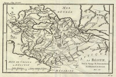
$15.00 Shipping Location: Brooklyn, United States 1987 Bocage Map of Boeotia. Ancient Greece WE SELL ONLY ORIGINAL ANTIQUE MAPS- NOT REPRODUCTIONS Title: La Beotie Pour le Voyage du Jeune Anacharsis. ... moreDescription: This is an attractive 1787 map of Boeotia. One of the regions in Ancient Greece. Cartographically based on an early map by D'Anville, this map is centered on Thebes and details the ancient region's important towns and cities. The map also attempts to illustrate events associated with the Battle of Plataea. The battle of Plataea occurred in 479 BC and was the last battle in the second Persian invasion of Greece. It took place near the city of Plataea in Boeotia, and was fought by an alliance of the Greek city-states, including Sparta, Athens, Corinth and Megara, against the Persian Empire of Xerxes I. The map features Mount Cithaeron, where the tide of the battle turned. The battle concluded with a large portion of the Persian army trapped in their camp where they were slaughtered, essentially brining the invasion to a close. Prepared by M. Barbie de Bocage in 1787 to illustrate the Travels of Anacharsis. Anacharsis was a Scythian philosopher who travelled from his homeland on the northern shores of the Black Sea to Athens in the early 6th century BCE. Apparently he made a great impression on the Greeks, who considered him a forthright, outspoken'barbarian. He is considered a forerunner of the Cynics. Size: Printed area measures 7.5 inches high by 11 inches wide. Condition: Very good. Original platemark visible. Original centerfold. Blank on verso. Dark clean impression. Shipping: Due to recent increases in United States Postal Service rates we have been forced to increase our shipping rates. Shipping rates are not negotiable. Items are shipped within three business days of receiving payment. We are happy to consolidate shipping where possible. The following shipping options are available: 1. USPS Domestic Express Mail(35 USD) USA Only. 2. USPS Priority Mail(15 USD) USA Only. 3. USPS International Express(35 to 55 USD) Recommended service for

Buy It Now
$15.00 Shipping Location: Brooklyn, United States 1878 Migeon Map of Turkey in Asia WE SELL ONLY ORIGINAL ANTIQUE MAPS- NOT REPRODUCTIONS Title: Turquie d'Asie et les Provinces du Caucase. Description: ... moreThis is a fine example of J. Migeon's 1878 map of Turkey in Asia and the Caucuses. Migeon's map covers from the Crimea south to Egypt. West as far as the Aegean, and east to the Caspian Sea and the Persian Gulf. The map essentially covers the mid-19th century claims of the Ottoman Empire, including the modern nations of Turkey, Iraq, Kuwait, Syria, Jordan, Israel or Palestine, Armenia, Georgia, and Azerbaijan, with parts of adjacent Iran, Greece, Egypt and Ukraine. The lower left quadrant includes a beautiful illustration of Smyrne(the ancient city of Smyrna) The map dates to the last days of the Ottoman Empire, whose influence, though rapidly declining, dominated much of the Middle East. Various rivers, islands, mountain passes and other topographical features are identified. Migeon’s Geographie Universelle, published in Paris, is one of the last great decorative atlases of the 19th century. It contains many stylistic elements of early 19th century cartography such as full hand coloring, numerous decorative vignettes, and high quality paper. This map was issued as plate no. 28 in Migeon's Geographie Universelle. Size: Printed area measures 12.5 inches high by 16 inches wide. Condition: Very good. Original centerfold. Blank on verso. Shipping: Items are shipped within three business days of receiving payment. We are happy to consolidate shipping where possible. The following shipping options are available: 1. USPS Domestic Express Mail(25 USD) USA Only. 2. USPS Priority Mail(12 USD) USA Only. 3. USPS International Express(35 to 55 USD) Recommended service for all international parcels. 4. USPS Priority Mail(25 USD) Available to only certain countries. Due to high instances of loss. This service is specifically NOT AVAILABLE to MAINLAND CHINA or INDIA. 5. Federal Express is available upon request. This is the only service option available to India a
Buy It Now
$9.97 Shipping Condition: Unspecified Location: LONDON, United Kingdom Antique atlas map with original hand colouring / coloring, 1856. DATE PRINTED: 1856. PROVENANCE: "General Atlas of the World", by Sidney Hall, William ... moreHughes FRGS &c. new edition, Edinburgh; Adam & Charles Black, North Bridge.
Buy It Now
$19.58 Shipping Location: Mount Waverley, Australia Antique Map 5-050 Persia Empire by Teesdale c.1847 Ancient Persian Empire by Teesdale &;c.1847 Hand coloured steel engraving 41cm X 33cm Condition B (faint ... morebrowning along centre fold). Ancient Persian Empire by Teesdale &;c.1847.
Buy It Now
$8.70 Shipping Location: Kassel, Germany Thebes (ancient Egyptian in the New Kingdom Waset, otherwise also: Niut or Niut-reset) was an ancient Egyptian city in Upper Egypt lying on the Nile. ... moreHomer called it the hundred-gate Thebes in his Iliad (9th cent. Song, v. 3. Singing); he called the Greek Thebes in Boeotia seven gates in the Odyssey (11. singing, v. 2 Singing). In the place of Thebes at the end of the 19th At the end of the 19th century there was only an extensive field of ruins on both sides of the Nile. The temple and city area lay in an alluvial plain, which continued to grow due to recurring artificial deposits. As a protective measure against the Nile flood, dykes were also built, which were intended to protect the temple complex in particular. Today, one of the tourist centers of Egypt, the city of Luxor, is located.
Buy It Now
$14.00 Shipping Location: Beograd 6, Serbia Sardis was the capital of the ancient kingdom of Lydia, one of the important cities of the Persian Empire. This work consists out of several parts/books ... moredescribing important views of nature and art in all parts of the world.
Buy It Now
$6.00 Shipping Location: Israel This map, issued near the end of the 18th century by Charles and Felix Delamarche, shows the various ancient empires that existed east of the Black Sea ... moreand Egypt. It shows the extent of Bactrians, Scythians, Persians and others who occupied the territory in the Middle East and Central Asia to the Caucuses.

Buy It Now
$20.00 Shipping Location: Beograd 6, Serbia RARE ORIGINAL MILITARY TOPOGRAPHIC DETAILED MAP Southwestern BULGARIA Printed in very small circulation. ЏУМАЈА(DZUMAJA. DJOUMAIA) Temporary autographic ... morerelease Pазмер(scale) 1: 200000. Publisher: Географско одељење Главног Ђенералштаба- Србија(Geographical Department of Chief General Staff- Serbia) Print: Department og Brothers Aspiotis on Corfu(Greece) Dimensions: 67.3 x 64,7 cm. Date: printed during WWI. Probable 1916- 1918. Condition: wear. Folded as issued, some small imperfections on the borders, small pale stains. Pale stains on the verso. For condition and details see picture. If you have any questions. Please contact us. This item will be shipped in a cardboard tube. Bulgaria(Bulgarian: България. Balgariya, IPA: b ɤ̞ɫˈɡ arij ɐ] Officially the Republic of Bulgaria(Република България, transliterated: Republika Balgariya, IPA: r ɛˈ publik ɐ b ɤ̞ɫˈɡ arij ɐ] Is a country in Southeast Europe. Bulgaria borders Romania to the north, Serbia and Macedonia to the west, and Greece and Turkey to the south, and the Black Sea to the east. With a territory of 110,994 square kilometers(42,855 sq mi) it ranks as the 15th-largest country in Europe. The economy relies on local natural resources and the strongest sectors are heavy industry and agriculture. The emergence of a unified Bulgarian ethnicity and state dates back to the 7th century AD. All Bulgarian political entities that subsequently emerged preserved the traditions of the First Bulgarian Empire. Which at times covered most of the Balkans and became a cultural hub for the Slavs in the Middle Ages. With the downfall of the Second Bulgarian Empire in 1396, its territories came under Ottoman rule for nearly five centuries. The Russo-Turkish War of 1877–1878 resulted in the establishment of a third Bulgarian state, the independence of which was fully recognized in 1908. Shortly afterwards Bulgaria became involved in a series of major conflicts with its neighbours and allied with Germany in both World Wars. After World War II it became a pe
|
|
|
|
1831 Copper Engraved Map of ANCIENT PERSIAN EMPIRE * Hand Colored * 16x13.25
Auction Wizard 2000 Listing Template- AW2KLOT#5744 Please note that Customs delays for international shipping have been SIGNIFICANT lately- days or even weeks longer than they should be! Please take this into consideration Our goal is 5 star service! If you feel we have not lived up to a 5 star rating. Please contact us as we only want 100% satisfied customers and NO misunderstandings! Description below pictures* 1831 Copper Engraved Map of ANCIENT PERSIAN EMPIRE* Hand Colored* 16x13.25* $78.00 An Original Vintage Antique Map: Not a Reproduction! See Our Ebay Store for other Antique Maps! Free US Shipping on Purchases of $100 value or more of Maps and Prints Description: This is an authentic antique copper engraved print over 180 years old. MAP OF THE ANCIENT EASTERN PART OF THE ANCIENT PERSIAN EMPIRE" Published under the Supervision ... moreof the Society for the Diffusion of Useful Knowledge. 1831. Published by Chapman& Hall, London, December 1, 1831. From the Atlas"Maps of the Society for the Diffusion of Knowledge" Hand colored(outline color) copper plate engraving. On wove paper. Engraved by J. C. Walker. Wonderful detail. A BEAUTIFUL original map which would look fantastic matted and framed! It is being sold as a single sheet. Not mounted, matted or framed as shown in the first picture. Overall a nice print which would mat and frame up very well. Size: Nice size. 16 1/8" x 13 1/2" overall(40.9 x 34.2 cm) as seen in the pictures. Condition: This print is in very good condition for its age with light soiling. Blank on reverse. The image is in very nice condition and will frame up nicely. Some light foxing evident but not prominent. The pictures shown are of the actual print being sold. Shipping: Please use the calculator under the"Shipping and payments" tab above to determine shipping for your location. All packages are sent with Delivery confirmation where possible. We always combine shipping. So on multiple items please wait until we send you an invoice with the correct shippi
|
|
|
1865 Spruner Map - Ancient Persian Empire - Middle East Iran Perisa Greece Italy
Lake Erie Maps& Prints An Authentic Antique Map: Not a Modern Reproduction! Free US Shipping on Purchases of 5 or More Maps or Prints See our Gallery Below and Store Listings for more Great Antique Maps! Description: It is an authentic copper plate engraved antique map with the plate indentions embossed in the margins. It is approximately 158 years old with original handcoloring and a centerfold as issued. Labeled in German. It is from Dr. Karl Von Spruner's Atlas Antiquus(Gotha: Justus Perthes. 1865) A copy of the Atlas title page with date is included for authenticity. The abbreviated title of the Atlas is in the upper right and the publisher's name is in the bottom center. Size: The map image area measures approximately 13 by 16 1/2(33x42cm) inches on a 15 by 18 1/2" 38x47cm) page with a margin all around for matting. ... moreAs seen in the main pic. Condition: It is in Excellent condition. Printed on heavy paper with original hand coloring, blank on the reverse. No defects to mention. The pics are of the actual map. Payment Details: We accept most major credit cards through Paypal and Ebay. Please ask if you have any questions about payment. International and New Bidders are welcomed and encouraged. Payment is expected within 7 days. After which Nonpaying Bidders will be reported to Ebay to recoup our listing fees. Save on Shipping: We only charge one shipping fee based on the largest map or print with multiple items shipped along with it for no extra costs. Purchase 5 or more maps or prints and receive Free First Class shipping in USA or First Class International elsewhere in the world. Although registration may be required on shipments of high value. Shipping to Brazil. Russia, Ukraine is $26 for First Class Registered Mail($14+$12) since postal insurance has been discontinued to these countries. We will send a corrected invoice when purchased. We are glad to ship as many maps and prints as you want for the one shipping price. International Customs and VAT Fees: It is the responsibility of the buye
|
|
|
Original 19thC Hand-Coloured Map - ANCIENT PERSIAN EMPIRE, Eastern - SDUK
THE EASTERN PART OF THE ANCIENT PERSIAN EMPIRE by G. Long M.A. 1831 Published under the Superintendence of the Society of the Diffusion of Useful Knowledge London: C. Knight& Co. Engraved by J. C. Walker Scale: approx. 90 miles to one inch Sheet size: 16½" x 13½" This is a genuine antique map. Not a reproduction. As such, some age toning or signs of handling are to be expected. Any significant flaws or defects beyond this are noted below. Original engraved map with hand-coloured boundaries. Good condition. Disbound. With perforations along lower margin. Slightly tanned around edges and chipped, with tears to left and top margins. A few spots of foxing to lower left, some dusty marks and signs of handling. Click on pictures to enlarge in a new window I am happy to answer questions or provide whatever information I can. ... moreReturns I have tried to provide a description that is fair and accurate. Full refund. Plus cost of return postage, if this lot has been misrepresented. If. For any other reason, you are not satisfied with your purchase, I will give a full refund. But postage may be at buyer's expense. Payment PayPal Cheques drawn on any UK account Direct Bank Transfer Banker's Drafts or Postal Orders in GB£ only Buyers outside the UK: PayPal only Please make payment within 7 days. Thankyou Postage Postage by 2nd class mail to the UK. Or standard airmail. Alternative delivery methods at buyer's request. I will combine postage for multiple lots wherever possible.
|
|
|
1844 LARGE ANTIQUE TEESDALE MAP ANCIENT PERSIAN EMPIRE
1844 LARGE ANTIQUE TEESDALE MAP ANCIENT PERSIAN EMPIRE Description: FINE LARGE NINTEENTH CENTURY STEEL-LINED ENGRAVED MAP OF THE ANCIENT PERSIAN EMPIRE. DRAWN AND ENGRAVED BY J. DOWER AND PUBLISHED BY HENRY TEESDALE, LONDON, c1844. A large finely detailed nineteenth century steel-lined engraved map. Neatly hand-coloured in outline, of the Ancient Persian Empire, engraved by J. Dower and published by Henry Teesdale, in London, c1844. The double-page map with printed title and with separate scale of distance. Image size approx. 34cm x 41cm(13.25in x 16.5in) A generally VG+ bright clean impression. With a few light marks to extreme lower margin, of this detailed map. All maps will be sent out in board-backed envelopes for extra protection. A GURANTEED GENUINE ORIGINAL NINETEENTH CENTURY MAP Shipping UK Recorded Delivery £4.00 Europe Printed ... morePapers(2-5 days) £5.00 U.S.A. and the Rest of the World Printed Papers(up to 5 days) £6.00*Reduced shipping for multiple purchases Payment: What payment methods are taken and by when should payment be made? I offer a variety of payment methods. UK customers can pay by PayPal. Direct by credit card, postal order and personal cheque. Non-UK customers can pay by PayPal, or by an alternative method if agreed prior to purchase. Payment should be received within 7 days of purchase unless otherwise agreed. I reserve the right to relist an item for sale if payment is not made at the latest within one month of purchase. Payment protection cover Customers who pay by PayPal are automatically covered by PayPal's Buyer Protection scheme up to £500 assuming buyer and seller meet certain criteria. See PayPal's website at www.paypal.com for terms. Likewise, other buyers are automatically covered by eBay's Standard Purchase Protection Programme up to £120 as long as certain criteria are met. See eBay's website at www.ebay.co.uk for terms. What is PayPal? PayPal is a secure payment system owned by eBay which allows customers and merchants to exchange money
|
|
|
1831 MAP OF THE EASTERN PART OF THE ANCIENT PERSIAN EMPIRE * Hand Colored Engrav
1831 MAP OF THE EASTERN PART OF THE ANCIENT PERSIAN EMPIRE* Hand Colored Engrav Click Images to Enlarge An Original Vintage Antique Copper Engraved Map: Not a Reproduction! See Our Ebay Store for other Antique Items! Please visit our parent eBay store(abetteronlinebookstorellc. Feedback over 17,000! Free US Shipping on Purchases of $100 value or more! If you are searching for a REAL and AUTHENTIC piece of history to decorate or display on your walls. Or that unique gift for the discerning collector, a Vintage Antique Map is the perfect choice. A properly displayed Vintage Antique Map will enhance any room and bring that piece of history to life! All of our Vintage Antique Maps are guaranteed to be authentic to the time period described. If we can help you with your choice or answer any questions you may have. Please feel free to contact us ... morethrough the"contact the buyer" link. Details Full Title: THE EASTERN PART OF THE ANCIENT PERSIAN EMPIRE Year: 1831. Dec. 1st. Publisher/Printer: by G. Long. Prof. Greek, London University. Published by Baldwin& Cradock. 47 Paternoster Row, London. Published under the Superintendence of the Society for the Diffusion of Useful Knowledge. Engraved by J. C. Walker. Engraving style: Copper plate engraving on fine paper Condition Grade: Collectible. Very Good Authentication: Appraisal Valuation Sheet available Appraised Value: $170.00 Approximate Sheet Size(inches) 16 x 13" Approximate Sheet Size(Cm) 40.6 x 33 Description Ancient Persian Empire as it was during the time of Ptolemy and the Romans This is an authentic antique map approximatley 180 years old! Blank on reverse. Some light foxing evident. Not too bad. The map is not mounted, matted or framed and is being sold as a single sheet as shown in the picture. This map is in Very good to Fine condition. It is clean and still has strong presence. Very light wear. It is basically as seen in the pics. Very clean and would frame up nicely, see pictures for more on condition. The pictures shown are of the actual map
|
|
|
ANCIENT PERSIAN EMPIRE. Shows retreat of 10,000 Greeks. Cyrus Younger, 1876 map
Armenia. Mesopotamia, Babylonia, and Assyria Antique colour map. 1876 Title of map: Armenia. Mesopotamia, Babylonia, and Assyria' The image below shows an enlarged cross section from the centre of the map to show the level of printed detail: DATE PRINTED: 1876 IMAGE SIZE: Approx 22.5 x 15.5cm. 8.75 x 6 inches(Medium) ARTIST/CARTOGRAPHER/ENGRAVER: J. Bartholomew. Edinburgh PROVENANCE: The Library Atlas" by James Bryce. William F. Collier, Leonhard Schmitz; Published by William Collins, London[First edition] TYPE: Antique colour map VERSO: There is nothing printed on the reverse side. Which is plain CONDITION: Good; suitable for framing. However. Please note: The image shown may have been taken from a different example of this map than that which is offered for sale. The map you will receive is in good condition but there may be minor ... morevariations in the condition from that shown in the image. Please check the scan for any blemishes prior to making your purchase. Virtually all antiquarian maps and prints are subject to some normal aging due to use and time which is not obtrusive unless otherwise stated. I offer a no questions asked return policy- see below. AUTHENTICITY: This is an authentic historic print. Published at the date stated above. I do not offer reproductions. It is not a modern copy. The term'original' when applied to a print means that it was printed at the first or original date of publication; it does not imply that the item is unique. Print' means any image created by applying an inked block to paper or card under pressure by any method including wood engraving, steel engraving, copperplate, wood cut and lithography. REMARKS: FRANCE: Gravures et Cartes anciennes. DEUTSCHLAND: Alte Lankarten und Stadt ansichten. ITALIA: Stampe e Mappe antiche. ESPAÑA: Mapas antiquos y impresiones antiguas. E and OE. Force Majeure. English law shall apply. RETURNS POLICY: I offer a no questions returns policy. All I ask is that you pay return shipping and mail back to me in original condition.
|
|
|
SDUK 1831 Antique Map. Eastern Part of the Ancient Persian Empire
Antique Steel Engraved Map Published 1829-46 by Baldwin& Cradock and/or Chapman and Hall for"Maps by the Society for the Diffusion of Useful Knowledge" by The SDUK. Very minor toning. Paper Size: 16 x 13.5 inch(41 x 34cm) Approx
|
|
|
1831 PERSIAN EMPIRE SDUK Map Ancient Persian Empire Persis Karmania Original
TITLE THE EASTERN PART OF THE ANCIENT PERSIAN EMPIRE DATE-1831 BOTTOM CENTER PUBLISHED BY SOCIETY FOR THE DIFFUSION OF USEFUL KNOWLEDGE BALDWIN AND CRADOCK LONDON THIS AUCTION IS FOR AN ORIGINAL HAND-COLORED MAP OF THE EASTERN PART OF THE ANCIENT PERSIAN EMPIRE. MAP SHOWS ARABIA. GREAT MEDIA, KARMANIA, CASPIAN SEA, AND ASSYRIA. MANY VILLAGES AND ANCIENT SITE ARE SHOWN AS WELL. MEASURES 11 X 14 INCHES CONDITION- FAIR. FOXING/DISCOLORATION
|
|
 |