-
Christian Collectibles
-
Christian Sheet Music
-
Vatican Stamps
-
Vatican Coins & Paper Money
-
Antiques
-
Antiquities
-
Architectural & Garden
-
Decorative Arts
-
Ethnographic
-
Furniture
-
Maps, Atlases & Globes
-
United States (Pre-1900)
-
AK, HI
-
AL, FL, GA, MS, NC, SC
-
AR, IA, KS, LA, MO, NE
-
AZ, CA, CO, NM, NV, UT
-
CT, MA, ME, NH, RI, VT
-
DC, DE, MD, NJ, NY, PA
-
ID, OR, WA
-
IL, IN, MI, OH, WI
-
MN, MT, ND, SD, WY
-
OK, TX
-
VA, WV, KY, TN
-
Entire US
-
United States (1900-Now)
-
United States (Date Unknown)
-
Africa
-
Asia
-
Australasia/ Oceania
-
Canada
-
Central America/ Caribbean
-
Europe
-
India
-
Ireland
-
Mexico
-
Middle East
-
North America
-
South America
-
United Kingdom
-
Maps on CD
-
World Maps
-
Globes
-
Mixed Lots
-
Reproductions
-
Price Guides & Publications
-
Other
|
In
Order by: Available to: This site contains affiliate links for which I may be compensated
|
Buy It Now
$3.95 Shipping Location: Clarkston, United States Indian land cessions in the. Smithsonian Institution. Eighteenth annual report. 1896-1897. Title from cover. State of Kansas, 1884; compiled from the ... moreofficial records of the General Land Office and other sources under supervision of G.P. Strum, Principal Draughtsman, photo lith & print by Julius Bien & Co.
Buy It Now
$5.00 Shipping Location: League City, United States This map has been carefully removed from the atlas it originally appeared in and is perfect for display purposes. It may have writing or other images ... moreon the reverse side of it. It is in very good condition for its age with overall tonal aging and yellowing on the edges.
Buy It Now
$5.95 Shipping Condition: New Location: Las Vegas, United States Each of our prints are custom reproductions printed on 68lb Heavyweight Enhanced Matte Art Paper. These Historic Art Prints are suitable for framing, ... moremounting or direct display on any wall! “Vibrant and bright!
Buy It Now
$6.15 Shipping Location: Bar Harbor, United States Outlaws ran rampant, and violence and mob justice ruled. In 1886, the Secretary of the Interior declared it was public domain, subject to squatter’s rights. ... more1886 Original Antique Mitchell Map. Mitchell's Modern Atlas.
$6.00 Shipping Location: Monroe, United States TREATY LAND CESSIONS SHOWN ARE FOR THE 1807 CHICKASAW LANDS(SHOWN IN BLUE), THE 1816 CHICKASAW TREATY(SHOWN IN ORANGE) AND THE 1832 CHICKASAW LAND CESSION ... moreTREATY(SHOWN IN YELLOW). DATE-1899, NOT ON MAP.

Buy It Now
$4.50 Shipping Location: Anderson, United States The Historical Archive Sample Page Atlas of Indian Land Cessions In the United States 67 Rare Historical Maps This CD contains 67 rare antique maps of ... moreIndian Land Cessions in the United States in MrSid format. This format allows you to see the entire map on your computer screen or drill down to see the smallest details. The original maps are often quite large. As much as 36" long or larger and quite detailed. With the MrSID software, you can manipulate the map to print the entire map in great detail or zoom into a portion of the map in full detail for viewing or printing. You could even bring the images to a local print shop to have the maps reprinted in their full size. MrSID software is included on the CD. To give you a sample of the detail you can expect in these maps. Here is an example based on a panoramic map of Washington, DC. The table below shows the description and a small image of each map on this incredible history CD. Alabama Alabama(northern portion) Arizona 1 Arizona 2 Arkansas 1 Arkansas 2 California 1 California 2 Colorado 1 Colorado 2 Dakota 1 Dakota 2 Dakota 3 Florida Georgia Idaho Illinois 1 Illinois 2 Indiana Indiana(detail) Indian Territory 1 Indian Territory 2 Indian Territory 3 Iowa 1 Iowa 2 Kansas 1 Kansas 2 Louisiana Michigan 1 Michigan 2 Michigan(Saginaw bay to Lake Erie) Michigan(region about Mackinac and Detroit) Minnesota 1 Minnesota 2 Minnesota(northern portion) Mississippi Missouri 1 Missouri 2 Montana 1 Montana 2 Nebraska Nebraska(eastern portion) Nevada New Mexico 1 New Mexico 2 New Mexico and Texas(detail) New York North Carolina Ohio Ohio(detail) Oregon 1 Oregon 2 Pennsylvania Tennessee and bordering States Tennessee(detail) Tennessee and Alabama(portions of) Texas(portion of) Utah 1 Utah 2 Washington 1 Washington 2 Washington(along Admiralty inlet) Washington(northwestern) Wisconsin 1 Wisconsin 2 Wyoming 1 Wyoming 2 This is a must have collection for any historic map or American Indian history buff! To use this software. You must install the free ExpressView Mr
Buy It Now
Free Shipping Location: Carefree, United States ORIGINAL ANTIQUE 1880 AGRICULTURAL BUCKWHEAT PRODUCTION MAP OF THE UNITED STATES. ORIGINAL ANTIQUE 1880 AGRICULTURAL MAP OF THE UNITED STATES. BEAUTIFULLY ... moreCOLORED AND VERY DETAILED MAP SHOWINGTHE RELATION BETWEEN THE PRODUCTION OF BUCKWHEAT IN BUSHELS AND THE AREA OF IMPROVED LAND IN ACRES.
Buy It Now
$10.05 Shipping Location: Belvedere Tiburon, United States In other newly incorporated areas, things were still up in the air. As with Oklahoma, which in 1825 had officially been classified as ‘Indian Territory,’ ... morethe northern plains are so densely inhabited by First Nation peoples that their lands have been color-coded to distinguish between their respective domains.
Buy It Now
$5.95 Shipping Condition: New Location: Las Vegas, United States Year: 1835. “Vibrant and bright! Pic does not do it justice.looks amazing!”. Each of our prints are custom reproductions printed on 68lb Heavyweight Enhanced ... moreMatte Art Paper. These Historic Art Prints are suitable for framing, mounting or direct display on any wall!
Buy It Now
$4.55 Shipping Location: Oakland, United States 12x10 inches This antique map features the states of Texas and Oklahoma, previously known as Indian Territory, as well as public land. The colorful and ... moreintricate design of the map is sure to catch the eye of any collector interested in North American maps from the late 19th century.With its detailed representation of geographical features and landmarks, this map is a valuable addition to any antique collection. Whether you're a history buff or simply appreciate the beauty of vintage cartography, this 1885 map is a must-have for your collection.
Buy It Now
$8.50 Shipping Location: Croatia Originally “all of that part of the United States west of the Mississippi, and not within the States of Missouri and Louisiana, or the Territory of Arkansas.”. ... moreNever an organized territory, it was soon restricted to the present state of Oklahoma, excepting the panhandle and Greer county.
Buy It Now
$4.15 Shipping Location: Saco, United States Up for Sale is a Dated 1886 Colored Map of the Indian Territory which Joined Statehood as Oklahoma in 1907. Colorado is on the reverse side.This Map was ... moreHarvested from an 1890 Rand McNally New Family Atlas as shown in the last photo.
Buy It Now
$4.99 Shipping Location: Fairview, United States It is from Warren's Common- School Geography, published in Philadelphia by Cowperthwait & Co., circa 1889, showing North and South Dakota after the split ... morein 1889 and the Unassigned Lands of Oklahoma in the middle of Indian Territory.
Buy It Now
$11.85 Shipping Location: Dover, United States Issued 1890, NY by Scribner & Black. Scarce oversized folio sheet late 19th century color lithographed map. Texas and Indian Territory.
Buy It Now
$14.00 Shipping Location: Canada Williams, G. :MAP: MAP OF UPPER CANADA SHEWING THE PROPOSED LAND AGENCY DIVISIONS (51" X 48"). Published in 1857, 1st Edition. Published by Stewart Derbishire ... more& George Desbarats,,Published by Commissioner of Crown Lands.
Buy It Now
$11.85 Shipping Location: Dover, United States Issued c.1811, London by John Cary. Fordham, John Cary. Map Collector 43, pp. 40-47 (Cary Family) and #57, pp. 32-7 (English Atlas). (Arabia- Hindostan- ... moreIndia- Persia- Chinese Empire- Australia- New Holland Pacific islands- Indian Ocean).
Buy It Now
$6.00 Shipping Location: Greenacres, United States On the reverse side there is a map of Oregon, Washington, Idaho, and Montana in similar style and format. It was published inMitchell's New General Atlas, ... moreby Samuel Augustus Mitchell, Philadelphia, 1880.
Buy It Now
Free Shipping Location: Schertz, United States This authentic 1884 map features the state of Minnesota and specifically highlights the Red Lake Indian Lands. Printed using the lithography technique ... moreby Rand McNally & Co., this antique original map is a unique piece of history. Measuring 15x21 inches, it is perfect for collectors or anyone interested in the history of Minnesota and the United States. Take advantage of our free shipping and handling within the USA, or if you're an international buyer, our calculated shipping and handling rates will ensure that this valuable piece of history arrives safely at your doorstep. Don't miss out on the opportunity to own this one-of-a-kind map.
Buy It Now
Free Shipping Location: Schertz, United States This Map was removed from a 1902 CRAM'S ATLAS and is in very good condition. The map is not " new " or in " new " condition, it was printed in 1902. The ... moremap is not dated.
Buy It Now
Free Shipping Location: Portland, United States CANYON DE CHELLY. ANCIENT PUEBLO REGION. (14" x 11.5") // 2. (11.5" x 18"). Lithographic Printing By Julius Bien of New York. Rare treasures being added ... moreregularly, so be sure to add us to your favorites, so you don't miss out!
Buy It Now
Free Shipping Location: Schertz, United States This Map was removed from a 1887 Cram's Atlas and is in good acceptable condition. The map is not " new " or in " new " condition, it was printed in 1887. ... moreThe map is not dated. Study the photos carefully, this is the actual map you will receive.
Buy It Now
$4.69 Shipping Location: Greenacres, United States
$29.55 Shipping Location: WATERLOOVILLE, United Kingdom The map is bordered by a neatline identifying latitude and longitude, while the title of the map appears in bolded letters in the bottom-left corner. ... moreA note below the neatline explains that, while originally prepared by the South African firm Juta, it was also published in London by Edward Stanford.
Buy It Now
Free Shipping Location: Northford, United States Map, [1836?]. Publisher:[publisher not identified], [Washington, D.C.], [1836?]. Shows district, grant and cession boundaries. Two-sheet map joined, with ... morehint of glue staining at centerfold, as usual with a few tiny fold breaks.
Buy It Now
Free Shipping Location: Cochiti Lake, United States Old Georgia Map - Historical Notes - Modern Print Georgia 1788 map. Georgia became the 4th State to ratify the United States Constitution, January 2, ... more1788. Georgia was the 2nd state to enter the Union as a slave state. One of the original 13 Colonies. Georgia joined the Confederate States of America, January 26, 1861...and was re-admitted to the Union, July 15. 1870. Details show large areas of Indian Land prior to 1783. Details The Great Seal of the State of Georgia. . Very colorful map printed on parchment paper. Image size 12" x 16". Copyright 1986 Fletcher & Boeselt Cartographers, All Rights Reserved. Very hard to find this map, limited prints! Map is rolled in a clear plastic sleeve and shipped in a sturdy tube.
Buy It Now
$10.04 Shipping Condition: Unspecified Location: LONDON, United Kingdom TYPE: Antique engraved map. 1849 copy of an earlier map. This map was published in 1849 but it may depict an earlier representation of the area shown ... moredated 1797 and the mapmaker may have drawn on an earlier original work.
Buy It Now
$25.00 Shipping Location: Belvedere Tiburon, United States ANTIQUE MAP SHOWING INDIAN RESERVATIONS WITHIN LIMITS OF THE UNITED STATES. ELEVENTH CENSUS OF THE UNITED STATES, 1890. SEE PHOTOGRAPHS. SEE OUR OTHER ... moreSTORE ITEMS.
Buy It Now
Free Shipping Location: Clovis, United States All in good condition. Well cared for. Land of Maya A Traveler's Map. A Traveler's Map of Spain and Portugal. Special Places of The World Holy Land.
Buy It Now
$6.95 Shipping Location: Dover, United States Issued Phila, c.1889 by Wm. Bradley. Indian Territory. Oversized late 19th century map with original hand color. Fine level of detail, decorative piano-key ... moreborder surrounds the map.
Buy It Now
$6.95 Shipping Location: Dover, United States Indian Ocean Distribution of Oceanic Deposits. Scarce late 19th century color lithographed map issued for the Scottish Geographical Magazine, possibly ... moreunique to that publication. Uncommon 19th century oceanography thematic map.
Buy It Now
$16.60 Shipping Location: Dover, United States Old Oregon Trail. Light uniform paper age toning, overall waviness to sheet, faint light old damp staining across bottom edge, remaining clean - a pleasing ... morevisual example of this delightful map. Apparently also re-issued in 1959, this appears to be the First issue.
Buy It Now
$6.95 Shipping Location: Dover, United States (Islands, Africa, Comoro Islands). Issued 1748, Paris. Engraved by Bellin. Charming mid-18th century engraved map, with lovely hand color. Original fold ... moreline as issued.
Buy It Now
$6.00 Shipping Location: Sonora, United States A very nice map veryclear printing in pristine condition.
Buy It Now
$6.00 Shipping Location: Greenacres, United States
Buy It Now
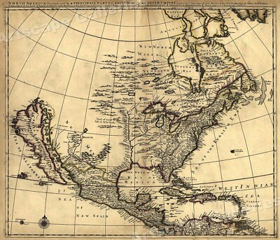
$5.95 Shipping Condition: New Location: Las Vegas, United States North America 1685 Size: 24" x 28" 61 cm x 86 cm) x Also Available in from our eBay Store This is a great Classic Map originally Published circa ... more1685. This Map shows what was known of America(North America) in1685. The wording reads: North America divided into its III principall parts. Features include: New North Wales" Canada) Bay of Mexico" Gulf of Mexico) Sea of the English Empire" Atlantic Ocean) West Indian Sea" Caribbean) Sea of California" Sea of New Spain" Pacific Ocean) New Mexico" Western United States) and"Tract of Land full of Wild Bulls" Great Plains) This poster. Which evokes the vivid images of a simpler time, is a custom reproduction printed on 68lb Heavyweight Enhanced Matte Art Paper. This Historic Art Print is suitable for framing. Mounting or direct display on any wall! 000 Artscape Galleries/ Posters Past More Prints and Posters Available from our eBay Store! Shipping price includes delivery confirmation. We combine shipping for multiple purchases- add $1.00 for each additional poster. All posters are professionally packaged to ensure that they arrive safely and undamaged: Your poster is first rolled and inserted into a plastic sleeve before being placed into a Heavy-Duty mailing tube for delivery. We stand behind the quality of every poster. If you are not satisfied with your purchase. Please contact us within 30 days to arrange for either an exchange or a full refund. gsrx_vers_468(GS 6.4(468)
Buy It Now
$33.55 Shipping Location: Crested Butte, United States STATE OF COLORADO. GENERAL LAND OFFICE. the Land Office and other sources. Condition: original, rolled, near fine to fine condition, slight stain on right-hand ... moremargin, easily covered with a mat. Maxwell land grants;.
Buy It Now
$10.04 Shipping Condition: Unspecified Location: LONDON, United Kingdom Antique colour map, 1892. DATE PRINTED: 1892. CONDITION: Good; suitable for framing. The map you will receive is in good condition but there may be minor ... morevariations in the condition from that shown in the image.
Buy It Now
Free Shipping Location: Carefree, United States RARE ORIGINAL 1903 ANTIQUE MAP OF THE UNITED STATES SHOWING PRODUCTION OF BARLEY PER SQUARE MILE. ORIGINAL ANTIQUE 1903 MAP OF THE UNITED STATES SHOWING ... morePRODUCTION OF BARLEY PER SQUARE MILE. GOOD CONDITION, DISCOLORATION AND CENTER CREASE AS ISSUED.
Buy It Now
$6.95 Shipping Location: Dover, United States Issued 1856, United States. (Pacific Ocean, Indian Ocean, Perry Expedition, U.S. Japan Expedition, U.S.S. Mississippi, Japan, Southeast Asia, Philippines, ... moreAustralia, Indonesia, India).
Buy It Now
$6.95 Shipping Location: Dover, United States Issued 1856, Edinburgh by William Blackwood and Sons. Engraved by W & A.K. Johnston. Detailed and lovely large mid 19th century color lithographed folio ... moremap with piano key border.
Buy It Now
$4.95 Shipping Location: Dover, United States Issued for a 1939 World's Fair publication, printed with unrelated text on the reverse. Charming little mid-20th century pictorial map worthy of framing ... morefor display. Issued 1939, New York, art work by Norman Reeves.
Buy It Now
$6.00 Shipping Location: Greenacres, United States Bowen, Geographer to his Majesty 1747.". Emanuel Bowen (1694-1767) achieved the unique distinction of becoming Royal Mapmaker to both King George II of ... moreGreat Britain and Louis XV of France. A large area of the northwest coast, predating Cook's explorations, is labeled "Parts Undiscovered.".
Buy It Now
Free Shipping Location: Schertz, United States This Map was removed from a 1902 CRAM'S ATLAS and is in very good condition. The map is not " new " or in " new " condition, it was printed in 1902. The ... moremap is not dated.
Buy It Now
$11.66 Shipping Location: Latvia Antique map "NORTH AMERICA. USA. CENTRAL STATES WITH INDIAN RESERVATIONS". Circa 1892. Sheet size - 30,3 x 25 cm. Image size - 27,6 x 22 cm. The other ... moreside - clear. Source - Brockhaus Konversations Lexikon, 14.Auflage. Condition - Please check attached photogrphy and scanned images. Combined postage available!!! Shipping - WORLDWIDE Attention German buyers!!! Since my activity has been restricted by German Ebay, please contact me privately, you can find my contact information in the last picture of each ad
Buy It Now
$5.95 Shipping Condition: New Location: Las Vegas, United States This is a great Classic Map originally Published circa 1685. “Vibrant and bright! Pic does not do it justice.looks amazing!”. Each of our prints are custom ... morereproductions printed on 68lb Heavyweight Enhanced Matte Art Paper.
Buy It Now
$8.95 Shipping Location: Akron, United States Original Antique Map from Rand, McNally & Co.’s “Indexed Atlas of the World”, c. 1894. An attractive view of the state as it existed in the 1890’s. UTAH ... moreIN THE 1890’s.
Buy It Now
$5.95 Shipping Location: Bar Harbor, United States Proposed Nicaragua Canal. It consisted of the western area of what is now the State of Oklahoma. The eastern area consisted of the last remnant of Indian ... moreTerritory. The Indian Territory was gradually reduced to what is now Oklahoma; then, with the organization of Oklahoma Territory in 1890, to just the eastern half of the area consisting of the Cherokee, Creek, Chickasaw and Choctaw Nations.
Buy It Now
$4.69 Shipping Location: Greenacres, United States The map was published by George F. Cram, Chicago, in 1889 and is titled "Map of the Oklahoma Country in the Indian Territory.".
Buy It Now
$10.04 Shipping Condition: Unspecified Location: LONDON, United Kingdom Antique wood-engraved map; Scale 1:900,000, 1885. DATE PRINTED: 1885. 'Land of the Zuñi Indians'. Title of map:'Land of the Zuñi Indians'. The image below ... moreshows an enlarged cross section from the centre of the map to show the level of printed detail.
Buy It Now
Free Shipping Location: Grass Valley, United States Pre-owned condition. In excellent condition for age.
Buy It Now
$5.00 Shipping Location: Wabash, United States Black Hills - Mountain Vacationland of South Dakota. Says “Official Map of Rapid City”.
$44.99 Shipping Location: Ivanhoe, Australia Bellin, despite his extraordinary success, may not have enjoyed his work, which is described as \\\"long, unpleasant, and hard. The map is dedicated to ... moreAntoine-Louis Rouillé, comte de Jouy (1689 - 1761).
Buy It Now
$4.55 Shipping Location: East Norwich, United States TITLE: MAP OF THE FRONTIERS OF THE NORTHERN COLONIES WITH THE BOUNDARY LINE ESTABLISHED BETWEEN THEM AND THE INDIANS AT THE TREATY HELD BY S. WILL JOHNSON ... moreAT FT. STANWIX IN NOVEMBER 1768. THIS IS AN 1849 PRINTING OF A MAP FIRST PUBLISHED IN 1768.
Buy It Now
$5.95 Shipping Condition: New Location: Las Vegas, United States Year: 1685. This is a great Classic Map originally Published circa 1685. “Vibrant and bright! Pic does not do it justice.looks amazing!”. Each of our ... moreprints are custom reproductions printed on 68lb Heavyweight Enhanced Matte Art Paper.
Buy It Now
Free Shipping Location: Monroeville, United States Date - 1844. The new lands of each tribe are delineated. Size - map about 4.5x7.25", mat opening about 5x7.5", matte size about 8.5x11", Lithograph. Type ... more- The map was professionally mounted and enclosed in a white matte.
Buy It Now
$25.00 Shipping Location: Belvedere Tiburon, United States These created much more well-defined print lines, allowing even minute features and labels to stand out clearly. By 1882, most states or territories had ... morebeen defined, so we find them present and labeled.
Buy It Now
$5.95 Shipping Condition: New Location: Las Vegas, United States A New and Accurate Map of New Jersey, Pensilvania, New York and New England. “Vibrant and bright! Pic does not do it justice.looks amazing!”. Each of ... moreour prints are custom reproductions printed on 68lb Heavyweight Enhanced Matte Art Paper.
Buy It Now
$6.95 Shipping Location: Dover, United States Texas - Oklahoma - Indian Territory. Late 19th century antique color lithographed map. Original fold lines as issued.
Buy It Now
$6.95 Shipping Location: Dover, United States Issued 1850, Paris. Engraved by Dyonnet. Ile Bourbon. Mid 19th century engraved map with original hand color. Decorative vignettes greatly enhance visual ... moreappeal.
Buy It Now
$6.95 Shipping Location: Dover, United States Issued 1879, Philadelphia by O.W. Gray. Map by Frank Gray. Note how Oklahoma and Indian Territory divide the future state, Alaska is labelled as a "territorial ... moredistrict". Inset at top of Westward expansion from 1790 to 1880.
|
|
|
In
|
1899 Antique COLOR Map of UTAH with INDIAN LAND CESSIONS & VILLAGES/FORTS/B
THIS ITEM IS A GENUINE ORIGINAL VINTAGE MAP FROM THE SOURCE/DATE LISTED Name- Utah Date- published 1899. Includes efforts through 1896/97 Source- Eighteenth Annual Report of the Bureau of American Ethnology By- J. W. Powell. Director Comments- These unusual maps are the results of many years efforts by the Bureau in determining which lands in each States were obtained by the United States Government through various Treaties. Cessions, etc. Also, shows many locations of other features not shown on most other types of State maps. The following items are featured: Areas ceded by Identified Indian Tracts through Treaties or other Cessions. Locations of Early American Forts Locations of Early Indian Villages Rivers and Streams Details of some of the Treaties Location of larger present-day towns Township lines in applicable states etc. In addition ... moreto the color map. You will receive general descriptions of several of the Treaties, Cessions, or Reservations which are identified on the map, including tribe names, historical data, etc Size- about 11.25x14.5" Double page chromolithograph Condition- Fine. But fairly light indications of a corner jam which was primarily absorbed by the hardback binding but resulted in some waviness in one or more corners, not near the image itself. Yes! We Do Combine Shipping on Multiple Purchases! NO RESERVE! Happy Bidding! Buyer pays shipping/packing. We use very secure packaging methods and materials. And all shipments within the United States will be made with the protection of the new USPS Parcel shipping category. First Class or Priority. Depending on weight) Note that certain items may be shipped in the USPS Media Mail category. If appropriate. Payment due within 14 days after our initial after auction contact. Pennsylvania residents MUST add applicable SALES TAX or send resale number. Thanks. Good Luck! To See Our Other Auctions and Store Items CLICK HERE! Powered by
|
|
|
ANTIQUE UNITED STATES LAND SURVEY MAP COLORADO TEXAS INDIAN TERRITORY DAKOTA NR
Click Here. Double your traffic. Get Vendio Gallery- Now FREE! Vintage large fine antique 1892 handcolored map. The map is in gorgeous condition. The map is titled Analysis of the System of United States Land Surveys. Copyrighted 1890, Metes and Bounds and Meridians and Base Lines. Great period handcolored map of the United States, with Texas, Oklahoma as Indian Territory, North and South Dakota as Dakota, and much more. I like how the 1890 copyright is right below the title it dates the map nicely. Interesitng map showing how the United States land surveys were done. The map is printed on thick paper.his is an antique map and not a reprint or reproduction. The handcoloring on the map is period to the map, this is before color printing. The map is from the very rare 1892 Ogle Atlas of LaPorte County Indiana. The map is a fascinating and historic ... moreperiod look at this area at this time. The photo wont show the full beauty of the map. The size of the map is 14" by 17.5" Winning bidder pays $4.00 shipping domestic, more foreign. Please see my eBay store for other rare maps for sale, at very reasonable prices. Payment I accept the following forms of payment: PayPal Click to View Image Album Shipping& Handling US Shipping. $4.00 USPS First-Class Mail® International Shipping. $11.50 USPS First-Class Mail International FREE scheduling. Supersized images and templates. Get Vendio Sales Manager. FREE scheduling. Supersized images and templates. Get Vendio Sales Manager. 40g.RcmdId ViewItemDescV4,RlogId p4%60bo7%60jtb9%3Fuk%601d72f%2B%3E40g-146cbea1ab3-0x10d-
|
|
|
New Mexico Indian Reservations Granted Land 1888 antique detailed color map
New Mexico Printed 1888. Chicago by Rand, McNally& Co. Fine and uncommon original antique offset color printed map in clean well preserved condition. Folio size sheet. Overprinted in yellow. Green& pink at bottom right showing unconfirmed as well as confirmed grants, yellow for Indian Reservations. Not to be confused with the far more common smaller 4to issue. This scarce oversize folio sheet map is very large by cartographic standards. With a myriad of details simply not possible to present on a smaller format map. Further. The details displayed are transitional[temporary] in nature given the rapid expansion around the world during this era. Variant details from other years of issue. An uncommon map only issued within a huge[and then] expensive large format 2 volume edtion atlas printed& distributed in but small numbers at a ... morevery large price. Printed on quality period paper which may show typical gentle signs of age. Perhaps some minor light spotting or foxing, but retains its inherent structural flexibility and soundness. An appealing. Uncommon and interesting map. In near Very Good or better antiquarian condition. Right blank margin trimmed very narrow to border. Mostly clean overall, light minor age dustiness or small light surface wear, small spotting- please inspect enlargable photo closely, any noteworthy flaws to the printed surface area should be noticable within picture provided. Text on verso as issued. In all. A fine map entirely worthy of ownership and display. note: We grade very conservatively and always seek to disclose any noteworthy flaws. We are doing our best to show& describe this item so you are happy when it arrives] Despite any small age flaws. The printed area remains visually pleasing, and the print is well preserved. Overall a nice impression of an original and interesting antique map that any collector. Curator or institution would be happy to own or display. Sheet measures c. 14 1/2" W x 21 7/8" H. Printed area measures c. 12 7/8" W x 18 1/2" H. 666
|
|
|
Arizona Colorado River Phoenix 1899 antique Indian Land Cessations map
Arizona(Little Colorado River. Kingman, Solomonsville, Tuscon) Issued 1899. Baltimore by A. Hoen& Co. for the Bureau of American Ethnology Fine original antique color lithographed map. Printed in the 19th century, on quality paper which retains its inherent structural flexibility and soundness. Interesting and uncommon map which depicts in detals lands ceded to the U.S. government by Indian tribes within the area shown. In VG or better condition. Light minor age toning, overall very presentable and attractive. Please view scan. It has a zoom feature and forms a central part of the description. note: we grade very conservatively and always seek to disclose any noteworthy flaws] The printed area remains visually pleasing. A nice impression of an interesting antique map which will look nice when displayed. Original centerfold as issued. ... moreSheet measures c. 14 1/4" H x 11 1/8" W. Printed area measures c. 10" H x 8 1/2" W. 90157] Everything we offer is guaranteed to be an authentic original antique item as described. We stand behind everything we sell. Important information for International Buyers* You may be charged customs. Taxes or other import duties by your country! this has nothing at all to do with us. Please do not hold us responsible if your Government wants to collect tax when you buy something outside of your country] Import duties. Taxes, and customs fees are not included in the item price or shipping cost. These charges are normally collected by the shipping service when the package is delivered or when you pick the item up. They are the buyer's responsibility and are not additional shipping charges. Please understand they have nothing to do with us and we have no control over them] Please check with your country's customs office to determine what these additional costs will be prior to bidding or buying. We do not know the various rules of your Customs office. There are a lot of countries in the world. Most with complex detailed variable laws in languages we don't read.
|
|
|
Colorado Silverton Denver Grand Junction 1899 antique Indian Land Cessations map
Colorado(Sheridan Lake. Burlington, Silver Cliff, Denver, Lake City, Durango) Issued 1899. Baltimore by A. Hoen& Co. for the Bureau of American Ethnology Fine original antique color lithographed map. Printed in the 19th century, on quality paper which retains its inherent structural flexibility and soundness. Interesting and uncommon map which depicts in detals lands ceded to the U.S. government by Indian tribes within the area shown. In VG or better condition. Light minor age toning, overall very presentable and attractive. Please view scan. It has a zoom feature and forms a central part of the description. note: we grade very conservatively and always seek to disclose any noteworthy flaws] The printed area remains visually pleasing. A nice impression of an interesting antique map which will look nice when displayed. Original centerfold ... moreas issued. Sheet measures c. 11" H x 14 3/8" W. Printed area measures c. 8 7/8" H x 12" W. 90153] Everything we offer is guaranteed to be an authentic original antique item as described. We stand behind everything we sell. Important information for International Buyers* You may be charged customs. Taxes or other import duties by your country! this has nothing at all to do with us. Please do not hold us responsible if your Government wants to collect tax when you buy something outside of your country] Import duties. Taxes, and customs fees are not included in the item price or shipping cost. These charges are normally collected by the shipping service when the package is delivered or when you pick the item up. They are the buyer's responsibility and are not additional shipping charges. Please understand they have nothing to do with us and we have no control over them] Please check with your country's customs office to determine what these additional costs will be prior to bidding or buying. We do not know the various rules of your Customs office. There are a lot of countries in the world. Most with complex detailed variable laws in languages we don&
|
|
|
California Santa Barbara Riverside 1899 antique Indian Land Cessations map
California(Woodland. San Francisco, Santa Rosa, Willow, Red Bluff) Issued 1899. Baltimore by A. Hoen& Co. for the Bureau of American Ethnology Fine original antique color lithographed map. Printed in the 19th century, on quality paper which retains its inherent structural flexibility and soundness. Interesting and uncommon map which depicts in detals lands ceded to the U.S. government by Indian tribes within the area shown. In VG or better condition. Light minor age toning, overall very presentable and attractive. Please view scan. It has a zoom feature and forms a central part of the description. note: we grade very conservatively and always seek to disclose any noteworthy flaws] The printed area remains visually pleasing. A nice impression of an interesting antique map which will look nice when displayed. Original centerfold as issued. ... moreSheet measures c. 14 1/4" H x 11 1/8" W. Printed area measures c. 11 7/8" H x 9 5/8" W. 90154] Everything we offer is guaranteed to be an authentic original antique item as described. We stand behind everything we sell. Important information for International Buyers* You may be charged customs. Taxes or other import duties by your country! this has nothing at all to do with us. Please do not hold us responsible if your Government wants to collect tax when you buy something outside of your country] Import duties. Taxes, and customs fees are not included in the item price or shipping cost. These charges are normally collected by the shipping service when the package is delivered or when you pick the item up. They are the buyer's responsibility and are not additional shipping charges. Please understand they have nothing to do with us and we have no control over them] Please check with your country's customs office to determine what these additional costs will be prior to bidding or buying. We do not know the various rules of your Customs office. There are a lot of countries in the world. Most with complex detailed variable laws in languages we don'
|
|
|
New Mexico Eddy Roswell Lincoln Aztec 1899 antique Indian Land Cessations map
New Mexico(Lincoln. Roswell, Tierra Amarilla, Springer, Aztec, Santa Fe) Issued 1899. Baltimore by A. Hoen& Co. for the Bureau of American Ethnology Fine original antique color lithographed map. Printed in the 19th century, on quality paper which retains its inherent structural flexibility and soundness. Interesting and uncommon map which depicts in detals lands ceded to the U.S. government by Indian tribes within the area shown. In VG or better condition. Light minor age toning, overall very presentable and attractive. Please view scan. It has a zoom feature and forms a central part of the description. note: we grade very conservatively and always seek to disclose any noteworthy flaws] The printed area remains visually pleasing. A nice impression of an interesting antique map which will look nice when displayed. Original centerfold as ... moreissued. Sheet measures c. 14" H x 11 1/8" W. Printed area measures c. 9 3/4" H x 9 1/8" W. 90133] Everything we offer is guaranteed to be an authentic original antique item as described. We stand behind everything we sell. Important information for International Buyers* You may be charged customs. Taxes or other import duties by your country! this has nothing at all to do with us. Please do not hold us responsible if your Government wants to collect tax when you buy something outside of your country] Import duties. Taxes, and customs fees are not included in the item price or shipping cost. These charges are normally collected by the shipping service when the package is delivered or when you pick the item up. They are the buyer's responsibility and are not additional shipping charges. Please understand they have nothing to do with us and we have no control over them] Please check with your country's customs office to determine what these additional costs will be prior to bidding or buying. We do not know the various rules of your Customs office. There are a lot of countries in the world. Most with complex detailed variable laws in languages we don�
|
|
|
Nevada Carson Reno Virginia Dayton 1899 antique Indian Land Cessations map
Nevada(Eureka. Genoa, Hamilton, Elko, Pioche, Mount Diablo Base Line, Pyramid Lake) Issued 1899. Baltimore by A. Hoen& Co. for the Bureau of American Ethnology Fine original antique color lithographed map. Printed in the 19th century, on quality paper which retains its inherent structural flexibility and soundness. Interesting and uncommon map which depicts in detals lands ceded to the U.S. government by Indian tribes within the area shown. In VG or better condition. Light minor age toning, overall very presentable and attractive. Please view scan. It has a zoom feature and forms a central part of the description. note: we grade very conservatively and always seek to disclose any noteworthy flaws] The printed area remains visually pleasing. A nice impression of an interesting antique map which will look nice when displayed. Original centerfold ... moreas issued. Sheet measures c. 14 1/8" H x 11" W. Printed area measures c. 11 3/4" H x 8 1/2" W. 90134] Everything we offer is guaranteed to be an authentic original antique item as described. We stand behind everything we sell. Important information for International Buyers* You may be charged customs. Taxes or other import duties by your country! this has nothing at all to do with us. Please do not hold us responsible if your Government wants to collect tax when you buy something outside of your country] Import duties. Taxes, and customs fees are not included in the item price or shipping cost. These charges are normally collected by the shipping service when the package is delivered or when you pick the item up. They are the buyer's responsibility and are not additional shipping charges. Please understand they have nothing to do with us and we have no control over them] Please check with your country's customs office to determine what these additional costs will be prior to bidding or buying. We do not know the various rules of your Customs office. There are a lot of countries in the world. Most with complex detailed variable laws in languag
|
|
 |