-
Christian Collectibles
-
Christian Sheet Music
-
Vatican Stamps
-
Vatican Coins & Paper Money
-
Antiques
-
Antiquities
-
Architectural & Garden
-
Decorative Arts
-
Ethnographic
-
Furniture
-
Maps, Atlases & Globes
-
United States (Pre-1900)
-
AK, HI
-
AL, FL, GA, MS, NC, SC
-
AR, IA, KS, LA, MO, NE
-
AZ, CA, CO, NM, NV, UT
-
CT, MA, ME, NH, RI, VT
-
DC, DE, MD, NJ, NY, PA
-
ID, OR, WA
-
IL, IN, MI, OH, WI
-
MN, MT, ND, SD, WY
-
OK, TX
-
VA, WV, KY, TN
-
Entire US
-
United States (1900-Now)
-
United States (Date Unknown)
-
Africa
-
Asia
-
Australasia/ Oceania
-
Canada
-
Central America/ Caribbean
-
Europe
-
India
-
Ireland
-
Mexico
-
Middle East
-
North America
-
South America
-
United Kingdom
-
Maps on CD
-
World Maps
-
Globes
-
Mixed Lots
-
Reproductions
-
Price Guides & Publications
-
Other
|
In
Order by: Available to: This site contains affiliate links for which I may be compensated
|
Buy It Now
$6.00 Shipping Location: Greenacres, United States A large inset depicts the gold region of the Upper Yukon. It notes that the White Pass & Yukon Railway "is finished from Skagway to Lake Bennett," and ... more"boats can be used between Lake Bennett and White Horse Rapids.".
Buy It Now
$6.95 Shipping Location: Dover, United States Issued 1859, Boston. Engraved by Boynton. The map is a re-used plate from the 1830's which still shows Texas in a form which appears to be pre-statehood ... more(Republic) without the stove-pipe at the top.
Buy It Now
$13.80 Shipping Location: MANCHESTER, United Kingdom Map of California by G.H. Swanston, published by A. Fullarton, Edinburgh, 1850. The Gold Region has a yellow line around it and the key says " Celebrated ... moreGold Region so far as known Coloured thus".
Buy It Now
$5.95 Shipping Condition: New Location: Las Vegas, United States United States and British Provinces- 1849 Size: 24" x 32" 61 cm x 81 cm) x Also Available in 18" x 24" from our eBay Store This is ... morea great Classic Map originally published circa 1849. This Map shows the United States California's gold region and popular western trails as they were in 1849. This poster. Which evokes the vivid images of a simpler time, is a custom reproduction printed on 68lb Heavyweight Enhanced Matte Art Paper. This Historic Art Print is suitable for framing. Mounting or direct display on any wall! 000 Artscape Galleries/ Posters Past More Prints and Posters Available from our eBay Store! Shipping price includes delivery confirmation. We combine shipping for multiple purchases- add $1.00 for each additional poster. All posters are professionally packaged to ensure that they arrive safely and undamaged: Your poster is first rolled and inserted into a plastic sleeve before being placed into a Heavy-Duty mailing tube for delivery. We stand behind the quality of every poster. If you are not satisfied with your purchase. Please contact us within 30 days to arrange for either an exchange or a full refund. gsrx_vers_468(GS 6.4(468)
Buy It Now
$6.00 Shipping Location: Montrose, United States By Charles Drayton Gibbs From his own and other Recent Survey & Explorations 1851.". Well colored and very well suited for framing. I imagine the original ... moreis likely only in Museums or very high end collections.
Buy It Now
Free Shipping Location: San Antonio, United States This Map was removed from a 1906 Atlas and is in good acceptable condition. This map is not " new " or in " new " condition, it was printed in 1906. Including ... moreHundreds of RareCivil War. Study the photos carefully, this is the actual map youwill receive.
Buy It Now
$4.95 Shipping Location: Dover, United States Alaska and Klondike Region. With a fine level of detail, many unique to this particular map. Large inset top right of the Klondike gold region on the ... moreupper Yukon river, including terrain features around the Dawson region.
Buy It Now
$8.00 Shipping Location: Jacksonville, United States 1849 Samuel Augustus Mitchell antique map of North Carolina & Gold Region. A beautiful and colorful map from the Mitchell General Atlas, published in ... more1849. This map of North Carolina with Gold Region has great presence and nice original hand coloring!
Buy It Now
$6.05 Shipping Location: Bellport, United States Gold Rush Pocket Map of Alaska and Klondike Gold Region, Original, Wm W Hart & Co 1897. The map in very good condition.
Buy It Now
$4.99 Shipping Location: Fairview, United States Condition: The map is in Very Good condition with light tonal aging and text on reverse. The pics are of the actual map.
Buy It Now
$116.05 Shipping Location: New Bern, United States Samuel Augustus Mitchell Senior began his map publishing career in the early 1830’s. Having worked as a school teacher, Mitchell ws frustrated with the ... morelow quality and inaccuracy of school texts of the period.
Buy It Now
$9.85 Shipping Location: Shelburne, United States Plymouth Vermont Mid 1800s Map.
Buy It Now
$17.45 Shipping Location: Solon, United States THIS IS A GREAT DETAILED GOLD RUSH REGION MAP, PROFESSIONALLY REPRODUCED 40 YEARS AGO, FROM THE ORIGINAL 1850 MAP PRINTED BY GEORGE F. NESBITT LITH. MAP ... moreOF THE GOLD REGION OF CALIFORNIA, TAKEN FROM A RECENT SURVEY BY ROBERT H. ELLIS IN 1850.
Buy It Now
$6.95 Shipping Location: Dover, United States Issued 1869, Philadelphia by Butler. Map by Mitchell. Of note for the naming of Gold Regions in California as well as in Colorado and the Idaho/ Montana ... moreregion. There's gold everywhere you look, head west young man!
Buy It Now
$6.95 Shipping Location: Dover, United States Various pie charts add to the detail.
Buy It Now
$90.86 Shipping Location: Long Beach, United States This is an original antique, beautiful and well engraved wall map, that was drawn by J.H. Young and engraved by J.H. Brightly. This remarkable map extends ... moreinto Texas, Indian Territory, and Minnesota which contains Dakota.
Buy It Now
$6.00 Shipping Location: Solana Beach, United States Ludlow's annotations provide valuable insights into the topography, vegetation, water sources, and soil conditions encountered during the survey. Commissioned ... morein 1874, the survey was part of a larger expedition led by Lt. Col. George Armstrong Custer into the Black Hills region of Dakota Territory.
$25.00 Shipping Location: Perugia, Italy Sanson, Geographe Ordinaire du Roy A Paris chez H. Iaillot. east Netherlands south of Zyder Zee. The map outlines in color the towns and municipalities ... moreof Utrecht, Veluwe, Zutphen, Neder-Betuwe, etc., and shows relief pictorially.
Buy It Now
$17.45 Shipping Location: Solon, United States LAMINATED MAP OF THE GOLD REGION OF CALIFORNIA, TAKEN FROM A RECENT SURVEY BY ROBERT H. ELLIS IN 1850. THIS IS A GREAT DETAILED GOLD RUSH REGION MAP, ... morePROFESSIONALLY REPRODUCED 40 YEARS AGO, FROM THE ORIGINAL 1850 MAP PRINTED BY GEORGE F. NESBITT LITH.
Buy It Now
$4.95 Shipping Location: Dover, United States Early 20th century antique lithographed map. An early oversized detailed map which boldly labels the recently discovered Klondike Gold Mines region. Issued ... more1901, Chicago by George F. Cram. Original center fold as issued.
Buy It Now
$4.85 Shipping Location: Philadelphia, United States The map is from the 20th Century Atlas & Illustrated World by J. Martin Miller and is dated 1899. Very cool map. There is text on the backside.

Buy It Now
$10.05 Shipping Location: Belvedere Tiburon, United States North West Spain Peninsula 1871 Stieler antique map w/ hand color Spanishce Halbinsel(North West Spain) Issued 1871. Gotha Germany by Perthes for Stieler ... moreFine antique engraved map. With original outline hand color. Made approximately 140 years ago. Printed in the mid-19th century, on quality paper which retains its inherent structural flexibility and soundness. A beautifully engraved and very detailed map of this region. With a profusion of details and small towns not often seen. In Fair or better condition. Some moderate scattered foxing as typical, dampstain at top corner, but these do not detract from the interest or appeal of the map[note: we grade very conservatively and always seek to disclose any noteworthy flaws] The printed area remains visually pleasing. Overall a nice impression of an interesting map which would warrant close inspection. Sheet measures c. 18 3/8" W x 15 1/8" H. Engraved area measures c. 15 1/2" W x 13" H. 33093] note: All old sheets of printed paper possibly have short edge splits. Each sheet has existed for a very long time and has probably been handled repeatedly in the course of it's existence. It has a history unique to it as an object. Most of the time any edge splits are short. Minor, insignificant and have been closed- either long ago or more recently with small pieces of archival tape. Most often these splits are trivial and easy to overlook visually. Basically, they would not significantly affect the piece adversely. The item is offered as seen. Please look carefully and make your decision knowing this antique image is nice. But it is not in perfect"like new" condition. However, with whatever flaws it possesses, it remains entirely worthy of ownership and inclusion in any related collection. We feel it will prove very pleasing to its new owner. We stand behind everything we sell. Everything we offer is guaranteed to be an authentic original antique item as described. We do not sell modern reproductions. Please visit our eBay Store.
Buy It Now
$4.95 Shipping Location: Willow Grove, United States This is an ORIGINAL 1900 Alaska and Yukon Gold Regions map taken from a 1908 atlas. The 1900 date on this map is next to a population number near the ... moremap title. There is a map and text on the reverse side of this map page.

Buy It Now
Free Shipping Location: Grass Valley, United States This Auction is for an Unframed MODERN REPRINT of an Antique Map as detailed below. This map is reproduced on specially coated. Matte finish, paper for ... moresharper print quality and colors that are vivid. These maps are created from VERY high resolution uncompressed TIFF files(averaging 200+ megabytes) and are much sharper that the image shown here. Description. Approximate Image Size 16.5 X 20 inches, Original Atlas Title A New Universal Atlas Containing Maps of the various Empires. Kingdoms, States and Republics Of The World. With a special map of each of the United States, Plans of Cities&c. Comprehended in seventy sheets and forming a series of One Hundred And Seventeen Maps, Plans And Sections. Philadelphia, Published By S. Augustus Mitchell, N.E. corner of Market& 7th Streets. 1846. Entered. 1846, by H.N. Burroughs. Pennsylvania. title page by) J. Knight Sc. WE HAVE MANY HISTORIC MODERN REPRINT MAPS AND OTHER ITEMS ON MANY DIFFERENT SUBJECTS Please check out store for additonal products FREE SHIPPING BY MAIL(GENERALLY 2 TO 5 DAY DELIVERY) FOR ANY NUMBER OF MAPS SHIPPED IN THE US. SHIPPING IS $15 PLUS $1 FOR EACH ADDITIONAL MAP TO ANYWHERE ELSE IN THE WORLD. WE SHIP ALL MAPS ROLLED IN A MAILING TUBE TO PROTECT THE MAP. IF YOU ARE UNHAPPY WITH YOUR PURCHASE SIMPLY RETURN IT AND WE WILL REFUND YOUR MONEY. Ad copyright 2014 All Rights Reserved Powered by The free listing tool. List your items fast and easy and manage your active items. RcmdId ViewItemDescV4,RlogId p4%60bo7%60jtb9%3Fuk%601d72f%2Bfg2%3E-144bddd5648-0x10b-
Buy It Now
Free Shipping Location: Monroe, United States ORIGINAL ANTIQUE 1897 COLOR MAP OFALASKA. INSET MAP AT BOTTOM OF THE ALEUTIAN ISLANDS. MAP HAS SCALES BELOW TITLE. GOOD CONDITION, DISCOLORATION, CENTER ... moreCREASE AS ISSUED.
Buy It Now
$30.00 Shipping Location: Paris VI, France The map extends from the southern part of Chesapeake Bay to northern Florida. The map presents the English and French colonial interests in the region ... moreas depicted by their respective royal arms. At the southern end of the Appalachians is a note concerning gold and silver mines.
Buy It Now
$8.00 Shipping Location: Salt Lake City, United States Author: Wintle, William. Golden Chain Council: Highway Map of The Northern & Southern Mines, The Mother Lode [California State Highway 49]. Title: Golden ... moreChain Council: Highway Map of The Northern & Southern Mines, The Mother Lode [California State Highway 49].
Buy It Now
$8.85 Shipping Location: Corvallis, United States 30 minute scale 1: 125,000 // 1 in. equals app.
Buy It Now
$6.95 Shipping Location: Dover, United States Issued c. 1823, London by Ellis. (Africa, Morocco, Algeria, Egypt, Nubia, Sudan, Abyssinia, Ethiopia, Mozambique, Darfur, Madagascar, Cape Colony, Congo, ... moreGuinea, Benin, Ivory Coast, Gold Coast). Scarce early 19th century engraved map with beautiful original hand color.
Buy It Now
$14.99 Shipping Location: Ivanhoe, Australia The town was destroyed in 1241 during the Mongol invasion of Poland. Around 1272 the newly rebuilt Oswięcim was granted a municipal charter modeled on ... morethose of Lwowek Sląski (a Polish variation of the Magdeburg Law).
Buy It Now
$5.55 Shipping Location: Bar Harbor, United States From the "Scramble" to colonize Africa (1833-1914) to the "Shuffle" after World War". The Scramble for Africa. The Spanish established Villa Cisnneros ... moreas the seat of administration. In 1948, the Cape Juby region (a stretch of land Spain gained in the partition of Morocco in 1911) was also incorporated into the Spanish Sahara.
Buy It Now
$6.15 Shipping Location: Bar Harbor, United States 1886 Original Antique map. The Arctic Explorers who Reached the Highest Latitude to North Pole. Dr. Elisha Kent Kane’s harrowing expedition to discover ... morethe fate of renowned Arctic explorer Sir John Franklin has been largely forgotten in the annals of polar exploration.
Buy It Now
$22.47 Shipping Location: Rocky Hill, United States The thematic atlas map was specifically designed to showcase the region’s connection to Shakespeare's Britain. The piece weighs in at 4 lbs.
Buy It Now
$6.95 Shipping Location: Dover, United States Various pie charts add to the detail including total foreign trade in various goods including wine, wood, paper, tobacco, sugar and everything else. Issued ... more1925-8, London by the London Geographical Institute, printed by George Philip & Son.
Buy It Now
$12.50 Shipping Location: Boulder, United States Frank C. Schrader and Alfred H. Brooks assistant geologists. 56th Congress 1st session, Senate, Doc.
Buy It Now
Free Shipping Location: Renton, United States Map titled "Map View Of Lucerne" was created in 1597 by Martinus Martini. The printing technique used in this piece is etching, which adds to its historical ... moresignificance. The map includes important aspects such as the city of Lucerne, the year of creation, and the country/region of Switzerland.
Buy It Now
$8.00 Shipping Location: Moab, United States Published in 1905 in United States Geological Survey Professional Paper No. 54. Plate III. Cripple Creek was the locale for the last great Colorado gold ... morerush when gold was discovered in 1890. By 1910, the region had produced 22.4 million ounces of gold.
Buy It Now
$25.00 Shipping Location: Belvedere Tiburon, United States The present example of the map has been highly annotated, apparently by an early owner who travelled extensively along the West Coast and in California. ... moreCrossing the mountains.”. The 1876 map is the first of two editions, the second of which was issued in 1877 (date in the title box).

Buy It Now
$3.95 Shipping Location: Clarkston, United States Rare Map Collection This DVD is part of our Historic Map and Atlas Collection. We have dozens of Atlas maps on DVD and CD ranging from the 1500s to the ... more1900s covering many areas and topics. Please Check our Ebay Store for what's available. FOR MANY MORE EDUCATIONAL CD TITLES ON THIS AND MANY OTHER SUBJECTS PLEASE VISIT OUR EBAY STORE VERY LARGE HIGH RESOLUTION MAP COLLECTION ON DVD! please see full table of contents and sample illustrations below) This DVD Contains 104 Maps of Kansas Including 10 PANORAMIC MAPS of various Kansas Cities These are scans of the ORIGINAL maps by various Cartographers. on DVD System requirements PC or Mac compatible. Files are simple PDF files with a basic HTML interface(just like viewing a webpage) Works with ALL versions of Windows. Early Maps of Kansas 0041026 Kansas Asher& Adams 1874, 0041027 Nebraska.and Kansas Asher& Adams 1874, 3565134 Kansas. Rand McNally and Company 1897, 3933001 Kansas And The Gold Mines.The map is of eastern Kansas west to the 98th meridian. With an inset of the"Routes from the Missouri River to the Kansas Gold Mines. This inset does not show Colorado, even though it was formed in 1860. There is a list of the Population of Kansas Counties, and a vignette of an Indian. Gunn. O.B. Mitchell, D.T. 1862, 4520041 Kansas. Rand McNally and Company 1879, 5370017 Kansas. Cram Atlas Company 1875, ct000891 J.H. Colton& Co. Coltons Kansas and Nebraska. New York. 1855 ct001342 Hartley French Dickson& Co. Map of the recently discovered gold regions in Western Kansas& Nebraska/ from actual surveys notes& observations by Hartley French Dickson& Co. 1859? ct001346 Mitchell. D. T. David T. Mitchells sectional map of Kansas/ compiled from the field notes in the Surveyor Generals office by David T. Mitchell. U.S. surveyor and land agent, Lecompton, Kansas; showing the U.S. survey up to 1859. Lecompton. Kansas: David T. Mitchell, 1859 cwh00204[Base map of Kansas] 1893] pm002260 Ruger. A. Birds eye view of the city of Atchison. Atchison Co
Buy It Now
Free Shipping Location: Sedona, United States · The Netherlands Map. The region Around thecity of Utrecht. s by W. Blaeu. Netherlands regional map centering on the city of Utrecht. By W. Blaue. Published ... morein Amsterdam. · Date/Period: 1660?. · Materials: Hand colored copper plate engraved.
Buy It Now
$4.95 Shipping Location: Dover, United States Issued c. 1852-60, Boston. Engraved by Boynton. Charming mid 19th miniature engraved map with original hand color. We note the boundary outline shape ... moreof Texas appears to be in a Republic form. "Gold Region" is noted near SF in California.
Buy It Now
$10.00 Shipping Location: Chicago, United States This is an authentic, antique map of Washington, Oregon, and the Territory of Alaska by Warner & Beers, published out of Chicago in 1872. Date: 1872 (Published) ... moreChicago. In Alaska, one can find Fort Yukon, Fort George, and a "Russian Village.".
Buy It Now
$14.45 Shipping Location: Belvedere Tiburon, United States World Map of 1643 Nova Totius Terrarum Orbis Geographica AC Hydrographica Tabula HAND COLORED ENGRAVING of 1643 WORLD- NOT SURE HOW OLD THIS MAP IS EXACTLY ... moreBEAUTIFUL ART- SHIPS. AMERICAN INDIANS, EXPLORERS AND MORE LOVELY ILLUSTRATIONS ATTENTION! PAPER HAS AGING- HAS NUMBERS IN RIGHT TOP CORNER 15/90 WATERMARK MEASUREMENTS of Map: 21" x 15 7/8" Framed in England by Charles& Co. Pembridge Frameless PLEASE SEE PICTURES FOR DETAILS and IF YOU HAVE ANY QUESTIONS. FEEL FREE TO ASK. We accept PayPal and will provide FREE. USPS Priority mail shipping with Tracking Number. No International Shipping. Check out our other items! di,RcmdId ViewItemDescV4,RlogId p4%60bo7%60jtb9%3Fuk%601d72f%2Bishhov%3C%3Edi-1446c478fc7-0x10b-
Buy It Now
$8.50 Shipping Location: Croatia (1875-94), great work of Elisee Reclus. But the main influx of Jews would seem to have taken place as the result of their expulsion from Palestine by ... morethe Roman emperor Hadrian about 135 CE. This flight (hijrah; commonly transliterated Hegira) marks the beginning of the Muslim calendar.

Buy It Now
$10.05 Shipping Location: Belvedere Tiburon, United States DNA- Descente North America BEIGE WATERPROOF Snowboard Jacket Medium Number of Pockets: MANY DNA- Descente North America BEIGE WATERPROOF Snowboard Jacket ... moreMedium Snowboarding Jacket Ski Jacket/Super COLD Hiking Jacket Mint Condition DNA- Descente North America Snowboarding Jacket in Men size M Medium. Features include but not limited to: See Pictures for more detail) Dual underarm ventilation zippers with easy grip tabs for cold weather gloves Inside elastic waist snow gator with velcro& 2 snap closure Sinch&Lock waist adjustment Full zipper& cosmetic effect flap-over zipper cover with velcro stay downs(Neck has 1 button stay down closure for flap-over WAY better than the cheap velcro only jackets) REVERSE Zippered Hand Pockets(keeps the snow out) special padded flap on zipper collar to prevent any neck scratches Inside mesh goggle eyewear pocket Inside mesh water bottle pocket Inside clear window season pass holder(stores your pass up out of sight. Or un-velcro to hang down visible to keep from having to undo your jacket every time getting out your pass just to ride the lift again) removed hood Specific Measurements: approx. 25.5" underarm to underarm approx. 22" sleeves(from underarm to wrist snow gator) approx. 28" from shoulder to jacket bottom approx. 25" from shoulder to shoulder The original price on the tag was $320- Shipping to North America ONLY CONDITIONS: Review photos closely in case I have not discovered and/or listed every minor detail myself. Payment is expected within 5 business days of winning the auction or I will simply re-list the item no harm done. Products will ship within 3 business days of receipt of payment. I retain the right to cancel a bid placed by anyone. TRACKING NUMBER WILL OF COURSE BE PROVIDED SUPER WARM& COMFORTABLE* I HAVE OTHER AUCTIONS*
Buy It Now
$8.00 Shipping Location: Denver, United States These old folios are long out of print and can make wonderful research or conversation pieces. Of the over 3,000 folios planned, only 227 were ever issued ... morebefore the series was discontinued in 1945.
Buy It Now
$4.99 Shipping Location: Fairview, United States Johnson's Family Atlas (New York: Johnson & Ward, 1864). A copy of the title page is included for authenticity. No doubt one of the great Civil War era ... moreatlases of the period, only comparable to the atlases produced by his competitor, S.A. Mitchell.
Buy It Now
$12.00 Shipping Location: Cleveland, United States Author/Artist Published New York: J.H. Colton. First edition. “Nebraska and Kanzas Showing Pikes Peak and Gold Region.”. New York: J.H. Colton, 1859. ... moreOriginal hand color. “Military Map of Parts of Kansas, Nebraska and Dakota.”.
Buy It Now
$12.00 Shipping Location: Denver, United States Th century period. Binding is tight and sound. The atlas was originally bound with only the lower portion of Sheet V present; however, a full Sheet V ... morefrom another copy has been inserted loose, thus completing the atlas.
$44.99 Shipping Location: Ivanhoe, Australia Wyld's Military Map Of The United States, The Northern States, And The Southern Confederate States: With The Forts, Harbours, Arsenals And Military Positions. ... moreWyld was particularly masterful at capturing political events throughout the world as they happened and leveraging his impressive publishing operation to quickly produce and distribute pertinent to the invested public.
Buy It Now
$30.00 Shipping Location: Paris VI, France Then, the sons of Willem, Johan and Joan, joined him in the firm. They produced their first atlas together in 1630 the "Atlas Appendix". Five years later, ... moretheir produced their "Atlas Novus", edited in 4 languages.
Buy It Now
$10.00 Shipping Location: Boulder, United States Gail's Golden Guide: A complete reference book for tourists. "Beartooth Absaroka & Shoshone National Forest Vacation Region: The Historic Crow Indian ... moreCountry, Where the West was Won. Published by the Billings Advertising Co. in 1926.
Buy It Now
$42.71 Shipping Location: New York, United States (A LATER, SECOND EDITION WAS ALSO PUBLISHED BY G. NICOL AND T. CADELL). Condition: EXCELLENT CONDITION. Or Local Pickup in Manhattan, Greenwich Village ... moreneighborhood, Zip code 10011.
Buy It Now
$76.15 Shipping Location: Herkimer, United States OVERALL SIZE APPROXIMATELY 27-1/4" x 37-1/4", MAP SIZE APPROXIMATELY 20-1/2" x 30-1/4" This vintage double hemisphere gold foil wall map by Kirklands ... moreis a stunning addition to any collection. Measuring 40/30, it features intricate details of geographical regions and landmarks. Its originality and reproduction status is unknown, providing an air of mystery and allure to the piece. It is perfect for collectors of antique maps or as a unique statement piece in any home or office setting. LISTING SOLD AS IS AS SEEN IN PHOTOS USE THEM FOR ANY MAKE MODEL CONDITION OR ANY OTHER DETERMINATION
Buy It Now
$25.00 Shipping Location: Belvedere Tiburon, United States Despite his new responsibilities, he retained the position of consulting engineer to Golden Gate Park until he resigned in 1890, and was replaced by his ... moreassistant John McLaren. Map of the panhandle of Golden Gate Park by the park’s designer, civil engineer William Hammond Hall.
Buy It Now
$30.00 Shipping Location: Paris VI, France Edition : Amsterdam, 1658, 18th century. The legend was initially infused with the idea that California was a terrestrial paradise, like the Garden of ... moreEden or Atlantis. This mapping error was not a one-off event.
Buy It Now
$10.05 Shipping Location: Belvedere Tiburon, United States After the California surveys, Ringgold helped Navy officials choose a location for a dockyard for the Navy’s Pacific station. Porpoise from 1840 at the ... moreinvitation of the head of the project, Charles Wilkes.
Buy It Now
$15.85 Shipping Location: North Bergen, United States Gabriel Ramirez map of Africa and the biblical treasure city of Ophir, along with a map of ancient Greece. The left side of the map indentifies the biblical ... moreport of Ophir. Associated with the legends of King Soloman.
Buy It Now
$83.44 Shipping Location: Mary Esther, United States Published by Justus Perthes Geographical Institute in Gotha, Germany. Another striking detail is the emptiness of the polar regions. Western Hemisphere ... more“Westliche Halbkugel”: Ausgabe in 63 B1. Striker’s Hand-Atlas (No. 6).
Buy It Now
$6.95 Shipping Location: Dover, United States Issued c. 1868, United States. (two sided map, reverse is a map on one panel sheet). Mid 19th century lithographed map with original hand color. Large ... moreinset of Nova Scotia and a smaller one lower right of Newfoundland.
|
|
|
In
|
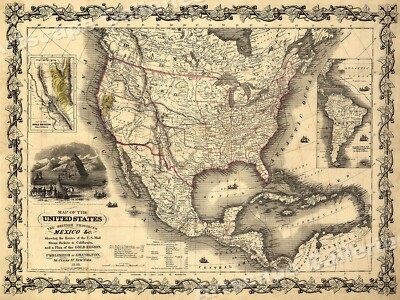
Genuine Antique map of the United States, Gold Region of Calif. by Mitchell 1852
Genuine. Antique map of the United States of America from Augustus Mitchell's School and Family Geography, 1852. This interesting steel plate engraving has original hand coloring and shows the states and territories as they existed in the mid-1800s. Many Indian tribes are named, routes to Oregon and California are shown, and rivers, canals, railroads and mountain ranges are identified. Population of larger cities is shown(for instance New York City has 516,000 people) An inset shows the Gold Region of California. Map exhibits age toning with some staining on lower right that does not affect image, and minor tears in margin. Center fold as issued with small separation in lower fold. Image measures 10 1/2"x 16 3/4" NOT A REPRODUCTION. All of our items are genuine antiques as described. RcmdId ViewItemDescV4,RlogId p4%60bo7%60jtb9%3Fuk.rp*3A%3Cd%3Ff6%3E-13cd83de76e-0xf8-
|
|
|
1850 Map of North Carolina with Gold Region - Published by Thomas Cowperthwait
1850 Map of North Carolina with Gold Region- Published by Thomas Cowperthwait and Co. Shrink Wrapped With Mat and Backing This hand colored map is an original copper plate engraving. Dating to 1850 by the legendary American Mapmaker S.A. Mitchell, the elder. It represents the state of North Carolina. This historically important map is extremely rare as it existed only in the 1850 edition of the Mitchell’s Universal Atlas. Also of historic importance is the fascinating inset of the North Carolina Gold region and Profile of the Dismal Swamp. Of interest included with this antique map are its canals, roads& distances from place to place along the stage& steam boat routes. ~ MEASURE ~ 16" x 20" including mat which fits a standard size frame. Maps were matted and shrink wrapped when I purchased them. Shrink wrap may have some ... moresticker glue and other imperfections, mat board should be clean and free of defects other than along the edges that would be covered when framed. Powered by The free listing tool. List your items fast and easy and manage your active items.
|
|
|
1849 United States & California Gold Region Map - 24x32
United States and British Provinces- 1849 Size: 24" x 32" 61 cm x 81 cm) x Also Available in 18" x 24" from our eBay Store This is a great Classic Map originally published circa 1849. This Map shows the United States California's gold region and popular western trails as they were in 1849. This poster. Which evokes the vivid images of a simpler time, is a custom reproduction printed on 68lb Heavyweight Enhanced Matte Art Paper. This Historic Art Print is suitable for framing. Mounting or direct display on any wall! 000 Artscape Galleries/ Posters Past More Prints and Posters Available from our eBay Store! Shipping price includes delivery confirmation. We combine shipping for multiple purchases- add $1.00 for each additional poster. All posters are professionally packaged to ensure that they arrive safely and undamaged: ... moreYour poster is first rolled and inserted into a plastic sleeve before being placed into a Heavy-Duty mailing tube for delivery. We stand behind the quality of every poster. If you are not satisfied with your purchase. Please contact us within 30 days to arrange for either an exchange or a full refund. gsrx_vers_468(GS 6.4(468)
|
|
|
Alaska & Yukon region c.1899 w/ Klondike Gold Region
Alaska& Yukon region c.1899 w/ Klondike Gold Region Alaska and Klondike Gold Region Attractive original antique color lithographed map of Alaska. Showing the Klondike Gold regions. With nice detail and attractive coloring. Issued Buffalo. NY, c. 1899 by Matthews- Northrup Co. Sheet size c. 8" W x 9" H. Map image area c. 7 1/2" W x 7 1/2" H. Original fold line as issued. In VG to VG+ condition. Mostly clean, attractive and worthy of display. If it arrives and you are not happy. We'll take it back without any hassle. 70] Any defects along the sheet edges and in the margins may be seen in the photos. note: All old sheets of printed paper possibly have short edge splits. Each sheet has existed for a very long time and has probably been handled repeatedly in the course of it's existence. It has a history unique ... moreto it as an object. Most of the time any edge splits are short. Minor, insignificant and have been closed- either long ago or more recently with small pieces of archival tape. Most often these splits are trivial and easy to overlook visually. Basically, they would not significantly affect the piece adversely. The item is offered as seen. Please look carefully and make your decision knowing this antique image is nice. But it is not in perfect"like new" condition. However, with whatever flaws it possesses, it remains entirely worthy of ownership and inclusion in any related collection. We feel it will prove very pleasing to its new owner. We stand behind everything we sell. Everything we offer is guaranteed to be an authentic original antique item as described. We do not sell modern reproductions. Please visit our. We happily accept PayPal! WE OFFER FLAT RATE SHIPPING WORLD WIDE! Please request an invoice before paying for multiple items so that we can ensure that you are not overcharged for shipping! To receive our flat rate shipping rates you must request or wait for an invoice. We can no longer refund e
|
|
|
RARE KLONDIKE GOLD REGION ALASKA HAND-COLORED DOUBLE PAGE MAP
TITLE MAP OF THE KLONDIKE REGION ON THE UPPER YUKON ALASKA AND KLONDIKE REGION ISSUED BY J. MARTIN MILLER DATED 1899 THIS AUCTION IS FOR AN ORIGINAL MAP OF ALASKA SHOWING THE KLONDIKE GOLD REGIONS. MAP IS VERY DETAILED SHOWING MANY TOWNSHIPS. VILLAGES AND ALL WATERWAYS. FERRY ROUTES AND PROPOSED RAILROADS ARE ALSO SHOWN. MAP MEASURES 16 x 20 INCHES FAIR-GOOD CONDITION CENTER FOLD
|
|
|
2011-12 KHL Avangard Omsk Region #АВГ001 Alexei Kalyuzhny GOLD
You are bidding on 2011-12 KHL Avangard Omsk Region#АВГ001 Alexei Kalyuzhny GOLD SHIPPING AND HANDLING(Worldwide) $3.50 + $0.25 for every additional card Payment must be received within 7 days If you win multiple items. Please wait until I send an invoice with combined shipping If you wish to combine items that are one week apart. You must contact me within 7 days after the end of your first auction If I don't receive a payment or you haven't contacted me within 7 days after the auction end I will open an unreceived payment case on eBay I accept returns but the buyer pays for return shipping If you have any questions. Please send a message Powered by The free listing tool. List your items fast and easy and manage your active items.
|
|
|
Alaska w/ gold region 1912 color litho map German
Alaska w/ gold region 1912 color litho map German Alaska Attractive original antique color lithographed map. Nicely detailed. With countless individual place names mentioned and all counties outlined. Klondike district is named. Goldfields overprinted in yellow and corresponding to the key at bottom below title. Issued c. 1912. Germany. Sheet size c. 6 5/8" W x 9 7/8" H. Map image area c. 5 1/2" W x 8 3/8" H. In VG to VG+ condition. Mostly clean, attractive and worthy of display. Map with some very light edge-toning. Otherwise remaining clean and quite well-preserved overall. If it arrives and you are not happy. We'll take it back without any hassle. 144] Any defects along the sheet edges and in the margins may be seen in the photos. note: All old sheets of printed paper possibly have short edge splits. Each sheet ... morehas existed for a very long time and has probably been handled repeatedly in the course of it's existence. It has a history unique to it as an object. Most of the time any edge splits are short. Minor, insignificant and have been closed- either long ago or more recently with small pieces of archival tape. Most often these splits are trivial and easy to overlook visually. Basically, they would not significantly affect the piece adversely. The item is offered as seen. Please look carefully and make your decision knowing this antique image is nice. But it is not in perfect"like new" condition. However, with whatever flaws it possesses, it remains entirely worthy of ownership and inclusion in any related collection. We feel it will prove very pleasing to its new owner. We stand behind everything we sell. Everything we offer is guaranteed to be an authentic original antique item as described. We do not sell modern reproductions. Please visit our. We happily accept PayPal! WE OFFER FLAT RATE SHIPPING WORLD WIDE! Please request an invoice before paying for multiple items so that we can ensure that you are
|
|
|
State Maps - COLORADO (CO) TERRITORY & GOLD REGION 1862 MAP
This is an exquisite full-color Reproduction printed on heavyweight(7.0 MIL) Glossy Photo Paper. These maps are perfect for framing. Or a wonderful and unique gift for family members, friends or co-workers! All Information is Carefully Compiled from Actual Surveys Original Maps are often difficult to find and usually have fold lines. Identifying stamps or markings, tears, ragged edges, and assorted other natural signs of age that detract from their beauty. All of our maps have been professionally restored to depict their original beauty, while keeping all historical data intact. These maps are fabulous pieces of history full of information useful to Historians. Genealogists, Cartographers, Relic Hunters, Others. They make fascinating conversation pieces and splendid works of art for the home or office. Map Size: 29.63 x 23 Site Specifics ... moreTo This Map Are: Original Counties of: Summit. Huerfano |n|Pueblo, El Paso, Weld, Arapahoe, Douglas, Park, Lake, Conejos, Fremont, Costilla, Home Peak, Sierre San Miguel, Elk Mountains, Wet Mountain Valley, San Luis Park, Bents Fort, Fot Garland, Bear River, Platte River, Arkansas River, and Boiling Spring. The following towns are featured: Colorado City. Greenhorn, Carnero, Kit Carson, Canon City, Spanish Bar, Jefferson, Hamilton, Fair Play, Cherry Creek, and Parkville. This Map is Situated in: Territory of Colorado. SKU: COZZ0001 and Powered By:
|
|
|
9.5 Grams Natural Gold Flakes from the Alaska Fortymile River Region
The gold pictured is the gold you will receive. The gold is off of a 6 inch dredge I used on the South Fork of the Fortymile River near Chicken Alaska. The gold is fine. Flake, and 2 small nuggets.
|
|
|
Yukon Klondike Gold Region shown Canada Beaufort Sea 1931 vintage color map
Yukon Klondike Gold Region shown Canada Beaufort Sea 1931 vintage color map Yukon Issued 1931. Indianapolis by George F. Cram Fine original antique offset color map. Printed in the early 20th century, on quality paper which retains its inherent structural flexibility and soundness. In near VG or better condition. Light minor age wear, overall very presentable and attractive[note: we grade very conservatively and always seek to disclose any noteworthy flaws] The printed area remains visually pleasing. A nice impression of an interesting antique map which will look nice when displayed. Sheet measures c. 14 3/4" H x 11 1/4" W. Printed area measures c. 14" H x 10 1/4" W. 36680] Any defects along the sheet edges and in the margins may be seen in the photos. note: All old sheets of printed paper possibly have short edge splits. ... moreEach sheet has existed for a very long time and has probably been handled repeatedly in the course of it's existence. It has a history unique to it as an object. Most of the time any edge splits are short. Minor, insignificant and have been closed- either long ago or more recently with small pieces of archival tape. Most often these splits are trivial and easy to overlook visually. Basically, they would not significantly affect the piece adversely. The item is offered as seen. Please look carefully and make your decision knowing this antique image is nice. But it is not in perfect"like new" condition. However, with whatever flaws it possesses, it remains entirely worthy of ownership and inclusion in any related collection. We feel it will prove very pleasing to its new owner. We stand behind everything we sell. Everything we offer is guaranteed to be an authentic original antique item as described. We do not sell modern reproductions. Please visit our. We happily accept PayPal! WE OFFER FLAT RATE SHIPPING WORLD WIDE! Please request an invoice before paying for multiple items so that we ca
|
|
|
GOLD RUSH MAP ALASAKA 1901 YUKON KLONDIKE REGION INSET MINING CAMPS GOLD AREAS
UP FOR AUCTION. WE OFFER THE ALASKIAN REGION 1901 A fine early vintage and genuine antique map that shows in excellent details the mining areas and the small mining camps. Inset of the Klondike region. Inset showing all of Alaska, inset of the Country between Juneau and Fort Selkirk and the small newly established mining villages and camps. Map in color. Printed vertically and measures about 13.5 x 20" never been folded, no tears or repairs, no odors. The map is expertly detailed in every way. Northwestern portion of the United States also shown in good detail. NOTE: We will gladly combine your winning items into one shipment to save you postage costs. NOTE: If there is advertising below and a web link. This is NOT US. And we do not endorse any item that is being offered in those links. We offer only genuine items. No worthless copies ... moreor reprints or reproductions. However, the movie thumb nail is indeed ours, showing other items and if any current bidding] A FRIENDLY NOTE ON SHIPPING Please note that I ship items as quickly as I can. We have a packing room all set up for me. I am a bit disabled from arthritis. some days are good, some days are not so good. There are times I cannot manage to pack up the winning orders, so there may be a day or two delay. Just to inform is all, please do not use this against me on the Ebay"star" system. Many thanks, and, Many thanks for the bidding. OVERSEAS SHIPPING INFORMATION For those overseas. Please note that the shipping fees vary depending on the item. We will NOT ship to any country in the Middle East but for Israel. Nor to Africa, nor to Mexico unless you have an address in the states. We have no choice due to the high losses sustained. Sorry. Powered by The free listing tool. List your items fast and easy and manage your active items. ag14.RcmdId ViewItemDescV4,RlogId p4%60bo7%60jtb9%3Fuk.rp*bd%3Eag14-13db074b4f7-0xfc-
|
|
|
Made For You Greenville Region GOLD LEVEL McDonald's Pin
Up for bids: Made For You Greenville Region GOLD LEVEL McDonald's Pin. Great Condition! FAST SHIPPING! Be sure to check out all my other McDonald's Pins! I will be posting hundreds more in the next couple of weeks so please stay tuned you won't be disappointed. Thank you for checking out my items and please visit again soon. =)
|
|
|
Xbox Live 3 Months Gold Membership Subscription All Region
Xbox 360 Live 3 months MEMBERSHIP( code will work anywhere in the world) Xbox LIVE® is the online subscription for your Xbox 360®. Play Kinect™ and controller games online with friends wherever they are. Watch thousands of HD movies and TV shows instantly from Netflix. Watch any current season episode of dozens of popular TV shows with Hulu Plus. Watch live and on-demand HD sports from ESPN on Xbox LIVE. Chat with friends face-to-face on your TV with Video Kinect. Keep in touch with friends with Facebook and Twitter. Right on your TV. Listen to unlimited songs with Zune® Music Pass. Please read before purchase Description: 3 Month Xbox LIVE Gold subscription Great value for renewing your Xbox LIVE membership Your ticket to multiplayer gaming Go for the Gold and enter the online multiplayer gaming arena. With this Xbox 360 Live ... moreGold Card you'll get three months access to Xbox Live. The place where gaming, entertainment, and competition converge. With features like intelligent matchmaking, leagues, ladders and tournaments, you'll have an incredible online gaming experience. With your subscription you'll get your own Gamer Card, Gamer Picture, motto, and more. Best of all, you can renew at your pace, without charges to your credit card. 1) Redeem your code from your PC Sign in to your Xbox LIVE account. Press the silver/green Xbox Guide Button on the controller Navigate to Marketplace tab. Select Redeem Code& enter code. 2) Redeem yor code from your XBOX 360 Sign in to your Xbox LIVE account. Press the silver/green Xbox Guide Button on the controller Navigate to Marketplace tab. Select Redeem Code& enter code. Payment: Only verified Paypal payment will be accepted Shipping: Fastest shipping available Regu lar letter mail Standard Shipping No buyers with positive feedback less than 5 or accounts which have started in less than 1 month ago. I have reserved my right to cancel your purchase if I find suspicious If you have any questions feel free to contact me. And I will try to get ba
|
|
|
1885 UNITED STATES Map MITCHELL ATLAS CALIFORNIA GOLD REGION Odd Western Terr
An ORIGINAL antique map of the UNITED STATES from Mitchell's New Intermediate Geography Atlas dated 1885. The States and Territories are individually hand watercolored. North and South dakota are shown still combined as a large DAKOTA TERRITORY. Oklahoma is labeled the INDIAN TERRITORY. A number of areas in California. Idaho, Nevada, Colorado, and Arizona are marked GOLD REGION or SILVER REGION. The original TRANSCONTINENTAL RAILROAD completed in 1869 is shown crossing the west and now a second railroad, the Northern Pacific is shown from Duluth, MN to Portland, OR. Lake Tahoe was known as Lake Bigler at the time. The map measures 11 1/2 by 18 inches and is in excellent condition except for a 2 inch separation at the bottom end of the page fold line. There is no loss of paper. This ORIGINAL antique map is guaranteed over 125 years old. ... moreI do not sell reproductions. Just honest maps at honest prices. Discounted shipping too. Because of the insane increase in international shipping charges I now ship ONLY to U.S. addresses. NO exceptions. All items shipped within 2 business days after payment. If you have not received an item in a reasonable amount of time please email me. It has been delayed by the Post Office. I also accept returns on ANY item for ANY reason, please email me I am very easy to work with. Feedback is not the same thing as an email, please email first. On Oct-19-07 at 13:06:06 PDT. Seller added the following information:
|
|
|
Boy Scouts BSA Boy Scouts of Canada BSC Fredericton Region Gold Rush 1968 Patch
Up for auction is a BSA Boy Scouts of Canada BSC Fredericton Region Gold Rush 1968 patch.
|
|
|
2 German North Rhine Westfalia Region Police Hat Badge Insignia Silver And Gold
2 German North Rhine Westfalia region Police Officers Cap Badge Very collectable German Police Service historical memorabilia. Badges concur with all eBay listing requirements! Posted with
|
|
|
Xbox Live 3 Months Gold Membership Subscription ( 3 X 1 Month Gold) All Region
Xbox 360 Live Three 1 month(3 X 1 M onth GOLD MEMBERSHIP) code will work anywhere in the world) Xbox LIVE® is the online subscription for your Xbox 360®. Play Kinect™ and controller games online with friends wherever they are. Watch thousands of HD movies and TV shows instantly from Netflix. Watch any current season episode of dozens of popular TV shows with Hulu Plus. Watch live and on-demand HD sports from ESPN on Xbox LIVE. Chat with friends face-to-face on your TV with Video Kinect. Keep in touch with friends with Facebook and Twitter. Right on your TV. Listen to unlimited songs with Zune® Music Pass. Please read before purchase Description: Three 1 Month Xbox LIVE Gold subscription Great value for renewing your Xbox LIVE membership Your ticket to multiplayer gaming Go for the Gold and enter the online multiplayer gaming ... morearena. With this Xbox 360 Live Gold Card you'll get 3*1 month access to Xbox Live. The place where gaming, entertainment, and competition converge. With features like intelligent matchmaking, leagues, ladders and tournaments, you'll have an incredible online gaming experience. With your subscription you'll get your own Gamer Card, Gamer Picture, motto, and more. Best of all, you can renew at your pace, without charges to your credit card. 1) Redeem your code from your PC Sign in to your Xbox LIVE account. Press the silver/green Xbox Guide Button on the controller Navigate to Marketplace tab. Select Redeem Code& enter code. 2) Redeem yor code from your XBOX 360 Sign in to your Xbox LIVE account. Press the silver/green Xbox Guide Button on the controller Navigate to Marketplace tab. Select Redeem Code& enter code. Payment: Only verified Paypal payment will be accepted!Fast L ightning Delivery! No buyers with positive feedback less than 5 or accounts which have started in less than 1 month ago. I have reserved my right to cancel your purchase If you have any questions feel free to contact me. And I will try to get back to your as soon as I can Thank you!
|
|
|
XBOX LIVE GOLD 3 MONTH WORLDWIDE CODE FREE REGION UNIVERSAL
SELLS MEMBERSHIP CODE XBOX LIVE GOLD 3 MONTH UNIVERSAL CODE FREE REGION THIS CODE IS USED ON ANY ACCOUNT IN WORLD CODE WILL BE SEND BY MAIL EBAY WITHIN 24 HOURS THE CODE IS A 3X 1 MONTH THE RETURN ON THIS PRODUCT WILL BE DENIED BECAUSE SINGLE USE IF YOU HAVE ANY QUESTION PLEASE CONTACT US o.RcmdId ViewItemDescV4,RlogId p4%60bo7%60jtb9%3Fuk%601d72f%2Bhpl%7E3go7%3Eo-13e514e637a-0xf5-
|
|
|
xbox live gold 12 month FREE REGION worldwide
SELLS MEMBERSHIP CODE XBOX LIVE GOLD 12 MONTH UNIVERSAL CODE FREE REGION THIS CODE IS USED ON ANY ACCOUNT IN WORLD CODE WILL BE SEND BY MAIL EBAY WITHIN 24 HOURS THE RETURN ON THIS PRODUCT WILL BE DENIED BECAUSE SINGLE USE IF YOU HAVE ANY QUESTION PLEASE CONTACT US
|
|
|
XBOX LIVE GOLD 12 MONTH CODE WORLDWIDE REGION FREE
VEND ABONNEMENT XBOX LIVE 12 MOIS CODE UNIVERSEL ENVOIE DU CODE PAR LA MESSAGERIE EBAY ENVOIE SOUS 24 HEURES SELLS MEMBERSHIP CODE XBOX LIVE GOLD 3 MONTH UNIVERSAL CODE FREE REGION THIS CODE IS USED ON ANY ACCOUNT IN WORLD CODE WILL BE SEND BY MAIL EBAY WITHIN 24 HOURS LE RETOUR SUR CE PRODUIT EST REFUSE CAR USAGE UNIQUE SI VOUS AVEZ DES QUESTION MERCI DE NOUS CONTACTER THE RETURN ON THIS PRODUCT WILL BE DENIED BECAUSE SINGLE USE IF YOU HAVE ANY QUESTION PLEASE CONTACT
|
|
|
Gold Tone & Enamel BPOE Elks # 876 Laconia NH LAKES REGION PLAYGROUND lapel pin
Gold Tone& Enamel BPOE Elks# 876 Laconia NH LAKES REGION PLAYGROUND lapel pin. Measures about 1" x 1" in Excellent Like New condition.
|
|
|
UAW REGION 9 Enameled Gold Lapel PIN
5/8 X 1/2 inches-GOLD PLATED-VERY GOOD CONDITION-FROM A LOCAL TRENTON. NJ ESTATE-THANKS FOR LOOKING Powered by The free listing tool. List your items fast and easy and manage your active items.
|
|
|
BSA Mug Top of the World Mt. Everest Western Region - gold trim rim
BSA Mug Top of the World Mt. Everest Western Region- gold trim rim A Collectible Historical Scouting Memorabilia Item for Display Item Description: Good Condition Gold Trim Rim- some of the trim has worn off"USA" on bottom Mug Text: WR BSA TOP OF THE WORLD MY NAME IS THERE MT. EVEREST 29028 ft. ORANGE COUNTY COUNCIL Pictures are unique of the actual item available in this listing. Please review these pictures in addition to the text description and title text to see if it satisfy your collection needs. International Buyers Please Note: Customs/ Import duties. Taxes, and charges are not included in the item price or shipping charges. These charges are the buyers responsibility. Please check with your country's customs office to determine what these additional costs will be prior to bidding/buying. In some situations some items ... moreare not allowed to be sent to your country because of the buyers import laws. Buyers please check that an item is allowed to be sent to your country. These charges are normally collected by the shipping delivering freight company or when you pick the item up. Do not confuse them for additional shipping charges from me. The amount reported to Customs for merchandise value is the amount of the items plus the amount of shipping. We do not mark merchandise values below value or mark items as" gift" US and International government regulations prohibit such behavior. This Item Qualifies for the Free Additional Shipping Discount if you are in the USA and pay for all of your items together! Details about our 5 star service(click the stars) SPECIAL MUG/ CUP SHIPPING All mugs include shipping insurance at no additional cost! You must pay for all mugs together in one payment transaction. Items can be combined up to 10 days from the first item. Mug shipping discount. You pay the base fee and all other mugs paid for at the same time are shipped for free! This applies to Standard Shipping only. Other Scout related items can be combined with mugs for shipping discount. Discount onl
|
|
|
SONY DVP-S725D DVD CD Video CD VCD Player Multi Region Audiophile Gold Plated
SD/JD/sus/11144/004/100(Stuff U Sell auction tracking code) SONY DVP-S725D DVD CD Video CD VCD Player Multi Region Audiophile Gold Plated ITEM DESCRIPTION Reason for sale: Seller is having a clear out and no longer requires the item. Features: Brand: Sony Model Number: DVP-S725D Item: DVD/ CD/ Video CD/ VCD Player Multi Region Player Audiophile Boxed: No Colour: Black Functions& Features: Product Features: DVD Type: DVD Player; Number of Discs: 1; Playable Disk Types: CD(Audio) DVD Video, VCD; Video Output System: NTSC, PAL; Surround Sound: Built-In DTS Decoder, Built-In Dolby Digital Decoder; Audio S/N Ratio: 110 dB; Dynamic Range: 100 dB(DVD) 98 dB(Audio CD) Audio DAC: 24 bit/ 96 kHz; Depth: 12.01 in. Height: 3.74 in. Width: 16.93 in. Weight: 8.82 lb. Electrical Ratings: 240V Cabling Included: Attached UK 3 Pin Plug Condition: Item ... moreis in good working and cosmetic condition. There are a few light scratches and marks from previous usage. Please review the photos above for more details. Age: Unknown, Dimensions: 43cm(w) x 28cm(d) x 8cm(h) Weight: 4.1Kg. Comments: Sold as photographed. Our photographs are taken immediately prior to the auction commencing. If you have any questions about this item please contact us and we will answer promptly. MORE USEFUL INFORMATION Postage& Packing Returns& Refunds We are offering free UK P&P on this item. You can pay to upgrade this to a next working-day service. 1. Dispatch time. We pack and dispatch all items within two business days of receiving cleared payment. We often send items same-day. We will send you an email when your item is dispatched. 2. Delivery time. Free shipping will use a standard service which may take several days to arrive. For urgent deliveries. You can upgrade to a next working-day courier for £2.50. We prioritise upgraded items for dispatch. 3. Loss or damage. We use professional packing materials and comply with courier packing guidelines to minimise the chance of damage. We also retain proof of posting for our items. If you h
|
|
|
Texas California 1852 Grassl w/ Gold Region + Apacheria fine antique map
Vereinigte Staaten von Nord-America: Californien. Texas un die Terrotorien New Mexico u. Utah Nach den neuesten Hulfsmiteln gezeich. California/ Texas/ Mexico/ etc. Issued Hildburghausen. Germany, 1852 by Meyer, cartography by J. Grassl. Wonderful mid 19th century German issued engraved map. With original hand color. Rare fleeting cartographic appearance of the possible Territorial name"Apacheria" in the area below 35' latitude and north of Mexico. A remarkable close-up rendering of the American southwest at this date. Including a prominent" Gold Region" in California. In the Great Basin area. A mythical transverse mountain range cuts across the"Great Sandy Plain" Mormon City is boldly labelled at the bottom of the Great Salt Lake, Fremonts 1845 route is shown, several short mysterious river segments are ... moreshown, many Indian tribes(including"long beards" Texas without its northern pan handle, Austins Grant" outlined, etc. In good+. Mostly clean condition. Margins toned, small light spotting along left hand side(in Pacific Ocean) tiny worm hole backed near Salt Lake and essentially invisible to the eye. Otherwise map remains clean and well-preserved. A very pleasing and wonderful map. Sheet measures c. 12" W x 10" H. Printed area measures c. 11 1/8" W x 8 7/8" H. Wheat. Mapping Trans-Mississippi West. 750(calling it a"beautiful map" Wheat. Maps of California Gold Region. 217. Espenhorst. Andree. Steiler, Meyer& Co. 3.1.2.1(noting several printings of the Zeitungs-Atlas, but with uncertainty about them) Francaviglia. Mapping and Imagination in the Great Basin. Fig. 5.9& detail. PBA Gallery. Ernst Gerber Collection 2003, Sale 273, item#166. Richard Fitch Maps- Catalogue#56- item 468. R458. Guaranteed Authentic! We do not sell modern reproductions. Condition All of our items are original antique pieces and it is important to keep in mind that many of them have been around for 100 years or more. Individual pieces may have seen many ow
|
|
|
North Carolina showing gold region 1846 Mitchell Dismal Swamp fine antique map
A New Map of North Carolina With its Canals. Roads& Distances from place to place along the Stage& Steam Boat Routes. Issued 1846[1848] Phila.by Samuel Augustus Mitchell. Fine mid-19th century lithographed American state map with attractive original hand color. Includes an inset of the"gold region" of the state at bottom left. Inset of Neuse River and Newbern harbor area at top left, three column Table of Distances beside it. Paper evenly and moderately toned as typical. Light minor scattered foxing along edges and in blank margins, otherwise clean and attractive. Sheet Measures c.16 3/4" W x 13 3/4" H. Engraved area measures c. 13 3/4" W x 11 1/2" H. Folio. A lovely map for display. Tooleys Dictionary of Mapmakers. Vol. 3, pp. 260-1. R696. Guaranteed Authentic! We do not sell modern reproductions. Condition ... moreAll of our items are original antique pieces and it is important to keep in mind that many of them have been around for 100 years or more. Individual pieces may have seen many owners and been handled many times over the course of their existence and as a result each piece has developed a history of it's own. Short edge splits(often repaired with archival tape) Foxing, discoloration, etc. are all things to expect on items of this type. They rarely distract from the piece and often add to the overall character of the item. Keep in mind when you receive your item that you are not handling a modern copy, you are holding a piece of history, an item that has been around for a very long time and will, with proper care, be around for a long time to come. We try to note any significant flaws in the description, but less noticeable or common characteristics may not be mentioned. As we are a US based company all of our measurements are in Inches. If you need the size in Centimeters please multiply the supplied measurement by 2.53. Payment and Shipping We happily accept PayPal! Payment is appreciated within 5 days of invoicing. Once payment has been received we do our best to mak
|
|
|
1850 North Carolina Framed Map Pre Civil War Charlotte Gold Mining Region EX NR!
Here's one of two North Carolina Pre-Civil War maps that have matching frames that we are currently listing. This one was printed by the famous Philadelphia. Pennsylvania engraver and mapmaker Thomas Cowperthwait and is marked to be registered in 1850. It is titled A New Map of NTH Carolina with it's Canals, Roads and Distances from Place to Place, along the Stage and Steam Boat routes. At this point in history and particularly in the wilderness of the Carolinas, the best mode of transportation was the waterways with the railroad being new. This one has a box dedicated to the gold mining region showing the now major city of Charlotte in it's infancy. It runs from the Great Catawba River to Wadesboro and the Little River. Another box shows depth levels with tidal information and is titled Profile of Dismal Swamp Canal(mosquito ... morerepellant was not invented in the yet) A third box shows the Craven area of the Neuse river. The map reads to be published by TC& Co No 253 Market St, Philadelphia. Another interesting aspect is the longitude lines are showing East and West of Washington not the standard Greenwich. The map measures 13" by 15-1/2" to the outside of the decorative border. The frame is made of wood and has a bluish green or greenish blue color over gold. It has a slight washed look to make it look antiqued but I Don't know the age of the frame, it could be arts and crafts. These maps were the standard of the time period before the Civil War when plantations where still thriving and the political atmosphere of the country was changing. The maps. Even for the south and southern states would have been manufactured and printed in the north due to the better technology and industry of the time. These maps would look great in an office for a surveyor, government official, historian, or history professor or teacher for a school or college. Need something authentic for your Civil War Re enactment. Reenactment groups have a chance here to show people on an authentic map how the soldiers fou
|
|
|
Mexico California Gold Region Texas c.1852 antique Hall hand color map
Mexico. California& Texas Issued c.1852. Edinburgh by A. C. Black& S. hall Fine original antique engraved map. With original hand color. Wonderful map which shows the newly discovered gold region in California in yellow. Printed on quality paper which retains its inherent structural flexibility and soundness. In near VG or better condition. Mostly clean and attractive, minor light surface age wear[note: we grade very conservatively and always seek to disclose any noteworthy flaws] The printed area remains visually pleasing. A nice impression of an interesting antique map. Any minor defects along the sheet edges and in the margins may be seen in the photos. Sheet measures c. 16 1/4" W x 11 5/8" H. Engraved area measures c. 14 5/8" W x 10 1/8" H. 42024] Guaranteed Authentic! We do not sell modern reproductions. Condition ... moreAll of our items are original antique pieces and it is important to keep in mind that many of them have been around for 100 years or more. Individual pieces may have seen many owners and been handled many times over the course of their existence and as a result each piece has developed a history of it's own. Short edge splits(often repaired with archival tape) Foxing, discoloration, etc. are all things to expect on items of this type. They rarely distract from the piece and often add to the overall character of the item. Keep in mind when you receive your item that you are not handling a modern copy, you are holding a piece of history, an item that has been around for a very long time and will, with proper care, be around for a long time to come. We try to note any significant flaws in the description, but less noticeable or common characteristics may not be mentioned. As we are a US based company all of our measurements are in Inches. If you need the size in Centimeters please multiply the supplied measurement by 2.53. Payment and Shipping We happily accept PayPal! Payment is appreciated within 5 days of invoicing. Once payment has been received we do our best to ma
|
|
|
1849 CALIFORNIA GOLD REGION VIA CAPE HORN WALL MAP
History-Image Photo. Map& Poster Archive Search in titles& descriptions Browse Photographs by Category Historic Posters Historic Maps Shipping& Payment We combine shipping so you only pay one shipping charge regardless of how many items you purchase U.S. $ 5.95 Canada $ 7.50 International $ 10.00 You will receive an email at the close of auction. Click on the payment link to complete payment. We accept Paypal. You can also pay for your purchase over the phone with a credit card: 503) 408-2360 See our Framing work work Who are you buying from? This is a beautifully detailed California gold region map showing both the state and the route around cape Horn. 1849. From map: Map of the Gold Regions of California. Showing the Routes via Chagres and Panama, Cape Horn, c. 1849. Actual map is much sharper and detailed than the low resolution ... morescanned image used here. Map measures approximately 18" by 24" 46 by 61cm) The map is a modern reprint. It is reprinted(a modern reprint) using premium semi-matte. Japanese paper and Ultrachrome ink, which has an archival rating of 125+ years. For more information about how the maps are made see our Custom Framing& Matting Options We offer a variety of sizes and options for framing your purchase. to see frames and prices Example of map detail: Frequently Asked Questions Is the resolution disappointing? No. Is the simple answer. Because we are dealing with historical pieces from a wide range of regions, creators and time periods, there is variation in the quality. However, we always ask ourselves if we would be pleased with a particular image framed and on display before we add it to our inventory. We do not carry low-quality"snapshots, cheap digital scans or multi-generational prints. When we create a large-format negative at the archive the resulting digital file can easily exceed one gigabyte. The detail is so good that the actual fibers in the paper or cloth of the original map are visible in the print we make. Are the maps in the public domain? Many o
|
|
|
Rarität 10 + 100 Yuan Gold, Silber Set CHINA 2008 Ningxia Hui Autonomous Region
Ihr bietet hier auf Münzenset 10 und 100 Yuan Gold/Silbermünzen China 2008 in PP 50. Jahre Autonome Region Ningxia Hui Nominalwert: 10 und 100 Yuan Durchmesser: 40.00 und 22,00 mm Dicke: 4.06 und 1,92 mm Gewicht: 31.31 1 Oz und 7,74 1/4 oz Gramm Metall: 999/100 Silber und 999/1000 Gold Auflage: nur 20. 000 und 10.000 Stück weltweit als Set nur 5. 000 Ex Rand: Gekerbt Erhaltungsgrad: Polierte Platte bankfrisch, absolutes Sammlerstück Krause-Mishler Catalogue number, Nummer: KM# 1856 und KM# 1857 Lieferung: Münzen im Münzkapseln. Box und Zertifikaten Schauen Sie auch meine anderen Artikel an. Münzekatalog online. Hier klicken: 10 and 100 yuan silver and gold proof coin set. China 2008 The 50th Anniversary of the Founding of Ningxia Hui Autonomous Region Denomination: 10 and 100 yuan Diameter: 40.00 and 22,00 ... moremm Thickness: 4.08 and 1,92 mm Weight: 31.31 gram/ 1 Oz und 7,74 gram 1/4 oz Composition: 999 Silver and.999 Gold Issue limited: max 20, 000 and 10, 000 Stück as Coin Set max 5. 000 worldwide Quality: proof. New Krause-Mishler Catalogue number: KM# 1856 and KM# 1857 Delivery: Coins in Original-Box and COA Look at my other items Sehr selten/ Very rare! Viel Spaß beim Bieten! Happy bidding! Privatverkauf. Keine Garantie. Keine Rücknahme.
|
|
|
1857 Desilver Map United States California Gold Region Nebraska Oregon Territory
Lake Erie Maps& Prints An Original Antique Map: Not a Modern Reproduction! We are Happy to Combine Multiple Purchases to Save on Shipping! Free US Shipping on purchases of 5 or more maps. Description: It is an authentic Antique Map: Not a modern reproduction! It is a steel plate engraved map with original handcoloring and a centerfold as issued. The most sought after of all the Mitchell Maps. It is from a rare edition of Charles Desilver's New Universal Atlas. Published by Desliver in Philadelphia in 1857. The map has a copyright date by Desliver of 1856 in small print in the bottom margin. Desilver's name and address 251 Market St. Philladelphia appears under the title area. The American Cartographer, Charles Desilver, bought the copyrights and plates of Mitchell's atlas of the same name and updated the maps and made some ... moreminor changes particularly in the title block, added his own border style, choices of color and published the atlas from 1856 to 1859. The run of the Desilver atlas was more limited in number than the previous Cowperthwait publishing, thus the Desilver maps are the rarest of all the Mitchell maps published and difficult to find. A copy of the title page is included. Overall, a nicely preserved map with nice color that show early territorial borders including Minnesota, Nebraska, Washington, Oregon, Utah, New Mexico, a long Kansas, Oklahoma as Indian Territory and insets of the California Gold Region and Washington DC. Size: The map image measures approximately 16 by 26 1/4 inches on a 17 1/2 by 27" page. Condition: The map is in Good to Very Good condition for its age with overall tonal aging and original handcoloring and centerfold as issued. Blank on the reverse, printed on a strong flexible page, not brittle, basically as seen in the pics. The bottom 5 inches of the centerfold has been professionally repaired with archival materials on reverse, There is some darkening along the edges, margin stains, some very minor light foxing hardly worth mentioning a few random light
|
|
|
Boy Scout Old Region 7 Seven Charm w/portion of gold colored chain
Charm is mint condition. Old Region 7 Charm w/portion of gold colored chain. Check out my! ``d.RcmdId ViewItemDescV4,RlogId p4%60bo7%60jtb9%3Fvo%7B%3Dd70f%2B%3E%60%60d-13f7e7d1c5b-0xfd-
|
|
|
Discounted World Of Tanks WOT SEA Region 800 Gold.
This is a one time 800 gold credit for SEA accounts only! You are only able to use this deal ONCE per account. You will receive a code via eBay message once your payment is confirmed. There will be NO physical item shipped! Please allow up to 24 hrs delivery time after payment confirmation. Expiration date: 12/31/2013 Posted with Posted with
|
|
|
Vintage Russian Handpainted Lacquer Gold Leaf Box Kholuy Xonya Region W Paper Wk
Vintage circa 1973 black lacquer handpainted Russian box. The box has gold leaf with an egg based tempera painting of Repunzel and a squirrel. This beautiful piece of art is from the Kholuy(Kholui) village region. A certificate written in Russian is included. There are written letters at the bottom of the lid. The box measures about 5 1/2" long x 3 3/4" wide x 2" high. The box is in very good used vintage condition. No chips or cracks were found. There are normal signs of use and age wear. A very detailed and collectible piece offered at a good value. Powered by The free listing tool. List your items fast and easy and manage your active items. On Jun-30-13 at 17:43:42 PDT. Seller added the following information: Every buyer gets a MyStoreRewards invitation for cash back 260.RcmdId ViewItemDescV4,RlogId p4%60bo7%60jtb9%3Fvo%7B%3Dd70f%2B%3E260-13f9f32ac4b-0x101-
|
|
|
Gold Region Black Hills General Custer Expedition 1874 antique wood engraved map
The Gold Regions of the Black Hills. Explored by General Custer's Expeditions Issued. August 22, 1874 by Harpers Weekly Fine original antique wood engraving. Printed in the mid 19th century. On quality paper which retains its inherent structural flexibility and soundness. In Good+ to near VG or better condition. Overall very clean, paper is lightly uniformly age toned as typical with some faint scattered age spotting or small minor soiling, but the image remains entirely presentable and attractive[note: we grade very conservatively and always seek to disclose any noteworthy flaws] Text on verso as issued. The printed area remains visually pleasing. A nice impression of an interesting image. Any minor defects along the sheet edges and in the margins may be seen in the photo. Harpers Weekly was one of the most popular news periodicals of ... moreits day and was profusely illustrated with charming and well executed wood engraved images created exclusively for it. These images now appear quaint and delightfully dated to our eye. With a somewhat folk art appeal to them. Harpers employed many talented artists and many of their images are worthy of framing for display. Sheet measures c. 10" W x 7 3/4" H. Engraved area measures c. 8 3/4" W x 6 5/8" H[44651] Guaranteed Authentic! We do not sell modern reproductions. Condition All of our items are original antique pieces and it is important to keep in mind that many of them have been around for 100 years or more. Individual pieces may have seen many owners and been handled many times over the course of their existence and as a result each piece has developed a history of it's own. Short edge splits(often repaired with archival tape) Foxing, discoloration, etc. are all things to expect on items of this type. They rarely distract from the piece and often add to the overall character of the item. Keep in mind when you receive your item that you are not handling a modern copy, you are holding a piece of history, an item that has been around for a very long
|
|
|
German Polizei Baben Wurttemburg Region Police Uniform Rank Insignia 1 Gold Star
German Polizei Baben Wurttemburg Region Police Uniform Rank Insignia X1 1 Gold Star Very collectable German Police Service historical memorabilia Postage UK £1.00 2nd Class Worldwide £2.00 See photos for Condition I PROVIDE A FREE SELLING SERVICE ON EBAY FOR ANY COLLECTIONS OF POLICE MEMORABILIA. I HAVE 1000's OF COLLECTORS WORLDWIDE WHO COLLECT FOR THIS NICHE HOBBY IF YOU WOULD BE INTERESTED IN THIS SERVICE PLEASE DROP ME AN EMAIL. SEE ADDITION INSTRUCTIONS) If you would like to be added to my FREE newsletter subscription with loads of information on 1000's of Police and law Enforcement memorabilia Collectables to be listed GO TO MY ABOUT ME PAGE( Above next to my feedback score) CLICK on the FREE Police Collectors Newsletter link fill out details on page and that's it. Also on the ABOUT ME page is My entire itinary ... moreof items in photographic form and also my Police Collectors Blog( Favourite Links) If while you are browsing my items listed on Ebay there is nothing you can see your interested in. If you check out my other items to be listed there maybe something you are after to be listed and you will have prior notice of whats on offer Please DO NOT leave Negative feedback if you have an issue then email me( Additional Information Box) and i will get it sorted. If you do not communicate with me then i cannot assist You. Thankyou for your visit and please favourite my store and hope to see you again regards Richard Powered by foxrate.seller.widget.tag.foxrate.swf. RcmdId ViewItemDescV4,RlogId p4%60bo7%60jtb9%3Fuk.rp73%28e013%3F%3E%3A-13fca3899c7-0xfa-
|
|
|
Vintage Boy Scout Gold Rimmed Coffee Mug With Scout Sign/Oath Region 3
Boy Scouts of America Region 3 vintage coffee mug with gold rimmed and oath sign. The bottom of the mug is stamped USA. The mug is in great condition with no chips or cracks. Posted with;1?RcmdId ViewItemDescV4,RlogId p4%60bo7%60jtb9%3Feog4d72f%2B%3E%3B1%3F-13fd15bf64a-0xfc-
|
|
|
Pokemon Heart Gold/ Soul Silver Guide Johto Region Vol 1.
Hello! For sale is a good condition Pokemon Soul Silver/ Heart Gold strategy guide! The Guide is in good shape with very minimal wear. See pic) Pages are clean. This is Vol. 1 which covers the Johto region. Paypal only. Payment due within 24 hours of winning the auction. item will be shipped within 48 hours of receipt of cleared payment. Questions? Please ask! Check out my other items for sale!
|
|
|
1845 Map of California & Territories of Oregon & Utah, Gold Region, 13" X 15.5"
1845 Map of California& Territories of Oregon& Utah. Gold Region, 13" X 15.5" Probably printed in the early 1850's. A small tear in the upper right corner and some very light wear at the edge of the paper. An original Antique map, I sell no reproductions. Thank You!
|
|
|
1852 Grassl Map of Texas and California w/ California Gold Region and early Texa
1852 Grassl Map of Texas and California w/ California Gold Region and early Texas WE SELL ONLY ORIGINAL ANTIQUE MAPS- NOT REPRODUCTIONS Title: Vereinigte Staaten von Nord-America: Californien. Texas und die Territorien New Mexico u. Utah. Description: An appealing. Uncommon and underappreciated 1852 map of the American southwest by Jospeh Grassl and Joseph Meyer. The map covers the greater southwest from the 42nd parallel south to include all of modern day California, Utah, Nevada, Arizona, New Mexico, Texas, Colorado, and northern Mexico. Grassl presents an early configuration of this region rarely seen on maps- in fact this is the only map post-dating the Mexican American War we are aware of to depict it. The map is defined by a pre-Compromise configuration of the Territory of New Mexico, which takes center stage. Here where are seeing ... morean early bid for New Mexico statehood as a Free State filed with congress early in 1850. The bid followed the first New Mexico Constitution, approved by the State Assembly in the same year. The state, as presented in the New Mexico constitution roughly followed those borders traditionally given to the former Mexican Intendencia of Santa Fe, was to extend eastward to about 100 degrees, northwards as far as the Arkansas River, and westward to just beyond the Sierra de Mimbres, a southern extension of the Rocky Mountains. This document appeared before the U.S. Congress in the midst of a period of extraordinary contention and rivalry. First, much of the territory claimed by the first NM Constitution was also claimed by Texas- in fact, the original Texas border, terminating just east of the Sierra de Mimbres is marked on this map, but not colorized. The second issue, one of slavery, made the creation of a New Mexico state a national issue with broad ramifications- especially as it intended to enter the Union a Free State. The Compromise of 1850 forced Texas to give up(or more accurately sell) its claims along the Rio Grande as well as its northern extension thereby placing it be
|
|
|
USA 1853 South North Carolina Gold Region Florida Georgia Antique Map 60172
Title: Die Staaten von N& S Carolina Georgia& Florida, Year: 1853, Edition: 0.00, Size: 23x29cm, Condition: Very good, Publisher: Bibliographischen Instituts in Hildburghausen, Publication Loc: Hildburghausen, Pages: 1, Our Item# 60172, Original. Period map of North& South Carolina Georgia and Florida, along with inset closeups of St Augustine, the Gold Area of North Carolina, Newberne, and Charleston areas. On heavier paper in very good condition, with some hand coloring. Contact: Guarantee: Payment: According to eBay rules. We accept PayPal for payment. 6.7% sales tax will be added for all Colorado deliveries. Shipping: PLEASE NOTE: We lose money on shipping- look at the postage when you get the package. Factor in the free private insurance(instead of charging you the high postal service ins rates) And see how much you paid. ... morePlease keep this in mind when giving stars for shipping costs. International Shipping: For shipment out of the USA. Items in value over $100 are shipped registered insured, which is why the high shipping fee. Even so, we lose money on shipping- look at the postage when you get the package, factor in the free private insurance(instead of charging you the high postal service ins rates) And see how much you paid. Please keep this in mind when giving stars for shipping costs. International Buyers– Please Note: Import duties. Taxes and charges are not included in the item price or shipping charges. These charges are the buyer's responsibility. Please check with your country's customs office to determine what these additional costs will be prior to bidding/buying. We cannot mark items as'gift' We are required to put the actual value of the items won on each package. The delays and/or duties caused by this are completely out of our control and sphere of responsibility. Shipping Times: Now that eBay asks bidders to rate sellers' shipping-time. We feel compelled to point out that this judgement is supposed to be based on the time it takes us to ship the item-
|
|
|
1855 Mitchell Map United States Western Territories & California Gold Region
Lake Erie Maps& Prints! An Authentic Antique Map: Not a Modern Reproduction! See Our Ebay Store for other! Free Shipping on Purchases of 5 or More Maps and Prints Description: It is an authentic Antique map over 150 years old with original handcoloring and a centerfold as issued. It has a copyright date of 1852 by S. Augustus Mitchell in small print at the bottom. Although it is from an 1855 edition of Mitchell's School Atlas(Philadephia: Butler. 1855) A copy of the title page is included for authenticity. The map is not mounted nor matted, being sold as a single sheet as seen in the first pic. It is a nice map showing much different Western boundary configurations including Washington, Oregon, Nebraska, New Mexico, Utah, Oklahoma as large territories, and Oklahoma as Indian Territory and a nice inset of the California gold region. ... moreSize: The map image measures approximately 10 3/4 by 17 inches(27x42cm) on a 12 by 17 1/2" 31x45cm) page with a margin all around for matting as seen in the pic. Condition: It is in Good condition for its age with overall light tonal ageing and slightly faded color as seen. Some minor light browning, spoting and handling around the edges, basically as seen in the pics. The pics are of the actual map, see the pics for more on condition. Payment Details: We accept most major credit cards through Paypal and Ebay. Please ask if you have any questions about payment. International and New Bidders are welcomed and encouraged. Payment is expected within 7 days. After which Nonpaying Bidders will be reported to Ebay to recoup our listing fees. Save on Shipping: We only charge one shipping fee based on the largest map or print with multiple items shipped along with it for no extra costs. Purchase 5 or more maps or prints and receive Free First Class shipping in USA or First Class International elsewhere in the world. Although registration may be required on shipments of high value. International Customs and VAT Fees: It is the responsibility of the buyer to pay all Customs Taxes. VA
|
|
|
48hr Xbox live Gold Trial FAST DELIVERY!!! Region FREE
Very fast shipping! Code will be sent usually within 24hrs tops after payment has been received Codes will be sent via ebay message I have tested each and every code manually before selling; therefore I can guarantee a 100%working code. How to redeem code: 1. Sign in to preferred XBOX LIVE account for which the code is intended 2. Press central(Guide) button on controller. 3. Go to Marketplace and choose"Redeem Code" 4. Enter received 25 digit code and select confirmation button. 5. on next screen with confirmation choose confirm. 6. These codes are not reusable. You can only use one at a time. 7. IT IS ADVISABLE TO REDEEM THIS CODE ON YOUR XBOX 360. Rather than Xbox.com because sometimes the website has a glitch that might render the codes useless.
|
|
|
1852 Meyer Map of Texas and California w/California Gold Region and Texas at its
1852 Meyer Map of Texas and California w/California Gold Region and Texas at its Largest WE SELL ONLY ORIGINAL ANTIQUE MAPS- NOT REPRODUCTIONS Title: Vereinigte Staaten von Nord-America: Californien. Texas und die Territorien New Mexico u. Utah. Description: This is an uncommon and appealing 1852 map of the American southwest by Joseph Meyer. The map covers the greater southwest from the 42nd parallel south to include all of modern day California. Utah, Nevada, Arizona, New Mexico, Texas, Colorado, and northern Mexico. The routes of explorers as well as various emigrant routes are noted, including Fremont's Route and the Great Wagon Road(Caravanenweg der Californien-Wanderer aus dem Ostein) Salt Lake City is identified as Mormon City and is erroneously placed on the western shores of Great Salt Lake. The term'Apacheria' appears ... morein modern day Arizona, referring to the area inhabited by the Apache Indians. The map also identifies several other Indian tribes, settlements, and towns, along with various topographic features. An inset map of San Francisco is included in the lower left quadrant. This map was shortly following the Mexican American War(1846-1848) and the Treaty of Guadalupe Hidalgo. The 1848 treaty, which formally ended the war, annexed all Mexican territory north of the Gila and Rio Grande Rivers, including the short lived Republic of Texas, to the United States, increasing the country's size by about 35% Texas is here shown in a most unusual incarnation, extending north as far as the Arkansas River but terminating on the west at the 26th degree of Longitude. This map also shows the Mexico– U.S. Boundary line prior to the Gadsden Purchase. The southern border of New Mexico(and modern day Arizona) this terminates at the Gila River. Though primary intended for the construction of a transcontinental railroad along a deep southern route, the Gadsden Purchase also aimed to reconcile outstanding border issues between the US and Mexico following the Treaty of Guadalupe Hidalgo, which ended the M
|
|
|
1851 Tallis Map of Mexico, Texas (Republic) and California (Gold Region)
1851 Tallis Map of Mexico. Texas(Republic) and California(Gold Region) WE SELL ONLY ORIGINAL ANTIQUE MAPS- NOT REPRODUCTIONS Title: Mexico. California and Texas. Description: This is John Tallis’s and J.H. Rapkin's highly desirable 1851 Map of Mexico. Texas and Upper California shortly after the Mexican American War and in the early days of the California Gold Rush. Texas is depicted at its fullest extent including both Santa Fe and the Green Mountains. Upper California offers numerous interesting elements, most specifically a colored and labeled Gold Region extending along the Sacramento River as far south as an oversized Lake Tule and Santa Cruz. The'Great Caravan Route' followed by covered wagons during the Westward Expansion is also noted as it snakes its way across northern Texans and southern California to Los Angeles. The ... morevarious Intendencia of Mexico are highlighted in outline color. The map also offers several beautiful vignettes by H. Warren and J. Rogers. These attempt to illustrate Mexican life, including Mayan ruins at Uxmal(Yucatan) gold panning in California, and'Mexican Peasantry' This map appeared simultaneously in several publications including Tallis' Illustrated Atlas and Hinton's History and Topography of the United States of America. Cartographically there are no significant differences between the versions, however, the imprint on the Illustrated Atlas map reads'John Tallis and Company, London and New York; while the History and Topography example reads'John Tallis, London, Edinburgh& Dublin' Those examples published with the History and Topography, as above, also have a centerfold sometimes not present in the Illustrated Atlas edition. Tallis is considered one of the last great decorative map and atlas publishers of the 19th century. Size: Printed area measures 10 inches high by 13.5 inches wide. Condition: Very good condition. Minor wear on original centerfold. Blank on verso. Shipping: Due to recent increases in United States Postal Service rat
|
|
|
ANTIQUE 1869 CALIFORNIA GOLD REGION TEXAS KANSAS OREGON INDIAN TERRITORY MAP NR
Click Here. Double your traffic. Get Vendio Gallery- Now FREE! Very fine. Antique 1869 handcolored map, titled in fancy antique lettering, Texas, California, Oregon, Kansas and the Western Territories. Many interesting areas, such as Gold Region, Texas, Indian Territory, now Oklahoma, North and South Dakota as Dakota, and much more. Many fascianting areas, much has changed. Fine attractive period map of this area at this time. The size of the map is 7" by 9" The superb handcoloring is period to the map, this is before color printing. Rare. Winning bidder pays $3.00 shipping domestic, more foreign. Payment I accept the following forms of payment: PayPal Click to View Image Album Shipping& Handling US Shipping. $3.00 USPS First-Class Mail® International Shipping. $9.00 USPS First-Class Mail International FREE scheduling. ... moreSupersized images and templates. Get Vendio Sales Manager. FREE scheduling. Supersized images and templates. Get Vendio Sales Manager. lm3vhp.RcmdId ViewItemDescV4,RlogId p4%60bo7%60jtb9%3Fuk%601d72f%2Bjw%60%3Elm3vhp-141e5581fed-0xf4-
|
|
|
1852 RARE BEAUTIFUL MITCHELL ANTIQUE ATLAS MAP OF THE UNITED STATES-GOLD REGION
1852 RARE BEAUTIFUL MITCHELL ANTIQUE ATLAS MAP OF THE UNITED STATES-GOLD REGION, Click to View Image Album Click to View Image Album Click to View Image Album 1852 RARE BEAUTIFUL MITCHELL ANTIQUE ATLAS MAP OF THE UNITED STATES-GOLD REGION MAP BEAUTIFUL DETAILED MITCHELL ATLAS MAP FROM A HANDCOLORED HISTORIC ATLAS INCLUDES CITIES. LANDMARKS, INDUSTRY, BUSINESS AND RAILWAYS PLEASE SEE PHOTOS AS PART OF THE DESCRIPTION CONDITION: MAP IS IN GOOD CONDITION WITH NICE COLORATION SIZE: APPROXIMATELY 10" X 16" SHIPPING: U.S. FIRST CLASS RATE- $4.00. CANADA- $9.00. WORLDWIDE- $14.00 WE COMBINE SHIPPING FOR MULTIPLE WINS! THANK YOU FOR YOUR INTEREST IN OUR AUCTIONS WILL MAKE A UNIQUE GIFT FOR THE HOLIDAYS! Payment I accept the following forms of payment: PayPal Shipping& Handling $4.00 USPS First-Class Mail® Click to View Image Album ... moreClick to View Image Album Click to View Image Album Click to View Image Album FREE scheduling. Supersized images and templates. Get Vendio Sales Manager. FREE scheduling. Supersized images and templates. Get Vendio Sales Manager. Over 100.000,000 served. Get FREE counters from Vendio today!
|
|
|
1856 Desilver Mitchell Atlas Map State of North Carolina + Gold Region Rare!!
This auction is for the extremely rare and 100% original and authentic antique map of the above region. Cartographer and year. This auction is only for the map that is pictured in this listing. I cannot stress enough how beautiful this map is up close compared to the photos that you see. Note that the photos do not do the map justice. This is truly an incredible map to behold! This is your chance to own a map that can be the centerpiece of your collection. I dont say this that often but this map and the rest of the maps from this same atlas that I am listing are basically what I would call perfect/fine condition to the point where I really do not even want to sell them because these maps dont come along that often in excellent condition and these are the best ones that I have had from a Desilver/Mitchell atlas. General Description: 1. Strikingly ... moreinteresting and highly detailed map. Original hand coloring as issued. Copyright date is printed under lower border. The map depicts in great detail all of the geographical information known at the time the map was published. Note that many geographical details have changed since the map was published and were not accurate compared to today's modern maps because things were fully discovered and accurately mapped yet. Map symbols and details include individual towns. Rivers, lakes, bays, harbors, islands, mountains, forests, roads and other important places as shown on the map in this listing. 2. The map is in excellent condition considering the age and rarity of the map. The overall size of the map sheet is approximately 17 inches by 14 inches. 3. The map is a 100% original and genuine antique map. All of my maps are investment grade and collectible quality. The value of this original will only increase over time. Many people are now starting to offer cheap reproductions/copies. Why spend the money for something like that when you can have an original for a few dollars more that will only increase in value over time. Please e-mail me with any offers that you would lik
|
|
|
CALIFORNIA GOLD REGION ALONG THE AMERICAN & YUBA RIVERS Indepth! 1854 NEWSPAPER
Two Full Pages of Illustrations Showing Scenes In California-North Fork. American River, California-Parks' Bar Company Works, California-Notion Company's Works, California-Ross's Bar, California-Fine Descriptions! An Original& Complete Issue of GLEASON'S PICTORIAL dated March 25. 1854. Additional Reports Include: HON JAMES BUCHANAN AND HIS RESIDENCE-NATHANIEL BOWDITCH-CRYSTAL PALACE ILLUSTRATIONS" Check out my items!Be sure to add me to your! WOULD MAKE A WONDERFUL GIFT FOR MORE THAN TEN(10) YEARS WE HAVE PROVIDED THE COMMUNITY WITH HISTORICAL NEWSPAPERS& PERIODICALS WE HAVE WORKED HARD TO MAINTAIN A 99%PLUS FEEDBACK RATING AND STRIVE FOR A FIVE- STAR RATING AND A POSITIVE BUYING EXPERIENCE FOR ALL OF OUR CUSTOMERS* WE ASK THAT IF YOU HAVE COMMENTS OR QUESTIONS TO PLEASE CONTACT US BEFORE YOU LEAVE FEEDBACK SO ... moreTHAT WE CAN DO OUR BEST TO ACCOMODATE YOUR CONCERNS* WE CHARGE $8.00 FOR SHIPPING& OUR HANDLING/ MATERIALS FOR ALL ITEMS SHIPPED WITHIN THE UNITED STATES AND WE WILL COMBINE ITEMS PURCHASED WITHIN THE SAME WEEK FOR $1.75 PER ITEM-PLEASE CONTACT US FOR INTERNATIONAL SHIPPING CHARGES OUR ITEMS ARE PACKAGED IN PLASTIC AND SANDWICHED BETWEEN A HEAVY CARDBOARD FLAT TO PROTECT YOUR PURCHASE FROM MOISTURE AND DAMAGE* ALL OF OUR HISTORICAL NEWSPAPERS ARE GUARANTEED TO BE ORIGINAL PERIOD ISSUES-WE DON'T SELL SELL REPRINTS OR REISSUES PAYPAL ACCEPTED* CONTACT INFORMATION DOUG HAMMERMAN. 15009 MANCHESTER ROAD, BOX#161, BALLWIN, MO. 63011
|
|
|
NORTHERN REGION 25TH ANNIVERSARY ALBERTA N4/1A (GOLD) CANADA SCOUT BADGES
A BARGAIN
|
|
|
1847 Mitchell Genuine Antique Map North Carolina + Gold Region - Extremely Rare
Note that this is a 100% genuine antique map. I DO NOT sell copies. Posters, reproductions or fakes so you can buy with total confidence that you are buying the real thing! This auction is for the extremely rare and 100% original and authentic antique map of the above region. Cartographer and year. This auction is only for the map that is pictured in this listing. I cannot stress enough how beautiful this map is up close compared to the photos that you see. Note that the photos do not do the map justice. This is truly an incredible map to behold! This is your chance to own a map that can be the centerpiece of your collection. The complete Mitchell New Universal Atlas that this map comes from is so rare that it sells for upwards of $10.000. This map was made 14 years prior to the US Civil War! General Description: 1. Strikingly interesting ... moreand highly detailed map. Beautiful original hand coloring as issued. Copyright date as shown. The map depicts in great detail all of the geographical information known at the time the map was published. Note that many geographical details have changed since the map was published and were not accurate compared to today's modern maps because things were fully discovered and accurately mapped yet. Map symbols and details include individual towns. Rivers, lakes, bays, harbors, islands, mountains, forests, roads and other important places as shown on the map in this listing. 2. The map is in excellent condition considering the age and rarity of the map. The overall size of the map sheet is approximately 17 inches by 14 inches. 3. The map is a 100% original and genuine antique map. All of my maps are investment grade and collectible quality. The value of this original will only increase over time. Many people are now starting to offer cheap reproductions/copies. Why spend the money for something like that when you can have an original for a few dollars more that will only increase in value over time. Please e-mail me with any offers that you would like to make. Please also view
|
|
|
HIGH END Pioneer DV-717 region 1 0 DVD CD Player CHAMPAGNE GOLD rrp£500 FAULTY
Please note this machine is FAULTY. It will only play dvds sometimes and they must be region 0 or region 1 DVDs and when i try to play CDs i found that most of the time they dont play but somtimes it will play some of a CD outstanding Champagne Gold coloured HIGH END PIONEER DV-717 DVD and CD Player This is a high spec machine that has received many highly rated reviews with 5 star ratings. When released sold for over £500 so may be good for parts or worth repairing Heavy weight. Big size packed with features Set to region 1 PAL and NTSC 220v Comes as pictured with non original remote(tv not included) cosmetic condition is some marks/scratches/dings etc as pictured please see pictures Selling as FAULTY so NO refunds. Returns or negative comments so please only buy this if you are sure and happy with these terms I WILL POST SAME OR NEXT ... moreWORKING DAY NO POSTAGE TO RUSSIA UNLESS YOU ARRANGE YOUR OWN COURIER I found the following info online; DTS/Dolby Digital/MPEG output; Legato Link conversion; Variable picture noise reduction; two picture setting memories; 30-disc preference memory; Scart loopthrough. With RGB and S-Video available through outgoing Scart; S-Video output; 2 x composite output; two pairs of stereo outputs; optical/coaxial digital audio outputs; playback of CD-R, Video CD, DVD, and CD discs; PBC; Multi-angle information; bit-rate reader; instant or presetable subtitle/language selection; screen saver; Pseudo-surround option available via analogue outputs; Dynamic range compression Dimensions: 420(w) X 371(d) X 128(h)mm Weight: 6.6kg also see this website
|
|
|
1915 ALASKA TERRITORY KLONDIKE GOLD REGION FROM THOMAS HILL'S BOOK
TITLE ALASKA DATE 1915. NOT ON MAP ISSUED AND PUBLISHED BY THOMAS HILL'S BOOK"THE OPEN DOOR TO INDEPENDENCE-MAKING MONEY FROM THE SOIL" PUBLISHED 1915 MAP SHOWS ALL COUNTIES WITHIN THE STATE. SOME POPULATION INFORMATION IS ON MAP BUT IS NOT COMPLETE. TEXT ON REVERSE ENTIRE PAGE MEASURES 9.5 X 6.5 INCHES FAIR CONDITION MINOR DISCOLORATION DUE TO AGE.
|
|
|
BEAUTIFUL GOLD TONE OLD REGION ONE TIE CHAIN CLASP
HERE IS AN OLD REGION ONE NEW ENGLAND GOLD TONE TIE CHAIN CLASP. YOU WOULD HOOK THE CLIP ON YOUR SHIRT AND THEN SLIDE THE CHAIN THRU THE CHAIN ABD THE CHAIN AND REGION ONE MEDALLION WOULD SHOW ON THE OUTSIDE OF THE TIE. CLIP HAS"SWANK" NAME OF MAKEER AND THEN 1/20TH 12 K G.F. 12 KARAT GOLD FILLED) JUST A BEAUTIFUL PIECE OF OLDER SCOUTING JEWELRY WHEN DETAIL WAS THERE. REGION ONE ON DISC FULL COLOR. QUESTIONS EMAIL ME
|
|
|
Miniature Vintage UAW LOCAL region 1 Gold Union lapel hat Pin Good Shape See Pic
Miniature Vintage UAW LOCAL region 1 Gold Union lapel hat Pin Good Shape PLEASE SEE THE PHOTOS! That’s the best way to see if this is really what you want and. What kind of shape it’s in. There is no reserve on this auction. Shipping& handling will be FREE First Class Mail with a tracking number in the USA. International bidders. Please contact me for shipping and handling costs. I DO COMBINE SHIPPING! If you see a problem after you receive your item. Please email and I'm sure we can work out a solution. New York State residents please add 8% sales tax. If you have any questions. Please don't hesitate to email me. Thanks for looking and GOOD LUCK!
|
|
|
TP10.11 TELEPHONE PIONEERS OF AMERICA Region 6 mip , Gold ,lapel pin,Hat Pin
I BUY FROM ESTATES and try to pick carefully but ALL OF MY ITEMS ARE IN GENTLY USED CONDITION and may show signs of wear. Please look carefully at the picture before making your buying decision Even if an item is still in the original package it has been preowned so I list it as used. OOPS: I list many things and sometimes I have wrong information or brain death. Wrong picture. Wrong caption or misspelled etc Please if you see an error in my listings please be kind enough to point it out. I may be an idiot but I don’t want to look like one in print. Thanks for being a good Ebay neighbor. PICTURES: I Use a scanner for my pictures and may have to place the object at an unusual angle or cover it with a background cloth to keep it from blacking out. Sometimes my stuff lives in a cave and at others the picture is darker than I would like but I ... moredo my best to show the piece in its best light. Scanned pictures tend to not be color true(reds) and shiny things can appear dark or black instead of bright and flashy. METALWARE: Pewter, Aluminum, Brass and Bronze are a mixed metal form. Some items may look like one but on chemical analysis actually it is a different metal. In plain English, it may look like bronze but is actually brass. Most bronze statues are Spelter etc. All metal items are considered mixed metal and will be sold as such. If it is hallmarked or certified on the product I will certainly include that information in the description. I don’t usually clean Metalware because I might change the patina so I leave that up to the purchase. DISCLAIMER:
|
|
|
rare Mitchell atlas w/ the California "Gold Region" map
With the California map showing the“Gold Region” A New Universal Atlas Containing Maps of the various Empires. Kingdoms, State and Republics of the World. With a Special Map of each of the United States, Plans of Cities, c. by Samuel Augustus Mitchell Philadelphia: S. Augustus Mitchell. 1849. Folio. 17⅜ x 14 inches) Lithographed title with large vignette. Letterpress“Table of Contents, hand-colored frontispiece of the heights of the principal mountains and lengths of the principal rivers, and 72 hand-colored lithographed maps, charts and city plans. Publisher’s three-quarter red morocco over marbled boards, large red morocco title label on front cover elaborately tooled and lettered in gilt. Spine and corners renewed in modern red leather. Boards rubbed and scuffed at edges. Maps in fine condition. Overall, a fine copy. A very nice copy of ... morethis famous and very scarce atlas. With hand-colored maps of all the individual States and Territories, and including the famous map of“Oregon, Upper California& New Mexico” showing the large yellow-colored area in California labeled“Gold Region. Despite its title, the Atlas concentrates to a marked degree on the American continent with 43 maps of the area, including a fine double-page coast-to-coast map of the United States. S. Augustus Mitchell and his sons were the leading publishers of maps in the United States during most of the nineteenth century. Mitchell had come to Philadelphia around 1830 with the intention of improving the standard of geography textbooks, Philadelphia then being the leading city in America for cartographical publications. A New American Atlas, published in 1831, was Mitchell’s first work. In 1846 he published his first edition of the present work. He continued to publish the Atlas until 1850, when he sold the copyright to Cowperthwait& Co. It was with this 1849 edition that“New Mexico” was added to the title of the map, Oregon, Upper California& New Mexico. This map was from the 1845 plate with the words, Gold Region” added in the la
|
|
|
FALL OUT BOY - SOLID GOLD UNCERTAINTY [REGION FREE] NEW DVD
Great condition. Fast shipping.
|
|
|
KOWKASH GOLD AREA MAP THUNDER BAY REGION ONTARIO CANADA 1916 WWI VINTAGE
KOWKASH GOLD AREA MAP THUNDER BAY REGION ONTARIO CANADA 1916 WWI VINTAGE Description: Kow Kash Gold Area Thunder Bay District Ontario Canada map circa 1916 WWI. Map published by The Ontario Bureau Of Mines. Measures 13 3/4 X 19 inches in size when fully opened(35 X 48cm) Map is an authentic original in acceptable condition as shown in photos.
|
|
|
Boy Scout Mug. South Central Region. Made in USA Gold Rim
Boy Scout Mug. South Central Region. Made in USA Gold Rim
|
|
|
Vintage Sweet Adelines Chorus Region 1 Pin 10k Gold Filled
Nice vintage chorus pin from the Sweet Adelines Region 1. Both pieces are marked with the makers hallmark of what resembles a gum ball machine with a capital B in the globe. And 1/10 10k GF. Gold chain connecting both pins is in perfect condition, and both pins are perfect, with straight pin backs, both work as they should. Large pin is 3/4" W x almost 5/8" H and Region 1 pin is 5/8" W x 7/32" H. Payment is due within two days after close of auction. If there is a problem, and you need more time, please contact me before bidding. If you are bidding on more than one item, and they are ending within a couple of days, please contact me and I will gladly hold off on sending an invoice. I am very easy to get along with. Be kind…pay your bill. Combined shipping offered. For jewelry-Regular shipping cost for one item, and $1.00 ... morefor each additional item, up to four additional items; the sixth would be regular shipping cost, and then $1.00 for the next four. Etc. Will be listing more Premier Designs, Lia Sophia, Vintage Jewelry, Sterling Jewelry, Vintage items, Taxco and more daily. Add me to your favorite sellers list, and be the first to know when I add new items.
|
|
|
POLISH POLAND GOLD MINING SILESIA REGION MEDAL bronze type
This medal has been minted to commemorate of the Mining Rights given to the city of Zlotoryja by the Silesian Duke. Heinrich the Bearded. Medal design by famous Polish artist Hanna Jelonek. av. The stylized view of the mines rv. The inscription in Polish and the medieval seal. Commemorating the mining rights given by Heinrich the Bearded size– about 65 mm x 65mm weight– about 150g metal– bronze metal CHECK MY OVER 2000 POSITIVE FEEDBACK AND BUY WITH CONFIDENCE. WHAT YOU-SEE-IS-WHAT YOU GET PLEASE SEE ALSO POLISH ITEMS LISTED AT MY EBAY STORE ALL WINNING BIDS TO BE CONFIRMED WITHIN 3 DAYS. PAYMENT TO BE RECEIVED WITHIN 7 DAYS OF THE END OF AUCTION. PAYMENT: PAYPAL. PAYPAL, PAYPAL,PAYPAL! NO OTHER FORMS OF PAYMENT WILL BE ACCEPTED! Please INCLUDE $ 9for s&h to USA or $8 to Europe(air mail REGISTERED parcel) COMBINED SHIPPING is strongly ... moresupported and calculated based on the actual weight of all items together with the shipping materials. NO RESERVE! IF YOU HAVE ANY QUESTIONS. NEED MORE SCANS ETC…PLEASE SEND EMAIL TO ME. ALL QUESTIONS ARE TO BE ASKED DURING THE AUCTION. ONCE YOU WIN IT'S TOO LATE AND YOU MUST PURCHASE THE ITEM! Thanks and happy bidding. I GIVE FEEDBACK TO ALL THAT GIVE FEEDBACK TO ME.
|
|
|
Mother Children Clay Sculpture US Native Artist/Region Unknown, Signed 22kt Gold
Description and Condition: Please see picture and use close up window as this is part of the description. If you have any questions please free to email me although I know little about this piece. Measurements and Weight: Height: 13" Length: 10" Width: 5" Weight: 4 lbs. 11 oz. Thank you for considering my items for purchase. Check out my! Packaging: I take great pride in packing. I pack the way I would like to receive items. I like to say“ I’m the best darn packer west of the Mississippi. Our Goal: Customer satisfaction is my# 1 goal. Five star feedbacks in all categories are second. Payment: I only accept Pay Pal.
|
|
|
GWRRA Gold Wing Road Riders Association Region D Patch MI IN OH KY TN
2 3/4 x 3 3/4 inches. Used but in great shape. I took this off a cheap vest where it was loosely sewn. Didn't look like the vest had hardly been worn. Happy Bidding!
|
|
|
AUSTRALIAN GOLD NUGGET...PILBARA REGION..11.3 GRAMS...NATURAL.
AUSTRALIAN GOLD NUGGET.PILBARA REGION.11.3 GRAMS.NATURAL. AUSTRALIAN GOLD NUGGET. from the PILBARA REGION of Western Australia. This*superb* solid gold nugget comes from the Pilbara Region and weighs in at ~11.3 grams~. I've scanned it beside a 5 cent coin to give people an idea what the physical size is of this nugget. This stunning nugget is in its natural state as found. Contains some ironstone as is normal for nuggets found in the Pilbara Region. Would make a great pendant fitted to a necklace etc. I have taken several images of this nuggett to give you an acurate image of what you will get. With gold currently moving in price. What a great opportunity to acquire not only a great investment but a superb piece of Australian History. Don't miss this one.you won't be dissappointed. I will guarantee the weight. GOOD LUCK and HAPPY ... moreBUYING. Upon completion of the auction we require PAYMENT for the item to be made within 7 days. I accept the following forms of payment: Direct Deposit(prefered option) PayPal. Money Order, Bank and Personal Cheques in($AU) If sending payment by mail please include your name. Postal address and the eBay Item Number so there is a reference for what the payment is for. It is our policy not to ship any orders until we have confirmation that payment has been made. All cheques must be cleared before goods are to be shipped. All Items are sent by registered or insured mail so they can be tracked. Items under $10 can be sent unregistered at your request and at your risk. ~BUYERS PLEASE NOTE~ If you purchase more than one item. Please request an invoice or wait for one to be issued for combined postage. This will speed things up and make our task a lot easier for mailing purposes. ~INTERNATIONAL BUYERS~:Please Take Note: ALL ITEMS GOING OVERSEAS HAVE TO BE INSURED FOR FULL AMOUNT NO EXCEPTIONS! Import duties. Taxes and charges are not included in the item price or shipping charges. These charges are the buyers responsibility. Please check with your country's cust
|
|
|
Blue Grass Region (1940) Ernest Gold - Professional/Artist Copy #4717
Sheet Music. Tit le: Blue Grass Region This is a professional/artist copy of sheet music. Th e se pieces were received without covers. Words and Music by Ernest Gold and Al Kavelin Size- Regula r Publi shed b y B roadcast Music Inc. Condition: Good Condition with some wear and tear. Combined Shipping Information: I combine shipping. Even for items won over multiple days. To take advantage of combined shipping, you must pay on a single invoice. When winning multiple items and paying on the same invoice. You will be charged for full shipping on the item with the highest shipping cost and then $1.00 for each additional item won. For U.S. Delivery. The maximum I will charge will be $8.00 on sheet music or music book purchases. Please contact me for a revised invoice when you are finished purchasing. Please contact me via eBay messages only. 1 ... more4MA4717 Thank you for your order. Please contact me if you have any questions. Or need additional information.
|
|
|
1862 Map Colorado Territory Central Gold Region of Colorado Territory embracing
Map Description: 1862 Map of Colorado Territory embracing the Central Gold Region/ drawn by Frederick J. Ebert; under direction of the Governor Wm. Gilpin. Scale 1:760.320. 12 miles to 1 in. W 10904' W 10202'N 4104' N 3659' Relief shown by hachures. 1 map: hand col. cloth backing; 65 x 85 cm. Exhibited in G&M exhibit"Maps of Colorado" Aug. 1976, 8. Cartographer: Ebert, Frederick J. Size: Approximately 2 foot x 18 inches. 61cm x 46cm) Frame not included. Close up of Map Quality: Archival Quality Giclée Reproduction Created using Epson Stylus Pro 7900: 11 UltraChrome HDR pigment inks offer exeption quality for true archival printing Archival Rated to last up to 200 years without fading Shipping: Tracking Number& Insurance: included for free for all domestic orders! Packaging: heavy duty poster tube. Combined ... moreshipping is free for each additional map paid for at the same time. International shipping: only $7.99 no matter how many Maps! END FOOTER/
|
|
|
WESTERN REGION NATIONAL JAMBOREE 1981 Gold Metallic Boy Scouts BSA Vintage Patch
Nice vintage BSA patch. Grab this one for your garment or your collection while you have the chance. Looking for more scouting patches? Check out my other stock here: Also check out my! Be sure to add me to your! Shipping options: 1. FREE USPS FIRST-CLASS SHIPPING( no tracking- typically arrives in 5 business days or less. 2. Priority Mail shipping option is available for domestic orders. If you purchase this option for one patch all purchases made at the same time will ship together in the same priority package(do not pay until you are through shopping to ensure I don't send the shipment before you are finished will all your purchases. 3. International shipping is also available. But please note that if you request it but not through the eBay Global Shipping Program it will be via First Class International Airmail without tracking or ... moreinsurance which is why it will be so cheap. I truly believe the customer comes 1st as my eBay username indicates. I hope you will add me as a favorite seller. I will do everything I can to ensure your happiness with any item you purchase. Thanks for bidding! On Sep-16-13 at 08:53:02 PDT. Seller added the following information: Froo www.froo.com | Froo Cross Sell. Free Cross Sell, Cross promote, eBay Marketing, eBay listing Apps, eBay Apps, eBay Application.
|
|
|
2013-14 KHL Atlant Moscow Region #ATL-015 Yury Trubachyov GOLD /100
You are bidding on the item in the title only. Payment info: We accept paypal. If you have questions about other payment types. Email us please. Shiping: First class air mail) $4 worldwide. Additional single cards $1 per. On totals of $60+ we may require registerd mail.
|
|
|
Old - Antique Silver Gold Wash Plate with Tassels - Balochistan Tribal Region
store home || || || || || || || Old- Antique Silver Gold Wash Plate with Tassels- Balochistan Tribal Region. Hand made high content old- antique silver with gold wash& glass inlay collected from Balochistan tribal regions. Solidly made with some nice hand worked detail& intact inlay. Silver content appears high in the main domed pies of this jewellery. With a soft cloth it is possible to further enhance the patina. Note: images are enlarged to show detail- please check description for accurate sizing. Material: Tribal Silver + Glass Inlay Silver Content: Unknown- Est. 80- 85% Origin: Collected from Balochistan. Pakistan Age: Est. Early 1900's Production or Thereabouts. Condition: Robust with Worn Patina Size: Domed Plate Diameter 75mm. Length Incl. Tassels 130mm Weight: 100 Grams International Shipping. Worldwide by REGISTERED ... moreAirmail. Delivery time 1-3 weeks depending on location. EMS Express& Courier Services available for faster shipping Please request a quote for up to date pricing to your location Please request a combined shipping invoice when making multiple item purchases and pay with one payment. Your items will be shipped within 24-36 hours following payment. Except for weekends or public holidays, military coups or natural disasters. Payment. Payment is by PayPal using bank transfer or any major credit card. You can make payment through the eBay checkout or the link in our invoice. Please make payment within 7 days. Thank you. Things you should know. Images are enlarged to show detail. Please check item description for accurate size& dimensions. Images are taken in optimized bright light. There may be some color or brightness variation depending on your computer monitors settings. Unless we state otherwise. All our gemstone beads are natural or enhanced by industry accepted methods. All our items are guaranteed. Returns Policy. We want your purchase to be a happy one. If for some reason you need to return your item please do so within 7 days of receipt. Item must be in its origin
|
|
|
1850 Smith Map of North America w/ California Gold Region and early Texas
1850 Smith Map of North America w/ California Gold Region and early Texas WE SELL ONLY ORIGINAL ANTIQUE MAPS- NOT REPRODUCTIONS Title: Map of North America by J. Calvin Smith. Description: An extremely scarce 1850 map of North America by J. Calvin Smith. Published to capitalize on the mass westward migrations associated with the 1849 California Gold Rush. This map covers all of North American and Central America from Panama to the Arctic Circle, including Alaska and Canada. The focus of this map is clearly the United States, situated at center, and it is noteworthy for the ephemeral political configuration presented, particularly in the Trans-Mississippi, where Texas is represented at its fullest extent reaching nearly the 42nd parallel, a sprawling Nebraska Territory extends to the Canadian border, and a vast ill-defined territory is set ... morebetween Texas and the proposed state of California. A large inset in the lower left quadrant details on the California Gold Region on a scale of 1:4,600,000. The year 1850 marked a period of enormous prosperity and optimism for the United States. The Mexican-American war had just ended and the nation found itself in possession of vast new territories with seemingly unlimited potential. The discovery of gold at Sutter's Mill, California must have seemed a confirmation of national hopes and dreams. A mass westward migration commenced across largely uncharted territory. Cartographers like Mitchell, Smith, and Disturnell were quick to recognize and supply up-to-date maps of the nation showing various emigrant routes with marginal accuracy. The present map illustrates several overland routes, some of which are detailed in a table in the upper right quadrant. The Mormon Settlement at Great Salt Lake, what is today Salt Lake City, founded three years earlier in 1847 by Brigham Young, is also noted. This is also one of the few maps to depict Texas in its most ephemeral from, embracing vast swaths of territory including parts of modern day New Mexico, Oklahoma, Kansas, Colorado, and
|
|
|
Alaska Territory Yukon Gold Rush region 1901 antique detailed color map
Alaska Issued 1901. Chicago by Cram Fine original antique offset color map. Clearly& boldly labels the Klondike Gold region. Printed on quality paper which retains its inherent structural flexibility and soundness. In near VG or better condition. Minor light surface age wear and faint unifrom age toning, overall the map is clean and very attractive[note: we grade very conservatively and always seek to disclose any noteworthy flaws] The printed area remains visually pleasing. A nice impression of an interesting antique map. Any minor defects along the sheet edges and in the margins may be seen in the photos. Sheet measures c. 21 7/8" W x 14 3/8" H. Printed area measures c. 20" W x 12 7/8" H. Original fold line as issed. 63142] Guaranteed Authentic! We do not sell modern reprints. Condition: We only handle. Sell& ... moreship original vintage and antique items. Old printed sheets of paper. Items which are really old, like we say. Not modern copies or modern reproductions. We strive to describe our items accurately. We are trying to present it accurately. We understand you cannot see it in person. We wish to convey condition correctly with careful digital photography. Accurate flat-bed scans of the item which are zoomable, precise printed sheet& image sizes and knowledgeable descriptive words. It is important to understand that many old items survive merely by chance. And all are somewhat unique if you inspect them closely. Few of the same type match exactly if compared side-by-side. Each has it's own characteristics and patina. Sometimes minor, other times quite noticable. Individual pieces have typically seen numerous owners and been handled many times over the course of their existence. On old sheets of paper. Short edge splits( which are often carefully repaired with discrete small pieces of archival tape) Light foxing, minor age discoloration, etc. are all things to expect. It's often unrealistic to expect an old sheet of paper to survive looking like new or without flaws. The ke
|
|
|
Virginia 1948 Map Showing Gold Deposits In Piedmont Region Hand Colored
Virginia 1948 Map Showing Gold Deposits In Piedmont Region Hand Colored VIRGINIA GOLD Original 1948 map. Hand colored. Good condition, overall size 15' x 11' Purchase with confidence. We have been in the antique print, map, and document business since 1976 and guarantee our items as advertised. See additional photos below! The black circles that show in some of the listings are magnets that we use to hold image. To See More Photos/Scenes Powered by Click Here. Double your traffic. Get Vendio Gallery- Now FREE!
|
|
|
BSA - VINTAGE BOY SCOUTS MUG - REGION 9 - GOLD RIM
Vintage Boy Scout Mug- Region 9 Gold Rim- minor wear in spots on the gold rim- it's not perfect. But not too bad Very nice condition otherwise- USA" stamped on the bottom. Shipping is $6.50
|
|
|
Navionics Hot Maps Gold MMC GPS Card for Region 6 NE-KS-MO-AR-OK
Navionics Hot Maps This is a used Navionics Hot Maps Gold MMC Card for Region 6 NE-KS-MO-AR-OK. It is in good working condition. It was used in a Humminbird 67. Can be used in other models but not sure which ones.
|
|
|
FOLK handmade jacket Velvet and gold tinsel early 20th c Bulgaria Smolyan region
Festive jacket in good condition. The jacket has two small holes! Dimensions: shoulder width- 14. Sleeve length- 15 inches,width at the bust- 18, height- 15,3 inches Weight- 450 grams Beautiful. Bulgaria is a unique country in which more than 700 are known completely different folk costumes. Incredible but true! Colleagues will be happy to combine multiple items into one shipment. With the- great pleasure to answer your question. Please check out my other interesting folk textiles and clothing. Thank you.
|
|
|
1852 ORIGINAL Map of the United States, Territories & "California Gold Region"
Original hand colored engraving as issued. Blank on verso. Dated in the plate. Engraved by W. Williams. Entered into US Congress by S. Augustus Mitchell. Image area is 16.75" w by 10.5" h. Interesting and detailed Pre Civil War map of the United States and it's Territories. Inset map of the California Gold Region. Oregon& Washington extend to the Rocky Mountains. Nebraska Territory stretches to the Canadian Border. New Mexico Territory includes Arizona. Utah Territory occupies present day Nevada. Oklahoma is Indian Territory. Virginia is not yet divided. Minnesota extends to the Missouri River and the Dakota Territory is not yet shown. Beautifully executed with attractive hand color will frame nicely. Overall average condition with moderate ageing. Some typical toning and spotting for a item of this age. The centerfold has ... morebeen reinforced with acid free material. See photos. Low starting bid with no reserve. Postage charge is for domestic insured priority mail.
|
|
|
1980's Connecticut Jaycees Beast Region ~ Muppets ~ Gold Animal ~ Beast Pin
This auction is for a 1980's Connecticut Jaycees Beast Region ~ Muppets ~ gold animal ~ beast pin in Very Good Condition. I believe that it is made of brass with enamel on it. It measures 1 1/8" in dia. Please check my other auctions as I will be listing many more Jaycees pins that I recently purchased at an estate sale and I will be happy to combine winning auctions to save on shipping costs. shipping will be $2.50 and each additional pin will be 25¢) Please check out my pictures and ask questions if you have any before bidding as there are no returns for this item. The item in the pictures is the item that you will receive. I accept paypal only and payment is due within two days of auction closing. I ship by USPS only and only to the United States. no international shipping)
|
|
|
19th Century Indian Gold,Enamel And Diamond Necklace From The Jaipur Region
YOU ARE BIDDING ON: 19th Century Indian Gold. Enamel And Diamond Necklace From The Jaipur Region The Necklace Is Strung In The Typical Indian Fashion. With Colored Silk Cords, and Further Embellished With A Fringe Of Seed Pearls. The Face And Reverse Of The Necklace Are Enameled In Red. Green, And White Enamel, As Is Typical For This Period And Style Of Indian Jewelry. About 10 Years Ago. The Piece Was Appraised And Dated By Dr. Samina Khanyari, Former Director Of The Jewelry Department In The Japiur Musem In India. The Gold Is 22 KT, Which Is Typical For Indian Jewelry. There Are Over 80 Diamonds, Some Raw Natural Crystals, Others Roughly Cut In The Fashion That Was In Use 150 Years Ago. Total Weight Is 154.90 Grams, Estimated Weight Of Fine 999 Gold Is Approximately 4 Troy Ounces. The necklace pictured is the exact item you are bidding ... moreon. Please contact us via eBay or call our Toll Free number at(888) 655-9255 if you have any questions. We offer a generous. Nearly unconditional 14-day return policy so that you may bid confidently. Bid with confidence. As our company president, Silvano DiGenova, is one of the original founders of PCGS and we are highly regarded members of the Professional Numismatics Guild(www.pngdealers.com) TERMS OF SALE: Items shipped to California are subject to a 8.00% sales tax. The exception is for coin. Currency or bullion sales totaling $1501 or more per transaction. We prefer payments via PayPal, although you may contact us if you require an alternative payment method. We are easy to work with and friendly. We offer a generous 14 day return privilege on all sales except bullion related items. For obvious reasons. The return policy applies to items that are returned in the exact same state as received by the buyer. All items are guaranteed to be authentic and as described. We are conservative graders. Our company president is one of the founders of PCGS and we are members of the PNG. As well as many other national organizations. SHIPPING: Unless otherwise stated.
|
|
|
BLACK HILLS GOLD REGION MAP CUSTER'S GULCH Indepth Descriptions! 1875 NEWSPAPER
A Front Page Map of The Gold Region In The Black Hills-The Gold In Custer's Gulch-Excitement At Camp Jenney-The First Excursion Across The Unexplored Section-Ice Springs-The March of The Cavalry-The First Gold-The Gold-Bearing Formations-The Miners In Custer's Gulch-Multi-Column Reports! An Original& Complete Issue of THE NEW YORK TRIBUNE dated July 1. 1875. Additional Reports Include: THE NORTHERN PACIFIC RAILROAD-RIFLE-SHOOTING COMPETITION IN IRELAND-COLLEGE COMMENCEMENT SEASON.Check out my items!Be sure to add me to your! WOULD MAKE A WONDERFUL GIFT FOR MORE THAN TEN(10) YEARS WE HAVE PROVIDED THE COMMUNITY WITH HISTORICAL NEWSPAPERS& PERIODICALS WE HAVE WORKED HARD TO MAINTAIN A 99%PLUS FEEDBACK RATING AND STRIVE FOR A FIVE- STAR RATING AND A POSITIVE BUYING EXPERIENCE FOR ALL OF OUR CUSTOMERS* WE ASK THAT IF YOU HAVE ... moreCOMMENTS OR QUESTIONS TO PLEASE CONTACT US BEFORE YOU LEAVE FEEDBACK SO THAT WE CAN DO OUR BEST TO ACCOMODATE YOUR CONCERNS* WE CHARGE $8.00 FOR SHIPPING& OUR HANDLING/ MATERIALS FOR ALL ITEMS SHIPPED WITHIN THE UNITED STATES AND WE WILL COMBINE ITEMS PURCHASED WITHIN THE SAME WEEK FOR $1.75 PER ITEM-PLEASE CONTACT US FOR INTERNATIONAL SHIPPING CHARGES OUR ITEMS ARE PACKAGED IN PLASTIC AND SANDWICHED BETWEEN A HEAVY CARDBOARD FLAT TO PROTECT YOUR PURCHASE FROM MOISTURE AND DAMAGE* ALL OF OUR HISTORICAL NEWSPAPERS ARE GUARANTEED TO BE ORIGINAL PERIOD ISSUES-WE DON'T SELL SELL REPRINTS OR REISSUES PAYPAL ACCEPTED* CONTACT INFORMATION DOUG HAMMERMAN. 15009 MANCHESTER ROAD, BOX#161, BALLWIN, MO. 63011
|
|
|
Map California Gold Fields 1852, Article on Region & Towns, Leavitt's Almanack
We continue offering items from a consignment that have been in a Southwestern New Hampshire family for years. As we have now discovered back into the first half of the 19th century. My consignor explains; To the best of my knowledge my family were primarily farmers in Dublin. NH. There were several generations living on the farms at the same time. Farm income was supplemented by various means. Hiriam Carey was the Dublin carriage driver for Mark Twain and my Grandmother was a seamstress who also made costumes for the likes of Amelia Earhart and Joseph Linden Smith during their stays in Dublin. Though there may not have been a lot of money to purchase luxuries' or non essential items sometimes the family was given small things for either payment or in appreciation. Things were acquired to use not look at and things were handed down from ... moregeneration to generation. My family interacted with Dublin summer people through odd jobs and the piano playing of both my mother and grandmother. We have early sheet music from the days when the ladies played for summer theatre shows. My mother and grandmother were founders of a local button club and since my grandmother was a seamstress who made costumes for the Dublin Art Colony plays many of their special collected buttons were remnants of other peoples' purchases. My father worked for as a window clerk at the Keene Post Office selling stamps for many years. He was able to buy mint stamps and after marketing promotions for newly released stamps were long over he was given permission to take home the now obsolete promotional material. Here we have an Almanac approx. 5 1/2" X 7 1/2" with 47 pages. This issue contains all that one would expect. Plus a map of the California Gold Fields produced in 1852 and a page with description of the communities in the vicinity of the mines. This almanac is in fairly good condition with some obvious damage. Map and California article are both in good condition. As always. I offer this item with no reserve and a low minimum bid
|
|
|
BSA - VINTAGE BOY SCOUTS MUG - REGION 6 (six) Southeast - GOLD RIM
Vintage Boy Scout Mug- Region 6- Southeast Region Gold Rim- minor wear in spots on the gold rim- it's not perfect. But not too bad Very nice condition otherwise- USA" stamped on the bottom. Shipping is $6.50
|
|
|
BSA VINTAGE BOY SCOUTS MUG - EAST CENTRAL America's Heartland REGION - GOLD RIM
Vintage Boy Scout Mug- East Central Region Gold Rim- minor wear in spots on the gold rim- but not too bad at all. A couple of small nicks on the bottom of the mug- very small. And don't effect the look or it's levelness. is that a word? Very nice condition otherwise- USA" stamped on the bottom. Shipping is $6.50
|
|
|
BSA - VINTAGE BOY SCOUTS MUG - Region 11 - Nor-Westers - GOLD RIM
Vintage Boy Scout Mug- Southeast Region Gold Rim- minor wear in spots on the gold rim- but not too bad at all.minor wear on the bottom(minor nicks. Etc, but not a major thing and Mug lays flat just fine- Very nice condition otherwise- USA" stamped on the bottom. Shipping is $6.50
|
|
|
REGION A GETAWAY GOLD WING ROAD RIDERS ASSOCIATION MOTORCYCLE HONDA GWRRA PIN
This is a great pin from a special ride done by Region A- a getaway ride to Eufaula. Alabama. The pin is in great shape as pictured- it has a secure clasp backing as pictured. The pin is approx. 1 1/4" in width and 1 1/4" in length. The pin is in the shape of an"A" and has the states of the South on the Pin with"1996 Region Getaway"A" Eufaulia AL- The GWRAA"A" Team" A special ride pin by the Gold Wing Road Riders Association- Region A of the Southeast. Shipping via U.S. Postal Mail is $2.95 and includes Postal Tracking. Thanks for looking!
|
|
|
Vintage International Police Association IPA Buffalo NY GOLD Badge Region 1NR
SEE PICS 2" APPROXIMATELY 336.RcmdId ViewItemDescV4,RlogId p4%60bo7%60jtb9%3Fvo%7B%3Dd70f%2B%3E336-1472f6ae40b-0x10c-
|
|
 |