-
Christian Collectibles
-
Christian Sheet Music
-
Vatican Stamps
-
Vatican Coins & Paper Money
-
Antiques
-
Antiquities
-
Architectural & Garden
-
Decorative Arts
-
Ethnographic
-
Furniture
-
Maps, Atlases & Globes
-
United States (Pre-1900)
-
AK, HI
-
AL, FL, GA, MS, NC, SC
-
AR, IA, KS, LA, MO, NE
-
AZ, CA, CO, NM, NV, UT
-
CT, MA, ME, NH, RI, VT
-
DC, DE, MD, NJ, NY, PA
-
ID, OR, WA
-
IL, IN, MI, OH, WI
-
MN, MT, ND, SD, WY
-
OK, TX
-
VA, WV, KY, TN
-
Entire US
-
United States (1900-Now)
-
United States (Date Unknown)
-
Africa
-
Asia
-
Australasia/ Oceania
-
Canada
-
Central America/ Caribbean
-
Europe
-
India
-
Ireland
-
Mexico
-
Middle East
-
North America
-
South America
-
United Kingdom
-
Maps on CD
-
World Maps
-
Globes
-
Mixed Lots
-
Reproductions
-
Price Guides & Publications
-
Other
|
In
Order by: Available to: This site contains affiliate links for which I may be compensated
|

Buy It Now
$8.00 Shipping Location: Bulgaria World Climate& Ocean currents chart 1890 original antique color lithograph map CLIMATE CHART/ OCEAN CURRENTS(World) issued Edinburgh. Scotland: 1890; ... moreby Bartholomew. Fine original antique color lithographed map. Printed on quality paper which retains its inherent structural flexibility and soundness. Map title printed on verso. In Very Good or better condition. Clean& well-preserved[note: we grade very conservatively and always seek to disclose any noteworthy flaws] Original center fold as issued. The printed area remains pleasing. A nice impression that would look great framed. Sheet measures c. 7 1/8" W x 8 3/8" H. Engraved area measures c. 6 1/4" W x 7 7/8" H. 36207] note: All old sheets of printed paper possibly have short edge splits. Each sheet has existed for a very long time and has probably been handled repeatedly in the course of it's existence. It has a history unique to it as an object. Most of the time any edge splits are short. Minor, insignificant and have been closed- either long ago or more recently with small pieces of archival tape. Most often these splits are trivial and easy to overlook visually. Basically, they would not significantly affect the piece adversely. The item is offered as seen. Please look carefully and make your decision knowing this antique image is nice. But it is not in perfect"like new" condition. However, with whatever flaws it possesses, it remains entirely worthy of ownership and inclusion in any related collection. We feel it will prove very pleasing to its new owner. We stand behind everything we sell. Everything we offer is guaranteed to be an authentic original antique item as described. We do not sell modern reproductions. Please visit our. We happily accept PayPal! WE OFFER FLAT RATE SHIPPING WORLD WIDE! Please request an invoice before paying for multiple items so that we can ensure that you are not overcharged for shipping! To receive our flat rate shi
Buy It Now
$7.00 Shipping Location: Rockville, United States Up for sale is a great, original, HAND-colored, ANTIQUE MAP of UPPER FT. SMITH DISTRICT - ARKANSAS - C.W.L. ARMOUR, CIV. It is blank on the reverse side. ... moreIt is on thin paper.

Buy It Now
$8.00 Shipping Location: Bulgaria 1890 GREECE ATHENS City Plan Antique Map D E S C R I P T I O N Normal 0 21 false false false MicrosoftInternetExplorer4 THERE ARE NOT ANY SPOTS OR STAINS ... moreON THE PRINT! THIS APPEARS DUE TO THE SCANNER. S OME PART OF THE IMAGE MAY BE CUT DURING THE SCANNING! Normal 0 21 false false false MicrosoftInternetExplorer4 Normal 0 21 false false false MicrosoftInternetExplorer4 Due to the scanner the image is more yellow than in reality. There is a light stripe in the middle of the page. Caused by the scanner. In reality there is a fold in the center. This is an original old German map– a double page book plate. This original. Authentic antique map was a part of old German book. This is NOT a modern reproduction! VERY DECORATIVE. PERFECT FOR FRAMING! The map is printed in Leipzig. Germany, by the Bibliographishes Institut in 1890 SIZE– apr. 12’ 10’ inches– perfect for framing. There is a fold in the center– the print was folded inside the book. The image presents the area of the print. Which will be visible when it is framed. ABOUT THE CONDITION– please check the scan arefully. SHIPPING We use a tube in order to protect the prints. We ship registered only. For USA and Canada– registered with priority. FEES- $ 8 for 1-3 prints in a tube. $ 19 for up to 20 prints. PAYMENTS Please pay by PAYPAL in a reasonable time after your purchase. We hate to open“non paid item” disputes or cases. But life is not only pleasure L. PLEASE NOTE! After reading this description. If there are any questions. Please ask us BEFORE bidding! If there is a problem with your item before or after it’s receiving. Please contact us ASAP. We’ll give our best to resolve the problem in a friendly manner.
Buy It Now
$5.40 Shipping Location: Corunna, United States This is an original 125 year old map, not a copy or reprint.
Buy It Now
$4.95 Shipping Location: Willow Grove, United States This is an ORIGINAL 1890 North & South Carolina map taken from a 1891 atlas. The 1890 date on this map is next to a population number near the map title. ... moreOn the reverse side of this map page are images and text on North and South Carolina.
Buy It Now
$8.95 Shipping Location: Eden, United States (See photos) A nice example of railway infrastructure during the the late Victorian period.
Free Shipping Location: Schertz, United States This antique atlas map from 1863 features Spain and Portugal, published by Johnson & Ward. Measuring at 14" x 18", this authentic map is over 160 years ... moreold, making it a true collector's item. The full-page map showcases detailed cartography of the region, making it perfect for display or research purposes. In addition to its historical significance, this map purchase also supports the Tunnel to Towers charity, with 10% of the purchase being donated. Shipping is free within the USA and calculated for international orders. Don't miss out on the opportunity to own this unique piece of history.
Buy It Now
Free Shipping Location: Florence, United States CRAMS ATLAS MAP PAGE GEORGIA& ALABAMA 1890s VINTAGE Description: RcmdId ViewItemDescV4,RlogId p4%60bo7%60jtb9%3Fuk.rp*3A%3Cd%3Ff6%3E-1449f9779f7-0xf8-
Buy It Now
Free Shipping Location: Florence, United States Staple holes in margin. It's full of cool stuff!
Buy It Now
Free Shipping Location: Monroeville, United States Inventory# j69183. Condition - Very Nice.
Buy It Now
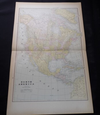
$4.13 Shipping Location: Bloomfield, United States This is an antique original colored lithographic map of North America from around 1890. The map is printed on a sheet and depicts the North American continent ... morein the late 19th century. The printing technique used is lithography, and the map is in its original state. The map is a county map and is likely to be of interest to collectors of antique maps and those interested in the history of North America.Measurements: 12” L x 10” HDetails of Map:Btich, Trutle u.Vulng vZA. Guadlers geogr Inst. Leipaig.The lithograph map overall is in Very God condition and shows sign of age.The lithograph map will be shipped using poly bags with background for protection.Free USPS Mail Shipping.
Buy It Now
$7.00 Shipping Location: North Wales, United States 1890 ANTIQUE CALDWELL ATLAS OF CAMBRIA COUNTY, PENNSYLVANIA-MAP OF CARROLL TP. ORIGINAL ANTIQUE ATLAS MAP PLEASE SEE PHOTOS AS PART OF THE DESCRIPTION ... moreCONDITION: MAP IS IN GOOD CONDITION. SIZE: APPROXIMATELY 10" X 13" SHIPPING: U.S. FIRST CLASS RATE - $7.00 - ANY ITEM WHICH SELLS FOR OVER $100 WILL REQUIRE INSURANCE WE COMBINE SHIPPING FOR MULTIPLE WINS. THANK YOU FOR YOUR INTEREST IN OUR AUCTIONS!.
Buy It Now
$7.95 Shipping Location: Dover, United States Issued 1890, NY by Scribner & Black. Scarce folio sheet late 19th century color lithographed map. Delaware - New Jersey.
Buy It Now
$8.30 Shipping Location: Celina, United States See pictures, maps are in good shape, atlas may be missing maps if it’s not pictures there is no guarantee it is in the book

Buy It Now
Free Shipping Location: Monroeville, United States 1890 ORIGINAL ANTIQUE CITY MAP OF NEW YORK/ MANHATTAN BROOKLYN This original antique map gives you an opportunity to examine in exquisite detail a piece ... moreof history. If you are interested in the past of this country and its people or have a desire to study where your family may have come from. Then this map gives you a rare look as the area was about 120 years ago. Once matted and framed, this map would make a perfect gift for a family member or friend they'll cherish forever. Origin of the map: The Home Knowledge Atlas" Published by Home Knowledge Association, Toronto, Canada. Date of issue: 1890 Size: The sheet measures 21 1/2" x 13 1/2" 54 x 34 cm) S/H: The map will be shipped by Air Mail. The shipping charge is: USA- 8.00 USD. World- 9.00 USD, Canada- 9.00 USD. The price includes the insurance and a strong, cardboard tube with plastic plugs. Attention! There is no additional shipping charge for multiple purchases! Pay me securely with any major credit card through PayPal! Payment methods: US/Canada Buyers: Paypal. International Buyers: Paypal. Click Here. Double your traffic. Get Vendio Gallery- Now FREE! USED USED. AN ORIGINAL ANTIQUE MAP. USED.
Buy It Now
$4.95 Shipping Location: Willow Grove, United States This is an ORIGINAL 1890 Nebraska map taken from a 1891 atlas. The 1890 date on this map is next to a population number near the map title. On the reverse ... moreside of this map page are images and text that do not relate to this map image.

Buy It Now
Free Shipping Location: Easton, United States GUARANTEED TO BE ORIGINAL AS STATED BELOW Authentic 1890 Color Map of Brazil Nothing Printed On The Back Page Measures Approximately 11 by 9 Inches(un-trimmed) ... moreEngraver: Rand McNally Co Chicago Publisher: Belford Clarke Co Chicago Publication: Americanized Encyclopedia Britannica This map may not have copyright date on it See pictures of title page and copyright below(not included in sale) Condition Very Good or Better: Fold In Center Shipped flat and secure Placed in acid free bag with backing board Sandwiched between 2 pieces of stiff cardboard Shipped via USPS 1st Class Parcel Mail with Delivery Confirmation/ Tracking SHIPPING MONDAY THRU FRIDAY ONLY We do not destroy good books. We save pages with historical information and images From books that are not usable in their current condition. Saving the past one page at a time! Be sure to checkout the other great items we are offering Just a quick note to thank you for checking out our item and to let you know alittle about us We are Karen and John. Wife and husband from the beautiful Lakes Region of New Hampshire We have been sellers since 1999 making some extra money and finding homes for interesting items We use different names to sort the items we offer that way we can be somewhat organized! Our names are IBEEBACK. IBEADULT, and SHOPNH4U And our items can be found by doing an advanced search by seller name You can also review our feedback files and ME page for more info how we treat all sales We hope we can do business. Inkfrog terapeak. InkFrog Analytics.
Buy It Now
Free Shipping Location: Dayton, United States This is a Color Map titled "Missouri River," 1890. Area In Blue Indicates Land Eroded Between 1879 and 1890! Map is in Very Good Condition! Any Browning ... moreIs Enhanced By My Phone!
Buy It Now
$10.20 Shipping Location: Tonawanda, United States Includes Counties, County Seats, Cities; many Small Towns and Villages; Ports, Military Airfields and Forts; Rivers, Streams, Lakes, Mountains, and other ... moretopographical features are located on this map.
Buy It Now
Free Shipping Location: Schertz, United States This Map was removed from an 1890 Mitchell's School Atlas and is in good acceptable condition. The map is not " new " or in " new " condition, it was ... moreprinted in 1890. The map is not dated. Study the photos carefully, this is the actual map you will receive.
Buy It Now
$4.95 Shipping Location: Willow Grove, United States This is an ORIGINAL 1890 map titled Virginia & W. Virginia which was taken from a 1891 atlas. The 1890 date on this map is next to a population number ... morenear the map title. On the reverse side of this map page are images and text that do not relate to this map image.
Buy It Now
$10.20 Shipping Location: Tonawanda, United States Includes Counties, County Seats, Cities; many Small Towns and Villages; Ports, Military Airfields and Forts; Rivers, Streams, Lakes, Mountains, and other ... moretopographical features are located on this map.

Buy It Now
Free Shipping Location: Monroeville, United States Ca. 1890's City of Baltimore + Maryland + Delaware + Washington DC- LARGE MAP On Obverse Side: Map of Baltimore with inset of City and Environs in ... moreupper right corner Copyright: 1891 Map Size: 26" X 19" Page Size: 29" X 22" Condition: Very Good- Crease at fold; overall age toning. Greater at the edge; 1" tear on right edge not affecting the map area. Comment: A very large and nicely detailed map. Including street names, parks, some buildings of significance, railways and light rail lines. On Reverse Side: Map of Maryland. Delaware and Washington D.C. with two Insets: 1) Baltimore and Environs; 2) Northwestern part of Maryland Copyright: 1893 Map Size: 19" X 12" Page Size: 22" X 14" Condition: Very Good with overall age toning. Darker toward the edge. Seldom available and relatively rare. I am pleased to offer these C. 1890's individual maps salvaged from a Rand McNally& Co.s Atlas(elephant folio) Each map is copyrighted with a year in the 1890's. All the maps are printed on heavy paper; they are aquatinted and display much more detail than smaller maps. Any relevant faults such as foxing, tears, holes or stains are disclosed if they affect the map area and are visually detracting. You will note that these maps are very larger and at least double the size of most other maps available. Rand McNally published a number of smaller-sized atlases, some with a similar name and same year, so in comparing, pay particular attention to the map size. The larger maps have more detail and additional description. These maps were tipped into the atlas and therefore contain no staple marks. Most of the maps are double-page and therefore have a crease down the center and the tipping strip on the reverse. The crease may be professionally pressed out. But the crease mark will never completely disappear. It should also be expected that the page edges will show some minor wear but the wear will not be noticeable after being matted and framed. The overall condition of these 100
Buy It Now
Free Shipping Location: Schertz, United States This piece was removed from an 1890 Atlas and is ingood acceptable condition. This original map is not "new" or in "new" condition, it was printed in ... more1890. Study the photos carefully, this is the actual map you will receive.
Buy It Now
$6.95 Shipping Location: Dover, United States Issued c. 1890 Philadelphia by Bradley, successor to S.A. Mitchell. This late Mitchell map was issued by Bradley for a short period before disappearing ... morefrom publication. Late 19th century lithographed map, with original hand color.
Buy It Now
Free Shipping Location: Florence, United States It's full of cool stuff! Thick paper.
Buy It Now
$4.95 Shipping Location: Willow Grove, United States This is an ORIGINAL 1890 map titled Map of Maryland and Delaware which was taken from a 1891 atlas. The 1890 date on this map is next to a population ... morenumber near the map title. On the reverse side of this map page are images and text that do not relate to this map image.
Buy It Now
Free Shipping Location: Carefree, United States MAP HAS SCALE BELOW TITLE AT BOTTOM LEFT. INSET MAP AT BOTTOM RIGHT OF NEWFOUNDLAND. DATE-1890, NOT ON MAP. GOOD CONDITION, MAP ON REVERSE, DISCOLORATION ... moreDUE TO AGE.
Buy It Now
$10.20 Shipping Location: Tonawanda, United States Includes Counties, County Seats, Cities; many Small Towns and Villages; Ports, Military Airfields and Forts; Rivers, Streams, Lakes, Mountains, and other ... moretopographical features are located on this map.
Buy It Now
Free Shipping Location: Sayville, United States Original 1891 Map of Colorado by Hunt& Eaton. Shows counties. Major cities, railroad lines, mountains and rivers throughout the state. Measures approximately ... more13.37" by 11" An attractive vintage lithograph that will look great matted and framed. See photo's. Free Shipping to anywhere in the US. Your order will always ship within ONE BUSINESS DAY. Well packaged in a sturdy waterproof mailer and sent with a delivery confirmatio n. I ship worldwide. Froo www.froo.com | Froo Cross Sell. Free Cross Sell, Cross promote, eBay Marketing, eBay listing Apps, eBay Apps, eBay Application.
Buy It Now
Free Shipping Location: Carefree, United States FAIR CONDITION-DIOSCOLORATION(MOSTLY AT LEFT AND RIGHT SIDES OF MAP, CREASES AS ISSUED, MAP LOOKS MUCH BETTER THAN MY PICS. ).
Buy It Now
$6.75 Shipping Location: Lilburn, United States

Buy It Now
Free Shipping Location: Monroeville, United States 1890 ANTIQUE MAP OF EASTERN UNITED STATES FLORIDA This original antique map gives you an opportunity to examine in exquisite detail a piece of history. ... moreIf you are interested in the past of this country and its people or have a desire to study where your family may have come from. Then this map gives you a rare look as the area was about 125 years ago. Once matted and framed, this map would make a perfect gift for a family member or friend they'll cherish forever. Origin of the map: Handy Reference Atlas" edited by John Bartholomew. Edinburgh, Scotland. Date of issue: 1890 Size: The sheet measures 8 1/2" x 7" 21.5 x 18 cm) S/H: The map will be shipped by Air Mail. The shipping charge is: USA- 2.00 USD/ Canada- 1.50 USD/ World- 4.00 USD. The price includes a strong. Secure envelope. Attention! There is no additional shipping charge for multiple purchases! Pay me securely with any major credit card through PayPal! Payment methods: US/Canada Buyers: Paypal. International Buyers: Paypal. Click Here. Double your traffic. Get Vendio Gallery- Now FREE!
Buy It Now
$4.00 Shipping Location: United States Superb, circa 1890, possibly earlier, antique large color lithographed map, titled Kentucky and Tennessee Western Half. Superb color lithography, printed ... moreon thick paper, with fine colors. Very detialed period map.
Buy It Now
Free Shipping Location: Marana, United States This Map was removed from a 1890 Atlas and is in good acceptable condition. ~ PEOPLES1890/013120. Including Hundreds of RareCivil War. 130+ years of aging. ... moreStudy the photos carefully, this is the actual map you.
Buy It Now
Free Shipping Location: Sayville, United States On the rear is an area and population table with data from the 1890 and 1900 census.
Buy It Now
$4.59 Shipping Location: Greenacres, United States
Buy It Now
$25.35 Shipping Location: Graettinger, United States Double Pages Map 1890 Rand McNally Atlas of the World

Buy It Now
$8.00 Shipping Location: Bulgaria c. 1890 FRANCE Alsace-Lorraine GERMANY Elsass Lothringen Antique Map IF THE SCANNER IS TOO SMALL TO SCAN THE WHOLE MAP. WE PRESENT TWO SCANS- OF THE UPPER ... morePART AND THE DOWN PART D E S C R I P T I O N Normal 0 21 false false false MicrosoftInternetExplorer4 THERE ARE NOT STAINS ON THE PRINT! IF YOU SEE SOME. THIS IS DUE TO THE SCANNER! S OME PART OF THE IMAGE MAY BE CUT DURING THE SCANNING! Normal 0 21 false false false MicrosoftInternetExplorer4 Normal 0 21 false false false MicrosoftInternetExplorer4 Due to the scanner the image is more yellow than in reality. There is a light stripe in the middle of the page. Caused by the scanner. In reality there is a fold in the center. This is an original old German map– a double page book plate. This original. Authentic antique map was a part of old German book. This is NOT a modern reproduction! VERY DECORATIVE. PERFECT FOR FRAMING! The map is printed in Leipzig. Germany, by the Bibliographishes Institut in 1899 SIZE– apr. 10’ 61/2’ inches or 25: 16 cm– perfect for framing. There is a fold in the center– the print was folded inside the book. The image presents the area of the print. Which will be visible when it is framed. ABOUT THE CONDITION– please check the scan carefully. SHIPPING We use SPECIAL PACK in order to protect the prints. We ship registered only. For USA and Canada– registered with priority. FEES- $ 7 for 1-4 prints. PAYMENTS Please pay by PAYPAL in a reasonable time after your purchase. We hate to open“non paid item” disputes or cases. But life is not only pleasure L. PLEASE NOTE! After reading this description. If there are any questions. Please ask us BEFORE bidding! If there is a problem with your item before or after it’s receiving. Please contact us ASAP. We’ll give our best to resolve the problem in a friendly manner.
Buy It Now
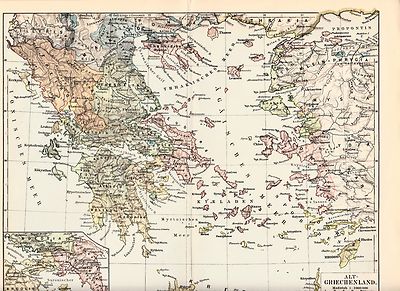
$8.00 Shipping Location: Bulgaria Ancient Greece Ancient History Antique Map Printed 1890. Original antique printed map issued in Leipzig(Germany) by the Bibliographisches Institut in ... more1890. It measures 9.4" x 11.8" 24 x 30 cm. This map is more than 100 year old and is good to very good condition(original fold line as issued) A nice map that would look great matted and framed. We do not sell modern reprints. All of our items are original antique pieces and it is important to keep in mind that many of them can have some imperfections. Discoloration and minimal spots, but this is due to age. Double page or centerfold means that it has a crease in the middle from where it originaly was folded and attached to a book. Please look at the pictures carefully, read the description of each item and examine the pictures with zoom. Payment We happily accept Paypal. Bank transfers are also accepted. Payment is appreciated within 7 days of invoicing. Shipping All of our prints and maps will be shipped from Bonn(Germany) We ensure that all items sold are packed securely and professionally. Once payment has been received we do our best to make sure all orders are shipped within two businnes days. Flat worldwide shipping rate of $8. We combine shipping costs. Multiple item buyers are welcome. No matter how many prints/ maps you buy you'll only pay $8 on shipping costs. We offer free shipping costs for orders over $100. Returns Returns are accepted within 14 days but we do request that you contact us before returning any item. inkfrog terapeak. I000000. InkFrog Analytics.
Buy It Now
$4.40 Shipping Location: Saco, United States This 2 Page Map was Harvested from an 1890 Rand McNally New Family Atlas as shown in last photo. Reverse side on one page will show Western Kansas and ... moreother Southern Georgia. 2 PagesShown as 21 3/4" x 14 1/8".

Buy It Now
Free Shipping Location: Monroeville, United States Fine Adornment of Virginia& West Virginia History. Impressive on Any Home or Office Wall. Imaginative Gift. 1890 Map of Virginia& West Virginia ... moreFine Hunt& Eaton Map. E.F. Fisk Engraved. Original 1890. 123-ys-old. Map is in Very Good/Excellent Condition: No writings. Marks, fraying, or foxing. Single fold as Issued. Not a Reproduction. Original Map Drawn& Engraved by E.F. Fisk for the 1890 Edition of Hunt& Eaton's People's Cyclopedia. Published by Hunt& Eaton, New York& San Francisco, and Jones Brothers& Company, Cincinnati& St. Louis; W.H. DePuy, Editor; E.F. Fisk, Engraver, 1890: a copy of the Title Page of which is Included. An Exceptional Map for the Collector or Makes Quite an Impressionable Gift for Someone Living in or From Virginia or West Virginia. I Sell Only Original Maps: No copies or reproductions. Press Here to View my Collection. Impressive on Any Home or Office Wall. Dimensions: 10.75" x 13.25" Fine Adornment of Virginia& West Virginia History Great for Family History/Genealogy as Map Shows Towns& Landmarks of 1890. Some of Which No Longer Exist Today. 1890 County Populations Listed on Reverse. Intricate Detail. Exceptional Color. Handsome Map. The Auction is for the Map Itself. A Frame is Not Included. The Framed Map Pictured is a Personal 1890 Map Featured to Show the Beauty of the Maps when Framed. Free Shipping Special. All Credit& Debit Cards and Electronic Checks accepted through Paypal. Maps are mailed within 1-3 days of payment& normally arrive within 3-7 days. Please email with any questions. Imaginative& Creative Gift for Someone Living in or From Virginia or West Virginia. Greetings from Historical Savannah. Georgia; founded 1733. Some. To beautify their halls, parlors, studies, libraries.loveth, getteth, and useth maps, charts, geographical globes. John Dee. Advisor to Elizabeth I. Press the Link Below to View My Collection. Powered by The free listing tool. List your items fast and easy and manage your active ite
Buy It Now
Free Shipping Location: Schertz, United States This Map was removed from an 1890 Mitchell's School Atlas and is in good acceptable condition. The map is not " new " or in " new " condition, it was ... moreprinted in 1890. The map is not dated. Study the photos carefully, this is the actual map you will receive.
Buy It Now
Free Shipping Location: Schertz, United States This Map was removed from an 1890 Rand Mc NALLY Atlas and is in good acceptable condition. The map is not " new " or in " new " condition, it was printed ... morein 1890. The map is not dated. Study the photos carefully, this is the actual map you will receive.

Buy It Now
Free Shipping Location: Syracuse, United States Authentic 1890 Color Map of Missouri Nothing Printed On The Back Page Measures Approximately 11 by 9 Inches Tall(un-trimmed) Engraver: Rand McNally& ... moreCo Chicago Publisher: Belford Clarke Co Chicago Publication: Americanized Encyclopedia Britannica This map may not have copyright date on it See pictures of title page and copyright below(not included in sale) Condition Very Good or Better: Fold In Center Shipped Flat and Secure In Acid Free Bag and Backing Board Shipping and handling charge = FREE Shipped via USPS Mail with Delivery Confirmation/Tracking SHIPPING MONDAY THRU FRIDAY ONLY Be sure to checkout the other great items we are offering Just a quick note to thank you for checking out our item and to let you know alittle about us We are Karen and John. Wife and husband from the beautiful Lakes Region of New Hampshire We have been sellers since 1999 making some extra money and finding homes for interesting items We use different names to sort the items we offer that way we can be somewhat organized! Our names are IBEEBACK. IBEADULT, and SHOPNH4U And our items can be found by doing an advanced search by seller name You can also review our feedback files and ME page for more info how we treat all sales We hope we can do business with you soon. Thank you. Karen and John inkfrog terapeak. Analyzing"Smart Counters" only at inkFrog inkFrog Analytics.
Buy It Now
Free Shipping Location: Schertz, United States This Map was removed from a 1890 McNally's Atlas and is in good acceptable condition. The map is not " new " or in " new " condition, it was printed in ... more1890. The map is not dated. Study the photos carefully, this is the actual map you will receive.
Buy It Now
$5.95 Shipping Condition: New Location: Las Vegas, United States Comanche, Apache, Cheyenne, Cherokee Indian districts are represented. Cities, Towns and Military forts are clearly labelled. Map of the Indian and Oklahoma ... moreTerritories. “Vibrant and bright! Pic does not do it justice.looks amazing!”.
Buy It Now
$4.95 Shipping Location: Willow Grove, United States There is a partial map image on the reverse side of this map page.
Buy It Now
Free Shipping Location: Kennebunkport, United States This Map was removed form an 1890 Atlas and is in good acceptable condition. Including Hundreds of RareCivil War. 120 years of aging. Study the photos ... morecarefully, this is the actual map you. will receive.
Buy It Now
$4.40 Shipping Location: Saco, United States Shown as21 3/4" x 14 1/8". Reverse side of one page will show Eastern Iowa and other shows Western Arkansas. Wonderful Gift for the person that has everything. ... moreNo Book Killer Here!

Buy It Now
Free Shipping Location: Monroeville, United States Fine Adornment of Iowa History. Impressive on Any Home or Office Wall. Imaginative Gift for Someone Living in or From Iowa. 1890 Map of Iowa Fine Hunt& ... moreEaton Map. E.F. Fisk Engraved. Original 1890. 122-ys-old. Map is in Good/Very Good Condition: No writings. Marks, fraying, or foxing. Single fold as Issued. Not a Reproduction. Original Map Drawn& Engraved by E.F. Fisk for the 1890 Edition of Hunt& Eaton's People's Cyclopedia. Published by Hunt& Eaton, New York& San Francisco, and Jones Brothers& Company, Cincinnati& St. Louis; W.H. DePuy, Editor; E.F. Fisk, Engraver, 1890: a copy of the Title Page of which is Included. An Exceptional Map for the Collector or Makes Quite an Impressionable Gift for Someone Living in or From Iowa. I Sell Only Original Maps: No copies or reproductions. Press Here to View my Collection. Impressive on Any Home or Office Wall. Dimensions: 10.75" x 13.25" 1890 County Populations on Reverse of Map Great for Family History as Map Shows Cities& Towns of 1890. Some of Which No Longer Exist Today. Imaginative& Creative Birthday. Christmas, Graduation, or Other Special Occasion Gift. The Auction is for the Map Itself. A Frame is Not Included. The Framed Map Pictured is a Personal 1890 Hunt Eaton Map Featured to Show the Beauty of the Maps when Framed. Free Shipping Special. All Credit& Debit Cards along with Electronic Checks accepted through Paypal. Please email with any questions. Fine Adornment of Iowa History. Greetings from Historical Savannah. Georgia; founded 1733. Some. To beautify their halls, parlors, studies, libraries.loveth, getteth, and useth maps, charts, geographical globes. John Dee. Advisor to Elizabeth I. Press the Link Below to View My Collection. Powered by The free listing tool. List your items fast and easy and manage your active items.
Buy It Now
Free Shipping Location: Monroeville, United States Home ~ Affiliations ~ Discounts ~ FAQs ~ Grading and Certification ~ Premium Shipping ~ About Us VINTAGE ART 1890 Print Map North America United States ... moreDominion Canada Mexico Alaska Jamaica Details Year: 1890 Type: Relief Line-block Map Grade: Very Fine ++ Authentication: Dual Certificates Image: Color Approximate Size(inches) 13.5 x 20.5 Approximate Size(cm) 34 x 52 Description and Condition This is an original 1890 color relief line-block map of North America. CONDITION This 121+ year old Item is rated Very Fine ++. Light wrinkling. Tightly cropped- left margin. No surface rub. Small tear. No water damage. Please note: There are five intersecting creases as a result of the original publication folding. To find other items from this specific collection in our eBay store. Please. Keywords specific to this image: Dominica. San Juan, Honduras, Nicaragua, Yucatan, Greenland, Labrador, Guatemala, Cuba, South America, Central America, Gulf of Mexico, Atlantic Ocean, Pacific Ocean, Baffin Island, Rupert's land, Nova Scotia, New York, Florida, California, Wisconsin, Ohio, Texas, Tennessee, Wyoming, Hudson Bay, Arctic Ocean. XGLC7C90 Product Pricing& What We Deliver At times we receive inquiries about our pricing. Especially for vintage advertising or historical halftone prints, and are asked why our prices are consistently higher than some other sellers of similar items. For the first five years of our business, we asked our primary consumer base what they wanted. Our primary consumers- historical societies, historians, archivists, curators, university professors, historical decorators, and collectors, etc. have diverse and specific needs and we've built our business to accommodate those needs, like no other seller worldwide. Below is what is unique about how and what we offer as the world's leader in print ephemera: Product Packaging. Every product is placed against custom black acid-free board with crystal-clear. Archival protective closures. We are the only sellers in the industry who provide display-
Buy It Now
Free Shipping Location: Dryden, United States As shown. (paper box)
Buy It Now
Free Shipping Location: Schertz, United States This Map was removed from an 1890 Rand Mc NALLY Atlas and is in good acceptable condition. The map is not " new " or in " new " condition, it was printed ... morein 1890. The map is not dated. Study the photos carefully, this is the actual map you will receive.
Buy It Now
Free Shipping Location: Kennebunkport, United States This Map was removed form an 1890 Atlas and is in good acceptable condition. Including Hundreds of RareCivil War. 120 years of aging. Study the photos ... morecarefully, this is the actual map you. will receive.
Buy It Now
Free Shipping Location: Graettinger, United States Rand McNally Standard World Atlas Map. Has map of Urban Population on back.
Buy It Now
$14.00 Shipping Location: North Hampton, United States Original USGS 1890 Geololgical Series topographical survey map for Brimfield, Sturbridge, Southbridge, Warren, Brookfield, Charlton & Holland, MA. This ... moreis the very first USGS map series of these towns, titled "Brookfield Sheet" at the top and was produced from surveys taken between 1885-1887 and printed by Forbes Litho, Boston, MA.
Buy It Now
$5.79 Shipping Location: Fairport, United States An extracted foldout book plate. A nice find.
Buy It Now
$9.99 Shipping Location: Ivanhoe, Australia He was commissioned to engrave the map of Treasure Island for Robert Louis Stevenson. Date: - 1890. Turkey in Asia, Persia, Arabia &c. Age of map color: ... more- Original. A man of high standards, as were his successors; he was a superb engraver, engraving becoming the foundation of the firm; lithography would follow later.

Buy It Now
$8.00 Shipping Location: Bulgaria 1890 CZECH REP. PRAG PRAHA City Plan Antique Map D E S C R I P T I O N Normal 0 21 false false false MicrosoftInternetExplorer4 THERE ARE NOT ANY SPOTS ... moreOR STAINS ON THE PRINT! THIS APPEARS DUE TO THE SCANNER. S OME PART OF THE IMAGE MAY BE CUT DURING THE SCANNING! Normal 0 21 false false false MicrosoftInternetExplorer4 Normal 0 21 false false false MicrosoftInternetExplorer4 Due to the scanner the image is more yellow than in reality. There is a light stripe in the middle of the page. Caused by the scanner. In reality there is a fold in the center. This is an original old German map– a double page book plate. This original. Authentic antique map was a part of old German book. This is NOT a modern reproduction! VERY DECORATIVE. PERFECT FOR FRAMING! The map is printed in Leipzig. Germany, by the Bibliographishes Institut in 1890 SIZE– apr. 12’ 10’ inches– perfect for framing. There is a fold in the center– the print was folded inside the book. The image presents the area of the print. Which will be visible when it is framed. ABOUT THE CONDITION– please check the scan arefully. SHIPPING We use a tube in order to protect the prints. We ship registered only. For USA and Canada– registered with priority. FEES- $ 8 for 1-3 prints in a tube. $ 19 for up to 20 prints. PAYMENTS Please pay by PAYPAL in a reasonable time after your purchase. We hate to open“non paid item” disputes or cases. But life is not only pleasure L. PLEASE NOTE! After reading this description. If there are any questions. Please ask us BEFORE bidding! If there is a problem with your item before or after it’s receiving. Please contact us ASAP. We’ll give our best to resolve the problem in a friendly manner.
|
|
|
In
|
1890 Original Antique Map of NEVADA Detailed Color Cities Towns Railroads
Here is an authentic antique map that was published in the early 1890s. It would be easy to frame for a handsome presentation for your home or office. Title: Nevada Date: 1890s Source: Not known Size: 12.5 x 10 inches Description: Excellent original engraving of the state of Nevada showing great detail. Including cities, towns, villages, railroads. A well designed map. Interesting regions are marked, such as Black Rock Desert or Valley of the Mud Lakes, Gold Mtn. Peak, Vegas Wash, Disaster Peak and much more. Condition: Very Good. The paper is supple. Clean, and unmarked, with a fold down the center as issued. Shipping: The map will be packaged with care and securely mailed within 24 hours of payment. Thanks for looking! Please feel free to email me at any time with your thoughts or questions- I am always happy to respond! Powered by The ... morefree listing tool. List your items fast and easy and manage your active items.
|
|
|
1890 ANTIQUE MAP WESTERN USA CALIFORNIA ARIZONA TEXAS
1890 ANTIQUE MAP WESTERN USA CALIFORNIA ARIZONA TEXAS This original antique map gives you an opportunity to examine in exquisite detail a piece of history. If you are interested in the past of this country and its people or have a desire to study where your family may have come from. Then this map gives you a rare look as the area was about 125 years ago. Once matted and framed, this map would make a perfect gift for a family member or friend they'll cherish forever. Origin of the map: Handy Reference Atlas" edited by John Bartholomew. Edinburgh, Scotland. Date of issue: 1890 Size: The sheet measures 8 1/2" x 7" 21.5 x 18 cm) MINOR REPAIRS ON THE MARGIN. S/H: The map will be shipped by Air Mail. The shipping charge is: USA- 2.00 USD/ Canada- 1.50 USD/ World- 4.00 USD. The price includes a strong. Secure envelope. Attention! ... moreThere is no additional shipping charge for multiple purchases! Pay me securely with any major credit card through PayPal! Payment methods: US/Canada Buyers: Paypal. International Buyers: Paypal. Click Here. Double your traffic. Get Vendio Gallery- Now FREE!
|
|
|
1890 ANTIQUE MAP OF NEW MEXICO / VERSO MAP OF COLORADO
1890 ANTIQUE MAP OF NEW MEXICO/ VERSO MAP OF COLORADO This original antique map gives you an opportunity to examine in exquisite detail a piece of history. If you are interested in the past of this country and its people or have a desire to study where your family may have come from. Then this map gives you a rare look as the area was about 125 years ago. Once matted and framed, this map would make a perfect gift for a family member or friend they'll cherish forever. Origin of the map: The Home Knowledge Atlas" Published by Home Knowledge Association, Toronto, Canada. Date of issue: 1890 Size: The sheet measures 13 1/2" x 11 1/4" 34 x 28 cm) S/H: The map will be shipped by Air Mail. The shipping charge is: USA- 7.50 USD. World- 8.50 USD, Canada- 8.50 USD. The price includes the insurance and a strong, cardboard tube with ... moreplastic plugs. Attention! There is no additional shipping charge for multiple purchases! Pay me securely with any major credit card through PayPal! Payment methods: US/Canada Buyers: Paypal. International Buyers: Paypal. Click Here. Double your traffic. Get Vendio Gallery- Now FREE!
|
|
|
1890 ANTIQUE MAP OF ARIZONA / VERSO MAP OF UTAH
1890 ANTIQUE MAP OF ARIZONA/ VERSO MAP OF UTAH This original antique map gives you an opportunity to examine in exquisite detail a piece of history. If you are interested in the past of this country and its people or have a desire to study where your family may have come from. Then this map gives you a rare look as the area was about 125 years ago. Once matted and framed, this map would make a perfect gift for a family member or friend they'll cherish forever. Origin of the map: The Home Knowledge Atlas" Published by Home Knowledge Association, Toronto, Canada. Date of issue: 1890 Size: The sheet measures 13 1/2" x 11 1/4" 34 x 28 cm) S/H: The map will be shipped by Air Mail. The shipping charge is: USA- 7.50 USD. World- 8.50 USD, Canada- 8.50 USD. The price includes the insurance and a strong, cardboard tube with plastic ... moreplugs. Attention! There is no additional shipping charge for multiple purchases! Pay me securely with any major credit card through PayPal! Payment methods: US/Canada Buyers: Paypal. International Buyers: Paypal. Click Here. Double your traffic. Get Vendio Gallery- Now FREE!
|
|
|
RARE ANTIQUE MAP OF ARIZONA AND NEW MEXICO PUBLISHED BY MITCHELL IN IN C. 1890
Rare. Antique double-page map of Arizona and New Mexico published by Mitchell in c.1890. Excellent impression with beautiful geographic details. Original full color: red, green, yellow, and blue. Moderate foxing. The edges of the map are in good condition, with only a few slight tears in the outside margins of the map. These have been repaired using archival quality tape on the back. This is an excellent find for collectors of antique maps! Title: County and Township Map of Arizona and New Mexico. Dimensions: approx. 15½ x 23” ILC: US_SE05_LP We guarantee that this is a real. Genuine, high quality antique map, not a facsimile, reproduction, or copy. Genuine antique maps are an excellent investment and have consistently increased in value over the years. Their unique combination of history and visual beauty and interest makes antique ... moremaps a pleasure to own or give to friends. Please view our selection of other genuine. Affordable antique maps in our Ebay Store. Also take time to view feedback from the many satisfied map collectors who have purchased from our gallery. We guarantee that this map is of superior investment quality and will continue to appreciate in value. Normal 0 false false false EN-US X-NONE X-NONE Welcome to Le Chateau Art Gallery! We are a specialty gallery dealing with a wide variety of antique and vintage books. Artworks, coins, and collectibles. Our office is open Monday through Friday from 9AM until 6PM Eastern Time. Please read our descriptions thoroughly and ask questions before making your purchase. SHIPPING& HANDLING Shipping fees: We are proud to offer low-cost shipping within the United States! Processing time: All items are handled for shipping within one day of receiving payment. Shipping method: Items are shipped via United States Postal Service and FedEx. Estimated arrival time: 7-10 business days. Delivery Confirmation and tracking provided for all items. International orders: Calculated via location. We will do our best to provide the lowest costs. First Class Mail Intern
|
|
|
1890 Antique Bradley Atlas Map Arizona New Mexico Rare
Map Maker: Bradley Size: 16" x 26" Region: United States: Arizona and New Mexico Bid now on these rare. Valuable, authentic, antique map of Arizona and New Mexico from an 1890 Bradley's Atlas of the World. This impressive map is in Very Good collectible condition with minor wear. Bradley was one of the most skilled and renowned mapmakers of the 19 th century. Bradley's maps are extremely collectible and sought after by discriminating map collectors because of their historical prestige. Superior engraving, and exquisite coloring. We guarantee that this is a real. Genuine, high quality antique map, not a facsimile, reproduction, or copy. Genuine antique maps are an excellent investment and have consistently increased in value over the years. Their unique combination of history and visual beauty and interest makes antique maps ... morea pleasure to own or give to friends. Please view our selection of other genuine. Affordable antique maps in our Ebay Store. Also take time to view feedback from the many satisfied map collectors who have purchased from our gallery. We guarantee that this map is of superior investment quality and will continue to appreciate in value. On Aug-18-10 at 12:40:57 PDT. Seller added the following information: Check out Our Website for better deals on this item and others in our store at: www.lechateaugallery.com Books. Paintings, Prints, Posters, Coins, And More! Normal 0 false false false EN-US X-NONE X-NONE Welcome to Le Chateau Art Gallery! We are a specialty gallery dealing with a wide variety of antique and vintage books. Artworks, coins, and collectibles. Our office is open Monday through Friday from 9AM until 6PM Eastern Time. Please read our descriptions thoroughly and ask questions before making your purchase. SHIPPING& HANDLING Shipping fees: We are proud to offer low-cost shipping within the United States! Processing time: All items are handled for shipping within one day of receiving payment. Shipping method: Items are shipped via United States Postal Service and Fed
|
|
|
Field of Shiloh Fort Craig New Mexico c.1890 huge detailed antique Civil War map
Operations near Fort Craig. N. Mex. Sketch of the Battle-Field of Roanoke Island Map of the Field of Shilog near Pittsburg Landing. Tenn. Showing the Positions of the U.S. Forces under the Command of Maj. Gen. U.S. Grant and Maj. Gen D.C. Buell Issued c.1891-95. Washington, D.C. by the US Government Printing Office. Printed by Julius Bien& Co. Lithographers, N.Y. Published under the direction of Daniel S. Lamont. Secretary of War. Originally issued in the"Atlas to Accompany the Official Records of the Union and Confederate Armies" Which was issued in parts to subscribers over a period of years, but is sometimes found bound up later into atlas volumes. This oversize and attractive lithographed 19th century sheet depicts in great detail the specific events and locations of the Civil War battles or regions depicted. Astoundingly ... moredetailed. With an emphasis upon precision and accuracy, attempting to capture visually and cartographically the regions and battles depicted. Unlike topographical maps or state maps of the era issued by most cartographers. The underlying premise of these Civil War maps was to depict the cartography as it specifically related to events of the Civil War. Thus, individual battles, small forts, troop movements, local rail lines, panoramic views, etc. are often rendered and explained with precision in a manner quite unique. Also, the very large format of the sheet allows for a level of detail which makes the map perfect for display or study by a Civil War buff, since the detail it contains is to be found almost no where else on this scale. In Good+ to VG. Mostly clean condition. some light damp staining across the blank margin which will disappear once matted and s ome light minor age-wear- typical for maps of this era. And in no way offensive or severe. Overall a pleasing example of this interesting map. Which is well worthy of display. Elephant folio sheet measures c. 29 1/4" W x 18 1/8" H. Printed area measures c. 27" W x 13 3/8" H. Original center-fold line a
|
|
|
1890 ANTIQUE MAP: UTAH LAKE, RESERVOIR SITE. NEAR PROVO UT
1890 ANTIQUE MAP: UTAH LAKE. RESERVOIR SITE SEGREGATED" BY F.H. NEWELL. NEAR PROVO. PUBLISHED BY THE GOVERNMENT PRINTING OFFICE. WASHINGTON, DC. 1890 FOR THE 11th ANNUAL REPORT OF THE UNITED STATES GEOLOGICAL SURVEY. Size: Approx 11.25 X 16.5 INCHES(ENTIRE SHEET) IMAGE AREA A LITTLE SMALLER. Condition: VERY GOOD. A FEW FLAWS. SEE PHOTO. Due to age. Small imperfections are to be expected. Please view the photos to make your own assessment. THREE FOLDS, AS PUBLISHED& BOUND INTO BOOK. Returns: Any item may be returned for a refund. Please contact us within 7 days of receipt of your item if you feel an error has been made. We do not deal in modern reproductions. All of our prints& maps are original and authentic. Please browse other prints& maps at our store. Inv# M1890-11 inkfrog terapeak. I000000.
|
|
|
Old Antique 1890 Map California RR Railroad Authentic Vintage City Town Township
Authentic 1890 Color Map of California Nothing Printed On The Back Page Measures Approximately 11 by 9 Inches Tall(un-trimmed) Engraver: Rand McNally& Co Chicago Publisher: Belford Clarke Co Chicago Publication: Americanized Encyclopedia Britannica This map may not have copyright date on it See pictures of title page and copyright below(not included in sale) Condition Very Good or Better: Fold In Center Shipped Flat and Secure In Acid Free Bag and Backing Board Shipping and handling charge = FREE Shipped via USPS Mail with Delivery Confirmation/Tracking SHIPPING MONDAY THRU FRIDAY ONLY Be sure to checkout the other great items we are offering Just a quick note to thank you for checking out our item and to let you know alittle about us We are Karen and John. Wife and husband from the beautiful Lakes Region of New Hampshire We have been ... moresellers since 1999 making some extra money and finding homes for interesting items We use different names to sort the items we offer that way we can be somewhat organized! Our names are IBEEBACK. IBEADULT, and SHOPNH4U And our items can be found by doing an advanced search by seller name You can also review our feedback files and ME page for more info how we treat all sales We hope we can do business with you soon. Thank you. Karen and John inkfrog terapeak. Analyzing"Smart Counters" only at inkFrog inkFrog Analytics.
|
|
|
1890 Old Vintage Map Colorado Railroad RR County City Town Authentic Antique
Authentic 1890 Color Map of Colorado Nothing Printed On The Back Page Measures Approximately 11 by 9 Inches Tall(un-trimmed) Engraver: Rand McNally& Co Chicago Publisher: Belford Clarke Co Chicago Publication: Americanized Encyclopedia Britannica This map may not have copyright date on it See pictures of title page and copyright below(not included in sale) Condition Very Good or Better: Fold In Center NOTE: the entire map did not fit on our scanner Shipped Flat and Secure In Acid Free Bag and Backing Board Shipping and handling charge = FREE Shipped via USPS Mail with Delivery Confirmation/Tracking SHIPPING MONDAY THRU FRIDAY ONLY Be sure to checkout the other great items we are offering Just a quick note to thank you for checking out our item and to let you know alittle about us We are Karen and John. Wife and husband from the beautiful ... moreLakes Region of New Hampshire We have been sellers since 1999 making some extra money and finding homes for interesting items We use different names to sort the items we offer that way we can be somewhat organized! Our names are IBEEBACK. IBEADULT, and SHOPNH4U And our items can be found by doing an advanced search by seller name You can also review our feedback files and ME page for more info how we treat all sales We hope we can do business with you soon. Thank you. Karen and John inkfrog terapeak. Analyzing"Smart Counters" only at inkFrog inkFrog Analytics.
|
|
|
Old 1890 Map Utah Authentic Indian Reservation RR Railroad Antique Vintage Color
Authentic 1890 Color Map of Utah Nothing Printed On The Back Page Measures Approximately 11 by 9 Inches Tall(un-trimmed) Engraver: Rand McNally& Co Chicago Publisher: Belford Clarke Co Chicago Publication: Americanized Encyclopedia Britannica This map may not have copyright date on it See pictures of title page and copyright below(not included in sale) Condition Very Good or Better: Fold In Center Shipped Flat and Secure In Acid Free Bag and Backing Board Shipping and handling charge = FREE Shipped via USPS Mail with Delivery Confirmation/Tracking SHIPPING MONDAY THRU FRIDAY ONLY Be sure to checkout the other great items we are offering Just a quick note to thank you for checking out our item and to let you know alittle about us We are Karen and John. Wife and husband from the beautiful Lakes Region of New Hampshire We have been sellers ... moresince 1999 making some extra money and finding homes for interesting items We use different names to sort the items we offer that way we can be somewhat organized! Our names are IBEEBACK. IBEADULT, and SHOPNH4U And our items can be found by doing an advanced search by seller name You can also review our feedback files and ME page for more info how we treat all sales We hope we can do business with you soon. Thank you. Karen and John inkfrog terapeak. Analyzing"Smart Counters" only at inkFrog inkFrog Analytics.
|
|
|
Old Authentic 1890 Map Nevada RR Railroad Indian Reservation Antique Vintage
Authentic 1890 Color Map of Nevada Nothing Printed On The Back Page Measures Approximately 11 by 9 Inches Tall(un-trimmed) Engraver: Rand McNally& Co Chicago Publisher: Belford Clarke Co Chicago Publication: Americanized Encyclopedia Britannica This map may not have copyright date on it See pictures of title page and copyright below(not included in sale) Condition Very Good or Better: Fold In Center Shipped Flat and Secure In Acid Free Bag and Backing Board Shipping and handling charge = FREE Shipped via USPS Mail with Delivery Confirmation/Tracking SHIPPING MONDAY THRU FRIDAY ONLY Be sure to checkout the other great items we are offering Just a quick note to thank you for checking out our item and to let you know alittle about us We are Karen and John. Wife and husband from the beautiful Lakes Region of New Hampshire We have been sellers ... moresince 1999 making some extra money and finding homes for interesting items We use different names to sort the items we offer that way we can be somewhat organized! Our names are IBEEBACK. IBEADULT, and SHOPNH4U And our items can be found by doing an advanced search by seller name You can also review our feedback files and ME page for more info how we treat all sales We hope we can do business with you soon. Thank you. Karen and John inkfrog terapeak. Analyzing"Smart Counters" only at inkFrog inkFrog Analytics. Dhep.RcmdId ViewItemDescV4,RlogId p4%60bo7%60jtb9%3Fuk%601d72f%2Bishm%3Ed%7Fhep-143675fad31-0xd3-
|
|
|
ca 1890 SAN FRANCISCO CALIFORNIA USA AMERICA Antique Map
Photo gallery Year ca 1890 From Brockhaus konversations lexikon Type Antique map Condition Good(as seen on the scan) Reverse Side: blank Paper thinckness normal Size with margins(inches) approximately: 6.1 x 9,6 inches Size with margins(cm) approximately: 15.5 x 24,5 cm- If You are interested In more than one item. Don’t worry we will combine shipping costs for You. Once You have finished shopping please let us know. And we will sent an invoice with a combined shipping cost. We are always trying to ship ASAP(within 1-2 business days) All of our orders will be shipped well protected(flat cardboard envelopes or tubes) We are always shipping via registered mail and we will provide You with a tracking number. unfortunately not all countries track packages) To the US we are shipping via USPS. We are shipping to the address from the PayPal payment- ... moreRemember that all the items are shipped from Europe(Poland) On average it takes between 7 to 14 business days for the package to reach You(but once the item is sent we do not have any control over possible delays) Shipping rates for combined shipping: 1-3 prints: 10 $ 4-6 prints: 11 $ 7-9 prints: 12 $ and so forth. We accept PayPal payments- The payment is appreciated within 5 business days If You are interested in buying more prints. Please don’t hesitate to write. We are open to offers and willing to haggle over prices: We are a small family business located in a Polish capital. Selling and buying antiques has been our profession for over 20 years. We love what we do. And are always trying to provide the best service possible. We offer a huge variety of old prints. If there’s something we don’t have, just ask we might be able to find it for You. Somos una pequena empresa localizada en capital de Varsovia. La compra- venta de antiquedades ha sido nuestro trabajo por mas de 20 anos. Estamos totalmente dedicados a lo que hacemos. Tenemos muchisimas graficas en nuestra oferta. Si hay alguna grafica que de momento no tenemos. Preguntanos q
|
|
|
1890 ARIZONA NEW MEXICO antique COLOR map INDIAN RES.
A framed antique map makes a great gift for any occasion! A beautiful antique railroad map of ARIZONA AND NEW MEXICO INDIAN RESERVATIONS AND FORTS Original antique map printed in 1890 The date is on the map. The map is about 10.5 x 13. This map is in excellent condition. There are no holes. Smudges, etc. Great condition for over 120 years old. The most interesting part of this map is that all the railroads are on it. And each stop is marked and the town listed! This map predates roads. Printed just 35 years after the end of the Civil War. This is not a copy. It's an authentic original antique map from an old atlas. Email me at if you have any questions. Or want to know if your town is on the map. This map is about 10.5 x 13 and enough to frame with a border. Statistics such as Population. Area, Land Surface, State Capital, County Seat ... moreare listed. I will ship the map flat and protected USPS first class mail. I self-insure. So any damage and I will refund all your money including postage both ways. If you aren't happy with anything about the map, I will refund your money plus shipping one way. I am a picture framer and antique map collector! I guarantee you will love this map or you can return it for a full refund including postage! You can't lose. Powered by On Aug-01-07 at 18:13:39 PDT. Seller added the following information: On May-27-12 at 05:30:36 PDT. Seller added the following information:
|
|
|
Old Vintage Map Nevada NV RR Railroad Shoshone Indian Reservation Antique 1890
GUARANTEED TO BE ORIGINAL AS STATED BELOW Authentic 1890 Color Map of Nevada Nothing Printed On The Back Page Measures Approximately 11 by 9 Inches Tall(un-trimmed) Engraver: Rand McNally& Co Chicago Publisher: Belford Clarke Co Chicago Publication: Americanized Encyclopedia Britannica This map may not have copyright date on it See pictures of title page and copyright below(not included in sale) Condition Very Good or Better: Fold In Center Shipped Flat and Secure In Acid Free Bag and Backing Board Shipping and handling charge = FREE Shipped via USPS Mail with Delivery Confirmation/Tracking SHIPPING MONDAY THRU FRIDAY ONLY Be sure to checkout the other great items we are offering Just a quick note to thank you for checking out our item and to let you know alittle about us We are Karen and John. Wife and husband from the beautiful Lakes ... moreRegion of New Hampshire We have been sellers since 1999 making some extra money and finding homes for interesting items We use different names to sort the items we offer that way we can be somewhat organized! Our names are IBEEBACK. IBEADULT, and SHOPNH4U And our items can be found by doing an advanced search by seller name You can also review our feedback files and ME page for more info how we treat all sales We hope we can do business with you soon. Thank you. Karen and John inkfrog terapeak. Analyzing"Smart Counters" only at inkFrog inkFrog Analytics.
|
|
|
1890 Antique Map: Profile of Fresno County, California, CA By Goldstone.
1890 Antique Map: Profile of Fresno County. California, CA By L.P. Goldstone. Scarce Map. FROM: Tenth Annual Report of the State Mineralogist. For the Year Ending December 1, 1890. Sacramento: State Office, J.D. Young, Supt. of State printing, 1890. Size: Approx 22.5 inches x 9 inches(ENTIRE PAGE) Condition: VERY GOOD. See Photo) Several folds. As published& bound into book. Returns: Any item may be returned for a refund. Please contact us within 14 days of receipt of your item if you feel an error has been made. We do not deal in modern reproductions. All of our maps are original and authentic. Affordable Auction Management and Image Hosting Solutions@ inkFrog i000000.
|
|
|
Original 1890 Antique Map CALIFORNIA NEVADA San Mateo Redwood Ripon CA Reno NV
Fine Adornment of California& Nevada History. Impressive on Any Home or Office Wall. Imaginative& Creative Gift. 1890 Map of California& Nevada Fine Hunt& Eaton Map. Engraved by L.B. Folger. Original 1890. 124-yrs-old. Map is in Good/Very Good condition: No marks or writings. Mild foxing. Nominal fraying. Single fold as Issued. Not a Reproduction. Original Map Drawn& Engraved by E.F. Fisk for Hunt& Eaton's 1890 Edition of The People's Cyclopaedia of Universal Knowledge. Published by Phillips& Hunt, New York& San Francisco, 1890; Edited by William H. Dupuy. E.F. Fisk, Engraver; a Copy of the Title Page of which is Included. An Exceptional Map for the Collector or Makes Quite An Impressionable Gift for Someone living in or from California or Nevada. I Sell Only Original Antique Maps: No copies or reproductions. ... morePress Here to View My Collection. Impressive On Any Home or Office Wall Dimensions: 10.75" x 13" L.B. Folger Engraved. Intricate Detail. Handsome Map 1890 County Population Listed on Reverse. Great for Family History as Map Shows Towns& Landmarks of 1890. Some of which No Longer Exist Today. Imaginative& Creative Birthday. Christmas, Graduation, or Other Special Occasion Gift. The Auction is for the Map Itself. A Frame is Not Included. The Framed Map Pictured is a Personal 1890 Hunt& Eaton Map Featured to Show the Beauty of the Maps when Framed. Free Shipping Special. All Credit Cards. Debit Cards, Electronic Checks Accepted Through Paypal. Maps are mailed within 1-3 days of payment and normally arrive within 3-5 days. Please email with any questions. Fine Adornment of California& Nevada History. Greetings from Historical Savannah. Georgia; founded 1733. Some. To beautify their halls, parlors, chambers, or libraries.loveth, getteth, and useth maps, charts, geographical globes. John Dee. Advisor to Elizabeth I. Press The Store Link Below To View My Collection. Powered by The free listing tool. List your items fast and easy and manage your activ
|
|
|
Antique Original 1890 Map UTAH Salt Lake City Provo Morgan Ogden Logan Heber UT
Fine Adornment of Utah History. Impressive on Any Home or Office Wall. Imaginative& Creative Gift. 1890 Map of Utah Fine Hunt& Eaton Map. Engraved by L.B. Folger. Original 1890. 124-yrs-old. Map is in Good/Very Good condition: No marks. Writings, rips, tears, or foxing. Nominal fraying. Single fold as Issued. Not a Reproduction. Original Map Drawn& Engraved by L.B. Folger for Hunt& Eaton's 1890 Edition of The People's Cyclopaedia of Universal Knowledge. Published by Phillips& Hunt, New York& San Francisco, 1890; Edited by William H. Dupuy. L.B. Folger, Engraver; a Copy of the Title Page of which is Included. An Exceptional Map for the Collector or Makes Quite An Impressionable Gift for Someone living in or from Utah. I Sell Only Original Antique Maps: No copies or reproductions. Press Here to View My Collection. ... moreImpressive On Any Home or Office Wall Dimensions: 10.75" x 13" L.B. Fogler Engraved Map. Intricate Detail. Beautiful Color. Great for Family History as Map Shows Towns& Landmarks of 1890. Some of which No Longer Exist Today. 1890 Population of Counties on Reverse. Imaginative& Creative Birthday. Christmas, Graduation, or Other Special Occasion Gift. The Auction is for the Map Itself. A Frame is Not Included. The Framed Map Pictured is a Personal 1890 Hunt& Eaton Map Featured to Show the Beauty of the Maps when Framed. Free Shipping Special. All Credit Cards. Debit Cards, Electronic Checks Accepted Through Paypal. Maps are mailed within 1-3 days of payment and normally arrive within 3-5 days. Please email with any questions. Fine Adornment of Utah History. Greetings from Historical Savannah. Georgia; founded 1733. Some. To beautify their halls, parlors, chambers, or libraries.loveth, getteth, and useth maps, charts, geographical globes. John Dee. Advisor to Elizabeth I. Press The Store Link Below To View My Collection. Powered by The free listing tool. List your items fast and easy and manage your active items.
|
|
|
Genuine Original 1890 Antique Map of UTAH UT AND ARIZONA AZ
Authentic 1890 ANTIQUE COLOR MAP of UTAH& ARIZONA- 12 4 Years Old! This is a genuine 1890 map-NOT a reproduction. Measures 9 3/4" by 13" Excellent condition. see photos. Would make a perfect gift or addition to your collection! It will be very carefully packaged to ensure safe arrival.
|
|
|
1890 ORIGINAL ANTIQUE MAP OF CALIFORNIA LOS ANGELES SAN FRANCISCO NEVADA OREGON
1890 ORIGINAL ANTIQUE MAP OF CALIFORNIA LOS ANGELES SAN FRANCISCO NEVADA OREGON This original antique map gives you an opportunity to examine in exquisite detail a piece of history. If you are interested in the past of this country and its people or have a desire to study where your family may have come from. Then this map gives you a rare look as the area was about 120 years ago. Once matted and framed, this map would make a perfect gift for a family member or friend they'll cherish forever. Origin of the map: The Home Knowledge Atlas" Published by Home Knowledge Association, Toronto, Canada. Date of issue: 1890 Size: The sheet measures 21 1/2" x 13 1/2" 54 x 34 cm) S/H: The map will be shipped by Air Mail. The shipping charge is: USA- 8.00 USD. World- 9.00 USD, Canada- 9.00 USD. The price includes the insurance and a ... morestrong, cardboard tube with plastic plugs. Attention! There is no additional shipping charge for multiple purchases! Pay me securely with any major credit card through PayPal! Payment methods: US/Canada Buyers: Paypal. International Buyers: Paypal. Click Here. Double your traffic. Get Vendio Gallery- Now FREE! USED USED. AN ORIGINAL ANTIQUE MAP. USED.
|
|
|
1890 Antique Map: Ophir & Duncan Hills Gold Mining District, Placer County CA
1890 Antique Map: Ophir& Duncan Hills Gold Mining District. Placer County CA. Single-page Index to map included. By J.B. Hobson. Rare Map. FROM: Tenth Annual Report of the State Mineralogist. For the Year Ending December 1, 1890. Sacramento: State Office, J.D. Young, Supt. of State printing, 1890. Size: Approx 9 inches x 6 inches(ENTIRE PAGE) Condition: VERY GOOD. Returns: Any item may be returned for a refund. Please contact us within 14 days of receipt of your item if you feel an error has been made. We do not deal in modern reproductions. All of our prints are original and authentic. Please browse other prints at our store. Affordable Auction Management and Image Hosting Solutions@ inkFrog i000000.
|
|
|
1890 NORTH AMERICA CANADA USA WEST COAST Antique Map
1890 NORTH AMERICA CANADA USA WEST COAST Antique Map D E S C R I P T I O N Normal 0 21 false false false MicrosoftInternetExplorer4 THERE ARE NOT ANY SPOTS OR STAINS ON THE PRINT! THIS APPEARS DUE TO THE SCANNER. S OME PART OF THE IMAGE MAY BE CUT DURING THE SCANNING! Normal 0 21 false false false MicrosoftInternetExplorer4 Normal 0 21 false false false MicrosoftInternetExplorer4 Due to the scanner the image is more yellow than in reality. There is a light stripe in the middle of the page. Caused by the scanner. In reality there is a fold in the center. This is an original old German map– a double page book plate. This original. Authentic antique map was a part of old German book. This is NOT a modern reproduction! VERY DECORATIVE. PERFECT FOR FRAMING! The map is printed in Leipzig. Germany, by the Bibliographishes Institut in 1890 SIZE– ... moreapr. 12’ 10’ inches– perfect for framing. There is a fold in the center– the print was folded inside the book. The image presents the area of the print. Which will be visible when it is framed. ABOUT THE CONDITION– please check the scan arefully. SHIPPING We use a tube in order to protect the prints. We ship registered only. For USA and Canada– registered with priority. FEES- $ 8 for 1-3 prints in a tube. $ 19 for up to 20 prints. PAYMENTS Please pay by PAYPAL in a reasonable time after your purchase. We hate to open“non paid item” disputes or cases. But life is not only pleasure L. PLEASE NOTE! After reading this description. If there are any questions. Please ask us BEFORE bidding! If there is a problem with your item before or after it’s receiving. Please contact us ASAP. We’ll give our best to resolve the problem in a friendly manner.
|
|
|
Antique 1890s Map Two Page Color Fold Out California 1890
This is an Original 1890s Antique Map. The page measures 9 inches by 10 1/2 inches. This is a color. Two page fold out map. Use this link to find more prints you may like. Please contact me for more information. Check out my! Thank you for looking We Ship Worldwide International orders may require an additional shipping fee All Orders Ship Via USPS Buy with confidence. All orders are shipped promptly with a tracking number. See my feedbacks! eBay best practices policies are followed. di,RcmdId ViewItemDescV4,RlogId p4%60bo7%60jtb9%3Fuk%601d72f%2Bishhov%3C%3Edi-149603b08ee-0x10c-
|
|
|
Arizona Navajo Apache Mohave County c.1890 antique color lithograph map
Arizona(United States) Issued c.1890's Fine original antique hand color lithograph map. Printed in the 19th century. In VG or better condition. Light minor age wear, trivial scattered spotting or foxing, slight waviness to the sheet, overall very presentable and attractive, well worthy of hanging for display. Please examine the scan closely as the picture forms a central part of the description. There is a zoom feature so you can see close up. note: we grade very conservatively and always seek to disclose any noteworthy flaws] The printed area remains visually pleasing. A nice impression of an interesting antique map which will look nice when displayed. Sheet measures c. 10 3/4" H x 7 1/2" W. Printed area measures c. 9 1/8" H x 5 3/4" W. 81997] Everything we offer is guaranteed to be an authentic original antique item ... moreas described. We stand behind everything we sell. Important information for International Buyers* You may be charged customs. Taxes or other import duties by your country! this has nothing at all to do with us. Please do not hold us responsible if your Government wants to collect tax when you buy something outside of your country] Import duties. Taxes, and customs fees are not included in the item price or shipping cost. These charges are normally collected by the shipping service when the package is delivered or when you pick the item up. They are the buyer's responsibility and are not additional shipping charges. Please understand they have nothing to do with us and we have no control over them] Please check with your country's customs office to determine what these additional costs will be prior to bidding or buying. We do not know the various rules of your Customs office. There are a lot of countries in the world. Most with complex detailed variable laws in languages we don't read. Plus these laws are constantly being changed& revised] We won't under-value merchandise or mark the item as a gift on customs forms. Doing so is against US and International
|
|
|
California Santa Barbara San Diego Riverside County c.1890 antique color map
California(United States) Issued c.1890's. New York Fine original antique offset color map. Printed in the 19th century. In VG or better condition. Light minor age wear, trivial scattered spotting or foxing, slight waviness to the sheet, overall very presentable and attractive, well worthy of hanging for display. Please examine the scan closely as the picture forms a central part of the description. There is a zoom feature so you can see close up. note: we grade very conservatively and always seek to disclose any noteworthy flaws] The printed area remains visually pleasing. A nice impression of an interesting antique map which will look nice when displayed. Sheet measures c. 13 3/8" H x 10 3/4" W. Printed area measures c. 11 1/4" H x 9 1/8" W Original fold line as issued. 82133] Everything we offer is guaranteed to ... morebe an authentic original antique item as described. We stand behind everything we sell. Important information for International Buyers* You may be charged customs. Taxes or other import duties by your country! this has nothing at all to do with us. Please do not hold us responsible if your Government wants to collect tax when you buy something outside of your country] Import duties. Taxes, and customs fees are not included in the item price or shipping cost. These charges are normally collected by the shipping service when the package is delivered or when you pick the item up. They are the buyer's responsibility and are not additional shipping charges. Please understand they have nothing to do with us and we have no control over them] Please check with your country's customs office to determine what these additional costs will be prior to bidding or buying. We do not know the various rules of your Customs office. There are a lot of countries in the world. Most with complex detailed variable laws in languages we don't read. Plus these laws are constantly being changed& revised] We won't under-value merchandise or mark the item as a gift on customs forms. Doing
|
|
|
Utah Salt Lake City Iron Garfield County c.1890 antique color lithograph map
Utah(United States) Issued c.1890's Fine original antique hand color lithograph map. Printed in the 19th century. In VG or better condition. Light minor age wear, trivial scattered spotting or foxing, slight waviness to the sheet, overall very presentable and attractive, well worthy of hanging for display. Please examine the scan closely as the picture forms a central part of the description. There is a zoom feature so you can see close up. note: we grade very conservatively and always seek to disclose any noteworthy flaws] The printed area remains visually pleasing. A nice impression of an interesting antique map which will look nice when displayed. Sheet measures c. 10 3/4" H x 7 1/4" W. Printed area measures c. 9 1/4" H x 5 5/8" W. 81986] Everything we offer is guaranteed to be an authentic original antique item ... moreas described. We stand behind everything we sell. Important information for International Buyers* You may be charged customs. Taxes or other import duties by your country! this has nothing at all to do with us. Please do not hold us responsible if your Government wants to collect tax when you buy something outside of your country] Import duties. Taxes, and customs fees are not included in the item price or shipping cost. These charges are normally collected by the shipping service when the package is delivered or when you pick the item up. They are the buyer's responsibility and are not additional shipping charges. Please understand they have nothing to do with us and we have no control over them] Please check with your country's customs office to determine what these additional costs will be prior to bidding or buying. We do not know the various rules of your Customs office. There are a lot of countries in the world. Most with complex detailed variable laws in languages we don't read. Plus these laws are constantly being changed& revised] We won't under-value merchandise or mark the item as a gift on customs forms. Doing so is against US and International la
|
|
|
Antique 1890 Original Map ARIZONA NEW MEXICO Phoenix Globe City AZ Santa Fe NM
Fine Adornment of Arizona& New Mexico History. Impressive on Any Home or Office Wall. Great for Genealogy. Imaginative& Creative Gift. 1890 Map of Arizona& New Mexico Fine Hunt& Eaton Map. E.F. Fisk Engraved. Original 1890. 125-ys-old. Map is in Very Good/Good condition: No writings or marks. Mild foxing. Nominal fraying. Single fold as Issued. Not a Reproduction. Original Map Engraved by E.F. Fisk for Phillips& Hunt's 1890 Edition of The People's Cyclopaedia of Universal Knowledge. With Numerous Appendixes Invaluable for Reference in All Departments of Live, The Whole Brought to the Year 1890, Illustrated with More than Five Thousand Engravings, and nearly one Hundred colored Double and Single Page Maps, Published 1890 by Hunt& Eaton, New York& San Francisco; 1890. William H. Dupuy, Editor; a Copy of the ... moreTitle Page of which is Included. A Fine Map for the Collector or Makes Quite An Impressionable Gift. I Sell Only Original Maps: No copies or reproductions Press Here to View My Collection. Impressive On Any Home or Office Wall. Dimensions: 10.5" x 13" Intricate Detail. Exceptional Color. Handsome Map. Lists 1890 County Populations on Reverse. Great for Family History/Genealogy as Map Shows Towns& Landmarks of 1890. Some of which No Longer Exist Today. Great of Genealogy. Fine Adornment of Arizona& New Mexico History The Auction is for the Map Itself. A Frame is Not Included. The Framed Map Pictured is a Personal 1890 Phillips Hunt Map Featured to Show the Beauty of the Maps when Framed. Free Shipping Special. All Credit Cards. Debit Cards, and Electronic Checks accepted through Paypal. Maps are mailed within 1-3 days of payment and normally arrive within 3-5 days. Please email with any questions. Imaginative& Creative Gift. Greetings from Historical Savannah. Georgia; founded 1733. Some. To beautify their halls, parlors, chambers, or libraries.loveth, getteth, and useth maps, charts, geographical globes. John Dee. Advisor to Elizabeth I. Press The Store L
|
|
|
1890 Antique Map: Sedimentary Formation near Lincon, Placer County California CA
1890 Antique Map: Sketch Showing Sedimentary Formation near Lincon. Placer County" California CA. Map by J.B. Hobson. Rare Map. FROM: Tenth Annual Report of the State Mineralogist. For the Year Ending December 1, 1890. Sacramento: State Office, J.D. Young, Supt. of State printing, 1890. Size: Approx 9 inches x 6 inches(ENTIRE PAGE) Condition: VERY GOOD. Returns: Any item may be returned for a refund. Please contact us within 14 days of receipt of your item if you feel an error has been made. We do not deal in modern reproductions. All of our prints are original and authentic. Please browse other prints at our store. Affordable Auction Management and Image Hosting Solutions@ inkFrog i000000.
|
|
|
Antique State of Utah RR and County Map. Crams Atlas, Published 1890.
Very Nice 1890 Crams Railroad and county map of Utah Map is in good condition. Showing all railroads from the time. It does have a fold in the middle as well as some slight browning. No major stains or rip or tears. The Paper is not brittle. Some Corner and Edge wear. Map Measures 25" Long 17.5" Wide This Map along with other that will be listed was found in a Crams World atlas from 1890. The Book was in horrible condition. Water damage and other things that like to hid in dark places. I have saved what maps I could from the book that are in good shape. The Book was found from a salvage job in Northeastern Vermont In an old loggers cabin. Any questions or comments please feel free to contact me. Thank you for looking. Check out my!
|
|
|
Wells Springs Texas New Mexico Indian Territory 1890 Antique Map
Map of the Region Lying Between the 97th Meridian of Longitude West of Greenwich and the Foot-Hills of the Rocky Mountains Issued 1890. US Government In VG condition or or better. Paper is very thin(handle with care) item will be shipped folded as issued, well worthy of hanging for display. Sheet measures approx 9 1/4 x 17 1/4. Click Image For Larger Picture We do not sell modern printings or modern reproductions. All of our maps and prints are genuine vintage or antique which will make great additions to a portfolio or look attractive on hanging on your restaurant. Store, office or home wall. Please see the photos or scans embedded in this description to inspect the individual item. To see a higher resolution version of the image. Click on the image. We do not use stock photos, these are the images of the item you will receive. As with all ... moreold paper, there will be imperfections such as foxing, age toning, staining, splits, uneven edging and possibly unrelated printing on the back side. We strive to capture these details within the photos. Should you have any questions about a print or map you are interested in, please do not hesitate to ask. Most old maps and prints were originally issued in a bound form. We do not actively“break” books and atlases for prints and maps. Especially books in the very good to fine condition where market value would deter this. Only on the rare occasion where a book is in poor condition and has lost desirability due to low shelf appeal but the contents are still in good condition and worthy of preservation. Most of our prints and maps are obtained loose from collections and in larger batches. Keep in mind. You can return the item within 14 days, hassle free. The only thing we ask is that the item is returned within the same condition it was sent. All Items are shipped in quality materials and packed with care. Smaller items are stored in archival grade bags and boards. And mailed in study stay flat mailers. Larger items are stored flat in archival grade sleeves. Though in most c
|
|
 |