-
Christian Collectibles
-
Christian Sheet Music
-
Vatican Stamps
-
Vatican Coins & Paper Money
-
Antiques
-
Antiquities
-
Architectural & Garden
-
Decorative Arts
-
Ethnographic
-
Furniture
-
Maps, Atlases & Globes
-
United States (Pre-1900)
-
AK, HI
-
AL, FL, GA, MS, NC, SC
-
AR, IA, KS, LA, MO, NE
-
AZ, CA, CO, NM, NV, UT
-
CT, MA, ME, NH, RI, VT
-
DC, DE, MD, NJ, NY, PA
-
ID, OR, WA
-
IL, IN, MI, OH, WI
-
MN, MT, ND, SD, WY
-
OK, TX
-
VA, WV, KY, TN
-
Entire US
-
United States (1900-Now)
-
United States (Date Unknown)
-
Africa
-
Asia
-
Australasia/ Oceania
-
Canada
-
Central America/ Caribbean
-
Europe
-
India
-
Ireland
-
Mexico
-
Middle East
-
North America
-
South America
-
United Kingdom
-
Maps on CD
-
World Maps
-
Globes
-
Mixed Lots
-
Reproductions
-
Price Guides & Publications
-
Other
|
In
Order by: Available to: This site contains affiliate links for which I may be compensated
|
Buy It Now
$5.95 Shipping Condition: New Location: Las Vegas, United States Year: 1630. Beautiful old map by Hendrik Hondius originally created in 1630. Each of our prints are custom reproductions printed on 68lb Heavyweight Enhanced ... moreMatte Art Paper. These Historic Art Prints are suitable for framing, mounting or direct display on any wall!
Buy It Now
$5.95 Shipping Condition: New Location: Las Vegas, United States “Vibrant and bright! Pic does not do it justice.looks amazing!”. A very interesting double hemisphere map with polar projections by Oronce Finé. Each ... moreof our prints are custom reproductions printed on 68lb Heavyweight Enhanced Matte Art Paper.
Buy It Now
$27.59 Shipping Condition: New Location: Red Bank, United States Artist: Coulton Waugh (1896-1973) (after). Sponsored by the Hudson River Historical Museum, Crawford House, Newburgh, New York (shown below map - lower ... moreright) ©Coulton Waugh 1958. Many cities shown - Glen Falls, Hudson Falls, Saratoga, Catskill, Hudson.
Buy It Now
$5.95 Shipping Condition: New Location: Las Vegas, United States A new map of the world : with all the new discoveries by Capt. Cook. Each of our prints are custom reproductions printed on 68lb Heavyweight Enhanced ... moreMatte Art Paper. These Historic Art Prints are suitable for framing, mounting or direct display on any wall!
Buy It Now
$10.05 Shipping Location: Runnemede, United States Compiled and Drawn by Capt. S. Eastman USA 1852 Matted and in a protective plastic sleeve Engr. By W. Williams Phil. Lippincott, Grambo & Co. Phila. Condition ... moreis very good. Image size is approximately 8 x 11.25 (inches) Native American, American Indian Tribes. Western territories, Southwest US Ephemera for any history buff or cartographer
$6.00 Shipping Location: Corunna, United States This is a beautiful map with very nice detail.Map is hand colored and is dated 1863. This is an original 156 year old map, not a copy or reprint.
Buy It Now
$5.95 Shipping Condition: New Location: Las Vegas, United States Year: 1892. Comanche, Apache, Cheyenne, Cherokee Indian districts are represented. Cities, Towns and Military forts are clearly labelled. Map of the Indian ... moreand Oklahoma Territories. Each of our prints are custom reproductions printed on 68lb Heavyweight Enhanced Matte Art Paper.
$6.00 Shipping Location: Corunna, United States Map was drawn by J Drayton from Tanner's map of the US. Map was engraved by J Yaeger. This Map Is from the Encyclopedia of Geography by Hugh Murray published ... morein Philadelphia 1837. This map was attached to the book with a separate piece of paper.
$6.00 Shipping Location: Corunna, United States This map is from A New General Atlas Exhibiting The Five Great Divisions of the Globe drawn and engraved by M. Malte-Brun. Atlas was published by Grigg ... more& Elliot Philadelphia 1832. This is an original 192 year old map, not a copy or reprint.
Buy It Now
$4.65 Shipping Location: Saco, United States Page will have normal wear, browning and slightly rough or torn edges. No Book Killer Here! Plenty of border for matte and framing. No Copies or Reprints!
Buy It Now
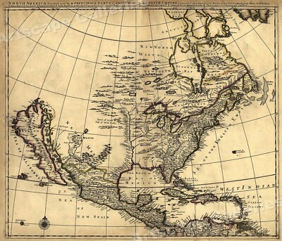
$5.95 Shipping Condition: New Location: Las Vegas, United States North America 1685 Size: 24" x 28" 61 cm x 86 cm) x Also Available in from our eBay Store This is a great Classic Map originally Published circa ... more1685. This Map shows what was known of America(North America) in1685. The wording reads: North America divided into its III principall parts. Features include: New North Wales" Canada) Bay of Mexico" Gulf of Mexico) Sea of the English Empire" Atlantic Ocean) West Indian Sea" Caribbean) Sea of California" Sea of New Spain" Pacific Ocean) New Mexico" Western United States) and"Tract of Land full of Wild Bulls" Great Plains) This poster. Which evokes the vivid images of a simpler time, is a custom reproduction printed on 68lb Heavyweight Enhanced Matte Art Paper. This Historic Art Print is suitable for framing. Mounting or direct display on any wall! 000 Artscape Galleries/ Posters Past More Prints and Posters Available from our eBay Store! Shipping price includes delivery confirmation. We combine shipping for multiple purchases- add $1.00 for each additional poster. All posters are professionally packaged to ensure that they arrive safely and undamaged: Your poster is first rolled and inserted into a plastic sleeve before being placed into a Heavy-Duty mailing tube for delivery. We stand behind the quality of every poster. If you are not satisfied with your purchase. Please contact us within 30 days to arrange for either an exchange or a full refund. gsrx_vers_468(GS 6.4(468)
Buy It Now
$5.95 Shipping Condition: New Location: Las Vegas, United States Year: 1823. This is a great Classic Map originally Published circa 1823. “Vibrant and bright! Pic does not do it justice.looks amazing!”. Each of our ... moreprints are custom reproductions printed on 68lb Heavyweight Enhanced Matte Art Paper.
Buy It Now
$5.95 Shipping Condition: New Location: Las Vegas, United States Carolina 1732. Year: 1732. A beautiful old map of the Carolina (North and South together). Shows the principal towns and rivers of the period. “Vibrant ... moreand bright! Pic does not do it justice.looks amazing!”.
Buy It Now
$20.40 Shipping Location: Newtown, United States Offering a vintage map of the United States. Originally created by Abel Buell in 1784. This old map is a more recent reproduction from the original at ... morethe New Jersey State Historical Society by American Heritage. Printed in Switzerland. The map measures 19" s 24". It has some yellowing, small markings, little tearing and creasing, that add to its historic look. Please see photos for details.
Buy It Now
$24.10 Shipping Location: Claypool, United States This piece of history belongs in the collection of any map or antique enthusiast, especially if from Fulton County. I have personally owned this item ... morefor over 40 years. All pages intact and in place.
Buy It Now
$11.85 Shipping Location: Dover, United States Issued 1797-1804, United States by Bradley. Map is perfect candidate for basic cleaning restoration but worthy of display as it survives.
Free Shipping Location: Carefree, United States FAIR CONDITION-DIOSCOLORATION(MOSTLY AT LEFT AND RIGHT SIDES OF MAP, CREASES AS ISSUED, MAP LOOKS MUCH BETTER THAN MY PICS. ).

Buy It Now
$5.95 Shipping Condition: New Location: Las Vegas, United States Title: nbsp Schönberg's map of Texas Subject: nbsp Classic Early Texas Map Year: nbsp 1866 Size: nbsp 24" x 28" As settlers spread ... morewest. Schönberg's map of Texas shows the growing state of Texas and the contemporary counties as of 1866. This map is a custom reproduction printed on 68lb Heavyweight Enhanced Matte Art Paper using Ultrachrome inks. Suitable for framing. Mounting or direct display, this print has a colorfast life of 125+ years. Example of Poster Detail       More Posters available from Artscape Galleries Online Shipping and Payment Information U.S. nbsp $4.95- USPS 1st Class   or   $6.95- Priority Mail Worldwide: nbsp Please Use the Shipping Calculator - nbsp                    (Both First Class International and Priority Mail International are available) Shipping price includes delivery confirmation. We combine shipping for multiple purchases- add $1.00 for each additional poster. All posters are professionally packaged to ensure that they arrive safely and undamaged: nbsp Your poster is first rolled and inserted into a plastic sleeve. That sleeve is then placed into a Heavy-Duty mailing tube and securely sealed. Pay me securely with any major credit card through PayPal! nbsp 30 Day Money Back Guarantee! nbsp Artscape Galleries stands behind the quality of every poster. If you are not satisfied with your purchase. Please contact us within 30 days to arrange for either an exchange or a full refund. Posters Pictures Classic Vintage Style Art Print Paintings Decorative Decorations Decor Artist Classic American Large Restored Antique Print Old Print Classic Canvas Impressionist Replica Historic Classic Travel Poster Antique Map Poster Civil War Map Military Map Republic of Texas Texas Territory Great Plains Old West_gsrx_vers_468(GS
Buy It Now
$10.75 Shipping Location: Centreville, United States This antique map from 1863 depicts the Gettysburg Campaign and is in mint condition. The map is a historical watercolor reproduction and features detailed ... moreinformation of the theater of the war. The map is perfect for collectors of antique maps and those interested in the history of the Civil War. Its format is an atlas map, and it is a valuable addition to any collection of North America maps. Don't miss out on the opportunity to own this historic piece.
Free Shipping Condition: Used Location: Hemet, United States Have not looked into it and read the material. Of Danvers,Mass. Putnam in 1800. In nice brown ink. As well as the dial compass and directions of lots ... moreof land here in Danvers,Mass. 224 years ago!
$6.00 Shipping Location: Corunna, United States This is an original 109 year old map, not a copy or reprint.

Buy It Now
$5.95 Shipping Condition: New Location: Las Vegas, United States Map of Florida 1823 Size: 20" x 24" 51 cm x 61 cm) x Also Available in 24" x 28" from our eBay Store This is a great Classic Map originally ... morePublished circa 1823. This map by Charles Blacker Vignoles. Shows Florida and the Gulf of Mexico in the early 1800's. This poster. Which evokes the vivid images of a simpler time, is a custom reproduction printed on 68lb Heavyweight Enhanced Matte Art Paper. This Historic Art Print is suitable for framing. Mounting or direct display on any wall! 000 Artscape Galleries/ Posters Past More Prints and Posters Available from our eBay Store! Shipping price includes delivery confirmation. We combine shipping for multiple purchases- add $1.00 for each additional poster. All posters are professionally packaged to ensure that they arrive safely and undamaged: Your poster is first rolled and inserted into a plastic sleeve before being placed into a Heavy-Duty mailing tube for delivery. We stand behind the quality of every poster. If you are not satisfied with your purchase. Please contact us within 30 days to arrange for either an exchange or a full refund. gsrx_vers_468(GS 6.4(468)
Free Shipping Location: Lakeview, United States Some staining Appears to be printed on linen Great historical piece
Buy It Now
$5.95 Shipping Condition: New Location: Las Vegas, United States La Floride (Florida). Year: 1657. A nice early map of Florida c.1657. “Vibrant and bright! Pic does not do it justice.looks amazing!”. Each of our prints ... moreare custom reproductions printed on 68lb Heavyweight Enhanced Matte Art Paper.
Buy It Now
$5.95 Shipping Condition: New Location: Las Vegas, United States This is an early (1837) map of the Republic of Texas, showing the land grants that make up the territory. Featured Land Grants and Points of Interest ... moreare Year: 1837. Map of Texas with Parts of the Adjoining States / Compiled by Stephen F. Austin.
Buy It Now
$10.00 Shipping Location: Katy, United States AndTexas Joins the Union. All have been hand drawn and digitally reproduced.
Buy It Now
$4.55 Shipping Location: Oakland, United States This antique map of North America from 1869 is a rare find for collectors of historical cartography. Measuring 8.5 x 7 inches, the map features detailed ... moreborders, topography, and cities of the time period. The map is in excellent vintage condition and would make an impressive addition to any collection.The map is perfect for those interested in the history of North America or antique maps in general. Whether displayed in a home, office, or gallery, this piece is sure to spark conversations and admiration. Don't miss your chance to own a piece of history with this antique 1869 map of North America.
Buy It Now
$4.65 Shipping Location: Saco, United States Page will have normal wear, browning and slightly rough or torn edges. No Book Killer Here! Plenty of border for matte and framing. No Copies or Reprints!
Buy It Now
$6.95 Shipping Location: Dover, United States Issued 1861, New York by Hayward. A Map of the Common Lands Between the Three and Six Miles Stones Belonging to the Corporation of the City of New York. ... moreMap will look nice if displayed. Mid 19th century Civil War era lithographed historical map with original hand color.
Buy It Now
$8.57 Shipping Location: Celina, United States Maps are in good condition with some tears see pictures, pages and binding in good condition with some foxing, cover and back cover are either off or ... morecoming off both volumes
Buy It Now
$11.85 Shipping Location: Dover, United States Issued 1868, New York. Litho by W.V. Rogers & Co for Joseph Shannon.
Buy It Now
$22.78 Shipping Location: Dover, United States A genuinely fascinating historical map in a near wall size format. Very uncommon scarce mid 19th century folio sheet lithographed map with original hand ... morecolor. Decorative piano key border. From a rare atlas of this era.
$6.00 Shipping Location: Blue Bell, United States THIS MAP IS IN GOOD CONDITION BY OLNEY. CONDITION: MAP IS IN GOOD. OVER 100 YEARS OLD! Over 100,000,000 served. MULTIPLE WINS.
Buy It Now
$4.55 Shipping Location: Oakland, United States This antique colorful map from 1889 is a great find for any historian interested in the history of the US State of New Mexico. It's a detailed and beautiful ... morepiece of art that measures 13x10 inches and shows the state of New Mexico and part of Texa. The colors used to create the map are vibrant and eye-catching, and the details are intricate and stunning. The map is sure to make a great addition to any room, whether you're looking for a unique piece of art or a historical artifact to display.
Buy It Now
$5.95 Shipping Condition: New Location: Las Vegas, United States Year: 1747. This map, by Joan Vinckeboons, shows the northeast coast of the United States from New England to Virginia, including coastal features and ... moreother geographical entities. A New and Accurate Map of New Jersey, Pensilvania, New York and New England.
Buy It Now
$5.95 Shipping Condition: New Location: Las Vegas, United States This is a great Classic Map originally Published circa 1757. Year: 1757. “Vibrant and bright! Pic does not do it justice.looks amazing!”. Beautiful map! ... moreEach of our prints are custom reproductions printed on 68lb Heavyweight Enhanced Matte Art Paper.
Buy It Now
$5.95 Shipping Condition: New Location: Las Vegas, United States This is a great Classic Map originally Published circa 1757. “Vibrant and bright! Pic does not do it justice.looks amazing!”. Beautiful map! Each of our ... moreprints are custom reproductions printed on 68lb Heavyweight Enhanced Matte Art Paper.
Buy It Now
$5.95 Shipping Condition: New Location: Las Vegas, United States Year: 1718. Map of Louisiana Territory and the Mississippi. Shows the course of the Mississippi river. Notes of interest include Indian territories (Apache, ... morePadouca, Iroquois, Sioux). “Vibrant and bright!
Buy It Now
$6.95 Shipping Location: Dover, United States Issued 1875, New York by F.W. Beers. Very detailed mid-19th century lithographed map with original hand color. Of great interest for historical genealogical ... morepurposes.
Buy It Now
$33.29 Shipping Location: Omaha, United States An Historical and Geographical Map of the State of Kentucky "The Dark And Bloody Ground". Artist : Karl Smith. A later version was issued in 1939 with ... morea horse scene at the center, below the neatline.
Buy It Now
$6.50 Shipping Location: Evansdale, United States For sale is an Original Engraved High Quality 1875 Iowa Map! Size: 14.5" x 17.5" - Good condition - Ready for Framing! Normal signs of wear. A page taken ... morefrom a previously destroyed copy of the 1875 The Illustrated Historical Atlas of the State of Iowa A.T. Andreas.
Buy It Now
$5.95 Shipping Condition: New Location: Las Vegas, United States Year: 1814. State of Louisiana. Each of our prints are custom reproductions printed on 68lb Heavyweight Enhanced Matte Art Paper. These Historic Art Prints ... moreare suitable for framing, mounting or direct display on any wall!
$6.00 Shipping Location: Corunna, United States This is an original 109 year old map, not a copy or reprint.
Buy It Now
$5.95 Shipping Condition: New Location: Las Vegas, United States Carolina 1732. Year: 1732. A beautiful old map of the Carolina (North and South together). Shows the principal towns and rivers of the period. “Vibrant ... moreand bright! Pic does not do it justice.looks amazing!”.
Buy It Now
$5.95 Shipping Condition: New Location: Las Vegas, United States Year: 1884. Cedar Key 1884. De Land 1884. Key West 1884. These Historic Art Prints are suitable for framing, mounting or direct display on any wall! Key ... moreWest, Florida. “Vibrant and bright! Pic does not do it justice.looks amazing!”.
Buy It Now
$5.40 Shipping Location: Corunna, United States This is an original 125 year old map, not a copy or reprint.
$5.95 Shipping Location: Grimes, United States This is a unique antique map of the United States, crafted from embroidered cross stitch in the 1940s.
$6.00 Shipping Location: Corunna, United States This map is from A New General Atlas Exhibiting The Five Great Divisions of the Globe drawn and engraved by M. Malte-Brun. Atlas was published by Grigg ... more& Elliot Philadelphia 1832. This is an original 192 year old map, not a copy or reprint.
Buy It Now
$5.95 Shipping Condition: New Location: Las Vegas, United States “Vibrant and bright! Pic does not do it justice.looks amazing!”. Each of our prints are custom reproductions printed on 68lb Heavyweight Enhanced Matte ... moreArt Paper. These Historic Art Prints are suitable for framing, mounting or direct display on any wall!
Buy It Now
$5.55 Shipping Location: Daly City, United States Neat display map showing historic sites (buildings) with history of the Sonoma Valley, Thanks for viewing
$6.00 Shipping Location: Corunna, United States This is an original 109 year old map, not a copy or reprint.
Buy It Now
$5.95 Shipping Condition: New Location: Las Vegas, United States 1660 Map of New York (New Amsterdam - Manhattan). Year: 1660 (redrafted in 1916). Each of our prints are custom reproductions printed on 68lb Heavyweight ... moreEnhanced Matte Art Paper. These Historic Art Prints are suitable for framing, mounting or direct display on any wall!
Buy It Now
$12.45 Shipping Location: Chicago, United States For your consideration, a historical map of Manhattan entitledA Map of the Common Lands Between the Three and Six Mile Stones. This item is from an estate ... moreand is in as-found condition. I believe this map was published in 1861, but I have no way to prove this.
$6.00 Shipping Location: Blue Bell, United States THIS MAP IS IN GOOD CONDITION BY RAND MCNALLY. CONDITION: MAP IS IN GOOD. OVER 100 YEARS OLD! Over 100,000,000 served. MULTIPLE WINS.
Buy It Now
$6.00 Shipping Location: Corunna, United States This map is from Mitchell's New General Atlas published in Philadelphia 1864. This is an original 160 year old map, not a copy or reprint.
Buy It Now
$5.95 Shipping Condition: New Location: Las Vegas, United States Year: 1661. Haemisphaerium Sceno Graphicum - Celestial Chart of the Zodiac. A beautiful and unique celestial chart by Henricus Hondius. Shows signs of ... morethe zodiac above “Australis Incognito” (Australia unknown) and the Southern Hemisphere.
$6.00 Shipping Location: Corunna, United States This is an original 109 year old map, not a copy or reprint.
Buy It Now
$5.95 Shipping Condition: New Location: Las Vegas, United States Omaha 1868. Nebraska City 1868. Year: 1868. Omaha, Nebraska. These Historic Art Prints are suitable for framing, mounting or direct display on any wall! ... more“Vibrant and bright! Pic does not do it justice.looks amazing!”.
Buy It Now
Free Shipping Location: Waterloo, United States Historical Fold Out Map To New York City in 1924 Antique NY Map by the Ask Mr Foster series. Published by Foster & Reynolds Co.
Buy It Now
$19.45 Shipping Location: Bellefonte, United States "1901 Geological Map of New York, Finger Lakes Sheet". Very Good+ Condition, (LAMINATED) & Highly Detailed. 15 N Water St, Lewisburg, PA 17837. It initially ... moreserved as a tavern and inn for river travelers along the Susquehanna.
|
|
|
In
|
1962 Rucker Agee on 10 MOST IMPORTANT HISTORIC CARTOGRAPHERS of American Maps
by adding my Store to your Favorites- see MAP items not always found with search Here's a link to my currently available MAP/CARTOGRAPHY items: ++++++++ CARTOGRAPHERS? WHO ARE THE TOP TEN? by Rucker Agee Birmingham. Alabama: Sterne& Agee] 1962; pp 8, typed single space and mimeographed, stapled into plain cover- AS ISSUED. 8½ x 11 inch format. This is vintage. Original 1962 mimeograph- NOT any kind of modern day copy done on a xerox or computer printer. Printed on vintage, porous mimeo bond paper resulting in the original mimeo ink ABSORBING INTO THE PAPER- not laying on top of the paper the way xerox copying does. Noted Birmingham Alabama map collector gives his expert opinion on the top ten mapmakers of all time: Ptolemy(Ptolemaus) Gastaldi Ortelius Mercator Hondius Blaeu Sanson DeLisle D'Anville Arrowsmith with a ca. half ... morepage historical sketch of each one. Agee contributed this essay to the Zipp Newman newspaper column in Birmingham back in 1962 and then had copies mimeographed and bound(in a simple fashion) for a few friends and fellow collectors. FINE. the fine print. sigh] but please read: WE REGRET WE DON'T SHIP OUT OF USA; SORRY. BUT NO EXCEPTIONS. FREE SHIPPING via cardboard& plastic-protected 1st class mail. PAYPAL IS THE MUCH PREFERRED METHOD OF PAYMENT. Thanks! Please pay within 4 days. Delayed? Then email me- I'll try to work with you when necessary but it helps a lot when I have contact with you. If your payment is delayed. Ebay is liable to send a dun or two. PLEASE NOTE THAT THOSE ARE COMING AUTOMATICALLY FROM EBAY AND NOT FROM ME. I typically send out just one reminder. PLACING A BID IS THE ETHICAL EQUIVALENT OF ACCEPTING THESE TERMS. PLEASE DON'T ASK TO ALTER THEM AFTERWARDS. In return. As our feedback clearly shows, we'll get your item(s) to you, as described, in a safe, timely manner. Thanks! editorials: Want a"FIRST EDITION" of TO KILL A MOCKINGBIRD
|
|
|
Virginia Panoramic Antique Maps CD 16 Historic Maps
Virginia Panoramic Antique Maps CD 16 Historic Maps Virginia Panoramic Map Collection on CD The panoramic map was a popular cartographic form used to depict U.S. and Canadian cities and towns during the late nineteenth and early twentieth centuries(1847 to 1929. Known also as bird's-eye views. Perspective maps, and aero views, panoramic maps are non-photographic representations of cities portrayed as if viewed from above at an oblique angle. Although not generally drawn to scale, they show street patterns, individual buildings, and major landscape features in perspective. Panoramic maps graphically depict the vibrant life of a city. Harbors are shown choked with ships. Often to the extent of constituting hazards to navigation. Trains speed along railroad tracks, at times on the same roadbed with locomotives and cars headed in the opposite ... moredirection. People and horse drawn carriages fill the streets, and smoke belches from the stacks of industrial plants. Urban and industrial development in post-Civil War America is vividly portrayed in the maps. These maps are high resolution JPG images on CD. There is no software to install in order to view these maps. You can view. Edit, or print them using your favorite picture viewer or browser. This collection of maps are high quality digital reproductions on CD. Listed below are the maps that are included in this collection. Alexandria VA 1863 Bedford VA 1891 Buena Vista VA 1891 Emporia VA 1907 Franklin VA 1907 Fredericksburg VA 1863 Newport News VA 1891 Norfolk Portsmouth VA 1873 Norfolk VA 1892 Pocahontas VA 1911 Richmond VA 1863 Roanoke VA 1891 Staunton VA 1891 University of Virginia 1856 Waynesboro VA 1891 Winchester VA 1826 This auction is for a CD of the maps listed in electronic form. NOT the physical maps themselves. Click Images to Enlarge Payment should be received within 3 business days of the close of the auction. If you are unsatisfied for any reason with your purchase. Please contact us within 14 days for a refund of your purchase. Our CD and DVD items wil
|
|
|
Antique Historic Panoramic Maps of AZ NV NM & UT on CD
Antique Historic Panoramic Maps of AZ NV NM& UT on CD 13 Panoramic Maps of Arizona. Nevada, New Mexico, and Utah on CD The panoramic map was a popular cartographic form used to depict U.S. and Canadian cities and towns during the late 19th and early 20th centuries. Known also as bird's-eye views. Perspective maps, and aero views, panoramic maps are non-photographic representations of cities portrayed as if viewed from above at an oblique angle. Although not generally drawn to scale, they show street patterns, individual buildings, and major landscape features in perspective. Virginia City. NV 1875 Preparation and sale of nineteenth-century panoramas were motivated by civic pride and the desire of the city fathers to encourage commercial growth. Many views were prepared for and endorsed by chambers of commerce and other civic organizations ... moreand were used as advertisements of a city's commercial and residential potential. Panoramic maps graphically depict the vibrant life of a city. People and horse drawn carriages fill the streets. And smoke belches from the stacks of industrial plants. Urban and industrial development in post-Civil War America is vividly portrayed in the maps. No other graphic form of this era so effectively captured the vitality of America's urban centers. Salt Lake City. UT 1891 at(5X Zoom) Panoramic maps give a pictorial record of America's cities during the post-Civil War period and for many localities provide the sole nineteenth-century map. I n their original paper form. These maps were very large(3 feet X 4 feet, or even larger) The maps are saved in a file format which uses a compression ratio of up to 22:1. These extremely high-resolution maps contain an amazing level of detail and most image viewers are not able to decode this special format, so a special program is required to view and manipulate the images and is included on the CD. This software has an incredibly powerful zoom feature(14 levels) that will allow you to see the entire map. And you can also zoom down
|
|
|
Vermont Panoramic Antique Maps CD 23 Historic Maps
Vermont Panoramic Antique Maps CD 23 Historic Maps Vermont Panoramic Map Collection on CD The panoramic map was a popular cartographic form used to depict U.S. and Canadian cities and towns during the late nineteenth and early twentieth centuries(1847 to 1929. Known also as bird's-eye views. Perspective maps, and aero views, panoramic maps are non-photographic representations of cities portrayed as if viewed from above at an oblique angle. Although not generally drawn to scale, they show street patterns, individual buildings, and major landscape features in perspective. Panoramic maps graphically depict the vibrant life of a city. Harbors are shown choked with ships. Often to the extent of constituting hazards to navigation. Trains speed along railroad tracks, at times on the same roadbed with locomotives and cars headed in the opposite ... moredirection. People and horse drawn carriages fill the streets, and smoke belches from the stacks of industrial plants. Urban and industrial development in post-Civil War America is vividly portrayed in the maps. These maps are high resolution JPG images on CD. There is no software to install in order to view these maps. You can view. Edit, or print them using your favorite picture viewer or browser. This collection of maps are high quality digital reproductions on CD. Listed below are the maps that are included in this collection. Barre VT 1884 Bellows Falls VT 1886 Bennington VT 1887 Bethel VT 1886 Brandon VT 1890 Brattleboro VT 1886 Bristol VT 1889 Castleton VT 1889 Enosburg Falls VT 1892 Fair Haven VT 1886 Hardwick VT 1892 Ludlow VT 1885 Lyndonville VT 1884 Middlebury VT 1886 Montpelier Vt 1884 Morrisville VT 1889 Puoltney VT 1886 Rutland VT 1885 Saint Johnsbury VT 1884 Springfield VT 1886 Vergennes VT 1890 West Randolph VT 1886 Wilmington VT 1891 This auction is for a CD of the maps listed in electronic form. NOT the physical maps themselves. Click Images to Enlarge Payment should be received within 3 business days of the close of the auction. If you are unsatisfied for any
|
|
|
44 Antique Historic Panoramic Maps of Michigan MI on CD
44 Antique Historic Panoramic Maps of Michigan MI on CD 44 Panoramic Maps of Michigan on CD The panoramic map was a popular cartographic form used to depict U.S. and Canadian cities and towns during the late 19th and early 20th centuries. Known also as bird's-eye views. Perspective maps, and aero views, panoramic maps are non-photographic representations of cities portrayed as if viewed from above at an oblique angle. Although not generally drawn to scale, they show street patterns, individual buildings, and major landscape features in perspective. Lansing. MI 1866 Preparation and sale of nineteenth-century panoramas were motivated by civic pride and the desire of the city fathers to encourage commercial growth. Many views were prepared for and endorsed by chambers of commerce and other civic organizations and were used as advertisements ... moreof a city's commercial and residential potential. Panoramic maps graphically depict the vibrant life of a city. People and horse drawn carriages fill the streets. And smoke belches from the stacks of industrial plants. Urban and industrial development in post-Civil War America is vividly portrayed in the maps. No other graphic form of this era so effectively captured the vitality of America's urban centers. Detroit. MI 1889 at(6X Zoom) Panoramic maps give a pictorial record of America's cities during the post-Civil War period and for many localities provide the sole nineteenth-century map. I n their original paper form. These maps were very large(3 feet X 4 feet. Or even larger) The maps are saved in a file format which uses a compression ratio of up to 22:1. These extremely high-resolution maps contain an amazing level of detail and most image viewers are not able to decode this special format, so a special program is required to view and manipulate the images and is included on the CD. This software has an incredibly powerful zoom feature(14 levels) that will allow you to see the entire map. And you can also zoom down to street level. You'll be able to save
|
|
|
Maine Panoramic Antique Maps CD 28 Historic Maps
Maine Panoramic Antique Maps CD 28 Historic Maps Maine Panoramic Map Collection on CD The panoramic map was a popular cartographic form used to depict U.S. and Canadian cities and towns during the late nineteenth and early twentieth centuries(1847 to 1929. Known also as bird's-eye views. Perspective maps, and aero views, panoramic maps are non-photographic representations of cities portrayed as if viewed from above at an oblique angle. Although not generally drawn to scale, they show street patterns, individual buildings, and major landscape features in perspective. Panoramic maps graphically depict the vibrant life of a city. Harbors are shown choked with ships. Often to the extent of constituting hazards to navigation. Trains speed along railroad tracks, at times on the same roadbed with locomotives and cars headed in the opposite direction. ... morePeople and horse drawn carriages fill the streets, and smoke belches from the stacks of industrial plants. Urban and industrial development in post-Civil War America is vividly portrayed in the maps. These maps are high resolution JPG images on CD. There is no software to install in order to view these maps. You can view. Edit, or print them using your favorite picture viewer or browser. This collection of maps are high quality digital reproductions on CD. Listed below are the maps that are included in this collection. Augusta ME 1878 Bangor ME 1875 Bar Harbor ME 1886 Blue Hill ME 1896 Bridgton ME 1888 Cherryfield ME 1896 Dixfield ME 1896 Eastport ME 1879 Gardner Pittston ME 1878 Hallowell ME 1878 Houlton ME 1894 Kennebunk ME 1895 Kingfield ME 1895 Livermore Falls ME 1889 Machias ME 1896 Monhegan ME 1896 Monson ME 1889 New Berwick ME 1877 New Castle ME 1878 Peaks Island ME 1886 Pittsfield ME 1889 Portland ME 1876 Presque Isle ME 1894 Richmond ME 1878 Sanford ME 1889 South Berwick ME 1877 Wilton ME 1895 Wisscasset ME 1878 This auction is for a CD of the maps listed in electronic form. NOT the physical maps themselves. Click Images to Enlarge Payment should be received wi
|
|
|
159- Lot of 20 Historic Topographic Maps for Pennsylvania (PRR) - READ!
This is a lot of 20 historic topographic maps from Pennsylvania. They came from the collection of a guy who was interested in the Pennsylvania Railroad(PRR) and I believe the railroad is shown in all 20 maps. The individual maps and dates are: Columbia East. 1956 Fawn Grove( MD) 1956 Hamburg. 1956 Gettysburg. 1951 Honey Brook. 1955 Manheim. 1955 Morgantown. 1956 Stewartstown. 1953 Terre Hill. 1956 Unionville. 1953 Elverson. 1956 Wakefield. 1955 Belvidere( NJ) 1955 Boyertown. 1957 New Holland. 1956 Parkesburg. 1953 Safe Harbor. 1955 Quarryville. 1955 Marcus Hook( DE and MD) 1953 Columbia West. 1964 Only a few are shown as you really can't make out the detail anyway. All are in similar condition. Payment by PayPal only. Shipping to continental USA only. Shipping will be combined across all lots with no additional charge. Shipping will be ... morea flat fee of $10. Shipping price accounts for mailing tube.
|
|
|
54 Historic Revolutionary War Maps of New Jersey NJ on CD - B63
The Historical Archive Sample Page Revolutionary War Era Maps of New Jersey This CD contains 54 rare antique maps and descriptive pages representing fascinating details about New Jersey and its vicinity during the Revolutionary War in MrSid format. T his format allows you to see the entire map on your computer screen or drill down to see the smallest details. The original maps are often quite large. As much as 36" long or larger and quite detailed. With the MrSID software, you can manipulate the map to print the entire map in great detail or zoom into a portion of the map in full detail for viewing or printing. You could even bring the images to a local print shop to have the maps reprinted in their full size. MrSID software is included on the CD. To give you a sample of the detail you can expect in these maps. Here is an example based ... moreon a panoramic map of Washington, DC. The table below shows the description and a small image of each map on this incredible history CD. Map of the coast of New Jersey from Barnegat Inlet to Cape May. CREATED/PUBLISHED 177- NOTES Scale ca. 1:32.000. Manuscript, pen-and-ink. Oriented with north to the right. Relief shown by shading. Soundings shown in fathoms. Shows the coast and the Mullica River inland to the site of the"Batsto forge. Indexed for points of interest. Sketch of the road from Black Horse to Crosswick. By I. Hills, June 1778. Sketch of Allens Town, June 1778. Hills, John, surveyor. CREATED/PUBLISHED[1778] NOTES Scale ca. 1:26,000 and ca. 1:16,000; 800 paces to an in. not 400 paces to an in. and 400 paces to an in. Manuscript, pen-and-ink and watercolor. Has watermarks. Sketch of the road from Black Horse to Crosswick. Sketch of Allen's Town. By] I. H. Hills. John, surveyor. CREATED/PUBLISHED 1778. NOTES Scale ca. 1:26,000; 800 paces to the in. Manuscript, pen-and-ink and watercolor. Has watermarks. Relief shown by shading. Plan of the road from Elizabeth Town Point to Elizabeth Town shewing the rebel works raised for its defence. Survey'd by I. Hills
|
|
|
3 Vintage Rhode Island Maps - 1936 - 1938 - 19?? - Historic - Nice Items Look.
Here is a lot of 3 vintage maps that I purchased here on Ebay. While researching the history of Rhode Island. All maps are complete, with no writing, and very little signs of age. 1 Rhode Island"Tricentenary" is dated 1936, 1 Socony 1938, and 1 Gulf from which I beleive to be late 40's to mid 50's. Priced at about 1/2 of what I paid.
|
|
|
Vintage Colorado Recreation Guide with Maps Sixth edition 1978 Historic (65 ea)
Vintage Colorado Recreation Guide(192 pages) with 65 loose foldout Maps. This is the sixth edition printed in 1978. Maps are numbered 1-65 double sided. With additional Travel Map highlighting State Parks and Recreation Areas. Includes popular areas throughout the state. A must for the Colorado and outdoor lover. Maps are slightly yellowed on the edges. This is a very comprehensive guide that includes: Game Units Ice Fishing Fishing Birds Small Game Big Game Boating And more! A must for Hiking. Hunting, Fishing, Jeeping, 4X4ing. Camping. Sight Seeing. Maps are keyed with Ghost Towns, Points on Interest, Rock Hunting, Lost Treasures, Fossil Hunting.
|
|
|
HISTORIC 1882 ATLAS, H H HARDESTY MANY COPPER PLATE UNITED STATES MAPS HISTORY
H. H. HARDESTY 1882 ATLAS OLD ANTIQUE COPPER PLATE MAPS. HISTORY OF VIRGINIAS AND WOOD COUNTY. ACTUAL ACCOUNTINGS OF HISTORY OF THE PEOPLE AND EVENTS OF THE TIME. THE MAPS ARE OF EACH STATE AND ARE TAPED IN; THEN THE TAPE IS SEWN INTO THE BINDING. SO THEY ARE REMOVABLE TO BE DISPLAYED. THERE ARE 43 STATE MAPS AND 1 US MAP. ALSO 12 WORLD MAPS. THERE ARE MANY OLD WOOD BLOCK ETCHINGS OF AMERICAN SCENES AND PEOPLE. THERE ARE MANY ETCHINGS OF WORLD HISTORICAL SITES. PLEASE READ CONDITION BEFORE BIDDING THANK YOU CONDITION: THE CONDITION IS POOR TO FAIR FOR A 100 PLUS YEAR OLD ATLAS! THE BINDING IS FALLING APART. THE PAGES ARE YELLOW AND THERE IS SOME FOXING, THE EDGES OF PAGES ARE BRITTLE SOME CRACKING AND DAMAGE TO THE COVER AS SEEN IN THE PICTURES, THIS IS NOT A PERFECT BOOK CONDITION IS POOR FOR A BOOK, BUT THE HISTORY AND MOST MAPS ARE FANTASTIC! ... moreFOLD OUT MAPS ARE FOLDED IN QUARTERS. THEY ARE VERY BRITTLE AND DO HAVE MANY CRACKS AND TEARS. THE TWO PAGE STATE MAPS ARE IN GREAT CONDITION WITH MINOR EDGE CRACKS. PLEASE SEE PHOTOS AND MAKE YOUR OWN JUDGEMENT, THANK YOU FOR LOOKING AT THIS GREAT PIECE OF HISTORY Powered by The free listing tool. List your items fast and easy and manage your active items.
|
|
|
INVESTING IN MAPS BAYNTON-WILLIAMS 1969 & HISTORIC MARITIME MAPS DONALD WIGAL
PUBLISHER;VARIOUS EXTRA INFO; MARITIME IS NICELY ILLUSTRATED IN COLOR. B& W IN THE OTHER. INVENTORY 30B ALL ITEMS ARE SHIPPED BY USPS. NEED SPECIAL SHIPPING. CONTACT US BEFORE PURCHASING. 2fiuqm.RcmdId ViewItemDescV4,RlogId p4%60bo7%60jtb9%3Fuk%601d72f%2Bifc%3E2fiuqm-13de8d64434-0xf9-
|
|
|
195- Historic Topographic Maps for MD (PRR) - READ!
This is a pair of historic topographic maps from Maryland that the original owner spliced together. They came from the collection of a guy who was interested in the Pennsylvania Railroad(PRR) The lower portion is labeled Owensville and bears the dates of 1890. 1900, 1904. It shows the west edge of the Chesapeake Bay, the South River and the West River. The upper portion appears to be an exact match. But the label cannot be read as it is glued to the lower portion. It shows the Severn River, the Magothy River, and up to the Potapsco River. Payment by PayPal only. Shipping to continental USA only. Shipping will be combined across all lots with no additional charge. Shipping will be a flat fee of $10. Shipping price accounts for mailing tube.
|
|
|
158- Lot of 5 Historic Topographic Maps for PA, DE, MD (PRR) - READ!
This is a lot of 5 historic topographic maps from Pennsylvania and New Jersey. They came from the collection of a guy who was interested in the Pennsylvania Railroad(PRR) and I believe the railroad is shown in all 5 maps. The individual maps and dates are: Media PA. 1955 Kirkwood PA. 1955 Newark West MD DE PA. 1953 Bay View MD PA. 1953 Rising Sun MD PA. 1953 Only a few are shown as you really can't make out the detail anyway. All are in similar condition. Payment by PayPal only. Shipping to continental USA only. Shipping will be combined across all lots with no additional charge. Shipping will be a flat fee of $10. Shipping price accounts for mailing tube.
|
|
|
National Geographic Maps 2 Covering Classical/Historic Mediterranean(1949 & 1982
Listed here are 2 original National Geographic maps. One from 1949 entitled The Classical Lands of the Mediterranean(The Greco-Roman World) and the second from 1982 entitled The Historic Mediterranean which is a two-sided map. Both maps are in very good condition with no damage, writing at any point or tears. The Classical Lands map is 21-3/4 x 32 inches in size while the other is 37 x 22-1/2 inches. We will combine multiple lots won if reasonably possible. Any questions please contact us.
|
|
|
Historic City Maps - NEW YORK CITY PLANNING MAP BY B RATZEN 1767
This is an exquisite full-color Reproduction printed on heavyweight(7.0 MIL) Glossy Photo Paper. These maps are perfect for framing. Or a wonderful and unique gift for family members, friends or co-workers! All Information is Carefully Compiled from Actual Surveys Original Maps are often difficult to find and usually have fold lines. Identifying stamps or markings, tears, ragged edges, and assorted other natural signs of age that detract from their beauty. All of our maps have been professionally restored to depict their original beauty, while keeping all historical data intact. These maps are fabulous pieces of history full of information useful to Historians. Genealogists, Cartographers, Relic Hunters, Others. They make fascinating conversation pieces and splendid works of art for the home or office. Map Size: 23.00 x 33.05 Site Specifics ... moreTo This Map Are: New York. Manhattan, and Brooklyn. The following towns are featured: a table of references including Fort George. Trinity Church, St Pauls Church, St George's Chapel, Old Dutch Church, New Dutch Catholic Church, Presbyterian Meeting, French Church, Lutheran Church, Calvinist Church, Quaker's Meeting, Jews Synagogue, The College, Free English School, Secretary's Office, City Hall, The Prison, Poor House, Barracks, Old Ship, and others. Waterways shown include East or Sound River and North or Hudson River. The Brookland Ferry, Ramfen's Mill, Crown Point or Corlar's Hook, Paulias Hook Ferry, and the ward divisions are clearly notated. This Map is Situated in: New York County. New York(NY) SKU: NYNY0001 and Powered By:
|
|
|
GO324. Poland 8v historic maps & transportation COMBINE SHIPPING
WE ALWAYS COMBINE SHIPPING FOR SAVE POSTAGE EXPENSES Dear friend Thanks for your interest in this item. We always combine shipping for save postage expenses"Shipping and handling" to worldwide up to 100 gr- $ 4.0 100gr- approximately to 1- 15 stamps items. Or 1-14 different covers, FDC, MCards, Bkl. 16- 35 stamps items. 15-35 different covers, FDC, MCards, Bkl- $ 8 Maybe. You will become interested also in other ours items. PLEASE. IF YOU HAVE BOUGHT MORE THAN ONE ITEM, WAIT COMBINED"TOTAL INVOICE" I wish you a successful and smooth shopping on EBAY. Best regards Mrs. Galina P.S. If the total amount of your purchases $ 150 or more- Shipping FREE SAVE POSTAGE COSTS! Authenticity of all positions exposed on sale. Is checked up by the seller Powered by The free listing tool. List your items fast and easy and manage your active ... moreitems.
|
|
|
Vtg Gazette Sandhills Area Golfing Guide directory Index maps tour historic golf
Vintage. The Gazette Sandhills Area Golfing Guide directory, Index, maps, tour, historic infomation& pics published 1990.31 pages.Horizontal fold at mddle. Shipping for USA is $5.95. Canada is $5.95. International residents please email for quote. Paypal accepted. Email if you have any questions or visit my store for other great vintage& antique golf items at ThePastOnline.com or PastOnline. The premiere place for golf collectibles. Click here for my other Auctions. S&H and Payment policies Click here for my eBay Store to browse through all the items I am selling! Powered by The free listing tool. List your items fast and easy and manage your active items.
|
|
|
1745 RUSSIAN ATLAS - {20 Historic Maps of Russia} Book on CD
New Page 1 1745 ATLAS OF RUSSIA MAPS ON CD-ROM DESCRIPTION Russian Atlas entitled"Russischer Atlas. Welcher in einer general-Charte und neunzehen special-Charten das gesamte russische Reich und dessen angräntzende Länder, nach den Regeln der Erd-Beschreibung und den neuesten Observationen vorstellig macht. Published in 1745. Text in German. Maps titles in Latin and place names in Russian in the Latin alphabet. 25 pages consisting of 20 maps. Ultra-high resolution maps in Adobe PDF format. Packaged in a gift quality. Professionally labeled CD or DVD. SAMPLE PAGES These images are for illustration purposes only. The product you receive is of much higher quality and will not be watermarked. Powered by The free listing tool. List your items fast and easy and manage your active items.
|
|
|
" 1 CANVAS, DENOYER AND GEPPERT PULL DOWN MAPS HISTORIC OREGON COUNTRY "
DENOYER AND GEPPERT" PULL DOWN SCHOOL MAP.HISTORIC OREGON COUNTRY) 46" TALL BY 43" WIDE. THIS MAP IS IN GREAT SHAPE. IT'S TOPIC IS ABOUT WHEN OREGON BOUNDARY USED TO GO FROM CANADA BORDER DOWN TO MEXICO AND FROM WEST OF THE ROCKIES. REAL INTERESTING MAP. WITH A LOT OF DETAILS ABOUT THE HISTORY. THANKS FOR YOUR INTERESTS IN THIS ITEM.
|
|
|
157- Lot of 13 Historic Topographic Maps for PA, DE, MD, NJ (PRR) - READ!
This is a lot of 13 historic topographic maps from Pennsylvania. Maryland, Delaware and New Jersey. They came from the collection of a guy who was interested in the Pennsylvania Railroad(PRR) and I believe the railroad is shown in all 13 maps. The individual maps and dates are: Elkton MD DE. 1992 Aberdeen MD. 1955/1985 Northeast MD. 1992 Havre De Grace. 1998 Kennett Square PA DE. 1993 Kirkwood PA. 1955/1990 West Grove PA DE. 1990 Rising Sun PA MD. 1998 Oxford PA. 1999 Newark West PA DE MD. 1992 Newark East DE. 1993 Wilmington South MD DE. 1997 Bay View MD PA. 1997 Only a few are shown as you really can't make out the detail anyway. All are in similar condition. Payment by PayPal only. Shipping to continental USA only. Shipping will be combined across all lots with no additional charge. Shipping will be a flat fee of $10. Shipping price ... moreaccounts for mailing tube.
|
|
|
GREECE Six Detailed Maps of Aegean Thrace for Philatelic or Historic Research
Greece- six very detailed maps of Greek Aegean Thrace. We think from an looseleaf official atlas. Post WWI-Anatolian War period. Very valuable for philatelic or postal history research of Balkan Wars or WWI. Areas covered are districts around Souflion Soflu. Sapes(Rhodopes area) Orestiaz, Nigrita, Serres, and Dimotica. Areas bordering Turkey show the border area with the Maritsa Meric River and the often contested railroad. The maps are at least 18" x 18" Most are larger. Very rare material.
|
|
|
GREECE Five Detailed Maps of Macedonia for Philatelic or Historic Research
Greece- five very detailed maps of Greek Macedonia. We think from an looseleaf official atlas. Post WWI-Anatolian War period. Very valuable for philatelic or postal history research of Balkan Wars or WWI. Areas covered are districts around Kozani(two different adjoining areas) Veroia, Florina- Lerin, and Naousa. The maps are at least 18" X 18" Most are larger. RcmdId ViewItemDescV4,RlogId p4%60bo7%60jtb9%3Fvo%7B%3Dd70f%2Bf52%3E-13fa314fa71-0x102-
|
|
|
1958 Hopewell Village National Historic Site Pa. Booklet B/W Pictures Maps
Hopewell Village National Historic Site. Pennsylvania. By Dennis Kurjack, revised 1958, National Park Service Historical Handbook Series No. 8, Washington, DC. Booklet has soft cover with 44 pages. Black and white pictures. There is also an additional small pamphlet with map and pictures from 1959 Book has musty odor. Some age staining of cover. When S/H is stated it is for US only. It should be understood that. Unless otherwise listed, items are vintage or used and buyer should expect normal wear and tear and signs of age. It should be understood that. Unless otherwise listed, items are vintage or used and buyer should expect normal wear and tear and signs of age. Especially in the case of sheet music and books, these items almost always have a musty odor even if I forget to point that out on individual items! They are used, from old houses, ... moreetc. I will never call something"perfect" even if it is. When I see a flaw I describe it. But I am not an expert and do not claim to be. Items sold as is. No returns. Powered by The free listing tool. List your items fast and easy and manage your active items. 260.RcmdId ViewItemDescV4,RlogId p4%60bo7%60jtb9%3Fvo%7B%3Dd70f%2B%3E260-13fd91805d9-0x102-
|
|
|
1960'S NATIONAL FOREST VACATIONS PARKS MONUMNETS HISTORIC SITES MAPS WESTERN LOT
I AM LISTING MORE ITEMS FROM THIS ESTATE WE ARE LIQUIDATING IN LITTLE ROCK. INCLUDING A LOT OF OLD STUFF, SO SEE MY OTHER ITEMS UP FOR BID IS THE NICE LOT OF 2 GOVERNMENT TRAVEL BOOKLETS- A 18 PAGE WRAPS 1960 US NATIONAL FORESTS. PARKS MONUMENTS BOOKLET AND A 66 PAGE WRAPS HISTORIC SITES- NATIONAL- FOREST VACTIONS FROM PHILLIPS PETROLEUM COMPANY BOOKLET. EACH PACKED WITH DETAILED INFORMATION ON WHAT TO SEE AND DO WHILE ON VACATION IN THE US NATIONAL FOREST. ANYTHING YOU EVER WANTED TO KNOW ABOUT THE NATIONAL FOREST- IT'S HERE. MEASUREMENTS ARE 5 1/2 X 8 1/4 AND 5 3/4 X 9 INCHES AND THE LOT IS IN VERY GOOD CONDITION. SHIPPING AND HANDLING SHIPPING AND HANDLING IS 4.00 IN THE USA. INTERNATIONAL BUYERS CONTACT US FIRST, EMAIL QUESTIONS AND THANKS FOR VIEWING. WE APPRECIATE YOUR BIDS. IF YOU WIN ONE OF OUR AUCTIONS, PLEASE KINDLY LEAVE POSTIVE ... moreFEEDBACK WHEN YOU RECEIVE YOUR ITEM, IT WILL TRIGGER OUR SOFTWARE TO LEAVE THE POSTIVE FEEDBACK FOR YOU. IF FOR ANY REASON YOU ARE NOT HAPPY WITH WHAT YOU BUY FROM US. PLEASE CONTACT US BEFORE LEAVING FEEDBACK. MOST ITEMS WE SELL BELONG TO OTHERS, AS WE ARE TRADING ASSISTANTS. We are Long Term Ebay Sellers. Most items we sell are for clients, such as estate centers, lawyers and collectors, we guarantee our items to be as described, we are members of the National AND Arkansas Auctioneers Associations, as well as licensed Real Estate Brokers, so bid with confidence. We sell quality items to our customers. INTERNATIONAL BIDDERS PLEASE EMAIL US BEFORE BIDDING. Please answer email notification within 3 days from end of auction. Shipping is not included in bid price and will vary depending on the item. Normally DOMESTIC SHIPPING rates are JUST BELOW the auction description. SHIPPING IS BY USPS MAIL IN THE USA, ON LARGE ITEMS, WE GENERALLY USE UPS GROUND for the lower USA. We sell quality items to our customers and accept Paypal, we will be glad to combine shipping for you when possible. WELCOME INTERNATIONAL BIDDERS. YOU MUST PAY WITH PAYPAL ONLY, IF YOU HAVE 0 FEEDBACK, or if y
|
|
|
Lot of 7 ANTIQUE VINTAGE USA MAPS ~ RARE National Geographic HISTORIC
Lot of maps consists of: Map of New England States with descriptive notes from 1955· Canada from 1961· Washington(DC) to Boston 1962· Southwestern States 1959· Northeastern States 1959· Alaska 1959· National Parks and Monuments 1958 Maps are all in very good condition. Truly an awesome find when I bought them at a local estate sale recently. You may want to see my other auctions for more items of this type. Or other unique and interesting items for sale right now. Buyer will pay actual shipping and handling(handling charges have recently increased due to EBAY changing their policy and charging a percentage of the overall shipping cost in addition to the percentage of the total sale. If this decreases my overall sales. I will be forced to stop selling on EBAY) Depending on destination and weight of package. I ... moreship on Fridays only due to extensive mileage to the post office and at times I will ship on additional days through the week. Please pay within three days of auction end unless you have worked out arraignments previously with us. If payment is not received in time, EBAY will be notified. Email me with any questions. Thanks for stopping and have fun shopping. STANDARD FINE PRINT: Over the years I have dealt with all types of people. 99.9% are awesome, a handful are shady. Do not be scared by the following statement, it is intended to protect us both by laying out the policies up front. I sell a wide variety of used items. I try to describe them as best I can but I am not a professional. Nor an expert on any type of items I sell. Most of the items I sell are used unless stated differently. Please look at all the pictures in the listing because this is the item you will be receiving. WHAT YOU SEE IS WHAT YOU GET. I do not offer warranties or refunds. All items are sold"AS IS" All sales final. No returns. If you don't intend to pay please don't bid. By bidding on this item you hereby agree to these terms. If EBAY does not have your current email address on file or
|
|
|
16 Rare-historic Warsaw Wyoming County NY maps DVD 1853-1938 incldg Sanborn
16 rare maps of the Town and Village of Warsaw. Wyoming County NY on DVD. The Warsaw Historical Society has reproduced 16 rare maps on a DVD. Never before have these maps been available anywhere either separately or together on one DVD. The DVD of maps listed below are now available for a donation of $20 plus $3 for mailing if mailed. 16 Rare Maps includes book covers. Indexes, graphics 1853 V&T(lot owner names) 1861 V(lot owner names) 1866 V&T(lot owner names) 1885- V&T-shows named streets and houses. Buildings without names* Key: V&T = Village and Town of Warsaw V = Village of Warsaw only 1902 V&T(lot owner names) 1902 V&T farm locations/owners and histories 1928 V- Sanborn Map- 14 pages 1902 V- Sanborn Map- 14 pages 1938 V Tax Map( lot owner names) Each photographed map is high resolution and is zoomable. This means ... moreone can click on a map and view close-ups of homes. Land owners' names, streets, roads, railroads, businesses and industries. The features of each map are detailed above. Each also provides a fascinating look at Warsaw including its farms and histories of flourishing farms. The included 1902 and 1928 Sanborn maps were created"back in the day" for assessing fire insurance in urbanized and rural areas in the United States. They include detailed information regarding town and village building information. The maps are great for research! You can find an ancestor or a house. Business, person and take a snapshot from each map and then print all the snapshots for comparisons. Or, of course, you can visually see how a place or thing has changed over time. The original paper maps are for the most part very large and hand-colored. High resolution cameras were used to photograph the maps so that you can zoom in and move around to locate a wanted view. Samples of the maps may be see n at" wars aw history.org" The DVD may also be ordered there. Just type" warsawhistory.org" w ith out the quotes) in your browser's address bar and press enter key. A c
|
|
|
Vintage WONDERFUL BRITAIN Its Highways Byways and Historic Places Full Set Maps
Vintage WONDERFUL BRITAIN Its Highways. Byways and Historic Places Full set of Maps Very good condition. Full set of 24 maps + 7 major city& districts maps Comes in original carry pouch Scale of the 24 main maps is 10 miles to 1 inch. City and district maps are larger scale and show Sheffield. Birmingham, Leeds, Manchester, Liverpool, Newcastle& Glasgow. London is already featured on maps 23&24 Each map features an"index to places worth visiting" on the reverse. The last photo is an example. Originally presented with issues of Wonderful Britain(one map with each issue over many weeks until the full set was collected! The Amalgamated Press Ltd. Fleetway House, Farrington Street, London May be of interest to a collector of old maps. Thanks for looking! Be sure to check out my! including more old maps I offer generous postage ... morediscounts on multiple purchases! where size& weight allow but it may not always be possible) Please wait for(or request) invoice if you win multiple items
|
|
|
*4 PIECE LOT* Early 1960s South Dakota Maps & Historic Site Literature
Calling all SOUTH DAKOTA. VINTAGE MAP& HISTORIC USA COLLECTORS! Here is ANOTHER MORE BANG FOR YOUR BACK LISTING BY 97BESTFAN! Up for auction is a*4 PIECE LOT* Early 1960s South Dakota Maps& Historic Site Literature. Here are the details: YOU GET 4 PIECES FOR 1 BID! They are all in VERY GOOD CONDITION! Piece 1: The Old West Trail. 5 Great Western States(North Dakota, South Dakota, Wyoming, Nebraska, Montana) Trifold Historic Map, 2 sided, measures 17" long by 11 1/2" tall unfolded, undated Piece 2: Cliff Shelf Nature Trail- Badlands National Monument South Dakota 10 page booklet. Published 3/1963 by Badlands Natural History Association in cooperative with National Park Service, measures 9" tall by 6" long Piece 3: The Gordon Stockade- Custer State Park 2 Sided Pamphlet. Published by South Dakota Department of Game, ... moreFish& Parks Pierre South Dakota, Written by Will Robinson State Historian, measures 4 1/4" long by 7 1/2" tall, undated Piece 4: South Dakota Highway Map. 1962, Includes events of special interest and close ups of Black Hills& Great Lakes, 2 sided, measures 31 1/2" long by 18" tall They will ship in a flat box not an envelope- see my feedback on vintage paper. VERY HAPPY CUSTOMERS! This is your chance to score 4 PIECES FOR THE COLLECTION OR 4 HOLIDAY GIFTS FOR 1 BID! The lot is sold as is with no returns. Please contact me with any questions prior to bidding. Happy Ebaying!
|
|
|
Malta 2005 Historic Maps Unmounted Mint Scott No 1190/1193
Malta 2005 Historic Maps Unmounted Mint Scott No 1190/1193
|
|
|
Historic Town of Wellesley MA Massachusetts Collection 3 maps & book of tours
A total of four items relating to the history of Wellesley. Massachusetts. There are three maps: MAP#1-A Street Directory and Map of Wellesley" created by the League of Women Voters of Wellesley. Massachusetts. Map is dated 1973 and prepared by the Wellesley planning board. It measures 12.5 x 19 and is well used with some dirt and discoloring. Folded into fours. MAP#2-Wellesley" from the Wellesley Chamber of Commerce. This is the map with the clocktower pictured on blue. This map is dated 1985 and measures 23 x 35 when folded out. There is some soiling on the Roche Bros. advertisement on the"back" page when it is folded but it is in otherwise very nice shape and includes many advertisements from local businesses of the area. The back of the map includes smaller maps of Weston and Dover. MAP#3- Your Home Town Map of Wellesley" ... morefrom the Community Welcoming Committee. This map is dated 1960 and. The oldest of the lot, has some tearing at the seams. Four photographs of the Wellesley National Bank included on the map with vintage vehicles. The back page lists services offered by the Wellesley National Bank. The map measures 11 x 17. The fourth item is a paperback book entitled"Four Tours of Historic Wellesley" by the Wellesley Historical Society. This has a publication date of 1968. There is some discoloration and staining on the front cover. The book was printed by the Windsor Press Inc. In Wellesley Hills. The book is 32 pages and is available on Amazon for 35.00 and at abebooks for 75.00. This book is clearly used and would be a nice. Affordable copy to purchase as part of this lot. It measures 8 x 10 All the items in this lot are used and have folds. Bumps, soiling and general wear. They are also a terrific collection of Wellesleyiana! Please feel free to ask any questions you may have and I will do my best to answer them. Please enjoy and thank you for looking. 1?RcmdId ViewItemDescV4,RlogId p4%60bo7%60jtb9%3Feog4d72f%2B%3E%3B1%3F-1436a72049a-0x101-
|
|
|
Maps of the Civil War {Over 550 Historic Images } on DVD {New Years Sale}
DESCRIPTION This collection on a Gift Quality DVD contains Five Hundred Sixty-One{561} rare historic maps representing fascinating details about the Civil War throughout the USA. The maps are provided to you in high resolution{22:1 scale} which allow you to zoom into selected areas. Print or export the maps to other programs using the provided software(ONE minute installation! Included is the free Mr. Sid map viewer(Windows Computers Only) which allows you to enlarge each map and view them in minute detail. FORMAT FOR THIS ITEM: All files are in Mr. Sid format SAMPLE PAGE IMAGES THE FINE PRINT C atalog& book pages in our collections are in.pdf format{Unless otherwise stated} So you can easily view, copy, print, as you see fit. Please note the product format in the above description. Y ou may use our scanned images for research or school ... moreprojects. All pages are originally scanned at 300 DPI or more. View directly in Adobe Reader- perfect for reprinting in newsletters, magazines or art projects, use as clip art in any graphics program, scale it, edit it, print it to suit your needs. I mage and photo collection disks are intended to be used on any computer/software program capable of viewing.gifs& jpgs. CD is not intended for TV DVD Player viewing. Thru some newer models do offer this option. A udio books and Old Time Radio Shows are typically available in.MP3 format. Usually on DVD disk to offer you the most shows on the least amount of disks. These files may be recopied to CD for play back on your home or automobile audio system. P lease verify your equipment to ensure disk will in fact play on your device. The format of each product is listed in the above description. B efore bidding on this item. Please note the shipping location. We ship from multiple locations, CD/DVD's are shipped immediately ~ usually the SAME day we receive payment. C ustom vintage giftware is Special Order. And will ship factory direct- during the busy holiday season please allow 10 to 14 days production time BEFORE item
|
|
|
Malta #1190-3 MNH Historic Maps 2005 Set of 4
Malta#1190-3 MNH Historic Maps 2005 Set of 4 PLEASE NOTE: EFFECTIVE 27 JANUARY 2013 THE USPS HAS INCREASED ALL SHIPPING COSTS INTERNATIONAL RATES(INCLUDING CANADA) HAVE SIGNIFICANTLY BEEN INCREASED ESPECIALLY PACKAGES FOR EXAMPLE I USED TO BE ABLE TO SHIP A 1 OR 2 OUNCE INTERNATIONAL PACKAGE FOR $4.00-NOW IT WILL COST ALMOST $7.00 KEEP THAT IN MIND WHEN BIDDING ON MULTIPLE ITEMS WHICH MAY CAUSE THE SHIPPING TO BE CLASSIFIED AS A PACKAGE(THE USPS CONSIDERS ANY ITEM OVER 1/4 INCH THICKNESS A PACKAGE) PACKAGING& HANDLING + POSTAGE: will combine packaging& handling& postage(where possible) for multiple items an invoice must be requested to qualify for combined shipping Please request invoice before paying for multiple items. Please email any questions before bidding& view our other auction items. I try to describe the items as ... morecompletely as possible& take many pictures& use the abbreviations defined below. Stamps sold in lots(not identified by scott number) come from mounted& loose collections& are of mixed condition. I try to eliminate any torn or badly creased items but the stamps typically included will be hinged. Some heavily, some with paper remnants, especially the older collections. MHH=mint heavy hinge MNH=mint never hinge MLH=mint ligh hinge MHR=mint hinge remainder MMH=mint medium hinge NG=no gum PG=partial gum.
|
|
|
Senegal #932a-938a, Mint Maps and paintings of historic figures centered on Chri
Senegal#932a-938a. Mint Maps and paintings of historic figures centered on Christopher Columbus, unused, complete set, never hinged(IK#3n155)
|
|
|
Historic Maps MNH Malta Sc. 1190-1193
Historic Maps MNH Malta Sc. 1190-1193 Mint never hinged. Complete set of postage stamps. Payment Options Shipping service by De Post- Belgian Postal Service Paypal Euro Zone België- Belgique Paypal accepted For EEC Countries Banktransfer in EUR IBAN = BE33 7332 0954 1046 BIC = KREDBEBB Account Filkom NV Bankoverschrijving- Virement KBC 733-2095410-46 Powered by SixBit's eCommerce Solution
|
|
|
Bicentennial folio 16 historic CT maps - Mystic River Historical Society
In 1976. The Mystic River Historical Society developed a folio of 16 reproduced maps of their corner of Connecticut. This is the published folio. Map 1: Capt John Smith's Map of New England(on the cover of the folio) 2. Map of Connecticut circa 1625 3. Map of New England 1677 4. Connecticut and Parts Adjacent 1777 5. Old Homes and Homesites of Groton 6. Benedict Arnold at New London 1781 7. One Corner of Connecticut in 1833 8. Borough of Stonington in 1851 9. One Corner of Connecticut in 1854 10. Present Day Mystic 1854 11. Groton Bank in 1868 12. 13, 14 Noan, Poquonoc and Old Mystic in 1868 15 Town of Stonington in 1868 16 Our Corner of Connecticut in 1868. The size of the folio is about 10 3/4 by 14 inches. Some of the maps fold out to twice that size. Some are just one sheet about 10 by 14. Condition: There is some handling to the ... morefolio cover and a couple of small spots on the back side. The maps inside are in excellent condition with scant evidence of handling. No odor. This item comes from a smoke free environment. Questions? Please ask!
|
|
|
Historic 1909 Maps of Sacramento River-Sacramento to Chico, CA-30 Maps
This is a collection of 30 Historic Maps from 1909 of the Sacramento River from Sacramento. CA to Chico Landing, CA. These maps were complied for the First Session of the 62nd Congress of the United States, House of Representatives. Maps#1 through#29 show details of the Sacramento River dealing with exact river depths. High water levels prior to 1909, property ownership along river. Town locations, ferry crossings, bridges and all facts associated along the river. Map#30 is a key or guide to the 29 individual more detailed maps, showing land ownership, river landings, river crossings and associated facts. The maps document crops being grown on lands adjoining the river as well as marshes and willow tree stands as they existed in 1909. The maps were originally encased in a hardback book/cover which has deteriorated over time; the front cover ... moreand index is all that is left of the book/hardcover and it is included. Examples from Map#4& 16 are shown in above pictures. Map#4 shows the river in the area of the former town of Monroeville(Glenn County) Parrott Ranch. Map#16 shows the river area of Meridan. CA(Colusa County) the old Meridan Ferry and adjoining Ranches/Land Owners. See Pictures. If you have any questions. Please feel free to ask prior to bidding. Payment or arrangements for acceptable payment are expected within 48 hours of auction ending.
|
|
|
1915 RAILWAY TRAFFIC MAPS Charles E Wymond VGC Historic Railway Maps thru USA
This item for unreserved bidding is a 1915 Railway Traffic Maps book by C E Wymond. It is 12"x10" book that is in overall very good condition with little wear. It has may fold out maps and most appear to be in very good condition. These books are not an easy find and great for Railway collectors and researchers. I WILL COMBINE SHIPPING FOR MULTIPLE PURCHASES.
|
|
|
21 Antique Historic Panoramic Maps of Texas TX on CD
21 Antique Historic Panoramic Maps of Texas TX on CD 21 Panoramic Maps of Texas on CD The panoramic map was a popular cartographic form used to depict U.S. and Canadian cities and towns during the late 19th and early 20th centuries. Known also as bird's-eye views. Perspective maps, and aero views, panoramic maps are non-photographic representations of cities portrayed as if viewed from above at an oblique angle. Although not generally drawn to scale, they show street patterns, individual buildings, and major landscape features in perspective. Houston. TX 1891 Preparation and sale of nineteenth-century panoramas were motivated by civic pride and the desire of the city fathers to encourage commercial growth. Many views were prepared for and endorsed by chambers of commerce and other civic organizations and were used as advertisements of ... morea city's commercial and residential potential. Panoramic maps graphically depict the vibrant life of a city. People and horse drawn carriages fill the streets. And smoke belches from the stacks of industrial plants. Urban and industrial development in post-Civil War America is vividly portrayed in the maps. No other graphic form of this era so effectively captured the vitality of America's urban centers. Childress. TX 1890 at(6X Zoom) Panoramic maps give a pictorial record of America's cities during the post-Civil War period and for many localities provide the sole nineteenth-century map. I n their original paper form. These maps were very large(3 feet X 4 feet. Or even larger) The maps are saved in a file format which uses a compression ratio of up to 22:1. These extremely high-resolution maps contain an amazing level of detail and most image viewers are not able to decode this special format, so a special program is required to view and manipulate the images and is included on the CD. This software has an incredibly powerful zoom feature(14 levels) that will allow you to see the entire map. And you can also zoom down to street level. You'll be able to save the
|
|
|
Antique Historic Panoramic Maps of Alabama AL on CD
Antique Historic Panoramic Maps of Alabama AL on CD Panoramic Maps of Alabama on CD The panoramic map was a popular cartographic form used to depict U.S. and Canadian cities and towns during the late 19th and early 20th centuries. Known also as bird's-eye views. Perspective maps, and aero views, panoramic maps are non-photographic representations of cities portrayed as if viewed from above at an oblique angle. Although not generally drawn to scale, they show street patterns, individual buildings, and major landscape features in perspective. Tuscaloosa. AL 1887 Preparation and sale of nineteenth-century panoramas were motivated by civic pride and the desire of the city fathers to encourage commercial growth. Many views were prepared for and endorsed by chambers of commerce and other civic organizations and were used as advertisements of ... morea city's commercial and residential potential. Panoramic maps graphically depict the vibrant life of a city. People and horse drawn carriages fill the streets. And smoke belches from the stacks of industrial plants. Urban and industrial development in post-Civil War America is vividly portrayed in the maps. No other graphic form of this era so effectively captured the vitality of America's urban centers. Montgomery. AL 1887 at(6X Zoom) Panoramic maps give a pictorial record of America's cities during the post-Civil War period and for many localities provide the sole nineteenth-century map. I n their original paper form. These maps were very large(3 feet X 4 feet. Or even larger) The maps are saved in a file format which uses a compression ratio of up to 22:1. These extremely high-resolution maps contain an amazing level of detail and most image viewers are not able to decode this special format, so a special program is required to view and manipulate the images and is included on the CD. This software has an incredibly powerful zoom feature(14 levels) that will allow you to see the entire map. And you can also zoom down to street level. You'll be able to save th
|
|
|
45 Antique Historic Panoramic Maps of Ohio OH on CD
45 Antique Historic Panoramic Maps of Ohio OH on CD 45 Panoramic Maps of Ohio on CD The panoramic map was a popular cartographic form used to depict U.S. and Canadian cities and towns during the late 19th and early 20th centuries. Known also as bird's-eye views. Perspective maps, and aero views, panoramic maps are non-photographic representations of cities portrayed as if viewed from above at an oblique angle. Although not generally drawn to scale, they show street patterns, individual buildings, and major landscape features in perspective. Sandusky. OH 1870 Preparation and sale of nineteenth-century panoramas were motivated by civic pride and the desire of the city fathers to encourage commercial growth. Many views were prepared for and endorsed by chambers of commerce and other civic organizations and were used as advertisements of ... morea city's commercial and residential potential. Panoramic maps graphically depict the vibrant life of a city. People and horse drawn carriages fill the streets. And smoke belches from the stacks of industrial plants. Urban and industrial development in post-Civil War America is vividly portrayed in the maps. No other graphic form of this era so effectively captured the vitality of America's urban centers. Cincinnati. OH 1900 at(5X Zoom) Panoramic maps give a pictorial record of America's cities during the post-Civil War period and for many localities provide the sole nineteenth-century map. I n their original paper form. These maps were very large(3 feet X 4 feet, or even larger) The maps are saved in a file format which uses a compression ratio of up to 22:1. These extremely high-resolution maps contain an amazing level of detail and most image viewers are not able to decode this special format, so a special program is required to view and manipulate the images and is included on the CD. This software has an incredibly powerful zoom feature(14 levels) that will allow you to see the entire map. And you can also zoom down to street level. You'll be able to save the
|
|
|
26 Antique Historic Panoramic Maps of Iowa IA on CD
26 Panoramic Maps of Iowa on CD The panoramic map was a popular cartographic form used to depict U.S. and Canadian cities and towns during the late 19th and early 20th centuries. Known also as bird's-eye views. Perspective maps, and aero views, panoramic maps are non-photographic representations of cities portrayed as if viewed from above at an oblique angle. Although not generally drawn to scale, they show street patterns, individual buildings, and major landscape features in perspective. Guttenberg. IA 1869 Preparation and sale of nineteenth-century panoramas were motivated by civic pride and the desire of the city fathers to encourage commercial growth. Many views were prepared for and endorsed by chambers of commerce and other civic organizations and were used as advertisements of a city's commercial and residential potential. ... morePanoramic maps graphically depict the vibrant life of a city. People and horse drawn carriages fill the streets. And smoke belches from the stacks of industrial plants. Urban and industrial development in post-Civil War America is vividly portrayed in the maps. No other graphic form of this era so effectively captured the vitality of America's urban centers. Des Moines. IA 1868 at(6X Zoom) Panoramic maps give a pictorial record of America's cities during the post-Civil War period and for many localities provide the sole nineteenth-century map. I n their original paper form. These maps were very large(3 feet X 4 feet. Or even larger) The maps are saved in a file format which uses a compression ratio of up to 22:1. These extremely high-resolution maps contain an amazing level of detail and most image viewers are not able to decode this special format, so a special program is required to view and manipulate the images and is included on the CD. This software has an incredibly powerful zoom feature(14 levels) that will allow you to see the entire map. And you can also zoom down to street level. You'll be able to save the maps as a digital image in several different file
|
|
|
Antique Historic Panoramic Maps of AR LA MS & OK on CD
Antique Historic Panoramic Maps of AR LA MS& OK on CD 14 Panoramic Maps of Arkansas. Louisiana, Mississippi, and Oklahoma on CD The panoramic map was a popular cartographic form used to depict U.S. and Canadian cities and towns during the late 19th and early 20th centuries. Known also as bird's-eye views. Perspective maps, and aero views, panoramic maps are non-photographic representations of cities portrayed as if viewed from above at an oblique angle. Although not generally drawn to scale, they show street patterns, individual buildings, and major landscape features in perspective. New Orleans. LA 1885 Preparation and sale of nineteenth-century panoramas were motivated by civic pride and the desire of the city fathers to encourage commercial growth. Many views were prepared for and endorsed by chambers of commerce and other civic ... moreorganizations and were used as advertisements of a city's commercial and residential potential. Panoramic maps graphically depict the vibrant life of a city. People and horse drawn carriages fill the streets. And smoke belches from the stacks of industrial plants. Urban and industrial development in post-Civil War America is vividly portrayed in the maps. No other graphic form of this era so effectively captured the vitality of America's urban centers. Fort Reno. OK 1891 at(5X Zoom) Panoramic maps give a pictorial record of America's cities during the post-Civil War period and for many localities provide the sole nineteenth-century map. I n their original paper form. These maps were very large(3 feet X 4 feet, or even larger) The maps are saved in a file format which uses a compression ratio of up to 22:1. These extremely high-resolution maps contain an amazing level of detail and most image viewers are not able to decode this special format, so a special program is required to view and manipulate the images and is included on the CD. This software has an incredibly powerful zoom feature(14 levels) that will allow you to see the entire map. And you can also zoom dow
|
|
|
VINTAGE BOOKLET CHATSWORTH HISTORIC DERBYSHIRE HOME OF THE DUKE ENGLAND UK MAPS
Condition: Average(See definition below. Condition Notes: Numerous full page photos. Item measures 5.5" x 8.5" Additional Information: All paper items are shipped in a rigid cardboard mailer marked"DO NOT BEND. All orders are shipped within 1 business day. Your satisfaction is guaranteed. Our feedback speaks for itself. If you can not leave us positive feedback please contact us and allow us to correct any problems. We only deal with vintage and antique items. All items on our site are 100% original and authentic. We do not sell any reproductions. Fakes, knock-offs or the like. About Our Grading System: Below Average- This is our lowest grade for epemera. Items in this grade are in below average condition for their age. Items in this grade will be intact. But will have significant wear and other undesirable characteristics. ... moreItemss in this grade may also have soiling, yellowing, rips, tears, stains, etc. Items in this grade are still considered collectible, especially if the is unique or rate. Please see our scan of this item to make your final determination as to the condition. Average- This is our most common grade for an item. Ephemera items in this grade will have average wear for their age. Items may have some soiling. Some yellowing, some wear and other minor damage consistent with the age of the item. Any significant damage will be noted in the condition notes above. Please see our scan of thie item to make your final determination as to the condition. Above Average- This grade is for items that are in above average condition for their age. Ephemera in this grade will have minimal wear for their age. Items in this grade have only minor flaws. Please see our scan of this item to make your final determination as to the condition. Near Mint- This grade is reserved for itemss that are in pristine condition with only a minor blemish or two that prevents the photo from being mint. Ephemera in this category will show little to no signs of wear. Please see our scan of this item to make your final det
|
|
|
World War II Historic Newspaper 1945 MAJOR BATTLE AT RHINE REMAGEN BRIDGE MAPS
Newpaper page is NOT laminated and in good condition and only a little brittle. Be sure to check out my other pages in this auction on this subject. Pages appear darker than they really are. You can usually read text by hold Most of my pages are approximately 17" X 23" in size. Page is from bound volume and is considered as USED. ALL MY PAGES ARE GUARANTEED TO BE ORIGINAL(NOT COPIES OR REPRODUCTIONS) I COMBINE SHIPPING WITH $0.50 FOR EACH ADDITIONAL ITEM to USA and $1.50 for INTERNATIONAL. Buyer of multiple items. Please request or wait for Invoice to reflect correct shipping amount. THANKS Powered by The free listing tool. List your items fast and easy and manage your active items. On Aug-18-13 at 14:04:03 PDT. Seller added the following information:
|
|
|
1995 GLASTONBURY CONN CT HISTORIC BOOK 185 PGS GENEALOGY MAPS PHOTOS INFO++
You are bidding on a VERY RARE 185 PAGE ORIGINAL 1995 GLASTONBURY.CONN HISTORIC BOOK called'GLASTONBURY- FROM SETTLEMENT TO SUBURB' IT WAS COMPILED BY MARJORIE GRANT MCNULTY. THIS IS THE ORIGINAL OFFERING FROM 1995! It measures 6 inches by 9 inches and it is in EXCELLENT condition for a 19 year old publication. IT IS MY ONLY OFFERING OF THIS BOOK IN 14 YEARS ON EBAY! THIS BOOK IS THE REAL DEAL- NOT A REPRINT. THERE ARE NO CUTOUTS OR WRITING OR STAINS ON ANY INSIDE PAGE INSIDE THIS HISTORIC BOOK! THIS IS A VERY NICE BOOK. THERE ARE NO MISSING OR LOOSE PAGES! IT HAS INFORMATION ON GLASTONBURY,CONN SUCH AS: PHELPS COAL DOCK,PRATT'S FORGE,COTTON HOLLOW DAM,GLAZIER MANUFACTURING COMPANY,ANGUS PARK WOOLEN MILL FIRE,GLASTONBURY FREE ACADEMY,MASONIC HALL ON MAIN STREET,SMITH SISTERS,FIRST TROLLEY TO GLASTONBURY,HALE'S PEACHES,1936 ... moreFLOOD,MANY MAPS WITH FAMILIES MENTIONED. SEE ATTACHED SCANS FOR SAMPLES OF IMAGES INSIDE. GREAT GENEALOGY INFO AS HUNDREDS ARE MENTIONED IN DETAIL. It comes from a smoke free/pet free house. The only thing keeping this publication from a higher grade is stain on front cover. THE INSIDE PAGES EASILY GRADE NEAR MINT AS THEY ARE VERY NICE! I try to describe my publications as COMPLETELY as POSSIBLE so that the bidder KNOWS EXACTLY what they are bidding on! 12 SCANS ATTACHED TO SHOW YOU HOW NICE THIS BOOK IS! There is a total of 185 PAGES in this HISTORIC GLASTONBURY,CT BOOK. If you collect VINTAGE GLASTONBURY,CONN MATERIAL than this publication will be quite a conversation piece! BASICALLY LIKE TURNING THE'HANDS OF TIME' BACK TO 1675 TO 1995 IN THE WORLD OF GLSTONBURY,CT. This is a VERY rare Publication but I have started the bidding fairly and have NO RESERVE on it. Shipping and handling in a heavy padded bag will be $4.00. PAYPAL IS ACCEPTED FORM OF PAYMENT! A PERFECT BIRTHDAY PRESENT FOR THAT VINTAGE GLASTONBURY,CONN BOOK COLLECTOR OR DEALER RESALE! I have near PERFECT EBAY FEEDBACK of +7077 with another 1575+ REPEAT winners who do not add to this total so bid with confi
|
|
|
1890s Antique Japanese Historic Books with Chinese World Maps and Illustrations
1890s Antique Japanese Historic Books with Chinese World Maps and Illustrations Description 3 authentic antique Japanese 1890s books describing Chinese and world cultures and geographys. Many antique chinese and world maps/illustions are included. Very interesting. See photos for examples. 7"x10" The papers are stiff and the condition is very solid. some wormholes and water stains on the cover or edge. the inside is very good. Thanks for your interest! note: I always accept returns before. But because I'm leaving soon for a long trip so I won't be albe to take any returns this time. However. If you have any issues or concerns after reciving the items, please feel free to contact me and I will be happy to find a way to work things out with you.
|
|
|
Nice 1961 ESSO American Civil War Historic Pictorial color maps
Nice 1961 ESSO American Civil War Historic Pictorial color maps. Offered is an original colorful 1961 American Civil War commemorative(1861 to 1961) Historic Pictorial color folder distributed by your ESSO dealer during 1961. Loaded with battle site maps and American Civil War history narratives. Folds out to a Large 37 ½ inches Wide by 25 inches Tall printed on both sides. Has both small battle site maps with details and large United States map with battles and activities– indicates states by CSA and Union. Outstanding colors and illustrations. CONDITION: Overall in Excellent condition with little wear or aging to be seen. Almost“like new” May have never been opened– until I opened it. See Scan photo(s) for detail view(s) ACTUAL SIZE: Closed 9 ½ inches Wide by 6 ¼ inches Tall. SHIPPING includes secure packaging. SEE OUR OTHER ... moreInteresting and Vintage MILITARY related items IN THIS AUCTION Feel free to ask questions.
|
|
|
Historic Maps of Turkey in Asia; Hewitt, Rapkin, Finley, Cowperthwait 4 Maps
Offering 4 different maps of Turkey in Asia Referencing order of photos: 1 Turkey in Asia Colored map Measures@ 10.75" x 13.75" Published by A. Finley; Young& Delleker#2 Turkey in Asia ~ The Dardenelles Subtle colors Measures@ 14.25" x 10.5" Published by John Thomson; Engraved by N.R. Hewitt#3 Turkey in Asia B/W with subtle colors. Pictorial images& border embellishment Measures@ 14" x 10.5" John Tallis& Co. Illustrations by H. Warren& Engraved by J.B. Allen; Map Drawn& Engraved by J. Rapkin#4 Turkey in Asia Colored map Insert of the Environs of Constantinople Measures@ 17" x 13.75" Entered according to the act of Congress in the year 1850 by Thomas Cowperthwait& Co. Spotting similar to foxing noted along border edges. Minor smudges. With overall quality and condition deemed ... morevery good. Will be shipped in flat. Protected enclosure.
|
|
|
HISTORIC OLD NEW ORLEANS BOOKLET, PENNANT,GUIDE, MAPS, RESTAURANT BOOKLETS LOT
NOTE: SHIPPING IS U.S. QUOTE ONLY-INTERNATIONAL SHIPPING WILL BE DIFFERENT. INTERNATIONAL BUYERS PLEASE NOTE: IT WILL BE EXPENSIVE TO SHIP ANYTHING OVER 4 LBS. OUTSIDE OF THE U.S. SO PLEASE ASK BEFORE BIDDING. DESCRIPTION: This lot has two undated booklets which are still very good and souvenirs of Antoine's Resturant in New Orleans. La. The one on left has 44 pages with history of the restuant, lists of famous people who dined there, and cartoons drawn by famous cartoonists. The smaller booklet has 16 pages and pages in both front and back which fold out to show photos and cartoon. This 7"x5" souvenir booklet is from Historic Old New Orleans America's Most Interesting City. It was made only by Curt Teich& Co. Inc, Chicago, U.S.A. and appears to be from the early 1900's. It has 16 pages of colorful photos and information ... moreabout New Orleans at that time. This vintage 27" felt pennant is a souvenir of New Orleans, La. and it has scenes from the city on side. It is in good condition but does have some tears on upper edge. All of the remaining pieces of New Orleans ephemera are in very good condition and are from the 1980's. There is a May 1982 Authentic Guide to New Orleans; a brochure courtesy of Welcome Magazine with a map and guide to New Orleans; a brochure on Mississippi River cruises on the Steamboat Natchez; a 34th year New Orleans free map and transit guide; a New Orleans Visitors Guide with 62 pages of information; a May 15, 1982 issue of This Week in New Orleans; a May 8 I AM ALWAYS HAPPY TO COMBINE AUCTION WINS TO SAVE ON SHIPPING COSTS. I WILL ACCEPT RETURNS BUT WILL NOT PAY THE RETURN POSTAGE SO PLEASE ASK QUESTIONS BEFORE YOU BID. PAYMENTS: EBAY WANTS PAYPAL PAYMENTS ONLY. IF YOU HAVE A PROBLEM WITH THIS PLEASE CONTACT ME. ALSO PLEASE DON’T BID IF YOU ARE NOT SERIOUS ABOUT COMPLETING THE SALE. Powered by The free listing tool. List your items fast and easy and manage your active items.
|
|
|
1961 "EARLY MAPS OF NORTH AMERICA" ROBERT M. LUNNY - PUB. by N.J. HISTORIC SOC.
1961"EARLY MAPS OF NORTH AMERICA" ROBERT M. LUNNY- PUB. by N.J. HISTORIC SOC. I used the category that I felt best described this item because books just did`t do it. I apologize to anyone who finds it miss directing. This book was used in conjunction with the 60 original maps on exhibition between 12/12/61 and 1/20/62 by The New Jersey Historical Society. 26 of the 60 are illustrated with historical comment in this book. This 48 page plus heavy cover perfect bound book is 9 1/2' x 8 3/8' Very nice condition with slight wear on spine. Binding is strong. PLEASE SEE PHOTOS. Thank you for the interest. Combine shipping.
|
|
|
1983 GLASTONBURY CONN CT HISTORIC BOOK 163 PGS GENEALOGY MAPS PHOTOS INFO++
You are bidding on a VERY RARE 163 PAGE ORIGINAL 1983 GLASTONBURY.CONN HARD-COVERED DUST JACKET HISTORIC BOOK called'GLASTONBURY- FROM SETTLEMENT TO SUBURB' IT WAS COMPILED BY MARJORIE GRANT MCNULTY. THIS IS THE ORIGINAL OFFERING FROM 1983! It measures 6 inches by 9.5 inches and it is in EXCELLENT PLUS condition for a 31 year old publication. IT IS MY ONLY OFFERING OF THIS BOOK IN 14+ YEARS ON EBAY! THIS BOOK IS THE REAL DEAL- NOT A REPRINT. THERE ARE NO CUTOUTS OR WRITING OR STAINS ON ANY INSIDE PAGE INSIDE THIS HISTORIC BOOK! THIS IS A VERY NICE BOOK. THERE ARE NO MISSING OR LOOSE PAGES! IT HAS INFORMATION ON GLASTONBURY,CONN SUCH AS: PHELPS COAL DOCK,PRATT'S FORGE,COTTON HOLLOW DAM,GLAZIER MANUFACTURING COMPANY,ANGUS PARK WOOLEN MILL FIRE,GLASTONBURY FREE ACADEMY,MASONIC HALL ON MAIN STREET,SMITH SISTERS,FIRST TROLLEY TO GLASTONBURY,HALE'S ... morePEACHES,1936 FLOOD,MANY MAPS WITH FAMILIES MENTIONED. SEE ATTACHED SCANS FOR SAMPLES OF IMAGES INSIDE. GREAT GENEALOGY INFO AS HUNDREDS ARE MENTIONED IN DETAIL. It comes from a smoke free/pet free house. The only thing keeping this publication from a higher grade is jacket cover edge wear and previous owners name on inside of front cover. INSIDE PAGES EASILY GRADE NEAR MINT AS THEY ARE VERY NICE! I try to describe my publications as COMPLETELY as POSSIBLE so that the bidder KNOWS EXACTLY what they are bidding on! 12 SCANS ATTACHED TO SHOW YOU HOW NICE THIS BOOK IS! There is a total of 163 PAGES in this HISTORIC GLASTONBURY,CT BOOK. If you collect VINTAGE GLASTONBURY,CONN MATERIAL than this publication will be quite a conversation piece! BASICALLY LIKE TURNING THE'HANDS OF TIME' BACK TO 1675 TO 1995 IN THE WORLD OF GLSTONBURY,CT. This is a VERY rare Publication but I have started the bidding fairly and have NO RESERVE on it. Shipping and handling in a heavy padded bag will be $4.00. PAYPAL IS ACCEPTED FORM OF PAYMENT! A PERFECT BIRTHDAY PRESENT FOR THAT VINTAGE GLASTONBURY,CONN BOOK COLLECTOR OR DEALER RESALE! I have near PERFECT EBAY FEEDBACK of +7142
|
|
|
HISTORIC MORRISTOWN New Jersey Vintage Brochure Circa 1930's Photos Maps
Wonderful pictorial and historical tour of Morristown along with historic locations mapped. The map showing where Morristown is located has a couple of tape marks and there is a little handling damage on the edges. Also included with the pamphlet is the insert depicting the Drum& Bugle Corps of Morristown. NJ, Post 59 American Legion, New Jersey State Champions 1934-1935_1935-1936.
|
|
|
1981 BRIDGEPORT CONN CT HISTORIC BOOK 1ST ED 206 PGS GENEALOGY MAPS PHOTOS INFO
You are bidding on a VERY RARE 206 PAGE ORIGINAL 1981 BRIDGEPORT.CONN HISTORIC BOOK called'A PICTORIAL HISTORY OF BRIDGEPORT' IT WAS COMPILED BY DAVID W. PALMQUIST. IT WAS PUBLISHED BY DONNING COMPANY PUBLISHERS OF VIRGINIA BEACH,VA IN 1981. THIS IS THE ORIGINAL FIRST EDITION OFFERING FROM 1981! It measures 8.5 inches by 11 inches and it is in EXCELLENT PLUS condition for a 33 year old publication. IT IS MY ONLY OFFERING OF THIS BOOK IN 15 YEARS ON EBAY! THIS BOOK IS THE REAL DEAL- NOT A REPRINT. THERE ARE NO CUTOUTS OR WRITING OR STAINS ON ANY INSIDE PAGE INSIDE THIS HISTORIC BOOK! THIS IS A VERY NICE BOOK. THERE ARE NO MISSING OR LOOSE PAGES! IT HAS INFORMATION ON BRIDGEPORT,CONN SUCH AS: BLACK ROCK YACHT CLUB,GROVERS AVENUE,BEARDSLEY PARK,P.T. BARNUM,FIREHOUSES FROM THE PAST,D.M. READ COMPANY,MAIN STREET,STEAMER ROSEDALE,TROLLEY ... moreCAR TO LORDSHIP,OLD RAILROAD DEPOT,BERKSHIRE AVENUE,FRISBIE PIE COMPANY, LOCOMOBILE COMPANY OF AMERICA,STRATFORD AVENUE BRIDGE,BRIDEPORT AVIATION IN 1911,FEDERAL EXPRESS TRAIN WRECK OF 1911,MAJESTIC THEATER, POLI THEATER,AL CAPP,POGO STRIP AND TONS TONS MORE. SEE ATTACHED SCANS FOR SAMPLES OF IMAGES INSIDE. GREAT GENEALOGY INFO AS HUNDREDS ARE MENTIONED IN DETAIL. NOT JUST PHOTOS BUT DETAILED WRITEUPS OF BRIDGEPORT FROM MANY TIME PERIODS. It comes from a smoke free/pet free house. The only thing keeping this publication from a higher grade is light front jacket cover wear. THE INSIDE PAGES EASILY GRADE NEAR MINT AS THEY ARE VERY NICE! I try to describe my publications as COMPLETELY as POSSIBLE so that the bidder KNOWS EXACTLY what they are bidding on! 12 SCANS ATTACHED TO SHOW YOU HOW NICE THIS BOOK IS! There is a total of 206 PAGES in this HISTORIC BRIDGEPORT,CT BOOK. If you collect VINTAGE BRIDGEPORT,CONN MATERIAL than this publication will be quite a conversation piece! BASICALLY LIKE TURNING THE'HANDS OF TIME' BACK TO 1644 TO 1980 IN THE WORLD OF BRIDGEPORT,CT. This is a VERY rare Publication but I have started the bidding fairly and have NO RESERVE on it. Shipping
|
|
|
Lot 5 Historic Route 66 Maps AAA Phillips 66 Kansas Dept of Transportation
0 false 18 pt 18 pt 0 0 false false false Lot 5 Historic Route 66 Maps AAA Phillips 66 Kansas Dept of Transportation Vintage Maps each with sections of historic Route 66 American Automobile Association Central States 1972(tears. Soil) American Automobile Association Arkansas Oklahoma 1983(year printed on front) American Automobile Association Texas 1984(year printed on front) Department of Transportation Kansas Map 1979-80 John Carlin. Governor Phillips 66 Kansas Nebraska Uses 1980 population data SHIPPING: We will only ship to a CONFIRMED address per Pay Pal policy. PAYMENT: Payment is expected immediately upon auction close. Pay Pal payments only. An unpaid item claim and negative feedback will be posted for non-paying bidders. Please email any questions before bidding. As everything is sold as-is and all sales are final. Thanks for your ... moreinterest!
|
|
|
ThriftCHI ~ 1988 Nat Geographic Historic Atlas - US Centennial Edition w/ Maps
ThriftCHI ~ 1988 Nat Geographic Historic Atlas- US Centennial Edition w/ Maps CONDITION: Item is in good condition. The folder holding the maps has a small tear to the tab. MEASUREMENT: Item measures 12.5" by 19" ITEM# 16877 ABOUT US: ThriftCHI is a family run operation that's all about the deal. Our official spokesman. Mr. Chi, demands that we attend as many auctions as we can to build our own weekly Sunday sale of at least 100 fresh listings, typically closer to 200. Our goal is your satisfaction in all facets of the transaction- from the way we present our items. To the careful packaging we do to get the items to you, and everything in between. To that end. We price items low, describe them to the best of our ability, and always photograph each item offered. This lot is for the EXACT item photo'd. We also love to use ... moreour biodegradable packing peanuts to insure the items arrive safely and securely. Check out our sister site- WYSI_WYG_Sales for even more smokin' hot deals! SHIPPING INFO FREE SHIPPING ON ALL ORDERS $99 or MORE! Load up on the deals! The amount you see above for shipping is calculated based on your zip code. The weight(12 Lbs, 0 ozs) and the method or class(USPS Media Mail) We ship via USPS but can accomodate requests if one has their own UPS or FedEx account. If you prefer another class. Either faster or slower, just let us know and we'll be happy to adjust your invoice accordingly. THANK YOU FOR LOOKING! Powered by SixBit's eCommerce Solution.RcmdId ViewItemDescV4,RlogId p4%60bo7%60jtb9%3Fvo%7B%3Dd70f%2Bf54%3E-14715a45d79-0x117-
|
|
|
ANTIQUE HISTORIC 1897 STANDARD ATLAS OF MACON COUNTY MISSOURI MAPS NO RESERVE !
YOU ARE BIDDING ON A 1897 Geo. A. Ogle& Co. STANDARD ATLAS OF MACON COUNTY MISSOURI. The book has plat books of the cities and towns existing in the county at that time. Photograph portraits of some of the people, a map of the United States, and a timeline of important events in the history of the world. Approximately 18 inches long and 15 1/2 inches wide. Page count not marked. but. I would estimate about 45 to 50 pages. The cover has extensive wear at the edges. And the binding is held together with tape. The pages show some age. And have some wear at the corners. It appears to be complete. loaded with ANTIQUE MAPS! ALSO HAS PORTRAITS OF PEOPLE THAT LIVED IN SPECIFIC COUNTIES AT THAT TIME. nice historic atlas. Will be shipped in a box to prevent further damage. NO RESERVE AUCTION! HIGH BID WINS! THANK YOU FOR LOOKING AND GOOD LUCK BIDDING! ... moreSEE MY OTHER LISTING FOR A NICE 1876 ILLINOIS ATLAS!
|
|
|
** WEEKLY SALE! ** Catalog Val: $6.50- SINGAPORE - Historic Maps 1996, MNH NH
SINGAPORE. 1996_ Please feel free to see our other items for auction ending each Sunday- all will be combined into one low shipping fee. All items are extra material from buyers of the vast Stampedia project. Which means they are one-of-a-kind. Each set begins at a 25c opening bid price regardless of its catalog value. All sets are mint never hinged(MNH) and in complete condition without flaws. Only postally legitimate sets(listed by Scott Catalog and recommended by the Stampedia website) are offered. We always provide catalog numbers and values. Saving you time and letting you compare prices! We always provide images in high-resolution picture quality. We are happy to have over 13.000 positive eBay references. We are committed to the hobby being fun and without hassles. A full refund will be processed if not satisfied for any reason. Good ... moreLuck Bidding! Country: Singapore Topic: Historic Maps Scott Catalog Number: 747-750 Scott Catalog 2014 Value: $6.50
|
|
|
PHOENIX STREET RAILWAY,Western railroader 254,historic photos,maps,information
Offered for bid a vintage railroad magazine. This one is the Western Railroader Magazine#254"Phoenix Street Railway 1887-1948" dated 1961. This features 19 pages of fabulous street car photos. Information, and maps for Phoenix, Arizona. It is in EXCELLENT overall condition. Colorful and very displayable, this slice of railroad and street car history from the past would be an outstanding addition to any railroad collection. Winning bidder pays shipping costs. I ship 1st class mail, accept Paypal only, and always combine shipping on multiple purchases to save you money. International buyers please wait for an invoice. Payment must be received within 3 days of auctions end. Good luck bidding on this wonderful magazine, see my EBAY STORE for many other INTERESTING items, and thanks as always for looking! DUE TO MUCH HIGHER SHIPPING ... moreCOST FOR INTERNATIONAL AND CANADA BUYERS. PLEASE E-MAIL BEFORE YOU PURCHASE YOUR ITEM. RcmdId ViewItemDescV4,RlogId p4%60bo7%60jtb9%3Fuk.rp73%28e013%3F%3E%3A-1473fdc4f88-0x112-
|
|
|
Cripple Creek, Colorado~ USGS historic Topographic maps North and South editon
Cripple Creek. Colorado USGS Topographic Map historic edition. The maps are from the Historic Map site of the USGS. Most of the samples are zoomed-in to show the detail. The seller will accept payment to his e mail address through Pay Pal and he will also take check and when the funds clear the item will be shipped. FREE SHIPPING. These are high resolution digitized image and are a PDF file format. FULL AND COMPLETE REFUND IF NOT HAPPY for 14 days after you receive the product. You are getting two Topographic map of the area. The Map will be e mailed to you when payment is received at Pay Pal.
|
|
|
pARIS VINTAGE MONUMENTS METRO 3 MAPS OF HISTORIC GUIDE INFO TRAVEL TOURIST BOOK
vINTAGE MONUMENTS METRO 3 MAPS OF PARIS HISTORIC GUIDE INFO TRAVEL TOURIST BOOKLET 1 SMALL METRO MAP W/ LARGE 2 SIDED MAP. BOOKLET SHOWS AGE, WEAR& TEAR/ SPLIT ON SEAM/WORN AT FOLDS/BUMPED CORNERS/WORN EDGES/FA COUPLE FOLDED CORNERS/ BROWNED PAPER. I TAKE PICS BECAUSE I AM NOT AN EXPERT ON ITEMS I HAVE FOR SALE. PLEASE LOOK AT PICS THEY ARE PART OF THE DESCRIPTION AND MAY SHOW CONDITION BETTER THAN MY TYPED WORDS. PLEASE FEEL FREE TO ASK AS MANY QUESTIONS AS YOU LIKE ABOUT THIS ITEM,REQUEST MORE PICS& RESEARCH THIS ITEM FURTHER SO YOU CAN BID WITH CONFIDENCE. PLEASE NOTE IF THERE IS FREE SHIPPING IT'S WITHIN THE STATES, ALL INTERNATIONAL ORDERS OVER $49.99 WILL BE SHIPPED PRIORITY SO PLEASE WAIT FOR INVOICE. Thank you in advance for your consideration GOOD LUCK WITH YOUR BIDDING THIS NEEDS A NEW HOME! PLEASE VISIT MY STORE I ship ... morethrough the Ebay site they auto upload tracking. And have receipts. IF YOU ARE OUTSIDE OF THE U.S. PLEASE remember you are responsible for customs fees in your country! I photograph& log all packages shipped outside U.S. I use new& recycled materials for shipping. My responsible contribution to the planet. YOUR SATISFACTION& POSITIVE TRANSACTION EXPERIENCE IS IMPORTANT TO ME. Thank you!
|
|
|
Historic Map Library 1875 Maps of Asia, Australia & South Pacific Gold Bug CD
This is a new copy of Historic Map Library- 1875 Maps of Asia. Australia& South Pacific This CD retails for $20 Maps reprinted from the 1875 Encyclopedia Britannica. Includes individual state maps of Australia. In.gif format. Suitable for all computers.
|
|
|
@48 LOT National Geographic Maps 1980s & 1990s US-World-Historic-Space-Animals
NATIONAL GEOGRAPHIC SOCIETY MAPS AND SUPPLEMENTS Total of 48 maps and supplements. They are from 1980's and 1990's. A few of them are 2000 millennium issues. Condition varies due to have placed them in a storage(see pictures) Most of them are in very good shape. Ship only within USA.
|
|
|
1981 booklet @ Jefferson County Alabama Birmingham Alabama historic sites + MAPS
Be sure to add me to your. See many BIRMINGHAM ALABAMA and MINING/BLAST FURNACE ITEMS not always found in ebay's so-called"search" Here's a link to my currently available BIRMINGHAM ALABAMA items: and here's a link to my MANY ALABAMA ITEMS IN GENERAL: Alabama. And a link to my items relating to the coal& iron mining& blast furnace industries: +++++++++++++++++++++++++++++++++++++++++++++++++++++++++++++++++++++++++++++++++++. FREE SHIPPING- AS USUAL! JEFFERSON COUNTY HISTORICAL SITES AND STRUCTURES: Central and Eastern Sections[i.e. MOSTLY Birmingham] compiled by the Jefferson County Historical Commission. Birmingham. Alabama: the Commission, June 1981, 1st edition, with ca. 32 pages + 1 folding map. Illustrated with halftone photos and map, bound in original printed paper covers. Booklet measures approximately ... more4 x 8 1/2 inches. Guide to the most important historic structures in Jefferson County. Alabama(of which Birmingham Alabama is the county seat) LONG OUT OF PRINT. fine condition(note: the folding map appears cropped or trimmed only because it was larger than my scanner bed. However. I assure you it is complete and untrimmed) the fine print. sigh] but please read: WE REGRET WE DON'T SHIP OUT OF USA; SORRY. BUT NO EXCEPTIONS. FREE SHIPPING via cardboard& plastic-protected 1st class mail parcel. I ship AT LEAST twice a week(and OCCASIONALLY 3 times per week) so turnover time or handling time is 3 business days(Mon-Fri) max- often less than that. PAYPAL IS THE MUCH PREFERRED METHOD OF PAYMENT. Thanks! Please pay within 4 days. Delayed? Then email me- I'll try to work with you when necessary but it helps a lot when I have contact with you. If your payment is delayed. Ebay is liable to send a dun or two. PLEASE NOTE THAT THOSE ARE COMING AUTOMATICALLY FROM EBAY AND NOT FROM ME. I typically send out just one reminder. PLACING A BID IS THE ETHICAL EQUIVALENT OF ACCEPTING THESE TERMS. PLEASE DON'T ASK TO ALTER THEM AFTERWARDS. In return. As our feedback clearly shows, we
|
|
|
Vintage St. Louis guide booklet attractions facts maps historic notes 1973
Vintage St. Louis guide booklet attractions facts maps historic notes 1973
|
|
|
Vintage~Mackinac Island~Historic Guidebook~1966~State Park~Maps~Michigan
Up for bid is a 1966 3rd printing Historic Guidebook of Mackinac Island. Guide to points of interest are Fort Mackinac. City of Mackinac Island and historical and nature tours. Many maps. Nature trails, city tour, Pontiac's Lookout tour, Arch Rock tour, Fort Holmes tour, Great Garden tour, British Landing tour. Thank you for looking. Questions welcome and more pics on request. 643.RcmdId ViewItemDescV4,RlogId p4%60bo7%60jtb9%3Feog4d71f%2B%3E643-1481e7271d0-0x102-
|
|
|
MALTA 2005 HISTORIC MAPS OF MALTA Unmounted Mint Scott No 1190/1193 lot 153
MALTA 2005 HISTORIC MAPS OF MALTA Unmounted Mint Scott No 1190/1193. PAYING Accept PayPal Payment only Please ensure payment is made within 5 working days SHIPPING Ship within 1 business day from receipt of payment Ship WORLDWIDE COMBINE SHIPPING: All items can be combined. RETURN POLICY We offer a 14 day 100% cash back refund. Refund issued upon receipt of item at sellers address. Buyer pays return shipping cost. Items may be returned as long as they are not used and in original condition and packaging. Please send returns to the address below enclosed with your name and item number 46 Shorewood Place Oakville. On L6K3Y4 Canada WARRANTY What you see in the picture is what you buy in the auction. Guaranteed! BID OR BUY WITH CONFIDENCE 100% satisfaction guaranteed. If for any reason you are not completely satisfied please send a message via ... moreebay.
|
|
|
Historic Info on Village of Quincy, Ohio. 1805-1976. Pictures, Maps, etc.. OH
Historic Info on Village of Quincy. Ohio. 1805-1976. Book. American Revolution Bicentennial. Lots and lots of local information. Many pictures and maps also included throughout. Cover is a little dirty but book is complete and overall in good condition. Please look at the pictures and if you have any questions feel free to ask. Thanks for looking!
|
|
 |