Buy It Now
$6.99 Shipping Location: Lummi Island, United States Its importance cannot be underestimated. Appointed to the Yucatan following the Spanish conquest of the north, Landa arrived in 1549 A.D. and instantly ... moreset himself to the task of routing out heathenism from among the Mayan converts to Christianity.
Buy It Now
$13.55 Shipping Location: Chicago, United States

Buy It Now
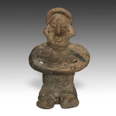
$13.55 Shipping Location: Chicago, United States Normal 0 false false false EN-US X-NONE X-NONE GJPaw Auctions is pleased to offer a Pre-Columbian terracotta Standing Female Figure. From the Colima culture, ... moreWest Mexico. The area known archaeologically as West Mexico has long been recognized as a region of beautiful ceramic sculptures. Manifestations of a reverence for ancestors and a belief in the power of symbolism. These traits are recognized as characteristic of the cultural development of the region during the period from 300 B.C. to 400 A.D. the time of the Colima culture. Colima is best known for its finely finished red burnished effigies, both of humans and animals, especially dogs, and the solid small unburnished figurines, commonly called Colima flats. This beautifully modeled, solid archaic standing female figure is depicted wearing a headband, earrings and a necklace with multiple pendants. It measures 2 inches in width by 0.5 inches in depth by 6 inches in height(5.08 cm by 1.27 cm by 15.2 cm) The figure shows wear consistent with a Pre-Columbian dating, with a hairline cracks on both legs from previous repair work, but generally is in very good condition. It also comes with a specially designed, hand-made iron museum display stand for display. Guaranteed authentic, it would make a superb addition to any collection of Pre-Columbian ceramics. The famous mural artist Diego Rivera began his collection of Mexican pottery with small Colima figures- the collection later grew into a national treasure which was eventually housed in the Rivera Museum in Mexico City. GJPaw Auctions has been in the Art business for over 25 years and is now expanding its operation to eBay. Our goal is to bring the same experience and excitement of collecting that we have been delivering in-person to collectors across the globe at Primitive in Chicago. Every object we sell online has been carefully hand-selected with special attention to detail. Quality, and significance. We ship worldwide. Add GJPaw to Sellers you Follow and please take a moment to look at our other auctio
Buy It Now
$8.95 Shipping Location: Branch, United States The Remingtons' substantial Gothic revival house was situated at 301 Webster Avenue, on a prestigious promontory known as Lathers Hill. A sweeping lawn ... morerolled south toward Long Island Sound, providing views on three sides of the beautiful Westchester County countryside.
Buy It Now
$10.02 Shipping Condition: Unspecified Location: LONDON, United Kingdom 'WESTERN HEMISPHERE'. Title of map:'WESTERN HEMISPHERE'. Antique steel engraved map with original outline hand colouring (coloring), 1844. DATE PRINTED: ... more1844. CONDITION: Good; suitable for framing. The map you will receive is in good condition but there may be minor variations in the condition from that shown in the image.

Buy It Now
$13.55 Shipping Location: Chicago, United States Normal 0 false false false EN-US X-NONE X-NONE GJPaw Auctions is pleased to offer a Pre-Columbian terracotta Standing Figure. From the Colima culture, ... moreWest Mexico. The area known archaeologically as West Mexico has long been recognized as a region of beautiful ceramic sculptures. Manifestations of a reverence for ancestors and a belief in the power of symbolism. These traits are recognized as characteristic of the cultural development of the region during the period from 300 B.C. to 400 A.D. the time of the Colima culture. Colima is best known for its finely finished red burnished effigies, both of humans and animals, especially dogs, and the solid small unburnished figurines, commonly called Colima flats. This unusual and beautifully modeled, solid archaic standing figure is depicted in a casual pose, while in the process of movement. It measures 2 inches in width by 0.5 inches in depth by 6 inches in height(5.08 cm by 1.27 cm by 15.2 cm) The figure shows wear consistent with a Pre-Columbian dating, including rubbing and tiny chips, but generally is in very good condition. It also comes with a specially designed, hand-made museum display stand for display. Guaranteed authentic, it would make a superb addition to any collection of Pre-Columbian ceramics. The famous mural artist Diego Rivera began his collection of Mexican pottery with small Colima figures- the collection later grew into a national treasure which was eventually housed in the Rivera Museum in Mexico City. GJPaw Auctions has been in the Art business for over 25 years and is now expanding its operation to eBay. Our goal is to bring the same experience and excitement of collecting that we have been delivering in-person to collectors across the globe at Primitive in Chicago. Every object we sell online has been carefully hand-selected with special attention to detail. Quality, and significance. We ship worldwide. Add GJPaw to Sellers you Follow and please take a moment to look at our other auction items. A010827-388
Buy It Now
$10.02 Shipping Condition: Unspecified Location: LONDON, United Kingdom DATE PRINTED: This map was originally published by Baldwin & Cradock in 1831; this date is printed on the map. No date is printed on the map itself. Antique ... moresteel engraved map with original outline hand colouring (coloring), 1844.
Buy It Now
$15.00 Shipping Location: Brooklyn, United States Genuine. Antique map"Northern Africa" from Thomas Gamaliel Bradford's Comprehensive Atlas printed in Boston in 1835. Original hand coloring ... moreoutlines areas on this image of northern Africa. Lovely copperplate map shows nice detail of coastlines of the Atlantic. Mediterranean and Red Sea, islands, waterways, mountains and cities. Map is in very good condition, with wide margins and only minor age toning. Minor foxing does not detract from image. Image measures 7 3/4"x 10 1/8" NOT A REPRODUCTION. All of our items are genuine antiques as described.
Buy It Now
$15.00 Shipping Location: Viadana, Italy Notes of a Military Reconnoissance is valuable for a multitude of reasons. folio size cm. 22x15 Print size cm.
Buy It Now
$5.99 Shipping Location: Lummi Island, United States And "who were the earliest inhabitants?". We know that the Vikings preceded Christopher Columbus to the New World by 500 years. But why did they abandon ... moretheir Newfoundland colony?. Mysteries like these are probed, and the answers sought in chapters that approach ancient history topically.

Buy It Now
$10.02 Shipping Condition: Unspecified Location: LONDON, United Kingdom BRITISH NORTH AMERICA Antique steel engraved map with original outline hand colouring(coloring) 1844 Title of map: BRITISH NORTH AMERICA' The image ... morebelow shows an enlarged cross section from the centre of the map to show the level of printed detail: The map shows the border between the United States and British North America(now Canada) as it was before the Oregon Treaty of 1846. And it shows what is now the US state of Alaska as"Russian America" as it was prior to the Alaska purchase of 1867. From the point where the Columbia River meets the 49th parallel, the border between the United States and British North America(now Canada) is shown on the map as following the course of the Course of the Columbia River to the south and west until it reaches the Pacific Ocean. Therefore that part of what is now the US state of Washington to the west of the Columbia River(which includes present-day Seattle-Tacoma) is shown on the map as being part of British North America. The Oregon Treaty of 1846 moved this border to the north, setting the US border with British North America border at the 49th parallel with the exception of Vancouver Island, which was retained in its entirety by the British. The border between Russian America(now Alaska) and British North America(now Canada) is shown to reach the Pacific Ocean further north than its current location; on the map Russian America excludes the island of Revillagigedo Island and adjacent territory, which is now part of Alaska. The border between the United States and Mexico is shown in the lower left hand corner, as it was prior to the Mexican-American war of 1846-1848 with the present US state of California being shown as part of Mexico. DATE PRINTED: This map was originally published by Baldwin& Cradock in 1834; this date is printed on the map. This edition of the map was printed and published by Chapman& Hall in 1844. See comments above. IMAGE SIZE: Approx 33.5 x 40.5cm. 13.25 x 16 inches(Large) ARTIST/CARTOGRAPHER/ENGRAVER: Cartography by Hudson Bay C
$10.00 Shipping Condition: New Location: SALFORD, United Kingdom Huge crowds cheer their majesties at palace - £100,000,000 voted in Commons in five minutes. It was officially stated at the Foreign Office last night ... morethat Great Britain declared war against Germany at 7pm.
Buy It Now
$10.02 Shipping Condition: Unspecified Location: LONDON, United Kingdom 'WESTERN HEMISPHERE'. Title of map:'WESTERN HEMISPHERE'. Antique steel engraved map, 1844. DATE PRINTED: 1844. The image below shows an enlarged cross ... moresection from the centre of the map to show the level of printed detail.
Buy It Now
$10.02 Shipping Condition: Unspecified Location: LONDON, United Kingdom No date is printed on the map itself. Antique steel engraved map, 1848. The image below shows an enlarged cross section from the centre of the map to ... moreshow the level of printed detail VERSO: There is nothing printed on the reverse side, which is plain.
Buy It Now
$8.95 Shipping Location: Branch, United States Darnell progressed from modeling as a child to acting in theater and film. She won critical acclaim for her work in Unfaithfully Yours (1948) and A Letter ... moreto Three Wives (1949). She was the younger sister of Undeen (b. 1918) and the older sister of Monte Maloya (b. 1929) and Calvin Roy, Jr. (b. 1930).
Buy It Now
$14.95 Shipping Location: Rochester, United States Map has ink advertising stamp of Nelson Weed Druggist, Albert Lea, Minn. Bound in salmon wrappers, title printed on cover. Statistics of Dakota and Minnesota ... moreoccupy the final two pages of this booklet.

Buy It Now
$15.00 Shipping Location: Brooklyn, United States 1835 Bradford Map of the Western Hemisphere(North America. South America) WE SELL ONLY ORIGINAL ANTIQUE MAPS- NOT REPRODUCTIONS Title: Western Hemisphere. ... moreDescription: This is a fine 1835 map of the western hemisphere by the important American mapmaker T. G. Bradford. It covers North America. South America, West Indies and most of Polynesia including New Zealand and offers a fascinating snapshot of the world during a period of rapid globalization and discovery. Important cities, rivers, islands and mountains, along with other topographical features are noted throughout. The Antarctic continent, first sighted in 1820, but neglected during the first half of the 19th century, does not appear on the map. The map was published as plate no. 140 in Thomas G. Bradford's 1835 Comprehensive Atlas Geographical, Historical and Commercial. Bradford's atlas, published in 1835 was an important work on many levels. First, it was one of the first American atlases to follow an encyclopedic format, offering readers extensive geographical and statistical tables to supplement the maps themselves. Second, it was published in Boston and influenced the city's rise as a publishing center later in the 19th century(at the time most publishing in the United States was restricted to New York and Philadelphia) Third, this atlas was the first to contain a separate and specific map showing the Republic of Texas. Fourth and finally, Bradford's atlas in some instances broke the Euro-centric mold regarding atlas production. Among other things, Bradford focused his atlas on the Americas and abandoned the classical decoration common in European atlases in favor of a more informational and inherently American approach. Bradford published this atlas in several editions and with various partners. The first edition was published by William D. Ticktor and did not contain the iconic Republic of Texas map(although we have in fact seen Ticktor examples with a Texas map, suggesting, against conventional wisdom, that there may have been two Ti

Buy It Now
$33.81 Shipping Condition: Unspecified Location: LONDON, United Kingdom BRITISH NORTH AMERICA Antique steel engraved map with original outline hand colouring(coloring) 1844 Title of map: BRITISH NORTH AMERICA' The image ... morebelow shows an enlarged cross section from the centre of the map to show the level of printed detail: The map shows the border between the United States and British North America(now Canada) as it was before the Oregon Treaty of 1846. And it shows what is now the US state of Alaska as"Russian America" as it was prior to the Alaska purchase of 1867. From the point where the Columbia River meets the 49th parallel, the border between the United States and British North America(now Canada) is shown on the map as following the course of the Course of the Columbia River to the south and west until it reaches the Pacific Ocean. Therefore that part of what is now the US state of Washington to the west of the Columbia River(which includes present-day Seattle-Tacoma) is shown on the map as being part of British North America. The Oregon Treaty of 1846 moved this border to the north, setting the US border with British North America border at the 49th parallel with the exception of Vancouver Island, which was retained in its entirety by the British. The border between Russian America(now Alaska) and British North America(now Canada) is shown to reach the Pacific Ocean further north than its current location; on the map Russian America excludes the island of Revillagigedo Island and adjacent territory, which is now part of Alaska. The border between the United States and Mexico is shown in the lower left hand corner, as it was prior to the Mexican-American war of 1846-1848 with the present US state of California being shown as part of Mexico. DATE PRINTED: This map was originally published by Baldwin& Cradock in 1834; this date is printed on the map. This edition of the map was printed and published by Chapman& Hall in 1844. See comments above. IMAGE SIZE: Approx 33.5 x 40.5cm. 13.25 x 16 inches(Large) ARTIST/CARTOGRAPHER/ENGRAVER: Cartography by Hudson Bay C
Buy It Now
$15.00 Shipping Location: Viadana, Italy This edition includes reports of Emory and Lt. J. W. Abert on their trip over the Trail with the Army of the West in 1846;. Notes of a Military Reconnoissance ... moreis valuable for a multitude of reasons. California, and the Borderlands.
Buy It Now
$15.00 Shipping Location: Viadana, Italy This edition includes reports of Emory and Lt. J. W. Abert on their trip over the Trail with the Army of the West in 1846;. Notes of a Military Reconnoissance ... moreis valuable for a multitude of reasons. California, and the Borderlands.

Buy It Now
$3.95 Shipping Location: Rochester, United States RARE Old Pocket Map Colton's Township Map of Pennsylvania and the Southern Counties of New York 1876 For offer. A very interesting American imprint! ... moreFresh from a local estate- never offered on the market until now! I could not locate a copy of this book for sale anywhere. Vintage. Old, Original, Antique- NOT a Reproduction- Guaranteed! New York: Colton. 1876. Nicely Hand colored. 44 x 30 inches when fully unfolded. COMPLETE. In very good condition. Acid free archival repair to rips on back and a few fold joints. Front cover nearly detached, hanging on by small piece of paper. Light age toning/ minimal foxing. Please see photos. If you collect 19th century American imprints. Americana illustration, atlas, State of PA- Southern Tier NY, etc. this is a nice one for your bibliophile library or paper/ ephemera collection. Combine shipping on multiple bid wins! Pennsylvania Listeni/ˌpɛnsɨlˈveɪnjə/ Pennsylvania German: Pennsilfaani) Officially the Commonwealth of Pennsylvania, is a U.S. state that is located in the Northeastern and Mid-Atlantic regions of the United States, and the Great Lakes region. The state borders Delaware to the southeast, Maryland to the south, West Virginia to the southwest, Ohio to the west, Lake Erie and Ontario, Canada to the northwest, New York to the north and New Jersey to the east. The Appalachian Mountains run through the middle of the state. Pennsylvania is the 33rd largest. The 6th most populous, and the 9th most densely populated of the 50 United States. The state's five most populous cities are Philadelphia, Pittsburgh, Allentown, Erie, and Reading. The state capital is Harrisburg. Pennsylvania has 51 miles(82 km) of coastline along Lake Erie and 57 miles(92 km)6] of shoreline along the Delaware Estuary. The state is one of the 13 original founding states of the United States. Geography Further information: Geography of Pennsylvania and List of counties in Pennsylvania Counties of Pennsylvania Pennsylvania is 170 miles(274 km) north to south and 283 miles(455 km) ea
Buy It Now
$5.99 Shipping Condition: Like New Location: Lummi Island, United States And "who were the earliest inhabitants?". CONDITION : NEW/LIKE NEW. HUGE hardcover w/dustjacket in mylar. Reader's Digest (1986) 320 pages. Book is new ... moreand unmistakably unread, however dustjacket does show mild shelfwear.
Buy It Now
$10.02 Shipping Condition: Unspecified Location: LONDON, United Kingdom Antique steel engraved map with original hand colouring, 1857. DATE PRINTED: 1857. CONDITION: Good; suitable for framing. TYPE: Antique steel engraved ... moremap with original hand colouring. The image below shows an enlarged cross section from the centre of the map to show the level of printed detail.
Buy It Now
$15.00 Shipping Location: Viadana, Italy This edition includes reports of Emory and Lt. J. W. Abert on their trip over the Trail with the Army of the West in 1846;. Notes of a Military Reconnoissance ... moreis valuable for a multitude of reasons. California, and the Borderlands.
$12.00 Shipping Condition: Used Location: Loomis, United States See pictures for details on condition and design. Although they were two separate tribes, the Alabamas and Coushattas have been closely associated throughout ... moretheir history.
Buy It Now
$136.20 Shipping Location: Stuart, United States Pair of West Mexican matched pottery shaft tomb figures. Both are seated, with open mouths, bulging eyes, cylindrical torso's, ear and nose ornaments, ... morethin pliant limbs. She is wearing corte (skirt), while he is wearing a loin cloth, both have head wear.They are hollow, and believed to have depicted the family members that were buried. They are museum quality,and in very good shape.They measure 1" tall,and 9" across the shoulders. Both weigh just under 20 lbs
Buy It Now
$8.70 Shipping Location: Potomac, United States Volgens de Laatste Ontdekkingen der Jesuiten en andern. te Amsterdam by Isaak Trion.MDCCLXV. in Amsterdam by Isaac Trion. MDCCLXV [1765]. te Amsterdam ... moreby Isaak Trion.MDCCLXV. “Antique map of California.
Buy It Now
$16.95 Shipping Location: Oxford, United States SEE PHOTO-----COMPLETE, ORIGINAL MAP OF FELLS POINT & Harbor East in Baltimore, Maryland dated 1876, This map contains fantastic Baltimore history and ... moredepicts the part of the city bordering the Jones Falls on the West, S. Bond St on the East, Orleans St on the North and the Harbor on the South.
Buy It Now
Location: Bethany, United States Each map will be described from the map closest to the top and going down, w the condition of their wooden pull, again ask for specifics, as these are ... moreestimates, but not grossly over/under estimated. The approach of the civil war.
|