-
Christian Collectibles
-
Christian Sheet Music
-
Vatican Stamps
-
Vatican Coins & Paper Money
-
Antiques
-
Antiquities
-
Architectural & Garden
-
Decorative Arts
-
Ethnographic
-
Furniture
-
Maps, Atlases & Globes
-
United States (Pre-1900)
-
AK, HI
-
AL, FL, GA, MS, NC, SC
-
AR, IA, KS, LA, MO, NE
-
AZ, CA, CO, NM, NV, UT
-
CT, MA, ME, NH, RI, VT
-
DC, DE, MD, NJ, NY, PA
-
ID, OR, WA
-
IL, IN, MI, OH, WI
-
MN, MT, ND, SD, WY
-
OK, TX
-
VA, WV, KY, TN
-
Entire US
-
United States (1900-Now)
-
United States (Date Unknown)
-
Africa
-
Asia
-
Australasia/ Oceania
-
Canada
-
Central America/ Caribbean
-
Europe
-
India
-
Ireland
-
Mexico
-
Middle East
-
North America
-
South America
-
United Kingdom
-
Maps on CD
-
World Maps
-
Globes
-
Mixed Lots
-
Reproductions
-
Price Guides & Publications
-
Other
|
In
Order by: Available to: This site contains affiliate links for which I may be compensated
|
Buy It Now
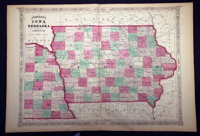
$20.70 Shipping Location: Union, United States This is a hand-colored map, published in 1864. Year: 1864. Country/Area/Region: Iowa and Nebraska. Publisher: A. J. Johnson. Condition: Sealed in plastic ... moreon foam board. Split down middle crease. Light toning, minor chipping.
Buy It Now
$12.45 Shipping Location: Newtown, United States This is a original map, in good condition as shown.
Buy It Now
$6.95 Shipping Location: Dover, United States Issued 1867, New York by A.J. Johnson. Johnson's Iowa and Nebraska. Uncommon mid 19th century lithographed map with original hand color.
Buy It Now
$8.85 Shipping Location: Madbury, United States
Free Shipping Location: Schertz, United States This is an authentic antique map of Iowa and Nebraska from 1863, published by Johnson & Ward. The full-page size is 14x18, with hand-tinted highlights ... morein beautiful color. The map is over 160 years old and is a unique piece of history. The title page is not included, but provided for reference only. This map is a great addition to any collection and comes with free shipping in the USA with calculated shipping worldwide.
Buy It Now
Free Shipping Location: Schertz, United States This is an authentic Johnson Atlas Map of Iowa and Nebraska, dating back to 1862. The map measures 14x18 inches and features hand-tinted highlights. It ... moreis an antique original, over 160 years old, and a great addition to any map collection. Please note that the book cover shown in the picture is for reference purposes only and is not included with the map. For shipping, free shipping is available within the USA, while calculated shipping is offered worldwide. The map is a perfect addition to any antique or map collection and would make a fantastic gift for any history or geography enthusiast.
$6.00 Shipping Location: Corunna, United States 1864 MAP OF IOWA& NEBRASKA Johnson& Ward Hand Colored Lithograph Engraving Click Images to Enlarge An Original Vintage Antique Lithographic Engraved ... morePrint: Not a Reproduction! See Our Ebay Store for other Antique Items! Please visit our parent eBay store(abetteronlinebookstorellc. Feedback over 17,000! Free US Shipping on Purchases of $100 value or more! Details Full Title: 1864 MAP OF IOWA& NEBRASKA Year: 1864 Publisher/Printer: Johnson& Ward Engraving style: Colored Lithograph Condition Grade: Collectible. Good Authentication: Appraisal Valuation Sheet available Appraised Value: $260 Approximate Size(inches) 18" x 26 1/2" Approximate Size(Cm) 57.1 x 67.3 Description This is an authentic antique map approximatley 145 years old! Map Maker/Publisher: Johnson& Ward. 1864. Hand Colored lithographic engraving. Text and chart on reverse. Doublepage map with fold at center. The map is not mounted, matted or framed and is being sold as a single sheet as shown in the first picture. This map is in good condition for its age. Has light soiling, some small tears along edges, and some splitting at lower part of fold that can be repaired. The image is in nice condition. It is basically as seen in the pics. Very clean and would frame up nicely, see pictures for more on condition. The pictures shown are of the actual map being sold. Keywords: Colored Engraved. Iowa, Nebraska, 1800s, Litho, Lithograph, Color Engraving, Atlas Map CUSTOMER SERVICE& PRICING Our pricing directly reflects the time and careful consideration invested in acquiring and researching the finest quality products for you. The discriminating consumer. We recognize that all of our customers have their own specific needs and wants and we strive to meet these needs whether you are an Historical Institution, University, Library, Society, Archivist, Curator, Decorator, Designer, or Collector. We have structured our business to accommodate these requirements. We sell to a select group of customers from beginning collectors to advanc
Buy It Now
Free Shipping Location: Schertz, United States Explore the states of Iowa & Nebraska with this authentic Johnson Atlas Map from 1863. This antique original piece is over 150 years old, perfect for ... morecollectors and history enthusiasts alike. The map measures 14x18 inches and depicts the state during the Civil War period. The map is in excellent condition and comes with free shipping within the US. International shipping is also available with calculated rates. Please note that the title page is not included and is only for reference purposes.
Buy It Now
$6.95 Shipping Location: Northampton, United States From Johnson's 1864 New Illustrated Family Atlas with Physical Geography. Margins are soiled and toned. A few interior spots.
Buy It Now
Free Shipping Location: Schertz, United States This MAP is original and from a Johnson's New Illustrated Family Atlas dated 1864. The map measures 18 X 13" is clean and bright and in very ... moregood condition. S ome maps have a roll to it that will flatten out once it is removed from the atlas. Satisfaction guaranteed. PLEASE CHECK MY EBAY STORE FOR A GOOD SELECTION OF MAPS& POSTCARDS AT REASONABLE PRICES. Please leave a POSITIVE FEEDBACK if satisfied and add PAPER- COLLECTIBLES-4SALE to your favorite sellers list.
Buy It Now
$4.95 Shipping Location: Dover, United States Issued 1870, New York by A.J. Johnson. Johnson's Iowa and Nebraska. Uncommon mid 19th century lithographed map with original hand color.

8h 8m 0s 0 bids
$10.00 Now
$7.25 Shipping Location: Waterloo, United States for sale here is lot of printed angling ephemera as follows south west rod licence dated 1977 devon river board rod licence dated 1953 salmon fisheries ... morerod licence ireland cork district dated 1920 george smith& co receipt for a line dated 1948 map of the halsdon estate fishing rights james wright kelso receipt dated 1948 severn river authority rod licence dated 1970 great ouse river authority rod licence dated 1970 map of the willenhall rights of way beats and access routes etc map of coventry and district angling association canal fishing facilities george smith card trade tackle box alex martin receipt for line dated 1954 similar alex martin receipt for fly rod j a j munro aberlour receipt various tackle dated 1957 welland and nene river authority rod licence dated 1970 victor freed receipt dated 1938 plough angling society rules/regs/permit dated 1970/71 royal leamington spa season ticket dated 1970 coventry and district members year book dated 1970/71 rootes social and athletic club members booklet dated 1968 coventry and district angling association members year book dated 1938/39 a similar coventry and district members book dated 1964/65 severn river authouity rod licence dated 1970. anyway please look at the fotos. I dont have the time to send out individual dispatch emails but items are normally posted the day after being paid for, i will post anywhere insured and recorded, and please view my other many listings of vintage items this week.thanks for looking.and i do eventually get round to leaving feedback once they build up to about 300 i do them all at once.
Buy It Now
Free Shipping Location: Jacksonville, United States Circa 1865 Johnson Ward antique map of Iowa & Nebraska. A beautiful and colorful map from Johnson's New Illustrated Family Atlas, published in 1865. This ... moremap is eye catching with nice original coloring!
Buy It Now
$6.95 Shipping Location: Dover, United States Issued 1879, New York by Alvin J. Johnson & Son. Johnson's Iowa and Nebraska. Uncommon mid 19th century lithographed map, with original hand color. Original ... morecenter fold as issued.
Buy It Now
$6.95 Shipping Location: Dover, United States Issued 1862, New York by Johnson & Ward. Johnson's Iowa & Nebraska. Uncommon mid 19th century lithographed map, with original hand color.
Buy It Now
$6.95 Shipping Location: Dover, United States Issued 1864, New York by Johnson & Ward. Johnson's Iowa and Nebraska. Large civil war era mid 19th century lithographed map with original hand color.
Buy It Now
Free Shipping Location: Schertz, United States This piece was removed from an 1862 JOHNSON ATLAS and is in good condition. The map is not " new " or in " new " condition, it was printed in 1862. The ... moremap is not dated. Study the photos carefully, this is the actual map you will receive.

Buy It Now
$7.00 Shipping Location: North Wales, United States An ORIGINAL antique 1864 map of IOWA and NEBRASKA from JOHNSON'S New Illustrated FAMILY ATLAS. The counties are individually HAND WATERCOLORED and ... morea handful of early railroads are shown in the eastern half of IOWA but none further west than NEVADA. IOWA. Nebraska was still a Territory at the time and only the very eastern part is shown on the map. The western part of the territory was still Indian land at the time. What makes Johnson's maps so desirable is that although many maps from this time period showed railroad routes, his also show major stagecoach and wagon roads. This map shows HUNDREDS of these roads on the map. Among the finest maps produced during the 19th Century. Johnson's maps were used extensively during the Civil War. The map measures 26 by 18 inches and is perfect for matting and framing. This ORIGINAL antique map is guaranteed over 150 years old, published during the CIVIL WAR. I do not sell reproductions, just honest maps at honest prices. Discounted shipping too. I presently have 2 1864 IOWA/NEBRASKA maps up for auction. Note there are minor differences between them. Please see photos. NO international shipping. NO exceptions. All items shipped within 2 business days after payment. If you have not received an item in a reasonable amount of time please email me. It has been delayed by the Post Office. I also accept returns on ANY item for ANY reason, please email me I am very easy to work with. Feedback is not the same thing as an email, please email first. On Oct-19-07 at 13:06:06 PDT. Seller added the following information:
Buy It Now
$4.95 Shipping Location: Dover, United States Issued 1884, Gotha by Justus Perthes for Stieler. Very detailed 19th century engraved map with original hand color. Original fold line as issued.
Buy It Now
$8.60 Shipping Location: Belton, United States Map of Iowa and Nebraska- Johnson and Ward 1864 chart on Reverse Hand Colored engraving Beautiful colors Rare! Ready to be matted and framed! Approx. ... moresize 18" x 26 1/2" inches(57.1 cm x 67.3 cm) Good condition. Full Color Litho Engraving. Double Page map with fold in the center. The map is not mounted. Matted, or framed and is being sold as a single sheet as shown in the pictures. Map is clean and still have a strong presence. Some small marks and soiling around margins. May have other light marks, excess paper on edge, and some other small tears. Has some splitting at lower part of fold. See pics! Would frame up great! Inventory# MA-00150-PR42 Will be listing many more Rare maps! Be sure to check them all out!

Buy It Now
Free Shipping Location: Schertz, United States An ORIGINAL antique 1868 map of IOWA NEBRASKA from JOHNSON'S New Illustrated FAMILY ATLAS. The counties are individually hand water colored and a ... morenumber of early railroads are shown with their names printed next to them. Only the eastern 1/3 of NEBRASKA is shown as the western half was still largely INDIAN land at the time. What makes Johnson's maps so desirable is that although many maps from this time period showed railroad routes. His also show major stagecoach and wagon roads. This map shows hundreds of these roads. Among the finest maps produced during the 19th Century. Johnson's maps were used extensively during the Civil War. The map measures 26 by 18 inches and is perfect for matting and framing. This ORIGINAL antique map is guaranteed over 145 years old, published just after the CIVIL WAR. I do not sell reproductions, just honest maps at honest prices. Discounted shipping too. Note there is a 1 1/2 inch separation of the bottom end of the page fold line but no loss of paper. NO international shipping. NO exceptions. All items shipped within 2 business days after payment. If you have not received an item in a reasonable amount of time please email me. It has been delayed by the Post Office. I also accept returns on ANY item for ANY reason, please email me I am very easy to work with. Feedback is not the same thing as an email, please email first. On Oct-19-07 at 13:06:06 PDT. Seller added the following information:
Buy It Now
Free Shipping Location: Schertz, United States This piece was removed from an 1861 JOHNSON ATLAS and is in good condition. The map is not " new " or in " new " condition, it was printed in 1861. The ... moremap is not dated. Study the photos carefully, this is the actual map you will receive.
Buy It Now
Free Shipping Location: Sayville, United States
Buy It Now
Free Shipping Location: Schertz, United States Johnson's Iowa and Nebraska from U.S. Atlas 1863 by Johnson and Ward genuine antique map some discoloring typical of age 18" x 14"
Buy It Now
$6.00 Shipping Location: Jacksonville, United States 1862 Johnson Ward antique map of Iowa & Nebraska. A beautiful and vibrantly colored map from the 1862 Johnson New Illustrated Family Atlas. Overall, good ... morecondition.
Buy It Now
$6.80 Shipping Location: Rochester, United States Vintage Rand McNally atlas double sided map page of Iowa and Nebraska circa 1898. Measures 11 1/4 X 14 1/4 inches in size (29 X 36cm). Map is an authentic ... moreoriginal in acceptable condition as shown in photos.
Buy It Now
Free Shipping Location: Anaheim, United States Double-sided - Nebraska on one side and Iowa on the other. Old Paper Map. Map is folded. CONDITION:biopredation (silverfish), corners bent.
Buy It Now
$5.49 Shipping Location: Georgetown, United States North Dakota South Dakota Nebraska Kansas Minnesota Iowa Missouri Map.
Buy It Now
$6.90 Shipping Location: Frankfort, United States 1902 TWO SIDE 21.5" x 13.3" MAP. THIS MAP IS OVER 120 YRS OLD AND IN NOT IN PERFECT CONDITION.SOME TEARS AND AGING PAPER.CHECK PHOTOS CAREFULY BEFORE ... morePURCHASE.
Buy It Now
$6.95 Shipping Location: Dover, United States Issued 1870, New York by A.J. Johnson. Johnson's Iowa and Nebraska. Uncommon mid 19th century lithographed map with original hand color.
Buy It Now
$6.95 Shipping Location: Dover, United States Johnson's Iowa and Nebraska. Fine large format mid 19th century lithographed map with original hand color. Original center fold as issued.
Buy It Now
$6.95 Shipping Location: Dover, United States Issued 1880 Gotha by Justus Perthes for Stieler. Very detailed 19th century engraved map with original outline hand color. Original center fold as issued.
Buy It Now
$4.15 Shipping Location: Saco, United States Up for Sale is a Beautiful & Authentic Colored County & Territorial Map of TEXAS!This Double Page Map was Harvested from an 1865 A. J. Johnson's Family ... moreAtlas. Title Page is shown in the last photo which is not included.
Buy It Now
$4.95 Shipping Location: Dover, United States Issued 1862, New York by Johnson & Ward. Johnson's Iowa and Nebraska. Fine lithographed map, with original hand color.
Buy It Now
Free Shipping Location: Schertz, United States Explore the historic beauty of Iowa and Nebraska with this antique original 1863 map from Johnson & Ward's Atlas. Measuring 14x18 inches, this steel plate ... moremap features the original colors of the region and highlights the US States of Iowa and Nebraska. The map is a perfect addition to any collection of North America maps, atlases, and globes. Free S&H is available for customers in the USA, while calculated S&H is available for worldwide shipping. Don't miss the opportunity to own a piece of history with this stunning map from Johnson & Ward's Atlas.
Buy It Now
$3.75 Shipping Location: United States Rare, superb, antique 1862 handcolored map, titled Johnson's Iowa and Nebraska, and at lower right hand side By Johnson and Ward. Fascianting, detailed ... moreand attractive period handcolored map of Iowa and Nebraska, with gorgeous delicate period handcoloring.
Buy It Now
$3.75 Shipping Location: United States Rare, superb, antique 1863 handcolored map, titled Johnson's Iowa and Nebraska, and at lower right hand side By Johnson and Ward. Fascianting, detailed ... moreand attractive period handcolored map of Iowa and Nebraska, with gorgeous delicate period handcoloring.
Buy It Now
$4.00 Shipping Location: United States Fine, rare, antique 1862 handcolored map, titled Johnson's Iowa and Nebraska. Superb and detailed period map, with fine handcoloring, nice outside ornate ... moreborder and fascianting period details and areas.
Buy It Now
$5.00 Shipping Location: Jefferson City, United States YEAR: 1863. TITLE : Johnson's New Illustrated Family Atlas. SUBJECT: States of Iowa & Nebraska. Atlas cover and title page are not included and pictured ... morefor date and authenticity purpose only. PUBLISHER: Johnson & Ward.
Buy It Now
$6.95 Shipping Location: Dover, United States Issued 1880 Gotha by Justus Perthes for Stieler. Very detailed 19th century engraved map with original outline hand color. Original center fold as issued.
Buy It Now
$5.25 Shipping Location: Dayton, United States This is a Map titled "Index Map Of Missouri River In The Vicinity Of Omaha, Nebraska & Council Bluffs, Iowa," 1911. 27-62nd Congress, 2nd Session, December ... more4, 1911-August 26, 1912: Examinations Of Rivers and Harbors IV.".

Buy It Now
Free Shipping Location: Schertz, United States An ORIGINAL antique 1866 map of IOWA NEBRASKA from JOHNSON'S New Illustrated FAMILY ATLAS. The counties are individually hand water colored and a ... morenumber of early railroads are shown with their names printed next to them. Only the eastern 1/3 of NEBRASKA is shown as the western half was still largely INDIAN land at the time. What makes Johnson's maps so desirable is that although many maps from this time period showed railroad routes. His also show major stagecoach and wagon roads. This map shows hundreds of these roads. Among the finest maps produced during the 19th Century. Johnson's maps were used extensively during the Civil War. The map measures 26 by 18 inches and is perfect for matting and framing. This ORIGINAL antique map is guaranteed over 145 years old, published just after the CIVIL WAR. I do not sell reproductions, just honest maps at honest prices. Discounted shipping too. NO international shipping. NO exceptions. All items shipped within 2 business days after payment. If you have not received an item in a reasonable amount of time please email me. It has been delayed by the Post Office. I also accept returns on ANY item for ANY reason, please email me I am very easy to work with. Feedback is not the same thing as an email, please email first. On Oct-19-07 at 13:06:06 PDT. Seller added the following information:
Buy It Now
Free Shipping Location: Schertz, United States This piece was removed from an 1863 JOHNSON ATLAS and is in good condition. The map is not " new " or in " new " condition, it was printed in 1863. The ... moremap is not dated. Study the photos carefully, this is the actual map you will receive.
Buy It Now
$4.13 Shipping Location: Mason, United States Quadrangle Fremont, Nebraska; Iowa; Western United States 1:250,000. US Geological Survey Topography Map,1955 Revised 1971. In excellent condition. See ... morepictures.
Buy It Now
$5.00 Shipping Location: Canada DATE OF ISSUE: 1936.
Buy It Now
$5.00 Shipping Location: Jacksonville, United States 1863 Johnson Ward antique map of Nebraska & Iowa. A beautiful and colorful map from Johnson's New Illustrated Family Atlas, published in 1863. This map ... moreis eye catching with nice original coloring! Overall, very good.
Buy It Now
Free Shipping Location: San Antonio, United States This Map was removed from a 1862 Atlas and is in good acceptable condition. This map is not new or in new condition, it was printed in 1862. Including ... moreHundreds of RareCivil War. pencil marks & brittle paper from over 160+ years of aging.
Buy It Now
$4.15 Shipping Location: Saco, United States Up for Sale is a Beautiful Colored County Map of Iowa and the Eastern Part of Nebraska.This Single Sheet Double Page Map was Extracted by Myself from ... morean 1867 A. J. Johnson's Family Atlas. The Outer Edge or the Map will have Browning, Smudges and/or Stains.
Buy It Now
$6.75 Shipping Location: Wataga, United States This antique atlas from Alvin Jewett Johnson showcases the beautiful states of Iowa and Nebraska in 1867. It contains detailed maps that illustrate the ... moreregions' geography, landmarks, and topography. The atlas comes in its original form, and the print quality is well-preserved. You can see the intricate cartography of the United States of America, with Iowa and Nebraska states highlighted. This is a perfect addition to any map or antique collector's collection.
Buy It Now
Free Shipping Location: San Antonio, United States This Map was removed from a 1861 Atlas and is in good acceptable condition. This map is not " new " or in " new " condition, it was printed in 1861. Including ... moreHundreds of RareCivil War. pencil marks & brittle paper from over 160+ years of aging.
Buy It Now
Free Shipping Location: Orlando, United States
Buy It Now
$17.45 Shipping Location: Monroeville, United States Date - 1872. Source - H. H. Lloyd Atlas of the United States. or send resale number.
Buy It Now
$4.95 Shipping Location: Dover, United States Issued 1864, New York, A. J. Johnson. Johnson's Iowa & Nebraska. Original fold line as issued. Paper and image remains overall clean & sound. Condition ... moreis carefully considered in arriving at our price.
Buy It Now
Free Shipping Location: Monroeville, United States Map is in very good condition as shown Posted with
Buy It Now
$4.95 Shipping Location: Reading, United States SHEET 17 1/2" X 13"; CARTOGRAPHY BY JOHNSON & WARD, RIVERS & TRIBUTARIES; TOWNS & COUNTIES, SETTLEMENTS, ETC.
Buy It Now
$8.50 Shipping Location: Croatia City, seat (1855) of Douglas county, eastern Nebraska, U.S. It is situated on the west bank of the Missouri River opposite Council Bluffs, Iowa. Inc. ... moretown, 1854; city, 1857. Area city, 115 square miles (298 square km).
Buy It Now
$5.00 Shipping Location: Canada DATE OF ISSUE: 1932. ORIGIN OF THE MAP: "Stielers Handatlas", published in Gotha, Germany by Justus Perthes.
Buy It Now
$6.50 Shipping Location: Corunna, United States Title page in photos is not included in sale, It is shown for authentication purposes only.
Buy It Now
$7.00 Shipping Location: Rockville, United States Published by Johnson and Ward, New York - 1863. Up for sale is a great, colored antique MAP - JOHNSON'S MAP OF IOWA AND NEBRASKA - 1863. I would be happy ... moreto include a copy if requested.
Buy It Now
$6.95 Shipping Location: Dover, United States Issued 1894 Gotha by Justus Perthes for Stieler. Very detailed 19th century engraved map with original & outline hand color. Original center fold as issued.
|
|
|
In
|
Large Antique Color 1864 Johnson's Map Iowa & Nebraska Civil War Era
WELCOME TO BEANSANTIQUES We are proud to announce that we are ebay.ca's winner of the 2010 Family Business Of The Year If photos do not download for you. Please let us know and we will email them to you directly. We are offering to you a lovely antique map. This great antique map is a Johnson's of New York map titled; Iowa& Nebraska It is about 18" x 26.5" A lovely color and would look just great in a frame. Dated 1864 In good shape with normal age wear and toning. A crease in the center, some minor stains. Has a small piece missing at the bottom center boarder. Published by A J Johnson on New York. A very rare old piece that will look wonderful in a frame We recently bought a collection of maps that all came out an 1870 Johnson's map book/atlas. These maps were mounted with paper hinges so they could be removed ... morefrom the book. There is some of the hinge paper still attached on the back at the center fold. Has printed pages on the back. This printing does not show through the map. See our other listing to see all of these wonderful pieces. No additional shipping charges for multiple purchases. You only pay for shipping one piece no mater how many you buy and have shipped at the same time. This piece will be rolled lightly and placed in a box for shipping A great addition to your collection! Any questions please email. Check our other listings to combine shipping. We NEVER CHARGE a handling fee just actual mailing costs through Canada Post. We mail next day after payment. Why drive all over when you can get i t here! and have i t delivered to you. Please consider the photos to be part of the description. SHIPPING: We invite you to click on this link to see our shipping info and our GUARANTEE to you SHIPPING& GUARANTEE This link will also show you who we are and what we do Cost is actual mailing. WE DO NOT CHARGE A HANDLING FEE. We do professional packing on site and this is FREE to you. We as the Seller. TAKE RESPONSIBILITY FOR ANYTHING DAMAGED in transit. This is absolutely not your j
|
|
|
1913 ATLAS NEBRASKA DOUGLAS SARPY WASHINGTON IOWA MILLS POTTAWATTAMIE COUNTY
1913 ATLAS NEBRASKA DOUGLAS SARPY WASHINGTON IOWA MILLS POTTAWATTAMIE COUNTY For your consideration is a 1913 Atlas of Douglas. Sarpy, Washington Counties, Nebraska and Mills and Pottawattamie Counties Iowa. It was compiled by the Anderson Publishing Co. Chicago, Illinois for The Bee Publishing Co of Omaha, Nebraska. The Atlas has pages of Township plat maps for each county that include the names of the property owners, location, and acres. Atlas also includes an outline map of Douglas, Sarpy, and Washington Counties in Nebraska and Mills and Pottawatamie Counties in Iowa. Included are maps of Omaha and South Omaha. Nebraska and Council Bluffs, IA. Book is in overall fair condition. The front hard cover has separated from the staple bound maps and the back hard cover is starting to separate. The first 23 pages have ink or oil stain along ... morethe sides. The stains are not on the maps. There is a crease on page 51 Jamestown map which also affect page 52 Valley map. The Loveland map on page 67 has a tear and missing information which also affects the map on the reverse side page 68 Mills County map. The Council Bluffs and Greater Omaha map is starting to separate from the binding. Back inside cover has some handwriting in pencil"AA 2189 $22.50" For it's age. Most of the Township maps have held up fairly well(see photos) Pages have age related color, and some stains(see photos) Book measures approximately 11 3/4" x 14" x 1/4" Due to improper storage over the last 99 years, it will need an airing out. Ships with Delivery Confirmation. Happy to combine shipping on multiple purchases. PAYMENT IS DUE IN 5 DAYS
|
|
|
Iowa East Nebraska Des Moines Polk County 1863 antique engraved map
Iowa East Nebraska Des Moines Polk County 1863 antique engraved map Iowa and Nebraska Issued 1863. New York by Johnson and Ward Fine original antique engraved map. Printed on quality paper which retains its inherent structural flexibility and soundness. Nice Civil War era map. Original hand color. In near VG or better condition. Short tear at top right into the border which is cleanly closed on back with archival tape and is easy to miss or overlook, some minor age wear but the image remains clean, attractive and very presentable[note: we grade very conservatively and always seek to disclose any noteworthy flaws] The printed area remains visually pleasing. A nice impression of an interesting antique map. Any minor defects along the sheet edges and in the margins may be seen in the photos. Sheet measures c. 17 3/4" W x 13 1/2" H. ... moreEngraved area measures c. 17 1/8" W x 12 1/4" H. 36758] note: All old sheets of printed paper possibly have short edge splits. Each sheet has existed for a very long time and has probably been handled repeatedly in the course of it's existence. It has a history unique to it as an object. Most of the time any edge splits are short. Minor, insignificant and have been closed- either long ago or more recently with small pieces of archival tape. Most often these splits are trivial and easy to overlook visually. Basically, they would not significantly affect the piece adversely. The item is offered as seen. Please look carefully and make your decision knowing this antique image is nice. But it is not in perfect"like new" condition. However, with whatever flaws it possesses, it remains entirely worthy of ownership and inclusion in any related collection. We feel it will prove very pleasing to its new owner. We stand behind everything we sell. Everything we offer is guaranteed to be an authentic original antique item as described. We do not sell modern reproductions. Please visit our eBay Store. We happily accept PayPal!
|
|
|
1864 hand colored map of Iowa and Nebraska, Johnson's, 25 x 17
Hand colored map of Iowa and Nebraska from A.J. Johnson. Believed 1864. 26 3/4" by 18" Tape repairs on back. Edge chips as seen. Puncture in the center with little loss of paper. Folded in half. Some general notes for all the maps I am listing now. Measurements are approximate from edge to edge of the paper. Images are generally smaller. I believe colored maps to be hand-colored. Not machine colored. I got these maps loose and do not have personal knowledge as to actual original sources. In some cases dates and original sources are clearly stated as part of the map, in most cases dates and sources I give are based on information that was written in pencil on the maps when I got them. I can not give any more information as I am not a map expert. All maps are definitely originals, not modern reprints or reproductions. Maps that are ... morealready folded will be shipped folded; maps that are not folded will be shipped flat. Buyer pays actual postage cost plus a $1.50 handling fee. I don’t mind shipping by media mail or shipping winnings from different auctions together to save you postage. I do not take credit cards directly but you can pay by credit card through Paypal. I do not wait for checks to clear. Please pay within one week. If you know you have a vacation or business trip coming up or will just be overwhelmed with other things that will interfere with paying me on time please get in touch with me ahead of time- before you bid- I will be glad to talk about letting you take longer as long as I am asked first. If you have questions feel free to ask. I try to make sales easy and pleasant for my winners. Check out other books. Magazines, music and random amazing stuff I'm selling by clicking here: Check out my!
|
|
|
1869 ORIGINAL "Emigrants Crossing the Plains," Nebraska, Kansas, Iowa, Missouri
Original uncolored engraving as issued. Blank on verso. Dated in the plate. Engraved by H.B. Hall. Drawn by Darley. Published by D. Appleton. Entered into US Congress. 1869. Image area is 9.25" w. X 7.5" h. with wide margins. Beautifully executed will frame nicely. Overall good condition with mild ageing. Low starting bid with no reserve. Shipping cost is for insured priority mail.
|
|
|
1861 Map of Iowa and part of Nebraska Johnson and Browning. original
Johnson's New Map of Iowa and part of Nebraska From the Johnson and Browning Atlas of 1861. Advertised by the maker as a Steel Plate engraving. Alvin Jewitt Johnson was a prolific mapmaker of the 19th Century who recognized a need for quality American maps during it's period of rapid growth. Around 1859. Johnson purchased the engraved steel plates created by G.W. Colton and the copyrights for his maps. This map is from the Johnson and Browning Atlas of 1861, In his attempt to create an attractive. High-quality product to compete with the mapmakers of Europe, Johnson added ornate borders to the plates. He also continued to employ a staff of professional colorists to add the vivid hand applied washes to the lithographed maps. This map was published in New York The Title page from the atlas indicates that Johnson and Browning are successors ... moreto J.H Colton. The size of this original map is about 14 x 18 inch. The photo shown is an actual photo of the map I am offering for sale.
|
|
|
Iowa Nebraska together state maps 1864 antique Johnson large hand color map
Iowa and Nebraska Issued 1864. New York by A.J. Johnson Fine original antique engraved& lithographed map. With lovely original hand color. Printed on quality paper which retains its inherent structural flexibility and soundness. In near VG or better condition. Mostly clean and attractive, minor light surface age wear[note: we grade very conservatively and always seek to disclose any noteworthy flaws] The printed area remains visually pleasing. A nice impression of an interesting antique map. Any minor defects along the sheet edges and in the margins may be seen in the photos. Sheet measures c. 26 1/2" W x 17 3/4" H. Engraved area measures c. 22 7/8" W x 16 5/8" H. Original fold line as issued. 42316] Guaranteed Authentic! We do not sell modern reproductions. Condition All of our items are original antique pieces and ... moreit is important to keep in mind that many of them have been around for 100 years or more. Individual pieces may have seen many owners and been handled many times over the course of their existence and as a result each piece has developed a history of it's own. Short edge splits(often repaired with archival tape) Foxing, discoloration, etc. are all things to expect on items of this type. They rarely distract from the piece and often add to the overall character of the item. Keep in mind when you receive your item that you are not handling a modern copy, you are holding a piece of history, an item that has been around for a very long time and will, with proper care, be around for a long time to come. We try to note any significant flaws in the description, but less noticeable or common characteristics may not be mentioned. As we are a US based company all of our measurements are in Inches. If you need the size in Centimeters please multiply the supplied measurement by 2.53. Payment and Shipping We happily accept PayPal! Payment is appreciated within 5 days of invoicing. Once payment has been received we do our best to make sure all orders are shipped within two business days
|
|
|
RARE 1864 Hand Colored Engraving JOHNSON'S MAP OF IOWA AND NEBRASKA
Auction Wizard 2000 Listing Template- AW2KLOT#6901 Please note that Customs delays for international shipping have been SIGNIFICANT lately- days or even weeks longer than they should be! Please take this into consideration Our goal is 5 star service! If you feel we have not lived up to a 5 star rating. Please contact us as we only want 100% satisfied customers and NO misunderstandings! Description below pictures* RARE 1864 Hand Colored Engraving JOHNSON'S MAP OF IOWA AND NEBRASKA* $124.95 An Original Vintage Antique Map: Not a Reproduction! See Our Ebay Store for other Antique Maps! Free US Shipping on Purchases of $100 value or more of Maps and Prints Description: This is an authentic antique engraved print over 145 years old. JOHNSON'S MAP OF IOWA AND NEBRASKA" Published by Johnson& Ward. New York, 1864. Doubledpage engraving. ... moreWonderful steel engraved print with original hand coloring. Wonderful detail. A BEAUTIFUL original map which would look fantastic matted and framed! It is being sold as a single sheet. Not mounted, matted or framed as shown in the first picture. Overall a nice print which would mat and frame up very well. Size: Nice size. 18" x 26 1/2" overall(57.1 x 67.3 cm) as seen in the pictures. Condition: This print is in good condition for its age with light soiling. Blank on reverse. Minor small tears along edges and some splitting at lower part of fold, can be repaired. The image is in very nice condition and will frame up nicely. The pictures shown are of the actual print being sold. Shipping: Please use the calculator under the"Shipping and payments" tab above to determine shipping for your location. All packages are sent with Delivery confirmation where possible. We always combine shipping. So on multiple items please wait until we send you an invoice with the correct shipping applied. Maps and Prints will be shipped either flat or rolled depending on the items being shipped. We use only sturdy shipping materials to make sure the package arrives at its dest
|
|
|
1861 Johnson Map - Iowa & Nebraska - Des Moines Omaha Muscantine City Davenport
Lake Erie Maps& Prints! An Original Antique Map: Not a Reproduction! See Our Ebay Store for More! Free Shipping on Purchases of 5 or More Maps and Prints Description: It is an authentic engraved antique Civil War era map approximately 150 years old with original handcoloring as issued. It is from the 1861 Edition of Johnson's Family Atlas. A copy of the title page is included for authenticity. It is not matted. Mounted nor framed being sold as a single sheet as shown in the main pic. Overall a very nice map in great condition that would frame up beautifully with an antique appearance as desired. Size: The map image measures approximately 12 by 16 inches on a 14 by 18" 36x45cm) page with a margin all around for framing. Condition: The map is in Good condition for its age with overall tonal aging. Printed on a heavy page with original ... morehand coloring. There is some darkening and staining mainly around the edges, see the pics for more on condition. Overall, it is very clean with strong color that would frame up nicely. The pics are of the actual map. It is much better than in the pics. Payment Details: We accept most major credit cards through Paypal and Ebay. Please ask if you have any questions about payment. International and New Bidders are welcomed and encouraged. Payment is expected within 7 days. After which Nonpaying Bidders will be reported to Ebay to recoup our listing fees. Save on Shipping: We only charge one shipping fee based on the largest map or print with multiple items shipped along with it for no extra costs. Purchase 5 or more maps or prints and receive Free First Class shipping in USA or First Class International elsewhere in the world. Although registration may be required on shipments of high value. International Customs and VAT Fees: It is the responsibility of the buyer to pay all Customs Taxes. VAT or other fees that may be due upon arrival. These fees vary greatly from country to country and ebay policy is that the buyer is responsible for their country's taxes and fees. Ple
|
|
|
1868 IOWA NEBRASKA Map JOHNSON ATLAS CIVIL WAR Hand Watercolor
An ORIGINAL antique 1868 map of IOWA NEBRASKA from JOHNSON'S New Illustrated FAMILY ATLAS. The counties are individually hand water colored and a number of early railroads are shown with their names printed next to them. Only the eastern 1/3 of NEBRASKA is shown as the western half was still largely INDIAN land at the time. What makes Johnson's maps so desirable is that although many maps from this time period showed railroad routes. His also show major stagecoach and wagon roads. This map shows hundreds of these roads. Among the finest maps produced during the 19th Century. Johnson's maps were used extensively during the Civil War. The map measures 26 by 18 inches and is perfect for matting and framing. This ORIGINAL antique map is guaranteed over 145 years old, published just after the CIVIL WAR. I do not sell reproductions, ... morejust honest maps at honest prices. Discounted shipping too. Note there is a 1 1/2 inch separation of the bottom end of the page fold line but no loss of paper. NO international shipping. NO exceptions. All items shipped within 2 business days after payment. If you have not received an item in a reasonable amount of time please email me. It has been delayed by the Post Office. I also accept returns on ANY item for ANY reason, please email me I am very easy to work with. Feedback is not the same thing as an email, please email first. On Oct-19-07 at 13:06:06 PDT. Seller added the following information:
|
|
|
1864 MAP OF IOWA & NEBRASKA Johnson & Ward Hand Colored Lithograph Engraving
1864 MAP OF IOWA& NEBRASKA Johnson& Ward Hand Colored Lithograph Engraving Click Images to Enlarge An Original Vintage Antique Lithographic Engraved Print: Not a Reproduction! See Our Ebay Store for other Antique Items! Please visit our parent eBay store(abetteronlinebookstorellc. Feedback over 17,000! Free US Shipping on Purchases of $100 value or more! Details Full Title: 1864 MAP OF IOWA& NEBRASKA Year: 1864 Publisher/Printer: Johnson& Ward Engraving style: Colored Lithograph Condition Grade: Collectible. Good Authentication: Appraisal Valuation Sheet available Appraised Value: $260 Approximate Size(inches) 18" x 26 1/2" Approximate Size(Cm) 57.1 x 67.3 Description This is an authentic antique map approximatley 145 years old! Map Maker/Publisher: Johnson& Ward. 1864. Hand Colored lithographic engraving. Text ... moreand chart on reverse. Doublepage map with fold at center. The map is not mounted, matted or framed and is being sold as a single sheet as shown in the first picture. This map is in good condition for its age. Has light soiling, some small tears along edges, and some splitting at lower part of fold that can be repaired. The image is in nice condition. It is basically as seen in the pics. Very clean and would frame up nicely, see pictures for more on condition. The pictures shown are of the actual map being sold. Keywords: Colored Engraved. Iowa, Nebraska, 1800s, Litho, Lithograph, Color Engraving, Atlas Map CUSTOMER SERVICE& PRICING Our pricing directly reflects the time and careful consideration invested in acquiring and researching the finest quality products for you. The discriminating consumer. We recognize that all of our customers have their own specific needs and wants and we strive to meet these needs whether you are an Historical Institution, University, Library, Society, Archivist, Curator, Decorator, Designer, or Collector. We have structured our business to accommodate these requirements. We sell to a select group of customers from beginning collectors to advanc
|
|
|
1871 Crofutt Map of Omaha, Nebraska and Council Bluffs, Iowa
1871 Crofutt Map of Omaha. Nebraska and Council Bluffs, Iowa WE SELL ONLY ORIGINAL ANTIQUE MAPS- NOT REPRODUCTIONS Title: Crofutt's New Map of Omaha and Council Bluffs. Showing the New Railroad Bridge over the Missouri River, Connecting the Two Cotoes. Description: This is a scarce 1871 George A. Crofutt map of Omaha. Nebraska and Council Bluffs, Iowa, showing the railroad bridge over the Missouri River, connecting the two cities. Centered on the Missouri River, the map covers the cities of Omaha and Council Bluffs in great detail, showing streets, lakes, railway lines and topography. The bridge over the Missouri River includes an illustration of a train entering Omaha. The Union Pacific Railroad Bridge was the first bridge across the Missouri river. The bridge first opened in 1872, a year after this map was issued, but was damaged due ... moreto severe winds in 1877. It would go on to be rebuild in 1888 and in 1916. The upper right quadrant of the map includes portraits of Hon. Oliver Ames, First President of the Union Pacific Railroad and Hon. Thomas A. Scott, Second President of the Union Pacific Railroad. This map was engraved expressly for, and issued as part of Crofutt's Trans-Continental Tourist's Guide. Size: Printed area measures 12.5 inches high by 15.5 inches wide. Condition: Very good. Minor toning along original fold lines. Professionally flattened and backed with archival tissue. Shipping: Due to recent increases in United States Postal Service rates we have been forced to increase our shipping rates. Shipping rates are not negotiable. Items are shipped within three business days of receiving payment. We are happy to consolidate shipping where possible. The following shipping options are available: 1. USPS Domestic Express Mail(35 USD) USA Only. 2. USPS Priority Mail(15 USD) USA Only. 3. USPS International Express(35 to 55 USD) Recommended service for all international parcels. You will be invoiced at the lowest Express Mail rate possible. 4. USPS Priority Mail(35 USD) Available to only certain
|
|
|
Iowa & Nebraska 1864 Map By Johnson & Ward Hand Colored Cities Railroads
Iowa& Nebraska 1864 Map By Johnson& Ward Hand Colored Cities Railroads IOWA& NEBRASKA Original 1864 Iowa& Nebraska map by Johnson and Ward. Hand colored. Good condition, overall size 18' x 13 1/2' Purchase with confidence. We have been in the antique print, map, and document business since 1976 and guarantee our items as advertised. See additional photos below! The black circles that show in some of the listings are magnets that we use to hold image. To See More Photos/Scenes Powered by Click Here. Double your traffic. Get Vendio Gallery- Now FREE!
|
|
|
1866 IOWA NEBRASKA Map JOHNSON ATLAS CIVIL WAR Hand Watercolor
An ORIGINAL antique 1866 map of IOWA NEBRASKA from JOHNSON'S New Illustrated FAMILY ATLAS. The counties are individually hand water colored and a number of early railroads are shown with their names printed next to them. Only the eastern 1/3 of NEBRASKA is shown as the western half was still largely INDIAN land at the time. What makes Johnson's maps so desirable is that although many maps from this time period showed railroad routes. His also show major stagecoach and wagon roads. This map shows hundreds of these roads. Among the finest maps produced during the 19th Century. Johnson's maps were used extensively during the Civil War. The map measures 26 by 18 inches and is perfect for matting and framing. This ORIGINAL antique map is guaranteed over 145 years old, published just after the CIVIL WAR. I do not sell reproductions, ... morejust honest maps at honest prices. Discounted shipping too. NO international shipping. NO exceptions. All items shipped within 2 business days after payment. If you have not received an item in a reasonable amount of time please email me. It has been delayed by the Post Office. I also accept returns on ANY item for ANY reason, please email me I am very easy to work with. Feedback is not the same thing as an email, please email first. On Oct-19-07 at 13:06:06 PDT. Seller added the following information:
|
|
|
1862 Johnson Map of Iowa & Nebraska * Original Antique! #10
1862 Johnson This beautiful map is from Johnson's Family Atlas with original hand coloring. Johnson was one of the premier American map publishers of the 19th century. Known for their excellent detail and beautiful coloring. Published by Johnson and Ward: New York. 1862. This is an original antique. NOT a reproduction and guaranteed to be over 150 years old. Condition: Very Good Size: Sheet size 18" x 14" or 46cm x 35.5cm. Please click on my"ME" page to learn more about us. Looking for additional quality items? Check out our other auctions and store items for more that we have listed on eBay! Powered by The free listing tool. List your items fast and easy and manage your active items.
|
|
|
Authentic Hand Colored 1862 Johnson and Ward Map of Iowa And Nebraska
Map is in very good condition as shown Posted with
|
|
|
Rare Hand Colored Johnson's Lithographed Folio Map 1865: Iowa and Nebraska
C I R Q L A R Original antique prints. Books, maps and atlases Image Name Johnson's Iowa and Nebraska. Author/Artist Johnson and Ward. Date of Publication Published New York by A.J. Johnson. 1865 Miscellany Difficult to acquire original hand colored large lithographed map of Iowa and Nebraska. Map Dimensions Folio: 18" X 26 1/2" Condition In overall very good to excellent condition. Description We are proud to be able to offer a difficult to acquire a difficult to acquire map from Johnson's New Illustrated Family Atlas published in 1865. It is indeed a rare map in exceptional. Largely apology-free condition. Thank you for looking and please be sure and look at our other auctions for other fine original natural history plates as well as original maps. All guaranteed original. Thank you for looking. We do not use the eBay ... morecheck-out system for invoicing so it is not necessary to email us at auction end. You will receive an email from Paypal letting you know the particular payment options available to you. We will also send you an email summarizing your winning bids along with one combined postal charge. We will email you this summary within 24 hours after the auction's end. Cirqlar is a SquareTrade seller in good standing and we will do everything we can make this a positive experience for you. We don't hold checks for clearance(we have yet to receive a bad check after over 25.000 transactions! Again, we will be happy to combine purchases to save on your shipping costs. News flash! We are now using USPS for our North American shipments. Shipments are easy to track. And, well, frankly we have only lost one singular package out of the tens of thousands of packages we have sent. Good job USPS! If you are one of our International friends. Please contact us with your particulars(name of country, insurance requirements if any) so that we might get as accurate a quote as possible to get your purchase to you in a timely fashion. Please note that we now have(finally. Mercifully) a legitimate"ab
|
|
|
Iowa Nebraska Two Sided Map Color Tinted 1899 by Matthews Northrup Co.
Offered is a vintage tinted two side map Iowa and Nebraska 1899 by Mattews Northrup Co Good condition with age toning and a tiny tear a the bottom middle margin. Measures 13 1/2" X 21 1/2" This will ship flat and not rolled up. THANKS FOR LOOKING! We will GLADLY combine shipping for you if you purchase more than one item! Payment Instructions: We accept PayPal only; payment is expected within three days. If payment is not received by then an unpaid item case will be filed with eBay in order to recover our listing fees. Refund Policy: We are agreeable and want you to be happy with your purchase. If you feel we have erred in the description. Please let us know right away and we will make arrangements for a refund. We will refund your high bid plus what you paid for shipping upon receipt of the item. The item must be returned in the ... morecondition it was shipped. Powered by The free listing tool. List your items fast and easy and manage your active items.
|
|
|
Map from Johnson's New Illustrated Family Atlas 1867/70 - Iowa Nebraska US
This auction is for the Iowa and Nebraska 2-state map from the Johnson's New Illustrated Family Atlas of the World. By Prof. A.Guyot. The entire state of Iowa is shown but Nebraska is a partial map. I am also listing the other Nebraska map. This map is in very nice condition given its age. It is in its original unrestored condition. The colors(all hand colored) are still very vibrant and all of the map is still very readable. There is one pretty sizeable stain on the eastern portion of Nebraska. The seam is very much intact but like the map has some pretty obvious stains. I have tried to highlight all these main issues in the pictures. These maps were given to me from an estate to sell. I say this for transparency. As I will not be of much help in grading the shape of the maps. However, I will answer any question as quickly as I can. ... moreI do have the entire book(covers are in very poor condition) but it has already been split up. I will be posting a few sections at a time but they are in a pretty random order as I don't really know much about which may be more desirable. If the postings are up at the same time, I will be happy to combine shipping. If you are looking for a particular map, you can ask if I have it and I can see about posting it sooner. I have included the title page and copyright info as a reference. These are not included with the map. I will ship these media mail in tubes. Other shipping methods will be done at customer request and will be paid for above the basic shipping cost. Please let me know any shipping requests before paying so I can create and invoice. Single Page Map: 13.25 inches x 18 inches. Two Page Map: 26.5 inches x 18 inches.
|
|
|
1864 Johnson Iowa Nebraska Civil War Hand Colored Map 18x26 Vintage US States
VINTAGE 1864 JOHNSON MAP OF IOWA AND NEBRASKA Approximately 18" by 26" This vintage map is a great souvenir. It is in very good overall condition with wear at the edges and fold lines. I have taken a picture of the item so you can make your own judgment of its condition and bid accordingly. The item will be folded and protectively shipped. Please feel free to ask me any questions you desire. Winning bidder will be contacted promptly after end of auction and payment is expected within 4 days. I accept Paypal as well as whatever other payment methods are still allowed by eBay policies at the time of purchase. Shipping and handling is $4.95 within the US. This includes delivery confirmation tracking. This item will not be shipped overseas.
|
|
|
1862 Johnson Map of IOWA, NEBRASKA * Original Antique! 9B
1862 Johnson Map of IOWA. NEBRASKA* Original Antique! 9B This beautiful map is from the famous Johnson Family Atlas with original hand coloring. Johnson was one of the two premium American map publishers of the era from 1860 to 1885. They are renown for their Civil War era maps. This is an original antique. NOT a reproduction and guaranteed to be over 150 years old. Size: Sheet size of print is 18" x 14" or 46cm x 36cm. Please click on my"ME" page to learn more about us. Looking for additional quality items? Check out our other auctions for more that we have listed on eBay! RcmdId ViewItemDescV4,RlogId p4%60bo7%60jtb9%3Fuk.rp*4a24%60%3C%3E-14551896413-0x10d-
|
|
|
Large Antique Map Iowa & Nebraska 1864 Johnson s Family Atlas 150 Years Old
Large Antique Map Iowa& Nebraska 1864 Johnson s Family Atlas 150 Years Old You will be bidding on an Large Antique Nebraska& Iowa Map from an 1864 Johnson s Family Atlas. 150 Year Old Civil War Edition. This hand colored Steel Plate engraving Map was published by Johnson& Ward. Measures 26 1/2" x 18 3/16" and is in good condition with light foxing, creasing and minimal staining as shown. Overall nice condition for a map that is 150 years old and is suitable for immediate framing. I can send more pictures upon request as well and I thank you for looking. I gladly combine shipping! Please view the other Antique Maps and Collectible items I have for sale now on Ebay at the link below. Check out my other items! Shipping/Handling is paid by buyer. I accept Paypal. International bidders are welcome but please request a shipping ... morequote from me before bidding. Questions are always welcome and Please bid with confidence! My Policies: Another auction from Antiques Advisors. Powered by
|
|
|
Map, USA,Iowa,Nebraska, hand colored, 1864, by Johnson,Large
Click Here. Double your traffic. Get Vendio Gallery- Now FREE! Map. USA,Iowa,Nebraska, hand colored, 1864, by Johnson,Large, Click to View Image Album Sheet size; 26 x 18 inch( 65 x 45 cm) Text on reverse Click here to view our other auctions Click here to view our other auctions New Page 3 Click here to view our other auctions Click here to view our other auctions Click here to view our other auctions. New items are listed everyday. All starting at 99c. All items can be combined to save on postage costs. Click here to view our new store Albion-Prints to view our other auctions by category. Click here to view our sister site ntrcollectibles. IMPORTANT- PLEASE READ Payment of invoices must be received within 5 days of receipt. We send invoices within 24 hours of auctions ending. We always consolidate postage for multiple purchases. If you ... moreare intending to bid on lots which have not yet ended and want postage costs combining. This is acceptable. However the first check out note MUST be paid within 5 days of receipt. We can hold the lots until you are ready for dispatch, but each checkout note must be paid within 5 days of receipt. We are unable to hold lots that are not paid for within 5 days. If you are unable to pay within 5 days PLEASE DO NOT BID. We have had to introduce these new terms as we are having an increasing number of slow payers and customers who just do not pay. Thank you. Payment& Returns All items are returnable for a full refund or credit. Payment Methods Accepted Paypal in any major currency Direct Credit Card/Debit Card Other methods with prior arrangement Shipping*WE POST TO ALL WORLDWIDE LOCATIONS* Please note: Because of the new eBay shipping requirements we now have to display exact shipping for each item. To find out how much shipping costs please check below. Postage within the UK appears under the International Shipping section(Even though we are based in the UK) Feel free to pay immediately if you purchase one item. If more than one item is purchased please wait for an invoic
|
|
|
JOHNSON’S Map IOWA & NEBRASKA by Johnson & Ward, from 1862 Atlas IA & NE
JOHNSON’S Map IOWA& NEBRASKA by Johnson& Ward. From 1862 Atlas IA& NE Not dated. But we got it from the atlas, which was dated 1862. Size: 14 ¼” by 18” Condition: Very good. Slight age staining and 2 minor(1/8” tears along the top edge. A 1" tear along the right edge, and a half inch tear on the left edge. THIS IS A NO RESERVE AUCTION! All our items are guaranteed to be as described. Buyer pays shipping. Handling and insurance. Ohio residents, please add sales tax at your county’s rate.
|
|
|
1892 Perron map OMAHA, NEBRASKA & COUNCIL BLUFFS, IOWA (#467)
ReclusIn16_467 1892 Perron map OMAHA. NEBRASKA& COUNCIL BLUFFS, IOWA(467) Nice map titled Council Bluffs et Omaha. From wood engraving with fine detail and clear impression. Nice hand coloring, text in French on the back. Overall size approx. 24.5 x 18.5 cm, image size approx. 14 x 10 cm. From La Nouvelle Géographie universelle. La terre et les hommes. 19 vol. 1875-94) great work of Elisee Reclus. Cartographer is Charles Perron. Please me if you have any questions. I prefer payment by PayPal. But I'll also accept any other payment method and currency(except direct payment by credit card) that is convenient for buyer. I combine shipping of multiple items. IMPORTANT NOTE ABOUT SHIPPING: Price quoted with auction is for surface mail to European countries. Please don't pay before you receive invoice from me. If shipping address ... moreis within Europe I recommend surface mail. You don't gain much time with airmail, it is just more expensive. g6.RcmdId ViewItemDescV4,RlogId p4%60bo7%60jtb9%3Fuk%601d72f%2B%3Eg6%3E-14804698080-0x104-
|
|
|
1864 Original, enrgraved, full color map: "Johnson's Iowa and Nebraska"--
Pacific Shore Maps San Diego. CA 92124 Title: Johnson’s Iowa and Nebraska” Cartographer: Johnson and Browning Time and Place: 1864; NYC Publisher: Johnson and Ward Reference: New Illustrated Family Atlas” Dimensions& Type: 12 x 16. Steel plate engraving with hand color applied by counties. ORI GINAL, not a Reproduction Condition: VG. A bit of dirt in the outermost margins Description: The legend in the lower r i ght reads"Johnson& Ward" in the example offered here for sale. This is a late versuion to have tghe"bank note" decorative border Really a map of Iowa with the first four tiers of Nebraska Territory’s rece ntly formed-at least on paper—counties. East and South Iowa shows extensive settlement with a network of rail lines while the NW is a series of counties without towns. But only Buncome County in the extreme ... moreNW will disappear. To be replaced by Lyon. In Nebraska Territory. M any of the third tier of counties will disappear or evolve into something else. L’eau qui Court“ will become part of Knox while Monroe will be absorbed into Platte. Jefferson will slide left and replace Jones while itself being replaced by Thayer. A transitional map of the Trans-Mississippi Wes t. Plate 54 from the atlas; Johnson Map Project reference V 6.0* Also visit“mapseller01” or Google“Pacific Shore Maps” for more cartography Normal 0 false false false EN-US X-NONE X-NONE.RcmdId ViewItemDescV4,RlogId p4%60bo7%60jtb9%3Feog4d71f%2B%3F4f%3E-148a18f0e21-0x10c-
|
|
|
1864 IOWA NEBRASKA Map JOHNSON ATLAS CIVIL WAR Hand Watercolor
An ORIGINAL antique 1864 map of IOWA NEBRASKA from JOHNSON'S New Illustrated FAMILY ATLAS. The counties are individually hand water colored and a number of early railroads are shown with their names printed next to them. Only the eastern 1/3 of NEBRASKA is shown as the western half was still largely INDIAN land at the time. The western edge of the map also shows the Proposed Route of the future Pacific[Transcontinental] Railroad. What makes Johnson's maps so desirable is that although many maps from this time period showed railroad routes. His also show major stagecoach and wagon roads. This map shows hundreds of these roads. Among the finest maps produced during the 19th Century. Johnson's maps were used extensively during the Civil War. The map measures 26 by 18 inches and is perfect for matting and framing. This ORIGINAL antique ... moremap is guaranteed over 145 years old, published just after the CIVIL WAR. I do not sell reproductions, just honest maps at honest prices. Discounted shipping too. NO international shipping. NO exceptions. All items shipped within 2 business days after payment. If you have not received an item in a reasonable amount of time please email me. It has been delayed by the Post Office. I also accept returns on ANY item for ANY reason, please email me I am very easy to work with. Feedback is not the same thing as an email, please email first. On Oct-19-07 at 13:06:06 PDT. Seller added the following information:
|
|
|
2 maps, 1880: IOWA & MISSOURI; COLORADO, KANSAS, NEBRASKA & WYOMING; Bartholomew
2 Bartholomew maps: KANSAS. NEBRASKA, COLORADO. DAKOTA, WYOMING And PART OF MONTANA, with MANITOBA* IOWA& MISSOURI This is a pair of detailed antique maps on a single sheet which measures 12.5 x 17 inches overall. On the left half of the page is shown a large swath of the Plains and Rocky Mountain regions—Colorado. Kansas, Missouri, Dakota, Wyoming and the majority of Montana, at a scale of approximately 100 miles to the inch. On the right half are Iowa and Missouri, at a scale of approx. 50 miles to the inch. Both maps are attractively colored. And show railroad lines in their regions. The ranges of Indian tribes in the west are shown, and the county lines are shown for all these states and territories. For instance, at the time, Colorado had 21 counties, vs. the 63 counties into which the state is now divided. The map is in Fine condition. ... moreAnd is blank on the back. The credit lines in small print below the map say: Engraved& Printed in Colours— by J. Bartholomew T. Ellwood Zell. Davis& Co. Philadelphia. The map is undated on the plate. But came from an uncommon atlas published in Philadelphia in 1880, which was Volume 5 of Zell’s Popular Encyclopedia. The mapmaker. John Bartholomew, was a Fellow of the Royal Geographical Society. The map will be accompanied by 7 text pages. Presenting lists of each state's counties and populations, plus a key to the many features shown on the maps: hundreds of towns and cities, and rivers, mountains, etc. The map will be shipped folded once. As originally published in Zell’s Atlas. SHIPPING/ HANDLING TERMS: Add a flat $ 3.95 for delivery by First Class Mail anywhere in the U.S. Pennsylvania residents. Add 6% tax. International shipping is $ 8.95 to Canada; or $13.95 to all other foreign countries. I normally mail items within 24 hours of receiving payment. All items are returnable for a full refund if the buyer is unsatisfied for any reason. gsrx_vers_526(GS 6.6.6(526) A;06d2.RcmdId ViewIte
|
|
 |