-
Christian Collectibles
-
Christian Sheet Music
-
Vatican Stamps
-
Vatican Coins & Paper Money
-
Antiques
-
Antiquities
-
Architectural & Garden
-
Decorative Arts
-
Ethnographic
-
Furniture
-
Maps, Atlases & Globes
-
United States (Pre-1900)
-
AK, HI
-
AL, FL, GA, MS, NC, SC
-
AR, IA, KS, LA, MO, NE
-
AZ, CA, CO, NM, NV, UT
-
CT, MA, ME, NH, RI, VT
-
DC, DE, MD, NJ, NY, PA
-
ID, OR, WA
-
IL, IN, MI, OH, WI
-
MN, MT, ND, SD, WY
-
OK, TX
-
VA, WV, KY, TN
-
Entire US
-
United States (1900-Now)
-
United States (Date Unknown)
-
Africa
-
Asia
-
Australasia/ Oceania
-
Canada
-
Central America/ Caribbean
-
Europe
-
India
-
Ireland
-
Mexico
-
Middle East
-
North America
-
South America
-
United Kingdom
-
Maps on CD
-
World Maps
-
Globes
-
Mixed Lots
-
Reproductions
-
Price Guides & Publications
-
Other
|
In
Order by: Available to: This site contains affiliate links for which I may be compensated
|
Buy It Now
$6.95 Shipping Location: Dover, United States Issued c. 1862, Paris by Andriveau-Goujon. Very uncommon scarce mid 19th century folio sheet lithographed map with original hand color. Decorative piano ... morekey border. From a rare atlas of this era. 2" split at centerfold base which touches just into the border and is now closed on reverse with archival tape (all but invisible once map is laid open flat).
Buy It Now
$11.85 Shipping Location: Dover, United States 1777 Bowen folio hand color map. Issued 1777, London for Middleton. Map by Thomas Bowen. Very nice 18th century engraved map with attractive hand color.
Buy It Now
$11.85 Shipping Location: Dover, United States Issued 1797-1804, United States by Bradley. Map is perfect candidate for basic cleaning restoration but worthy of display as it survives.
Buy It Now
$11.85 Shipping Location: Dover, United States Issued c. 1930's, Chicago & Denver by the Clason Map Co. F. Mann & Co., Winthrop Mass.
Buy It Now
Free Shipping Location: Sayville, United States Plate 62 from the 1897 Century Atlas.
Buy It Now
Free Shipping Location: Sayville, United States Plate 91 from the 1897/1902 Century Atlas.
Buy It Now
$5.99 Shipping Location: Bodega Bay, United States Color lithograph by The Century Company shows details, such as cities, towns, counties, lakes, rivers, railroads, and elevation. Measures 12” x 16”. Vintage ... moreoriginal very detailed not a reprintSee photos for more details.

Buy It Now
Free Shipping Location: Sayville, United States 1897 MAP OF AUSTRIA-HUNGARY WESTERN PART Century Co 90 Color Litho Engraving Click Images to Enlarge Details Full Title: MAP OF AUSTRIA-HUNGARY. WESTERN ... morePART WITH INSETS OF VIENNA(WEIN) AND VICINITY Year: 1897 Publisher/Printer: The Century Co. Engraving style: Colored Lithograph Condition Grade: Collectible. Very Good+/Fine Authentication: Appraisal Valuation Sheet available Appraised Value: $70 Approximate Size(inches) 16 1/2" x 11 3/4" Approximate Size(Cm) 41.9 x 29.8 Description This is an authentic antique map approximatley 116 years old! Map Maker/Publisher: The Century Co. 1897. Colored lithographic engraving. Blank on reverse except for titling. Doublepage map with fold at center. The map is not mounted, matted or framed and is being sold as a single sheet as shown in the first picture. This map is in Very good to Fine condition. It is clean and still has strong presence. Very light wear. It is basically as seen in the pics. Very clean and would frame up nicely, see pictures for more on condition. The pictures shown are of the actual map being sold. Keywords: Colored Engraved. Austria-Hungary, Western, Vienna, 1800s, Litho, Lithograph, Color Engraving, Atlas Map CUSTOMER SERVICE& PRICING Our pricing directly reflects the time and careful consideration invested in acquiring and researching the finest quality products for you. The discriminating consumer. We recognize that all of our customers have their own specific needs and wants and we strive to meet these needs whether you are an Historical Institution, University, Library, Society, Archivist, Curator, Decorator, Designer, or Collector. We have structured our business to accommodate these requirements. We sell to a select group of customers from beginning collectors to advanced, seasoned collectors and everyone in between. Our many years of positive feedback from the thousands of loyal customers most often reflects the Quality of our items, Fine packaging, and Great Customer Service. Below are some of the finer points of what sets us apar
Buy It Now
Free Shipping Location: Sayville, United States Plate 63 from the 1897/1902 Century Atlas.
Buy It Now
$14.60 Shipping Location: Syracuse, United States Printing by New York The Century Co. Rough, traveled and stained but looks complete. The item you see is the actual item you are buying, unless there ... moreare multiples for sale. Further, old plastic tends to get brittle & especially withTOYS, can break easy under 'typical' use.
Buy It Now
Free Shipping Location: San Diego, United States Date & Place: 1926. Number 108 of 1500. 41 pages plus 79 map illustrations many tipped in and in color. 41 page "Catalogue of the Atlases, Chart-books ... moreetc in the Mac Pherson Collection". More often seen with red cover, but this is brown leather.
Buy It Now
Free Shipping Location: Sayville, United States Has an inset for Providence & Vicinity. Plate 10 from the 1897/1902 Century Atlas.
Buy It Now
Free Shipping Location: Sayville, United States Plate 90 from the 1897/1902 Century Atlas.
Buy It Now
$11.00 Shipping Location: Rockville, United States Up for sale is a beautiful, colored map of Hamburg published c1846. Very nice view of the city from the middle of the 19th century. Overall nice condition. ... moreOne edge is rough cut from its removal from binding.
Buy It Now
$6.75 Shipping Location: Fallbrook, United States Vintage Color Map of Italy Matted Map Copyright, 1897 & 1902, Century Co. The map measures 15" X 11 and With the matte the map measures 20" x 16" . The ... morenote on the back from the printer says "original map plate dating from 1903. Please see pictures for details. H10
Buy It Now
$6.95 Shipping Location: Dover, United States Issued c. 1855-60, Edinburg by A, Fullarton & Co. Drawn & engraved by Swanston. Mid 19th century lithographed map with original hand color. Countries ... morein the Northern Tropical Regions of Africa.
Buy It Now
$5.99 Shipping Location: Bodega Bay, United States Color lithograph by The Century Company shows details, such as cities, towns, counties, lakes, rivers, railroads, and elevation. Measures 12” x 16”. Vintage ... moreoriginal very detailed not a reprintSee photos for more details.
Buy It Now
$6.75 Shipping Location: Athens, United States Connecticut & Rhode Island - Original 1902 Map by The Century Co. RI Antique. Map from The New Century Atlas 1902. Map is about 16" x 11.5". Map has a ... morecrease down the middle from the fold in the signature. Please see pictures for condition and let me know if you have any questions.

Buy It Now
$3.50 Shipping Location: Bar Harbor, United States Auction Wizard 2000 Listing Template- AW2KLOT#7605 Please note that Customs delays for international shipping have been SIGNIFICANT lately- days or even ... moreweeks longer than they should be! Please take this into consideration Our goal is 5 star service! If you feel we have not lived up to a 5 star rating. Please contact us as we only want 100% satisfied customers and NO misunderstandings! Description below pictures* 1897 MAP OF NEBRASKA* Colored Lithograph Engraved Map* Century Co. $34.95 An Original Vintage Antique Map: Not a Reproduction! See Our Ebay Store for other Antique Maps! Free US Shipping on Purchases of $100 value or more of Maps and Prints MAP OF NEBRASKA with inset of Omaha Description: This is an authentic antique map approximatley 116 years old! Map Maker/Publisher: The Century Co. 1897.Colored lithographic engraving. Blank on reverse except for titling. Doublepage map with fold at center. The map is not mounted. Matted or framed and is being sold as a single sheet as shown in the first picture. Would Frame up Nicely! Size: Map measures approximately 16 1/2" x 11 3/4" 41.9 x 29.8 cm) including margins as seen in the pictures. Condition: This map is in Very good to Fine condition. It is clean and still has strong presence. Singlepage map as seen in the pictures. Very light wear. It is basically as seen in the pics. Very clean and would frame up nicely. See pictures for more on condition. The pictures shown are of the actual print being sold. Shipping: Please use the calculator under the"Shipping and payments" tab above to determine shipping for your location. All packages are sent with Delivery confirmation where possible. We always combine shipping. So on multiple items please wait until we send you an invoice with the correct shipping applied. Maps and Prints will be shipped either flat or rolled depending on the items being shipped. We use only sturdy shipping materials to make sure the package arrives at its destination in undamaged condition. Insurance is on US! Please ask i
Buy It Now
Free Shipping Location: Sayville, United States Plate 42 from the 1897/1911 Century Atlas.
Buy It Now
Free Shipping Location: Sayville, United States Has an inset for the Pittsburg area. Plate 16 from the 1897/1902 Century Atlas.
Buy It Now
Free Shipping Location: Sayville, United States Plate 17 from the 1897/1902 Century Atlas.
$25.00 Shipping Location: Perugia, Italy Beautiful Thomson map focusing on the southeastern parts of Europe.
$19.99 Shipping Location: Albuquerque, United States Antique original map of Omaha, Nebraska. Omaha and Environs, corrected to date and issued for J.M. Wolfe & Co’s City Directory, Omaha, Nebraska, 1887. ... moreSmith, Co. Surveyor.”. Small hole along one of the map crease lines.
Buy It Now
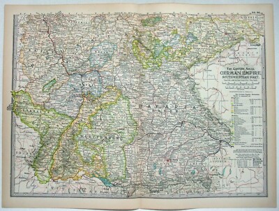
Free Shipping Location: Sayville, United States F R E E S H I P P I N G I N U S A This item is original and not a reproduction print. GERMAN EMPIRE. EASTERN PART. PLATE NO. 86 Map was Engraved for The ... moreCentury Co. by The Matthews-Northrup Co. Buffalo, NY Copyright. 1897 Description: This map was removed from The Century Atlas of the World Prepared Under the Superintendence of Benjamin E. Smith. A.M. c. 1897-1899) This map covers the German Empire. The Southwestern Part. Published in original"contemporary" color(not handtinted) You'll note the name of the map and a legend for the map. The plate number is listed on the outside edge of the map. As well as on the backside of the paper. There is also a brief description of what this map covers(see photo) There is a center fold line. The page was attached to a book by a linen strip(guard) which was sewn into the binding. This small linen strip is still attached to the backside of the map. Measures: 12-7/8 x 17" outside edge of paper) Untrimmed and suitable for framing. Condition: Unless otherwise noted. This map is in Very Good condition. The map is clean and bright. There is browning or oxidation of the paper on the outside 1/2" edge of the page all the way around the map. Paper is healthy. Still supple and crisp to the touch. You can see the engraving impressions on the backside of the map. No restoration work has been done. No structural flaws noted. I.e. no tears, stains, puncture holes, crinkles, bumped edges, worm holes, no spots of foxing, no mildew or mold, no offensive odors, and no trimming of edges. Who Are We? We've been selling on EBay since 2002. We're proud to have 100% feedback. We're known for great packaging to ensure that your item(s) arrive safe and as described. Please note that the items we typically sell are vintage and antique and are sold"as is" We make every effort to photograph and describe our merchandise with much detail. Questions: We welcome and encourage your questions regarding this item prior to bidding and purchase. Please note: Unless a
Buy It Now
$5.99 Shipping Location: Bodega Bay, United States Color lithograph by The Century Company shows details, such as cities, towns, counties, lakes, rivers, railroads, and elevation. Measures 12” x 16”. Vintage ... moreoriginal very detailed not a reprintSee photos for more details.

Buy It Now
$3.50 Shipping Location: Bar Harbor, United States Auction Wizard 2000 Listing Template- AW2KLOT#7568 Please note that Customs delays for international shipping have been SIGNIFICANT lately- days or even ... moreweeks longer than they should be! Please take this into consideration Our goal is 5 star service! If you feel we have not lived up to a 5 star rating. Please contact us as we only want 100% satisfied customers and NO misunderstandings! Description below pictures* 1897 MAP OF CENTRAL AMERICA* Colored Lithograph Engraved Map* Century Co. $34.95 An Original Vintage Antique Map: Not a Reproduction! See Our Ebay Store for other Antique Maps! Free US Shipping on Purchases of $100 value or more of Maps and Prints MAP OF CENTRAL AMERICA with inset of the country around Lake Nicaragua. Showing the route of the Nicaragua Canal now under construction Description: This is an authentic antique map approximatley 116 years old! Map Maker/Publisher: The Century Co. 1897.Colored lithographic engraving. Blank on reverse except for titling. Doublepage map with fold at center. The map is not mounted. Matted or framed and is being sold as a single sheet as shown in the first picture. Would Frame up Nicely! Size: Map measures approximately 16 1/2" x 11 3/4" 41.9 x 29.8 cm) including margins as seen in the pictures. Condition: This map is in Very good to Fine condition. It is clean and still has strong presence. Singlepage map as seen in the pictures. Very light wear. It is basically as seen in the pics. Very clean and would frame up nicely. See pictures for more on condition. The pictures shown are of the actual print being sold. Shipping: Please use the calculator under the"Shipping and payments" tab above to determine shipping for your location. All packages are sent with Delivery confirmation where possible. We always combine shipping. So on multiple items please wait until we send you an invoice with the correct shipping applied. Maps and Prints will be shipped either flat or rolled depending on the items being shipped. We use only sturdy shipping materials t
Buy It Now
$5.99 Shipping Location: Bodega Bay, United States Color lithograph by The Century Company shows details, such as cities, towns, counties, lakes, rivers, railroads, and elevation. Measures 12” x 16”. Vintage ... moreoriginal very detailed not a reprintSee photos for more details.
Buy It Now
$11.85 Shipping Location: Dover, United States Issued 1873, New York by J. David Williams. Map of Texas. Uncommon late 19th century lithographed state map with lovely original hand color.
Buy It Now
$9.90 Shipping Location: Dover, United States Issued c. 1740-50, Nuremberg by Homann. Fine mid 18th century folio sheet engraved map, with full original hand color.

Buy It Now
$11.00 Shipping Location: Rockville, United States Fine Adornment of European History. Creative& Imaginative Gift 1846 Goodrich Map Spain& Portugal Hand-Colored. Intricate Engraved Detail. Fine ... moreSamuel Goodrich Map. Engraved by G.W. Boynton. Original 1846. 168-yrs-old. Map is in Fair/Good Condition: No folds or writings. Mild foxing. Nominal fraying. Some bleed from opposing page. Not a Reproduction. Original Map Engraved by G.W. Boynton for the 1846 Edition of The Book of History Combined with Geography. Comprising the History and Geography of The Western Hemisphere; Samuel Goodrich, Published by Jenks, Hickling, Swan, Boston, 1846; a copy of the Title Page of which is Included. Handsome Adornment of History. Steel-Plate Engraved. Hand-Colored. I sell only Original Maps: No copies or reproductions. Press Here View My Collection. Impressive on Any Home or Office Wall Dimensions: 5 1/4" x 7" Fine Adornment of Spanish& Portuguese History. The Auction is for the Map Itself. A Frame is Not Included. The Framed Map Pictured is a Personal 1846 Goodrich Map Featured to Show the Beauty when Framed. Free Shipping Special(within the USA) All credit cards. Debit cards, electronic checks accepted through Paypal. Maps are mailed within 1-3 days of payment and normally arrive within 3-5 days. Please email with any questions. Imaginative& Creative Gift. Greetings from Historical Savannah. Georgia; founded 1733. Some. To beautify their halls, chambers, studies, or libraries.loveth, getteth, and useth maps, charts, and geographical globes. John Dee, Advisor to Elizabeth I. Press The Link Below To View My Collection. Powered by The free listing tool. List your items fast and easy and manage your active items.
Buy It Now
$6.95 Shipping Location: Dover, United States Issued 1858, Philadelphia by S. Augustus Mitchell. Mid 19th century antique engraved map with original hand color. Map of the State of Texas.
Free Shipping Location: Schertz, United States This antique original map of Missouri from 1886 features all the townships and railroads of the state. With vibrant colors, the map measures 17x27 inches ... moreand was published by J.T. Barker and H.R. Page & Co. The map is a rare find, printed over a century ago and still in great condition. The cartographer and publisher put careful attention to detail, making it a valuable piece for collectors of North American maps and antiques. This map is a unique representation of Missouri's history and would make a great addition to any collection.
Buy It Now
Free Shipping Location: Sayville, United States Plate 80 from the 1897/1902 Century Atlas.
Buy It Now
Free Shipping Location: Sayville, United States Has an inset for Newport RI. Plate 10 from the 1897/1902 Century Atlas.
Buy It Now
$5.99 Shipping Location: Bodega Bay, United States Color lithograph by The Century Company shows details, such as cities, towns, counties, lakes, rivers, railroads, and elevation. Measures 12” x 16”. Vintage ... moreoriginal very detailed not a reprintSee photos for more details.
Buy It Now
Free Shipping Location: Sayville, United States Plate 17 from the 1897 Century Atlas.
Buy It Now
Free Shipping Location: Sayville, United States THE CENTURY COMPANY ATLAS MAP PLATE#18 OHIO SOUTHERN PART 1897 VINTAGE The Century Atlas Company of New York City map plate#18 Ohio Southern Part circa ... more1897. Measures 11 3/4 X 16 1/4 inches in size(30 X 41cm) Map is an authentic original in good condition as shown in photos. Map printed on high quality paper suitable for framing.
Buy It Now
$20.13 Shipping Location: Medlow Bath, Australia This is an unusual map published by John Tallis & Co. London & New York. The map was drawn and engraved by J. Rapkin and the vignettes drawn by H. Warren ... moreand engraved by J. B. Allen.
Buy It Now
$24.23 Shipping Location: Dover, United States Arbuckle Coffee- Map Cards. Issued c. 1880-1890's, NY by Arbuckle Brothers Coffee Co.

Buy It Now
$3.50 Shipping Location: Bar Harbor, United States Auction Wizard 2000 Listing Template- AW2KLOT#7575 Please note that Customs delays for international shipping have been SIGNIFICANT lately- days or even ... moreweeks longer than they should be! Please take this into consideration Our goal is 5 star service! If you feel we have not lived up to a 5 star rating. Please contact us as we only want 100% satisfied customers and NO misunderstandings! Description below pictures* 1897 MAP OF THE DOMINION OF CANADA AND NEWFOUNDLAND* Century Co. $40.00 An Original Vintage Antique Map: Not a Reproduction! See Our Ebay Store for other Antique Maps! Free US Shipping on Purchases of $100 value or more of Maps and Prints MAP OF THE DOMINION OF CANADA AND NEWFOUNDLAND MA-00100-PR38 Description: This is an authentic antique map approximatley 116 years old! Map Maker/Publisher: The Century Co. 1897.Colored lithographic engraving. Blank on reverse except for titling. Doublepage map with fold at center. The map is not mounted. Matted or framed and is being sold as a single sheet as shown in the first picture. Would Frame up Nicely! Size: Map measures approximately 16 1/2" x 11 3/4" 41.9 x 29.8 cm) including margins as seen in the pictures. Condition: This map is in Very good to Fine condition. It is clean and still has strong presence. Singlepage map as seen in the pictures. Very light wear. It is basically as seen in the pics. Very clean and would frame up nicely. See pictures for more on condition. The pictures shown are of the actual print being sold. Shipping: Please use the calculator under the"Shipping and payments" tab above to determine shipping for your location. All packages are sent with Delivery confirmation where possible. We always combine shipping. So on multiple items please wait until we send you an invoice with the correct shipping applied. Maps and Prints will be shipped either flat or rolled depending on the items being shipped. We use only sturdy shipping materials to make sure the package arrives at its destination in undamaged condition. Insurance
Buy It Now
$5.99 Shipping Location: Bodega Bay, United States Color lithograph by The Century Company shows details, such as cities, towns, counties, lakes, rivers, railroads, and elevation. Measures 12” x 16”. Vintage ... moreoriginal very detailed not a reprintSee photos for conditionSee photos for more details.

Buy It Now
$3.50 Shipping Location: Bar Harbor, United States Auction Wizard 2000 Listing Template- AW2KLOT#7626 Please note that Customs delays for international shipping have been SIGNIFICANT lately- days or even ... moreweeks longer than they should be! Please take this into consideration Our goal is 5 star service! If you feel we have not lived up to a 5 star rating. Please contact us as we only want 100% satisfied customers and NO misunderstandings! Description below pictures* 1897 MAP OF MASSACHUSETTS* Colored Lithograph Engraved Map* Century Co* $34.95 An Original Vintage Antique Map: Not a Reproduction! See Our Ebay Store for other Antique Maps! Free US Shipping on Purchases of $100 value or more of Maps and Prints MAP OF MASSACHUSETTS with inset of Boston Description: This is an authentic antique map approximatley 116 years old! Map Maker/Publisher: The Century Co. 1897.Colored lithographic engraving. Blank on reverse except for titling. Doublepage map with fold at center. The map is not mounted. Matted or framed and is being sold as a single sheet as shown in the first picture. Would Frame up Nicely! Size: Map measures approximately 16 1/2" x 11 3/4" 41.9 x 29.8 cm) including margins as seen in the pictures. Condition: This map is in Very good to Fine condition. It is clean and still has strong presence. Singlepage map as seen in the pictures. Very light wear. It is basically as seen in the pics. Very clean and would frame up nicely. See pictures for more on condition. The pictures shown are of the actual print being sold. Shipping: Please use the calculator under the"Shipping and payments" tab above to determine shipping for your location. All packages are sent with Delivery confirmation where possible. We always combine shipping. So on multiple items please wait until we send you an invoice with the correct shipping applied. Maps and Prints will be shipped either flat or rolled depending on the items being shipped. We use only sturdy shipping materials to make sure the package arrives at its destination in undamaged condition. Insurance is on US! Pl

Buy It Now
$2.75 Shipping Location: San Diego, United States 1897 MAP OF AFRICA SOUTHERN PART Century Co No. 113 Color Litho Engraving Click Images to Enlarge Details Full Title: 1897 MAP OF ARICA SOUTHERN PART ... moreYear: 1897 Publisher/Printer: The Century Co. Engraving style: Colored Lithograph Condition Grade: Collectible. Very Good+/Fine Authentication: Appraisal Valuation Sheet available Appraised Value: $70 Approximate Size(inches) 16 1/2" x 11 3/4" Approximate Size(Cm) 41.9 x 29.8 Description This is an authentic antique map approximatley 116 years old! Map Maker/Publisher: The Century Co. 1897. Colored lithographic engraving. Blank on reverse except for titling. Doublepage map with fold at center. The map is not mounted, matted or framed and is being sold as a single sheet as shown in the first picture. This map is in Very good to Fine condition. It is clean and still has strong presence. Very light wear. It is basically as seen in the pics. Very clean and would frame up nicely, see pictures for more on condition. The pictures shown are of the actual map being sold. Keywords: Colored Engraved. Africa, Southern, 1800s, Litho, Lithograph, Color Engraving, Atlas Map CUSTOMER SERVICE& PRICING Our pricing directly reflects the time and careful consideration invested in acquiring and researching the finest quality products for you. The discriminating consumer. We recognize that all of our customers have their own specific needs and wants and we strive to meet these needs whether you are an Historical Institution, University, Library, Society, Archivist, Curator, Decorator, Designer, or Collector. We have structured our business to accommodate these requirements. We sell to a select group of customers from beginning collectors to advanced, seasoned collectors and everyone in between. Our many years of positive feedback from the thousands of loyal customers most often reflects the Quality of our items, Fine packaging, and Great Customer Service. Below are some of the finer points of what sets us apart as a world class leader in Fine Paper Collectibles. Customer Se
Buy It Now
$4.95 Shipping Location: BLACKWOOD, United Kingdom A school atlas of English history - S. R. Gardiner 1910. A sketch of historical geography - K Johnston 1909. Atlas Of Ancient Egypt by The Egypt Exploration ... moreFund 1894. Archeological Atlas of Ohio - W. C. Mills 1914.
Buy It Now
Free Shipping Location: Sayville, United States Plate 81 from the 1897/1902 Century Atlas.
Buy It Now
Free Shipping Location: Sayville, United States Has an inset for the Philadelphia area. Plate 15 from the 1897/1902 Century Atlas.
Buy It Now
Free Shipping Location: Sayville, United States Has an inset for Boston & Vicinity. Plate 8 from the 1897/1902 Century Atlas.
Free Shipping Location: Schertz, United States This antique original map of Wisconsin from 1886 features all the townships and railroads of the state. With vibrant colors, the map measures 17x27 inches ... moreand was published by J.T. Barker and H.R. Page & Co. The map is a rare find, printed over a century ago and still in great condition. The cartographer and publisher put careful attention to detail, making it a valuable piece for collectors of North American maps and antiques. This map is a unique representation of Wisconsin history and would make a great addition to any collection.
Buy It Now
Free Shipping Location: Sayville, United States Plate 20 from the 1897/1902 Century Atlas.
Buy It Now
Free Shipping Location: Sayville, United States Plate 86 from the 1897 Century Atlas.
Buy It Now
Free Shipping Location: Sayville, United States Plate 30 from the 1897/1902 Century Atlas. Blank reverse.

Buy It Now
$3.50 Shipping Location: Bar Harbor, United States 1897 MAP OF PENNSYLVANIA EASTERN PART Century Co 15 Color Lithograph Engraving Click Images to Enlarge Details Full Title: 1897 MAP OF PENNSYLVANIA EASTERN ... morePART Year: 1897 Publisher/Printer: The Century Co. Engraving style: Colored Lithograph Condition Grade: Collectible. Very Good+/Fine Authentication: Appraisal Valuation Sheet available Appraised Value: $70 Approximate Size(inches) 16 1/2" x 11 3/4" Approximate Size(Cm) 41.9 x 29.8 Description This is an authentic antique map approximatley 116 years old! Map Maker/Publisher: The Century Co. 1897. Colored lithographic engraving. Blank on reverse except for titling. Doublepage map with fold at center. The map is not mounted, matted or framed and is being sold as a single sheet as shown in the first picture. This map is in Very good to Fine condition. It is clean and still has strong presence. Very light wear. It is basically as seen in the pics. Very clean and would frame up nicely, see pictures for more on condition. The pictures shown are of the actual map being sold. Keywords: Colored Engraved. Pennsylvania, 1800s, Litho, Lithograph, Color Engraving, Atlas Map CUSTOMER SERVICE& PRICING Our pricing directly reflects the time and careful consideration invested in acquiring and researching the finest quality products for you. The discriminating consumer. We recognize that all of our customers have their own specific needs and wants and we strive to meet these needs whether you are an Historical Institution, University, Library, Society, Archivist, Curator, Decorator, Designer, or Collector. We have structured our business to accommodate these requirements. We sell to a select group of customers from beginning collectors to advanced, seasoned collectors and everyone in between. Our many years of positive feedback from the thousands of loyal customers most often reflects the Quality of our items, Fine packaging, and Great Customer Service. Below are some of the finer points of what sets us apart as a world class leader in Fine Paper Collectibles. Cust
Buy It Now
Free Shipping Location: Sayville, United States Plate 74 from the 1897/1902 Century Atlas.
Buy It Now
Free Shipping Location: Sayville, United States Plate 60 from the 1897/1902 Century Atlas.
Buy It Now
Free Shipping Location: Sayville, United States Plate 62 from the 1897/1902 Century Atlas.
Buy It Now
$5.99 Shipping Location: Bodega Bay, United States Color lithograph by The Century Company shows details, such as cities, towns, counties, lakes, rivers, railroads, and elevation. Measures 12” x 16”. Vintage ... moreoriginal very detailed not a reprintSee photos for more details.
Buy It Now
Free Shipping Location: Sayville, United States Plate 63 from the 1897/1906 Century Atlas.
Buy It Now
$11.85 Shipping Location: Dover, United States Issued 1777, London. Map by Thomas Bowen. Folio sheet 18th century engraved map with attractive hand color. A large portion of the central interior around ... morethe equator is "Unknown Country", with a prominent apocryphal Mountains of the Moon range shown as the source of the Nile.
Buy It Now
$11.85 Shipping Location: Dover, United States Issued 1661, Nuremburg by Dapper. Uncommon and attractive mid 17th century copper engraved map. Original center fold as issued.
|
|
|
In
|
1897 MAP OF LOUISIANA * Colored Lithograph Engraved Map * Century Co.
Auction Wizard 2000 Listing Template- AW2KLOT#7589 Please note that Customs delays for international shipping have been SIGNIFICANT lately- days or even weeks longer than they should be! Please take this into consideration Our goal is 5 star service! If you feel we have not lived up to a 5 star rating. Please contact us as we only want 100% satisfied customers and NO misunderstandings! Description below pictures* 1897 MAP OF LOUISIANA* Colored Lithograph Engraved Map* Century Co. $34.95 An Original Vintage Antique Map: Not a Reproduction! See Our Ebay Store for other Antique Maps! Free US Shipping on Purchases of $100 value or more of Maps and Prints MAP OF LOUISIANA with inset of New Orleans Description: This is an authentic antique map approximatley 116 years old! Map Maker/Publisher: The Century Co. 1897.Colored lithographic engraving. ... moreBlank on reverse except for titling. Doublepage map with fold at center. The map is not mounted. Matted or framed and is being sold as a single sheet as shown in the first picture. Would Frame up Nicely! Size: Map measures approximately 16 1/2" x 11 3/4" 41.9 x 29.8 cm) including margins as seen in the pictures. Condition: This map is in Very good to Fine condition. It is clean and still has strong presence. Singlepage map as seen in the pictures. Very light wear. It is basically as seen in the pics. Very clean and would frame up nicely. See pictures for more on condition. The pictures shown are of the actual print being sold. Shipping: Please use the calculator under the"Shipping and payments" tab above to determine shipping for your location. All packages are sent with Delivery confirmation where possible. We always combine shipping. So on multiple items please wait until we send you an invoice with the correct shipping applied. Maps and Prints will be shipped either flat or rolled depending on the items being shipped. We use only sturdy shipping materials to make sure the package arrives at its destination in undamaged condition. Insurance is on US! Plea
|
|
|
1897 MAP OF LOUISIANA w/ NEW ORLEANS Century Co # 45 Color Lithograph Engraving
1897 MAP OF LOUISIANA w/ NEW ORLEANS Century Co# 45 Color Lithograph Engraving Click Images to Enlarge An Original Vintage Antique Lithographic Engraved Print: Not a Reproduction! See Our Ebay Store for other Antique Items! Please visit our parent eBay store(abetteronlinebookstorellc. Feedback over 17,000! Free US Shipping on Purchases of $100 value or more! Details Full Title: 1897 MAP OF LOUISIANA WITH INSET OF NEW ORLEANS Year: 1897 Publisher/Printer: The Century Co. Engraving style: Colored Lithograph Condition Grade: Collectible. Very Good+/Fine Authentication: Appraisal Valuation Sheet available Appraised Value: $70 Approximate Size(inches) 16 1/2" x 11 3/4" Approximate Size(Cm) 41.9 x 29.8 Description This is an authentic antique map approximatley 116 years old! Map Maker/Publisher: The Century Co. 1897. Colored lithographic ... moreengraving. Blank on reverse except for titling. Doublepage map with fold at center. The map is not mounted, matted or framed and is being sold as a single sheet as shown in the first picture. This map is in Very good to Fine condition. It is clean and still has strong presence. Very light wear. It is basically as seen in the pics. Very clean and would frame up nicely, see pictures for more on condition. The pictures shown are of the actual map being sold. Keywords: Colored Engraved.Louisiana, Lithograph, Color Engraving, Atlas Map CUSTOMER SERVICE& PRICING Our pricing directly reflects the time and careful consideration invested in acquiring and researching the finest quality products for you. The discriminating consumer. We recognize that all of our customers have their own specific needs and wants and we strive to meet these needs whether you are an Historical Institution, University, Library, Society, Archivist, Curator, Decorator, Designer, or Collector. We have structured our business to accommodate these requirements. We sell to a select group of customers from beginning collectors to advanced, seasoned collectors and everyone in between. Our many years of positive
|
|
|
1897 MAP OF ARKANSAS Century Co No # 44 Color Lithograph Engraving
1897 MAP OF ARKANSAS Century Co No# 44 Color Lithograph Engraving Click Images to Enlarge An Original Vintage Antique Lithographic Engraved Print: Not a Reproduction! See Our Ebay Store for other Antique Items! Please visit our parent eBay store(abetteronlinebookstorellc. Feedback over 17,000! Free US Shipping on Purchases of $100 value or more! Details Full Title: 1897 MAP OF ARKANSAS Year: 1897 Publisher/Printer: The Century Co. Engraving style: Colored Lithograph Condition Grade: Collectible. Very Good+/Fine Authentication: Appraisal Valuation Sheet available Appraised Value: $70 Approximate Size(inches) 16 1/2" x 11 3/4" Approximate Size(Cm) 41.9 x 29.8 Description This is an authentic antique map approximatley 116 years old! Map Maker/Publisher: The Century Co. 1897. Colored lithographic engraving. Blank on reverse except for ... moretitling. Doublepage map with fold at center. The map is not mounted, matted or framed and is being sold as a single sheet as shown in the first picture. This map is in Very good to Fine condition. It is clean and still has strong presence. Very light wear. It is basically as seen in the pics. Very clean and would frame up nicely, see pictures for more on condition. The pictures shown are of the actual map being sold. Keywords: Colored Engraved. Arkansas, 1800s, Litho, Lithograph, Color Engraving, Atlas Map CUSTOMER SERVICE& PRICING Our pricing directly reflects the time and careful consideration invested in acquiring and researching the finest quality products for you. The discriminating consumer. We recognize that all of our customers have their own specific needs and wants and we strive to meet these needs whether you are an Historical Institution, University, Library, Society, Archivist, Curator, Decorator, Designer, or Collector. We have structured our business to accommodate these requirements. We sell to a select group of customers from beginning collectors to advanced, seasoned collectors and everyone in between. Our many years of positive feedback from the thousan
|
|
|
1897 MAP OF MISSOURI , SOUTHERN PART Century Co No 31 Color Litho Engraving
1897 MAP OF MISSOURI. SOUTHERN PART Century Co No 31 Color Litho Engraving Click Images to Enlarge An Original Vintage Antique Lithographic Engraved Print: Not a Reproduction! See Our Ebay Store for other Antique Items! Please visit our parent eBay store(abetteronlinebookstorellc. Feedback over 17,000! Free US Shipping on Purchases of $100 value or more! Details Full Title: 1897 MAP OF MISSOURI SOUTHERN PART Year: 1897 Publisher/Printer: The Century Co. Engraving style: Colored Lithograph Condition Grade: Collectible. Very Good+/Fine Authentication: Appraisal Valuation Sheet available Appraised Value: $70 Approximate Size(inches) 16 1/2" x 11 3/4" Approximate Size(Cm) 41.9 x 29.8 Description This is an authentic antique map approximatley 116 years old! Map Maker/Publisher: The Century Co. 1897. Colored lithographic engraving. Blank ... moreon reverse except for titling. Doublepage map with fold at center. The map is not mounted, matted or framed and is being sold as a single sheet as shown in the first picture. This map is in Very good to Fine condition. It is clean and still has strong presence. Very light wear. It is basically as seen in the pics. Very clean and would frame up nicely, see pictures for more on condition. The pictures shown are of the actual map being sold. Keywords: Colored Engraved. Missouri, Southern Part, 1800s, Litho, Lithograph, Color Engraving, Atlas Map CUSTOMER SERVICE& PRICING Our pricing directly reflects the time and careful consideration invested in acquiring and researching the finest quality products for you. The discriminating consumer. We recognize that all of our customers have their own specific needs and wants and we strive to meet these needs whether you are an Historical Institution, University, Library, Society, Archivist, Curator, Decorator, Designer, or Collector. We have structured our business to accommodate these requirements. We sell to a select group of customers from beginning collectors to advanced, seasoned collectors and everyone in between. Our many years
|
|
|
1897 MAP OF KANSAS Century Co No # 32 Color Lithograph Engraving
1897 MAP OF KANSAS Century Co No# 32 Color Lithograph Engraving Click Images to Enlarge An Original Vintage Antique Lithographic Engraved Print: Not a Reproduction! See Our Ebay Store for other Antique Items! Please visit our parent eBay store(abetteronlinebookstorellc. Feedback over 17,000! Free US Shipping on Purchases of $100 value or more! Details Full Title: 1897 MAP OF KANSAS Year: 1897 Publisher/Printer: The Century Co. Engraving style: Colored Lithograph Condition Grade: Collectible. Very Good+/Fine Authentication: Appraisal Valuation Sheet available Appraised Value: $70 Approximate Size(inches) 16 1/2" x 11 3/4" Approximate Size(Cm) 41.9 x 29.8 Description This is an authentic antique map approximatley 116 years old! Map Maker/Publisher: The Century Co. 1897. Colored lithographic engraving. Blank on reverse except for titling. ... moreDoublepage map with fold at center. The map is not mounted, matted or framed and is being sold as a single sheet as shown in the first picture. This map is in Very good to Fine condition. It is clean and still has strong presence. Very light wear. It is basically as seen in the pics. Very clean and would frame up nicely, see pictures for more on condition. The pictures shown are of the actual map being sold. Keywords: Colored Engraved. Kansas, 1800s, Litho, Lithograph, Color Engraving, Atlas Map CUSTOMER SERVICE& PRICING Our pricing directly reflects the time and careful consideration invested in acquiring and researching the finest quality products for you. The discriminating consumer. We recognize that all of our customers have their own specific needs and wants and we strive to meet these needs whether you are an Historical Institution, University, Library, Society, Archivist, Curator, Decorator, Designer, or Collector. We have structured our business to accommodate these requirements. We sell to a select group of customers from beginning collectors to advanced, seasoned collectors and everyone in between. Our many years of positive feedback from the thousands of
|
|
|
1897 MAP OF IOWA Century Co No. # 28 Color Lithograph Engraving
1897 MAP OF IOWA Century Co No. 28 Color Lithograph Engraving Click Images to Enlarge An Original Vintage Antique Lithographic Engraved Print: Not a Reproduction! See Our Ebay Store for other Antique Items! Please visit our parent eBay store(abetteronlinebookstorellc. Feedback over 17,000! Free US Shipping on Purchases of $100 value or more! Details Full Title: 1897 MAP OF IOWA Year: 1897 Publisher/Printer: The Century Co. Engraving style: Colored Lithograph Condition Grade: Collectible. Very Good+/Fine Authentication: Appraisal Valuation Sheet available Appraised Value: $70 Approximate Size(inches) 16 1/2" x 11 3/4" Approximate Size(Cm) 41.9 x 29.8 Description This is an authentic antique map approximatley 116 years old! Map Maker/Publisher: The Century Co. 1897. Colored lithographic engraving. Blank on reverse except for titling. ... moreDoublepage map with fold at center. The map is not mounted, matted or framed and is being sold as a single sheet as shown in the first picture. This map is in Very good to Fine condition. It is clean and still has strong presence. Very light wear. It is basically as seen in the pics. Very clean and would frame up nicely, see pictures for more on condition. The pictures shown are of the actual map being sold. Keywords: Colored Engraved. Iowa, 1800s, Litho, Lithograph, Color Engraving, Atlas Map CUSTOMER SERVICE& PRICING Our pricing directly reflects the time and careful consideration invested in acquiring and researching the finest quality products for you. The discriminating consumer. We recognize that all of our customers have their own specific needs and wants and we strive to meet these needs whether you are an Historical Institution, University, Library, Society, Archivist, Curator, Decorator, Designer, or Collector. We have structured our business to accommodate these requirements. We sell to a select group of customers from beginning collectors to advanced, seasoned collectors and everyone in between. Our many years of positive feedback from the thousands of loyal
|
|
|
1897 MAP OF NEBRASKA w/ OMAHA Century Co No. # 29 Color Lithograph Engraving
1897 MAP OF NEBRASKA w/ OMAHA Century Co No. 29 Color Lithograph Engraving Click Images to Enlarge An Original Vintage Antique Lithographic Engraved Print: Not a Reproduction! See Our Ebay Store for other Antique Items! Please visit our parent eBay store(abetteronlinebookstorellc. Feedback over 17,000! Free US Shipping on Purchases of $100 value or more! Details Full Title: 1897 MAP OF NEBRASKA WITH INSET OF OMAHA Year: 1897 Publisher/Printer: The Century Co. Engraving style: Colored Lithograph Condition Grade: Collectible. Very Good+/Fine Authentication: Appraisal Valuation Sheet available Appraised Value: $70 Approximate Size(inches) 16 1/2" x 11 3/4" Approximate Size(Cm) 41.9 x 29.8 Description This is an authentic antique map approximatley 116 years old! Map Maker/Publisher: The Century Co. 1897. Colored lithographic engraving. ... moreBlank on reverse except for titling. Doublepage map with fold at center. The map is not mounted, matted or framed and is being sold as a single sheet as shown in the first picture. This map is in Very good to Fine condition. It is clean and still has strong presence. Very light wear. It is basically as seen in the pics. Very clean and would frame up nicely, see pictures for more on condition. The pictures shown are of the actual map being sold. Keywords: Colored Engraved. Nebraska, Omaha, 1800s, Litho, Lithograph, Color Engraving, Atlas Map CUSTOMER SERVICE& PRICING Our pricing directly reflects the time and careful consideration invested in acquiring and researching the finest quality products for you. The discriminating consumer. We recognize that all of our customers have their own specific needs and wants and we strive to meet these needs whether you are an Historical Institution, University, Library, Society, Archivist, Curator, Decorator, Designer, or Collector. We have structured our business to accommodate these requirements. We sell to a select group of customers from beginning collectors to advanced, seasoned collectors and everyone in between. Our many years
|
|
|
1897 MAP OF MISSOURI , NORTHERN w/ KC STL Century Co No 30 Color Litho Engraving
1897 MAP OF MISSOURI. NORTHERN w/ KC STL Century Co No 30 Color Litho Engraving Click Images to Enlarge An Original Vintage Antique Lithographic Engraved Print: Not a Reproduction! See Our Ebay Store for other Antique Items! Please visit our parent eBay store(abetteronlinebookstorellc. Feedback over 17,000! Free US Shipping on Purchases of $100 value or more! Details Full Title: 1897 MAP OF MISSOURI NORTHERN PART WITH INSET OF KANSAS CITY AND ST. LOUIS Year: 1897 Publisher/Printer: The Century Co. Engraving style: Colored Lithograph Condition Grade: Collectible. Very Good+/Fine Authentication: Appraisal Valuation Sheet available Appraised Value: $70 Approximate Size(inches) 16 1/2" x 11 3/4" Approximate Size(Cm) 41.9 x 29.8 Description This is an authentic antique map approximatley 116 years old! Map Maker/Publisher: The Century ... moreCo. 1897. Colored lithographic engraving. Blank on reverse except for titling. Doublepage map with fold at center. The map is not mounted, matted or framed and is being sold as a single sheet as shown in the first picture. This map is in Very good to Fine condition. It is clean and still has strong presence. Very light wear. It is basically as seen in the pics. Very clean and would frame up nicely, see pictures for more on condition. The pictures shown are of the actual map being sold. Keywords: Colored Engraved. Missouri, Kansas City, St. Louis, KC, STL, 1800s, Litho, Lithograph, Color Engraving, Atlas Map CUSTOMER SERVICE& PRICING Our pricing directly reflects the time and careful consideration invested in acquiring and researching the finest quality products for you. The discriminating consumer. We recognize that all of our customers have their own specific needs and wants and we strive to meet these needs whether you are an Historical Institution, University, Library, Society, Archivist, Curator, Decorator, Designer, or Collector. We have structured our business to accommodate these requirements. We sell to a select group of customers from beginning collectors to advanc
|
|
|
1897 LOUISIANA MAP COLOR LITHOGRAPH CENTURY CO. 12 1/2" X 17"
This is a antique 1897 color lithograph Map of Louisiana by The Century Atlas Co.New York.Measures approx.Measures approx.12 1/2" x 17" in excellent condition.Winning bidder adds $3.00 S&H.Will ship as soon as PayPal payment is received.Payment is due 3 days after the auction closes.I ship only to all 50 States in the US. NO INTERNATIONAL SHIPPING"
|
|
 |