-
Christian Collectibles
-
Christian Sheet Music
-
Vatican Stamps
-
Vatican Coins & Paper Money
-
Antiques
-
Antiquities
-
Architectural & Garden
-
Decorative Arts
-
Ethnographic
-
Furniture
-
Maps, Atlases & Globes
-
United States (Pre-1900)
-
United States (1900-Now)
-
AK, HI
-
AL, FL, GA, MS, NC, SC
-
AR, IA, KS, LA, MO, NE
-
AZ, CA, CO, NM, NV, UT
-
CT, MA, ME, NH, RI, VT
-
DC, DE, MD, NJ, NY, PA
-
ID, OR, WA
-
IL, IN, MI, OH, WI
-
MN, MT, ND, SD, WY
-
OK, TX
-
VA, WV, KY, TN
-
Entire US
-
United States (Date Unknown)
-
Africa
-
Asia
-
Australasia/ Oceania
-
Canada
-
Central America/ Caribbean
-
Europe
-
India
-
Ireland
-
Mexico
-
Middle East
-
North America
-
South America
-
United Kingdom
-
Maps on CD
-
World Maps
-
Globes
-
Mixed Lots
-
Reproductions
-
Price Guides & Publications
-
Other
|
In
Order by: Available to: This site contains affiliate links for which I may be compensated
|

Buy It Now
$20.10 Shipping Location: KETTERING, United Kingdom WEST INDIAN ANTILLES Martinique. Guadeloupe, Trinidad, Grenada-Vintage Map 1956 Print Description: WEST INDIAN ANTILLES Martinique. Guadeloupe, Trinidad, ... moreGrenada-Vintage Map 1956 Size: The Size of the print/map not including margins is approximately 22x17 inches. Cartographer: Map by John Bartholomew. Provenance: Taken From The Times Atlas of the World Mid-Century Edition. Published by The Times Publishing Company Ltd. Printing House Square, London 1956. Authenticity: This is a guaranteed genuine antique print. We do not deal in facsimiles or reproductions of any kind. Condition: Excellent; Suitable for framing. We grade all prints individually into four levels- Excellent. Very Good, Good, and Fair. Generally prints in excellent condition are free from foxing, rips,tears or folds. Very Good prints may have some minor foxing or spotting, however this will mainly be confined to the margins. Good and fair may have more general foxing. We try to represent all the images to the best of our ability, and we ask you to check the above scans before purchasing Payment: PayPal is our only accepted method of payment. We accept PayPal payments from buyers all over the world. PayPal is the safest. Easiest and quickest way to make online purchases. If you are purchasing multiple items, please add all the items to your shopping basket before proceeding to the checkout. If you do not already have a PayPal account, simply click on the'Buy It Now' button and follow the eBay checkout instructions. You will then be able to enter your card details in order to pay via PayPal even if you do not already have a PayPal account. Paying via PayPal also ensures that your purchase is fully protected and guaranteed. Returns Policy: If for any reason you are not satisfied with your order we will gladly accept a return for refund or credit. If you wish to return goods you MUST inform us within 14 days of receipt of your order. Please do not return goods without prior consent. All returns must be received in perfect re-saleable condition i
Buy It Now
$5.00 Shipping Location: Galena, United States The World in Hemispheres. With Other Projections &c. &c. Title: The World in Hemispheres. Sharp floral border, nice original colors. Publication: New ... moreYork: S. Augustus Mitchell, Jr., 1860. Author: (WORLD MAP).

Buy It Now
$6.65 Shipping Location: Celina, United States POPULAR FAMILY ATLAS OF THE WORLD 1886 J. B. LIPPINCOTT COMPANY PHILADELPHIA Softcover. 26 pages click picture to enlarge An unusual Atlas at the time ... morebeing a softcover. When everyone else was putting out expensive hardcover volumes, Lippincott decided a cheap atlas could be a good money-maker for those on a budget. Likely it was, but few of them survived over the years. With the exception of a couple of pages of Statical Tables, the content is entirely COLOR MAPS. 22 in all. Maps are as follows: THE WORLD IN HEMISPHERES THE WESTERN HEMISPHERE THE EATERN HEMISPHERE NORTH AMERICA THE BRITISH PROVINCES THE UNITED STATES MAINE. NEW HAMPSHIRE AND VERMONT MASSACHUSETTS. RHODE ISLAND AND CONNECTICUT THE MIDDLE ATLANTIC STATES THE SOUTHERN STATES THE CENTRAL STATES. WEST OF THE MISSISSIPPI THE CENTRAL STATES. EAST OF THE MISSISSIPPI THE PACIFIC STATES MEXICO. CENTRAL AMERICA AND THE WEST INDIES SOUTH AMERICA AND THE ISTHMUS OF PANAMA EUROPE GREAT BRITAIN AND IRELAND WESTERN EUROPE CENTRAL EUROPE ASIA. SYRIA, AND THE EMPIRE OF JAPAN AFRICA. EGYPT AND LIBERIA AUSTRALIA. POLYNESIA, SANDWICH ISLANDS, ETC. The maps were produced by Cowperthwaite& Co. and are reasonably well detailed. As I mentioned previously not many of these survived over the course of 125 years so they are somewhat rare. The only double-page map is of the United States and is on a single-sheet(other maps on the other side of course) If removed. The maps could be suitable for framing. The atlas is 10 1/4" x 12" The front cover is separated and chipped in the lower corner. The title page has a little chipping as well on the fore edge. Map pages generally Very Good with an occasional spot of foxing and/or slight chipping on the margin. Winning bidder to contact seller within 24 hours of end of auction regarding payment. Seller accepts payment by Pay Pal only. Shipping via USPS unless other carrier stated in listing description. Stated shipping charges are for delivery to locations in the U.S. only. Shipping cost to foreign destinations will be

Buy It Now
$6.65 Shipping Location: Celina, United States 1856 Map Spain or Hispania As Known To The Ancients Long's Classical Atlas. Details Description: An antique 19th century copper engraving and hand ... morecolored map. This is a double page from the Long's Classical Atlas published in 1856. Here is page 7 having a map of Spain or Hispania as it was referred to in ancient times. The map shows Spain starting from the north at its border with Gallia(France) and continuing to the south to the straights of Hercules(today Gibraltar) This map was taken out of a damaged copy of the Long's Classical Atlas(see the last three photos) Which is not part of this sale. This sale is for the map only. These maps would look great once properly framed. They were engraved by GE Sherman Printed by Henry Seibert of New York. The maps show quite a bit of detail and are nicely colored. It shows cities, rivers, mountain ranges, water bodies and longitudinal and latitude lines with London being the zero. The cities are all named after their historic names rather than their modern names. Please carefully review photos as they are part and parcel of our description. Date: 1856. Origin: Printed in New York City. Size: The piece measures ~13" by ~10" Maker: Engraved by GE Sherman Printed by Henry Seibert. Distinguishing Characteristics- Most Interesting About The Piece: A very nice high quality antique map. Condition: The map is in excellent shape with minor foxing along the edges. It does have some water damage around the crease. Which can clearly be seen in the photos. Be that as it may the map is otherwise intact with vivid and fresh colors and would look great once properly framed. Please view photos for additional condition information and to appreciate its quality and beauty. In Closing: Please see photos to appreciate the beauty and condition of this piece. This is truly a nice decorative piece ready for framing to eventually hang on your wall or add to your collection. Our Guarantee Please view our 100% positive feedback and bid with confidence. We guarantee the authenti
Buy It Now
$5.95 Shipping Condition: New Location: Las Vegas, United States Nova et Accuratissima Totius Terrarum Orbis Tabula. Year: 1664. Each of our prints are custom reproductions printed on 68lb Heavyweight Enhanced Matte ... moreArt Paper. These Historic Art Prints are suitable for framing, mounting or direct display on any wall!
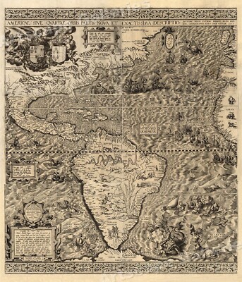
Buy It Now
$5.95 Shipping Condition: New Location: Las Vegas, United States The New World 1562 Size: 20" x 24" 51 cm x 61 cm) x Also Available in 24" x 28" from our eBay Store This is a great Classic Map originally ... morePublished circa 1562. This Map shows the America's as it was known in the 1500's. Includes texts in cartouche. Statements of dedication, coats-of-arms, ill. of allegorical f igure"Victoria" And ill. of sailing ships at sea and imaginary marine creatures. The wording on the map reads: Americae sive qvartae orbis partis nova et exactissima descriptio/ avtore Diego Gvtiero Philippi Regis Hisp. etc. Cosmographo; Hiero. Cock excvde 1562; Hieronymus Cock excude cum gratia et priuilegio 1562" This poster. Which evokes the vivid images of a simpler time, is a custom reproduction printed on 68lb Heavyweight Enhanced Matte Art Paper. This Historic Art Print is suitable for framing. Mounting or direct display on any wall! 000 Artscape Galleries/ Posters Past More Prints and Posters Available from our eBay Store! Shipping price includes delivery confirmation. We combine shipping for multiple purchases- add $1.00 for each additional poster. All posters are professionally packaged to ensure that they arrive safely and undamaged: Your poster is first rolled and inserted into a plastic sleeve before being placed into a Heavy-Duty mailing tube for delivery. We stand behind the quality of every poster. If you are not satisfied with your purchase. Please contact us within 30 days to arrange for either an exchange or a full refund. gsrx_vers_468(GS 6.4(468)
Buy It Now
$4.47 Shipping Location: Olney, United States This amazing rare vintage map from 1957 depicts the world during the spice trade era. It is a wonderful piece of history and a great addition to any collection. ... moreThe map is in excellent shape and shows the world as it was viewed over 60 years ago. The intricate details and colors make it a beautiful decorative piece as well. Perfect for any history buff or map enthusiast.
Buy It Now
$6.95 Shipping Location: Dover, United States Issued 1846, Paris by Delamarche. Mappe-Monde en deux Hemispheres. Early 19th century engraved map with original outline hand color. Original center fold ... moreas issued.
Buy It Now
$7.83 Shipping Location: Celina, United States Wear to cover, corners and edges, maps in great shape
Buy It Now
$4.95 Shipping Location: Dover, United States Attractive and detailed early 20th century color lithographed map.

Buy It Now
$29.85 Shipping Location: ASHTON-UNDER-LYNE, United Kingdom The item you are bidding on is a NEW Collectible NEW YORK CITY with World Trade Center and Region MANHATTAN NEW YORK CITY REGIONAL COASTLINE COMPLETELY ... moreHAND DRAWN& PAINTED IN WATERCOLOR Flat Heavy Laminated approx. 27 1/4 x 18 1/8 inches Unique Media Map These maps really are unique. Their colorful representation of an area really gives you a unique perspective on whatever state. Country or region is displayed on the map. Carefully inspect these maps and you will see a plethora of places to go and sites to see. Our customers like to study these maps for a number of reasons. First, they are so detailed, you will discover something new each time you look at it. Second, the interesting sites are all depicted with colorful drawings and icons that help you spot the place immediately. And finally, these maps are somewhat language independent. The drawings of the sites speak for themselves. This Unique Media Map is entirely hand-drawn and painted in a watercolor technique designed to create an original and sophisticated landscape graphic. Unique Media Inc. originated this novel style of three-dimensional mapping. It is a fresh innovation on the fascinating and centuries-old artform of bird's-eye-view pictorial maps. Our artistic illustration style coupled with our special interpretation of scale gives a real feeling for the layout and beauty of urban and natural environments. Whether applied to continental landmasses or to a city block. The Unique Media Perspective helps you visualize both the individual landmarks and overall landscape of the area. The geography comes alive and gives you a clear sense of orientation. Add to this the interesting, objective text and handy format and you have a reference that you can use time and time again. We take pride in our work. Thousands of hours of artwork and detailed research go into the creation of each title.

Buy It Now
Free Shipping Location: Pagosa Springs, United States Title: Mappemonde a l usage de l Instr.on, Author: Delisle. Guillaume, Year: 1808, Edition: 0.00, Size: 66x45cm, Condition: Very Good, Publisher: Dezuache, ... morePublication Loc: Paris, Pages: 1, Our Item# 34256, Large world map from Guillame Delisle. Updated by Philippe Buache and published in 1808. Shows the fledgling US with a pretty well-defined coast of Alaska, and more realistic descriptions of the Far East. Inset cartouche tells of the discoveries of Captain Cook and the Sandwich Islands. On very heavy white, laid paper. Blank verso. Centerfold as made, separating at bottom and reinforced. Some very minor toning spots noticeable on the reverse, some edge wrinkling. See scan for exact condition- this is a nice map in overall very good condition. Will rolled for shipping in a very heavy guage tube. Measurements are of the image, page size is larger. Absolutely guaranteed antique original map ca 200 years old. Contact: Guarantee: Payment: According to eBay rules. We accept PayPal for payment. 6.7% sales tax will be added for all Colorado deliveries. Shipping: PLEASE NOTE: We lose money on shipping- look at the postage when you get the package. Factor in the free private insurance(instead of charging you the high postal service ins rates) And see how much you paid. Please keep this in mind when giving stars for shipping costs. International Shipping: For shipment out of the USA. Items in value over $100 are shipped registered insured, which is why the high shipping fee. Even so, we lose money on shipping- look at the postage when you get the package, factor in the free private insurance(instead of charging you the high postal service ins rates) And see how much you paid. Please keep this in mind when giving stars for shipping costs. International Buyers– Please Note: Import duties. Taxes and charges are not included in the item price or shipping charges. These charges are the buyer's responsibility. Please check with your country's customs office to determine what these additional
Buy It Now
$7.00 Shipping Location: North Wales, United States 1897 ANTIQUE CENTURY ATLAS MAP OF THE WORLD-EXCELLENT DETAIL ORIGINAL ANTIQUE ATLAS MAP PLEASE SEE PHOTOS AS PART OF THE DESCRIPTION CONDITION: MAP IS ... moreIN GOOD CONDITION. SIZE: APPROXIMATELY 10.5" X 15" SHIPPING: U.S. FIRST CLASS RATE - $6.00 - ANY ITEM WHICH SELLS FOR OVER $100 WILL REQUIRE INSURANCE WE COMBINE SHIPPING FOR MULTIPLE WINS. THANK YOU FOR YOUR INTEREST IN OUR AUCTIONS!.
Buy It Now
$6.90 Shipping Location: Jasper, United States Known for being one of the oldest and most respected publishing houses in Germany, the Bibliographisches Institut specialized in authoritative reference ... moreworks. The map's condition is as shown in the pictures.
Buy It Now
$24.00 Shipping Location: Boones Mill, United States FLAWS, SEE BELOW AND PHOTOS. I've owned this for a decade and have thoroughly enjoyed it. Have not noticed any degradation since I've had it. Being very ... moreRobust, thick reinforced paper. Also Note that it's operation unrolling/pulling down/ out of its case is smooth and easy.
Buy It Now
$6.65 Shipping Location: Celina, United States See pictures some torn pages
Buy It Now
Free Shipping Location: Schertz, United States This is an Authentic / Original Antique Atlas Map. It is not *NEW* or in *NEW* condition, it was printed in the year indicated. We sell only Old Antique ... moreMaps, not prints, copies or posters. See Photo for best description, this is the actual map you will receive.

Buy It Now
$14.45 Shipping Location: Belvedere Tiburon, United States The World Map + World Ocean Floor Map National Geographic December 1981 This huge two-sided poster is in near mint condition. It has a little piece of ... moretape at 4 seam corners. It is 29" x 43" 313 Click on the red book icon and check our Ebay store Heart for Ethiopia for more good buys. We have many books and other items. They are arranged in categories. Most are $1 or $2. All proceeds go to Ethiopia to provide for development and child education in rural Ethiopia. Because we are raising money for charity no item will ever be reduced below $1. We give a combined shipping discount on all media items. Shipping for each additional media item is only $1.50. 100% Satisfaction Guarantee Terms: Payment is due at end of auction. If payment is not received within 7 days it will be reported as unpaid and the item will be relisted. Combined shipping and handling is available on multiple purchases made within a week. Books cannot be combined with other items as they are sent by media mail. Shipping for books is calculated using the shipping cost of the heaviest book plus $1.50 for each additional book. Media mail takes 5 to 14 days. It includes tracking. If you are satisfied with your purchase. Please leave positive feedback. Good feedback will quickly be left for you when payment is received. Prioity mail is available for an additional fee. If there is a problem with your item. Please email before leaving feedback and give us a chance to correct the problem. Email us for international shipping costs. Customs may be charged on international shipments. All customs charges are the responsiblity of the buyer and are not included in the selling price. Feel free to email us if you have any questions or concerns. Powered by The free listing tool. List your items fast and easy and manage your active items. Powered by The free listing tool. List your items fast and easy and manage your active items. Powered by The free listing tool. List your items fast and easy and manage your active items. Powered by The free listing tool.
Buy It Now
$6.65 Shipping Location: Celina, United States Cover not connected to binding, maps in good shape see pictures, atlas may be missing maps if it’s not pictures there is no guarantee it is in the book
Buy It Now
$6.95 Shipping Location: Dover, United States Issued 1860, Philadelphia by S. Augustus Mitchell. There are many variant issues of this map, with differing borders and interior details. Original center ... morefold as issued. Mid 19th century antique engraved map with original hand color.
Buy It Now
Free Shipping Location: Bellflower, United States ORIGINAL MAP - - STEINWEHR 1894 MAP. BLANK BACK THIS MAP HAS 3 HOLE PUCHES AS SEEN IN THE PICTURE. FOR SIZE THE MAP IS PHOTOGRAPHED NEXT TO A CARPENTERS ... moreSQUARE. SEE PIC FOR CONDITION. PHOTOS ARE OF THE ACTUAL ITEM YOU WILL RECEIVE.
Buy It Now
$11.85 Shipping Location: Dover, United States Issued 1772, Paris by Vaugondy. Late 18th century engraved map with attractive hand color. Original fold lines as issued.
Buy It Now
$3.75 Shipping Location: United States Fine antique 1866 handcolored map, titled in fancy antique lettering, Chart of Ocean & Continental Basins, Ocean Currents and Co-Tidal Lines, with inset ... moreRain Chart. The superb handcoloring is period to the map, this is before color printing.
Buy It Now
$6.00 Shipping Location: Corunna, United States This map is an original from "The Century Atlas Of The World" printed in 1898.
Buy It Now
Free Shipping Location: Japan Appreciate your reading until end.
Buy It Now
Free Shipping Location: Schertz, United States This piece was removed from an 1849 MITCHELL'S SCHOOL ATLAS and is in good condition. The map is not " new " or in " new " condition, it was printed in ... more1849. The map is dated. Study the photos carefully, this is the actual map you will receive.
Buy It Now
Free Shipping Location: East Lansing, United States
Buy It Now
$3.79 Shipping Location: Northampton, United States Perfect for framing. Single sheet. Minor wear, light soil.
Buy It Now
Free Shipping Location: Schertz, United States This is an Authentic / Original Antique Atlas Map. It is not *NEW* or in *NEW* condition, it was printed in the year indicated. We sell only Old Antique ... moreMaps, not prints, copies or posters. See Photo for best description, this is the actual map you will receive.
Buy It Now
$124.35 Shipping Location: Arlington, United States Alexander Keith Johnston's. RARE ORIGINAL FOLIO MAP FROM.
Buy It Now
$7.20 Shipping Location: Bradenton, United States Pulled from an early 1960's Hammonds Globemaster World Atlas. Rough edge where pulled from book.
Buy It Now
$10.80 Shipping Location: Des Allemands, United States This Hammond New supreme World Atlas is dated 1954. hard cover book in good condition. Published by Garden City Books with 176 pages and about 9 1/2 x ... more10 1/2 inches. Normal wear to edges. Some light discolorations on end page as noted, clean pages and solid binding. Numerous color maps of countries, State maps, index of the United States with city and county stats, population figures and more.
Buy It Now
Free Shipping Location: Schertz, United States This is an Authentic / Original Antique Atlas Map. It is not *NEW* or in *NEW* condition, it was printed in the year indicated. We sell only Old Antique ... moreMaps, not prints, copies or posters. See Photo for best description, this is the actual map you will receive.
Buy It Now
$7.00 Shipping Location: North Wales, United States 1864 ANTIQUE JOHNSON ATLAS CHART-WORLD OCEAN CURRENTS, METEOROLOGY-HAND COLORED ORIGINAL ANTIQUE ATLAS MAP PLEASE SEE PHOTOS AS PART OF THE DESCRIPTION ... moreCONDITION: MAP IS IN GOOD CONDITION. SIZE: APPROXIMATELY 10" X 13" SHIPPING: U.S. FIRST CLASS RATE - $7.00 - ANY ITEM WHICH SELLS FOR OVER $100 WILL REQUIRE INSURANCE WE COMBINE SHIPPING FOR MULTIPLE WINS. THANK YOU FOR YOUR INTEREST IN OUR AUCTIONS!.
Buy It Now
Free Shipping Location: Schertz, United States This is an Authentic / Original Antique Atlas Map. It is not *NEW* or in *NEW* condition, it was printed in the year indicated. We sell only Old Antique ... moreMaps, not prints, copies or posters. See Photo for best description, this is the actual map you will receive.
Buy It Now
$6.95 Shipping Location: Dover, United States The World in Hemispheres. Issued 1895, Philadelphia by M. Bradley & Bros. Large oversize late 19th century map with original hand color. Original center ... morefold as issued.
Buy It Now
$6.90 Shipping Location: Jasper, United States Known for being one of the oldest and most respected publishing houses in Germany, the Bibliographisches Institut specialized in authoritative reference ... moreworks. The map's condition is as shown in the pictures.
Buy It Now
Free Shipping Location: Lake Elsinore, United States Era of Exploration, An Hispanic History 1400-1600.
Buy It Now
$4.13 Shipping Location: Nashville, United States Up for sale is an original antique 1865 hand water colored EASTERN HEMISPHERE Map. Map would make a wonderful gift. In very nice antique condition.
Buy It Now
$8.30 Shipping Location: Celina, United States See pictures, wear to cover corners and edges, see pictures, tears to some pages, a couple maps have tears
Buy It Now
$15.86 Shipping Location: Mount Cotton, Australia As a traveller cruises the east coast of the United States, for example, the declination varies from 16 degrees west in Maine, to 6 in Florida, to 0 degrees ... morein Louisiana, to 4 degrees east in Texas. A Chart of Magnetic Curves of Equal Variation by Peter Barlow, engraved by G Aikman for A&C Black, Edinburgh c1854.
Buy It Now
Free Shipping Location: Schertz, United States This is an Authentic / Original Antique Atlas Map. It is not *NEW* or in *NEW* condition, it was printed in the year indicated. We sell only Old Antique ... moreMaps, not prints, copies or posters. See Photo for best description, this is the actual map you will receive.
Buy It Now
$9.83 Shipping Location: Astoria, United States MAP 1922 CRAM’S HOME LIBRARY ATLAS WWI SYNOPSIS USED: SOME WRINKLED PAGES. A COUPLE MARGIN TEARS. Attic find. Combined items reduces total shipping cost. ... moreI will combine into a 1 package weight shipping. I use cardboard to prevent bending.
Buy It Now
Free Shipping Location: San Antonio, United States This Map was removed from a 1902 Atlas and is in good acceptable condition. Including Hundreds of RareCivil War. This map is not new or in new condition, ... moreit was printed in 1902. Study the photos carefully, this is the actual map you will receive.
Buy It Now
Free Shipping Location: North Wales, United States 1838 ANTIQUE SMILEY'S ATLAS MAP-ATLANTIC OCEAN-HAND COLORED ORIGINAL ANTIQUE ATLAS MAP PLEASE SEE PHOTOS AS PART OF THE DESCRIPTION CONDITION: MAP IS ... moreIN GOOD CONDITION. SIZE: APPROXIMATELY 9.5" X 12.5" SHIPPING: U.S. FIRST CLASS RATE - FREE SHIPPING - ANY ITEM WHICH SELLS FOR OVER $100 WILL REQUIRE INSURANCE WE COMBINE SHIPPING FOR MULTIPLE WINS. THANK YOU FOR YOUR INTEREST IN OUR AUCTIONS!.
Buy It Now
$6.95 Shipping Location: Bar Harbor, United States Giovanni Leardo. The Bible, for example, was of central importance in describing the Holy Land and environs. In the map drawn by the Italian artist Giovanni ... moreLeardo (Venice 1452-53), the world is disc-shaped, surrounded on all sides by water.
Buy It Now
Free Shipping Location: Four Oaks, United States 4 Africa Map.
Buy It Now
Free Shipping Location: Schertz, United States This is an Authentic / Original Antique Atlas Map. It is not *NEW* or in *NEW* condition, it was printed in the year indicated. We sell only Old Antique ... moreMaps, not prints, copies or posters. See Photo for best description, this is the actual map you will receive.
Buy It Now
$5.61 Shipping Location: Issaquah, United States
Buy It Now
$30.00 Shipping Location: Paris VI, France In 1541, on behalf of Charles V, he built two globes, terrestrial and celestial. He then settled in Duisburg in 1552. The brass of his Atlas was then ... moreused by Judocus Hondius. He is responsible for the projection used in nautical charts.
Buy It Now
$30.00 Shipping Location: Paris VI, France Wall map, planisphere in colors, edited by PERCEVAL, middle XXe Century. Edition : créations Perceval, éditions de l'Ecole, Paris, middle XXe Century.
Buy It Now
$7.20 Shipping Location: Bradenton, United States 1 side features the South Polar Regions and the other side - the Atlantic Ocean.
Buy It Now
$25.00 Shipping Location: Atlanta, United States Uncolored engraving highlighted by the six wind heads at the map's boarders. Date: ~1598. (The Whole World).
Buy It Now
$6.95 Shipping Location: Dover, United States Issued c. 1849, Glogau, Germany by Flemming. Keys at bottom corners show by nationality the domain and regions where it has spread. Mid 19th century lithographed ... moremap with original outline hand color.
Buy It Now
$14.50 Shipping Location: Belton, United States Reverse shows text.
Buy It Now
$3.79 Shipping Location: Northampton, United States Perfect for framing. Single sheet. Minor wear, light soil.
Buy It Now
Free Shipping Location: Effingham, United States
Buy It Now
$6.65 Shipping Location: Celina, United States See pictures, binding coming loose, not positive on year, maps are in good shape, atlas may be missing maps if it’s not pictures there is no guarantee ... moreit is in the book
|
|
|
In
|
Vintage 1937 World War WWII Era Atlas City Map Central Seattle WA Washington OLD
A Wonderful Gift! Vintage 1937 WWII Era Atlas City Map Seattle WA Washington Great Gift! Great OLD Map from the"COLLIER'S WORLD ATLAS& GAZETTEER" Copyright 1937 World War II Era 76 Years Old! The Actual Page! NOT a Copy! Central Seattle. Washington(Contact Us For More Scans) This Map Measures About 10 3/4 x 14 1/8" Map Shows Points of Interest; City Hall. Seattle Ball Park, Lake Washington Canal, Yacht Club, University Golf Links, Docks, Stadium, Elliott Bay, Cemeteries, Ferry Routes, Many Businesses. Etc. Very Educational. See what the City used to look like! WWII Black& White Will look great Matted& framed A Nice Gift! A GREAT House Warming Gift! The Perfect Anytime Gift! Teachers& Politicians LOVE Them! Super For a Local Business or Office! Shipping by 1st Class Mail or Priority Mail We Will Combine Shipping ... moreon Up To 4 Maps for the same shipping fee Email Us With Any Questions or For an International Shipping Quote Check out my other items! Be sure to add me to your favorites list! Thanks For Looking! International Buyers– Please Note: Import duties. Taxes, and charges are not included in the item price or shipping cost. These charges are the buyer's responsibility. Please check with your country's customs office to determine what these additional costs will be prior to bidding or buying. Certain images and/or photos used in this template are the copyrighted property of JupiterImages and are being used with permission under license.
|
|
|
Antique Map Mountains and Rivers of the World 1873 Gray's Atlas Color
This map is in very good condition. Map measures 28 x 17 inches and is suitable for framing. The atlas title page shown is not included in the auction and is shown for the purpose of authentication only. You are bidding on a page from a 1873 atlas. This map will be shipped wrapped in plastic and in a cardboard shipping tube. Thanks for looking and please be sure to visit my other auctions for more antique and vintage maps. Ads, magazines, post cards, books, and more. Powered by
|
|
|
Exceptional 1875 Original Antique OCEAN TRADE ROUTES Nautical Map WORLD US Globe
A fine adornment of World History. Impressive on any Home or Office Wall. Imaginative& Creative Gift. 1875 Map of Principal Ocean Trade Routes of The World Harper& Brothers Engraved Map. Original 1875. 137-ys-old. Principal Ocean Trade Routes& Transcontinental Railroad. Map is in Good/Very Good condition: No writings or marks. Mild foxing. Some fraying. Single fold as issued. Not a reproduction. Original Map of the 1875 Edition of"Harper's Geography with Maps Prepared Expressly For This Work by Eminent American Artists. by Harper& Brothers, New York, 1875, and Entered According to Act of Congress in the Year 1875 by Harper& Brothers in the Office of the Librarian of Congress in Washington; a copy of the Title Page of which is Included. I sell only Original Maps: No copies or reproductions. View my other items ... morefor more antique maps. Impressive on Any Home or Office Wall. Map Dimensions: 11.5" x 18.5" Great for Nautical History as Map shows Principal Ocean Routes of 1875. Naming Each Route and Length in Days. The Auction is for the Map Itself. A Frame is NOT included. The Framed Map Pictured is a Personal 1875 Harper& Brothers Map Featured to Show the Beauty of the Maps when Framed. Free Shipping Special. All Credit& Debit Cards along with Electronic Checks accepted through Paypal. Please email with any questions. Greetings from Historical Savannah. Georgia; founded 1733. Some. To beautify their halls, parlors, chambers, galleries, studies, or libraries.liketh, loveth, getteth, and useth maps, charts, and geographical globes. John Dee, Advisor to Elizabeth I. Press The Link Below To View My Collection. Powered by The free listing tool. List your items fast and easy and manage your active items.
|
|
|
World (Mercator's) Map: LARGE; w/ National GNPs, Trade; Much More Authentic 1905
Large Map. With much Detailed Information Printed in the Margins- 1905 The World on Mercator's Projection Satisfaction Guaranteed This offering is for a Large Color Map of the World on Mercator's Projection. 28" x 18" including printed borders) The map was included in a 1905 Atlas of Scott County. Iowa; published by the Iowa Publishing Company, of Davenport. I believe the map was actually prepared by George F. Cram& Co. of Chicago, and that the Iowa Publishing Company simply added the statistics printed in the margins and the"Ears of Corn" border. Printed on the left margin are" Railroads of the World(by continent and country) and" Telegraphs of the World(by country) Printed on the right margin(shown in second scan below) are"Dimensions of the Earth" title and first line of text is not shown ... moredue to scanner size limitation. The rest can. I believe, be easily read. Printed on the top margin are: Countries of the World along with their: Capitals. Area. Population, Commerce with the US, National Debt(total and per capita) Revenue and Expenditures. Condition: Very Good. The map is split at the fold-from the bottom to about five inches up from the bottom. It has been mended from the rear with archival document tape(which never yellows) Printed on a Single Sheet with a fold in the center(as issued) Map is too large for my 12.5" by 17.5" tabloid scanner so it was scanned in two passes and then combined with image editing software. There is no break in the map-it is printed on a single sheet(blank on the reverse) which measures about 29.25" x 17.75" Ears of corn border is intact all around the map but cropped on the north in the scan below due to scanner size. Actual size. Including the printed borders is about 28" by 18" Sheet size is about 29.25" x 18.25" close-up below) Copyright and Publisher shown below for reference. The"Ears of Corn" Border surrounds this map completely-although cropped in the first scan above. Pow
|
|
|
*Vintage 1943 World War WWII Atlas City Map Philadelphia, PA Penn Pennsylvania*
Vintage 1943 World Atlas City Map Philadelphia. PA Penn. A Wonderful Gift! Great OLD Map from the"COLLIER'S WORLD ATLAS& GAZETTEER" Copyright 1943 World War II 70 Years Old! The Actual Page! NOT a Copy! Philadelphia. Pennsylvania(Contact Us For More Scans) This Map Measures About 10 3/4 x 14 1/8" Map Shows Points of Interest. Parks, Art Museum, The Schuylkill River, Eastern State Penetentiary, Hospitals, Schools, Churches, Hotels, Post Office, Eagles Temple, University of Pennsylvania, Reading Railroad Terminal, City Hall, Railroads, Many Businesses Etc. Very Educational. See what the City used to look like! WWII Black& White Will look great Matted& framed(see all photos) A Nice Gift! A GREAT House Warming Gift! The Perfect Anytime Gift! Teachers& Politicians LOVE Them! Super For a Local Business or Office! ... moreShipping by 1st Class Mail We Will Combine Shipping on Up To 4 Maps for the same shipping fee Email Us With Any Questions or For an International Shipping Quote Check out my other items! Be sure to add me to your favorites list! Thanks For Looking! International Buyers– Please Note: Import duties. Taxes, and charges are not included in the item price or shipping cost. These charges are the buyer's responsibility. Please check with your country's customs office to determine what these additional costs will be prior to bidding or buying. Certain images and/or photos used in this template are the copyrighted property of JupiterImages and are being used with permission under license. 2:gb.RcmdId ViewItemDescV4,RlogId p4%60bo7%60jtb9%3Fuk.rp*ac%3E2%3Agb-13d82cfbf84-0xf8-
|
|
|
1964 New York State Parks Map World's Fair
New York State Parks- a Guide to over 100 Parks from Mautauk to Niagara Falls- See the New York World's Fair 1964-1965 map. This map is in excellent condition. Please view the photos. I tried to take the pictures to show condition. If by chance. You need more photos or have any questions, please email and I will accommodate asap. Please check out Grandma Jaree's Emporium for estate sale finds. All at awesome prices. New items listed daily, so be sure to add me to your favorites list! Although most of my items have free shipping; I gladly combine shipping on multiple purchases where applicable. Paper items are shipped in a plastic sleeve and backed by cardstock for lower cost shipping. Cardboard backers can be substituted for an additional 50 cents. Shipping is done Monday through Friday. Once payment is received. International bidding ... moreis accepted. Please email for shipping quote. If you are not satisfied with your product. You may return it within 14 days of receipt for a full refund. If there is a problem, we can work it out before negative feedback is given. I strive to make every customer happy. Powered by The free listing tool. List your items fast and easy and manage your active items.
|
|
|
Vintage 1924 Upper Manhattan Bronx Atlas Map NY New York City World War WWI Era
Vintage 1924 Upper Manhattan& Bronx Atlas City Map NYC New York City A Wonderful Gift! Great OLD Map from the"COLLIER'S THE NEW ENCYCLOPEDIC ATLAS& GAZETTEER OF THE WORLD" The Atlas Is Copyright 1924 89 Years Old! The Actual Page! NOT a Copy! Upper Manhattan& The Bronx. New York City, NY(Contact Us For More Scans) On the other side is The Index of Streets This Map Measures About 10 1/4 x 15 1/8" Map Shows Points of Interest. The East, The Harlem& The Hudson Rivers, Emigrant Hospital, The University of The City of New York, Central Park, The Bronx, Polo Grounds, Ball Grounds, Columbia University, Convent of The Sacred Heart, Deaf and Dumb Institute, Fort George, New York& Harlem Railroad, Hells Gate, Etc. Very Educational. See what the City used to look like! On The Back There Is a Guide To Streets In ... moreNorthern& Southern Manhattan. Points of Interest& Piers It Will Look GREAT When Matted& Framed Post World War I Black& White A Nice Gift! A GREAT House Warming Gift! The Perfect Gift! It Will Look GREAT Matted& Framed This Map Can Line Up& Be Framed With The"Lower Manhattan" Map From The Same Year! Teachers& Politicians LOVE Them! Super For a Local Business or Office! Shipping by 1st Class Mail We Will Combine Shipping on Up To 4 Maps for the same shipping fee Email Us With Any Questions or For an International Shipping Quote Check out my other items! Be sure to add me to your favorites list! Thanks For Looking! International Buyers– Please Note: Import duties. Taxes, and charges are not included in the item price or shipping cost. These charges are the buyer's responsibility. Please check with your country's customs office to determine what these additional costs will be prior to bidding or buying. Certain images and/or photos used in this template are the copyrighted property of JupiterImages and are being used with permission under license.
|
|
|
Vintage 1943 Upper Manhattan Bronx Atlas Map NY New York City World War WWII Era
Vintage 1943 Upper Manhattan& Bronx Atlas City Map NYC New York City A Wonderful Gift! Great OLD Map from the"COLLIER'S WORLD ATLAS& GAZETTEER" Copyright 1943 70 Years Old! The Actual Page! NOT a Copy! Upper Manhattan& The Bronx. New York City, NY(Contact Us For More Scans) This Map Measures About 10 3/4 x 14 1/8" Map Shows Points of Interest. Yankee Stadium. The East, The Harlem& The Hudson Rivers, Hell Gate, The Botanical& Zoological Gardens, Central Park, The Bronx, Polo Grounds, Fordham University, Palisade AmusementPark, Etc. Very Educational. See what the City used to look like! On The back There Are Photos Of The New York Medical Center& Rockefeller Center It Will Look GREAT When Matted& Framed World War II Black& White A Nice Gift! A GREAT House Warming Gift! The Perfect Gift! It ... moreWill Look GREAT Matted& Framed This Map Can Line Up& Be Framed With The"Lower Manhattan" Map From The Same Year! Teachers& Politicians LOVE Them! Super For a Local Business or Office! Shipping by 1st Class Mail We Will Combine Shipping on Up To 4 Maps for the same shipping fee Email Us With Any Questions or For an International Shipping Quote Check out my other items! Be sure to add me to your favorites list! Thanks For Looking! International Buyers– Please Note: Import duties. Taxes, and charges are not included in the item price or shipping cost. These charges are the buyer's responsibility. Please check with your country's customs office to determine what these additional costs will be prior to bidding or buying. Certain images and/or photos used in this template are the copyrighted property of JupiterImages and are being used with permission under license.
|
|
|
NEW YORK authentic World War II Vintage Map genuine 74 years old made in 1939
This image is enlarged to show representative detail. NEW YORK Authentic 74-Year-Old Vintage Map Made During World War II FREE SHIPPING ANYWHERE IN THE USA! Printed in 1939. This is a beautiful, 74-year-old map of the State of New York. It measures about 10 3/4 by 14 1/4 inches(about 27 by 36 cm. and is in Fine condition. The map contains a wealth of detail including latitude and longitude, topographical features, counties, cities and villages, routes of old railroads, and more. A detailed index to cities and villages is printed in the margin. This is a guaranteed genuine vintage map! Ideal for genealogy or historical research. This map was printed on a single sheet of stock and bound whole in an antique book. There are no folds or creases, and the paper is clean and not brittle. A similar map is printed on the reverse. Highly suitable for ... moreframing, this map would look great in your office, library, den or study. It is similar to many of the maps sold in expensive mail-order catalogues and department stores, with one important difference: this is an actual antique. NOT a modern reproduction. A great investment. This map is certain to appreciate in value over time. Please ask all questions before making your purchase. FREE SHIPPING anywhere in the USA by USPS First Class Mail. Priority and Express services also available. Shipped rolled in a sturdy tube. cwag39b
|
|
|
World War II WWII Map Aerial Photograph War Department Field Manual FM21-25 1944
Elementary Map and Aerial Photograph Reading War Department Field Manual FM21-25 Publisher: U. S. War Department; FM 21-25 edition(1944) 116 Pages Issued to World War II Veteran Roy Dimitri Parsons who later went on to become a famous artist; proceeds will go to his widow. In very good condition Please see pictures for further details Bin-9(Allyn P.
|
|
|
DETROIT MICHIGAN authentic World War II vintage Map genuine 74 years old - 1939
DETROIT. MICHIGAN Authentic 74-Year-Old Vintage Map FREE SHIPPING ANYWHERE IN THE USA! Printed in 1939. This is a beautiful, 74-year-old map of the city of Detroit. It measures about 10 3/4 by 14 inches(about 27 by 36 cm. and is in Fine condition. The map contains a wealth of detail down to the street level, and includes old landmarks such as public buildings, hotels, schools, theaters, train depots, parks, cemeteries, US and State Highways(no Interstates yet, of course) and much more. This is a guaranteed genuine antique map! Ideal for genealogy or historical research. This map was printed on a single sheet of stock and bound whole in an antique book. There are no folds or creases, and the paper is clean and not brittle. Highly suitable for framing, this map would look great in your office, library, den or study. It is similar to many of ... morethe maps sold in expensive mail-order catalogues and department stores, with one important difference: this is an actual antique. NOT a modern reproduction. A great investment. This map is certain to appreciate in value over time. Please ask all questions before making your purchase. FREE SHIPPING anywhere in the USA by USPS First Class Mail. Priority and Express services also available. Shipped rolled in a sturdy tube. cwag39a 36
|
|
|
ASIA authentic World War 2 Vintage Map genuine 74 years old made in 1939
ASIA Authentic 74-Year-Old Vintage Map Created During World War II FREE SHIPPING ANYWHERE IN THE USA! Printed in 1939. During the early days of the Second World War, this is a beautiful, 74-year-old color map of the Asian continent. It measures about 27 by 35 cm. about 10 1/2 by 14 inches) and is in Fine condition. This map is very detailed showing latitude and longitude, topographical features, countries, cities, and more. An index to cities is printed in the margin. This is a guaranteed genuine vintage map! Ideal for genealogy purposes. Not to mention being highly decorative, it was printed on a single sheet of stock and bound into an antique book. There are no folds, creases, marks or stains. A similar map of the USSR on a larger scale is printed on the reverse. Highly suitable for framing, it would look gorgeous in your office, den, library ... moreor study. It is similar to many of the maps shown in expensive mail-order catalogues, only this is an actual antique. NOT a modern copy or reproduction! An excellent investment. This map is certain to appreciate in value over time. Please ask all questions before making your purchase. FREE SHIPPING anywhere in the USA by USPS First Class Mail. Priority and Express services also available. Shipped rolled in a sturdy tube. We ship worldwide! cwag39b
|
|
|
C-USA 1973 Canada 10 Dollars PR World Map
1.4454 oz actual silver weight. Mirrored fields with frosted devices. Welcome to Collector-USA: We are proud to open a branch in the south. Collector-USA now will be shipping coins out of Nokomis. Florida along with Bozeman, Montana. This is the same great company with the same great service. If you ever have any problems please let us know so we can help solve it. Our Guarantee: We GUARANTEE that any non-certified coin or coins that you purchase from us will grade at least the same grade as purchased or higher through any of E-Bay's approved grading services! This guarantee does not apply to coins which we label as cleaned or having other problems. This allows you to buy our non-certified coins with complete confidence. All non-certified coins were graded by Dale L. Williams. A previous grader for PCGS, located in Newport Beach, CA. ... moreDale was a finalist in the World Series of Grading. Collector-USA wants you to be happy with the coins that you get from us. If for any reason you do not like a coin you get from us or if it just does not fit your collection, please return it for a full refund of the purchase price. If you do not hear from us concerning any problem you may have, please contact us at 406-586-0469. Shipping Policy: All shipping in the USA is free to our customers. We try our best to ship everything within 24 hours of the purchase. A lot of the time we get the purchases out the same business day. Our Post Office closes at 12:00(Noon) on Saturday. We usually leave by 10:00 AM on Saturday. Orders after 10:00 will go out on Monday. Virtually all coins are shipped through the USPS with tracking numbers. Every coin is insured. Either through Collector-USA or the USPS. Lost items are paid for in a timely manner. International Shipping: If you have a preferred method of international shipping please contact us. We will try to help. We usually ship international shipments through the USPS. We ship either Registered or Express Mail. Registered Mail is in the vicinity of $12 plus the weight of the package and
|
|
|
1887 PRINCIPAL HIGH BUILDINGS OLD WORLD IN 1887 Antique Cram Map
FREE SHIPPING* WE SELL THE ORIGINAL ITEMS NOT COPIES OR REPRODUCTIONS* REVIEW THE PICTURES- THESE MAPS ARE OVER 125 YEARS OLD WILL HAVE SOME PROBLEMS. FOXING DISCOLORATION AND TEARS ALONG THE EDGES. MOST OF THE MAPS WILL LOOK GOOD WITH PROPER MATTING ETC A SAMPLE PICTURE SHOWING A MAP MATTED WITH BLACK AND WHITE MATS IS INCLUDED IN THE LAST PICTURE THIS PICTURE IS NOT INCLUDED IN THE AUCTION OF THIS ITEM 1887 PRINCIPAL HIGH BUILDINGS OLD WORLD IN 1887 Antique Cram Map M 01- HIGH BUILDING OF THE WORLD 1 PAGE FROM 1887 CARM ATLAS SHOWING THE 78 HIGH BUILDING OF THE WORLD- TALLEST WAS THE WASHINGTON MONUMENT AT 555 FEET- THE LOWEST WAS TEMPLE OF THE ILLISSUS ATHENS 25 FEET SOLD AS PICTURED- SIZE IS ABOUT 13.5 X 11.5 M 01 Powered by The free listing tool. List your items fast and easy and manage your active items.
|
|
|
Western Hemisphere 1853 original Boynton antique hand color World map
Western Hemisphere 1853 original Boynton antique hand color World map WESTERN HEMISPHERE issued Boston: 1853. Engraved by Boynton. Fine original antique World map. With original hand color, printed on quality paper which retains its inherent structural flexibility and soundness. In Very Good or better condition[note: we grade very conservatively and always seek to disclose any noteworthy flaws] The printed area remains pleasing. A nice impression that would look great framed. Sheet measures c. 5 1/8" W x 7" H. Engraved area measures c. 4 3/8" W x 6 1/8" H. 35169] note: All old sheets of printed paper possibly have short edge splits. Each sheet has existed for a very long time and has probably been handled repeatedly in the course of it's existence. It has a history unique to it as an object. Most of the time any edge ... moresplits are short. Minor, insignificant and have been closed- either long ago or more recently with small pieces of archival tape. Most often these splits are trivial and easy to overlook visually. Basically, they would not significantly affect the piece adversely. The item is offered as seen. Please look carefully and make your decision knowing this antique image is nice. But it is not in perfect"like new" condition. However, with whatever flaws it possesses, it remains entirely worthy of ownership and inclusion in any related collection. We feel it will prove very pleasing to its new owner. We stand behind everything we sell. Everything we offer is guaranteed to be an authentic original antique item as described. We do not sell modern reproductions. Please visit our. We happily accept PayPal! WE OFFER FLAT RATE SHIPPING WORLD WIDE! Please request an invoice before paying for multiple items so that we can ensure that you are not overcharged for shipping! To receive our flat rate shipping rates you must request or wait for an invoice. We can no longer refund excess shipping payments if you do no
|
|
|
1882 Antique Copper Plate Map RELIGIONS of the WORLD 13
Auction Wizard 2000 Listing Template- AW2KLOT#6074 tincuptom Auctions 1882 Antique Copper Plate Map RELIGIONS of the WORLD 13 Over 128 Year Old Copper Plate Map Original 1882. not a reproduction H. H. Hardesty Map Measures 10 3/4 x 14 1/2 inches Good Condition The USA Shipping is First Class mail. View my other listings for more antiques. Shipping and handling in the USA is $0.00. Payments are due in 7 day. You may pay by Paypal only. Please E-mail for International Shipping rates.
|
|
|
Vintage 1914 World War WWI Atlas City Map Detroit, Michigan MI /Windsor Ontario
Great Gift! Vintage 1914 WWI Atlas City Map Detroit. Michigan MI Great OLD Map from the COLLIER'S"THE NEW ENCYCLOPEDIC ATLAS& GAZETTEER OF THE WORLD" Copyright 1914 99 Years Old! The Actual Page! NOT a Copy! Detoit. Michigan(Contact Us For More Pictures) This Page Measures About 10 1/4 x 15 1/8" The Map Measures About 9" x 12" Map Shows Points of Interest. The Detroit River, Windsor Ontario Canada, Micigan Central Railroad Depot, Parks, Cemeteries, Ferries, House of Correction, City Hall, Public Bath House, U.S. Light House, Etc. Etc. Etc. On The Other Side Is a Small Map of Dublin. Ireland and Environs It Measures About3 5/8" x 3 1/4" Very Educational. See what the City used to look like! World War I Black& White Will look GREAT Matted& Framed(see all pics) A Nice Gift! A GREAT House Warming ... moreGift! The Perfect Gift! Teachers& Politicians LOVE Them! Super For a Local Business or Office! Shipping by 1st Class or Priority Mail We Will Combine Shipping on Up To 4 Maps for the same shipping fee Email Us With Any Questions or For an International Shipping Quote Check out my other items! Be sure to add me to your favorites list! Thanks For Looking! International Buyers– Please Note: Import duties. Taxes, and charges are not included in the item price or shipping cost. These charges are the buyer's responsibility. Please check with your country's customs office to determine what these additional costs will be prior to bidding or buying. 1.RcmdId ViewItemDescV4,RlogId p4%60bo7%60jtb9%3Fuk.rp73%28b0g%60%60%3E1-13d845b0a2b-0xfa-
|
|
|
Vintage 1914 World War WWI Atlas City Map Chicago, IL Illinois OLD 2 Pgs. L@@K!
A Wonderful Gift! Vintage 1914 WWI World Atlas City Map of Chicago. IL OLD 2 Pages Great OLD Map from the COLLIER'S"THE NEW ENCYCLOPEDIC ATLAS& GAZETTEER OF THE WORLD" The Atlas Is Copyright 1914 99 Years Old! The Map Is Copyright 1903 by The J.N. Matthews Co. Buffalo, N.Y. 110 Years Old! The Actual Pages! NOT a Copies! Chicago. Illinois(Contact Us For More Scans) The Pages Measure About 10 1/4 x 15 1/8" The Maps Measure About 8 5/8" x 13 1/2" 8 5/8" x 7 5/8" Frame Them Together Or Singly Maps Show Points of Interest. Lake Michigan, Union Stock Yards, Many Parks, Chicago River, Electric Fountain, Lincoln Monument, U.S. Life Saving Station, Bridwell Workhouse, Cook County Normal School, Park Manor Station, Etc. On Page 2 Is A List Of The Principal Streets Very Educational. See what the City used to ... morelook like! World War I Black& White Will look GREAT Matted& Framed A Nice Gift! A GREAT House Warming Gift! The Perfect Anytime Gift! Great For Genaeological Purposes! Teachers& Politicians LOVE Them! Super For a Local Business or Office! Shipping by 1st Class or Priority Mail We Will Combine Shipping on Up To 4 Maps for the same shipping fee Email Us With Any Questions or For an International Shipping Quote Check out my other items! Be sure to add me to your favorites list! Thanks For Looking! International Buyers– Please Note: Import duties. Taxes, and charges are not included in the item price or shipping cost. These charges are the buyer's responsibility. Please check with your country's customs office to determine what these additional costs will be prior to bidding or buying. Certain images and/or photos used in this template are the copyrighted property of JupiterImages and are being used with permission under license.
|
|
|
NEW Crocodile Creek World Cities Map Placemat
| | | World Cities Map Placemat. Manufacturer: Crocodile Creek. Manufacturer ID: 2820-7. SKU# CR2820-7 This item normally ships in 1 days Buy it Now Price: 3.79. Description. Have fun eating and learning at the table with World Cities Map educational placemat from Crocodile Creek! This placemat is made of durable PVC free and polypropylene. Cleaning by washing it with mild soap. No scrubbing. It meets all the US and European safety standards. Details. Recommended for 12 months and up, Conforms to or exceeds U.S. and European safety standards, About Us The COMFY BABY ON THE GO. Started on June 2009. With an experience of 10 years in retail and customer service, we decided to take advantage of our skills and start a children"s store. We know what it means to make a customer happy and in addition, it is nice to not forget the wonderful ... moreworld of toys and how beautiful it is to be a child and be surrounded by toys. So. What we did was to open this store with children in mind and for the children, whether they are at home or on the go. We carry products for babies, toddlers and grown-ups. Our staffed animals can be gifted for any occasion, regardless of age. All our products are kept into a smoke free and pet free environment. We only carry good brands and this means quality. We are an authorized Gund. Haba, Spielstabil, Vamplets, Kids Preferred, Rocket USA, Baby Sherpa, Daydream Toys and Grobag dealer and guarantee all our products are brand new and with the original tag, and they are shipped to us directly from the manufacturer. We check all items before packing to make sure they meet all standards of a new product. We are also very happy to make available to you green organic toys: plush animals and stuffed animals. We retail Miyim. Kallisto, Lana, all those being part of the organic family. If you're heading to a baby shower and you need a beautiful, environmentally friendly gift, this store is for you. We are sure you'll find something to fill your needs. Our customers satisfaction is very important t
|
|
|
Vintage China Atlas/Map from the School & Library Atlas of the World 1965
CHINA" PAGE 168 INDIA(2 PLATES) PAGE 167 1 full page: Page 167 and 168(BACK TO BACK) Book page measurements are 21-1/2" high x 15" wide Carefully r emoved from the- School and Library Atlas of the World Printed and Bound in the United States of America by the School and Library Publishing Company Sycamore. Illinois Library of Congress Catalog Card Number: Map 62-216 Framable measurements would be approx. be 20" x 14" This map is in on 2 pages and could be framed in 2 frames side by side. I'm showing the cover and title for your information only. not included) Please ask any questions regarding before purchasing. There is plenty of surrounding border for matting purposes. Some of the pages have some may have water spots. And some pages have faired better than others, all and all they have survived almost 50 years. ... moreMost of the age on the pages give the maps a well worn. Aged appearance. The colors are vibrant and the maps are still readable and framable. I will be posting more maps of states and countries. If you purchase more than one map. I will combine shipping. Please ask questions. Thank you. Note: One piece of tape on side of page 77 If you see a buy it now at the top click the BUY IT NOW button to get your purchase quicker. Note: This original antique map gives you an opportunity to examine in exquisite detail a piece of history. If you are interested in the past of this country and its people or have a desire to study where your family may have come from. Then this map gives you a rare look as the area was years ago. Once matted and framed, this map would make a perfect gift for a family member or friend. Most maps we sell come from atlases that were damaged and beyond repair. The maps often had a canvas book binding tape mounted on back along the center fold. Please if you are unhappy with your purchases. Please contact us before leaving feedback. Thank you.
|
|
|
Excellent 220mm world globe bronze stand earth map spin
Thanks for your browse I'm glad to introduce this. From the pictures, you could see it is very nice, high collection or as a gift to your friend! bless you good luck and good every day! Shipping and handling: The package need handing time 2 work days after your payment affirm;Usually the package shipping by Air Mail by Post Office about 15~25work days. If have delay.Sometimes may delay one more week,as for your Country Customhouse)please contact me in time.If you want Quick Shipping way 5~8days,please contact me change Express Service. Combined Shipping: 2-5 items 5% off on all shipping and handling 6-9 items 10% off on all shipping and handling More 10 items 15% off on all shipping and handling International Buyers: a) Import duties. Taxes and charges are not included in the item price or shipping charges. These charges are the buyer’s ... moreresponsibility. b)Please check with your country’s customs office to determine what these additional costs will be prior to bidding/buying. If you have any questions. Please contact me
|
|
|
1908 OTTOMAN WORLD MAP Africa Asia America Europa India
DESCRIPTION OTTOMAN MAP WORLD MAP SOUTH AMERICA- NORTH AMERICA- MEXICO- CANADA ASIA- INDIA- JAPAN- THAILAND- CHINA- AUSTRALIA print date: 1324(1908) printed in CONSTANTINOPLE 15x7 inch folding on middle scala: 1/ Original and fine condition please look at the pictures for details.SHIPPING DETAILS. 1- WE SENT ALL ITEMS EVERYWHERE 2- SHIPPING COST IS FREE 3- WE SHIPPING ALL ITEMS REGISTERED MAIL Powered by The free listing tool. List your items fast and easy and manage your active items.
|
|
|
220mm New Gemstone Art desktop gold frame World earth Map Ruby globe crafts
Welcome to My eBay shop Please look at this item. Very beautiful and lovely. Such a nice item is best suited for personal collection or a valuable gift,a display as well.Believe it will bring you much pleasure! Please look photo Model sphere diameter of 220 mm Packing size 350mm* 350mm* 380mm Net Weight 4200g GW and 4500g Shipping Method China Post Air Mail Price(1 item) FREE Time 7-15(days) If you have any questions.Please contact us freely! We will answer the questions in 24 hours! We prefer you pay via Paypal. Payment must be received within 5 working days after the purchase unless buyer has contacted us in advance with any specific reasons.An unpaid strick will be sent if the related item has not been paid for 14 days. About me] Selling on Ebay is not my purpose. While sharing Chinese& international friendship is the most important ... moreduring my life. So, Bid with confidence, all the items you win will be packed professionally with plastic bubbles. If the items broken during transportation, I surely will manage refund to you without any delay or giving any excuse. Check out my other items! Be sure to add me to your favorites list! Good luck With Your Bidding!
|
|
|
Post World War II NEW MAP OF JAPAN 1946 Occupied Country
Map• This is a large folded map in a thin folder. The"New Map of Japan" It is dated 1946 and printed in Tokyo, and printed in English. It does NOT say"occupied" anywhere on the map or folder, but this was just after World War II, and the country was occupied. The map folds out to a whopping 42" x 30" and shows the islands, cities, roads and so on. The folder, closed, is 8" x 11" Condition is good. The map is complete with a few small creases around edges and light wear to the fold lines. The folder is thin cardboard. And there are a number of creases to edges, dog-eared and creased corners, soiling and smudges, some wrinkling and spots. Payment• Shipping• PAYMENT OPTIONS: Paypal(see below) Electronic payments need to be received within five(5) days of auction closing and include shipping charges. International ... morebuyers: Paypal. Electronic payments need to be received within five(5) days of auction closing and include shipping charges. Import duties. Taxes, and charges are not included in the item price or shipping cost. These charges are the buyer's responsibility. Please check with your country's customs office to determine what these additional costs will be prior to bidding or buying. eBay has required sellers to state that they can only accept Paypal or other credit cards as payment options. Sellers are no longer allowed to advertise other options. SHIPPING/HANDLING: $4.00 First Class Mail U.S. International shipping will be different. Shipments happily combined whenever possible. To confirm combined shipping. Please use the Request Total link before making payment. templette. Providing 5-star service to my customers is very important to me. If there is a problem. Please contact me and let me know as soon as possible. k5n.RcmdId ViewItemDescV4,RlogId p4%60bo7%60jtb9%3Fuk%601d72f%2B26rkpg%7C%3Ek5n-13d84f8e983-0xfe-
|
|
|
Vintage ALASKA Atlas/Map from the School & Library Atlas of the World 1965
ALABAMA" Map 1 full pages: Page 19/20(BACK TO BACK) Book page measurements are 21-3/4" high x 15" wide Carefully r emoved from the- School and Library Atlas of the World Printed and Bound in the United States of America by the School and Library Publishing Company Sycamore. Illinois Library of Congress Catalog Card Number: Map 62-216 Framable measurements would be approx. be 21" x 15" This map is in on 1 page. I'm selling many maps from this atlas and many may have minor tears. Folds, and/or spots. I'm showing the cover and title for your information only. not included) Please ask any questions regarding before purchasing. There is plenty of surrounding border for matting purposes. Some pages have faired better than others. All and all they have survived almost 50 years. Most of the age on the pages give the ... moremaps a well worn. Aged appearance. The colors are vibrant and the maps are still readable and framable. I will be posting more maps of states and countries. If you purchase more than one map. I will combine shipping. Please ask questions. Thank you. If you see a buy it now at the top click the BUY IT NOW button to get your purchase quicker. Note: This original antique map gives you an opportunity to examine in exquisite detail a piece of history. If you are interested in the past of this country and its people or have a desire to study where your family may have come from. Then this map gives you a rare look as the area was years ago. Once matted and framed, this map would make a perfect gift for a family member or friend. Most maps we sell come from atlases that were damaged and beyond repair. The maps often had a canvas book binding tape mounted on back along the center fold. Please if you are unhappy with your purchases. Please contact us before leaving feedback. Thank you.
|
|
|
Nice Vintage 1943 World War WWII Atlas City Map Seattle, WA Washington OLD L@@K!
Vintage 1943 WWII Atlas City Map Seattle WA Washington A Great Gift! Great OLD Map from the"COLLIER'S WORLD ATLAS& GAZETTEER" Copyright 1943 World War II Era 70 Years Old! The Actual Page! NOT a Copy! Seattle. Washington(Contact Us For More Scans) This Map Measures About 10 3/4 x 14 1/8" Map Shows Points of Interest. Lake Washington Canal, Yacht Club, University of Washington, Docks, Sicks Stadium, Frozen Fish Exhibit, Ferry Routes, Etc. Very Educational. See what the City used to look like! WWII Black& White There Is Damage At The Bottom Of The Page See All Pictures Will look great Matted& framed A Nice Gift! A GREAT House Warming Gift! The Perfect Anytime Gift! Teachers& Politicians LOVE Them! Super For a Local Business or Office! Shipping by 1st Class Mail or Priority Mail We Will Combine Shipping on ... moreUp To 4 Maps for the same shipping fee Email Us With Any Questions or For an International Shipping Quote Check out my other items! Be sure to add me to your favorites list! Thanks For Looking! International Buyers– Please Note: Import duties. Taxes, and charges are not included in the item price or shipping cost. These charges are the buyer's responsibility. Please check with your country's customs office to determine what these additional costs will be prior to bidding or buying. Certain images and/or photos used in this template are the copyrighted property of JupiterImages and are being used with permission under license.
|
|
|
Vintage Washington Atlas/Map School & Library Atlas of the World 1965
Washington" Page 109"Index" Page 110 1 full page: Page 109/110(BACK TO BACK) Book page measurements are 21-1/2" high x 15" wide Carefully r emoved from the- School and Library Atlas of the World Printed and Bound in the United States of America by the School and Library Publishing Company Sycamore. Illinois Library of Congress Catalog Card Number: Map 62-216 Framable measurements would be approx. be 20" x 14" I'm showing the cover and title for your information only. not included) Please ask any questions regarding before purchasing. There is plenty of surrounding border for matting purposes. Some of the pages have some may have water spots. Taped in some spots, and some pages have faired better than others, all and all they have survived almost 50 years. Most of the age on the pages give the maps a ... morewell worn. Aged appearance. The colors are vibrant and the maps are still readable and framable. I will be posting more maps of states and countries. If you purchase more than one map. I will combine shipping. Please ask questions. Thank you. If you see a buy it now at the top click the BUY IT NOW button to get your purchase quicker. Note: This original antique map gives you an opportunity to examine in exquisite detail a piece of history. If you are interested in the past of this country and its people or have a desire to study where your family may have come from. Then this map gives you a rare look as the area was years ago. Once matted and framed, this map would make a perfect gift for a family member or friend. Most maps we sell come from atlases that were damaged and beyond repair. The maps often had a canvas book binding tape mounted on back along the center fold. Please if you are unhappy with your purchases. Please contact us before leaving feedback. Thank you.
|
|
|
Vtg IDAHO STATE Atlas/Map from the School & Library Atlas of the World 1965
IDAHO" Map 1 full pages: Page 37-38(BACK TO BACK) Book page measurements are 21-3/4" high x 15" wide Carefully r emoved from the- School and Library Atlas of the World Printed and Bound in the United States of America by the School and Library Publishing Company Sycamore. Illinois Library of Congress Catalog Card Number: Map 62-216 Framable measurements would be approx. be 21" x 15" This map is in on 1 page. I'm selling many maps from this atlas and many may have minor tears. Folds, and/or spots. I'm showing the cover and title for your information only. not included) Please ask any questions regarding before purchasing. There is plenty of surrounding border for matting purposes. Some pages have faired better than others. All and all they have survived almost 50 years. Most of the age on the pages give the ... moremaps a well worn. Aged appearance. The colors are vibrant and the maps are still readable and framable. I will be posting more maps of states and countries. If you purchase more than one map. I will combine shipping. Please ask questions. Thank you. If you see a buy it now at the top click the BUY IT NOW button to get your purchase quicker. Note: This original antique map gives you an opportunity to examine in exquisite detail a piece of history. If you are interested in the past of this country and its people or have a desire to study where your family may have come from. Then this map gives you a rare look as the area was years ago. Once matted and framed, this map would make a perfect gift for a family member or friend. Most maps we sell come from atlases that were damaged and beyond repair. The maps often had a canvas book binding tape mounted on back along the center fold. Please if you are unhappy with your purchases. Please contact us before leaving feedback. Thank you. 6gf1.RcmdId ViewItemDescV4,RlogId p4%60bo7%60jtb9%3Fuk.rp*2%60%3E6gf1-13d85540c59-0xec-
|
|
|
Vtg NEBRASKA Atlas/Map from the School & Library Atlas of the World 1965
NEBRASKA" Map 1 full pages: Page 67/68(BACK TO BACK) Book page measurements are 21-3/4" high x 15" wide Carefully r emoved from the- School and Library Atlas of the World Printed and Bound in the United States of America by the School and Library Publishing Company Sycamore. Illinois Library of Congress Catalog Card Number: Map 62-216 Framable measurements would be approx. be 21" x 15" This map is in on 1 page. I'm selling many maps from this atlas and many may have minor tears. Folds, and/or spots. I'm showing the cover and title for your information only. not included) Please ask any questions regarding before purchasing. There is plenty of surrounding border for matting purposes. Some pages have faired better than others. All and all they have survived almost 50 years. Most of the age on the pages give ... morethe maps a well worn. Aged appearance. The colors are vibrant and the maps are still readable and framable. I will be posting more maps of states and countries. If you purchase more than one map. I will combine shipping. Please ask questions. Thank you. If you see a buy it now at the top click the BUY IT NOW button to get your purchase quicker. Note: This original antique map gives you an opportunity to examine in exquisite detail a piece of history. If you are interested in the past of this country and its people or have a desire to study where your family may have come from. Then this map gives you a rare look as the area was years ago. Once matted and framed, this map would make a perfect gift for a family member or friend. Most maps we sell come from atlases that were damaged and beyond repair. The maps often had a canvas book binding tape mounted on back along the center fold. Please if you are unhappy with your purchases. Please contact us before leaving feedback. Thank you.
|
|
|
Vtg Iowa STATE Atlas/Map from the School & Library Atlas of the World 1965
Iowa" Map 1 full pages: Page 43-44(BACK TO BACK) Book page measurements are 21-3/4" high x 15" wide Carefully r emoved from the- School and Library Atlas of the World Printed and Bound in the United States of America by the School and Library Publishing Company Sycamore. Illinois Library of Congress Catalog Card Number: Map 62-216 Framable measurements would be approx. be 21" x 15" This map is in on 1 page. I'm selling many maps from this atlas and many may have minor tears. Folds, and/or spots. I'm showing the cover and title for your information only. not included) Please ask any questions regarding before purchasing. There is plenty of surrounding border for matting purposes. Some pages have faired better than others. All and all they have survived almost 50 years. Most of the age on the pages give the ... moremaps a well worn. Aged appearance. The colors are vibrant and the maps are still readable and framable. I will be posting more maps of states and countries. If you purchase more than one map. I will combine shipping. Please ask questions. Thank you. If you see a buy it now at the top click the BUY IT NOW button to get your purchase quicker. Note: This original antique map gives you an opportunity to examine in exquisite detail a piece of history. If you are interested in the past of this country and its people or have a desire to study where your family may have come from. Then this map gives you a rare look as the area was years ago. Once matted and framed, this map would make a perfect gift for a family member or friend. Most maps we sell come from atlases that were damaged and beyond repair. The maps often had a canvas book binding tape mounted on back along the center fold. Please if you are unhappy with your purchases. Please contact us before leaving feedback. Thank you.
|
|
|
Vintage ARKANSAS Atlas/Map from the School & Library Atlas of the World 1965
ARKANSAS" Map 1 full pages: Page 23/24(BACK TO BACK) Book page measurements are 21-3/4" high x 15" wide Carefully r emoved from the- School and Library Atlas of the World Printed and Bound in the United States of America by the School and Library Publishing Company Sycamore. Illinois Library of Congress Catalog Card Number: Map 62-216 Framable measurements would be approx. be 21" x 15" This map is in on 1 page. I'm selling many maps from this atlas and many may have minor tears. Folds, and/or spots. I'm showing the cover and title page for your information only. not included) Please ask any questions regarding before purchasing. There is plenty of surrounding border for matting purposes. Some pages have faired better than others. All and all they have survived almost 50 years. Most of the age on the pages ... moregive the maps a well worn. Aged appearance. The colors are vibrant and the maps are still readable and framable. I will be posting more maps of states and countries. If you purchase more than one map. I will combine shipping. Look at photos. Please ask questions any question prior to purchasing. Thank you. If you see a buy it now at the top click the BUY IT NOW button to get your purchase quicker. Note: This original antique map gives you an opportunity to examine in exquisite detail a piece of history. If you are interested in the past of this country and its people or have a desire to study where your family may have come from. Then this map gives you a rare look as the area was years ago. Once matted and framed, this map would make a perfect gift for a family member or friend. Most maps we sell come from atlases that were damaged and beyond repair. The maps often had a canvas book binding tape mounted on back along the center fold. Please if you are unhappy with your purchases. Please contact us before leaving feedback. Thank you.
|
|
|
Vintage ALABAMA Atlas/Map from the School & Library Atlas of the World 1965
ALABAMA" Map 1 full pages: Page 17/18(BACK TO BACK) Book page measurements are 21-3/4" high x 15" wide Carefully r emoved from the- School and Library Atlas of the World Printed and Bound in the United States of America by the School and Library Publishing Company Sycamore. Illinois Library of Congress Catalog Card Number: Map 62-216 Framable measurements would be approx. be 21" x 15" This map is in on 1 page. I'm selling many maps from this atlas and many may have minor tears. Folds, and/or spots. I'm showing the cover and title for your information only. not included) Please ask any questions regarding before purchasing. There is plenty of surrounding border for matting purposes. Some pages have faired better than others. All and all they have survived almost 50 years. Most of the age on the pages give the ... moremaps a well worn. Aged appearance. The colors are vibrant and the maps are still readable and framable. I will be posting more maps of states and countries. If you purchase more than one map. I will combine shipping. Please ask questions. Thank you. If you see a buy it now at the top click the BUY IT NOW button to get your purchase quicker. Note: This original antique map gives you an opportunity to examine in exquisite detail a piece of history. If you are interested in the past of this country and its people or have a desire to study where your family may have come from. Then this map gives you a rare look as the area was years ago. Once matted and framed, this map would make a perfect gift for a family member or friend. Most maps we sell come from atlases that were damaged and beyond repair. The maps often had a canvas book binding tape mounted on back along the center fold. Please if you are unhappy with your purchases. Please contact us before leaving feedback. Thank you.
|
|
|
Vintage Airline U.S. Atlas/Map from the School & Library Atlas of the World 1965
Airline Map of the United States" Map Reprint by courtesy of"Texaco. Inc. and"Official Airline Guide" 2 full pages: Page 13/14 and 15/16 Book page measurements are 21-1/2" high x 15" wide Carefully r emoved from the- School and Library Atlas of the World Printed and Bound in the United States of America by the School and Library Publishing Company Sycamore. Illinois Library of Congress Catalog Card Number: Map 62-216 Framable measurements would be approx. be 20" x 14" This map is in on 2 pages and could be framed in 2 frames side by side. The color is more of a orange. But turned out yellow in the photos. Also, there is a tear at the bottom and there is folding and a vintage look to the paper. I'm showing the cover and title for your information only. not included) Please ask any questions regarding ... morebefore purchasing. There is plenty of surrounding border for matting purposes. Some of the pages have some may have water spots. And some pages have faired better than others, all and all they have survived almost 50 years. Most of the age on the pages give the maps a well worn. Aged appearance. The colors are vibrant and the maps are still readable and framable. I will be posting more maps of states and countries. If you purchase more than one map. I will combine shipping. Please ask questions. Thank you. Note: This original antique map gives you an opportunity to examine in exquisite detail a piece of history. If you are interested in the past of this country and its people or have a desire to study where your family may have come from. Then this map gives you a rare look as the area was years ago. Once matted and framed, this map would make a perfect gift for a family member or friend. Most maps we sell come from atlases that were damaged and beyond repair. The maps often had a canvas book binding tape mounted on back along the center fold. Please if you are unhappy with your purchases. Please contact us before leaving feedback. Thank you. If you see a buy it now at the t
|
|
|
Pictorial World Atlas 1980 Rand McNally vintage map book
Gently used 1980 color pictorial Rand McNally world atlas. This vintage map book shows less than normal aging. The paper sleeve shows normal aging. Free US shipping only. Thanks for looking and have a great day!
|
|
|
vtg 1965 New York World's Fair map exhibitors TEXACO gas oil ad promo city state
Very large– 36 by 25 ½ inches– display with state/ The city/ Long Island/ other cities in New York/ The Fairgrounds. Etc. in this great(when folded into brochure form measures approx 9 1/8 by 4 1/8ths inches) vintage TEXACO advertising promotional map. Fairground info also gives a List of Major Exhibitors– Plus. Evidently TEXACO’S World Fair exhibition was THE WORLD”S LARGEST ROADMAP– this is advertised on this map, also. TEXACO– Trust Your Car To the Man Who Wears the STAR New York– Host State for the World’s Fair 1964/ 1965 Condition: very good. Clean and unmarked. It does not appear to have been used. All very good. But it has been folded for decades so there are approx 3 tiny“split” spots on an edge fold line. This map is very large and would definitely not fit on my scanner. So I attempted to show you portions of the map/ Other ... morevintage maps/ travel publications/ Oil and Gas collectibles listed- Check out my! All of my items are antique or vintage. These are not new. So I cannot guarantee that they have lived either a smoke free, pet free, or perfume free life. If you are extremely sensitive, please buy new items. Thank you. Powered by The free listing tool. List your items fast and easy and manage your active items.
|
|
|
Amazing World of Superman (1973) Treasury #MAP VF/NM 9.0
About the MyComicShop eBay Store. We list over 190.000 comics, graphic novels, and trade paperbacks in and offer the largest selection of comic books on eBay. We offer flat-rate $3.95 shipping to the United States. Canada is $11.00 for the first item and $0.50 each additional item. Other countries are $15.00 for the first item and $0.50 each additional item. Have a question? Message us through eBay(we can't post our email address in our listing any more) or call(817) 860-7827(Monday-Friday 9AM-5PM Central) About This Scan. This image is the specific comic being offered in this listing. It is not a stock image. Item Description. Amazing World of Superman(1973) Treasury MAP VF/NM 9.0 Publisher: DC Published: January 1973 MAP ONLY. This is the 22-in. x 28-in. detachable'Map of Krypton' bonus poster inserted in the centerfold. The ... moreposter is written by E. Nelson Bridwell and penciled/inked by Sal Amendola. Content information such as writer. Artist, character appearances, story synopsis, etc. are correct to the best of our knowledge, but we provide no guarantee. An item may not be returned because of errors in content reporting. Also, please note: Due to the large volume of items listed, we are unable to provide further information about the content or condition of this item beyond what is already provided in this listing. You should not bid on this item unless you are sure that this is the item you want. Item Grade/Condition. Grade: VF/NM 9.0 Grade Definition: VERY FINE/ NEAR MINT(9.0 VF/NM. Overstreet 90) Nearly perfect with outstanding eye appeal. The overall look is"as if it was just purchased and read a few times. For more information about this grade and other grades. Please see our. Shipping& Delivery United States: $3.95 flat rate— order as much as you like! Please read"Combining Orders" Below. Canada: $11 first item. $0.50 each additional, Other Countries: $15 first item. $0.50 each additional, Shipping insurance is included in the shipping and handling cost for all orders at no
|
|
|
1934 Century of Progress Pure Oil Pathfinder Pictorial Map World's Fair
Chicago World's Fair Century of Progress 1934 No rips or tears. clean edges and corners. Name written in top border Shipping $2.50 in the USA. $3.75 to Canada, $5.50 to Europe. other destinations contact us for shipping info. We combine shipping on multiple auctions. Cards are shipped in a still cardboard mailer. Please check our listings regularly. We are regularly posting more postcards and vintage paper. Thanks for looking
|
|
|
Illinois Central Railraod Guide Map 1934 Chicago World's Fair Century Progress
LIght wear. No rips, tears or bends. Map opens to 32 x 10 7/8" Includes map of routes and fares and schedules. Shipping $2.50 in the USA. $5.75 to Canada, $6.50 to Europe. other destinations contact us for shipping info. We combine shipping on multiple auctions. shipped in a stiff cardboard mailer. Please check our listings regularly. We are regularly posting more postcards and vintage paper, labels and lots more Worlds Fair. Thanks for looking
|
|
|
1904 Vintage St. LOUIS WORLD'S FAIR FERRIS WHEEL BROCHURE/MAP
Vintage 1904 St. Louis Worlds Fair paper/brochure.3 1/8 x 6" closed up) 9 1/2 x 12 1/8" when fully opened)Brochure tells the history of the Ferris Wheel on one side& shows a map of the World's Fair. Some age wear. Ie light water spots, scribbles, some light tears. I am sending this flat, the way I got it) I have not taken it out of the plastic holder& tried to fold it. See all pics.
|
|
|
1939 World's Fair New York Railroads Envelope Unused + 64- W.Fair Penn. R.R. Map
Vintage 1939 NY world's fair RailRoad Envelope unused. And 1964 NY world's fair Foldout Penn RR Map, in good condition, FREE SHIP! see photos, Thanks. Check out my!
|
|
|
1940 Mint GM DELCO-LIGHT NY WORLD FAIR FOLDER Map Poster GLASS CAR Futurama GMAC
1940 Mint GM DELCO-LIGHT NY WORLD FAIR FOLDER Map Poster GLASS CAR Futurama GMAC, Selling from my many advertising and other collections. Check them out! YOU ARE BIDDING ON: ONLY the ITEM in the first photo. This is a near mint. NOS never used folder from the 1940 New York World's Fair. Things To See at Highways and Horizons. Souvenir Map of World's Fair Inside" It advertises General Motors displays including Futurama and the"glass" transparent) car. Opens to show a map of the whole fair. A nice poster size of 10" by 14" Closed it is 5" by 8" Back cover lists all the GM divisions displayed at the Fair. See my other auctions for more goodies every week! ALL MY ITEMS ARE GUARANTEED OLD AND ORIGINAL! I DO NOT SELL REPROS! I SHIP EVERY DAY! NO WAITING HERE! U.S. BUYER PAYS $0.00 For FREE"VERY CAREFULLY ... morePACKED" MAILING from Michigan. HEADS UP! Any Customs Fees or Tax will be paid on the full value by the buyer! PLEASE mark me as a favorite seller. As many other satisfied buyers have! I try to vary my selection of items every week. I have sold ONLY ORIGINAL ITEMS for over 35 years! Michigan buyers pay 6% sales tax. Or provide valid MI resale tax ID# and business name. ONLY THE ITEM DESCRIBED IS INCLUDED. I COMBINE SHIPPING CHARGES FOR MORE THAN ONE ITEM WHEN POSSIBLE. INTERNATIONAL BIDDERS WELCOMED EXCEPT on TOBACCO. FULL MATCH BOOKS, KNIVES or LIQUORS! THOSE ITEMS NOT ALLOWED IN INTERNATIONAL MAIL! My 5 STAR SERVICE PLEDGE to EVERY BUYER: 1. Decribe the item. And ANY flaws FULLY! 2. Send ALL communications. Invoices, answers, etc. AS FAST and FRIENDLY AS POSSIBLE! 3. To SAFELY PACK and SHIP all items the same day as paid OR SOONER! At the latest. Items will ship the next business day, if paid after 4PM. You will see that my packing is"expert" level! 4. Handling/packing materials/shipping charges will be kept to a minimum. Even small reasonable fees are allowed by ebay, and should be rated"very reasonable" I have received MANY feedbacks as"Th
|
|
|
British Ordnance Survey Map - World War I - France 51B 1:40,000 Arras - Cantin
Welcome! British Army Sheet Map 51B Arras– Cantin. France. Stated first edition. Circa 1915. On offer is a British Ordnance Survey topographic sheet map of the Arras-Cantin area in northern France. Its scale is 1:40.000 and it is of World War I vintage. The linen back side has a glossary of French geographic, industrial, and buildings terms found on the map, and these are translated into English. According to the following web site: http:www.greatwar.co.uk/research/maps/british-army-ww1-trench-maps.htm"these maps were produced before the 1:20.000 scale trench maps, and were needed to“pinpoint enemy defensive positions and accurately to build up a picture of the type of ground being held by the enemy. They needed to know its height, the location of buildings, woods, roads, railways, rivers and bodies of water. This would be vital not ... moreonly for planning an attack on the enemy line but would also assist with the familiarization of strategic defensive locations behind the Allied Front Line. Approximately 90 x 78 cm unfolded. 17 x 11 cm folded. The map is in good condition with fraying to the edges, some overall soiling and foxing to the linen side. Please view the image(s) below. This item is sold as-is. As shown and as described. Please e-mail any questions(sooner is better) This item will be packed carefully(250 grams) and mailed from Canada. The winning bidder will pay for postage costs only(including HST if applied) from Canada- no charge for packing materials or handling. To find the shipping cost for this item. Please refer to the Ebay"Shipping Cost" line in the top section of this listing. If the cost is not shown, click on the"Calculate" icon, or contact me for help. Thanks for viewing and bidding. Should you win more than one item from us. We will combine them for shipping, if you wish. Good luck! And now here's the fine print. Serious bidders only. Please. As the winning bidder. You will receive an ebay invoice from us within 3 business days after the auction's end(unless you
|
|
|
rare vintage silk scarf WORLD WAR 11 pilot - double sided map Europe
rare vintage silk scarf WORLD WAR 11 pilot- double sided map Europe very good condition- Measures 75cm x 72cm- fringed edges- no label remains- All scarves sold are vintage and show signs of wear. We try honestly to list all marks/pulled threads etc. we do not clean them. All items sent Royal Mail recorded delivery.postage is the same for 1- 3 scarves) £2.25 U.K £7.85 Europe £9.00 outside Europe(USA Australia. Japan etc) SORRY EVERYONE- POSTAGE RATES HAVE GONE UP BY 33%
|
|
|
War Map of the Western Front, News of the World, WWI
War Map of the Western Front News of the World With the original envelope(Aylward" to the front) Slightly toned. Light creases to the envelope flap Otherwise in good. Clean condition Size: ~23cm by 20cm. envelope) I always combine postage where possible Please see my other listings for a wide range of interesting items. Thank you& good hunting! Powered by
|
|
|
Royal Geographical Sir Francis Drake World Map Silver 24K Gold Franklin Mint
1984 royal geographical society sir francis drake world map by the franklin mint. Official issue etched in fine silver on burnished copper and inlaid with 24k gold. 7500 issued world wide. Very good condition with a few very light scratches and marks. The frame has rubs in the finish. 17-1/2" x 22"
|
|
|
VINTAGE WALT DISNEY WORLD FLORIDA MAP BLACK METAL TRAY MICKEY POOH
Some rust spots and scratches front- chip on back side- please see pics for full details
|
|
|
Vintage Ice Bucket Old World Map Whiskey Label Dewars Ancient Age IW Harper
Nice old ice bucket old world map and whiskey labels clena smoke free condition. Heavy. Just over 10" tall, and about 8" across. Thanks for looking.
|
|
|
Vintage Cold War Replogle World Motion Series 12” globe circa 1975 - Map
This Cold War Globe has been in a closet for decades. I got it sometime in the mid 1970’s. And from my research it looks like it was produced around 1975. It is in very good condition. The equator line had started to come unglued so I repaired it– it is not very noticeable. There is on scuff just above the Replogle logo and legend(it is pictured)I don’t usually sell these so please ask questions just in case there is something I missed. I have included a bunch of photos so that should help. Thank you SORRY, DUE TO THE SEEMING INABILITY TO INSURE ITEMS AND THE RUDE, NASTY AND UNSRUPULOUS ACTIONS FROM SOME BUYERS DOWN UNDER I NO LONGER SELL TO THE LAND OF KANGEROOS(AUSTRILIA– SORRY PAL)
|
|
|
12" GLOBE REPOGLE WORLD CLASSIC SERIES VINTAGE ANTIQUE COLOR BEAUTIFUL MAP/STAND
12" Repogle Globe World Classic Series Raised Relief World map/globe Map color: Antique Base: Brushed gold metal and black metal Height: 17" Width: 12" Depth: 12" Repogle is the world's leading globe manufacturer. Based in Indianapolis, Indiana Globes are hand made by artisans This globe is in excellent vintage condition with a few minor scuffs as seen in photo#12 Aleutian Islands. And Russia Features include a brass half circle with ruler on it. The top has a clear circular guide with measurements for determining day or night in whatever part of the world The raised topographic mountains add visual interest The Antique color is soft and mellow looking Globe has a neat. Sophisticated look for a table or desk top Packed carefully for hopefully safe shipping.ready to ship! Thank you for shopping on E-bay!
|
|
|
Vintage Rustic Light Up Globe - Industrial Bakelite World Map Lamp
Vintage Rustic Light Up Globe- Industrial Bakelite World Map Lamp This is a really nice looking rustic globe.It has this really nice industrial look to it. It also lights up and lets off a really nice orange light. When it is lit the light really feels the room with a warm glow. The lamp is on a bakelite base and it spins. The condition of the globe is good overall. It has its odd flaw and places where the map has come away but it really adds to its look. It would fit great in the right setting. If you are looking for a perfect globe this is not for you. If you are looking for a nice decorators piece with loads of character then you have found it. Let me know if you have any questions. I will dispatch this item next business day. This item will come very well packaged in bubble wrap. UK SHIPPING: Shipping is £10.00 for the Mainland UK. ... moreIf you live outside of Mainland UK(including Highlands of Scotland and Northern Ireland) then please message me for a price. I will get back to you straight away. INTERNATIONAL SHIPPING: European Union: £23.00. USA/Canada: Ask for a price. If your country is not listed please message for a price. We mostly sell vintage items. Although we pick items that are in good condition. Our items are used. We do our best to describe them as accurately as possible and take a lot of time to include very detailed photos of each item. Please read the auction carefully and look at all of the photos included. If you have any questions or would like more photos. Please contact us. gsrx_vers_486(GS 6.5.1(486)
|
|
|
Colonial Beacon Oil Co NY World's Fair Road Map Esso Gasoline
Vintage 1940 Colonial Beacon Oil company road map of the New York World's Fair advertising Esso gasoline. Detailed map of the fair and the various attractions as well as maps of the city and surrounding areas. Map is in very good condition with minor cover wear. RcmdId ViewItemDescV4,RlogId p4%60bo7%60jtb9%3Fv%7F.rpn33%3E-13d8f554edb-0x105-
|
|
|
Map - 1932 - World - National Geographic maps
Map- 1932- World- National Geographic maps Hundreds more maps in our Maps produced by the Cartographic Division National Geographic Society for National Geographic Magazine. Images shown are portions of the maps. Usually with thumbnails of the entire map in the lower right corner. Maps are folded and in great condition[no tears, writing on map, etc] unless otherwise noted Great for classroom, homeschool, scrapbooking, graphics design and other reference. Visual geography and history Please visit my About M e Page! Bid with confidence: 30 day return guarantee if item not as described. Click on the About Me logo for details on our diverse offerings. Especially our educational items in science, history& geography. get updates and preferred customer specials
|
|
|
LARGE TIFFANY & CO WORLD DISCOVERY ATLAS MAP TRINKET BOX FRANCE
LARGE TIFFANY& CO WORLD DISCOVERY ATLAS MAP TRINKET BOX FRANCE Click to Enlarge Click to Enlarge Click to Enlarge LARGE TIFFANY& CO WORLD DISCOVERY ATLAS MAP TRINKET BOX FRANCE FREE ECONOMY SHIPPING IN THE USA ONLY! This Tiffany& Co WORLD DISCOVERY trinket box is in very nice condition and shows no damage. There are no chips. Craze marks, scratches, hairlines, or repairs. The box measures 5 1/4 inches across. and 2 3/4 inches tall at the highest point. Marks on the bottom are pictured. This box I believe is made in France instead of Japan since it is marked FRANCE. I am happy to combine items to save on shipping costs. If buying more than one item please wait for a revised invoice so that eBay’s automatic calculator does not overcharge you on shipping fees. Parcel Select and Priority mail are always a shipping option so please ... morecheck both to see which works best for you! PayPal is accepted and will be accessible in the invoice I send. Total Shipping/Package weight is 2 pound(s) PLEASE READ MY SHIPPING POLICIES. I charge for actual shipping HOWEVER insurance will be added in the invoice which will not show on eBay’s postage calculator. So please keep that in mind when you are viewing the shipping charges. Any package valued over 249.99 requires Delivery Signature Confirmation. I DO ship overseas, however I use either USPS Priority or Express depending on your country. International bidders must use USPS Priority or Express mail, it all depends on which one insurance can be purchased. Thank you for looking and please email me any questions. I use USPS Priority mail. Other shipping methods will be considered at the buyer's request. If USPS Parcel Post rates are considerably less. I will include them in the invoice as an additional option for the buyer. INTERNATIONAL BUYERS PLEASE NOTE: Import duties, taxes, and charges- typically collected upon delivery or pickup- are the buyer’s responsibility and are not included in the item price or shipping charges. Please check with your country’s customs office
|
|
|
CERA Glass Olde World Maps Pitcher Old Fashioned Glasses Set Map Glass Fashion
This listing includes a pitcher and cocktail glasses by Ceraglass in an olde world maps pattern. The pitcher and glasses are embossed with detailed maps in gold. Black, and tan. Notice the original foil insert about Ceraglass that is included with this set. The pitcher measures 7 7/8" tall and 3" diameter. The six glasses are 3/8" tall and 2 7/8" diameter at the rim. They hold 8 ounces filled to the rim. This set is in mint condition with no sign of use, damage, or wear. Please feel free to email with any questions prior to bidding. I try to give any information I have about the listings. And to tell you whether the information is fact or opinion. I have a"full refund option" see returns below) policy for anything I misrepresent. My description will point out anything I find that could possibly be considered ... morea flaw. For this reason, many past buyers felt that they received a better product than they expected. DOMESTIC SHIPPING CHARGES: This item will ship via USPS. I use padded envelopes. Peanuts, bubble wrap, and Styrofoam packaging as necessary. Free pick up in Williston, FL is an option. If you live on the west coast please allow that transit time and costs will be more than average from Florida. I’m happy to combine multiple purchases, paid for at the same time, into one package to save on shipping. Just wait for me to send a combined/corrected invoice before paying. INTERNATIONAL BIDDERS: You can use the drop down in the shipping calculator to choose your country and calculate shipping. A telephone number is recommended for use on customs documents. Buyers are responsible for all customs fees or duties charged by their country. I do not falsify customs forms. CUSTOMER SERVICE: Once you examine your purchase. Please email, or leave positive feedback, to confirm receipt and satisfaction. If you encounter any problem with your service or product, I ask that you contact me, via Ebay, so that I have the opportunity to resolve the issue. FEEDBACK: I leave feedback weekly for customers
|
|
|
COLORFUL-Vintage Pull Down School Map-WORLD-Nystrom-Steamship, Caravan, Railroad
A huge 63" wide by 58" tall old vintage school map of the WORLD by A.J. Nystrom in Chicago. IL. Th e map number is F98. It shows countries. As well as Airway. Steamship, Car avan. And R ailroad Route(see legend) This map is VERY colorful and made of stu rdy c anvas. It has been used as a roll down window blind in my son's room since he was a baby. But now he is ready for a"T eenager" room. We will be auctioning off this map. Plus two other in the next couple of weeks-so, check back for more maps. I t ro lls up on to a wooden frame. Contact me with question or Internati onal. A K. Or HA shipping ra tes.
|
|
|
Paul Cardew GLOBE mug world map vivid colors
Awesome standard size coffee mug by Paul Cardew featuring a colorful map of the world. Holds about 10-12 oz. No defects s/h: $ 8.99 Thank you for visiting my store
|
|
|
VINTAGE WOOD STAND DESK EDUCATIONAL TERRESTRIAL POLITICAL WORLD MAP ATLAS GLOBE
Stunning and rare early Vintage educational terrestrial political world map globe with wooden stand! MEASURES height: 6 1/8" diameter(globe) 4 1/4" CONDITION very good vintage condition-shown on the photos On Mar-25-13 at 02:35:20 PDT. Seller added the following information:
|
|
|
Known Ancient World c. 1850 Heck antique detailed engraved map
Known Ancient World c. 1850 Heck antique detailed engraved map Herodots Erdtafel. Ptolemaische Erdtafel, Strabo's Erdtafel Die Bekannte Welt des Alterhumes Issued c. 1850-55. NY& Germany by G. Heck Engraved by J. L. v. Baehr Fine original antique engraving printed in the mid-19th century. On quality paper which retains its inherent structural flexibility and soundness. An unusual type of depiction unique to the 19th century. In near VG or better condition[note: we grade very conservatively and always seek to disclose any noteworthy flaws] The printed area remains visually pleasing. A fine impression of an interesting antique image which will look nice when displayed. Sheet measures c. 9 1/4" H x 11 3/4" W. Printed area measures c. 7 3/4" H x 10" W. 20780] Any defects along the sheet edges and in the margins may ... morebe seen in the photos. note: All old sheets of printed paper possibly have short edge splits. Each sheet has existed for a very long time and has probably been handled repeatedly in the course of it's existence. It has a history unique to it as an object. Most of the time any edge splits are short. Minor, insignificant and have been closed- either long ago or more recently with small pieces of archival tape. Most often these splits are trivial and easy to overlook visually. Basically, they would not significantly affect the piece adversely. The item is offered as seen. Please look carefully and make your decision knowing this antique image is nice. But it is not in perfect"like new" condition. However, with whatever flaws it possesses, it remains entirely worthy of ownership and inclusion in any related collection. We feel it will prove very pleasing to its new owner. We stand behind everything we sell. Everything we offer is guaranteed to be an authentic original antique item as described. We do not sell modern reproductions. Please visit our. We happily accept PayPal! WE OFFER FLAT RATE SHIPPING
|
|
|
RARE DISNEY WORLD ANIMAL KINGDOM CAST MEMBER PREVIEW GUIDE MAP MARCH 1998
You are bidding on a Walt Disney World Animal Kingdom Cast Preview Days park map and brochure. This map was handed out to cast members on March 17-22. 1998 before the grand opening of Disney's Animal Kingdom. It is in excellent condition, in my personal opinion. Be sure to check out my other Disney collectible auctions. Please e-mail me with any questions. SAVE ON SHIPPING! I will combine and discount shipping for multiple winning auctions. My shipping always include tracking information and delivery confirmation. Happy Bidding! ºoº
|
|
|
Old World Map 1691 French Map of Kamianets - Podilskyi in Western Ukraine 11x14
Detailed World Map Reproduction French Map of Kamianets- Podilskyi in Western Ukraine Year 1691* Ready for framing with printed embedded matte! Size(11x14) inches Printed on ACID FREE professional Luster paper. We use the Giclee printing method using HIGH DEFINITION INKS that have LIGHT RESISTANCE& PRINT LONGEVITY. The quality of the Giclee prints rivals traditional silver-halide and gelatin printing processes. It is commonly found in museums. Art galleries, and photographic galleries. Watermark will be removed on ordered picture NOT SATISFIED? SEND IT BACK WITHIN 30 days OF RECEIPT. JUST RETURN THE ITEM IN ITS ORIGINAL CONDITION FOR A FULL REFUND WE SHIP WORLDWIDE. All buyers are always welcome to inquire prior to bidding/buying for shipping quotes, questions. INTERNATIONAL FEES: Import duties. Taxes and charges are not included in the ... moreitem price or shipping charges. These charges are the buyer’s responsibility. Please check with your country’s customs office to determine what these additional costs will be prior to bidding/buying. Please provide your phone number with your payment. It is required by PayPal/USPS when printing labels. If not provided can result in delay of shipment. DELIVERY: Monday through Saturday(excluding Holidays and Sundays) We ship your package approx. 1- 2 business days after confirmation of payment has been received. On Dec-13-09 at 22:41:06 PST. Seller added the following information: On Feb-09-10 at 09:33:46 PST. Seller added the following information: Normal 0 false false false EN-US X-NONE X-NONE MicrosoftInternetExplorer4 About our RESTORATION PROCESS All our reproduction art print and photographs have been meticulously restored and digitally enhanced for clarity(unless noted in the description) We repair tears. Scratches, dust spots and at times color corrections to preserve the original integrity of the artist or photographer. Many other sellers do not provide this service. We guarantee our prints or your money back
|
|
|
WALT DISNEY WORLD Transportation Guide / Map / 2002
Guide/ map- dated June 2002. A little minor creasing but no annotations or tears. I try to provide excellent service. If there's a problem please email me before leaving f/b and I'll try to resolve it. I post within 2 working days of payment. Thanks.
|
|
|
WOW!! Rare RCA World Map From The 1930's/1940's.
For sale is a very rare. Hard-to-find world map put out by the RCA Victor company. This is from sometime in the late 1930's/ 1940's. This is only the second one that I have ever seen anywhere. The other one that sold approximately a year or so ago had a blue RCA button on the top left corner, and instead of a microphone in the bottom left-hand corner at the year 1939. Everything else was pretty much just like this. The other map had the title"This little world. This piece is titled entertainment from all the world. Thismmeasures 80 inches wide by 54 inches tall. Let's talk about the history of this piece. This piece was very recently removed from an office building where it has been for the last 70+ years. The building was the former office of a gentleman who was involved in many different things and there were still a variety ... moreof items that have remained in the building since his passing in the late 1940s. This piece is not been in any private collections or has been in the hands of any other dealers. This piece was sitting in an empty storage area collecting dust waiting to be discovered. Let's talk condition. First of all this is a woodframe with the map printed on a fiberboard. It is not cardboard and it is not Masonite. It is a stiff fiberboard which due to its age does have a certain amount of bend or warp to it. This doesn't take away from the beauty of this piece. There is a slight flaking of the white paint in the top left-hand corner. There is also on a slight nick in the bottom left-hand corner about 4 inches up into the lock from the microphone. There are a few black lines which may be dirt and could be cleaned out. On a 1 to 10 scale with 10 being the best I would give this piece a solid seven. Let's talk price. I don't know what this piece is valued at. So my by it now offer of $5000 is just a starting point. I will obviously take much less than that but I am open to offers. Please only make offers if you are serious as I will not accept the first hundred dollars that
|
|
|
1910 Antique Hammond’s Commercial Languages of the World Map
This is a super cool map that shows the World and colour coding to indicate the predominant language spoken as of 1910. Disbound leaf(page) from the 1910 Hammond’s Handy Atlas of the World. The map is in good condition. Clean, no stains, no markings. Map is 17.7cm x 12.5cm(7 inch X 5 inch) and the page is approximately 20 cm x 14.5 cm(8 inch X 5 3/4 inch) so a nice size for mounting and displaying. Other side has a map of the State Organizations of the World Shipping and Handling To Canada: $1.50 To the USA: $ 2.00 To anywhere else in the World: $3.50 Combined shipping is at $0.50 per additional map to Canada or the USA Combined shipping is at $1.00 per additional map to anywhere else in the World Good luck with your bid Powered by The free listing tool. List your items fast and easy and manage your active items.
|
|
|
1775 WORLD MAP Reproduction Wall Art Handcrafted LEATHER 29 x 25 NOVICA Brazil
TL12. Leather map. 1775 World' By.when I was 15 years old and filled with the rebellion that comes with teenage years. I( set off on a challenging voyage. The Old World and the New World are depicted in a map known as the Orbis Terrarum. Glauco creates the colorful motifs on a handcrafted leather map. Displayed on cedar wood rods. Galleon ships appear in all four corners, and a compass appears beneath the Cape of Good Hope. The map is dated 1775. ~This exquisitely crafted piece is a work of fine art. It makes a magnificent addition to a collection and is an incomparable gift. Item Details. Size: Map: 28.5 inches W x 20.8 inches H. Map with display rods: 29.5 inches H x 25.0 inches W x 0.8 inches D. Weight: 2.03 pounds, Materials: Leather and cedar wood, Additional Info: Display rod(s) included. Signed by the artist. Hand-crafted item- ... morecolor. Size and/or motif may vary slightly. Photos are representative of the item being offered. But are not necessarily of the exact item you would receive. As is the nature of handcrafted items, there may be very slight variations from one piece to the next. Suggested Retail: US $1014.95 Novica bypasses all traditional middlemen to offer the best prices on the highest quality works direct from the region of origin. Shipping. Shipping to Lower 48 United States Shipping Service, Shipping Cost, Delivery Time, Standard to Lower 48 United States, $6.00 2 to 4 weeks, Expedited to Lower 48 United States, $19.00 3 to 8 days, We will ship to most destinations See chart below for the additional cost of shipping to other destinations: Shipping Destination, Total Shipping, Delivery Time, Australia $36.00 3 to 8 business days(excluding Customs processing time at destination) Canada $24.00 3 to 8 business days(excluding Customs processing time at destination) Puerto Rico& US Virgin Islands Standard $7.00 2 to 5 weeks, Puerto Rico& US Virgin Islands Expedited 33.00, 3 to 8 business days(excluding Customs processing time at destination) United Kingdom $34.00 3 to 8 busi
|
|
|
1550 MANUSCRIPT WORLD MAP atlas BATTISTA AGNESE Eastern Hemisphere hand drawn
This Auction is for an Unframed Modern REPRINT of an Antique Map as detailed below. This map is printed on specially coated. Matte finish, paper for sharper print quality and colors that are vivid. These Maps are created from VERY high resolution uncompressed TIFF files and are much sharper that the image shown here. Original Map Details circa 1550 BATTISTA AGNESE Approximate Image Size 16.5 X 23.5 inches Details circa 1550 MANUSCRIPT of the Eastern Hemisphere WE HAVE MANY HISTORIC REPRINT MAPS AND OTHER ITEMS ON MANY DIFFERENT SUBJECTS Please check out store for additonal products Powered by The free listing tool. List your items fast and easy and manage your active items.
|
|
|
VINTAGE J C PENNEY COMPANY ADVERTISING AIR AGE MAP 1943 WORLD WAR II PACIFIC
Check out the photos for best condition and descriptions. WHAT YOU SEE IS WHAT YOU GET. UNIQUE MAP FROM THE J.C. PENNY COMPANY. ONLY DATE I COULD FIN WAS 1943. MAP HAS SOME TARES ON THE SEEMS BUT IS IN AVERAGE CONDITON FOR AGE AND MATERIAL AVERAGE CONDITION FOR AGE BUYING AS IS. I WOULD BE HAPPY TO SEND MORE PHOTOS TO EMAIL. Check out my! PLEASE READ ALL FINE PRINT AT THE BOTTOM BEFORE PLACING YOUR BID. You are buying as is. For any specifics please ask. I don't know much about this as it was part of an estate. Due to the age of most items I receive to list. They may have some wear. I do have other auctions listed. Please check them out and save on shipping. You are buying this item AS IS with no returns so please be sure before bidding. No international bidders. E-mail me with any questions BEFORE you place your bid*All items go to the ... morehighest bidder-I DO NOT end auctions early as it is against E-bay rules*Feedback is left once the buyer has left feedback for me as a way of making sure that your package has arrived safely-If you have a problem please e-mail me ASAP so we can try to resolve it.
|
|
|
OLD ANTIQUE MAP WORLD TWIN HEMISPHERES EASTERN WESTERN by JOHNSTON c1868 19th C
Click Here. Double your traffic. Get Vendio Gallery- Now FREE! ORIGINAL ANTIQUE MAP THE WORLD IN HEMISPHERES c1868 by K JOHNSTON 19th CENTURY PRINTED COLOUR IMAGE SIZE 17 X 9.5ins with centre fold as published 270313 FREE SHIPPING WORLDWIDE Please visit our EBAY SHOP for a large selection of similar items. GENUINE ANTIQUE/ VINTAGE ENGRAVINGS& PRINTS FROM THE ILLUSTRATED LONDON NEWS. GRAPHIC. ETC THIS ENGRAVING/ PRINT IS OVER 140 YEARS OLD. AND NOT A MODERN COPY. PLEASE NOTE– THIS PRINT IS FROM A PERIODICAL. PUBLICATION OR MAGAZINE, AND MAY HAVE PRINTING ON THE REVERSE. THIS PRINT IS IDEAL FOR MATTING& FRAMING. GUARANTEE IF YOU FEEL THAT THE ITEM IS NOT AS DESCRIBED. PLEASE EMAIL WITHIN 7 DAYS, QUOTING THE ITEM NUMBER, DETAILS AND THE PROBLEM. OUR AIM IS TO KEEP OUR CUSTOMERS HAPPY. FULL REFUND WILL BE GIVEN ON RECEIPT OF THE ITEM, ... moreWHICH MUST BE IN THE SAME CONDITION AS WHEN SENT. PAYMENT TO BE MADE WITHIN 7 DAYS PLEASE. Please note: BUYERS ARE RESPONSIBLE FOR ANY CUSTOMS CHARGES[MADE BY THEIR OWN COUNTRY] THAT MAY OCCUR. PAYMENT BY PAYPAL ONLY Powered by
|
|
|
1887 ERNST HAECKEL WORLD PEOPLE RACES HYPOTHETICAL SKETCH Antique Map
i000000. 1887 ERNST HAECKEL WORLD PEOPLE RACES HYPOTHETICAL SKETCH Antique Map Click to Enlarge Artist Ernst Haeckel. Original old German fold out lithograph map/not a modern reproduction) by Ernst Haeckel. The print has been printed by Lith.Anst. v A.Giltsch.Jena,1887. Very decorative.It looks great when framed. The overall size of this print with margins approx 14" x 8 3/4" The map was folded inside the book and has original folds. Condition can be see from the scan. The scanner doesn't shown all beauty of a picture and can deform color. Colors of scan can some differ from the original. PLEASE NOTE! FOR MULTIPLE BUYERS. All combined items must be paid once a week. If the items are not paid the eBay assistant will automatically open a case for unpaid items. After reading all of auction. Please ask any and all questions BEFORE ... morebidding! Thank You If you have questions or problems before OR after you receive an item. PLEASE contact us ASAP. We leave feedback for everyone. Once transaction is complete and feedback has been left for us. We believe in and encourage good communication! We work hard to keep our customers happy! We accept returns ONLY if there is a problem(or damage) on the item. Shipping from Europe.Slovakia. Multiple winner safe shipping cost. Shipping is same for 1-3 prints. Please allow approximately two-three weeks for delivery from Europe after payment received. Payment must be received up to 7 days. Payment by PayPal. SORRY but we do not accept eChecks. DO NOT DUPLICATE OR COPY! Template Made By: © Inkfrog Template Center Auction Templates. Logos, Store fronts and more! inkfrog terapeak.
|
|
|
Length of the Rivers of the World - 1849 Map - 24x30
Lengths of the Principal Rivers in the World Heights of the Principal Mountains in the World Size: 24" x 30" 61 cm x 76 cm) x Also Available in from our eBay Store This is a great Classic Map originally Published circa 1849. This Map shows"Lengths of the Principal Rivers in the World" and"Heights of the Principal Mountains in the World" by way of an index and graphical representation. This poster. Which evokes the vivid images of a simpler time, is a custom reproduction printed on 68lb Heavyweight Enhanced Matte Art Paper. This Historic Art Print is suitable for framing. Mounting or direct display on any wall! 000 Artscape Galleries/ Posters Past More Prints and Posters Available from our eBay Store! Shipping price includes delivery confirmation. We combine shipping for multiple purchases- add $1.00 for each ... moreadditional poster. All posters are professionally packaged to ensure that they arrive safely and undamaged: Your poster is first rolled and inserted into a plastic sleeve before being placed into a Heavy-Duty mailing tube for delivery. We stand behind the quality of every poster. If you are not satisfied with your purchase. Please contact us within 30 days to arrange for either an exchange or a full refund. gsrx_vers_468(GS 6.4(468)
|
|
|
VINTAGE THE WORLD WALL MAP National Geographic November 1960 MINT
The World Map National Geographic November 1960 This poster is in mint condition. It is 19" x 25" 313 Click on the red book icon and check our Ebay store Heart for Ethiopia for more good buys. We have many books and other items. They are arranged in categories. Most are $1 or $2. All proceeds go to Ethiopia to provide for development and child education in rural Ethiopia. Because we are raising money for charity no item will ever be reduced below $1. We give a combined shipping discount on all media items. Shipping for each additional media item is only $1.50. 100% Satisfaction Guarantee Terms: Payment is due at end of auction. If payment is not received within 7 days it will be reported as unpaid and the item will be relisted. Combined shipping and handling is available on multiple purchases made within a week. Books cannot be ... morecombined with other items as they are sent by media mail. Shipping for books is calculated using the shipping cost of the heaviest book plus $1.50 for each additional book. Media mail takes 5 to 14 days. It includes tracking. If you are satisfied with your purchase. Please leave positive feedback. Good feedback will quickly be left for you when payment is received. Prioity mail is available for an additional fee. If there is a problem with your item. Please email before leaving feedback and give us a chance to correct the problem. Email us for international shipping costs. Customs may be charged on international shipments. All customs charges are the responsiblity of the buyer and are not included in the selling price. Feel free to email us if you have any questions or concerns. Powered by The free listing tool. List your items fast and easy and manage your active items. Powered by The free listing tool. List your items fast and easy and manage your active items. Powered by The free listing tool. List your items fast and easy and manage your active items. Powered by The free listing tool. List your items fast and easy and manage your active items.
|
|
|
1965 NOVEMBER NATIONAL GEOGRAPHIC MAP TOP OF THE WORLD
UP FOR SALE 1965 NOVEMBER NATIONAL GEOGRAPHIC MAP TOP OF THE WORLD MAP IS IN GOOD CONDITION Powered by The free listing tool. List your items fast and easy and manage your active items.
|
|
|
1970 DECEMBER NATIONAL GEOGRAPHIC MAP THE WORLD
UP FOR SALE 1970 DECEMBER NATIONAL GEOGRAPHIC MAP THE WORLD MAP IS IN GOOD CONDITION Powered by The free listing tool. List your items fast and easy and manage your active items.
|
|
|
1981 DECEMBER NATIONAL GEOGRAPHIC MAP THE WORLD & THE WORLD OCEAN FLOORS
UP FOR SALE 1981 DECEMBER NATIONAL GEOGRAPHIC MAP THE WORLD& THE WORLD OCEAN FLOORS MAP IS IN GOOD CONDITION Powered by The free listing tool. List your items fast and easy and manage your active items. 5=2.RcmdId ViewItemDescV4,RlogId p4%60bo7%60jtb9%3Fvo%7B2d71f%2B%3E5%3D2-13daecd2752-0x102-
|
|
|
THE WORLD HUGE MAP + ENDANGERED EARTH National Geographic December 1988 MINT
The World Map +Endangered Earth National Geographic December 1988 This huge two-sided poster is in mint condition. It is 29" x 45" 313 Click on the red book icon and check our Ebay store Heart for Ethiopia for more good buys. We have many books and other items. They are arranged in categories. Most are $1 or $2. All proceeds go to Ethiopia to provide for development and child education in rural Ethiopia. Because we are raising money for charity no item will ever be reduced below $1. We give a combined shipping discount on all media items. Shipping for each additional media item is only $1.50. 100% Satisfaction Guarantee Terms: Payment is due at end of auction. If payment is not received within 7 days it will be reported as unpaid and the item will be relisted. Combined shipping and handling is available on multiple purchases made ... morewithin a week. Books cannot be combined with other items as they are sent by media mail. Shipping for books is calculated using the shipping cost of the heaviest book plus $1.50 for each additional book. Media mail takes 5 to 14 days. It includes tracking. If you are satisfied with your purchase. Please leave positive feedback. Good feedback will quickly be left for you when payment is received. Prioity mail is available for an additional fee. If there is a problem with your item. Please email before leaving feedback and give us a chance to correct the problem. Email us for international shipping costs. Customs may be charged on international shipments. All customs charges are the responsiblity of the buyer and are not included in the selling price. Feel free to email us if you have any questions or concerns. Powered by The free listing tool. List your items fast and easy and manage your active items. Powered by The free listing tool. List your items fast and easy and manage your active items. Powered by The free listing tool. List your items fast and easy and manage your active items. Powered by The free listing tool. List your items fast and easy and manage your active items.
|
|
|
1935 World Map 24"x 46" POSTER The National Geographic Vintage Style Large Print
Original 1935 World Map from National Geographic Magazine This map is in good condition and can be handled normally. It is just starting to yellow. It is a large format poster that came with the magazine in 1935. My. How the world has changed! This is a great find for anyone interested in cartography, history, National Geographics, or beautiful vintage maps. Powered by The free listing tool. List your items fast and easy and manage your active items.
|
|
|
Vintage 1914 School Pulldown Wall Map-World Eastern Hemisphere-W & A K Johnston
Here for sale is a vintage map published by W& A K Johnston in 1914 as part of the Popular Edition Series. It came with several similar maps from the"Unrivaled Series" of 1914 published by Johnston. I obtained this map and 6 other maps from a collection of maps used in a one room school in Welch. Minnesota. The maps had a slight odor of age which has improved substantially since I took them out of their holder. The map measures about 38 by 48 inches. And has rollers on each end. The map has condition issues as shown in the photo. Including tearing and scraping, mostly along the bottom, and along the extreme edges. There are some small tears in the map too. Map has some staining or darkening, again mostly along the bottom, and could use a cleaning. Please see the photos to observe condition. The colors on most of the map are ... morenice, and so some restoration would be helpful. I will be happy to combine shipping upon multiple purchases.
|
|
|
RAND MCNALLY EUROPE AND WORLD MAPS COSMOPOLITAN SERIES MAP
RAND MCNALLY EUROPE AND WORLD MAPS COSMOPOLITAN SERIES MAP BOTH ARE NEW SEALED. EUROPE IS 42 X 28 AND WORLD IS 52 X 34" FROM A SMOKE FREE HOME. THANK YOU FOR LOOKING. PLEASE EMAIL WITH ANY QUESTIONS. Powered by The free listing tool. List your items fast and easy and manage your active items.
|
|
|
XL Antique/Vtg 1948 A.J Nystrom Political FLOOR STAND World Map GLOBE Iron BASE
Beautiful and interesting world globe.Made by A.J.Nystom of Chicago. Judging by the difference in the countries names,it dates somewhere from 1948-1953.Heavy cast iron base,an adjustable pole,stands 44" at the shortest and raises to 62"The globe is 16" across,handsome brass/bronze metal adjustable axis/meridian.The globe is hollow metal,the map portion is applied paper which remains in good condition for it's age.Some rust freckles showing through and a few small spots where it appears tape was used on it.Please view the photos and feel free to email any questions. Shipping is a guess.Quite a heavy base,the globe lifts off for safe shipping,not sure if I can get the pole out of the base.Will work with the buyer for the safest and most economical shipping.Pick up welcome.
|
|
|
1982 RAND MCNALLY LIGHT UP / ILLUMINATED WORLD MAP GLOBE 12" DIAMETER-WORKS
VINTAGE 1982 POLITICAL WORLD MAP GLOBE BY RAND MCNALLY- LIGHTS UP AND IS IN GOOD CONDITION. WORKS GOOD, IT DOES HAVE A SEPARATION ON THE EQUATOR DO TO THE AGE IT SEEMS TO HAVE PULLED AWAY, BUT ONLY ON ONE SIDE, IT DOES NOT INTERFERE WITH USAGE OF THE MAP. THIS IS 12" DIAMETER IN SIZE. IF YOU HAVE ANY QUESTIONS PLEASE FEEL FREE TO CONTACT ME, THANKS.
|
|
|
Antique World Map by Jodocus Hondius - Fine Art print 24" x 34"
Also please take a look at our other vintage map prints- Jodocus Hondius was artist. Engraver, and cartographer. He is best known for his early maps of the New World and Europe, for re-establishing the reputation of the work of Gerard Mercator, and for his portraits of Francis Drake. He helped establish Amsterdam as the center of cartography in Europe in the 17th century. Created around 1595. Size: 24" x 34" 60 cm x 85 cm) Paper: Hahnemuhle best quality museum class paper with texture. Ink: Ultrachrome ink( that will last up to 80 years indoors) Shipping: Print is shipped in a strong tube for secure shipping and it will be shipped as a priority mail for fast delivery» Items usually ship within 2-3 days from date of completed payment» Delivery takes around 1 Week- Frame is not included and is just to show how great it looks ... moreframed!
|
|
|
1891 map of Dallas Texas from Iliff's Imperial Atlas of the World
Measures 14-1/2 x 10-1/2. Published by John W. Iliff& Co. 1891, Chicago, Illinois. Photo is alittle dark but actual map is white. Condition is good. Guaranteed genuine as described-Registered APS dealer. Notes: often I include multiple images of the lot to give the full flavor-the lot description will indicate whether just one or several items are being offered- too. These images are rarely the exact size of the item itself. All auctions will run their full time allotment- any pre-auction closing offers, though appreciated, will be respectfully declined. If you have questions regarding the item. Shipping, payment etc, please don’t hesitate to ask! Shipping for US is First Class Parcel rate w/Delivery Confirmation. Items totaling $50 and over. I may require insurance and this will be added to the invoice total. Shipping will be combined ... morefor multiple purchases– if the combined total is $50 and over, again I may require insurance and this will be added to the invoice total. Please note though the following: on single or combined items totaling over $50. I may require Registration, which would mean shipping cost will be an additional $12.00, which will be added to the invoice total. I will waive the Registration though, if the buyer indicates to me they will not make a claim with eBay or PayPal if the item is lost in the mail and that they will not leave negative feedback if such occurs) As with any auction. Placing a bid means the bidder is in agreement with the foregoing. Kansas residents will automatically have Sales Tax added to their invoice(unless of course. There is a Resale# Thank you for bidding! PS: Do you have collections of covers and paper you would like to sell? Call or email me: Chris Warner 785-224-3539
|
|
|
1891 map of Nevada from Iliff's Imperial Atlas of the World - pre-Las Vegas
Measures 14-1/2 x 10-1/2. Nothing down on the south tip but El Dorado City. Published by John W. Iliff& Co. 1891, Chicago, Illinois. Photo is alittle dark but actual map is white. Condition is good. Guaranteed genuine as described-Registered APS dealer. Notes: often I include multiple images of the lot to give the full flavor-the lot description will indicate whether just one or several items are being offered- too. These images are rarely the exact size of the item itself. All auctions will run their full time allotment- any pre-auction closing offers, though appreciated, will be respectfully declined. If you have questions regarding the item. Shipping, payment etc, please don’t hesitate to ask! Shipping for US is First Class Parcel rate w/Delivery Confirmation. Items totaling $50 and over. I may require insurance and this will be added ... moreto the invoice total. Shipping will be combined for multiple purchases– if the combined total is $50 and over, again I may require insurance and this will be added to the invoice total. Please note though the following: on single or combined items totaling over $50. I may require Registration, which would mean shipping cost will be an additional $12.00, which will be added to the invoice total. I will waive the Registration though, if the buyer indicates to me they will not make a claim with eBay or PayPal if the item is lost in the mail and that they will not leave negative feedback if such occurs) As with any auction. Placing a bid means the bidder is in agreement with the foregoing. Kansas residents will automatically have Sales Tax added to their invoice(unless of course. There is a Resale# Thank you for bidding! PS: Do you have collections of covers and paper you would like to sell? Call or email me: Chris Warner 785-224-3539
|
|
|
1891 map of Arizona from Iliff's Imperial Atlas of the World
Measures 14-1/2 x 10-1/2. Includes railroad lines. Depots and Indian Reservations. Published by John W. Iliff& Co. 1891, Chicago, Illinois. Photo is alittle dark but actual map is white. Condition is good. Guaranteed genuine as described-Registered APS dealer. Notes: often I include multiple images of the lot to give the full flavor-the lot description will indicate whether just one or several items are being offered- too. These images are rarely the exact size of the item itself. All auctions will run their full time allotment- any pre-auction closing offers, though appreciated, will be respectfully declined. If you have questions regarding the item. Shipping, payment etc, please don’t hesitate to ask! Shipping for US is First Class Parcel rate w/Delivery Confirmation. Items totaling $50 and over. I may require insurance and this will ... morebe added to the invoice total. Shipping will be combined for multiple purchases– if the combined total is $50 and over, again I may require insurance and this will be added to the invoice total. Please note though the following: on single or combined items totaling over $50. I may require Registration, which would mean shipping cost will be an additional $12.00, which will be added to the invoice total. I will waive the Registration though, if the buyer indicates to me they will not make a claim with eBay or PayPal if the item is lost in the mail and that they will not leave negative feedback if such occurs) As with any auction. Placing a bid means the bidder is in agreement with the foregoing. Kansas residents will automatically have Sales Tax added to their invoice(unless of course. There is a Resale# Thank you for bidding! PS: Do you have collections of covers and paper you would like to sell? Call or email me: Chris Warner 785-224-3539
|
|
|
Vintage 1939 World Atlas City Map Downtown Baltimore, Maryland MD World War WWII
Antique 1939 World Atlas City Map Baltimore. MD A Wonderful Gift! Great OLD Map from the"COLLIER'S WORLD ATLAS& GAZETTEER" Copyright 1939 74 Years Old! The Actual Page! NOT a Copy! Baltimore. Maryland(Contact Us For More Scans) This Page Measures About 11 x 14 1/8" Th Map Measures About 9 1/2" x 9 1/4" Map Shows Fort McHenry. Baltimore City College, Maryland Penetentiary, University of Maryland, Fifth Regiment Armory, Johns Hopkins University, Western Female High School, Confederate Monument, Cemetaries, Patapsco River, Catholic Cathedral, Parks, Etc. Very Educational. See what the City used to look like! Black& White Will look great Matted& framed A Nice Gift! A GREAT House Warming Gift! The Perfect Gift! Teachers& Politicians LOVE Them! Super For a Local Business or Office! Shipping by 1st Class ... moreor Priority Mail We Will Combine Shipping on Up To 4 Maps for the same shipping fee Email Us With Any Questions or For an International Shipping Quote Check out my other items! Be sure to add me to your favorites list! Thanks For Looking! International Buyers– Please Note: Import duties. Taxes, and charges are not included in the item price or shipping cost. These charges are the buyer's responsibility. Please check with your country's customs office to determine what these additional costs will be prior to bidding or buying.
|
|
|
Nice Vintage 1939 World War WWII Atlas City Map Los Angeles California CA LA OLD
Vintage 1939 WWII Era Atlas City Map of Los Angeles. California A Wonderful Gift! L.A. Great OLD Map from the"COLLIER'S WORLD ATLAS& GAZETTEER" Copyright 1939 World War II Era 74 Years Old! The Actual Page! NOT a Copy! Los Angeles. California(Contact Us For More Scans) This Map Measures About 10 3/4 x 14 1/8" Map Shows Points of Interest. Airport, Parks, Golf Courses, Loyola University, Country Clubs, Mountains, Hollywood, Universal City, Watts, Compton, Beaches, Many Airports, Cemetaries, Etc. Very Educational. See what the City used to look like! WWII Black& White Will look great Matted& Framed See All Pics! A Nice Gift! A GREAT House Warming Gift! The Perfect Anytime Gift! Teachers& Politicians LOVE Them! Super For a Local Business or Office! Shipping by 1st Class Mail We Will Combine Shipping on Up To ... more4 Maps for the same shipping fee Email Us With Any Questions or For an International Shipping Quote Check out my other items! Be sure to add me to your favorites list! Thanks For Looking! International Buyers– Please Note: Import duties. Taxes, and charges are not included in the item price or shipping cost. These charges are the buyer's responsibility. Please check with your country's customs office to determine what these additional costs will be prior to bidding or buying. Certain images and/or photos used in this template are the copyrighted property of JupiterImages and are being used with permission under license.
|
|
|
1683 RARE 1ST ST CALIFORNIA MAP JOSEPH MOXON WORLD AFTER NOAH FLOOD GARDEN EDEN
THIS IS THE BEST EXAMPLE OF THIS MAP I AM ABLE TO FIND FROM A 1600S BIBLE YOU CAN BUY THIS NOW WITH RIGHT OFFER first state of this uncommon oval world map. Vignettes illustrating the Creation. The Garden of Eden and several Biblical scenes, including Moses receiving the Ten Commandments and the Crucifixion of Christ surround the map. The map itself includes California as an Island. And partial coastlines for Japan, Australia and New Zealand. Eden and the Land of Nod are located by the Euphrates River. Numbers throughout the map are keyed to a listing of 78 countries and places. Two cartouches further decorate the map. Including a dedication to Gilbert Sheldon, Archbishop of Canterbury with his coat of arms. EDGES AND FOLDS FROFESSIONALLY CONSERVED 12 1/2 X 18 PLATE MARK 13 1/2 X 19 PAPER SIZE was found in frame archivaly mounted- loose hinged ... moreat top rear- on laid paper Sharp impression. Expert and nearly invisible re enforcement of folds only noticeable from rear Posted with
|
|
 |