-
Christian Collectibles
-
Christian Sheet Music
-
Vatican Stamps
-
Vatican Coins & Paper Money
-
Antiques
-
Antiquities
-
Architectural & Garden
-
Decorative Arts
-
Ethnographic
-
Furniture
-
Maps, Atlases & Globes
-
United States (Pre-1900)
-
United States (1900-Now)
-
AK, HI
-
AL, FL, GA, MS, NC, SC
-
AR, IA, KS, LA, MO, NE
-
AZ, CA, CO, NM, NV, UT
-
CT, MA, ME, NH, RI, VT
-
DC, DE, MD, NJ, NY, PA
-
ID, OR, WA
-
IL, IN, MI, OH, WI
-
MN, MT, ND, SD, WY
-
OK, TX
-
VA, WV, KY, TN
-
Entire US
-
United States (Date Unknown)
-
Africa
-
Asia
-
Australasia/ Oceania
-
Canada
-
Central America/ Caribbean
-
Europe
-
India
-
Ireland
-
Mexico
-
Middle East
-
North America
-
South America
-
United Kingdom
-
Maps on CD
-
World Maps
-
Globes
-
Mixed Lots
-
Reproductions
-
Price Guides & Publications
-
Other
|
In
Order by: Available to: eBay Affiliate Links
|
Buy It Now
$4.00 Shipping Location: Somerville, United States The map is dated 1962. It has a bit of wear from age. It has an old price sticker from Saltmarsh's. Check out the photos!
Buy It Now
$4.19 Shipping Location: Oakland, United States This antique map of North America, measuring 7x6 inches, is a unique piece from the year 1904. Produced by Rand McNally & Co., it showcases the geographical ... morefeatures of the continent, including rivers, mountains, and cities. The map is a must-have for collectors of vintage maps and those interested in the history of cartography. The details are finely printed on high-quality paper, and the borders are decorated with ornate patterns. This item is perfect for display in a home or office setting, and it makes a great gift for anyone with an interest in antique maps.
Buy It Now
$30.70 Shipping Location: Jacksonville, United States This antique county map from 1882 depicts Florida and the Keys in exquisite detail. The map is hand colored and framed, frame and matted behind glass ... moremeasuring overall 23x19 inches.the map measures 11 by 15 Created by Bradley, this antique original is a rare find for collectors of North American maps, and would make a beautiful addition to any home or office. The map's date range falls between 1800-1899 and its format is a sheet map. It is categorized under North America Maps, Maps, Atlases & Globes, and Antiques. The map depicts Florida in the United States of America and is a must-have for anyone interested in antique county state maps.
$10.00 Shipping Location: Plover, United States This vintage map of Chicago from 1903 is a beautiful piece that would make a great addition to any collection. Measuring 14\"x22\", this antique original ... moreis an atlas map that features the city and surroundings in great detail. The map is from the early 1900s, specifically 1903, and depicts the US state of Illinois as well as the United States of America as a whole. The map itself is in great shape and would be suitable for framing. It's a unique piece that captures a moment in time, and would be perfect for anyone interested in history, cartography, or antique maps in general. Don't miss out on the chance to own this rare and beautiful piece of Chicago's past.
$4.95 Shipping Condition: Used Location: Dighton, United States
Buy It Now
$5.55 Shipping Location: Bar Harbor, United States Hammond Map. C. S. Hammond & Co. Original Antique. This map is from.
$4.87 Shipping Location: Batavia, United States Great group of mostly Johnson and Mitchell 1860s atlas maps of North America. Breakdown of what's present is pictured and pics include all maps in this ... morelisting. Condition is good. There is wear, some margin wear, toning, foxing... pics reflect condition well .
$8.00 Shipping Location: Peterborough, United States Condition is very good.
Buy It Now
Free Shipping Condition: New Location: Orlando, United States This includes 2 copies of Gleason's New Standard Map Of The World - Large 24" x 36" from 1892. Its is large and detailed. This is the real deal.
Buy It Now
Free Shipping Condition: New Location: Orlando, United States This includes 3 copies of Gleason's New Standard Map Of The World - Large 24" x 36" from 1892. Its is large and detailed. This is the real deal.

Buy It Now
Free Shipping Location: Sheridan, United States AUTHENTIC LICENSE PLATES AS SHOWN: Plates were used in only the years shown in listing-title. Therefore the listing of these plates is in accordance with ... moreeBay listing policies; expired and being 3 or more years old. Can't find this on the island anymore. SECOND PHOTO SHOW THE PLATE RELFECTING IN LIGHT WITH ITS BEADED PAINT. This is the only one of these I have available. After this, no more. PLEASE VISIT MY EBAY STORE WITH 400+ DIFFERENT CARIBBEAN LICENSE PLATES www.stores.ebay.com/CaribbeanLicensePlatesStore-or click on the red door icon above. PAYMENT: Paypal works. but I have had numerous inquiries from customers requesting clarification of the eBay payment policy. Below is a direct quote from eBay's official FAQ site: A seller can accept chck or mney ordr payment from a buyer if(and only if) the buyer requests it' So that's OK. QUESTIONS: I am here at your service. To answer any questions you may have. I am happy to answer questions about Caribbean plates even if there's"no money in it" for me. OTHER CARIBBEAN PLATES AND OTHER YEARS/COLORS: I do have additional years of plates from the islands. Additional islands, years, types not shown, obtained by me on the islands over a 36+ year span. Contact me, as I do"take requests" by me putting such requested plates of interest to you on eBay. I have been an ALPCA member since 1968. I wish you all the best, and I will do my best to give you great service. Bob
$8.00 Shipping Location: Peterborough, United States Condition is very good.

$9.00 Shipping Location: Slovakia i000000. 1895 USA AMERICA CHICAGO ILLINOIS CITY PLAN Antique Map Click to Enlarge Light stripe on the middle of the print is from the scanner(has original ... morecenter fold) Original old German map/double page book plate. This is an authentic antique(not a modern reproduction)beautiful map comes from a German lexicon. Very decorative.Looks great when framed. Printed by Bibliographisches Institut Leipzig.1895. The overall size of this print with margins approx 12" x 10" inches and suitable for framing. The print was folded inside the book and has original centrefold. Condition can be see from the scan. PLEASE NOTE! FOR MULTIPLE BUYERS. All combined items must be paid once a week. If the items are not paid the eBay seller assistant will automatically open a case for unpaid items. After reading all of auction. Please ask any and all questions BEFORE bidding! Thank You If you have questions or problems before OR after you receive an item. PLEASE contact us ASAP. We leave feedback for everyone. Once transaction is complete and feedback has been left for us. We believe in and encourage good communication! We work hard to keep our customers happy! We accept returns ONLY if there is a problem(or damage) on the item. Shipping from Europe.Slovakia. Multiple winner safe shipping cost. Shipping is same for 1-3 prints. Please allow approximately two-three weeks for delivery from Europe after payment received. Payment must be received up to 7 days. Payment by PayPal. SORRY but we do not accept eChecks. DO NOT DUPLICATE OR COPY! Template Made By: © Inkfrog Template Center Auction Templates. Logos, Store fronts and more! inkfrog terapeak.

Buy It Now
Free Shipping Location: Netherlands ABOUT US VISIT OUR STORE SALES SPECIALS Antique Map-USA-MEXICO-GULF-BAJA-CALIFORNIA-Bonne-1780 Description: This attactive map originates from: Atlas ... morede toutes les parties du Globe Terrestre. Published by M. Bonne in Paris, c. 1780. Artists and Engravers: Cartographer: Rigobert Bonne. 1727- 1795) was one of the most important cartographers of the late 18th century. He succeeded Jacques Nicolas Bellin as Royal Cartographer to France in the office of the Hydrographer at the French Depôt de la Marine. Engraved by Dien. Subject: Map: Le Nouveau Mexique avec la partie septentrionale de l'ancien. Ou de la nouvelle Espagne' New Mexico with a parts of the New Spain) This map shows current Mexico and a part of the United States. Condition: Fine. General age related toning and occasional light staining from handling as visible on image. Original fold lines. Size(in cm) The overall size is ca. 38.5 x 25 cm. The image size is ca. 31.5 x 21 cm. Size(in inch) The overall size is ca. 15.2 x 9.8 inch. The image size is ca. 12.4 x 8.3 inch. Medium: Copperplate engraving on verge type hand laid paper with watermark. Recent hand colouring. Location: A81-06 ThePrintsCollector Peter Cornelissen. Margo van Latum- van Dongen, Frank van Latum Zeeland- The Netherlands Phone: +31 654 21 23 78 Worldwide free shipping on all orders. We ship within one business day upon receipt of payment. We ship by Registered Mail. Insurance is included. We guarantee our items to be genuine original. Visit our Store: we would like to invite you to review similar items in our Store or to browse through all other items in our Store. We are confident that you will find very special unique antique maps and prints in our Store. It is our privilege to have you as a customer. We accept Paypal payments and payment by bank transfer. Combined auction/ buy it now orders are possible! We will send a Paypal invoice on request! THE PRINTSCOLLECTOR GUARANTEES ITEMS SOLD THROUGH EBAY ARE GENUINE ORIGINAL ANTIQUE PRINTS IN THE CONDITION/TECHNIC AS DESC
Buy It Now
$6.95 Shipping Location: Dover, United States Issued 1818, Augsburg by Johann Walch. Scarce early 19th century antique engraved map with original hand color. Map displays well and is scarce enough ... moreto warrant collecting in almost any reasonable condition.
Buy It Now
Free Shipping Location: Nashville, United States Up for sale is an Original 1905 Color GEOLOGIC MAP OF THE JUNEAU GOLD FIELD, ALASKA. This historical map was salvaged from a 1905 U.S. Army Corp Of Engineers ... moreBook. 19” X 55”. Folded as issued. Very detailed.
Buy It Now
$4.00 Shipping Location: Harborton, United States This is an antique United States map which was carefully removed from a Rand McNally atlas published in 1911. It is in very good condition - note there ... moreis another map on the reverse side. ANTIQUE MAP OF THE UNITED STATES.
Free Shipping Location: Schertz, United States Explore the early United States and the North Mid-West territories with this antique original map dating back over 170 years ago. Measuring 14x17 in size, ... morethis map features original vibrant hand coloring that adds charm to any collection. Created by H. N. Burroughs and published by S. A. Mitchell, this map is a beautiful representation of the United States during its early years. The map is from 1847 and comes with free shipping and handling within the USA, while shipping outside the USA will be calculated based on location. This antique original is perfect for collectors of North America Maps or anyone interested in maps, atlases, and globes. Don't miss out on the opportunity to own a piece of history with this 1847 Map.
$5.50 Shipping Location: Easton, United States Philadelphia: P.S. Duval, 1847. Fine copy with a couple of areas with light foxing.
$12.99 Shipping Location: New Hope, United States A Paris :b Chez l'autheur dans l'Isle du Palais sur le Quay de l'Orloge a la Sphere Royale [1717]. engraved map with hand-colouring, on laid paper. ===============================. ... moreengraver Inselin, C.
Buy It Now
$5.00 Shipping Location: Dunkirk, United States This is an original 1951 Montana Official State Highway Commission Road Map in folding format. The map was created in the United States of America and ... moreis a North America map. It was produced by the Montana State Highway Commission and is a valuable antique item for collectors of maps, atlases, and globes. This map is vintage. We try very hard to take photos of any imperfections, tears, or discoloration. Please see all pictures for details and contact us for any further information, thank you.
Buy It Now
Free Shipping Location: Sayville, United States Original 1891 Map of North America by Hunt& Eaton. Measures approximately 13.38" by 11" with a blank reverse. A bright colorful map that ... morewill look great in matted and framed. See photo's. Free Shipping to anywhere in the US. Your order will always ship within ONE BUSINESS DAY. Well packaged in a sturdy waterproof mailer and sent with a delivery confirmatio n. I ship worldwide. Froo www.froo.com | Froo Cross Sell. Free Cross Sell, Cross promote, eBay Marketing, eBay listing Apps, eBay Apps, eBay Application.
$5.50 Shipping Location: Easton, United States Washington: Norris Peters, 1895. Fine copy, folded, as issued.
$4.00 Shipping Location: Saint Petersburg, United States , printed for London Magazine 1755. Fine condition with trimming at lower left margin. More than just a pretty picture.
Buy It Now
Free Shipping Location: Augusta, United States "An Authentic Original Map Not A Reproduction".
$5.00 Shipping Location: Zionsville, United States This 1917 fold-out pocket state map was an advertising promotion from the Columbus, Indiana, Park Garage and Auto Livery.
Buy It Now
$12.99 Shipping Location: New Hope, United States A Paris :b Chez l'autheur dans l'Isle du Palais sur le Quay de l'Orloge a la Sphere Royale [1717]. engraved map with hand-colouring, on laid paper. ===============================. ... moreengraver Inselin, C.
Buy It Now
$5.95 Shipping Condition: New Location: Las Vegas, United States This is a great Classic Map originally Published circa 1685. “Vibrant and bright! Pic does not do it justice.looks amazing!”. Each of our prints are custom ... morereproductions printed on 68lb Heavyweight Enhanced Matte Art Paper.
Buy It Now
$6.95 Shipping Location: Dover, United States Issued 1897, United States by Frank A. Gray. Gray's New Map of the United States. Large 19th century lithographed map with original hand color.
Buy It Now
$222.80 Shipping Location: Minneapolis, United States all pieces are still intact some wear overall good to fair
Buy It Now
$13.69 Shipping Location: MANCHESTER, United Kingdom He based his atlases on the plates used by Edward Weller for his Weekly Dispatch Atlas. This hand coloured map is from The Complete Atlas of The World ... moreby G.W. Bacon, published in London, 1891. This is an original antique, over 130 years old.
Buy It Now
$132.05 Shipping Location: Lansing, United States That region is the focal point of the present map. A lot of ink has been spilled speculating on the original source of the view, but it is generally thought ... moreto have been drawn in 1652, while Visscher’s version is regarded as the earliest obtainable version thereof and thus the earliest obtainable printed view of New York City.
Buy It Now
$4.55 Shipping Location: Oakland, United States This antique map from Rand McNally & Co. features Vermont and New Hampshire and was published in 1904. Its dimensions are 7x6 inches, making it a compact ... moreand charming addition to any collection. The cartographer/publisher is Rand McNally & Co. and the map is categorized as an antique in the North America Maps section. It includes important aspects such as the year of publication and the US states featured, including Vermont and New Hampshire. This is a must-have for any map collector or enthusiast.
Buy It Now
$5.50 Shipping Location: Dayton, United States 17-64th Congress, 1st Session, 1915-1916: Aviation School and Training Grounds.". Map is in Very Good Condition! Any Browning Is Enhanced By My Phone! ... moreGreat Map!
Buy It Now
$4.55 Shipping Location: Oakland, United States This antique map of Florida is a true gem for collectors and enthusiasts alike. Created by the renowned publishing house Rand McNally & Co. in 1904, this ... morepiece of history is a must-have for anyone interested in maps, atlases & globes, and North America Maps. The intricate details and stunning design of this map are a testament to the skill and craftsmanship of the cartographer and publisher.With its pristine condition and impressive size of 7x6 inches, this antique map is a valuable addition to any collection. The map showcases the beautiful state of Florida and its surrounding areas in intricate detail, making it an excellent piece for display or reference. Don't miss out on the opportunity to own this rare and unique piece of history.
$5.50 Shipping Location: Easton, United States Washington: Siebert & Kogge, 1858.
$6.00 Shipping Location: North Wales, United States 18 ANTIQUE CRAM ATLAS MAP OF ST. LOUIS-UNITED STATES-EXCELLENT DETAIL ORIGINAL ANTIQUE ATLAS MAP PLEASE SEE PHOTOS AS PART OF THE DESCRIPTION CONDITION: ... moreMAP IS IN GOOD CONDITION. SIZE: APPROXIMATELY 14" X 21" SHIPPING: U.S. FIRST CLASS RATE - $7.00 - ANY ITEM WHICH SELLS FOR OVER $100 WILL REQUIRE INSURANCE WE COMBINE SHIPPING FOR MULTIPLE WINS. THANK YOU FOR YOUR INTEREST IN OUR AUCTIONS!.
$25.00 Shipping Location: Perugia, Italy The first S.D.U.K. began appearing in 1829 when the society contracted John Walker to produce the first proofs. The initial production was completed in ... more1844 when the whole was issued in its first compiled atlas edition.
Buy It Now
$5.95 Shipping Condition: New Location: Las Vegas, United States This is a Classic Civil War Military Map, originally Published in 1862. This map is color coded to reflect the divide of the country during the war: "Free ... moreor Non-Slaveholding States" are colored green, "Border Slave States" are yellow, and "Seceded or Confederate States" are in red.
Buy It Now
$8.95 Shipping Location: Dover, United States Issued 1754, Paris by Bellin. Uncommon mid 18th century engraved map with attractive hand color.
Buy It Now
$6.00 Shipping Location: North Wales, United States 1900 MCNALLY PUBLIC LEDGER UNRIVALED ATLAS MAP OF THE UNITED STATES ORIGINAL ATLAS MAP PLEASE SEE PHOTOS AS PART OF THE DESCRIPTION CONDITION: MAP IS ... moreIN GOOD CONDITION. APPROXIMATELY 11" X 14" SHIPPING: U.S. FIRST CLASS RATE - $7.00 - ANY ITEM WHICH SELLS FOR OVER $100 WILL REQUIRE INSURANCE WE COMBINE SHIPPING FOR MULTIPLE WINS. THANK YOU FOR YOUR INTEREST IN OUR AUCTIONS!.
Buy It Now
$4.55 Shipping Location: Oakland, United States This antique map of South America from 1869 is a beautiful piece to add to any collection. Measuring at 8.5 x 7 inches, it features intricate details ... moreof the continent and its surroundings. The map is in great shape, showing the unique characteristics of the time it was created. It would be a great piece to display or use for educational purposes.
Buy It Now
$4.55 Shipping Location: Oakland, United States This antique map by Rand McNally & Co. features the US State of Illinois and was created in 1904. It's a great addition to any collection of North America ... moremaps and would make a wonderful display piece. The cartographer/publisher is also noted on the map, adding to its historical significance. Don't miss the chance to own a piece of antique cartography from over a century ago.

$6.25 Shipping Location: Tacoma, United States This Auction is for an Unframed Modern REPRINT of an Antique Map This map is printed on specially coated. Matte finish, paper for sharper print quality ... moreand colors that are vivid. Original Map Details. Approximate Image Size 16.5 X 19 inches Details"An extraordinary 1866 U.S. Coast Survey nautical chart or map of the San Francisco Bay. Covers from Point Pinot north was far as Bodega Head. Includes all of the San Francisco Bay with river systems documented as far north as Napa and Petaluma. This is one of the rarest and most desirable charts issued by the U.S. Coast Survey as it is the first chart to depict the continental shelf break for a significant portion of the west coast. It also provides a stunning overview of this region shortly following the California Gold Rush. Includes the cities of San Francisco. Oakland, Napa, Petaluma, Brooklyn, Union City, Vallejo, Redwood City, Alviso, Monterrey, Santa Cruz, and others. Identifies Mt. Bache, Black Mountain, Montana Mountain, Mount Diablo, and Table Mountain. While this map offers only minimal inland detail, the maritime detail is extraordinary. Offers thousands of depth sounding throughout and identifies various important bays, sounds, islands, shoals other undersea dangers, lighthouses, beacons, rivers, etc. Notes on lighthouses, tides, soundings, and magnetic variation appear in the upper right quadrant. The triangulation for this chart was completed by R. D. Cutts, G. A. Fairfield, G. Davidson, A.F. Rodgers, and W. E. Greenwell. The topography was exceuted by R. D. Cutts, A. F. Rodners, A.M. Harrison, J. S. Lawson and W. M. Johnson. The hydrography is the work of Commander James Alden, Commander R. M, Cuyler, Commander B. F. Sands, A. F. Rodgers, E. Cordell, and others. This chart was prepared under the supervision of A. D. Bache, one of the most influential Superintendents in the history of the Coast Survey. Issued in the 1867 supplement to the 1865 Superintendent's Report. from Wikipedia WE HAVE MANY HISTORIC REPRINT MAPS AND OTHER ITEMS ON MANY DIFF
Buy It Now
$5.95 Shipping Condition: New Location: Las Vegas, United States This is a great Classic Map originally Published circa 1771. Year: 1771. “Vibrant and bright! Pic does not do it justice.looks amazing!”. Beautiful map! ... moreEach of our prints are custom reproductions printed on 68lb Heavyweight Enhanced Matte Art Paper.
Buy It Now
$4.55 Shipping Location: Oakland, United States This antique map of Wisconsin from 1904 is a true gem for any collector or enthusiast of cartography. The intricate details and delicate colors are a ... moretestament to the skill of the cartographers at Rand McNally & Co. The map measures 7x6 inches, making it a perfect size for display or framing. It features the US State of Wisconsin prominently, with clear labels for cities, towns, and geographical features. The map is in excellent condition, with no tears or stains. It has been well-preserved over the years and will make a beautiful addition to any collection. The year 1904 adds an extra layer of historical significance to the piece. This North America Map falls under the Antiques, Maps, Atlases & Globes categories and is a great find for any serious collector.
Buy It Now
Free Shipping Location: Augusta, United States "An Authentic Original Map Not A Reproduction".
Buy It Now
$4.55 Shipping Location: Oakland, United States This antique map from Rand McNally & Co. is a beautiful piece of history, depicting the states of Tennessee and Kentucky in 1904. The intricate details ... moreand accuracy of the cartography are impressive, making it a valuable addition to any antique map collection. The map measures 7x6 inches and is in excellent condition, with no tears or significant wear and tear. The colors are still vibrant and the lines are clear, making it easy to read and appreciate. This is a wonderful opportunity to own a piece of America's past, and it would make a great gift for any history or map enthusiast.
Free Shipping Location: Schertz, United States This antique plat atlas map, printed in 1873 by G.M. Hopkins & Co., showcases the areas of Mount Auburn, Brattle, and Concord Streets in Cambridge, Massachusetts. ... morePerfect for genealogy and family history research, this map is over 150 years old and provides a glimpse into the past. Please note that the cover and title page are not included, they are only for reference. In addition, free shipping is available for customers in the USA, while calculated shipping is available for those outside the country. Explore the landowners and county of Middlesex County, as depicted on the map. Don't miss out on this unique opportunity to own a piece of history.
Buy It Now
$6.00 Shipping Location: Aransas Pass, United States The map is a physical sheet map and is an original antique. The date range for this map is 1770 and it was created using copper plate printing technique. ... moreThis antique map by Thomas Bowen is a sheet map and an original antique from 1770.
Buy It Now
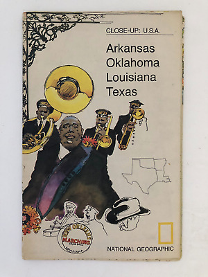
$5.49 Shipping Location: Georgetown, United States Template By Froo! National Geographic Map- 1974 Close-Up USA Oklahoma Texas Louisiana Arkansas National Geographic Map- 1974 Close-Up USA Oklahoma Texas ... moreLouisiana Arkansas Vintage 1974 two sided map Close-Up USA. Map shows Oklahoma, Louisiana, Arkansas, and Texas. The opposite side includes lots of historical information on the area by National Geographic Society. The map measures approx 35" x 23" in size. Never Unfolded. Shipping: All orders are carefully packaged. With a(Handle With Care Sticker) on the packaging. All orders ship the same or next business day. We ship orders Monday to Saturday. Orders placed before 2 pm(CST) on Fridays will ship on Saturday. We ship all orders via the United States Postal Service: First Class. Media Mail, Parcel Post, or Priority Mail, all include tracking numbers. Multi-Item Orders: We do combine shipping costs on multi-item orders. In order to receive the best shipping cost possible for your specific order please place your order. But before paying, request an invoice from us with combined shipping. We will return to you an adjusted invoice with the best shipping price for your order. Return Policy: Refunds given as money back or exchange(buyer’s choice) The buyer must pay return shipping. Please contact me within 14 days after receiving the item. Privacy Policy: Our company will never share your personal information in any way with an outside company. Our company will not send you unsolicited advertisements. Most reasonable offers are accepted. PayPal only. Please. Payment is expected within 2 days of auction end; immediate payment if you use Buy It Now. I will try and answer any questions. I am not an expert on anything I sell. And do my best to describe each item accurately. I buy many different items for the purpose of reselling them here on ebay. Any descriptions I give indicating the condition of item(s) such as: vintage. Antique, excellent, very good, good, and poor, or levels of functioning are purely subjective to what I observe, test and think of the item.
Free Shipping Location: Laconia, United States Approx 22 x 29 inch map of Casco Bay by mapmaker Ruth Lepper, 1985. Mailed in a hard tube, free shipping USA.
$25.00 Shipping Location: Perugia, Italy The first S.D.U.K. began appearing in 1829 when the society contracted John Walker to produce the first proofs. The initial production was completed in ... more1844 when the whole was issued in its first compiled atlas edition.
Buy It Now
$5.00 Shipping Location: Dunkirk, United States This is a vintage folding map of Montana, produced by the Official State Highway Commission in 1952. The map is an original piece and features the state's ... morehighways and roads, making it a valuable collectible for antique map enthusiasts. The map is of the United States of America and is specific to the state of Montana. This map is vintage. We try very hard to take photos of any imperfections, tears, or discoloration. Please see all pictures for details and contact us for any further information, thank you.
Free Shipping Location: Schertz, United States This antique plat atlas map, printed in 1873 by G.M. Hopkins & Co. showcases the areas of MILLERS & CHARLES RIVER - BOSTON & LOWELL RAILROAD YARD - FIRST ... more& BRIDGE Streets in Cambridge, Massachusetts. Perfect for genealogy and family history research, this map is over 150 years old and provides a glimpse into the past. Please note that the cover and title page are not included, they are only for reference. In addition, free shipping is available for customers in the USA, while calculated shipping is available for those outside the country. Explore the landowners and county of Middlesex County, as depicted on the map. Don't miss out on this unique opportunity to own a piece of history.
Buy It Now
Free Shipping Location: Dayton, United States Map is in Very Good Condition! Any Browning Is Enhanced By My Phone!
Buy It Now
$7.75 Shipping Location: Montrose, United States Date: 1852. Publisher: S. Augustus Mitchell. Original Antique Map-Map of the Middle States and part of the Southern. shows railways, canals etc. lots ... moreof interesting details.

$25.00 Shipping Location: Perugia, Italy Click Here. Double your traffic. Get Vendio Gallery- Now FREE! Lake Erie Maps& Prints An Authentic Antique Map: Not a Modern Reproduction! No Additional ... moreShipping Fees on Multiple Maps Shipped with the Largest Free Shipping on 5 or More Maps and Prints Description: It is an authentic Antique Map approximately 175 years old with original hand coloring as issued. It is from Chambers's Atlas for the People. Published in Edinburgh by W. R. Chambers, c. 1840. A copy of the title page is included. The map is not mounted, matted nor framed being sold as a single sheet as seen in the first pic. The map clearly shows an Independent Texas Republic as it existed around 1840, alsow showing New California amnd Russia Alaska. Overall. A Beautiful Map with Superb Color! Size: The map image measures approximately 8 by 10 inches(21x26cm) on a 9 1/4 by 11 1/2" page(24x30cm) with a margin all around as seen in the pic. Condition: It is in Very Good condition with overall tonal ageing. Basically as seen in the pics, blank on the reverse, printed on heavy paper with original hand coloring as issued. There is some very light handling around the edges and minor browning, nothing distracting, otherwise it is very clean in general with a nice antique quality that would frame up well, see the pics for more on condition. The pics are of the actual map. Payment Details: We accept most major credit cards through Paypal and Ebay. Please ask if you have any questions about payment. International and New Bidders are welcomed and encouraged. Payment is expected within 7 days. After which Nonpaying Bidders will be reported to Ebay to recoup our listing fees. Shipping: $ 3.50 for First Class or $4.95 for Priority Mail with Delivery Confirmation in the USA; $4.95 for First Class International to Canada; $8 for International Airmail elsewhere in the World. We ship daily. So if still bidding send us a quick email to hold or better just pay all at once at the end. USPS Express Mail is also available upon request, the actual rate will depen
Buy It Now
$13.69 Shipping Location: MANCHESTER, United Kingdom This beautiful map is from The Imperial Atlas of Modern Geography by W.G. Blackie, published by Blackie and Son, London, 1860.
Buy It Now
$7.49 Shipping Location: Colonia, United States Inc., Chicago U.S.A." along lower edge of map. The text on the verso in German is an illustrated travel guide.
|
|
|
In
|
Garmin Edge 800 cycling GPS computer with cadence/speed sensor w/USA map
Garmin Edge 800 with Speed/Cadence sensor Excellent condition. New set of bands and mount for bicycle stem Also included USA map Ready to roll. Ask before you bid! Unit dimensions. WxHxD: 2.0" x 3.7" x 1.0" 5.1 x 9.3 x 2.5 cm) Display size. WxH: 1.4" x 2.2" 3.6 x 5.5 cm) 2.6" diag(6.6 cm) Display resolution. WxH: 160 x 240 pixels. Touchscreen, Touchscreen: yes, Weight: 3.5 oz(98.0 g) Battery: rechargeable lithium-ion, Battery life: 15 hours. Typical, Water resistant: yes(IPX7) GPS-enabled: yes, High-sensitivity receiver: yes, Basemap: yes, Ability to add maps: yes, Accepts data cards: microSD™ card(some versions include a City Navigator microSD card) History: up to 180 hours, Waypoints/favorites/locations: 200, Routes: Limited by memory space available, Heart rate monitor: yes(some versions) Bike speed/cadence ... moresensor: yes(some versions) Foot pod: no, Automatic sync(automatically transfers data to your computer) no, Garmin Connect™ compatible(online community where you analyze. Categorize and share data) yes, Virtual Partner®(train against a digital person) no, Virtual Racer™(compete against other activities) no, Courses(compete against previous activities) yes, Auto Pause®(pauses and resumes timer based on speed) yes, Auto Lap®(automatically starts a new lap) yes, Auto Scroll(cycles through data pages during workout) yes, Multi-sport(changes sport mode with a press of a button) no, Advanced workouts(create custom. Goal-oriented workouts) yes, Pace alert(triggers alarm if you vary from preset pace) yes, Time/distance alert(triggers alarm when you reach goal) yes, Vibration alert: choose between alert tones and/or vibration alert) no, Interval training(set up exercise and rest intervals) yes, Heart rate-based calorie computation: yes, Swim metrics(stroke type. Stroke count and pool lengths) no, Training Effect(measures impact of an activity on your aerobic fitness) no, Customizable screen(s) yes, Barometric altimeter: yes, Unit-
|
|
|
Navionics Gold 1 All USA Bahamas Map Card MSD/1XG
Powered by Frooition Pro Holiday Returns. Any item purchased between 11/15/2012 and 1/15/2013 can be returned until 01/31/2013. Click to close full size. Item Description. Navionics Gold 1 All USA Bahamas Map Card MSD/1XG Model Number: 1XG Brand New in Original Packaging In Stock and Ready to Ship! Save Money Buying from Us! $ 199.00 Marine Gold All-in-One 2D charts including USA and N. Bahamas and all features for serious fishing and cruising. Features: Manufacturer's Part Number: 1XG Item Weight: 0.25 lb(s) Dimensions: 5.00 x 1.00 x 6.00 Item UPC: 821245565440 Payment Method Immediate payment is required upon selecting"Buy It Now" or upon checking out through the cart. We only accept payment via PayPal. If you purchase multiple items from us. Please email us before you pay so we can send you a combined invoice. Thanks for ... moreyour purchase! Sales Tax We are legally required to collect sales tax in the state of Illinois. The applicable amount of sales tax charged to an order will be calculated based on the shipment destination's state and Illinois sales tax laws. Domestic Shipping 1-Day Handling Time This item is in stock and we ship within 1 business day of payment. We will send you a confirmation email when your order ships as well as tracking information to your PayPal email address. FREE Standard Shipping Free Ground Shipping(UPS Ground. USPS First Class, or USPS Priority) has a transit time of 2- 5 business days. Free shipping is not available to Alaska or Hawaii. Combined Shipping We do combine shipping; please email us before you pay(we cannot send a combined shipping invoice after you pay) and we will send you an invoice. Combined shipping is generally 100% of the most expensive shipping charge and then a reduced charged(approximately 50% for each additional item. SAME DAY Expedited Shipping Order before 1 PM Central Time on a business day. And we will ship your order the same day via UPS 2nd Day Air(2 business days in transit) or UPS Next Day Air Saver(1 business day in transit) Expedited
|
|
|
USA SATELLITE COLOR IMAGE MAP - NATIONAL ATLAS from USGS - 1 MAP - DATED 1990
USA SATELLITE IMAGE MAP- from the U.S. Geological Survey- this is an original map. Not a copy: This color National Atlas Sheet was mosaiced from 16 NOAA-8 and 9 satellite images. It has the same image on both sides of the paper at the same scale covering the same exact area- it covers the 48 state area, no data was available for Alaska and Hawaii- it was printed in 1990- no image is shown of Canada or Mexico, or the Caribbean- on the reverse side image 24 areas are blocked in, numbered, and explained in text- the paper measures 19 inches high by 28 inches wide- this map is in very good condition, with slight wear. THIS MAP WILL BE SHIPPED FOLDED. Email any questions. THANKS for looking and bidding!
|
|
|
USA MAP by Aaron Foster Wall Art - Mounted - 18" X 24"
Hi! This is very nice piece of Wall Art- USA MAP- by Aaron Foster. It is not a poster- but a wooden piece. 18" X 24" X 1 1/2" Wide. It will stand on a tabletop/ desk. Or has 2 types of hangers on the back. A couple of small nicks for character- this pre-owned piece is a beautiful piece of decor. As well as educational. Add it to any room in your home! Fun way to keep up with your travels or to learn the states. Thank you for shopping! Good Luck!
|
|
|
USA Raised Relief Map~vintage Aero Service 28 x 18~50 states
Vintage True Raised Relief Map of The United States of America. 50 states. Measures 28" x 18" Made be Aero Service Corporation. Philadelphia 20, PA. Pull out index. Excellent condition just needs a delicate cleaning. Some stains on edge however can be cleaned off.
|
|
|
Garmin MapSource USA Topo Map DVD * 100k scale works w/ windows XP, Vista & 7
Garmin MapSource United States Topo 2008 DVD comparable to 1:100.000 scale USGS maps version issued just before the name changed to 100K. The Earth does not change much in a couple years so these maps are still very usefull works with windows XP. Vista and 7 No unlock code required. Install as many times as you want. Excellent Condition Auction includes: DVD*Michigan buyers pay 6% sales tax* Get More Detail Outdoor enthusiasts: we've mapped every hill and valley for your next great adventure. Now with more detail than ever. TOPO U.S. covers the finer points of the outdoors, with topographic maps comparable to 1:100,000 scale USGS maps. TOPO U.S. includes terrain contours, topo elevations, summits, parks, coastlines, rivers, lakes and geographical points. TOPO maps are ideal for hiking, hunting, camping, cycling and communing with nature. ... moreCoverage includes topographic detail of the entire United States, including Alaska, Hawaii and Puerto Rico. I do ship items the day after the auction ends at the very latest. No unlock code required. Install as many times as you want. Ships the same day or the day after the auction ends at the very latest. USA buyers only. All sales final
|
|
|
1748 Antique Map of Northeast USA - Handcolored engraving - Robert de Vaugondy
Great Deal! ~ half the appraised value ~ Must Sell ~ 1748 Antique Map of Northeast USA- Handcolored engraving- Robert de Vaugondy
|
|
|
Antique Colour Map of USA State of WEST VIRGINIA color map 1888
ANTIQUE MAP WEST VIRGINIA SMALL INSET BOTTOM RIGHT IS OF THE PANHANDLE or Northern Part of W. Virginia SIZE: 10.5 by 8 inches From Encyclopedia Britannica 9th edition dated 1888 VERY GOOD CONDITION THANKS FOR LOOKING Powered by The free listing tool. List your items fast and easy and manage your active items.
|
|
|
Antique Colour Map of USA State of VERMONT color map 1888
ANTIQUE MAP of VERMONT SIZE: 10.5 by 8 inches From Encyclopedia Britannica 9th edition dated 1888 VERY GOOD CONDITION THANKS FOR LOOKING Powered by The free listing tool. List your items fast and easy and manage your active items.
|
|
|
Antique Colour Map of USA State of VIRGINIA color map 1888
ANTIQUE MAP of VIRGINIA SMALL INSET TOP RIGHT IS OF THE SOUTH WESTERN CONTINUATION OF VIRGINIA SIZE: 10.5 by 8 inches From Encyclopedia Britannica 9th edition dated 1888 VERY GOOD CONDITION THANKS FOR LOOKING Powered by The free listing tool. List your items fast and easy and manage your active items.
|
|
|
Antique Colour Map of USA States of UTAH & ARIZONA color map 1888
ANTIQUE MAP UTAH& ARIZONA SIZE: 15.5 BY 10.5 inches From Encyclopedia Britannica 9th edition dated 1888 VERY GOOD CONDITION FOLD DOWN CENTRE THANKS FOR LOOKING Powered by The free listing tool. List your items fast and easy and manage your active items. f`565.RcmdId ViewItemDescV4,RlogId p4%60bo7%60jtb9%3Fum.rp73%28%3E%3Ff%60565-13cd6093653-0x104-
|
|
|
Antique Colour Map of USA State of WISCONSIN color map 1888
ANTIQUE MAP of WISCONSIN SMALL INSET TOP RIGHT IS GENERAL GEOLOGICAL MAP OF WISCONSIN SIZE: 10.5 by 8 inches From Encyclopedia Britannica 9th edition dated 1888 VERY GOOD CONDITION THANKS FOR LOOKING Powered by The free listing tool. List your items fast and easy and manage your active items.
|
|
|
ORIGINAL 29x18 Civil War MAP 1863 Boundary USA Union Confederate States
Ebay seller"pkgeneralstore" watermarked. Check out my! Atlas To Accompany The Official Records of the Union and Confederate Armies 1861-1865 series. IF THERE ARE ANY SPECIFIC ONES FROM THIS SERIES YOU ARE LOOKING FOR PLEASE EMAIL ME YOUR LIST! This was originally in a bound book like mostly were made and for 118 years old is in good condition with minor binding paper on back. Please look above at the photos to get an idea on specific areas& details this may have. Each map has a different range of cities& towns. States, water areas, possible railroad lines,possible troop stuff, landmarks& historical info! Roughly 29x18 in size. If you need more info as to this specific map please ask. IN THIS AUCTION: ORIGINAL 29x18 Civil War MAP 1863 Boundary USA Union Confederate States. There is a 1" tear by the bottom right of ... morethe fold about 2" to the right of it. Plate#167. Please take a closer look at the pictures as there is a lot of historical info here plus it looks nice. USA packing& postage is $11.95 shipped rolled in a thick heavy duty 24" tube. Win more than 1. Pay only one postage. International packing& priority postage is $55.00 Funds are expected to be received to me no later than 3 days after auction ends& we invoice you thanks. s please ask AUCTION TERMS: All International bidders please email me before bidding so i can exempt& approve you to be able to bid in my auctions as per my terms. We ship worldwide to approved bidders! INTERNATIONAL POSTAGE& PACKING COSTS ARE BASED ON VALUES BEING SENT DUE TO SIZE& WEIGHT OF THE BOX& THE NEW USA POST OFFICE RATES. IF YOU HAVE A QUESTION ON POST OFFICE COSTS PLEASE EMAIL ME. PAYMENTS ARE DUE NO LATER THAN 3 DAYS AFTER AUCTION ENDS& INVOICES SENT. 1) International packing& priority postage is $55.00 WE WILL SEND INVOICES OUT ONCE ALL TISSUE AUCTIONS ARE DONE SO PLEASE WAIT TO PAY. THIS IS DONE IN CASE YOU BID& WIN MORE THAN 1 ITEM AND SO THAT THE POSTAGE COSTS REFLECT THE ABOVE POSTED RATES NEEDED
|
|
|
1846 USA REPUBLIC OF TEXAS, ORIGINAL FLEMMING MAP
Vereinigte Staaten von Nord-America Carl Flemming. 1846 Original hand colored map from Sohr's Hand-Atlas published 1846 in Glogau. Carl Flemming was the founder of an very important German firm located in Glogau. The Germans were very interested in America at this period. During the time from 1836-1845, over 10,000 Germans emigrated to Texas. The map includes excellent topographical details, various European colonies, many Indian tribestowns, forts, rivers, mountains,forts, missions. Original handcoloured. Some stains(please see the pictures) otherwise good condition. Size: 17.3X14.3" 44.3X36.5 cm)
|
|
|
1812 LARGE HISTORICAL MAP GREAT LAKES CANADA USA
History-Image Photo. Map& Poster Archive Search in titles& descriptions Browse Photographs by Category Historic Posters Historic Maps Shipping& Payment We combine shipping so you only pay one shipping charge regardless of how many items you purchase U.S. $ 5.95 Canada& Mexico $ 7.50 International $ 10.00 You will receive an email at the close of auction. Click on the payment link to complete payment. We accept all forms of auction payments that are allowed by ebay. You can also pay for your purchase over the phone with a credit card: 503) 408-2360 See our Framing work work Who are you buying from? This is a large and extraordinarily detailed map of the Great lakes region of Canada and present-day United States. Title and description on map: To the officers of the Army and the citizens of the United States this map of Upper ... moreand Lower Canada and United States. Contigious(sic) Contracted from the manuscript surveys of P.F. Tardieu. Is respectfully inscribed by the public's most obedient servant Thomas Kensett. Copyright secured and entered. November 4th, 1812. Kensett sculp. Cheshire, Conn. Actual map is much sharper and detailed than the low resolution scanned image used here. Map measures approximately 24" by 30" 61cm by 76cm) The map is a modern reprint. It is reprinted(a modern reprint) using premium semi-matte. Japanese paper and Ultrachrome ink, which has an archival rating of 125+ years. For more information about how the maps are made see our Custom Framing& Matting Options We offer a variety of sizes and options for framing your purchase. to see frames and prices Example of map detail: Frequently Asked Questions Is the resolution disappointing? No. Is the simple answer. Because we are dealing with historical pieces from a wide range of regions, creators and time periods, there is variation in the quality. However, we always ask ourselves if we would be pleased with a particular image framed and on display before we add it to our inventory. We do not carry low-quality"s
|
|
|
RARE Vintage 1937 Romance Pictorial Map of the Hudson River Valley NY USA
Vintage Map* This is a lovely rare pictorial map! Romance Map of the Hudson River Valley Copyright 1937 by Marguerite Hess Parrish Randy McNally& Co. Chicago, Publishers Josephine Wilhelm Wickser. ~Consultant~ The map looks to have been professionally framed. I have not opened the back but the Map appears to be in Pristine condition. It is framed in a nice wood frame. There is 2 places on the frame that have some scuffing. Please see picture. The map also features information that pertains to the map. Located on each side. In the frame it measures 21 1/2" X 26 1/2" This is a Great Displayable Collectible piece! Please see all pictures for a better description. ~Email with any questions. Thank You! PayPal Only. International buyers please email for shipping cost. Please make your payment within 3 days after auction ends. I will ... moreship your item within 3 business days. Please email with any issues you may have prior to leaving feedback. I strive to make happy customers and will try to resolve any issues. Thanks! Posted with the
|
|
|
Mexico City plan c.1905 original antique USA map color lithographed
Mexico City plan c.1905 original antique USA map color lithographed Mexico Issued c.1905. Leipzig by Wagner& Debes. Fine original antique color lithographed plan of this American city. Printed on quality paper which retains its inherent structural flexibility and soundness. In VG or better condition. Overall very clean[note: we grade very conservatively and always seek to disclose any noteworthy flaws] The printed area remains pleasing. A nice impression that would look great framed. Sheet measures c. 6 1/8" H x 8 1/8" W. Engraved area measures c. 5 3/4" H x 7 3/4" W. Original fold line as issued. 28999] Any defects along the sheet edges and in the margins may be seen in the photos. note: All old sheets of printed paper possibly have short edge splits. Each sheet has existed for a very long time and has probably been ... morehandled repeatedly in the course of it's existence. It has a history unique to it as an object. Most of the time any edge splits are short. Minor, insignificant and have been closed- either long ago or more recently with small pieces of archival tape. Most often these splits are trivial and easy to overlook visually. Basically, they would not significantly affect the piece adversely. The item is offered as seen. Please look carefully and make your decision knowing this antique image is nice. But it is not in perfect"like new" condition. However, with whatever flaws it possesses, it remains entirely worthy of ownership and inclusion in any related collection. We feel it will prove very pleasing to its new owner. We stand behind everything we sell. Everything we offer is guaranteed to be an authentic original antique item as described. We do not sell modern reproductions. Please visit our. We happily accept PayPal! WE OFFER FLAT RATE SHIPPING WORLD WIDE! Please request an invoice before paying for multiple items so that we can ensure that you are not overcharged for shipping! To receive our fla
|
|
|
1895 NEWARK NEW JERSEY Essex County NJ USA MAP CD
DESCRIPTION NEWARK. NEW JERSEY PANORAMIC MAP ON CD-ROM ~ DESCRIPTION ~ 1895 NEWARK NEW JERSEY Essex County NJ USA MAP CD Ultra-high resolution panoramic map on CD-ROM JPEG. MrSid or JPEG2000 File Formats Map viewing software included No restrictions on use Looking for a printed copy of this map? Please contact us at. ~ SAMPLE IMAGE QUALITY ~ The images below are SAMPLE IMAGES to showcase quality only. The map specific to this auction is shown at the top of the page. 25% ZOOM 50% ZOOM 75% ZOOM 100% ZOOM Powered by The free listing tool. List your items fast and easy and manage your active items.
|
|
|
1894 LOS ANGELES CALIFORNIA LA CA USA MAP CD
DESCRIPTION LOS ANGELES. CALIFORNIA PANORAMIC MAP ON CD-ROM ~ DESCRIPTION ~ 1894 LOS ANGELES CALIFORNIA LA CA USA MAP CD Ultra-high resolution panoramic map on CD-ROM JPEG. MrSid or JPEG2000 File Formats Map viewing software included No restrictions on use Looking for a printed copy of this map? Please contact us at. ~ SAMPLE IMAGE QUALITY ~ The images below are SAMPLE IMAGES to showcase quality only. The map specific to this auction is shown at the top of the page. 25% ZOOM 50% ZOOM 75% ZOOM 100% ZOOM Powered by The free listing tool. List your items fast and easy and manage your active items.
|
|
|
1872 COLUMBIA SOUTH CAROLINA SC USA MAP CD
DESCRIPTION COLUMBIA. SOUTH CAROLINA PANORAMIC MAP ON CD-ROM ~ DESCRIPTION ~ 1872 COLUMBIA SOUTH CAROLINA SC USA MAP CD Ultra-high resolution panoramic map on CD-ROM JPEG. MrSid or JPEG2000 File Formats Map viewing software included No restrictions on use Looking for a printed copy of this map? Please contact us at. ~ SAMPLE IMAGE QUALITY ~ The images below are SAMPLE IMAGES to showcase quality only. The map specific to this auction is shown at the top of the page. 25% ZOOM 50% ZOOM 75% ZOOM 100% ZOOM Powered by The free listing tool. List your items fast and easy and manage your active items.
|
|
|
1885 BROOKLYN BRIDGE NEW YORK USA MAP CD
DESCRIPTION BROOKLYN BRIDGE. NEW YORK PANORAMIC MAP ON CD-ROM ~ DESCRIPTION ~ 1885 BROOKLYN BRIDGE NEW YORK USA MAP CD Ultra-high resolution panoramic map on CD-ROM JPEG. MrSid or JPEG2000 File Formats Map viewing software included No restrictions on use Looking for a printed copy of this map? Please contact us at. ~ SAMPLE IMAGE QUALITY ~ The images below are SAMPLE IMAGES to showcase quality only. The map specific to this auction is shown at the top of the page. 25% ZOOM 50% ZOOM 75% ZOOM 100% ZOOM Powered by The free listing tool. List your items fast and easy and manage your active items.
|
|
|
1889 CATSKILL NEW YORK Greene County NY USA MAP CD
DESCRIPTION CATSKILL. NEW YORK PANORAMIC MAP ON CD-ROM ~ DESCRIPTION ~ 1889 CATSKILL NEW YORK Greene County NY USA MAP CD Ultra-high resolution panoramic map on CD-ROM JPEG. MrSid or JPEG2000 File Formats Map viewing software included No restrictions on use Looking for a printed copy of this map? Please contact us at. ~ SAMPLE IMAGE QUALITY ~ The images below are SAMPLE IMAGES to showcase quality only. The map specific to this auction is shown at the top of the page. 25% ZOOM 50% ZOOM 75% ZOOM 100% ZOOM Powered by The free listing tool. List your items fast and easy and manage your active items.
|
|
|
1892 DERUYTER NEW YORK Madison County NY USA MAP CD
DESCRIPTION DERUYTER. NEW YORK PANORAMIC MAP ON CD-ROM ~ DESCRIPTION ~ 1892 DERUYTER NEW YORK Madison County NY USA MAP CD Ultra-high resolution panoramic map on CD-ROM JPEG. MrSid or JPEG2000 File Formats Map viewing software included No restrictions on use Looking for a printed copy of this map? Please contact us at. ~ SAMPLE IMAGE QUALITY ~ The images below are SAMPLE IMAGES to showcase quality only. The map specific to this auction is shown at the top of the page. 25% ZOOM 50% ZOOM 75% ZOOM 100% ZOOM Powered by The free listing tool. List your items fast and easy and manage your active items.
|
|
|
Pre1959 Pictorial Map of the USA published by the US Information Service, London
Pre- 1959 Pictorial Map of the USA published by the US Information Service. London with dated envelope Folded map measuring 32" x 24" Copyright General Drafting Co Inc. Convent Station, New Jersey, USA. Printed by Bradley Simpkins Ltd for Design and Production Ltd, Frederick Mews, London, England The map is illustrated with small pictures depicting the history. Agriculture and industry of the then 48 states- it lists Alaska as a territory not a state(Alaska became a state in 1959) The map is heavily folded(see photo) and comes complete with the original dated envelope from the US Information Service at the American Embassy. London- envelope dated 18 December 1959. There is some wear to the edges and a minor tear along one of the folds, buy is in very good condition for a map over 50 years old. A great piece of Americana. Postage ... morewithin the UK: GBP£1.50 for Ordinary mail, at your risk. GBP£2.50 for Recorded Delivery. GBP£6.00 for Special Delivery. Airmail Postage to Europe: GBP£3.00 for Ordinary Airmail, at your risk. GBP£8.00 for International Signed For Airmail. Airmail Postage outside the EU: GBP£4.00 for Ordinary Airmail, at your risk. GBP£9.00 for International Signed For Airmail
|
|
|
USA FLORIDA SAVANNAH GEORGIA CAROLINA NORTH AMERICA ENGR. MAP BELLIN 1750 #A994
1* Original and Decorative coloured copper engraving map by Jaques-Nicolas Bellin. Printed about 1750 AD Map of the East Coast- USA"Carte Des Costes De La Floride Francoise. Cartographer: Jaques-Nicolas Bellin(1703- 21st March 1772) was a hydrographer and geographer as well as chief cartographer of the French Navy. Description: We offer a beautiful coloured copper engraving map by Jaques-Nicolas Bellin. The map shows the East Coast of the USA with the federal states of Florida. Georgia and South Carolina. On the map recorded the cities of Charleston and Savannah! Size: Leaf app. 18.5 x 25,4 cm Map app. 14.3 x 20,6 cm Condition: very good condition strong print and nice colour marginal stained Please have a look at the pictures! We offer You only originals and no reproduction! Original und Dekorative kolorierte Kupferstich Karte von Jaques-Nicolas ... moreBellin. Gedruckt um 1750 AD Karte von der Ostküste- USA"Carte Des Costes De La Floride Francoise. Kartograph: Jaques-Nicolas Bellin(1703- 21. März 1772) war ein französischer Hydrograph und Geograph sowie Oberster Marineingenieur und-geograph. Beschreibung: Wir bieten Ihnen eine kolorierte Kupferstich Karte von Jaques-Nicolas Bellin an. Die Karte zeigt die Ostküste der USA mit den Bundesstaaten von Florida. Georgia und South Carolina. Auf der Karte sind die Städte Charleston und Savannah verzeichnet! Maße: Blatt ca. 18.5 x 25,4 cm Karte ca. 14.3 x 20,6 cm Zustand: sehr guter Zustand kräftiger Druck und schönes Kolorit geringfügig fleckig Sehen Sie sich die Bilder an! Wir bieten Ihnen nur Originale an und keine Reproduktion! Für eine weitere Auswahl. Besuchen Sie und in unseren beiden Ebay Shops: For another selection. Visit us at our two Ebay Stores: Powered by The free listing tool. List your items fast and easy and manage your active items.
|
|
|
NORTH & SOUTH AMERICA CANADA USA CARIBBEAN BRAZIL ENGR. MAP HOMANN 1716 #A915S
1* Take advantage of the offer of rare prints and books as a crisis-resistant and stable value investment at reasonable prices! Nutzen Sie das Angebot von seltenen Graphiken und Büchern als krisenbeständige und stabile Wertanlage zu vernünftigen Preisen! Decorative and large-size old-coloured copper engraving map. Published by Johann Baptist Homann, out of the Atlas: Grosser Atlas Uber die Gantze Welt. Wie diese sowol Nach Göttlicher Allweisen Schöpffung aus den heutigen Grund-Sätzen. zu betrachten" printed Nuremberg, 1716 AD Map of the continents North& South America"Totius Americae. Cartographer: Johann Baptist Homann( 20 March 1664 in Oberkammlach near Kammlach. Bavaria; 1 July 1724 in Nuremberg, was a geographer and cartographer, who made atlases and maps. Description We offer a Original and ... moreold-coloured copper engraving map by J. B. Homann. This splendid copper engraving map shows the both continents of North- and South America with all countries from Canada. USA, Mexico, the Caribbean, Venezuela, Peru, Brazil, Chile and Argentina. The map is decorated with a beautiful title cartouche. The map is a wonderful collection item! Size: Leaf app. 59.4 x 52,2 cm Map app. 58.0 x 49,2 cm Condition: good condition strong print& beautiful old colour slightly brownish and stained the center fold is complete restored some restored tears at the bottom margin Please have a look at the pictures! We offer only Originals. No Reproductions! Dekorative und Großformatige altkolorierte Kupferstichkarte. Herausgegeben von Johann Baptist Homann aus dem Atlas: Grosser Atlas Uber die Gantze Welt. Wie diese sowol Nach Göttlicher Allweisen Schöpffung aus den heutigen Grund-Sätzen. zu betrachten" gedruckt in Nürnberg, 1716 AD Karte von den Kontinenten Nord- und Südamerika"Totius Americae. Kartograph: Johann Baptist Homann( 20. März 1664 in Oberkammlach. Heute Teil von Kammlach im Landkreis Unterallgäu;
|
|
|
USA WEST COAST LOS ANGELES - Anitque Map 1909
USA West Coast- Antique Map 1909 This is a genuine antique lithographic print. Carefully taken out of an old german encylopedia. Over 100 years old. 100% original from Meyers Konversations-Lexikon 6. Edition- Leipzig/ Germany. No reprint! Size: 9.7" x 12" 25 x 31 cm) Blank verso. Centerfold as issued. Little yellowed due to age. Shipment without passe-partout. FLAT CHARGE only US $ 5.99- Worldwide Shipment from Europe with PRIORITY MAIL FLAT CHARGE includes PRIORITY MAIL POSTAGE. Professional packaging with board backed envelopes and inlying POLY ZIP BAGS. Waterproof zip seal to protect your map against damages due to damp. I PROMISE DISPATCH WITHIN 24 HOURS. Satisfaction always garanteed Powered by The free listing tool. List your items fast and easy and manage your active items.
|
|
|
1883 LETTS - map of United States America north east sheet, Mexico, Georgia, USA
Descrizione/ Description/ Beschreibung/ Descripciòn/ Descripción_ ATTENZIONE: TRATTASI DI INCISIONE MOLTO RARA E PARTICOLARE. DIFFICILE DA TROVARE SUL MERCATO PER LA SUA RARITA' PREZIOSITA, GRANDEZZA E SOPRATTUTTO PER LA SUA ROBUSTEZZA NELLA CARTA INCISA E NELLA SUA COLORAZIONE ANCORA MOLTO NITIDA E VIVA. LUCENTE, PRIVA DI INBRUNITURE. PRIVA DI MACCHIE E NON COMUNE COME TUTTE LE ALTRE CHE MAGARI SI TROVANO. GRAZIE MOLTISSIMO DELL'ATTENZIONE! antiqua.trinacria_ 1883. United States of America north east sheet: Mexico. Georgia, USA. In vendita un' Elegante. Originale e molto Particolare Mappa Geografica di" LETTS" con un'ottima inchiostratura originale. Carta molto forte e robusta ed in generale una Mappa Geografica veramente molto grande. Ben collocata e dettagliata in ogni punto. Mappa ottima. Elegante perfetta ... moreed originale da collezione. AUTORE/ INCISORE: LETTS. EPOCA: EDIZIONE& STAMPA DEL. 1883. TECNICA: INCISIONE SU ACCIAIO. MISURE: FORMATO DEL FOGLIO DOPPIO: Cm 45.0 x 37,0/ Inch 18.0" x 15.0 Approx. CONDIZIONI: EDIZIONE RARA E PARTICOLARE- OTTIMA SUI DETTAGLI GEOGRAFICI; OTTIMA LA COLORAZIONE UTILIZZATA PER DIFFERENZIARE I VARI TERRITORI E REGNI; CARTA ABBASTANZA FORTE. PULITA, E BEN STILIZZATA. PICCOLISSIME ED INNOCUE TRACCE DI USURA DEL TEMPO. COME DA FOTO; MAPPA MOLTO FINE. BEN DISEGNATA E STORICAMENTE DETTAGLIATA SU OGNI PUNTO; CARATTERISTICHE: MAPPA GEOGRAFICA TRATTA DA UN'EDIZIONE INGLESE- UK; LA PRESENTE MAPPA CONTIENE LA DESCRIZIONE STORICA DI UN PRECISO CONTESTO STORICO. ED E' INCISA E DISEGNATA ADOTTANDO UNA TECNICA VERAMENTE OTTIMA. ORIGINALE E MOLTO ELEGANTE. L'INCHIOSTRATURA E LA COLORAZIONE UTILIZZATA SI PRESENTA MOLTO VIVA. FORTE, PERFETTA E VERAMENTE OTTIMA. TRATTASI DI UNA ORIGINALE MAPPA STORICA DIFFICILE DA REPERIRE SUL MERCATO; NOTE: TRATTASI DI INCISIONE GEOGRAFICA SU ACCIAIO ORIGINALE! NON VENDIAMO ASSOLUTAMENTE RIPRODUZIONI!
|
|
|
NORTH AMERICA (USA, CANADA, & MEXICO) MAP 1820 MOTP
This is an exquisite full-color Reproduction printed on heavyweight(7.0 MIL) Glossy Photo Paper. These maps are perfect for framing. Or a wonderful and unique gift for family members, friends or co-workers! All Information is Carefully Compiled from Actual Surveys Original Maps are often difficult to find and usually have fold lines. Identifying stamps or markings, tears, ragged edges, and assorted other natural signs of age that detract from their beauty. All of our maps have been professionally restored to depict their original beauty, while keeping all historical data intact. These maps are fabulous pieces of history full of information useful to Historians. Genealogists, Cartographers, Relic Hunters, Others. They make fascinating conversation pieces and splendid works of art for the home or office. Map Size: 23 x 28.5 Site Specifics To ... moreThis Map Are: This is a beautiful restored map of the Americas. It includes Canada. Spanish Mexico, Russian Possessions, British Occupation of Washington, Oregon, and Idaho. This map also shows the Missouri Territory, the Michigan Territory, East, and Southern States at this time. The following towns are featured: Many cities throughout the three countries This Map is Situated in: North America(United States. Canada, and Mexico) SKU: ITNA0002 and Powered By:
|
|
|
Epiphone USA United States Map Worn Brown Chrome Hardware Electric Guitar
Willcutt Guitar Shoppe has been in business since 1968 here in Lexington. Kentucky. Owned by Bob Willcutt; a Master Luthier and Author, we offer a huge selection of guitars, amplifiers and accessories. Buying from us assures you quality products, professional setup, fast shipping and friendly service. Please feel free to call us with any questions! 859) 276-4070 Thanks for looking! Slightly scratched on the bottom of Florida. But otherwise in good condition. Mahogany body Maple neck Rosewood fretboard Humbucking pickups Stopbar tailpiece Tune-o-matic bridge Chrome hardware Sealed tuners with chrome buttons 24-3/4" scale 1-11/16" nut width*Free shipping to continental US addresses only* This guitar may be listed for sale on different sites simultaneously. If it sells elsewhere. The eBay listing will be ended*We can only ship to a ... morePayPal verified address. Which is the same as your billing address Please ask all questions prior to bidding Thanks! Please call(859) 276-4070 x3 for an in-hand description International buyers are responsible for all shipping cost. Local taxes, and import taxes. Contact your customs for details. We offer international shipping through UPS. FedEx, and USPS. Please feel free to send a message or call us to get the best possible rate!
|
|
|
USA: Organization of Territories, US since 1803: 1810, 1835 & 1855, 1956 map
The Organization of Territories in the United States since 1803: I. 1803-1810; II. 1810-1835; III. 1835-1855; IV. Since 1855 Colour vintage map. Scale 1: 30.000,000; Scale 1: 30,000,000; Scale 1: 30,000,000; Scale 1: 30,000,000, 1956 Title of map: The Organization of Territories in the United States since 1803: I. 1803-1810; II. 1810-1835; III. 1835-1855; IV. Since 1855' The image below shows an enlarged cross section from the centre of the map to show the level of printed detail. This map is folding hence the centrefold line may show on the image below: DATE PRINTED: 1956 IMAGE SIZE: Approx 23.5 x 32.0cm. 9.25 x 12.5 inches(Large) Please note that this is a folding map. ARTIST/CARTOGRAPHER/ENGRAVER: Unsigned PROVENANCE: Shepherd's Historical Atlas" By William R. Shepherd; Published by George Philip and Son Limited, London. 8th ... moreEdition. Please note that virtually all antique and vintage maps and prints have been extracted from books, atlases or newspapers. TYPE: Colour vintage map. Scale 1: 30.000,000; Scale 1: 30,000,000; Scale 1: 30,000,000; Scale 1: 30,000,000. This map was published in 1956 but it may depict an earlier representation of the area shown dated 1855 and the mapmaker may have drawn on an earlier original work VERSO: There are images and/or text printed on the reverse side of the picture. In some cases this may be visible on the picture itself(please check the scan prior to your purchase) or around the margin of the picture CONDITION: Good; suitable for framing. Please check the scan for any blemishes prior to making your purchase. Virtually all antiquarian maps and prints are subject to some normal aging due to use and time which is not obtrusive unless otherwise stated. I offer a no questions asked return policy- see below. AUTHENTICITY: This is an authentic historic print. Published at the date stated above. I do not offer reproductions. It is not a modern copy. The term'original' when applied to a print means that it was printed at the first or original date of publication;
|
|
|
USA: State Claims to Western Lands, 1783-1802, 1942 map
State Claims to Western Lands. 1783-1802 Colour vintage map. 1942 Title of map: State Claims to Western Lands. 1783-1802' The image below shows an enlarged cross section from the centre of the map to show the level of printed detail: DATE PRINTED: 1942 IMAGE SIZE: Approx 16.5 x 10.5cm. 6.5 x 4 inches(Small) ARTIST/CARTOGRAPHER/ENGRAVER: From Harper's Atlas of American History PROVENANCE: The Growth of the American Republic" By Samuel Eliot Morison and Henry Steele Commager; Published by Oxford University Press, London. Please note that virtually all antique and vintage maps and prints have been extracted from books, atlases or newspapers. TYPE: Colour vintage map. This map was published in 1942 but it may depict an earlier representation of the area shown dated 1802 and the mapmaker may have drawn on an earlier original work ... moreVERSO: There is nothing printed on the reverse side. Which is plain CONDITION: Good; suitable for framing. Please check the scan for any blemishes prior to making your purchase. Virtually all antiquarian maps and prints are subject to some normal aging due to use and time which is not obtrusive unless otherwise stated. I offer a no questions asked return policy- see below. AUTHENTICITY: This is an authentic historic print. Published at the date stated above. I do not offer reproductions. It is not a modern copy. The term'original' when applied to a print means that it was printed at the first or original date of publication; it does not imply that the item is unique. Print' means any image created by applying an inked block to paper or card under pressure by any method including wood engraving, steel engraving, copperplate, wood cut and lithography. REMARKS: FRANCE: Gravures et Cartes anciennes. DEUTSCHLAND: Alte Lankarten und Stadt ansichten. ITALIA: Stampe& Mappe antiche. ESPAÑA: Mapas antiquos y impresiones antiguas. E and OE. Force Majeure. English law shall apply. RETURNS POLICY: I offer a no questions returns policy. All I ask is that you pay return shi
|
|
|
USA: Standard Railway time,1907 map
Standard Railway time Antique map. 1907 Title of map: Standard Railway time' The image below shows an enlarged cross section from the centre of the map to show the level of printed detail: DATE PRINTED: 1907 IMAGE SIZE: Approx 13.0 x 20.5cm. 5 x 8 inches(Medium) ARTIST/CARTOGRAPHER/ENGRAVER: Unsigned PROVENANCE: The Americana" Editor-in-Chief Frederick Converse Beach. Managing Editor George Edwin Rines, Published by Scientific American Compiling Dep't, New York. Please note that virtually all antique and vintage maps and prints have been extracted from books, atlases or newspapers. TYPE: Antique map VERSO: There is nothing printed on the reverse side. Which is plain CONDITION: Good; suitable for framing. Please check the scan for any blemishes prior to making your purchase. Virtually all antiquarian maps and prints are subject ... moreto some normal aging due to use and time which is not obtrusive unless otherwise stated. I offer a no questions asked return policy- see below. AUTHENTICITY: This is an authentic historic print. Published at the date stated above. I do not offer reproductions. It is not a modern copy. The term'original' when applied to a print means that it was printed at the first or original date of publication; it does not imply that the item is unique. Print' means any image created by applying an inked block to paper or card under pressure by any method including wood engraving, steel engraving, copperplate, wood cut and lithography. REMARKS: FRANCE: Gravures et Cartes anciennes. DEUTSCHLAND: Alte Lankarten und Stadt ansichten. ITALIA: Stampe& Mappe antiche. ESPAÑA: Mapas antiquos y impresiones antiguas. E and OE. Force Majeure. English law shall apply. RETURNS POLICY: I offer a no questions returns policy. All I ask is that you pay return shipping and mail back to me in original condition. Suitably packed& insured, within 14 days of receipt.
|
|
|
USA: War 1862: 7 Days Battles before Richmond June 26-July 2, sketch map, 1942
The Seven Day's Battles before Richmond June 26th-July-2nd Vintage map. 1942 Title of map: The Seven Day's Battles before Richmond June 26th-July-2nd' The image below shows an enlarged cross section from the centre of the map to show the level of printed detail: DATE PRINTED: 1942 IMAGE SIZE: Approx 9.5 x 15.0cm. 3.75 x 5.75 inches(Small) ARTIST/CARTOGRAPHER/ENGRAVER: Prepared by S.E. Morison for the Oxford history of the United States PROVENANCE: The Growth of the American Republic" By Samuel Eliot Morison and Henry Steele Commager; Published by Oxford University Press, London. Please note that virtually all antique and vintage maps and prints have been extracted from books, atlases or newspapers. TYPE: Vintage map. This map was published in 1942 but it may depict an earlier representation of the area shown dated 1862 and ... morethe mapmaker may have drawn on an earlier original work VERSO: There is nothing printed on the reverse side. Which is plain CONDITION: Good; suitable for framing. Please check the scan for any blemishes prior to making your purchase. Virtually all antiquarian maps and prints are subject to some normal aging due to use and time which is not obtrusive unless otherwise stated. I offer a no questions asked return policy- see below. AUTHENTICITY: This is an authentic historic print. Published at the date stated above. I do not offer reproductions. It is not a modern copy. The term'original' when applied to a print means that it was printed at the first or original date of publication; it does not imply that the item is unique. Print' means any image created by applying an inked block to paper or card under pressure by any method including wood engraving, steel engraving, copperplate, wood cut and lithography. REMARKS: FRANCE: Gravures et Cartes anciennes. DEUTSCHLAND: Alte Lankarten und Stadt ansichten. ITALIA: Stampe& Mappe antiche. ESPAÑA: Mapas antiquos y impresiones antiguas. E and OE. Force Majeure. English law shall apply. RETURNS POLICY: I offer a no ques
|
|
|
CALIFORNIA MAP, USA, NORTH, YOSEMITE, ORIGINAL ANTIQUE 1903
An antique map titled: CALIFORNIA" Northern PArt Originally issued in: The New Volumes of the Encylopaedia Britannica- 10th Edition Publication date: 1903 Description: An attractive antique map of the northern part of the US state of California as it appeared in 1903. INCLUDES INSET MAPS OF SAN FRANCISCO& YOSEMITE VALLEY. This is an original map. Published over 109 years ago! This is not only a fascinating historical reference. Showing how the area has changed over the years, it is also a beautiful work of art. A beautiful map that would look fantastic framed either individually or in a group. Size: Map measures: c. 38cm x 27cm/ 15" x 10.5" Space for matting/ mounting Condition: Good. There are some slight age related marks. But these have minimal impact on the map. Being over two pages there is a natural fold in the paper(as ... moreseen) Back/ verso is clean and clear Click HERE to see more Views& Maps arranged by Country Payment: Accepted by PayPal Postage: to UK £3- Royal Mail 1st class, to anywhere in Europe. £5.00 by Air Mail, to the rest of the world, £6.50 by Airmail. Other postage services are available
|
|
|
ALABAMA MAP, USA, ORIGINAL ANTIQUE 1903
An antique map titled: ARKANSAS" Originally issued in: The New Volumes of the Encylopaedia Britannica- 10th Edition Publication date: 1903 Description: An attractive antique map of the US state of Arkansas as it appeared in 1903. This is an original map. Published over 109 years ago! This is not only a fascinating historical reference. Showing how the area has changed over the years, it is also a beautiful work of art. A beautiful map that would look fantastic framed either individually or in a group. Size: Map measures: c. 38cm x 27cm/ 15" x 10.5" Space for matting/ mounting Condition: Very Good. There are some slight age related marks. But these have minimal impact on the map. Being over two pages there is a natural fold in the paper(as seen) Back/ verso is clean and clear Click HERE to see more Views& Maps arranged by ... moreCountry Payment: Accepted by PayPal Postage: to UK £3- Royal Mail 1st class, to anywhere in Europe. £5.00 by Air Mail, to the rest of the world, £6.50 by Airmail. Other postage services are available
|
|
|
USA: Agriculture: Irrigation projects & Roster of Federal Dams, sketch map, 1942
Irrigation projects and Roster of Federal Dams. 1942 Vintage map. 1942 Title of map: Irrigation projects and Roster of Federal Dams. 1942' The image below shows an enlarged cross section from the centre of the map to show the level of printed detail: DATE PRINTED: 1942 IMAGE SIZE: Approx 11.5 x 17.5cm. 4.5 x 6.75 inches(Small) ARTIST/CARTOGRAPHER/ENGRAVER: Reproduced by permission of the New York Times PROVENANCE: The Growth of the American Republic" By Samuel Eliot Morison and Henry Steele Commager; Published by Oxford University Press, London. Please note that virtually all antique and vintage maps and prints have been extracted from books, atlases or newspapers. TYPE: Vintage map. This map was published in 1942 but it may depict an earlier representation of the area shown dated 1942 and the mapmaker may have drawn on an earlier ... moreoriginal work VERSO: There is nothing printed on the reverse side. Which is plain CONDITION: Good; suitable for framing. Please check the scan for any blemishes prior to making your purchase. Virtually all antiquarian maps and prints are subject to some normal aging due to use and time which is not obtrusive unless otherwise stated. I offer a no questions asked return policy- see below. AUTHENTICITY: This is an authentic historic print. Published at the date stated above. I do not offer reproductions. It is not a modern copy. The term'original' when applied to a print means that it was printed at the first or original date of publication; it does not imply that the item is unique. Print' means any image created by applying an inked block to paper or card under pressure by any method including wood engraving, steel engraving, copperplate, wood cut and lithography. REMARKS: FRANCE: Gravures et Cartes anciennes. DEUTSCHLAND: Alte Lankarten und Stadt ansichten. ITALIA: Stampe& Mappe antiche. ESPAÑA: Mapas antiquos y impresiones antiguas. E and OE. Force Majeure. English law shall apply. RETURNS POLICY: I offer a no questions returns policy. All I ask is that yo
|
|
|
USA: The War in 1862: The Eastern Theatre of War, 1942 map
The Eastern Theatre of War Colour vintage map. 1942 Title of map: The Eastern Theatre of War' The image below shows an enlarged cross section from the centre of the map to show the level of printed detail: DATE PRINTED: 1942 IMAGE SIZE: Approx 16.5 x 10.0cm. 6.5 x 4 inches(Small) ARTIST/CARTOGRAPHER/ENGRAVER: Prepared by S.E. Morison for the Oxford history of the United States PROVENANCE: The Growth of the American Republic" By Samuel Eliot Morison and Henry Steele Commager; Published by Oxford University Press, London. Please note that virtually all antique and vintage maps and prints have been extracted from books, atlases or newspapers. TYPE: Colour vintage map. This map was published in 1942 but it may depict an earlier representation of the area shown dated 1862 and the mapmaker may have drawn on an earlier original work VERSO: ... moreThere is nothing printed on the reverse side. Which is plain CONDITION: Good; suitable for framing. Please check the scan for any blemishes prior to making your purchase. Virtually all antiquarian maps and prints are subject to some normal aging due to use and time which is not obtrusive unless otherwise stated. I offer a no questions asked return policy- see below. AUTHENTICITY: This is an authentic historic print. Published at the date stated above. I do not offer reproductions. It is not a modern copy. The term'original' when applied to a print means that it was printed at the first or original date of publication; it does not imply that the item is unique. Print' means any image created by applying an inked block to paper or card under pressure by any method including wood engraving, steel engraving, copperplate, wood cut and lithography. REMARKS: FRANCE: Gravures et Cartes anciennes. DEUTSCHLAND: Alte Lankarten und Stadt ansichten. ITALIA: Stampe& Mappe antiche. ESPAÑA: Mapas antiquos y impresiones antiguas. E and OE. Force Majeure. English law shall apply. RETURNS POLICY: I offer a no questions returns policy. All I ask is that you pay return shippi
|
|
|
USA: Petroleum; Chemical; Paper wood pulp; Printing; Leather; Boot shoe,1900 map
Value of products of manufactures per square mile: 1900; 1. Petroleum refining; 2.Chemicals and Allied products; 3. Paper and wood pulp; 4. Printing and publishing; 5. Leather(Tanned. Curried and finished) 6. Boots and shoes(Factory Product) Colour antique map. 1900 Title of map: Value of products of manufactures per square mile: 1900; 1. Petroleum refining; 2.Chemicals and Allied products; 3. Paper and wood pulp; 4. Printing and publishing; 5. Leather(Tanned. Curried and finished) 6. Boots and shoes(Factory Product) The image below shows an enlarged cross section from the centre of the map to show the level of printed detail: DATE PRINTED: 1900 IMAGE SIZE: Approx 19.5 x 18.0cm. 7.75 x 7.25 inches(Medium) ARTIST/CARTOGRAPHER/ENGRAVER: Julius Bien PROVENANCE: Statistical Atlas" by William R. Merriam. Director, Prepared under the Supervision ... moreof Henry Gannett, Published by United States Census Office, Washington. Please note that virtually all antique and vintage maps and prints have been extracted from books, atlases or newspapers. TYPE: Colour antique map VERSO: There is nothing printed on the reverse side. Which is plain CONDITION: Good; suitable for framing. Please check the scan for any blemishes prior to making your purchase. Virtually all antiquarian maps and prints are subject to some normal aging due to use and time which is not obtrusive unless otherwise stated. I offer a no questions asked return policy- see below. AUTHENTICITY: This is an authentic historic print. Published at the date stated above. I do not offer reproductions. It is not a modern copy. The term'original' when applied to a print means that it was printed at the first or original date of publication; it does not imply that the item is unique. Print' means any image created by applying an inked block to paper or card under pressure by any method including wood engraving, steel engraving, copperplate, wood cut and lithography. REMARKS: FRANCE: Gravures et Cartes anciennes. DEUTSCHLAND: Alte Lankarten und Stadt ansichten. IT
|
|
|
USA: Percentages of farms, tenure: ; area; source income; race,1900 map
Percentages of the number of farms. Of specified tenures: 1900; Classified by area; Classified by source of income; Classified by income; Classified by race Colour antique map. 1900 Title of map: Percentages of the number of farms. Of specified tenures: 1900; Classified by area; Classified by source of income; Classified by income; Classified by race' The image below shows an enlarged cross section from the centre of the map to show the level of printed detail: DATE PRINTED: 1900 IMAGE SIZE: Approx 21.0 x 15.5cm. 8.25 x 6.25 inches(Medium) ARTIST/CARTOGRAPHER/ENGRAVER: Julius Bien PROVENANCE: Statistical Atlas" by William R. Merriam. Director, Prepared under the Supervision of Henry Gannett, Published by United States Census Office, Washington. Please note that virtually all antique and vintage maps and prints have been extracted ... morefrom books, atlases or newspapers. TYPE: Colour antique map VERSO: There is nothing printed on the reverse side. Which is plain CONDITION: Good; suitable for framing. Please check the scan for any blemishes prior to making your purchase. Virtually all antiquarian maps and prints are subject to some normal aging due to use and time which is not obtrusive unless otherwise stated. I offer a no questions asked return policy- see below. AUTHENTICITY: This is an authentic historic print. Published at the date stated above. I do not offer reproductions. It is not a modern copy. The term'original' when applied to a print means that it was printed at the first or original date of publication; it does not imply that the item is unique. Print' means any image created by applying an inked block to paper or card under pressure by any method including wood engraving, steel engraving, copperplate, wood cut and lithography. REMARKS: FRANCE: Gravures et Cartes anciennes. DEUTSCHLAND: Alte Lankarten und Stadt ansichten. ITALIA: Stampe& Mappe antiche. ESPAÑA: Mapas antiquos y impresiones antiguas. E and OE. Force Majeure. English law shall apply. RETURNS POLICY: I offer a no q
|
|
|
USA: Proportion of farms, area: ; tenure; race; crops; income,1900 map
Proportion of the number of farms of specified area: 1900; Classified by tenure; Classified by race of occupants; Classified by Principal crops; Classified by amount of income Colour antique map. 1900 Title of map: Proportion of the number of farms of specified area: 1900; Classified by tenure; Classified by race of occupants; Classified by Principal crops; Classified by amount of income' The image below shows an enlarged cross section from the centre of the map to show the level of printed detail: DATE PRINTED: 1900 IMAGE SIZE: Approx 22.5 x 16.0cm. 8.75 x 6.25 inches(Medium) ARTIST/CARTOGRAPHER/ENGRAVER: Julius Bien PROVENANCE: Statistical Atlas" by William R. Merriam. Director, Prepared under the Supervision of Henry Gannett, Published by United States Census Office, Washington. Please note that virtually all antique and vintage ... moremaps and prints have been extracted from books, atlases or newspapers. TYPE: Colour antique map VERSO: There is nothing printed on the reverse side. Which is plain CONDITION: Good; suitable for framing. Please check the scan for any blemishes prior to making your purchase. Virtually all antiquarian maps and prints are subject to some normal aging due to use and time which is not obtrusive unless otherwise stated. I offer a no questions asked return policy- see below. AUTHENTICITY: This is an authentic historic print. Published at the date stated above. I do not offer reproductions. It is not a modern copy. The term'original' when applied to a print means that it was printed at the first or original date of publication; it does not imply that the item is unique. Print' means any image created by applying an inked block to paper or card under pressure by any method including wood engraving, steel engraving, copperplate, wood cut and lithography. REMARKS: FRANCE: Gravures et Cartes anciennes. DEUTSCHLAND: Alte Lankarten und Stadt ansichten. ITALIA: Stampe& Mappe antiche. ESPAÑA: Mapas antiquos y impresiones antiguas. E and OE. Force Majeure. English law shall
|
|
|
USA: Vereenigde Staten en West- Indië;1922 map
Vereenigde Staten en West- Indië Vintage colour map: Schaal 1: 24.000,000, 1922 Title of map: Vereenigde Staten en West- Indië' The image below shows an enlarged cross section from the centre of the map to show the level of printed detail: DATE PRINTED: 1922 IMAGE SIZE: Approx 20.0 x 23.5cm. 8 x 9.25 inches(Medium) ARTIST/CARTOGRAPHER/ENGRAVER: Unsigned PROVENANCE: Atlas voor de Volksschool" Published by J. B. Wolters. Please note that virtually all antique and vintage maps and prints have been extracted from books. Atlases or newspapers. TYPE: Vintage colour map: Schaal 1: 24.000,000 VERSO: There is nothing printed on the reverse side. Which is plain CONDITION: Good; suitable for framing. Please check the scan for any blemishes prior to making your purchase. Virtually all antiquarian maps and prints are subject to some ... morenormal aging due to use and time which is not obtrusive unless otherwise stated. I offer a no questions asked return policy- see below. AUTHENTICITY: This is an authentic historic print. Published at the date stated above. I do not offer reproductions. It is not a modern copy. The term'original' when applied to a print means that it was printed at the first or original date of publication; it does not imply that the item is unique. Print' means any image created by applying an inked block to paper or card under pressure by any method including wood engraving, steel engraving, copperplate, wood cut and lithography. REMARKS: FRANCE: Gravures et Cartes anciennes. DEUTSCHLAND: Alte Lankarten und Stadt ansichten. ITALIA: Stampe& Mappe antiche. ESPAÑA: Mapas antiquos y impresiones antiguas. E and OE. Force Majeure. English law shall apply. RETURNS POLICY: I offer a no questions returns policy. All I ask is that you pay return shipping and mail back to me in original condition. Suitably packed& insured, within 14 days of receipt. RcmdId ViewItemDescV4,RlogId p4%60bo7%60jtb9%3Fv%7F.rpn33%3E-13cf0bf5427-0xfc-
|
|
|
USA: Males of voting age, color & nativity, Illiteracy: ,1900 map
Males of voting age by color and nativity. And by Illiteracy: 1900 Colour antique map. 1900 Title of map: Males of voting age by color and nativity. And by Illiteracy: 1900' The image below shows an enlarged cross section from the centre of the map to show the level of printed detail: DATE PRINTED: 1900 IMAGE SIZE: Approx 21.0 x 15.0cm. 8.25 x 5.75 inches(Medium) ARTIST/CARTOGRAPHER/ENGRAVER: Julius Bien PROVENANCE: Statistical Atlas" by William R. Merriam. Director, Prepared under the Supervision of Henry Gannett, Published by United States Census Office, Washington. Please note that virtually all antique and vintage maps and prints have been extracted from books, atlases or newspapers. TYPE: Colour antique map VERSO: There is nothing printed on the reverse side. Which is plain CONDITION: Good; suitable for framing. Please check ... morethe scan for any blemishes prior to making your purchase. Virtually all antiquarian maps and prints are subject to some normal aging due to use and time which is not obtrusive unless otherwise stated. I offer a no questions asked return policy- see below. AUTHENTICITY: This is an authentic historic print. Published at the date stated above. I do not offer reproductions. It is not a modern copy. The term'original' when applied to a print means that it was printed at the first or original date of publication; it does not imply that the item is unique. Print' means any image created by applying an inked block to paper or card under pressure by any method including wood engraving, steel engraving, copperplate, wood cut and lithography. REMARKS: FRANCE: Gravures et Cartes anciennes. DEUTSCHLAND: Alte Lankarten und Stadt ansichten. ITALIA: Stampe& Mappe antiche. ESPAÑA: Mapas antiquos y impresiones antiguas. E and OE. Force Majeure. English law shall apply. RETURNS POLICY: I offer a no questions returns policy. All I ask is that you pay return shipping and mail back to me in original condition. Suitably packed& insured, within 14 days of receipt.
|
|
|
USA: Population distribution East of the 100th Meridian: 1860,1900 map
Distribution of the population East of the 100th Meridian: 1860 Colour antique map. 1900 Title of map: Distribution of the population East of the 100th Meridian: 1860' The image below shows an enlarged cross section from the centre of the map to show the level of printed detail: DATE PRINTED: 1900 IMAGE SIZE: Approx 21.0 x 17.0cm. 8.25 x 6.5 inches(Medium) ARTIST/CARTOGRAPHER/ENGRAVER: Julius Bien PROVENANCE: Statistical Atlas" by William R. Merriam. Director, Prepared under the Supervision of Henry Gannett, Published by United States Census Office, Washington. Please note that virtually all antique and vintage maps and prints have been extracted from books, atlases or newspapers. TYPE: Colour antique map. This map was published in 1900 but it may depict an earlier representation of the area shown dated 1860 and the mapmaker may ... morehave drawn on an earlier original work VERSO: There is nothing printed on the reverse side. Which is plain CONDITION: Good; suitable for framing. Please check the scan for any blemishes prior to making your purchase. Virtually all antiquarian maps and prints are subject to some normal aging due to use and time which is not obtrusive unless otherwise stated. I offer a no questions asked return policy- see below. AUTHENTICITY: This is an authentic historic print. Published at the date stated above. I do not offer reproductions. It is not a modern copy. The term'original' when applied to a print means that it was printed at the first or original date of publication; it does not imply that the item is unique. Print' means any image created by applying an inked block to paper or card under pressure by any method including wood engraving, steel engraving, copperplate, wood cut and lithography. REMARKS: FRANCE: Gravures et Cartes anciennes. DEUTSCHLAND: Alte Lankarten und Stadt ansichten. ITALIA: Stampe& Mappe antiche. ESPAÑA: Mapas antiquos y impresiones antiguas. E and OE. Force Majeure. English law shall apply. RETURNS POLICY: I offer a no questions returns polic
|
|
|
Peopling of the Americas National Geographic Wall Map USA histroy North Learn
Description FOR SALE IS: National Geographic Wall Map FREE SHIPPING-As Pictured-Very Good to Mint condition(varied conditions) I have a lot of different maps listed for sale. If you need specific condition details or for any map, please contact me and request them. I will Also picture the Actual map for you if you like. Please feel free to ask me any questions. I will respond to them asap! Please check my other auctions for similar items! Payment Please make your payment within 5 business days of purchase. Shipping I will always combine shipping on multiple item purchases when possible. Please allow 1 business day for handling. Items generally ship out within 24 hours after payment is received. Contact Us Please contact us through the Ebay Messaging Center. We will always respond in less than 24 hours with detailed answers to all of your ... morequestions and concerns.
|
|
|
ORIGINAL BEAUTIFUL FRAMED 1889 TEXAS MAP, DETAILED, SHIP FREE USA
I HAVE BEEN A BUYER AND SELLER OF OLD BOOKS. DIARIES, LETTERS, AUTOGRAPHS, MAPS, DOCUMENTS, PRINTS AND OTHER COLLECTIBLES FOR NEARLY 30 YEARS AND FULLY GUARANTEE ALL MY ITEMS TO BE AS DESCRIBED TO THE BEST OF MY PROFESSIONAL OPINION. HOWEVER, PLEASE KNOW, IF FOR ANY REASON YOU ARE NOT HAPPY WITH YOUR WINNING AUCTION, I DO OFFER A FULL REFUND WITH NO QUESTIONS ASKED. MY AIM IS FOR 110% CUSTOMER SATISFACTION. THE PHOTO WITH THE FRAMED MAP IS AN EXAMPLE OF WHAT YOUR MAP WILL LOOK LIKE WHEN YOU RECEIVE IT. PLEASE NOTE THE FRAME MAY ALSO BE BLACK IN COLOR. BOTH STYLES LOOK QUITE GOOD) UP FOR AUCTION IS A FRAMED. ANTIQUE AND IN COLOR. 1889 TEXAS MAP. DEPICTED ARE RIVERS. TOWNS, CITIES, COUNTIES, RAILROADS& MORE. REMOVED FROM AN ANTIQUE 1889 ATLAS. THIS BEAUTIFUL LITTLE MAP MEASURES APPROXIMATELY 3 3/4" X 4 3/4' WHEN FRAMED IT MEASURES ... moreAPPROXIMATELY 5 1/2" X 7 1/2" OVERALL IN NEAR MINT CONDITION. THIS GORGEOUS PIECE OF CARTOGRAPHY WOULD LOOK GREAT IN ANY COLLECTION OR HANGING FROM THE WALL. We will gladly combine shipping on multiple winnings as long as the auctions end within 4 days of each other. If longer please let us know. FREE USPS FIRST CLASS SHIPPING ANYWHERE IN THE USA. CANADA $9.95 USPS FIRST CLASS. ALL OTHER COUNTRIES PLEASE CONTACT ME FOR COST OF SHIPPING. ALL OUR ITEMS ARE CAREFULLY PACKAGED TO HOLD UP TO THE RIGORS OF USPS HANDLING. PLEASE LOOK AT OUR OTHER GREAT AUCTIONS. THANK YOU FOR LOOKING.
|
|
|
1891 HEBRONVILLE ATTLEBORO MASSACHUSETTS MA USA MAP CD
DESCRIPTION HEBRONVILLE(ATTLEBORO) MASSACHUSETTS PANORAMIC MAP ON CD-ROM ~ DESCRIPTION ~ 1891 HEBRONVILLE ATTLEBORO MASSACHUSETTS MA USA MAP CD Ultra-high resolution panoramic map on CD-ROM JPEG. MrSid or JPEG2000 File Formats Map viewing software included No restrictions on use Looking for a printed copy of this map? Please contact us at. ~ SAMPLE IMAGE QUALITY ~ The images below are SAMPLE IMAGES to showcase quality only. The map specific to this auction is shown at the top of the page. 25% ZOOM 50% ZOOM 75% ZOOM 100% ZOOM Powered by The free listing tool. List your items fast and easy and manage your active items. RcmdId ViewItemDescV4,RlogId p4%60bo7%60jtb9%3Fv%7F.rpn36%3E-13cf573c985-0x107-
|
|
|
1924 WESTWOOD NEW JERSEY Bergen County NJ USA MAP CD
DESCRIPTION WESTWOOD. NEW JERSEY PANORAMIC MAP ON CD-ROM ~ DESCRIPTION ~ 1924 WESTWOOD NEW JERSEY Bergen County NJ USA MAP CD Ultra-high resolution panoramic map on CD-ROM JPEG. MrSid or JPEG2000 File Formats Map viewing software included No restrictions on use Looking for a printed copy of this map? Please contact us at. ~ SAMPLE IMAGE QUALITY ~ The images below are SAMPLE IMAGES to showcase quality only. The map specific to this auction is shown at the top of the page. 25% ZOOM 50% ZOOM 75% ZOOM 100% ZOOM Powered by The free listing tool. List your items fast and easy and manage your active items.
|
|
|
USA: People born, state living elsewhere census,1900 map
Distribution of persons born in each specified state and territory who are living in other states and territories: 1900 Colour antique map. 1900 Title of map: Distribution of persons born in each specified state and territory who are living in other states and territories: 1900' The image below shows an enlarged cross section from the centre of the map to show the level of printed detail: DATE PRINTED: 1900 IMAGE SIZE: Approx 20.0 x 15.5cm. 7.75 x 6.25 inches(Medium) ARTIST/CARTOGRAPHER/ENGRAVER: Julius Bien PROVENANCE: Statistical Atlas" by William R. Merriam. Director, Prepared under the Supervision of Henry Gannett, Published by United States Census Office, Washington. Please note that virtually all antique and vintage maps and prints have been extracted from books, atlases or newspapers. TYPE: Colour antique map VERSO: There ... moreis nothing printed on the reverse side. Which is plain CONDITION: Good; suitable for framing. Please check the scan for any blemishes prior to making your purchase. Virtually all antiquarian maps and prints are subject to some normal aging due to use and time which is not obtrusive unless otherwise stated. I offer a no questions asked return policy- see below. AUTHENTICITY: This is an authentic historic print. Published at the date stated above. I do not offer reproductions. It is not a modern copy. The term'original' when applied to a print means that it was printed at the first or original date of publication; it does not imply that the item is unique. Print' means any image created by applying an inked block to paper or card under pressure by any method including wood engraving, steel engraving, copperplate, wood cut and lithography. REMARKS: FRANCE: Gravures et Cartes anciennes. DEUTSCHLAND: Alte Lankarten und Stadt ansichten. ITALIA: Stampe& Mappe antiche. ESPAÑA: Mapas antiquos y impresiones antiguas. E and OE. Force Majeure. English law shall apply. RETURNS POLICY: I offer a no questions returns policy. All I ask is that you pay return shipping and mai
|
|
|
USA: State of Birth native population, states & territories: ,1900 map
State of Birth of the native population by states and territories: 1900 Colour antique map. 1900 Title of map: State of Birth of the native population by states and territories: 1900' The image below shows an enlarged cross section from the centre of the map to show the level of printed detail: DATE PRINTED: 1900 IMAGE SIZE: Approx 21.5 x 15.5cm. 8.5 x 6 inches(Medium) ARTIST/CARTOGRAPHER/ENGRAVER: Julius Bien PROVENANCE: Statistical Atlas" by William R. Merriam. Director, Prepared under the Supervision of Henry Gannett, Published by United States Census Office, Washington. Please note that virtually all antique and vintage maps and prints have been extracted from books, atlases or newspapers. TYPE: Colour antique map VERSO: There is nothing printed on the reverse side. Which is plain CONDITION: Good; suitable for framing. Please ... morecheck the scan for any blemishes prior to making your purchase. Virtually all antiquarian maps and prints are subject to some normal aging due to use and time which is not obtrusive unless otherwise stated. I offer a no questions asked return policy- see below. AUTHENTICITY: This is an authentic historic print. Published at the date stated above. I do not offer reproductions. It is not a modern copy. The term'original' when applied to a print means that it was printed at the first or original date of publication; it does not imply that the item is unique. Print' means any image created by applying an inked block to paper or card under pressure by any method including wood engraving, steel engraving, copperplate, wood cut and lithography. REMARKS: FRANCE: Gravures et Cartes anciennes. DEUTSCHLAND: Alte Lankarten und Stadt ansichten. ITALIA: Stampe& Mappe antiche. ESPAÑA: Mapas antiquos y impresiones antiguas. E and OE. Force Majeure. English law shall apply. RETURNS POLICY: I offer a no questions returns policy. All I ask is that you pay return shipping and mail back to me in original condition. Suitably packed& insured, within 14 days of receipt.
|
|
|
French vintage school poster map usa two sided america
Click Here. Double your traffic. Get Vendio Gallery- Now FREE! A rare and wonderful glimpse into times gone by Click to open supersize image to start a new paragraph use- http:treasuresfromfrance.blogspot.com/ This is a delightful French school learning poster map 1960s two sided. They were used in french schools for teaching purposes but now they make wonderful pieces of art. Used condition. So they may have marks, tears, and pin holes, tape 36" x 31" Approx, shipped in tubes please note posters. For some unknown reason can take up to 6 weeks to get to you, we send by airmail, priority mail"Bid now to ensure this unique find doesn't get away. Most items we sell are Vintage or Antique, WE SELL OUR ITEMS IN THEIR ORIGINAL AS"FOUND CONDITION" AS MANY OF OUR CUSTOMERS ARE FROM THE ANTIQUE TRADE& PREFER THE ITEMS ... moreIN THIS ORIGINAL CONDITION. PLEASE BE AWARE SOME ITEMS MAY NEED CLEANING& POLISHING. THEY MAY HAVE MARKS. SCRATCHES,DENTS,RIPS,STAINS,ETC please consider this before buying.It is not possible to list every flaw on antique vintage items, they are old they will have flaws they are used items, if condition is important to you please email so we can discuss it further. If new is for you and not time worn treasures please do not buy, to start a paragraph- Paypal only to start a paragraph- to start a paragraph- Our items are shipped with care. Using registered mail via the French post office. From customer feedback we estimate delivery time to be 11 to 24 working days. Europe and UK a little bit less. to start a paragraph- USA clients note. it may take longer due to homeland security restrictions on mail movement to the US(up to 6 weeks) please be patient it will get to you, Thank you for visiting. Come again soon! Copyright ©- All Rights Reserved. Vintage Wild Roses Courtesy of- Unauthorized Duplication Prohibited. see our blog page http:treasuresfromfrance.blogspot.fr/
|
|
|
Original Antiquarian Map of North & South America c1850 United States, USA, etc
Original Antiquarian Map Subject- America(North and South) Size- 21.5cm x 27.5cm. Condition- Good+ with some light wear to the edges. Crease to the border. Other Details- Colour outlined. Not Dated c1850. One of a number of similar Items I am selling. Postage combined when taking more than one item where possible. If Purchasing'Courier' or Multiple items please await an invoice BEFORE paying. Heavy items may not be able to be sent to PO Boxes overseas. Contact me for more details*Overseas Bidders* No cheques please unless drawn on a UK bank. Overseas transactions to be paid with Paypal. NO Foreign Currency, thanks*All Bidders* Please note that items are sent to the address as stated on your invoice unless I am imformed otherwise in A SEPARATE EMAIL VIA EBAY. I reserve the right to charge an additional fee for higher value items to ... morecover the cost of a'signed for' service. Postage is combined when more than one item is purchased where possible. MY GRADINGS New: A new book. Never used. Fine(F) Should have no flaws. A perfect copy of a used book. Mint: Another term for Fine. As New(AN) Although a used book. It should appear unread with no flaws, just as when it was sold new. Near Fine(NF) May show a small flaw. Such as shelf wear, but nearly perfect and unread. Very Good(VG) The broadest category for used books. This describes any average used book. May have small flaws, and has probably been read, but should appear overall clean and attractive. Good(G) Will probably have significant wear or damage. Although is still intact. Suitable for reading, but not necessarily a good gift copy. The old saying in bookselling is"good ain't good. Fair: Another term for Poor or Reading Copy: Heavily worn or damaged. A poor book will be readable but not attractive. May have the odd page missing, but this will be noted on the relative listing. Binding Copy: This will be the complete pages of the book. But the binding has been broken or damaged to the point it will need professional rebinding Powered b
|
|
|
2012 Somalia color $1 Guitar-Stars and Stripes-USA Map
SOMALIA- very unusual coin in a form of guitar from the 6 piece series famous guitars- we have all 6- please check. We also have other rare Somalia coins: Nelson Mandela. Mao Tse-tung,Berlin Wall, Emperor of Japan Hirohito, Jimi Hendrix, Mozart. We also have a large inventory of other coins from Cuba, including rare Pirates of the Caribbean, Butterflies and Jose Marti patterns, patterns from Guatemala, Maldives, Honduras( Lempira) Edward VIII Canada Cyprus and South Africa patterns, old China cash coins. I also have:France D-Day and Louisiana Purchase commemoratives; Please check other items from the seller for hundreds more interesting and rare coins from all over the world
|
|
|
OCT 1992 SOUTHWEST USA MAP -THE LAND OF OPEN SKY BY NATIONAL GEOGRAPHIC SOCIETY
OCT 1992 SOUTHWEST USA MAP THE LAND OF OPEN SKY BY NATIONAL GEOGRAPHIC SOCIETY SOME MINOR WEAR AS SEEN IN PICTURES
|
|
|
USA: GREAT LAKES STATES. Antique Map.Fullarton.1878
Genuine original antique and historical maps. Prints, engravings and illustrated books USA: LAKE STATES. MICHIGAN. WISCONCIN. ILLINOIS& INDIANA THIS IS A GENUINE OLD ANTIQUE MAP Item I/D M-329 6, THE SCAN BELOW IS A GREATLY ENLARGED SECTION TO ILLUSTRATE THE DETAIL DATE PRINTED Circa 1876. SOURCE. THE LIBRARY ATLAS. Published by William Collins& Company Limited. Glasgow. London and Edinburgh AUTHENTICITY WARRANTED TO BE A GENUINE OLD ITEM. PRINTED AT THE DATE STATED. We NEVER offer modern day copies. The buyer may wish to print this page. SIZE Approximately OVERALL SIZE: Approx. 13x10.5 Inches Including the margins. Folding. IMAGE SIZE VARIES: Mostly +/ 11.75x8.75 Inches. 30x22.5 Cms. CATEGORY CONDITION Do please check the Scan. Good. Virtually all historical& antiquarian items are subject to some normal aging. Which is not obtrusive, ... moreunless stated otherwise. 6 = FAIRLY SCARCE Please click the link for more information. PAYMENT PAYPAL PREFERRED PLEASE. RETURNS POLICY SATISFACTION GUARANTEED or your money back. Please see the eBay details shown at the top of the offer. DEFINITIONS In view of the differing flavours. Even meanings, that certain words have in different countries, for the sake of clarity and avoidance of misunderstandings, we apply the following definitions to certain words in ALL our offers ANTIQUE: Printed at least 100 years ago. VINTAGE: The item is old. Usually, but not exclusively, printed less than 100 years ago. PRINT: An image applied on paper but whatsoever process. We use Print as an all embracing generic term. Whether the image was produced from a wood, steel or copper plate, etching, by lithography, photographically or by any other process. ORIGINAL: Printed at the date stated in the offer. Orders normally mailed within 1 business day of payment. Except for vacations etc. UK DELIVERY BY 1st CLASS MAIL: Normally 1-2 working days. INTERNATIONAL DELIVERY: Normally between 5-10 working days. Please understand we cannot guarantee the efficiency of the Postal Services. Larger parcels
|
|
|
USA ATLANTIC STATES: East. Old Antique Map. 1909
THIS IS AN ORIGINAL ANTIQUARIAN MAP FREE SHIPPING WORLDWIDE SCAN REFERENCE: H- 720 THE SCAN BELOW IS A GREATLY ENLARGED SECTION TO SHOW SOME OF THE DETAIL TITLE EASTERN UNITED STATES DATE PUBLISHED SIZE Approximately OVERALL SIZE 19.5x15.5 inches. Folding. IMAGE: 19x14.5 inches 48x38 Cms. CONDITION Good. SATISFACTION GUARANTEED or your money back. Narrow margins just adequate for matting and framing. Please see the Scan. Virtually all historical& antiquarian items are subject to some normal aging. Which is not obtrusive, unless stated otherwise. 9 = SOMEWHAT HARD TO FIND INVENTORY Do please visit my Store for a full list of USA items FREE SHIPPING. HANDLING& INSURANCE WORLDWIDE Orders normally mailed within 1 business day of payment. Except for vacations etc. UK DELIVERY BY 1st CLASS MAIL: Normally 1-2 working days. INTERNATIONAL ... moreDELIVERY BY AIR MAIL: Usually 5-10 working days. I am sure. However, you will understand I cannot guarantee the efficiency of the Postal Services. Larger parcels, holiday periods etc, may take longer. FedEx& other courier services available at cost. Many t hanks for looking at this item. My name is Julie. Retired after a career in education in England. I so enjoy my hobby of offering antique prints& vintage maps on eBay. That I am extending my eBay store and look forward to making even more new friends. Offers include engravings reflecting England during the Victorian and other eras, along with old views of the world& decorative maps, antiquarian and historical plate/ view books and old atlases. Do please visit my store for great gift ideas! My offers include a wide range of genuine authentic original engravings. Antiquarian maps, Victorian collectables, historical memorabilia and paper ephemera. Also some illustrated view& plate books and old atlases. Prices start around $ 9.99& ALL ARE GENUINE ORIGINAL ANTIQUE or VINTAGE MAPS AND PRINTS. AUTHENTICITY: Warranted to be an AUTHENTIC VINTAGE MAP. It is NOT a modern day copy. The buyer may wish to print this page
|
|
|
USA: NORTH AMERICA. Colored Antique map. Monteith. 1914
SquareTrade © AP6.0 THIS IS A GENUINE AUTHENTIC ANTIQUARIAN MAP Date Printed c PROVENANCE Published by the American Book Company of New York. Cincinnati& Chicago. Original copyright by James MONTEITH, 1884. IMAGE SIZE: 6x4 inches( 15x10 cms) approximately. OVERALL SIZE: 8.5x4.5 inches approx. CATEGORIES: We classify this under Atlas Maps. Plans, charts& cartography. GENERAL CONDITION: Good. Please see Remarks and the scan. Unrelated text verso. With no show through or'bleed' REMARKS: An attractive map with original colour. Color applied at the time of publication. Some minor residual age related soiling, see the scan please. This small map. Which has a certain eloquent simplicity, is of American interest etc. NORTH AMERICA The map shows Alaska. Canada, United States, Mexico, Caribbean etc. To see my eBay Inventory for ... morerelated items PLEASE CLICK HERE Thanks for looking at this Item. My name is Julie. Retired after a career in education in England. I so enjoyed my hobby of offering old, antiquarian& historical prints, engravings and maps on eBay before emigrating, that I have decided to resume and look forward to continuing to make even more new friends. Antique maps and engravings make unusual& interesting gift ideas and presents, for birthday, anniversary, children or just for your own collection& pleasure, be it for home wall decor, den, nursery or office! THIS IS A GENUINE ORIGINAL ANTIQUE MAP FREE SHIPPING WORLDWIDE AUTHENTICITY& WARRANTY: This is a genuine original. Historical antiquarian map/plan/engraving, warranted to have been published at the date stated above. It is NOT a modern copy. I never offer modern day reproductions. RETURNS POLICY: YOUR COMPLETE SATISFACTION IS GUARANTEED! No Questions returns Policy! You simply pay return shipping and mail back in original condition. Suitably packed& insured, within 7 days of receipt. Orders normally mailed within 1 business day of payment. Apart from vacations etc. INTERNATIONAL sent by Air Mail: delivery usually around
|
|
|
1874 Antique Map of POPULATION DENSITY IN USA FOR 1850 CENSUS
THIS ITEM IS A GENUINE ORIGINAL VINTAGE PRINT FROM THE SOURCE/DATE LISTED Title of Map- Population Density in the United States for Census Year 1850. East of the 100th Meridian Date- 1874 Source- Statistical Atlas of the United States Comments- color coded. Blank back Size- about 16.25x21.75" Condition- Very Nice Yes! We Do Combine Shipping on Multiple Purchases! NO RESERVE! Happy Bidding! Buyer pays shipping/packing. We use very secure packaging methods and materials. And all shipments within the United States will be made with the protection of the new USPS Parcel shipping category. First Class or Priority. Depending on weight) Note that certain items may be shipped in the USPS Media Mail category. If appropriate. Payment due within 14 days after our initial after auction contact. Pennsylvania residents MUST add applicable SALES TAX ... moreor send resale number. Thanks. Good Luck! To See Our Other Auctions and Store Items CLICK HERE! Powered by
|
|
|
Rare Antique Blackie 1882 Folio Atlas Map of ATLANTIC USA East Coast
A very nice map from the 1882 Comprehensive Atlas& Geography of the World: The United States of America ATLANTIC STATES Provenance The Comprehensive Atlas and Geography of the World: An Extensive Series of Maps. A Description, Physical and Political, Of All the Countries of the Earth; A Pronouncing Vocabulary of Geographical Names and A Copious Index of Geographical Positions. Compiled and Engraved from the Most Authentic Sources. Under the Supervision of W. G. Blackie. Ph.D. F.S.A.Scot. Fellow of the Royal Geographical Society, Editor of the"Imperial Gazetteer. London: Blackie& Son. 49& 50 Old Bailey, E.C. Glasgow, Edinburgh, and Dublin. not dated- latest statistics shown in the atlas were from 1881) Size/ Format In millimetres(and inches) Double Page. Sheet: 380 x 560(15 x 22) Map: 335 x 470(13.25 x 18.5) These maps were ... moreall'tipped in' to the atlas. Meaning that they could be removed as a single intact sheet. The double maps have a single fold in the center. They are, of course, all printed on one side only. Condition These maps are in good condition. With even age-toning and a few sporadic foxing. Most of the maps are absolutely spotless with not foxing or marks of any kind. A few maps have a few minor marks and tears in the margins. In this map: minor sporadic foxing around the top and bottom margins. And small brown-ish marks around the centerfold.
|
|
|
old radiola map of broadcasting stations usa
HERE IS A MAP THAT DESCRIBES THE RADIO STATIONS IN THE US.AS YOU CAN SEE THERE WASNT THAT MANY.ALSO THESE STATIONS PROBABLY DONT EXIST.THIS MAP LOOKS TO BE AROUND THE 1930S.THERE IS A FOLD IN THE MIDDLE OF THE MAP I DONT THINK THERE IS ANY PIECES MISSING ON THE MAP.LOOK AT THE PICTURES.I HAVENT SEEN ANY OF THESE IN MY COLLECTING RADIO CAREER.ANY QUESTIONS PLEASE EMAIL.THANKS FOR LOOKING.
|
|
|
USA: Western Sates. California Etc. Antique Map. 1870
THIS IS A GENUINE ORIGINAL ANTIQUARIAN MAP FREE SHIPPING WORLDWIDE THE SCAN BELOW IS A MUCH ENLARGED SECTION AS AN EXAMPLE OF THE DETAIL TITLE MAP OF THE WESTERN STATES DATE PUBLISHED PRINTED 1870. SIZE Approximately OVERALL: 8.75x7 Inches. IMAGE: 8x6.5 Inches 20x16.5 Cms. CONDITION Good. Original Color(Colour) Some normal age related soiling. Please see the scan. 9 = CAN BE HARD TO FIND. CERTIFICATE OF AUTHENTICITY This is a genuine original antiquarian item warranted to have been printed at the date stated. IT IS NOT A MODERN DAY REPRODUCTION. The Buyer may wish to print this page. RETURNS POLICY YOUR COMPLETE SATISFACTION GUARANTEED or your money back. INVENTORY Do please visit my Store for more CALIFORNIA items REMARKS& further information ECLECTIC SERIES OF GEOGRAPHIES Primary Geography by A. Von Steinwehr and D. G. Brinton. Published ... moreby Van Antwerp. Bragg& Co. 137 Walnut Street Cincinnati + 38 Bond Street New York PAYMENT Preferred please A part from vacations. Etc. I normally mail orders within 1 business day of payment. Virtually all historical& antiquarian items are subject to some normal aging. Which is not obtrusive, unless stated otherwise. FRANCE: Gravures et Cartes anciennes. DEUTSCHLAND: Alte Lankarten und Stadt ansichten. ITALIA: Stampe& Mappe antiche. ESPAÑA: Mapas antiquos y impresiones antiguas. EandOE. Force Majeure. English law shall apply. Many thanks for looking. My name is Julie. I've retired after a career in education in the UK. Do for many great gift ideas. Created by eBay Blackthorne ver. 3.2.146.0
|
|
|
National Geographic MAP 1974 Close-Up USA SOUTHCENTRAL Oklahoma Texas LA Arkansa
Description: Double sided MAP/Supplement of Close-Up U.S.A: SOUTH CENTRAL(Arkansas. Louisiana, Oklahoma, Texas) by NATIONAL GEOGRAPHIC SOCIETY Date: October 1974 Supplement Condition: very good condition Size: 35 x 22 3/4 inches Magazine is not included. Please check out my store for its availability Serious Bidder Only Please. Ask question if any. Shipping: USA: $2.50 first class or $5.49 Priority Mail within the lower 48 states. For each additional map. Add $1 Free shipping with purchased of any magazine. Canada: $3.99 first class mail or $13.99 priority mail For each additional map. Add $1 Free shipping with purchased of any magazine. International: $5.99 first class mail or $17.99 priority mail For each additional map add $1 Free shipping with purchased of any magazine. Payment: Payment is due within 7 days. Please contact me within 3 ... moredays to arrange payment if you do not pay instantly by Paypal. Return: I do not except return unless I send the wrong item(s) or item(s) that are not as described. Item(s) returned must be in the same condition it was sent. Refund will cover the bid amount but not shipping.
|
|
|
Nystrom School Pull Down Wall Map World, USA Great Condition 1SR991
This auction is for a very nice Nystrom School Pull Down Map of World and USA. That is 2 maps. The maps are in Very Good condition. The metal frame and wood shows some light wear.
|
|
|
1920'S~SCHOOL HOUSE~MAP CASE w/ 5 MAPS~ORIGINAL~USA~ASIA~EUROPE~MINN~AFRICA
VINTAGE SCHOOL HOUSE WALL MAP CASE w/5 MAPS I've had this map case on my wall for over 15 years. And am ready for a change. Bought in Phoenix. AZ from an antique dealer who told me he got it out of a little school house in Minnesota. He was going to make the case into a spice rack. So I saved it: I have only been able to add the total number of photos to this listing that I am allowed to. In order to see ALL of photos please go to my Picasa site. If this link in un-clickable please cut& paste into your browser bar: picasaweb.google.com/113579627561921185799/AntiqueMapCase?authuser=0&authkey= Gv1sRgCOyPgeyLotD6aQ&feat=directlink The case is made of a hard wood(possibly oak) and is sized at 4' 9" wide X 18" when closed. When opened the case. Plus the door, hangs down 3' The case is 3 3/4" deep. There are ... more2(original? eye bolts at the top of the case. I use 2 lag bolts(through these eye bolts) into the studs in my wall to hang. See photos. It is quite the eye catcher& conversation maker! I also use the top of the case as a shelf for other items. This case can hold 8 maps total. There are 5 vintage. Used maps that are included. Each map has a peg that fits into a hole on the left side of the inside of the case. On the right side are original metal pieces that hold the map in place. There is a metal long piece that slides out. You can then roll the map& place the right side map peg into this metal piece. Then slide the metal piece into the wood slot. There are metal'circles' that rotate over the long piece to keep them from sliding out. There should be 8 long metal pieces. But I only have 7. Please see the photos. I think these maps could be pulled down& then let roll up on their own as a shade would. But I don't do that. I always unroll& roll the maps up by hand. The new owner may feel more comfortable doing it the normal way. There are 7 original pieces of wood that separate each of the maps. There is a hook at each outside end of the case to secure t
|
|
|
USA: KENTUCKY.TENNESSEE.Old map. Armstrong. 1891
THIS IS A GENUINE ANTIQUE MAP FREE SHIPPING WORLDWIDE TITLE KENTUCKY AND TENNESSEE An interesting series of attractive detailed colored maps of the United States of America. Canada& Other Countries. Numerous cities, towns and villages are shown and in some cases Indian Reservations etc. DATE PUBLISHED 1891 SIZE Approximately OVERALL: 6x4 inches. IMAGE: 4.25x2.75 inches. 11x7.5 cms. Map area only) CONDITION Good. There is text on the back. But no obtrusive show through or'bleed' 8 = NOT COMMON CERTIFICATE OF AUTHENTICITY This is a genuine original vintage item warranted to have been printed at the date stated. IT IS NOT A MODERN DAY REPRODUCTION. The Buyer may wish to print this page. RETURNS POLICY YOUR COMPLETE SATISFACTION GUARANTEED or your money back. INVENTORY Do please visit my Store for a full list of KENTUCKY items PROVENANCE ... moreTHE LITTLE GIANT ENCYCLOPAEDIA The author was K. L. Armstrong. Published by F. J. Schulte& Co of Chicago. An attractive small map. With Original Coloring(Colour) applied at the time of publication& text along side the map, outlining the State's main products, when first settled, date when admitted to the Union, Etc. PAYMENT Preferred please A part from vacations. Etc. I normally mail orders within 1 business day of payment. Virtually all historical& antiquarian items are subject to some normal aging. Which is not obtrusive, unless stated otherwise. FRANCE: Gravures et Cartes anciennes. DEUTSCHLAND: Alte Lankarten und Stadt ansichten. ITALIA: Stampe& Mappe antiche. ESPAÑA: Mapas antiquos y impresiones antiguas. EandOE. Force Majeure. English law shall apply. Many thanks for looking. My name is Julie. I've retired after a career in education in the UK. Do for many great gift ideas. Created by eBay Blackthorne ver. 3.2.146.0 7.RcmdId ViewItemDescV4,RlogId p4%60bo7%60jtb9%3Fum.rp73%28df%3B35%3E7-13d091d585a-0xf8-
|
|
|
USA: NEW JERSEY. Original Antique Color Map.Harper.1885
THIS IS A GENUINE ORIGINAL ANTIQUE MAP FREE SHIPPING WORLDWIDE THE SCAN BELOW IS A MUCH ENLARGED SECTION AS AN EXAMPLE OF THE DETAIL TITLE MAP OF NEW JERSEY: Fascinating detail. Showing the counties, towns, villages and settlements. DATE PUBLISHED The median date 1885 has been used in the Title. The actual date is printed on most of the maps. From time to time more than one of these may be available. The exact date. Colors, details may vary slightly. A Stock Scan has been used. SIZE Approximately IMAGE SIZE: 10.5x8.25 inches( 27x20.5 cms) OVERALL SIZE: 12x9 inches CONDITION Good. 19th century colored map. There is text on the back but no show through or'bleed' 9 = SOMEWHAT HARD TO FIND CERTIFICATE OF AUTHENTICITY This is a genuine original vintage item warranted to have been printed at the date stated. IT IS NOT A MODERN DAY REPRODUCTION. ... moreThe Buyer may wish to print this page. RETURNS POLICY YOUR COMPLETE SATISFACTION GUARANTEED or your money back. INVENTORY Do please visit my Store for a full listing of NEW JERSEY items HARPER'S SCHOOL GEOGRAPHY With Maps and illustrations prepared expressly for this work by eminent American artists. Published in New York by Harper& Brothers. PAYMENT Preferred please Orders are normally mailed within 1 business day of payment. Apart from vacations etc. Virtually all historical& antiquarian items are subject to some normal aging. Which is not obtrusive, unless stated otherwise. FRANCE: Gravures et Cartes anciennes. DEUTSCHLAND: Alte Lankarten und Stadt ansichten. ITALIA: Stampe& Mappe antiche. ESPAÑA: Mapas antiquos y impresiones antiguas. EandOE. Force Majeure. English law shall apply. Many thanks for looking. My name is Julie. I've retired after a career in education in the UK. DEFINITIONS In view of the differing flavours. Even meanings, that certain words have in different countries, for the sake of clarity and avoidance of misunderstandings, we have specified our definitions for some words we use frequently, such as ANTIQUE, VINTAGE, SOURCE,
|
|
|
USA WEST: Indian reservations & population 1883, 1942 map
Map showing Indian reservations in the United States West of the 84th Meridian and number of Indians belonging thereto 1883 Colour vintage map. 1942 Title of map: Map showing Indian reservations in the United States West of the 84th Meridian and number of Indians belonging thereto 1883' The image below shows an enlarged cross section from the centre of the map to show the level of printed detail. This map is folding hence the centrefold line may show on the image below: DATE PRINTED: 1942 IMAGE SIZE: Approx 35.5 x 44.5cm. 14 x 17.5 inches(Large) Please note that this is a folding map. ARTIST/CARTOGRAPHER/ENGRAVER: From Donaldson. Public Domain PROVENANCE: The Growth of the American Republic" By Samuel Eliot Morison and Henry Steele Commager; Published by Oxford University Press, London. Please note that virtually all antique and ... morevintage maps and prints have been extracted from books, atlases or newspapers. TYPE: Colour vintage map. This map was published in 1942 but it may depict an earlier representation of the area shown dated 1883 and the mapmaker may have drawn on an earlier original work VERSO: There is nothing printed on the reverse side. Which is plain CONDITION: Good; suitable for framing. Please check the scan for any blemishes prior to making your purchase. Virtually all antiquarian maps and prints are subject to some normal aging due to use and time which is not obtrusive unless otherwise stated. I offer a no questions asked return policy- see below. AUTHENTICITY: This is an authentic historic print. Published at the date stated above. I do not offer reproductions. It is not a modern copy. The term'original' when applied to a print means that it was printed at the first or original date of publication; it does not imply that the item is unique. Print' means any image created by applying an inked block to paper or card under pressure by any method including wood engraving, steel engraving, copperplate, wood cut and lithography. REMARKS: FRANCE: Gravures et Cartes anciennes. DEUTSCHL
|
|
|
USA: The Far West, 1830-1848, 1942 map
The Far West. 1830-1848 Colour vintage map. 1942 Title of map: The Far West. 1830-1848' The image below shows an enlarged cross section from the centre of the map to show the level of printed detail. This map is folding hence the centrefold line may show on the image below: DATE PRINTED: 1942 IMAGE SIZE: Approx 18.5 x 19.0cm. 7.25 x 7.5 inches(Medium) Please note that this is a folding map. ARTIST/CARTOGRAPHER/ENGRAVER: Prepared by S.E. Morison and drawn by F.W. Walker for the Oxford History of the United States PROVENANCE: The Growth of the American Republic" By Samuel Eliot Morison and Henry Steele Commager; Published by Oxford University Press, London. Please note that virtually all antique and vintage maps and prints have been extracted from books, atlases or newspapers. TYPE: Colour vintage map. This map was published in 1942 ... morebut it may depict an earlier representation of the area shown dated 1848 and the mapmaker may have drawn on an earlier original work VERSO: There is nothing printed on the reverse side. Which is plain CONDITION: Good; suitable for framing. Please check the scan for any blemishes prior to making your purchase. Virtually all antiquarian maps and prints are subject to some normal aging due to use and time which is not obtrusive unless otherwise stated. I offer a no questions asked return policy- see below. AUTHENTICITY: This is an authentic historic print. Published at the date stated above. I do not offer reproductions. It is not a modern copy. The term'original' when applied to a print means that it was printed at the first or original date of publication; it does not imply that the item is unique. Print' means any image created by applying an inked block to paper or card under pressure by any method including wood engraving, steel engraving, copperplate, wood cut and lithography. REMARKS: FRANCE: Gravures et Cartes anciennes. DEUTSCHLAND: Alte Lankarten und Stadt ansichten. ITALIA: Stampe& Mappe antiche. ESPAÑA: Mapas antiquos y impresiones antiguas. E and
|
|
|
Antique Map-CHICAGO-USA-Karl Baedeker-Wagner & Debes-1909
ABOUT US VISIT OUR STORE SALES SPECIALS Antique Map-CHICAGO-USA-Karl Baedeker-Wagner& Debes-1909 Description: This plate originates from: The United States with excursions to Mexico. Cuba, Porto Rico, and Alaska. Hnadbook for travellers by Karl Baedeker. 4 th ed. published in Leipzig, New York and London, 1909. Maps by Wagner& Debes, Leipzig. Artists and Engravers: Karl Baedeker(1801-1859) was a German publisher whose company'Verlag Karl Baedeker' set the standard for authoritative guidebooks for tourists. Subject: Map/ plan: Chicago. USA' Condition: Excellent. General age related toning. Original folding as issued. Please study scan carefully. Size(in cm) The overall size is ca. 21 x 22 cm. The image size is ca. 19.5 x 20 cm. Size(in inch) The overall size is ca. 8.3 x 8.7 inch. The image size is ca. 7.7 x 7.9 inch. Medium: ... moreColour lithograph. Location: C174-32 ThePrintsCollector Peter Cornelissen. Margo van Latum- van Dongen, Frank van Latum Zeeland- The Netherlands Phone: +31 654 21 23 78 Worldwide free shipping on all orders. We ship within one business day upon receipt of payment. We ship by Registered Mail. Insurance is included. We guarantee our items to be genuine original. Visit our Store: we would like to invite you to review similar items in our Store or to browse through all other items in our Store. We are confident that you will find very special unique antique maps and prints in our Store. It is our privilege to have you as a customer. We accept Paypal payments and payment by bank transfer. Combined auction/ buy it now orders are possible! We will send a Paypal invoice on request! THE PRINTSCOLLECTOR GUARANTEES ITEMS SOLD THROUGH EBAY ARE GENUINE ORIGINAL ANTIQUE PRINTS IN THE CONDITION/TECHNIC AS DESCRIBED. ITEMS CAN BE RETURNED WITHIN 7 DAYS. Powered by
|
|
|
USA: Death rate due to Influenza per 100, 000 of population ,1900 map
The death rate due to Influenza per 100.000 of population 1900 Colour antique map. 1900 Title of map: The death rate due to Influenza per 100.000 of population 1900' The image below shows an enlarged cross section from the centre of the map to show the level of printed detail: DATE PRINTED: 1900 IMAGE SIZE: Approx 19.0 x 18.5cm. 7.5 x 7.25 inches(Medium) ARTIST/CARTOGRAPHER/ENGRAVER: Julius Bien PROVENANCE: Statistical Atlas" by William R. Merriam. Director, Prepared under the Supervision of Henry Gannett, Published by United States Census Office, Washington. Please note that virtually all antique and vintage maps and prints have been extracted from books, atlases or newspapers. TYPE: Colour antique map VERSO: There is nothing printed on the reverse side. Which is plain CONDITION: Good; suitable for framing. Please check the scan ... morefor any blemishes prior to making your purchase. Virtually all antiquarian maps and prints are subject to some normal aging due to use and time which is not obtrusive unless otherwise stated. I offer a no questions asked return policy- see below. AUTHENTICITY: This is an authentic historic print. Published at the date stated above. I do not offer reproductions. It is not a modern copy. The term'original' when applied to a print means that it was printed at the first or original date of publication; it does not imply that the item is unique. Print' means any image created by applying an inked block to paper or card under pressure by any method including wood engraving, steel engraving, copperplate, wood cut and lithography. REMARKS: FRANCE: Gravures et Cartes anciennes. DEUTSCHLAND: Alte Lankarten und Stadt ansichten. ITALIA: Stampe& Mappe antiche. ESPAÑA: Mapas antiquos y impresiones antiguas. E and OE. Force Majeure. English law shall apply. RETURNS POLICY: I offer a no questions returns policy. All I ask is that you pay return shipping and mail back to me in original condition. Suitably packed& insured, within 14 days of receipt.
|
|
|
USA: Death rate due to TB per 100, 000 of population ,1900 map
The death rate due to consumption per 100.000 of population 1900 Colour antique map. 1900 Title of map: The death rate due to consumption per 100.000 of population 1900' The image below shows an enlarged cross section from the centre of the map to show the level of printed detail: DATE PRINTED: 1900 IMAGE SIZE: Approx 19.0 x 18.5cm. 7.5 x 7.25 inches(Medium) ARTIST/CARTOGRAPHER/ENGRAVER: Julius Bien PROVENANCE: Statistical Atlas" by William R. Merriam. Director, Prepared under the Supervision of Henry Gannett, Published by United States Census Office, Washington. Please note that virtually all antique and vintage maps and prints have been extracted from books, atlases or newspapers. TYPE: Colour antique map VERSO: There is nothing printed on the reverse side. Which is plain CONDITION: Good; suitable for framing. Please check the ... morescan for any blemishes prior to making your purchase. Virtually all antiquarian maps and prints are subject to some normal aging due to use and time which is not obtrusive unless otherwise stated. I offer a no questions asked return policy- see below. AUTHENTICITY: This is an authentic historic print. Published at the date stated above. I do not offer reproductions. It is not a modern copy. The term'original' when applied to a print means that it was printed at the first or original date of publication; it does not imply that the item is unique. Print' means any image created by applying an inked block to paper or card under pressure by any method including wood engraving, steel engraving, copperplate, wood cut and lithography. REMARKS: FRANCE: Gravures et Cartes anciennes. DEUTSCHLAND: Alte Lankarten und Stadt ansichten. ITALIA: Stampe& Mappe antiche. ESPAÑA: Mapas antiquos y impresiones antiguas. E and OE. Force Majeure. English law shall apply. RETURNS POLICY: I offer a no questions returns policy. All I ask is that you pay return shipping and mail back to me in original condition. Suitably packed& insured, within 14 days of receipt.
|
|
 |