-
Christian Collectibles
-
Christian Sheet Music
-
Vatican Stamps
-
Vatican Coins & Paper Money
-
Antiques
-
Antiquities
-
Architectural & Garden
-
Decorative Arts
-
Ethnographic
-
Furniture
-
Maps, Atlases & Globes
-
United States (Pre-1900)
-
United States (1900-Now)
-
AK, HI
-
AL, FL, GA, MS, NC, SC
-
AR, IA, KS, LA, MO, NE
-
AZ, CA, CO, NM, NV, UT
-
CT, MA, ME, NH, RI, VT
-
DC, DE, MD, NJ, NY, PA
-
ID, OR, WA
-
IL, IN, MI, OH, WI
-
MN, MT, ND, SD, WY
-
OK, TX
-
VA, WV, KY, TN
-
Entire US
-
United States (Date Unknown)
-
Africa
-
Asia
-
Australasia/ Oceania
-
Canada
-
Central America/ Caribbean
-
Europe
-
India
-
Ireland
-
Mexico
-
Middle East
-
North America
-
South America
-
United Kingdom
-
Maps on CD
-
World Maps
-
Globes
-
Mixed Lots
-
Reproductions
-
Price Guides & Publications
-
Other
|
In
Order by: Available to: This site contains affiliate links for which I may be compensated
|
Buy It Now
$5.40 Shipping Location: San Diego, United States This vintage world map is a beautiful addition to any collection. Measuring 70cm by 50cm, it features a classic Rand McNally & Co. cartographer design ... morefrom the 1970s. The map is a physical copy, in its original vintage condition, and is perfect for those interested in antique maps and cartography. Whether you're using it for decoration or for historical research, this map is sure to impress.
Buy It Now
$439.60 Shipping Location: Pittston, United States Alexander Kalifano Gemstone World Map Signed. Shipped with FedEx Express Saver.

Buy It Now
Free Shipping Location: Colfax, United States Vintage Original Kilburg Geochron Illuminated World Clock Map With Black Frame This auction is for a NEW Vintage Original Kilburg Geochron Illuminated ... moreWorld Clock Map With Black Oak Veneer Frame with sliver trim. The World Clock is NEW still in its original plastic sealed bag and will have its original box. The world clock will include its power cord attached to the bottom of the clock and miscellaneous manuals and attachment pieces pictured. No other cords. Manuals, or accessories will be included in this auction. Only the NEW working Kilburg Geochron world clock. Overall the clock is in very good physical condition. Bid accordingly. Model: Boardroom 24HR. Serial: 1001/51340. Electric Current: 110/60 U.S. Plug. Finish: Black Oak Veneer w/ Silver Trim This Auction is one of many items we have coming out of our asset recovery department everyday. If you happen to have an issue with an item. Such as missing parts or pieces that are mentioned as being present or shown in the pictures as being present and that are not included in your order please contact us direct. Please do not assume something to be included in this auction. Such as something that is not shown in the pictures or something that is not mentioned to be included. About Us/ Policies: We do our best to give an honest and fair presentation of all items that are listed. We are an asset recovery and re-marketing company and most of this equipment has just come from corporate leases. As a result. Most items that are being sold are not things we have owned for any considerable amount of time or used thoroughly. We have no technical experience in this field of equipment. We are only capable of plugging an item in to see whether it power's or not. Thus, we may not always know the exact condition of a piece of equipment or be able to attest to its complete operational status beyond this point. Please bid accordingly. No cables. Powering cables, or manuals will be shipping with this equipment unless otherwise stated above. Shipping/ Packaging/ Handling/
Buy It Now
$75.00 Shipping Location: Olympia, United States This beautiful piece is in wonderful condition condition for being 60 years old!
6d 12h 2m 57s 0 bids
$125.00 Now
$45.00 Shipping Location: Delray Beach, United States Love this cool ROLL DOWN WORLD MAP. I got it a few years back at a flag ship RH store in Houston for over 500$. Moving to KEY WEST and need to sell a ... morefew pieces. The first 125$ gets it! It is a dark chocolate color. Sized 39 inches high & 68 inches wide.
Buy It Now
$5.95 Shipping Condition: New Location: Las Vegas, United States Year: 1565. Universale Descrittione di Tutta la Terra Conoscivta fin Qui. “Vibrant and bright! Pic does not do it justice.looks amazing!”. Each of our ... moreprints are custom reproductions printed on 68lb Heavyweight Enhanced Matte Art Paper.
Buy It Now
$5.95 Shipping Condition: New Location: Las Vegas, United States Year: 1689. This Beautiful detailed map of the world as it was known in 1689. Each of our prints are custom reproductions printed on 68lb Heavyweight ... moreEnhanced Matte Art Paper. These Historic Art Prints are suitable for framing, mounting or direct display on any wall!
Buy It Now
$6.65 Shipping Location: Roanoke, United States Old World Map Corners Framed Art 25”x32”. Shipped with USPS Ground Advantage.
Buy It Now
Free Shipping Condition: New Location: Orlando, United States This includes 2 copies of Gleason's New Standard Map Of The World - Large 24" x 36" from 1892. Its is large and detailed. This is the real deal.
Buy It Now
Free Shipping Location: Sheridan, United States Beautiful antique-style reproduction map. This would look great framed. Shows the full Turks and Caicos island chain. With a summary of their history ... more51cm x 46cm Posted with Posted with
Buy It Now
$3.95 Shipping Location: Clarkston, United States Alexander Gleason New Standard Map of the World - Flat Earth. Gleason's new standard map of the world on the projection of J. S. Christopher, Modern College, ... moreBlackheath, England; scientifically and practically correct ; as "it is.".
Buy It Now
$9.95 Shipping Condition: New Location: Clarkston, United States 1892 Alexander Gleason's New Standard Map of the World - Flat Earth. Gleason's new standard map of the world on the projection of J. S. Christopher, Modern ... moreCollege, Blackheath, England; scientifically and practically correct ; as "it is.".
Buy It Now
Free Shipping Condition: New Location: Orlando, United States This includes 3 copies of Gleason's New Standard Map Of The World - Large 24" x 36" from 1892. Its is large and detailed. This is the real deal.
Buy It Now
$63.26 Shipping Location: New York, United States Large map of Africa, 1765. Large, semi-colored copper plate engraving, made by Delisle in Paris in 1765. The De L'Isles family, like their rivals the ... moreVaugondys, must be considered speculative geographers.
Buy It Now
$98.73 Shipping Location: Ball Ground, United States This is a one-of-a-kind, antique world map by the renowned cartographer and publisher Abraham Ortelius. Dating back to 1573, this topographical map of ... morethe Azores is a beautiful example of manuscript/hand-drawn printing technique. The map is in its original antique form and is a true collector's item for any antique enthusiast. The map provides an insight into the world view of the 16th century, with accurate depictions of the Azores and other parts of the world. It is a perfect addition to any collection or display, and its age only adds to its value as a unique item. Don't miss out on a chance to own this beautiful and valuable piece of history!
Buy It Now
$11.70 Shipping Location: Celina, United States Cover is missing, maps are all pictures. Some tears wear to edges of maps,
Buy It Now
$3.95 Shipping Location: Clarkston, United States Alexander Gleason New Standard Map of the World - 1892 Flat Earth. Gleason's new standard map of the world on the projection of J. S. Christopher, Modern ... moreCollege, Blackheath, England; scientifically and practically correct ; as "it is.".
Buy It Now
$9.95 Shipping Condition: New Location: Clarkston, United States Alexander Gleason's Flat Earth Map of the World. Gleason's new standard map of the world on the projection of J. S. Christopher, Modern College, Blackheath, ... moreEngland; scientifically and practically correct ; as "it is.".

Buy It Now
Free Shipping Location: Sheridan, United States Fine Caribbean Maps and Prints One Treasure Limited © offers unique and collectible maps. These"Old World Style" maps capture the past ... moreyet chart the exotic destinations of today. We have been in business for over 20 years. The collection is composed of over forty different maps taken from original watercolor paintings. They are meticulously printed on quality parchment paper. One Treasure Limited owns the originals of all our maps. So these prints are made specifically by us. Quintana Roo Map Quintana Roo is a state of Mexico. On the eastern part of the Yucatán Peninsula. It is the youngest state of the Mexican Republic. Its beaches. Considered among the most beautiful in the world, are surrounded by the deep blue to clear turquoise waters of the Caribbean Sea. With an abundant of natural landscapes Quintana Roo is a wonderful place for those who like hunting, fishing and aquatic sports. Size: 16 3/4"x 24" Please contact us before leaving negative feedback; give us a chance to resolve your problem. Once you leave positive feedback for us. We will leave positive feedback in return asap. On Mar-30-07 at 17:17:11 PDT. Seller added the following information: On Jun-09-11 at 09:48:42 PDT. Seller added the following information:
Buy It Now
$20.94 Shipping Condition: Brand New Location: Rosny Park, Australia Our Digital Prints are high quality reproductions individually printed on special large format printers. These beautiful digital reproductions are virtually ... moreunparalleled in quality and range of colour and are at the leading edge of fine art printmaking.
Buy It Now
$10.00 Shipping Location: Turkey Rare, large size, 107x90 cm.
Buy It Now
$24.75 Shipping Condition: New Location: Gatlinburg, United States Wooden box and trunk. Size: 12.6' X 8.7' X 4.3' 32cm X 22cm X 11cm) Decorative trunk box that is great for storage and decoration. Old fashioned ... morehardware adds to antique look. All handmade. We care for our reputation. Posted with
Buy It Now
Free Shipping Location: Monroe, United States ORIGINAL 1873 ANTIQUE WORLD MAP SHOWING THE RIVERS AND THE OCEANS IN WHICH THEY FLOW INTO. DATE 1873 NOT ON MAP. ORIGINAL 1873 ANTIQUE HAND-COLORED WORLD ... moreMAP SHOWING THE RIVERS AND THE OCEANS IN WHICH THEY FLOW INTO.
Buy It Now
$6.00 Shipping Location: Monroe, United States ORIGINAL 1896 COLOR MAP OF THE GLOBE. POLAR VIEWS AT TOP WITH GREATEST LAND AND WATER MASS GLOBES AT BOTTOM. INTERESTING AND DECORATIVE ANTIQUE MAP. ANTIQUE ... more1896 ORIGINAL MAP OF THE GLOBE, POLAR VIEWS AND COUNTRIES.
Buy It Now
$4.55 Shipping Location: Oakland, United States This antique map of the world is a beautiful piece of history for any collector. With a colorful design and measuring 18.5x12 inches, this map from 1885 ... moreis a unique addition to any space. It features a world view and is perfect for those interested in history or geography.The map is carefully crafted with intricate details, making it a stunning decorative piece for any home or office. Its vibrant colors will add a touch of elegance to any space. This antique treasure is a must-have for any collector looking for a unique and timeless piece to add to their collection.
Buy It Now
$5.95 Shipping Condition: New Location: Las Vegas, United States “Vibrant and bright! Pic does not do it justice.looks amazing!”. A very interesting double hemisphere map with polar projections by Oronce Finé. Each ... moreof our prints are custom reproductions printed on 68lb Heavyweight Enhanced Matte Art Paper.
Free Shipping Location: Schertz, United States This is an Authentic / Original Antique Atlas Map. It is not *NEW* or in *NEW* condition, it was printed in the year indicated. We sell only Old Antique ... moreMaps, not prints, copies or posters. See Photo for best description, this is the actual map you will receive.
Buy It Now
$5.95 Shipping Condition: New Location: Las Vegas, United States Year: 1630. Beautiful old map by Hendrik Hondius originally created in 1630. Each of our prints are custom reproductions printed on 68lb Heavyweight Enhanced ... moreMatte Art Paper. These Historic Art Prints are suitable for framing, mounting or direct display on any wall!
Buy It Now
$4.13 Shipping Location: Celina, United States All maps included are pictured, book binding has fallen apart, book is split at binding in several spots, pages and maps are in good condition
Buy It Now
$4.87 Shipping Location: Celina, United States A NEW GAZETTEER OF THE EASTERN CONTINENT; OR A GEOGRAPHICAL DICTIONARY. EUROPE. ASIA, AFRICA AND THEIR ADJACENT ISLANDS. By Jedidiah Morse. Charlestown: ... moreSamuel Etheridge, 1802. First Edition. Pages Unpaginated. With Appendix, List of Subscribers and Directions to the Binder. 5 3/4" x 8 3/4" full leather binding, red leather label title and ruled in gilt on spine. The number"2" embossed in spine panel. Printed in two columns. Complete, illustrated with seventeen folding maps, as called for in Directions to the Binder. Jedidiah Morse is the father of the painter- inventer Samuel F.B.Morse, is considered"The father of American Geography" The binding has some minor scuffing and the text and all seventeen maps are in Extremely Good Condition! It would be very hard to find a copy of this book in better condition! As with all my items I am starting this auction at $9.99 with NO RESERVE!
Buy It Now
$36.05 Shipping Location: Troy, United States "This beautiful old world map is created in very detailed gold and silver foil. The intricate details and accuracy of the map make it a valuable piece ... moreof history. It is a perfect representation of how the world was viewed before modern technology and exploration.
Buy It Now
$8.30 Shipping Location: Celina, United States See pictures, maps are in good shape, atlas may be missing maps if it’s not pictures there is no guarantee it is in the book
Buy It Now
Free Shipping Location: Schertz, United States This is a rare and exquisite antique map from 1853, depicting the Polynesian region, including the Sandwich and Friendly Islands. The map is in excellent ... moreshape, with vibrant hand-colored details that make it a beautiful addition to any collection. Free shipping is available within the USA, while shipping costs are calculated for worldwide orders. The map was published by J.W. Lowery and is an authentic original from the 19th century. Whether you're a serious collector or just appreciate the beauty and history of antique maps, this piece is sure to impress.

Buy It Now
$5.95 Shipping Condition: New Location: Las Vegas, United States Mappemonde a l'usage du Roy Size: 16" x 24" 41 cm x 61 cm) x Also Available in 24" x 36" from our eBay Store This is a great Classic ... moreMap originally Published circa 1720. This Map. By Guillaume Delisle, shows The known world of the early 1700's. This poster. Which evokes the vivid images of a simpler time, is a custom reproduction printed on 68lb Heavyweight Enhanced Matte Art Paper. This Historic Art Print is suitable for framing. Mounting or direct display on any wall! 000 Artscape Galleries/ Posters Past More Prints and Posters Available from our eBay Store! Shipping price includes delivery confirmation. We combine shipping for multiple purchases- add $1.00 for each additional poster. All posters are professionally packaged to ensure that they arrive safely and undamaged: Your poster is first rolled and inserted into a plastic sleeve before being placed into a Heavy-Duty mailing tube for delivery. We stand behind the quality of every poster. If you are not satisfied with your purchase. Please contact us within 30 days to arrange for either an exchange or a full refund. gsrx_vers_468(GS 6.4(468)
$25.00 Shipping Location: Perugia, Italy The Atlas Universel was the crowning glory of the Robert de Vaugondy firm's atlas production. To minimize his fiscal risk, Boudet sold the atlas first ... moreby subscription using a large prospectus, receiving in the process over 1100 pre-orders.
Buy It Now
$6.00 Shipping Location: Franklin Furnace, United States Carefully removed from 1872 Monteith’s Comprehensive Geography. Overall in good condition. Date shown in the second picture is from the second page of ... morethe book used for illustrative purposes to show the age of the map.
Buy It Now
$5.93 Shipping Location: Ponca City, United States Colorprint World Map Mercator Projection American Map Co 50"x38" & USA Map Vtg. You will get both maps. Will be shipped folded as they were found estate ... morefind Small tear in one of the creases.
Free Shipping Location: Schertz, United States This is an Authentic / Original Antique Atlas Map. It is not *NEW* or in *NEW* condition, it was printed in the year indicated. We sell only Old Antique ... moreMaps, not prints, copies or posters. See Photo for best description, this is the actual map you will receive.
Buy It Now
$11.70 Shipping Location: Celina, United States Map and book all in good shape see pictures
Buy It Now
$23.86 Shipping Location: Lakewood, United States small scuffs on the rod of the map. no physical damage to maps. see photos for detailThe 7 Continent Maps Classroom Pull Down Bundle is a quality addition ... moreto any classroom. Each continent map includes country boundaries, place names, and bodies of water. They also include helpful insets of any surrounding islands. The Antarctica Map includes information on the minerals and climate, as well as historical facts about the continent. Insets of the Bedrock Surface and of the Antarctic Treaty. The Wall Map of Africa is printed on 24lb. premium coated bond paper.
Free Shipping Location: Schertz, United States This antique map from 1874 depicts the Eastern and Western Hemispheres of the world. The hand-tinted highlights and full page size of 14"x17" make it ... morea beautiful addition to any collection. The map was created by O. W. Gray and is an original antique piece, over 150 years old. 10% of the purchase of this map will be donated to Tunnel to Towers Charity. The map will be shipped for free within the USA and the shipping cost will be calculated for international buyers. Please note that the title page shown in the pictures is not included. This map is perfect for collectors of world maps or antique pieces.
Free Shipping Location: Schertz, United States This is an Authentic / Original Antique Atlas Map. It is not *NEW* or in *NEW* condition, it was printed in the year indicated. We sell only Old Antique ... moreMaps, not prints, copies or posters. See Photo for best description, this is the actual map you will receive.
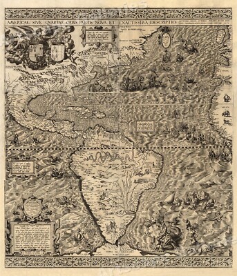
Buy It Now
$5.95 Shipping Condition: New Location: Las Vegas, United States The New World 1562 Size: 20" x 24" 51 cm x 61 cm) x Also Available in 24" x 28" from our eBay Store This is a great Classic Map originally ... morePublished circa 1562. This Map shows the America's as it was known in the 1500's. Includes texts in cartouche. Statements of dedication, coats-of-arms, ill. of allegorical f igure"Victoria" And ill. of sailing ships at sea and imaginary marine creatures. The wording on the map reads: Americae sive qvartae orbis partis nova et exactissima descriptio/ avtore Diego Gvtiero Philippi Regis Hisp. etc. Cosmographo; Hiero. Cock excvde 1562; Hieronymus Cock excude cum gratia et priuilegio 1562" This poster. Which evokes the vivid images of a simpler time, is a custom reproduction printed on 68lb Heavyweight Enhanced Matte Art Paper. This Historic Art Print is suitable for framing. Mounting or direct display on any wall! 000 Artscape Galleries/ Posters Past More Prints and Posters Available from our eBay Store! Shipping price includes delivery confirmation. We combine shipping for multiple purchases- add $1.00 for each additional poster. All posters are professionally packaged to ensure that they arrive safely and undamaged: Your poster is first rolled and inserted into a plastic sleeve before being placed into a Heavy-Duty mailing tube for delivery. We stand behind the quality of every poster. If you are not satisfied with your purchase. Please contact us within 30 days to arrange for either an exchange or a full refund. gsrx_vers_468(GS 6.4(468)
Buy It Now
$5.95 Shipping Condition: New Location: Las Vegas, United States Year: 1661. Haemisphaerium Sceno Graphicum - Celestial Chart of the Zodiac. A beautiful and unique celestial chart by Henricus Hondius. Shows signs of ... morethe zodiac above “Australis Incognito” (Australia unknown) and the Southern Hemisphere.
Free Shipping Location: Schertz, United States This is an Authentic / Original Antique Atlas Map. It is not *NEW* or in *NEW* condition, it was printed in the year indicated. We sell only Old Antique ... moreMaps, not prints, copies or posters. See Photo for best description, this is the actual map you will receive.
Free Shipping Location: Schertz, United States This is an Authentic / Original Antique Atlas Map. It is not *NEW* or in *NEW* condition, it was printed in the year indicated. We sell only Old Antique ... moreMaps, not prints, copies or posters. See Photo for best description, this is the actual map you will receive.
Free Shipping Location: Schertz, United States This is an Authentic / Original Antique Atlas Map. It is not *NEW* or in *NEW* condition, it was printed in the year indicated. We sell only Old Antique ... moreMaps, not prints, copies or posters. See Photo for best description, this is the actual map you will receive.
Buy It Now
$6.95 Shipping Location: Dover, United States Issued 1882, Chicago by Rand McNally & Co. Original center fold as issued. Large late 19th century color lithographed map.
Buy It Now
$5.95 Shipping Condition: New Location: Las Vegas, United States Year: 1589. “Vibrant and bright! Pic does not do it justice.looks amazing!”. Each of our prints are custom reproductions printed on 68lb Heavyweight Enhanced ... moreMatte Art Paper. These Historic Art Prints are suitable for framing, mounting or direct display on any wall!
Buy It Now
$6.00 Shipping Location: Carefree, United States ORIGINAL 1896 ANTIQUE MAP OF THE WORLD. MAP SHOWS CONTINENTS, WATERWAYS, LARGE CITIES, OCEAN CURRENTS AND HAS A MARINERS COMPASS AT LOWER RIGHT CORNER. ... moreLIST OF AREA OF WATER BELOW TITLE. CONDITION IS FAIR-DISCOLORATION AND STAINING, CENTER CREASE AS ISSUED, MAP AND COATS OF ARMS IMAGE ON REVERSE.
Free Shipping Location: Schertz, United States Explore the world of 1856 with this antique original atlas map. This 11x13 inches map showcases the East-West world hemispheres, mountains, and rivers. ... moreCreated by S.S. Cornell, a renowned cartographer and publisher, this map is a perfect addition to your collection. With each purchase, you will also be contributing to the Tunnel to Towers charity as 10% of the sale goes to the organization. The map is in good shape, and you will be pleased with the detail and quality of the map. Don't miss out on the opportunity to own a piece of history.
Buy It Now
$5.95 Shipping Condition: New Location: Las Vegas, United States Of allegorical f igure "Victoria", and ill. Cosmographo ; Hiero. Cock excvde 1562 ; Hieronymus Cock excude cum gratia et priuilegio 1562". Year: 1562. ... more“Vibrant and bright! Pic does not do it justice.looks amazing!”.
Buy It Now
$5.95 Shipping Location: El Prado, United States This map is on book plate paper and is foxing/tanning due to age. Engineers, New York, as is this one. The last 4 photos are for information only and ... moreare not included in this sale.
Buy It Now
$5.95 Shipping Condition: New Location: Las Vegas, United States This great Historic Map print shows the British Empire throughout the world exhibited in one view. Year: 1850. British Empire throughout the World exhibited ... morein one view. “Vibrant and bright! Pic does not do it justice.looks amazing!”.
Buy It Now
$5.95 Shipping Condition: New Location: Las Vegas, United States A new map of the world : with all the new discoveries by Capt. Cook. Each of our prints are custom reproductions printed on 68lb Heavyweight Enhanced ... moreMatte Art Paper. These Historic Art Prints are suitable for framing, mounting or direct display on any wall!
Buy It Now
$6.00 Shipping Location: Carefree, United States RARE ORIGINAL ANTIQUE 1889 MAP OF THE NORTHPOLAR REGION SHOWING RECENT ARCTIC DISCOVERIES. MAP IS BEAUTIFULLY COLORED AND VERY DETAILED. SOURCE- CRAM'S ... moreUNRIVALED ATLAS OF THE WORLD-1889. PUBLISHED BY- GEORGE F. CRAM.
$6.00 Shipping Location: Neuendettelsau, Germany Age: published Amsterdam, Bernard, 1715. Original engraving from Voyages au Nord.
Buy It Now
Free Shipping Location: Schertz, United States This is a rare antique map from 1853 featuring South Asia, Hindoostan, Siam, Arabia, and Tibet. The map is hand-colored and comes in an atlas format measuring ... more12x18 inches. It was published by J.W. Lowery and is an original, not a reproduction. It is a valuable addition to any map or antique collection. Free shipping is available within the USA and shipping costs outside the USA will be calculated accordingly. The map is in excellent condition and would make a great gift or decoration for a home or office.
Buy It Now
$82.10 Shipping Location: Wetmore, United States Map Size, 16”X 20”.
Buy It Now
$8.30 Shipping Location: Celina, United States Cover and back cover coming off, maps in good condition, binding is not holding up many pages loose from binding
|
|
|
In
|
1720 Old World Exploration Map Historic Print - 16x24
Mappemonde a l'usage du Roy Size: 16" x 24" 41 cm x 61 cm) x Also Available in 24" x 36" from our eBay Store This is a great Classic Map originally Published circa 1720. This Map. By Guillaume Delisle, shows The known world of the early 1700's. This poster. Which evokes the vivid images of a simpler time, is a custom reproduction printed on 68lb Heavyweight Enhanced Matte Art Paper. This Historic Art Print is suitable for framing. Mounting or direct display on any wall! 000 Artscape Galleries/ Posters Past More Prints and Posters Available from our eBay Store! Shipping price includes delivery confirmation. We combine shipping for multiple purchases- add $1.00 for each additional poster. All posters are professionally packaged to ensure that they arrive safely and undamaged: Your poster is first rolled and inserted ... moreinto a plastic sleeve before being placed into a Heavy-Duty mailing tube for delivery. We stand behind the quality of every poster. If you are not satisfied with your purchase. Please contact us within 30 days to arrange for either an exchange or a full refund. gsrx_vers_468(GS 6.4(468)
|
|
|
Original Antique Map - THE WORLD AS KNOWN TO THE ANCIENTS - 1843, A & C Black
THE WORLD AS KNOWN TO THE ANCIENTS Edinburgh: A. C. Black- 1843 By W. Hughes Sheet size: 17" x 12" This is a genuine antique map. Not a reproduction. As such, some age toning or signs of handling are to be expected. Any significant flaws or defects beyond this are noted below. Hand coloured boundaries. Good condition. Slightly tanned and chipped around edges. Some dusty marks. A couple of stains to lower left corner, but generally clean and neat. Click on pictures to enlarge in a new window I am happy to answer questions or provide whatever information I can. Returns I have tried to provide a description that is fair and accurate. Full refund. Plus cost of return postage, if this lot has been misrepresented. If. For any other reason, you are not satisfied with your purchase, I will give a full refund. But postage may be at buyer's ... moreexpense. Payment PayPal Cheques drawn on any UK account Direct Bank Transfer Banker's Drafts or Postal Orders in GB£ only Buyers outside the UK: PayPal only Please make payment within 7 days. Thankyou Postage Postage by 2nd class mail to the UK. Or standard airmail. Alternative delivery methods at buyer's request. I will combine postage for multiple lots wherever possible.
|
|
|
Map of the Known World c1720 Map Art Print - 24x36
Mappemonde a l'usage du Roy Size: 24" x 36" 61 cm x 91 cm) x Also Available in 16" x 24" from our eBay Store This is a great Classic Map originally Published circa 1720. This Map. By Guillaume Delisle, shows The known world of the early 1700's. This poster. Which evokes the vivid images of a simpler time, is a custom reproduction printed on 68lb Heavyweight Enhanced Matte Art Paper. This Historic Art Print is suitable for framing. Mounting or direct display on any wall! 000 Artscape Galleries/ Posters Past More Prints and Posters Available from our eBay Store! Shipping price includes delivery confirmation. We combine shipping for multiple purchases- add $1.00 for each additional poster. All posters are professionally packaged to ensure that they arrive safely and undamaged: Your poster is first rolled and inserted ... moreinto a plastic sleeve before being placed into a Heavy-Duty mailing tube for delivery. We stand behind the quality of every poster. If you are not satisfied with your purchase. Please contact us within 30 days to arrange for either an exchange or a full refund. gsrx_vers_468(GS 6.4(468)
|
|
|
Wall Art Old World Ortelius Map 1589 Maris Pacifici by Ortelius 13x19
Very Detailed Map Reproduction'Maris Pacifici' by Abraham Ortelius Published 1589 This map was published in 1589. It was not only the first printed map of the Pacific. But it also showed the Americas for the first time. Size(13x19) inches Ships rolled- Bubble wrapped- Boxed for protection Detailed reproduction of an original vintage two-dimensional Ink Map Printed on ACID FREE professional quality paper. We use the Giclee printing method using HIGH DEFINITION INKS that have LIGHT RESISTANCE& PRINT LONGEVITY. The quality of the Giclee prints rivals traditional silver-halide and gelatin printing processes. It is commonly found in museums. Art galleries, and photographic galleries. 800x600 Normal 0 false false false EN-US X-NONE X-NONE MicrosoftInternetExplorer4* Watermark will be removed on ordered picture NOT SATISFIED? SEND IT ... moreBACK WITHIN 30 DAYS OF RECEIPT. JUST RETURN THE ITEM IN ITS ORIGINAL CONDITION FOR A FULL REFUND WE SHIP WORLDWIDE. All buyers are always welcome to inquire prior to bidding/buying for shipping quotes, questions. INTERNATIONAL FEES: Import duties. Taxes and charges are not included in the item price or shipping charges. These charges are the buyer’s responsibility. Please check with your country’s customs office to determine what these additional costs will be prior to bidding/buying. Please provide your phone number with your payment. It is required by PayPal/USPS when printing labels. If not provided can result in delay of shipment. DELIVERY: Monday through Saturday(excluding Holidays and Sundays) We ship your package approx. 1- 2 business days after confirmation of payment has been received. On Feb-25-10 at 21:41:45 PST. Seller added the following information: Normal 0 false false false EN-US X-NONE X-NONE MicrosoftInternetExplorer4 About our RESTORATION PROCESS All our reproduction art print and photographs have been meticulously restored and digitally enhanced fo
|
|
|
WORLD MAP AFRICA EUROPE ASIA AMERICA COL COPPER ENGRAVING DESING 1747 #62
Produktbeschreibung: Decorative coloured copper engraving map out of: Auxilia Historica oder Behuelf zu denen historischen und dazu erforderlichen Wissenschafften. by Anselm Desing, Regensburg. 1747 A.D. World Map"I. Theils Hemisphaerium Occidentale. Hemisphaerium Orientale. Author: Anselm Desing( 15th March 1699 in Amberg; 17. December 1772 in the convent Ensdorf(Upper Palatinate) was a catholic philosopher. Historian and educator. Description: You bid on a decorative coloured copper engraving map by Anselm Desing. Out of"Auxilia Hostorica oder Behuelf zu denen historischen und dazu erforderlichen Wissenschafften. printed 1747 in Regensburg. The map shows the world in two hemispheres. Condition: very good condition slightly browing. Hardly stains Please have a look at the pictures! Size of the leaf ca. 16.7 x 14.8 cm. Size of the ... moremap ca. 11.1 x 13.2 cm. Dekorativ kolorierte Kupferstichkarte aus: Auxilia Historica oder Behuelf zu denen historischen und dazu erforderlichen Wissenschafften. von Anselm Desing, Regensburg. 1747 A.D. Weltkarte"I. Theils Hemisphaerium Occidentale. Hemisphaerium Orientale. Autor: Anselm Desing( 15. März 1699 in Amberg; 17. Dezember 1772 in Kloster Ensdorf(Oberpfalz) war ein katholischer Philosoph. Historiker und Pädagoge. Beschreibung: Sie bieten hier auf eine dekorativ kolorierte Kupferstichkarte von Anselm Desing aus"Auxilia Hostorica oder Behuelf zu denen historischen und dazu erforderlichen Wissenschafften" Gedruckt 1747 in Regensburg. Die Karte zeigt die Welt in zwei Hemisphären. Zustand: sehr guter Zustand leicht gebräunt. Kaum fleckig Bitte sehen Sie sich die Bilder an! Größe des Blattes ca. 16.7 x 14,8 cm Größe der Karte ca. 11.1 x 13,2 cm Zahlungshinweise: Bei mir können Sie wie Folgt zahlen: per Überweisung(payment via bank transfer) via Pay Pal oder Bar bei Selbstabholung(cash and pick up) Weitere Einzelheiten teile ich Ihnen umgehend nach erfolgreichem Abschluß der Auktion mit! Fu
|
|
|
Old World Map - 1691French Map of Kamianets - Podilskyi in Western Ukraine 11x14
Detailed World Map Reproduction French Map of Kamianets- Podilskyi in Western Ukraine Year 1691* Ready for framing with printed embedded matte! Size(11x14) inches Printed on ACID FREE professional paper. We use the Giclee printing method using HIGH DEFINITION INKS that have LIGHT RESISTANCE& PRINT LONGEVITY. The quality of the Giclee prints rivals traditional silver-halide and gelatin printing processes. It is commonly found in museums. Art galleries, and photographic galleries. Watermark will be removed on ordered picture NOT SATISFIED? SEND IT BACK WITHIN 30 days OF RECEIPT. JUST RETURN THE ITEM IN ITS ORIGINAL CONDITION FOR A FULL REFUND WE SHIP WORLDWIDE. All buyers are always welcome to inquire prior to bidding/buying for shipping quotes, questions. INTERNATIONAL FEES: Import duties. Taxes and charges are not included in the item ... moreprice or shipping charges. These charges are the buyer’s responsibility. Please check with your country’s customs office to determine what these additional costs will be prior to bidding/buying. Please provide your phone number with your payment. It is required by PayPal/USPS when printing labels. If not provided can result in delay of shipment. DELIVERY: Monday through Saturday(excluding Holidays and Sundays) We ship your package approx. 1- 2 business days after confirmation of payment has been received. On Dec-13-09 at 22:41:06 PST. Seller added the following information: On Feb-09-10 at 09:33:46 PST. Seller added the following information: Normal 0 false false false EN-US X-NONE X-NONE MicrosoftInternetExplorer4 About our RESTORATION PROCESS All our reproduction art print and photographs have been meticulously restored and digitally enhanced for clarity(unless noted in the description) We repair tears. Scratches, dust spots and at times color corrections to preserve the original integrity of the artist or photographer. Many other sellers do not provide this service. We guarantee our prints or your money back includ
|
|
|
1565 Known World Map Gastaldi Bertelli Americas - 24x40
Universale Descrittione di Tutta la Terra Conoscivta fin Qui- 1565 Size: 24" x 40" 61 cm x 102 cm) x Also Available in 14" x 24" from our eBay Store This is a great Classic Map originally Published circa 1565. This Map. Etched by Fernando Bertelli was based on an earlier map by Giacomo Gastaldi. It shows the world as it was known in the mid 1500's. This poster. Which evokes the vivid images of a simpler time, is a custom reproduction printed on 68lb Heavyweight Enhanced Matte Art Paper. This Historic Art Print is suitable for framing. Mounting or direct display on any wall! 000 Artscape Galleries/ Posters Past More Prints and Posters Available from our eBay Store! Shipping price includes delivery confirmation. We combine shipping for multiple purchases- add $1.00 for each additional poster. All posters are professionally ... morepackaged to ensure that they arrive safely and undamaged: Your poster is first rolled and inserted into a plastic sleeve before being placed into a Heavy-Duty mailing tube for delivery. We stand behind the quality of every poster. If you are not satisfied with your purchase. Please contact us within 30 days to arrange for either an exchange or a full refund. gsrx_vers_468(GS 6.4(468)
|
|
|
Antique Vintage Rare World Map North and South America Africa and Europe 1700's
The Atlantic Ocean by Governor Pownall. F.R.S. Engraved nautical chart showing currents. Trade winds, rhumb lines, and sailing courses. Depths in soundings. Includes 5 coastal profiles. Prime meridians: London and Ferro. Published May 12th 1791, 53 Fleet Street, London. Map is 222 yrs. old. Its shows wear like it was used for navigation on a ship. Not a reproduction. Map is large measuring 26' by 20' with frame)36' by 24' Governor pownall was a british governor of two states. An author and maker of this map, also a friend of Bejamin Franklin. Map condition: map show wear(yellowing. Staining and small tears thoughout, inculding a very small tear in upper left corner, its split down the middle, comes from atlas or book. It has been restored buy a museum proffesional. UV Plexi glass, acid free matt board, foam board and acid ... morefree tape attaches both pieces of map, its housed in a museum quality frame, and preserved for many more years of viewing, this map shows really nice! looks better in person, pictures dont do it justice. Please look at pictures for condition and quality. Starting bid.99 cent with low reserve for this large map. Check out my store for other great pieces! Powered by The free listing tool. List your items fast and easy and manage your active items.
|
|
|
LARGE 1890 ANTIQUE MAP OF GREECE HELLENIC WORLD GREEK
Index words: greeceland greek ionion ancient greece engraving eurolandscape] INVENTORY#PEOgreece- 00 138 GENUINE ANTIQUE PRINT. NOT A MODERN REPRODUCTION. THIS FULL COLOR CHROMOLITHOGRAPHIC STYLE PRINT IS ACTUALLY OVER 100 YEARS OLD. Lovely and scarce print produced in 1890. TITLE: GREECE AS CENTRE OF THE HELLENIC WORLD TYPE OF PRINT: FULL COLOR ANTIQUE PRINT. Produced one-side only. Shown cropped in scan to save on file size, but actual margins ample and overall print is larger than shown in scan. Genuine original antique print. Condition: Very Fine. No flaws- original folio folds as issued. No age spots. EXCELLENT! MEASURES ABOUT 7 X 11" BUY IT NOW: available only until the first person bids- if you want to be sure of not getting outbid. Just click on BUY IT NOW and the lot's all yours. I'll be posting MANY engravings this ... moreweekend- just click on VIEW SELLERS OTHER AUCTIONS for a complete listing. combine wins since ALL engravings you win will be covered under the one-time postage/mailing cost! NO RESERVES— highest bidder gets the lot! Questions? Please just email me. POSTAGE/PACKAGING.INTERNATIONAL/ ETC. TERMS FOR THIS ITEM US bidders. Payment with PAYPAL. If you are unable to use paypal that's okay, just email me for other options. you can use a VISA or MC through paypal) CANADA and INTERNATIONAL BIDDERS: Payment by PAYPAL. If you are unable to use paypal please email me prior to bidding for other payment options. If you have questions about payment options. Please email me before bidding. PAYMENT MUST BE RECEIVED WITHIN 10 DAYS OF AUCTION CLOSE UNLESS ARRANGEMENTS ARE MADE PRIOR TO BIDDING. I reserve the right to relist unpaid items and contact eBay regarding non-payment. I COMBINE ON SHIPPING! IF YOU ARE ORDERING MORE THAN ONE PRINT AND PAYING FOR ALL ITEMS AT THE SAME TIME FOR THE SAME PACKAGE YOU PAY POSTAGE FOR ONLY THE LARGEST PRINT BEING BOUGHT- ALL OTHER ITEMS ARE POSTPAID IN THE SAME PACKAGE. PLEASE EMAIL ME IF YOU NEED A COMBINED INVOICE. Questions? Please just email me. FR
|
|
|
World Map - Moses Pitt 1681
You are bidding on a'very expensive' piece of art(per the generous relative that gave it to us) My knowledge is limited with respect to art. Or antiques; but I personally love this piece. Magnificent, beautiful, elegant, sophisticated; the detail is exquisite, and unique. The map reads: Nova Totius Terrarum Orbis Geographica Ac Hydrographica Tabula" and as you can see from the pictures it is from an original engraving by Moses Pitt in 1681. I wanted to keep this, but unfortunately I have to let it go. Please feel free to contact me with any questions or concerns you may have. Good Luck& Happy Bidding! Posted with
|
|
|
1720 LIMIERS Atlas World planet systems map Copernic Brahe & Cartesio systemes
Sistema di Copernico di Ticone Brahe e del Cartesio 1720 From the book: La Scienza delle persone di corte. Di spada by Chevigni& Limiers 1720 Very rare Italian folding planet map See pictures Page size is 23 x 17.5 cm Page is bright& e ngravings are still clear Text in Italian Foldlines as issued. One of the folds has a 3.5cm split on lower part of the page but no loss. Blank on reverse Uncoloured Payments by Paypal please.
|
|
|
Wall Art Old World Map Ortelius 1570 -Typvs Orbis Terrarvm 11x17
Wall Art Old World Map'Theatrum Orbis Terrarum' Normal 0 false false false EN-US X-NONE X-NONE MicrosoftInternetExplorer4 Normal 0 false false false EN-US X-NONE X-NONE MicrosoftInternetExplorer4 by Abraham Ortelius Year 1570* Framing Size(11x17) inches Detailed reproduction of an original vintage two-dimensional map. Printed on ACID FREE professional quality paper. We use the Giclee printing method using HIGH DEFINITION INKS that have LIGHT RESISTANCE& PRINT LONGEVITY. The quality of the Giclee prints rivals traditional silver-halide and gelatin printing processes. It is commonly found in museums. Art galleries, and photographic galleries. Watermark will be removed on ordered picture NOT SATISFIED? SEND IT BACK WITHIN 30 days OF RECEIPT. JUST RETURN THE ITEM IN ITS ORIGINAL CONDITION FOR A FULL REFUND WE SHIP WORLDWIDE. All buyers ... moreare always welcome to inquire prior to bidding/buying for shipping quotes, questions. INTERNATIONAL FEES: Import duties. Taxes and charges are not included in the item price or shipping charges. These charges are the buyer’s responsibility. Please check with your country’s customs office to determine what these additional costs will be prior to bidding/buying. Please provide your phone number with your payment. It is required by PayPal/USPS when printing labels. If not provided can result in delay of shipment. DELIVERY: Monday through Saturday(excluding Holidays and Sundays) We ship your package approx. 1- 2 business days after confirmation of payment has been received. On Dec-13-09 at 22:41:06 PST. Seller added the following information: On Feb-09-10 at 09:33:46 PST. Seller added the following information: Normal 0 false false false EN-US X-NONE X-NONE MicrosoftInternetExplorer4 About our RESTORATION PROCESS All our reproduction art print and photographs have been meticulously restored and digitally enhanced for clarity(unless noted in the description) We repai
|
|
|
Antique Vintage Style World Map Decorative wooden suitcase (FH 004B)
Wooden box and trunk. Size: 12.6' X 8.7' X 4.3' 32cm X 22cm X 11cm) Decorative trunk box that is great for storage and decoration. Old fashioned hardware adds to antique look. All handmade. We care for our reputation. Posted with
|
|
|
WORLD GLOBE HYDROGRAPHY 1870 DUFOUR VERY LARGE ORIGINAL ANTIQUE ENGRAVED MAP
Title: MAPPE-MONDE PLANISPHERIQUE PHYSIQUE ET IDROGRAPHIQUE' Author: Dufour. Auguste-Henri( 1798- 1865) Engraver: Dyonnet. Charles(1822- 1880) Source: Grand atlas Universel physique. Historique et politique geographie ancienne et moderne' Date: 1870ca. Paris. Technique: Steel Engraving. Paper size: 82.5x60 cm. Condition: Dark impression on good paper. Original watercolor. Margins with some tears. Small restoration of the bottom centerfold. Almost unnoticeable foxings on engraved area. Very good conditions. Conditions are as you can see in the images. All of the engravings and books I sell are original. I guarantee all of my engravings to be authentic. Please examine the images provided carefully. And if you have any questions, please ask and I will be happy to help. Any item purchased from me may be returned for any reason for a full ... morerefund. If you buy more than one item. You have to pay only one shipping cost.
|
|
|
World Globular Hemispheres Projection Mts. of Moon 1829 antique engraved map
World Globular Hemispheres Projection Mts. of Moon 1829 antique engraved map The World on a Globular Projection Issued 1829.Connecticut by D.F. Robinson Fine original antique engraved map. Printed in the 19th century on quality paper which retains its inherent structural flexibility and soundness. With beautiful original hand color. In Good+ or better condition. 2" split to bottom centerfold now closed on back with archival tape, light uniform age wear and some minor scattered small age staining, neither of these detract from the overall attractiveness of the image[note: we grade very conservatively and always seek to disclose any noteworthy flaws] We note Australia is still called New Holland and the mythical range Mountains of the Moon is seen prominently dividing the continent in half. The printed area remains visually pleasing. A ... morenice impression of an interesting antique map. Any minor defects along the sheet edges and in the margins may be seen in the photos. Sheet measures c. 18" W x 11 3/8" H. Engraved area measures c. 16 3/8" W x 10" H. Original centerfold line as issued. 31457] note: All old sheets of printed paper possibly have short edge splits. Each sheet has existed for a very long time and has probably been handled repeatedly in the course of it's existence. It has a history unique to it as an object. Most of the time any edge splits are short. Minor, insignificant and have been closed- either long ago or more recently with small pieces of archival tape. Most often these splits are trivial and easy to overlook visually. Basically, they would not significantly affect the piece adversely. The item is offered as seen. Please look carefully and make your decision knowing this antique image is nice. But it is not in perfect"like new" condition. However, with whatever flaws it possesses, it remains entirely worthy of ownership and inclusion in any related collection. We feel it will prove very pleasing to its new owner. We stand behind everything we sell. Everything
|
|
|
World Map Reproduction Nicholas Van Geelkercken Masketeers Orbis Terrarum 1600
Orbis Terrarum Descriptio Duobis Planis Hemisphaeriis Comprehesa This reproduction was created by Masketeers Inc. out of W. Virginia in roughly 1964 Wood outside The Hemispheres made of brass I ALWAYS TAKE OFFERS. SEND ME A MESSAGE Uploaded with Uploaded with Uploaded with Uploaded with Uploaded with Uploaded with Uploaded with Uploaded with
|
|
|
Antique Framed Gold Foil Map of The World 'Nova Totivs Terrarom' Blaeu Wall Map
You are bidding for a lovely Antique reproduction Framed Gold Foil Map of The World'Nova Totivs Terrarom Sive Novi Orbis Tabvla' Blaeu Wall Map. As pictured 1605c Size: L 56cm x W 45cm
|
|
|
THE WORLD Walker Hand Coloured Antique Map 1816
THE WORLD Walker Hand Coloured Antique Map 1816, THE WORLD Walker Hand Coloured Antique Map 1816 THE WORLD ON MERCATORS PROJECTION A fine and attractive. Copper engraved antique map of The World, with original hand colouring. Drawn& engraved by Thomson for"Walker's New or Universal Atlas" published London by Barnard& Farley 1816. Fine. Virtually unmarked condition with foldlines as issued, blank verso. Measuring approx. 10" x 9" 260mm x 230mm) overall. Please scroll to close ups for a further image. A GENUINE ANTIQUE MAP GUARANTEED OVER 190 YEARS OLD FROM LINDISFARNE PRINTS M4213 SHIPPING Within UK- £2.95 via Royal Mail First class. From UK to Europe- £3.95 via Royal Mail Airmail. From the UK to USA and rest of the world- £4.95 via Royal Mail Airmail. TWO ITEMS WILL BE COMBINED. WITH ONE SHIPPING ... moreCHARGE. THREE ITEMS OR MORE SHIPPED FREE OF CHARGE. WORLDWIDE! Closeups, Shipping Process, Two items are always combined for shipping and three items or more are shipped free of charge. Worldwide"Please see item description for postage costs" Payment Options, All major Credit and debit cards via PAYPAL. Personal cheque drawn on UK banks only. Postal Orders from UK post offices only. Bank transfer- please email for details. About Us, Lindisfarne Prints is a small family business specialising in genuine antique maps and prints at affordable prices.Established in 1995 and trading online since 2000. We pride ourselves on accurate descriptions, good communications, rapid service and fair prices. We are proud to maintain a 100% positive feedback rating which we hope reflects this.To avoid confusion, no item less than 100 years old is ever offered for sale. We do not deal in reproductions, facsimiles or modern copies of any kind. So please buy with confidence in the safe knowledge that authenticity is unfailingly assured. Return Policy, Customer satisfaction is paramount and any item not exactly as described will be accepted for return. Without hesitation. The buyer is re
|
|
|
1835 Thomas Bradford Atlas Map - World Mountains - Very Rare
You are bidding on a very extremely rare and 100% authentic antique hand colored map of the above cartographer/map maker. Region, and year. I am a very close friend of eBay seller DIVEL3. My antique maps and reputation are 100% fully endorsed and I am recommended by DIVEL3. So bid with absolute 100% confidence and assurance on this item. Please contact and send a message to DIVEL3 and he will confirm this. I sell only original antique maps. This is NOT a copy or reproduction and is an original antique map from the year shown. General Description: The atlas that this map is from is extremely rare and hard to find because there are not too many left. A complete 1835 Bradford Comprehensive Atlas edition can sell upwards for $7.000! This is a stunning and very detailed map which is hand colored in wonderfully intense colors. Political boundaries ... moreas well as individual regions/counties and shows towns. Roads, railways, rivers, lakes, bays, harbors, islands and other important places are shown. The map is in great condition considering the age of the map. The overall size of the map sheet is large at approximately 11 inches by 9 inches. The map is far more beautiful than my pictures show. This map will look wonderful when matted and framed and will be a great addition to your collection. The map is a 100% original and genuine antique map created and printed in the year shown. Payment Terms: US bidders: Terms: PayPal is accepted. Payment is expected within 7 days of the end of the auction. I ship a couple of times per week. All sales are final so bid carefully and ask any questions prior to the end of the auction. I ship these rolled and in strong reinforced heavy tubes. Buyer will pay shipping and handling charges of $8.00 for the US. Insurance starts at $5.00. I will combine the shipping charges if you win more than one item. International bidders: Terms: PayPal is accepted. Payment is expected within 7 days of the end of the auction. All sales are final so bid carefully and ask any questions prior to the end of th
|
|
|
1895 GEOGRAPHY HISTORY WORLD MAPS Antique Map
i000000. 1895 GEOGRAPHY HISTORY WORLD MAPS Antique Map Click to Enlarge Light stripe on the middle of the print is from the scanner(has original center fold) Original old German map/double page book plate. This is an authentic antique(not a modern reproduction)beautiful map comes from a German lexicon. Very decorative.Looks great when framed. Printed by Bibliographisches Institut Leipzig.1895. The overall size of this print with margins approx 12" x 10" inches and suitable for framing. The print was folded inside the book and has original centrefold. Condition can be see from the scan. PLEASE NOTE! FOR MULTIPLE BUYERS. All combined items must be paid once a week. If the items are not paid the eBay seller assistant will automatically open a case for unpaid items. After reading all of auction. Please ask any and all questions BEFORE ... morebidding! Thank You If you have questions or problems before OR after you receive an item. PLEASE contact us ASAP. We leave feedback for everyone. Once transaction is complete and feedback has been left for us. We believe in and encourage good communication! We work hard to keep our customers happy! We accept returns ONLY if there is a problem(or damage) on the item. Shipping from Europe.Slovakia. Multiple winner safe shipping cost. Shipping is same for 1-3 prints. Please allow approximately two-three weeks for delivery from Europe after payment received. Payment must be received up to 7 days. Payment by PayPal. SORRY but we do not accept eChecks. DO NOT DUPLICATE OR COPY! Template Made By: © Inkfrog Template Center Auction Templates. Logos, Store fronts and more! inkfrog terapeak.
|
|
|
WORLD WAR 1 - LEATHER MAP CASE
PLEASE SEE ALL OUR PICTURES. USING THE ARROW IN THE DROP DOWN BOX ON THE RIGHT HAND SIDE OF PICS. NO MAP INSIDE PLEASE EMAIL US WITH ANY QUESTIONS PRIOR TO BIDDING. WE WILL ALWAYS DO OUR BEST TO ANSWER YOUR PARTICULAR QUESTIONS ON AN ITEM. ALSO TAKE A MOMENT TO VIEW OUR OTHER AUCTIONS. WE HAVE A VARIETY OF ESTATE ITEMS TO OFFER, BOTH ANTIQUE AND COLLECTIBLE. WE ARE NOT EXPERTS IN ANY ONE AREA.WE BUY AND SELL IT ALL AND ANYTHING! THANK YOU FOR VIEWING OUR AUCTIONS. WE DO COMBINE AND OR DISCOUNT SHIPPING AND SHIP INTERNATIONAL- PLEASE BE PATIENT. ALTHOUGH WE SHIP QUICKLY, WE LIVE IN RURAL AREA AND SOMETIMES THE MAIL IS SLOWER THAN OTHERS. THANKS IF THERE IS EVER A PROBLEM ALONG THE WAY. CONTACT US FOR HELP, BEFORE LEAVING A NEGATIVE OR NEUTRAL FEEDBACK! TOUR OUR STORE FOR GREAT BARGAINS AND BUY IT NOW- OR MAKE AN OFFER ON A BUY IT NOW STORE ... moreITEM IF YOU WOULD LIKE! CLICK ON THE QUICK LINK HERE TO OUR STORE http:stores.ebay.com/John-and-Debz-Ultimate-Collectibles
|
|
|
Mercator Projection World Comparative Rivers Europe 1843 Woodbridge antique map
Mercator Projection World Comparative Rivers Europe 1843 Woodbridge antique map Map of the World: Exhibiting the Eastern& Western Hemispheres and the Land Hemispheres. Together with a Comparative View of the Rivers and Lakes of the Two Continents Issued Boston. 1843 by WIlliam C. Woodbridge Fine original antique map. Printed in the mid-19th century, on quality paper which retains its inherent structural flexibility and soundness. Comparative length diagrams are at either side of the bottom below the spheres. In Good+ or better condition. Light uniform age wear, small light dampstain at bottom center edge, overall very presentable and attractive[note: we grade very conservatively and always seek to disclose any noteworthy flaws] The printed area remains visually pleasing. A nice impression of an interesting antique map which will look ... morenice when displayed. Sheet measures c. 12 1/4" W x 9 1/2" H. Printed area measures c. 10 1/4" W x 8 1/2" H. 31031] Any defects along the sheet edges and in the margins may be seen in the photos. note: All old sheets of printed paper possibly have short edge splits. Each sheet has existed for a very long time and has probably been handled repeatedly in the course of it's existence. It has a history unique to it as an object. Most of the time any edge splits are short. Minor, insignificant and have been closed- either long ago or more recently with small pieces of archival tape. Most often these splits are trivial and easy to overlook visually. Basically, they would not significantly affect the piece adversely. The item is offered as seen. Please look carefully and make your decision knowing this antique image is nice. But it is not in perfect"like new" condition. However, with whatever flaws it possesses, it remains entirely worthy of ownership and inclusion in any related collection. We feel it will prove very pleasing to its new owner. We stand behind everything we sell. Everything we offer is guaranteed to be an authentic original antique item
|
|
|
c1900 COPERNICUS WORLD SYSTEM MAP 1660 FACSIMILE Antique Litho Print H.Kraemer
i000000. C1900 COPERNICUS WORLD SYSTEM MAP 1660 FACSIMILE Antique Litho Print H.Kraemer Click to Enlarge Click to Enlarge Original old German litho print with a tissue guard/book plate(not a modern reproduction) by H.Kraemer. The print has been printed by Deutsches Verlagshaus Bong& Co. Berlin,Germany,circa 1900. Very decorative.It looks great when framed. The overall size of this print with margins approximately 11" x 7 3/4" Condition can be see from the scan. Has bend on the bottom field. The print in the original is more brighter and better. The scanner doesn't shown all beauty of a picture and can deform color. Colors of scan can differ from the original. PLEASE NOTE! FOR MULTIPLE BUYERS. All combined items must be paid once a week. We can hold them longer if you continue to buy and will not add a double shipping cost ... morebut will be added actual shipping cost. If the items are not paid in a 2 week(14 days) now the eBay will automatically open a case for unpaid item. After reading all of auction. Please ask any and all questions BEFORE bidding! Thank You If you have questions or problems before OR after you receive an item. PLEASE contact us ASAP. We leave feedback for everyone. Once transaction is complete and feedback has been left for us. We believe in and encourage good communication! We work hard to keep our customers happy! We accept returns ONLY if there is a problem(or damage) on the item. Shipping from Europe.Slovakia. Multiple winner safe shipping cost. Shipping is same for 1-3 prints. Please allow approximately two-three weeks for delivery from Europe after payment received. Payment must be received up to 7 days. Payment by PayPal. SORRY but we do not accept eChecks. DO NOT DUPLICATE OR COPY! Template Made By: © Inkfrog Template Center Auction Templates. Logos, Store fronts and more! inkfrog terapeak.
|
|
|
1650 Bahamas Caribbean Historic New World Map - 17x24
Cuba and Bahamas 1650 Size: 17" x 24" 43 cm x 61 cm) x Also Available in 24" x 34" from our eBay Store This is a great Classic Map originally Published circa 1650. This stylish old world Map shows part of the island of Cuba and of the Bahamas. This print would make a great Treasure Map! This poster. Which evokes the vivid images of a simpler time, is a custom reproduction printed on 68lb Heavyweight Enhanced Matte Art Paper. This Historic Art Print is suitable for framing. Mounting or direct display on any wall! 000 Artscape Galleries/ Posters Past More Prints and Posters Available from our eBay Store! Shipping price includes delivery confirmation. We combine shipping for multiple purchases- add $1.00 for each additional poster. All posters are professionally packaged to ensure that they arrive safely and undamaged: Your ... moreposter is first rolled and inserted into a plastic sleeve before being placed into a Heavy-Duty mailing tube for delivery. We stand behind the quality of every poster. If you are not satisfied with your purchase. Please contact us within 30 days to arrange for either an exchange or a full refund. gsrx_vers_468(GS 6.4(468)
|
|
|
Old Color World Map Dated 1587 in Mid-Century Frame, Typvs Orbis Terrarvm
Estate find. This colorful framed map measures approximately 17 1/2" X 12 3/4" inside border measurements) It has slight creases from being folded but is in really nice overall condition. I don't know how old the actual map is but it looks to have been framed in the 1940's to 1950's. It is dated 1587 in the lower right hand area, just above the circle in the corner. It would make a wonderful addition to a study room or lawyer/doctor office. Check out the other map I aquired at the same time. Will ship to Canada but will cost more to ship. Posted with the
|
|
|
1781 Vaugondy Double Hemisphere Map of The World
1781 Vaugondy Map- Mappe Monde The Vaugondy family produced a large number of atlases from about 1740 to the end of the century. Apart from the large'Atlas Universelle' and the small'Atlas Militaire' They allowed their maps to be'licensed' by other publishers, none more obviously so than in the many editions of'Methode abregee et facile pour apprendre la Geographie' dedicated to Mme Crozat. These went through many editions from about 1751 until well into the 1800's. This double hemisphere map of the World is from the issue of 1781. The map has a very interesting geography- the North American Arctic is unknown with Greenland attached to the continent and the West coast is unmapped. Eastern Australia and New Zealand are mostly unknown. Japan is very distorted with the partially mapped island of Jesso. The ... moresouthern continent is not shown except for the recent discovery of Cape Circoncision. In North America the map names N. Angleterre. Louisiana, N. Mexique, Californie, Canada, Labrador, Terre Neuve. The map measures 5.5" by 10.5" with several folds(as issued) Has later outline hand colouring, and is in good condition with light transference of the engraving across the folds, and some light creasing along one of the folds. The map is guaranteed to be over 220 years old. Shipping United States- Regular airmail $5.00US. Registered/insured airmail with tracking(optional) is an additional US$15.00 for a total of US$20.00. Canada- $3.00US for regular mail. $9.00US for registered mail. Canadian customers please add GST or HST as applicable. Sorry, we cannot arrange for pick up of ebay items. Rest of the world- Regular air mail $8.00US. Registered/insured airmail with tracking(optional) is is an additional US$15.00 for a total of US$23.00. Terms and Conditions Please note- We can only take responsibility for delivery if the optional registration/insurance is added. Regular airmail is usually very safe and reliable. But items sent by regular airmail are at the buyers risk- regul
|
|
|
World by Hemispheres Map: Authentic 1902 (Dated) Attractive and Fairly Detailed
1902 Engraved Color Map: The World by Hemispheres Satisfaction Guaranteed This is an authentic 100+ Year-Old Map; NOT a reproduction. This color map of the Eastern and Western Hemispheres is dated 1902 on the face and was engraved and printed by the Matthews-Northrup Works of Buffalo. NY. The map is printed on medium weight paper. Blank on the reverse. Sheet size is about 10" x 18" and printed with modest borders and a fold in the center. Condition is very good. The attached illustration is a fairly accurate representation of the map. The close-up image below is included to give an example of the engraving quality and detail. One or more of the following copyright statements appear on the face of this map This is an attractive map and would look good framed. Bid with confidence- Returnable for any reason within 10 days for prompt ... morerefund. Powered by The free listing tool. List your items fast and easy and manage your active items.
|
|
|
1799 Historic World Map Discoveries by Capt. Cook 14x24
A new map of the world: with all the new discoveries by Capt. Cook 1799 Size: 14" x 24" 36 cm x 61 cm) x Also Available in 24" x 42" from our eBay Store This is a great Classic Map originally Published circa 1799. This Map shows a map of the world in 1799 and the sailing routes of Captain Cook. Along with lines of magnetic variation and marine wind- direction arrows. The wording reads: A new map of the world: with all the new discoveries by Capt. Cook and other navigators: ornamented with the Solar System. The eclipses of the sun, moon& planets&c. by T. Kitchen, geographer. This poster. Which evokes the vivid images of a simpler time, is a custom reproduction printed on 68lb Heavyweight Enhanced Matte Art Paper. This Historic Art Print is suitable for framing. Mounting or direct display on any wall! 000 Artscape ... moreGalleries/ Posters Past More Prints and Posters Available from our eBay Store! Shipping price includes delivery confirmation. We combine shipping for multiple purchases- add $1.00 for each additional poster. All posters are professionally packaged to ensure that they arrive safely and undamaged: Your poster is first rolled and inserted into a plastic sleeve before being placed into a Heavy-Duty mailing tube for delivery. We stand behind the quality of every poster. If you are not satisfied with your purchase. Please contact us within 30 days to arrange for either an exchange or a full refund. gsrx_vers_468(GS 6.4(468) Lm3vhp.RcmdId ViewItemDescV4,RlogId p4%60bo7%60jtb9%3Fuk%601d72f%2Bjw%60%3Elm3vhp-13cd403f053-0xf6-
|
|
|
Antique Vintage Wooden Picture*Globe*Map*Old World*America*
Check out my! You bid on a vintagte wooden picture/globe/old world/America from thwe 60's. It is printed on paper and then glued on the wood frame. Size: 9 x 7.8" 23.5 x 20 cm) Used but good condition. See photos. Good Luck and Happy Bidding! Payments can be made by Paypal. IN EURO-Zone(IBAN/BIC/SWIFT) Shipping cost: USA/World: $ 14.00(insured) Deutschland: $ 9.50(versichert) Ask me questions prior bidding. Please rest assured it will be expertly packaged for safe arrival. View my other auctions please. I` m always combine shipping where possible.
|
|
|
1595 Map of the World, Quality Historic Print, Very Nice )) Iudocus Hondius
1595 Map of the WORLD* Wonderful detail! Historic Map Vera totius expeditionis nauticæ QUALITY QUALITY QUALITY! REPRODUCTION Original sells for $1000's Get it at a fraction of the cost. We use archival quality papers and ink 11mil high quality art paper* The size is 18.25" x 12.90" Looks amazing framed! All prints are delivered in a heavy duty poster tube for safe delivery. Customer satisfaction guaranteed! If for some reason you want to return the item. Or your print is damaged, you can return for a full refund no worries. WE COMBINE SHIPPING! If you buy more than one. Just wait for my invoice so I can adjust price! world15. WE SHIP ITMES OUT FAST If it's ordered by 11AM Pacific. We ship it same day:
|
|
|
1806 Map of the World, Quality Historic Print, Mexico, Florida, Caribbean,Island
1806 Map of the Caribbean* West Indies. Mexico, Gulf, Southern US Wonderful detail! Historic Map 19"x13" QUALITY QUALITY QUALITY! REPRODUCTION Original sells for $2000-$5000 Get it at a fraction of the cost. We use archival quality papers and ink 11mil high quality art paper Looks amazing framed! All prints are delivered in a heavy duty poster tube for safe delivery. Customer satisfaction guaranteed! If for some reason you want to return the item. Or your print is damaged, you can return for a full refund no worries. WE COMBINE SHIPPING! If you buy more than one. Just wait for my invoice so I can adjust price! 1806mex. WE SHIP ITMES OUT FAST If it's ordered by 11AM Pacific. We ship it same day:
|
|
|
MIE-MACHI NE, World War 2 Planning Target Map Dated 1945 Approx 20x22 Inches
World war 2 target map of Mie-machi neSheet 4445-lV NE. Prepared under the direction of the chief of engineers by the army map service. This map is double sided. 1-25000 scale May have creases or folds in map been Posted with
|
|
|
Aoga Shima World War 2 Planning Target Map Dated 1945 Approx 19x22 Inches
World war 2 target map of AOGA-SHIMA dated 1945 Sheet 6044 ll NW Prepared by the 30th engr. bast top Bn. AFMIDPAC with the assistance of the 1634th engr. photo mapping platoon. 1-25000 scale. Count our interval 20 meters.May have creases or folds in map been Posted with
|
|
|
VINTAGE A NEW AND ACCURAT MAP OF THE WORLD 1651
A NEW AN ACCURAT MAP OF THE W0RLD 1651 ITS 19 INCHES X 15 INCHES WITH FRAME ITS 231/2 INCHES X 20 INCHES IN A BEAUTIFUL EXPENSIVE DARK WOOD FRAME IN GOOD TO EXCELLENT CONDITION THANK YOU FOR LOOKING
|
|
|
1940s Ford Brochure With The New Yorkers Map Of The World Of Tomorrow
has folds and creases Very colorful and in good shape for its age Posted with
|
|
|
Nobeoka Sw Japa World War 2 Planning Map Approx 19x22 Inches. July 1945
World war 2 planning map of Nobeoka japan reproduced by the 30th engr. bast top. Bn afmispac no. Kyushu photo maps 1-25000 scale 2 sided for use by war and navy department a agencies only. First edition ams1. 1945. May have folds and creases, as is Posted with
|
|
|
Genuine Antique hand colored map of the World in hemispheres. A.H. Brue, 1833
Genuine antique map" Mappemonde en Deux Hemispheres" by Adrien Hubert Brue is dated 1833 and published in Paris. Impression is hand colored in outline and printed on sturdy paper with full margins. This attractive map shows nice detail of coastlines. Islands, mountain ranges, and waterways of the eastern and western hemispheres as known or imagined in the early 1800s. Map is in good condition with one small stain on the left border- not in image. Center fold as issued. Image measures 11 1/2" x 20" NOT A REPRODUCTION. All of our items are genuine antiques as described. 3.RcmdId ViewItemDescV4,RlogId p4%60bo7%60jtb9%3Fud.ro77%2861m25%3E3-13cd83de64c-0x10d-
|
|
|
c.1780 Genuine Antique map of World, Mercator projection. by R. Bonne
Genuine antique map"Planisphere Suivant la Projection de Mercator" by Rigobert Bonne. Published in Paris c. 1780. Copperplate map of the world exhibits interesting configuration of North America, the northern land masses, and eastern Asia. Map is in very good condition, clean, printed on heavy paper. Center fold as issued. Image measures 8 3/8" x 12 1/2" NOT A REPRODUCTION. All of our items are genuine antiques as described.
|
|
|
1720 Map of the WORLD, Earth, Historic Quality Print, Earope, America, Asia
1720 Map of the Earth* AMAZING DETAIL* The size is 12" x 19" Looks amazing framed! THIS IS AN EXACT REPRODUCTION DIRECTLY FROM THE ORIGINAL SOURCE All our giclée reproductions capture every detail of these evocative images. We use quality archival papers and inks All prints are delivered in a heavy duty poster tube for safe delivery. Customer satisfaction guaranteed! If for some reason you want to return the item. Or your print is damaged, you can return for a full refund no worries. earth2 WE COMBINE SHIPPING! If you buy more than one. Just wait for my invoice so I can adjust price!
|
|
|
30'S MARITIME DECO WORLD MAP SHIP LIGHT FIXTURE CHANDELIER-GORGEOUS!!!
30'S MARITIME DECO WORLD MAP SHIP LIGHT FIXTURE CHANDELIER-GORGEOUS! 30'S NAUTICAL MARITIME DECO LIGHT FIXTURE CHANDELIER! Today I am am listing a beautiful old 30's Nautical fixture. The colors are awesome in this large beautiful shade. The sockets and the wiring have been checked for safety. It is a 2 bulb fixture that is just AWESOME WHEN LIT OR UNLIT! The hang on this beauty is 9 inches from the ceiling to the bottom of the beautiful ship wheel finial. The large shade diameter is 15" The colors are just awesome. I will also have a minimum reserve that I will gladly share with anyone interested in owning this gorgeous old piece of our history! This will be awesome in a re model or even a new build! Don't miss out on this one. You don't see them very often anymore! RARE!
|
|
|
7 Old World Auctions ANTIQUE MAP REFERENCE Catalogs CARTOGRAPHY Illustrated
7 Old World Auctions ANTIQUE MAP REFERENCE Catalogs CARTOGRAPHY Illustrated"7 Issues of Old World Auction Catalogs" 2003 and 2004 Sales: 102/103/104/105/106/107/108 Wonderful Reference Source! Well Written& Documeted Entrees Illustrated Prices Realized For Previous Auction Listed at Beginning of Each Catalog Fine Condition Condition: All Issues in Fine Condition; Nice Collection! Seller to Provide Insurance as Part of Shipping& Handling to Domestic Customers. Insurance Provided Internationally When Available From USPS to Destination. If Insurance is not available to an International Shipping Destination. Buyer will be Required to E-mail a Statement(via the Ebay Contact System) Releasing the Seller of any Responsibility due to Loss or Damage during Shipping. If this is not received, the sale will be cancelled. Buyers are ... moreasked to promptly arrange payment details. Payment can be made by several methods including most major credit cards. Contact me at the store to arrange for direct payment by credit card. Canaday's Book Barn in Carlisle. Pa. 717-574-0092. Payment can also be made via Paypal. Canaday's Book Barn is a brick-and-mortar full service old& rare bookstore located in Carlisle. Pa. It is owned and operated by Ted Canaday and his wife, Tai. The bookstore is located in a 200+ year old stone Pennsylvania bank barn. With over 75.000 volumes of better used, out-of-print, collected, distinctive and rare books in all fields in addition to antique maps and prints, vintage posters and LPs, early postcards, photographs and ephemera, it is a browser's delight! Hours: Tuesday- Saturday 10am to 5pm EST. Address: 2269 Newville Rd. Carlisle. Pa. 17015. Tel: 717)574-0092.
|
|
|
MERCATOR'S WORLD Map Magazine Vikings Edmund Halley Holy Land Samuel Hearne Peru
MERCATOR'S WORLD Map Magazine Vikings Edmund Halley Holy Land Samuel Hearne Peru Complete original issue of Mercator's World. The Magazine of Maps, Exploration, and Discovery. This is Volume 5. Number 1, and the cover story discusses the Vikings visits to North America in 986. This article was written by Kirsten A. Seaver and includes images of old maps. Other features in the issue describe Samuel Hearne's search for the Coppermine River. The Inca legacy of border disputes between Ecuador and Peru, the Simmons collection of maps of the Holy Land, and the Atlantic voyages of Edmund Halley and his charts. This is the January/February 2000 edition. With 80 pages. The publisher of Mercator's World has since gone out of business. And back issues like this one are tough to find. Condition: It is in excellent condition, bright and ... moreclean. With no marks. Rips, or tears, sealed in plastic. We are pleased to offer it with our unconditional. Money-back guarantee. SHIPPING: We gladly ship anywhere in the World. And we use sturdy, professional packing materials to assure safe delivery. The shipping charges are as follows: Within the United States. Including Alaska, Hawaii, and APO addresses: $4.59 To Canada or Mexico: $12.29 To all other international destinations: $17.79(These charges reflect recent increases made by the United States Postal Service for international delivery. We will appreciate your prompt payment for this item. If you need more time or have any other questions about making your payment. Or if you may desire any special services, such as overnight delivery or tracking number, please contact us. Florida residents add 6.5% sales tax. Be sure to check our auction listings on eBay for other antique and collectible maps and ephemera. Simply click on the link below. Many of the items offered can be combined with this purchase so you can save on shipping. Make it even easier to keep track of our eBay store and auction offerings! Click to add us to your Favorites List. Your satisfaction is guaranteed
|
|
|
MERCATOR'S WORLD Map Magazine Scotland Ordnance Survey Rumsey Vinland Cellarius
MERCATOR'S WORLD Map Magazine Scotland Ordnance Survey Rumsey Vinland Cellarius Complete original issue of Mercator's World. The Magazine of Maps, Exploration, and Discovery. This is Volume 5. Number 5, and the cover story describes the 18th-century survey of Scotland and the birth of the Ordnance Survey. Other subjects in this include David Rumsey's online collection of antique maps and atlases. Shanawdithit's sketches of Newfoundland's topography, map screens, Heinrich Muess's 1710 map of Switzerland, the Stefánsson, Resen, and Thorláksson maps of Vinland, Rand McNally road atlases, weather loop maps, and Christopher Cellarius' Sicilia Antiqua. The scans below show a couple of the inside pages: This is the September/October 2000 edition. With 80 pages. The publisher of Mercator's World has since ... moregone out of business. And back issues like this one are tough to find. Condition: It is in excellent condition, bright and clean. With no marks. Rips, or tears, sealed in plastic. We are pleased to offer it with our unconditional. Money-back guarantee. SHIPPING: We gladly ship anywhere in the World. And we use sturdy, professional packing materials to assure safe delivery. The shipping charges are as follows: Within the United States. Including Alaska, Hawaii, and APO addresses: $4.59 To Canada or Mexico: $12.29 To all other international destinations: $17.79(These charges reflect recent increases made by the United States Postal Service for international delivery. We will appreciate your prompt payment for this item. If you need more time or have any other questions about making your payment. Or if you may desire any special services, such as overnight delivery or tracking number, please contact us. Florida residents add 6.5% sales tax. Be sure to check our auction listings on eBay for other antique and collectible maps and ephemera. Simply click on the link below. Many of the items offered can be combined with this purchase so you can save on shipping. Make it even easier to k
|
|
|
1997 MERCATOR'S WORLD Cellarius Celestial Map Magazine JAPAN Frisland Wind Heads
1997 MERCATOR'S WORLD Cellarius Celestial Map Magazine JAPAN Frisland Wind Heads Complete original issue of Mercator's World. The Magazine of Maps, Atlases, Globes and Charts. This is Volume 2. Number 1, with articles and stories on antique maps of Frisland, by F.J. Manasek, celestial maps, Japanese mapmaking, wind heads, maps on playing cards, fantasy worlds on maps, the Todhunter-Allen collection, the Ahousat people, and maps of the National Geographic Society, plus the magazine's regular features. The beautiful map portrayed on the cover is a 1660 sky chart by Andreas Cellarius. This magazine measures a generous 11" x 8-1/2" and has 82 pages. It was published in 1997. And evidently had a short press run because it was out of print shortly after publication; consequently, it is a difficult issue to find. Condition: ... moreThis issue of Mercator's World is in excellent. Like-new condition, bright and clean. With no marks. Rips, or tears, sealed in plastic. We are pleased to offer it with our unconditional. Money-back guarantee. SHIPPING: We gladly ship anywhere in the World. And we use sturdy, professional packing materials to assure safe delivery. The shipping charges are as follows: Within the United States. Including Alaska, Hawaii, and APO addresses: $4.59 To Canada or Mexico: $12.29 To all other international destinations: $17.79(These charges reflect recent increases made by the United States Postal Service for international delivery. We will appreciate your prompt payment for this item. If you need more time or have any other questions about making your payment. Or if you may desire any special services, such as overnight delivery or tracking number, please contact us. Florida residents add 6.5% sales tax. Be sure to check our auction listings on eBay for other antique and collectible maps and ephemera. Simply click on the link below. Many of the items offered can be combined with this purchase so you can save on shipping. Make it even easier to keep track of our eBay store and auction
|
|
|
Antique Vintage Rare Chart The World Map Mercator's Projection Sailor's Nautical
Rare Vintage Chart Of The World Map* Mercator Projection*Nautical Use*Nautical Use*Great Sailor’s Aid*1884 This is a wonderful old vintage Chart Of World Map from an 1884 atlas utilizing the"Mercator’s Projection" This type of map was an aid to ocean navigation and was used for nautical purposes. The map measures 21 ½ inches and 13 ½ inches and is in great condition. Very colorful and interesting to see how the world has changed. By gone country names such as Arabia. Hindoostan, Persia, Turkestan, East Turkestan, Baffin Land, Dominion of Canada, Chinese Empire, Russian Empire, Labradoe, New Siberia, etc have all gone by the wayside. When viewing a map in terms of Mercator’s projection. There is a distortion at the north and south poles. The land sizes of the continents closest to the equator are smaller than they really ... moreare. But Mercator maps are very useful for sailors or pilots for finding direction.
|
|
|
1868 Colton Map - World Flag Atlas Chart - National & Commercial Nations Country
Click Here. Double your traffic. Get Vendio Gallery- Now FREE! Lake Erie Maps& Prints! An Authentic Antique Atlas Chart of Flags: Not a Modern Reproduction! See Our Ebay Store for other! Free Shipping on Purchases of 5 or More Maps and Prints Description: It is an original elephant folio sized engraved antique atlas chart of National& Commercial Flags of All Nations over 138 years old with a centerfold as issued. It is from Colton's General Atlas. Published in New York by the Colton& Co. 1874, although the chart has a copyright date of 1868 printed on the map in small print in the bottom margin and states as"Entered according to Act of Congress in the Year 1868 by J.H. Colton in the Clerks Office of the District Court of the United States. A facsimile copy of the title page will also be included for authenticity. Overall, ... morea beautiful rare map with nice color that would frame up nicely. The US flag only has 40 stars at the time of publication. Size: The map image measures approximately 16 1/2 by 27 inches(38x68cm) on a 17 1/4 by 28" 44x71cm) page with a margin all around for framing as seen in the pic. Condition: The map is in Very Good condition for its age with a centerfold as issued. There is some minor ink residue down the middle and around the edges with a few very light handling smudges. See the pics for more on condition. Overall, a very example for its age printed on heavy paper in great shape with an antique appearance that would frame up nicely. The pics are of the actual map. Payment Details: We accept most major credit cards through Paypal and Ebay. Please ask if you have any questions about payment. International and New Bidders are welcomed and encouraged. Payment is expected within 7 days. After which Nonpaying Bidders will be reported to Ebay to recoup our listing fees. Shipping: $3.50 for First Class or $4.95 for Priority Mail with Delivery Confirmation in the USA; $4.95 for First Class International to Canada; $10 for International Airmail elsewhere in the World. We ship
|
|
|
RARE VINTAGE NAUTICAL WORLD MAP GLOBE CEILING LIGHT FIXTURE CHANDELIER
RARE VINTAGE NAUTICAL WORLD MAP GLOBE CEILING LIGHT FIXTURE CHANDELIER What an AWESOME! Rare Vintage Ceiling LIGHT. This Fantastic! 3-bulb light fixture is just AMAZING! as it depicts a allover pattern. COMPASS/World Globe on the glass shade. Notice the detailing on the compass pattern and the Original Glass"Ships Wheel" bobeche and solid brass finial. When Lit it is Just Beautiful as the Amazing design just comes alive. This vintage brass metal fixture has a red painted section. It has been newly rewired using a new three socket cluster and new wiring. It will arrive ready to be placed in your beautiful home(mounting hardware included! The shade is large, measures 15" in diameter. It extends down from ceiling 7" This Wonderful Light is in excellant vintage condition. The only flaw I see is a tiny flaw/scratch which I ... morepictured this close up for you. This is not noticable and mentioned for accuracy only. There is no question that this will light will enhance the beauty of your period decor! Antique Lighting gives your home such a Elegance that new lights cannot reproduce. Thanks for taking the time to view my auction.
|
|
|
1973 - $10 - Canada Olympic Commemorative Coin - Map of the World
1973- $10- Canada Olympic Coin- Map of the World Canada 1973 Olympics $10 silver coin UNC Uncirculated. Series I world map, contains 48.1 grams of fine silver. No capsule. Created to commemorate and help finance Canada's first Olympics. Please take a moment to view and analyze each image. Item pictured is the actual item you will receive. Grade for youself. If you have any questions about this item. Please feel free to contact us we will gladly respond. ATTENTION: No International shipping. 14 day return policy ONLY if item does not match the listing description. PLEASE CONTACT US BEFORE LEAVING NEGATIVE FEEDBACK.
|
|
|
1811 WORLD NAUTICAL MAP CAPTAIN JAMES COOK EXPLORATION
History-Image Photo. Map& Poster Archive Search in titles& descriptions Browse Photographs by Category Historic Posters Historic Maps Shipping& Payment We combine shipping so you only pay one shipping charge regardless of how many items you purchase U.S. $ 5.00 Canada& Mexico $ 7.50 International $ 10.00 You will receive an email at the close of auction. Click on the payment link to complete payment. We accept all forms of auction payments that are allowed by ebay. You can also pay for your purchase over the phone with a credit card: 503) 408-2360 See our Framing work work Who are you buying from? This is a beautifully detailed map showing the voyage of Captain James Cook and the tracks of the Endeavour and Resolution. 1768-1780. From map: A general chart exhibiting the discoveries made by Captn. James Cook in this and his ... moretwo preceeding voyages; with the tracks of the ships under his command. By Lieutt. Roberts of His Majesty's Royal Navy. London, published by W. Faden, 1811) Actual map is much sharper and detailed than the low resolution scanned image used here. Map measures approximately 24" by 30" 61 by 72cm) The map is a modern reprint. It is reprinted(a modern reprint) using premium semi-matte. Japanese paper and Ultrachrome ink, which has an archival rating of 125+ years. For more information about how the maps are made see our Custom Framing& Matting Options We offer a variety of sizes and options for framing your purchase. to see frames and prices Example of map detail: Frequently Asked Questions Is the resolution disappointing? No. Is the simple answer. Because we are dealing with historical pieces from a wide range of regions, creators and time periods, there is variation in the quality. However, we always ask ourselves if we would be pleased with a particular image framed and on display before we add it to our inventory. We do not carry low-quality"snapshots, cheap digital scans or multi-generational prints. When we create a large-format negative at the archive t
|
|
|
Old World Map with Gilded Frame
This old world map depicts not only the world. But also depicts each month in the calendar years namesake as well as a tableau depicting their exploits all in a gilded frame. This is truly a unique piece of old world art!
|
|
|
Decoupage Old World Map on Handmade Wooden Base-Very Unique!
This is a very unique piece of handmade wood backboard with a decoupage Old World map on it. The wood was distressed and stained and has great cut-outs all around the edges. This is big-30 inches x 22 1/2 inches and 3/4 inches thick. There is a 2 inch crack in the knot that's at the bottom middle of the wood base. Otherwise in great shape. It weighs 7 lbs. 13 oz.
|
|
|
1665 Bleau Antique World Map Reproduction on CANVAS, 24'x36'
24x36 inches. Stunning rich colours and detail on quality canvas with 100 year UV inks. Still in original shipping tube. Has never been displayed and is as new.
|
|
|
Leather Display Map Handcrafted Wall Art ‘New World of 1585’ 36x25 NOVICA Brazil
New World of 1585. Suggested Retail: US $1539.95 Leather map. New World of 1585' By.when I was 15 years old and filled with the rebellion that comes with teenage years. I( set off on a challenging voyage. The Old World and the New World flank each other in this vision of earth. Once referred to as Orbis Terrarum. Four majestic galleons explore the world. And Glauco includes a compass, a coat of arms and the date 1585. He displays the signature map on cedar wood rods. ~This exquisitely crafted piece is a work of fine art. It makes a magnificent addition to a collection and is an incomparable gift. Item Details. Size: Map: 36.0 inches W x 25.0 inches H. Map with display rods: 39.0 inches H x 28.5 inches W x 0.8 inches D. Weight: 3.79 pounds, Materials: Leather. Cedar wood display rods, Additional Info: Display rod(s) included. Signed by ... morethe artist. Hand-crafted item- color. Size and/or motif may vary slightly. Photos are representative of the item being offered. But are not necessarily of the exact item you would receive. As is the nature of handcrafted items, there may be very slight variations from one piece to the next. Suggested Retail: US $1539.95 Novica bypasses all traditional middlemen to offer the best prices on the highest quality works direct from the region of origin. Shipping. Shipping to Lower 48 United States Shipping Service, Shipping Cost, Delivery Time, Standard to Lower 48 United States, $7.00 2 to 4 weeks, Expedited to Lower 48 United States, $24.00 3 to 8 days, We will ship to most destinations See chart below for the additional cost of shipping to other destinations: Shipping Destination, Total Shipping, Delivery Time, Australia $38.00 3 to 8 business days(excluding Customs processing time at destination) Canada $25.00 3 to 8 business days(excluding Customs processing time at destination) Puerto Rico& US Virgin Islands Standard $9.00 2 to 5 weeks, Puerto Rico& US Virgin Islands Expedited 35.00, 3 to 8 business days(excluding Customs processing time at destination) Un
|
|
|
VINTAGE WORLD Artist Hand Crafted LEATHER Wall MAP w/ANTIQUE Finish COLLECTIBLE
Two Hemispheres of 1630. Suggested Retail: US $1033.95 Leather map. Two Hemispheres of 1630' large) By I make each map with much love and attention to detail. I hope they will become part of your family's history. For generations to come. The world as charted in 1630 offered the adventure of discovery and the promise of new beginnings. Francys Ferreira recaptures the excitement of early navigators with this detailed map replica. The map is inscribed with the Latin text Nova Fotiva Terrarum Orbis Geographica Ac Hydrographica Tabula, for it outlines continents and names regions. As well as charts oceans and seas. Each corner features the face of a renowned personage of the 1630s and the map is embellished with a florid garland border. Ferreira crafts the map of leather and charts the earth's geographical composition with pyrograph ... moretechniques. Includes cedrinho wood rods to enhance the antique appearance of the map. ~This piece is an incomparable work of art which draws the eye with mesmerizing fascination. It provides endless interest as an accent piece and is a prize for the collector. Item Details. Size: With rods: 40.0 inches W x 37.0 inches H. Map: 40.0 inches W x 29.5 inches H. Weight: 5.82 pounds, Materials: Leather and cedrinho wood, Additional Info: Display rod(s) included. Signed by the artist. Photos are representative of the item being offered. But are not necessarily of the exact item you would receive. As is the nature of handcrafted items, there may be very slight variations from one piece to the next. Suggested Retail: US $1033.95 Novica bypasses all traditional middlemen to offer the best prices on the highest quality works direct from the region of origin. Shipping. Shipping to Lower 48 United States Shipping Service, Shipping Cost, Delivery Time, Standard to Lower 48 United States, $7.00 2 to 4 weeks, Expedited to Lower 48 United States, $27.00 3 to 8 days, We will ship to most destinations See chart below for the additional cost of shipping to other destinations: Shipping Destination,
|
|
|
21ST CENTURY MARITIME Antiqued TOOLED LEATHER WORLD MAP w/Rod Wall Art NR
Modern World. Suggested Retail: US $988.95 Leather map. Modern World' By I make each map with much love and attention to detail. I hope they will become part of your family's history. For generations to come. With each continent and island clearly outlined and each country's borders well-marked. This map charters the 21st century world. Adapting the artistic stylizations favored by ancestral cartographers, Francys Ferreira designs an extraordinary piece where galleons travel through different time zones and latitudes. The map is crafted of ox leather, and includes cedrinho wood rods to enhance the antique appearance of the map. Item Details. Size: Map: 41.0 inches W x 29.5 inches H. With rods: 41.0 inches W x 37.0 inches H. Weight: 6.39 pounds, Materials: Leather and cedrinho wood, Photos are representative of the item being offered. ... moreBut are not necessarily of the exact item you would receive. As is the nature of handcrafted items, there may be very slight variations from one piece to the next. Suggested Retail: US $988.95 Novica bypasses all traditional middlemen to offer the best prices on the highest quality works direct from the region of origin. Shipping. Shipping to Lower 48 United States Shipping Service, Shipping Cost, Delivery Time, Standard to Lower 48 United States, FREE 3 to 8 business days, Expedited to Lower 48 United States, $20.00 1 to 2 business days, This item is only available for shipment to the 50 United States and Washington DC. If you do not have a shipping address in the 50 United States or Washington DC. Please do not bid on the item as we will not be able to ship it to you. Thank you. Combined Shipping for Multiple Auctions If you win multiple auctions that will ship from the same country. You may qualify for a combined shipping discount. IMPORTANT NOTE: In order to qualify for a combined shipping discount. You must pay for all qualifying items at the same time* Want to save on shipping? Use the following link to find other items that ship from our Gift Selections office
|
|
|
Haskins Map Company 1978 Armadillo Projection of the World Map Bank of Canton GA
Haskins Map Company 1978 Armadillo Projection of the World Map Bank of Canton/ Canton. Georgia The Armadillo Map is a compromise between the Mercator& Briesemeister Map System. Haskins Map Company Copyright 1958 Revised 1978 The Map Does Show Some Wear on the Edges. Pictures are of the actual item up for Bid. Paypal only please. Payment due within 48 hours of auction end. Shipping via First Class USPS if under 13oz. Over 13ozs shipped USPS Parcel Select Shipping. Please request an invoice if you want to add expedited shipping or combine purchases to save postage costs. Contact me using ebay messaging please. Gladly accept returns if item are misrepresented. Florida sales tax collected at check-out.
|
|
|
Hi Res Art: VINTAGE OLD CARTOGRAPHIC WORLD MAP & ATLAS Illustrations Drawings
eBay2011Template Hi Res Art: VINTAGE OLD CARTOGRAPHIC WORLD MAP& ATLAS Illustrations Drawings Description: 75 High Res Scans of Ancient Cartographic Maps& Atlases 75 unique Jpeg scans of High Resolution various Maps& Atlas illustrations of the world. See the world as our forefathers saw it! Maps are estimated to be ~400 years old. Print it to poster sizes! Largest Image size spanning 15.000 X 12,000 to smallest 3,300 X 2,700 pixels! Disc Format: DVD Format playable on PC and Mac only(Requires a computer DVD drive) Files are in JPG format. The common file factor for Windows and Mac. The pictures attached here are from random images and scaled down dramatically for faster loading. Notice to eBay& Copyrights: All our products are fully compliant to eBay intellectual policies. Extensive research. Modifications and restoration ... moreworks to the original images itself has ensured that we created a new work and own the intellectual property rights, license and the legality to market the products. The images have digital identifiers and invisible watermarks that enable us to spot our original works. We will not hesitate to sue for copyright infringement if copied for resale digitally without permission(You can of course use it to create physical goods for resale) Random pictures attached from the offered product and scaled down for faster loading. Payment Terms: Payment only through Paypal.com Payment to be made within 48 hours of purchase made so I can ship ASAP. Shipping Terms: $3USD Flat Worldwide Free Shipping Worldwide! I ship within 48 hours of payment receipt. Your purchases will take 12-18 business days to reach to you Dear Buyers, My Guarantee: I usually reply within 12 hours(different time zones) Having satisfied and happy customers is my utmost priority. On rare occasion items get lost or damaged during transit. Please contact me if you do not receive the items in time. I will ship again to you at no cost. Please be considerate when leaving feedbacks and please contact me first if you are not sat
|
|
|
Rand McNally Map of Europe in 1914 at the start of World War I
Rand McNally Map of Europe in 1914 at the start of World War I. From the Rand McNally Atlas of World History 1957. Measures approximately 7" by 10" and is in Very Good condition. Will frame nicely. See photo. Shipping is $3.50 to anywhere in the US. Your order will always ship within ONE BUSINESS DAY. Well packaged in a sturdy waterproof mailer and sent with a delivery confirmation. Sellebrity Analytics.
|
|
|
Vintage 1914 Brooklyn (Kings Borough) Atlas Map NY New York City World War WWI
Beautiful Vintage 1914 Brooklyn Atlas City Map NYC New York City A Wonderful Gift! Great OLD Map from the"COLLIER'S NEW ENCYCLOPEDIC ATLAS& GAZETTEER of The WORLD" Copyright 1914 99 Years Old! The Actual Page! NOT a Copy! Brooklyn, New York City. NY(Contact Us For More Scans) This Map Measures About 10 1/8 x 15 1/8" Map Shows Points of Interest. Governors Island. Parks, Cemetaeries, Bridges, Navy Yard, Naval Hospital, Parade Grounds, The Disciplinary Training School For Boys, Etc. On The Back Is A Picture of The Downtown Skyscraper District After Dark Very Educational. See what the City used to look like! It Will Look GREAT When Matted& Framed World War I Black& White A Nice Gift! A GREAT House Warming Gift! The Perfect Gift! It Will Look GREAT Matted& Framed Teachers& Politicians LOVE Them! Super For ... morea Local Business or Office! Shipping by 1st Class Mail We Will Combine Shipping on Up To 4 Maps for the same shipping fee Email Us With Any Questions or For an International Shipping Quote Check out my other items! Be sure to add me to your favorites list! Thanks For Looking! International Buyers– Please Note: Import duties. Taxes, and charges are not included in the item price or shipping cost. These charges are the buyer's responsibility. Please check with your country's customs office to determine what these additional costs will be prior to bidding or buying. Certain images and/or photos used in this template are the copyrighted property of JupiterImages and are being used with permission under license.
|
|
|
Vintage 1945 World War WWII Atlas City Map Pittsburgh, PA Penn Pennsylvania OLD
Great Gift! Vintage 1945 World Atlas City Map Pittsburgh. PA Penn. Great OLD Map from the"COLLIER'S WORLD ATLAS& GAZETTEER" Copyright 1945 World War II Era 68 Years Old! The Actual Page! NOT a Copy! Pittsburgh. Pennsylvania(Contact Us For More Scans) This Map Measures About 10 3/4 x 14 1/8" Map Shows Points of Interest. Parks, Cemetaries, Rivers, University of Pittsburgh, Hospitals, Schools, Bedford Dwellings, St. Michaels Orphan Asylum, Pitt. Stadium, Bureau of Mines, Carnegie Library, Mt. Washington, City Hall, Railroads, National Tube Co. Jones& Laughlin Steel Co. National Casket Co. Keystone Lumber Co. Etc. Very Educational. See what the City used to look like! WWII Era Black& White Will look great Matted& framed(see all photos) A Nice Gift! A GREAT House Warming Gift! The Perfect Anytime Gift! Teachers& ... morePoliticians LOVE Them! Super For a Local Business or Office! Shipping by 1st Class Mail We Will Combine Shipping on Up To 4 Maps for the same shipping fee Email Us With Any Questions or For an International Shipping Quote Check out my other items! Be sure to add me to your favorites list! Thanks For Looking! International Buyers– Please Note: Import duties. Taxes, and charges are not included in the item price or shipping cost. These charges are the buyer's responsibility. Please check with your country's customs office to determine what these additional costs will be prior to bidding or buying. Certain images and/or photos used in this template are the copyrighted property of JupiterImages and are being used with permission under license.
|
|
|
L@@K! Vintage 1940 Brooklyn Atlas Map NY New York City World War WWII Era
Beautiful Vintage 1940 Brooklyn Atlas City Map NYC New York City A Wonderful Gift! Great OLD Map from the"COLLIER'S WORLD ATLAS& GAZETTEER" Copyright 1940 73 Years Old! The Actual Page! NOT a Copy! Brooklyn, New York City. NY(Contact Us For More Scans) This Map Measures About 10 3/4 x 14 1/8" Map Shows Points of Interest. Brooklyn College. Parks, Cemetaeries, Bridges, Navy Yard, Naval Hospital, Parade Grounds. Etc. On The Back Is A Picture of The Empire State Building Very Educational. See what the City used to look like! It Will Look GREAT When Matted& Framed World War II Black& White A Nice Gift! A GREAT House Warming Gift! The Perfect Gift! It Will Look GREAT Matted& Framed Teachers& Politicians LOVE Them! Super For a Local Business or Office! Shipping by 1st Class Mail We Will Combine Shipping on ... moreUp To 4 Maps for the same shipping fee Email Us With Any Questions or For an International Shipping Quote Check out my other items! Be sure to add me to your favorites list! Thanks For Looking! International Buyers– Please Note: Import duties. Taxes, and charges are not included in the item price or shipping cost. These charges are the buyer's responsibility. Please check with your country's customs office to determine what these additional costs will be prior to bidding or buying. Certain images and/or photos used in this template are the copyrighted property of JupiterImages and are being used with permission under license.
|
|
|
LARGE ANTIQUE MAP OLD WORLD NOACH 18th C CALMET OCEAN CRETE SICILY CYPRUS
Original large etched map Geographical Map of the Old World according to the children of Noach/ in Dutch) Geografische Kaarte van den Oude WEERELD volgens de verdeling van de kinderen van Noach. By Augustin CALMET. This beautiful engraved large world map was published in Amsterdam. 1731 AD. The measurement of this map(the image) is 455*330 mm. The entire sheet measures 500* 365 mm. A beautiful large copper engraved map of the 18th century. With central fold as issued. The print is in very good condition. The image therefore is clear. Fresh, and well inked. Please check the images. Printed on good quality 18th C lined paper. This antique print is excellent for framing. Thank you for looking. Shipping for this item by priority mail is free. Your item will be shipped within 1 or 2 days after your payment has been received. PayPal is preferred. ... moreOther payment methods are also fine. But may attract charges. If you have any questions. Please feel free to get in touch, preferably before bidding. Notwithstanding. If you are dissatisfied with your purchase you may return the item within 14 days and will be refunded the auctioned price.
|
|
|
1661 WORLD MAP ORBIS TERRARUM VETERIBUS ORIG. MAP BY JANSSON
ORBIS TERRARUM VETERIBUS COGNITI TYPUS GEOGRAPHICUS Joannem Janssonius. Amstelaedam, 1661 Nice world map. Engaraved by Abraham Goos in 1628 for Jannson's Atlas Minor and published in Cluver's Universam Geographiam. Some stains. Otherwise good condition. This is an original map from 1628. No reproduction! Size: 8.7X7.9 inches(22X20cm)
|
|
|
Vintage Frederik de Wit Old Color Antique World Colour Sheet Map Print 42x33 cm
Decorative 1660 World Map by de Wit This Auction features: Reproduction Antique Map Nova Totius Terrarum Orbis Tabula First Published- 1660 Approximately 16.5" by 13" inches(42 by 33 cm) Cartographer: Frederik de Wit Beautifully decorated and coloured map of the World. This rare map is De Wit's first world map: a double hemisphere(showing California as an island) surrounded by 2 celestial charts. 2 polar projection maps and 2 astronomical diagrams. This map is superbly decorated with representations of the elements earth, air, water and fire. A rare map superbly decorated throughout. Please Note: The place names and other anotations on this map are in a very small text which makes this map unsuitable for research but none the less. Ideal as a decorative item. Our Large Format A1 Size(30 x 23 inch) Reproduction maps have great ... moredetail and more suited to research purposes. Please see our eBay Store Category'A1 Large Poster Maps' Orbis Terrarum Nova et Accuratissima Tabula(above) The original map would cost £2.000- £3,000($4,000- $6,000) your chance to own a similar reproduction at a fraction of the price. Visit Our eBay Store Thanks for Looking View Our Feedback Just a sample of our feedback below: Fast delivery and good value. Highly recommended. Fabulous! Thank you so much. Top e-bayer! ++++++++++++ Excellent ebayer. Item as said. very quick transaction A++++++++ you've made my day stunning prints exactly as described super ebayer a+ Excellent price; saved shipping on multiple purchases. Thank you. Really fast and lovely prints. Great free print. Fab value for money. Thanks! Excellent service. Thank you! Perfect item. Packaged well, swift delivery, ace seller, highly reccommend-super wow brill pics.Great comms,arrived when you said it would, highly reccommended Thanks for the item! Good communication and fast international delivery! OUTSTANDING INT'L SELLER; COULD NOT ASK FOR FASTER SHIPPING; THANKS! Thanks you made my day. Beautiful prints, gr8 price and quick delivery than
|
|
|
ANTIQUE PTOLEMY'S MAP OF THE WORLD SECOND CENTURY 1492
THIS MAP WAS FOUND AT AN ESTATE SALE"PTOMELY'S MAP OF THE WORLD ORIGINALLY EXECUTED IN SECOND CENTURY ENGRAVED AT ULM IN 1842" LITTLE IS KNOWN ABOUT IT'S AGE IT DOES NOT LOOK LIKE AN REPRINT IT LOOKS OLD BUT NOT THAT OLD. PAPER IS HEAVY IT IS ALSO IN TWO PIECES. TOGETHER THEY MEASURE 22 INCHES ACROSS AND IS ABOUT 14 INCHES TALL IT STILL SHOWS LOTS OF DETAIL IN MAP On Feb-10-13 at 00:10:49 PST. Seller added the following information:
|
|
|
Map - Aztec World Nat Geo 1980 d205
~~ ~~ PLEASE NOTE- WE SHIP WORLD WIDE The map is housed in a new sleeve Very colorful map Information printed in English* INTERNATIONAL BUYERS PAY $4.00 FOR one- two or three MAPS* Place your purchase order now by clicking For your convenience you may pay me NOW securely with any Major Credit Card through PayPal as being the most secure and safest way to pay. READY TO FRAME. USE IN THE CLASS ROOM, USE AS A WALL HANGING, GIVE AS A GIFT, STUDY, COLLECT& USE TO PLAN& TAKE ON YOUR TRIP. SEND YOUR QUESTIONS PRIOR TO BIDDING WITH THE NUMBER IN THE TITLE. We accept U.S. International Payments through PayPal Please submit one PayPal payment for all purchases& a savings on Postage& Handling. HANDLING TIME Powered by The free listing tool. List your items fast and easy and manage your active items. Powered by The free listing tool. ... moreList your items fast and easy and manage your active items. Powered by The free listing tool. List your items fast and easy and manage your active items.
|
|
|
Map - Aztec World National Geographic 1980#683
CLICK HERE TO VIEW MY OTHER LISTINGS* ~~ AZTEC WORLD ~~ PLEASE NOTE- WE SHIP WORLD WIDE The map is housed in a new sleeve Very colorful map Information printed in English* INTERNATIONAL BUYERS PAY $4.00 FOR one- two or three MAPS* Place your purchase order now by clicking For your convenience you may pay me NOW securely with any Major Credit Card through PayPal as being the most secure and safest way to pay. READY TO FRAME. GIVE AS A GIFT, STUDY& COLLECT. SEND YOUR QUESTIONS PRIOR TO BIDDING WITH THE# IN THE TITLE We accept U.S. International Payments through PayPal Please submit one PayPal payment for all purchases& a savings on Postage& Handling. SHIPPING Powered by The free listing tool. List your items fast and easy and manage your active items. Powered by The free listing tool. List your items fast and easy and manage your ... moreactive items. Powered by The free listing tool. List your items fast and easy and manage your active items.
|
|
|
Original antique world map by Thomas Kitchin, c1755
A small original antique map of the world( A new map of the world drawn from the best authorities) by Thomas Kitchin. Kitchin's copper-engraved map dates from c1755 and depicts the world in hemispheres. The map which is beautifully mounted and framed is hand-coloured. The image area measures 138x265mm. Originally the map may have been published in the London. Universal or Gentleman's Magazine in London. Of particularly interest are the unmapped coasts of northwest North America. Eastern Australia and New Zealand( terra incognita) The map is in excellent condition. Check out my!
|
|
|
World War I map of Rhineland-Palentate, used occupation of Germany, owner known
Map is 5.25" X 6.25" folded and 1' 10" X 2" opened. Printed in Germany and used in the immediate occupation of Germany. Nothing on back of map.Totally complete. Poor lighting in pictures makes most appear darker than it is. It was owned by Stephen Toof Brown. 1st. Lieutenant, 324th Infantry, AEF. He was from Memphis, TN. He served in combat. The 324th took casualties to the last day of the war. The 3rd American Army marched into Koblenz(prior to 1926 was spelled Coblenz) on December 8, 1918. A very cool piece of WWI history. The 324th has a monument in France at Bellicourt. Has been in attic for 90+. Folded, years and needs a good home where it is appreciated. Framing would be best.
|
|
|
Esso War Map II featuring the World Island Fortress Europe
Esso War Map II featuring The World Island Fortress Europe- map was my grandfather's- who was a prisoner of war in Germany. Map in good condition with a slight app. 2" tear on seam- see pictures. Map has printing on both sides- great addition to any collection!
|
|
|
Wonderful Vintage 1940 World War WWII Era Black & White City Map "Paris, France"
A Wonderful Gift! Vintage 1940 OLD WWII City Map of Paris France Great OLD Map from the"COLLIER'S WORLD ATLAS& GAZETTEER" Copyright 1940 73 Years Old! The Actual Page! NOT a Copy! Paris. France(Contact Us For More Scans) This Map Measures About 10 3/4 x 14 1/8" Map Shows Points of Interest. Parks, Convents, Eiffel Tower, Hospitals, Churches, Arc de Triumphe, Etc. Written in French! On The Back Is a Picture of The Louvre Very Educational. See what the City used to look like! WWII Era Black& White Will look great Matted& framed A Nice Gift! A GREAT House Warming Gift! The Perfect Anytime Gift! Teachers& Politicians LOVE Them! Perfect For Your French Teacher! Super For a Local Business or Office! Shipping by 1st Class or Priority Mail We Will Combine Shipping on Up To 4 Maps for the same shipping fee Email ... moreUs With Any Questions or For an International Shipping Quote Check out my other items! Be sure to add me to your favorites list! Thanks For Looking! International Buyers– Please Note: Import duties. Taxes, and charges are not included in the item price or shipping cost. These charges are the buyer's responsibility. Please check with your country's customs office to determine what these additional costs will be prior to bidding or buying.
|
|
|
1893 Novelty Cane Map of the Chicago World's Fair or Columbian Exposition
1893 Novelty Cane Map of the Chicago World's Fair or Columbian Exposition WE SELL ONLY ORIGINAL ANTIQUE MAPS- NOT REPRODUCTIONS Title: Columbian Novelty Company. Description: An extremely rare and unusual cane and map prepared in 1893 for the Chicago World's Fair or. As it is better known, the 1893 Columbian Exposition. This is the earliest known example of a cane map. The genre was invented by the Columbian Novelty Company and, as the map itself notes, the patent was still pending when issued for the fair in 1893. All subsequent cane maps, most of which date to the first half of the 20th century, follow on model of this cane as patented by the Columbian Novelty Company. The map extends from an internal spring loaded roller mechanism in the top of the cane. It is printed and hand colored on both sides. The primary side shows the grounds ... moreof the Columbian Exposition, now Jackson Park and the Field Museum, naming all important buildings walks, pavilions, markets, etc. Among the specific sites noted are'Buffalo Bill's Wild West Show and Congress of Rough Riders' the Chicago University Grounds, and the various pavilions established for manufacturing, mining, transportation, liberal arts, agriculture, machinery, etc. In the upper left quadrant there is an aerial view of the entire fair. A larger inset along the right hand side of the map focuses on the Midway from Stony Island to Cottage Grove. The 1893 Columbian Exposition or Chicago World's Fair was a pivotal moment in the history of the United States. Chicago won the right to host the World's Fair over New York, Washington D.C. and St. Louis. During its six month run, nearly 27,000,000 people attended the fair, which was roughly half the population of the United States at the time. Its numerous displays and exhibits established conventions for architecture, design, and decorative arts, in addition to initiating a new era of American industrial optimism. The layout and design of the fair, as seen here, is the work of Daniel Burnham and Fre
|
|
|
World Map Vintage Style Mounted on Wood Print
MEASURE 18"
|
|
|
1562 America New World Map Art Print - 24x28
The New World 1562 Size: 24" x 28" 61 cm x 86 cm) x Also Available in from our eBay Store This is a great Classic Map originally Published circa 1562. This Map shows the America's as it was known in the 1500's. Includes texts in cartouche. Statements of dedication, coats-of-arms, ill. of allegorical f igure"Victoria" And ill. of sailing ships at sea and imaginary marine creatures. The wording on the map reads: Americae sive qvartae orbis partis nova et exactissima descriptio/ avtore Diego Gvtiero Philippi Regis Hisp. etc. Cosmographo; Hiero. Cock excvde 1562; Hieronymus Cock excude cum gratia et priuilegio 1562" This print. Which evokes the vivid images of a simpler time, is a custom reproduction printed on 68lb Heavyweight Enhanced Matte Art Paper. This Historic Art Print is suitable for framing. Mounting ... moreor direct display on any wall! 000 Artscape Galleries/ Posters Past More Prints and Posters Available from our eBay Store! Shipping price includes delivery confirmation. We combine shipping for multiple purchases- add $1.00 for each additional poster. All posters are professionally packaged to ensure that they arrive safely and undamaged: Your poster is first rolled and inserted into a plastic sleeve before being placed into a Heavy-Duty mailing tube for delivery. We stand behind the quality of every poster. If you are not satisfied with your purchase. Please contact us within 30 days to arrange for either an exchange or a full refund. gsrx_vers_468(GS 6.4(468)
|
|
|
Large Antique Color 1870 Johnson's World Map Distribution of Forest & Plants
WELCOME TO BEANSANTIQUES We are proud to announce that we are ebay.ca's winner of the 2010 Family Business Of The Year If photos do not download for you. Please let us know and we will email them to you directly. We are offering to you a lovely antique map. This great antique map is a Johnson's of New York map titled; Johnson's World showing distribution of the Characteristic Forest Trees principal useful Plants and Minerals It is about 18" x 13.5" A lovely color and would look just great in a frame. Dated 1870 In good shape with normal age wear and toning. A crease in the center, some minor stains. Has been trimed along the top of the map. Published by A J Johnson on New York. A very rare old piece that will look wonderful in a frame We recently bought a collection of maps that all came out an 1870 Johnson's map ... morebook/atlas. These maps were mounted with paper hinges so they could be removed from the book. There is some of the hinge paper still attached on the back at the center fold. Has printed pages on the back. This printing does not show through the map. See our other listing to see all of these wonderful pieces. No additional shipping charges for multiple purchases. You only pay for shipping one piece no mater how many you buy and have shipped at the same time. This piece will be rolled lightly and placed in a box for shipping A great addition to your collection! Any questions please email. Check our other listings to combine shipping. We NEVER CHARGE a handling fee just actual mailing costs through Canada Post. We mail next day after payment. Why drive all over when you can get i t here! and have i t delivered to you. Please consider the photos to be part of the description. SHIPPING: We invite you to click on this link to see our shipping info and our GUARANTEE to you SHIPPING& GUARANTEE This link will also show you who we are and what we do Cost is actual mailing. WE DO NOT CHARGE A HANDLING FEE. We do professional packing on site and this is FREE to you. We as the Seller. TA
|
|
|
LOT of over 35 Map Auction Catalogues: PR Stoney Old World Faupel's Dr. Putnam
LOT of over 35 Map Auction Catalogues INCLUDES 7 Faupel's Catalogues( 93.100,102, 103, 104, 105,107, 108) 1 988-1995 8 Old World Mail Auct io n catal ogues(63-70) 1992-1994 4 from P aul R ober ts Stan ley(oldest is 1989. Some have no date) 4 Dr. Robert Put man Mi sc.The A merica s Maps& Prints. Susanna Fisher Early Sea Char ts no. 64. Catalog ues 7-9 Murray Hu dson. 5 more.
|
|
|
Antique Map-WORLD SEAS-OCEAN-Meyers-1895
ABOUT US VISIT OUR STORE SALES SPECIALS Antique Map-WORLD SEAS-OCEAN-Meyers-1895 Description: This attractive original old antique print/ plate/ map originates from 1885-1907 editions of a famous German encyclopedia: Meyers grosses Konversations-Lexikon. Published in Leipzig and Vienna. Meyers Konversations-Lexikon was a major German encyclopedia that existed in various editions from 1839 until 1984, when it merged with the Brockhaus encyclopedia. Several of the plates were also used in Dutch Encyclopedia's like Winkler Prins. Artists and Engravers: The original founder and publisher who initiated this famous enxyclopedia was Joseph Meyer(1796-1856. Hildburghausen, Germany) Subject: Map: Warmevreteilung im Weltmeer. Map of the warmth distribution in the World Seas. We carry slightly different maps from different editions. Please inquire. ... moreCondition: Excellent. General age related toning and occasional light staining from handling as visible on image. Size(in cm) The overall size is ca. 24.5 x 30.5 cm. The image size is ca. 21 x 28 cm. Size(in inch) The overall size is ca. 9.6 x 12 inch. The image size is ca. 8.3 x 11 inch. Medium: Original colour lithographs. Location: A170-28 ThePrintsCollector Peter Cornelissen. Margo van Latum- van Dongen, Frank van Latum Zeeland- The Netherlands Phone: +31 654 21 23 78 Worldwide free shipping on all orders. We ship within one business day upon receipt of payment. We ship by Registered Mail. Insurance is included. We guarantee our items to be genuine original. Visit our Store: we would like to invite you to review similar items in our Store or to browse through all other items in our Store. We are confident that you will find very special unique antique maps and prints in our Store. It is our privilege to have you as a customer. We accept Paypal payments and payment by bank transfer. Combined auction/ buy it now orders are possible! We will send a Paypal invoice on request! THE PRINTSCOLLECTOR GUARANTEES ITEMS SOLD THROUGH EBAY ARE GENUINE ORIGINAL ANTIQUE PR
|
|
|
1843 Malte-Brun Map of the World of Ptolemy, Strabo, and Eratosthenes
1843 Malte-Brun Map of the World of Ptolemy. Strabo, and Eratosthenes WE SELL ONLY ORIGINAL ANTIQUE MAPS- NOT REPRODUCTIONS Title: Systemes Geographiques de Ptolemee. De Strabon et d'Eratosthene. Description: This is a fine example of Conrad Malte-Brun's 1843 map of the Geographical Systems of the ancient Greek geographers Ptolemy. Strabo and Eratosthenes. Of course, the world of the ancient Greeks centered on the Mediterranean and the Americas had yet to be discovered. Europe, Asia, and Africa were however known leading prominent geographers of the ancient world to adopt a three part world model– a system that would remain in use until the era of Martin Waldseemuller in the early 16th century. The map is divided into three sections with the largest, top center, illustrating the geographical system of Alexandrian geographer Claudius ... morePtolemy. The section in the lower left quadrant depicts the system of Eratosthenes and the one in the lower right quadrant depicts the system of Strabo. It is worth noting the superiority of the Ptolemaic system which would come to dominate European cartographic presentation until the discovery of America. This map was issued as plate no. 4 in Conrad Malte-Brun's 1843 Precis de la Geographie Universelle. Size: Printed area measures 9.5 inches high by 12.5 inches wide. Condition: Very good. Blank on verso. Shipping: Items are shipped within three business days of receiving payment. We are happy to consolidate shipping where possible. The following shipping options are available: 1. USPS Domestic Express Mail(25 USD) USA Only. 2. USPS Priority Mail(12 USD) USA Only. 3. USPS International Express(35 to 55 USD) Recommended service for all international parcels. 4. USPS Priority Mail(25 USD) Available to only certain countries. Due to high instances of loss. This service is specifically NOT AVAILABLE to MAINLAND CHINA or INDIA. 5. Federal Express is available upon request. This is the only service option available to India and Africa. Price is quoted upon request following the
|
|
|
1863 Johnson Map - World - Birds Animal Distribution & Agriculture Industry
Lake Erie Maps& Prints! An Authentic Antique Map: Not a Reproduction! See Our Ebay Store for More! Free Shipping on Purchases of 5 or More Maps and Prints Description: It is an authentic engraved antique Civil War era map with original hand coloring and the desirable decorative border. It is from an 1863 edition of Johnson's Family Atlas(New York: Johnson& Ward. 1863) A copy of the title page is included for authenticity. Johnson's name appears in the title block on the map. Johnson began his career under J.H. Colton, from whom he bought the business, revised the plates with the continued help of Colton and produced his Family Atlas, published yearly throughout the 1860s. In 1867, it won the gold medal in its category at the Paris Exhibition. No doubt one of the great Civil War era atlases of the period, only comparable to ... morethe atlases produced by his competitor, S.A. Mitchell. The map is not matted, mounted or framed, being sold as a large elephant folio size page. Overall, a very nice example. Size: The map image measures approximately 9 1/2 by 14 1/2 inches on a 14 by 18" page and a margin all around for framing. Condition: The map is in Good condition with overall moderate tonal aging and original hand color as issued. Blank on the reverse. It is basically as seen in the pic. There is some darkening and light handling smudges around the margins, one repaired area of insect damage on the bottom left edge as seen in the pic, otherwise it is farily clean with strong color that would frame up nicely, see the pics for more on condition. The pics are of the actual map being sold. Payment Details: We accept most major credit cards through Paypal and Ebay. Please ask if you have any questions about payment. International and New Bidders are welcomed and encouraged. Payment is expected within 7 days. After which Nonpaying Bidders will be reported to Ebay to recoup our listing fees. Shipping: $3.50 for First Class or $4.95 for Priority Mail with Delivery Confirmation in the USA; $4.95 for First Clas
|
|
|
World Map Hand Color North America United States Africa Australia China 1846-84
World Map Hand Color North America United States Africa Australia China 1846-84 WORLD MAP Original 1846 map published in 1884. Hand colored. Folds as issued with miss folding otherwise good condition, overall size 20" x 13" Purchase with confidence. We have been in the antique print, map, and document business since 1976 and guarantee our items as advertised. See additional photos below! To See More Photos/Scenes PayPal Preferred. Payment expected within 7 days of auction end date. Will combine items for one shipping fee. Please contact us prior to paying for shipping quote. International shipping please contact us for a shipping quote prior to bidding. Thank you for your business. Powered by Click Here. Double your traffic. Get Vendio Gallery- Now FREE!
|
|
|
World Map Orbis Geographica Printed on Serving Tray
This auction is for 1 World Map Printed on Serving Tray. I have listed it's condition as good but I do not in any way know how to grade objects like this. It has a few blems on front. stains etc. and on the back some chips from the paint surface. It is solid. Unbroken or bent and very rigid. I don't think it is plastic but rather some king of laminated product. I'm sure it's condition could be improved with cleaning but I do not know what to use for cleaning and do not want to damage it. I have seen this map on prints, jigsaw puzzles and art work but never before on a tray like this. On top are the words Orbis Geographica that is preceeded by roman numerals and followed by HYDR and more letters that I can not read. It measures approx. 18 x 11 5/8 inches and is approx. 1/4 inch thick. This item is guaranteed to arrive in good ... moreorder. Thank you for looking. Please check our feedback score and customer comments so you can bid with confidence.
|
|
|
Colorprint Map of the World 50" x 38" map #9577
Colorprint Map of the World American Map co. Map# 9577 Map measures 50" x 38" no copyright date I can find. Newer not vintage. Condition: Nice shape. No tears writing etc. Very minimal wear at the map creases.
|
|
|
Hammond's International Map of the World 49 ½" x 33"
Hammond's International Map of the World Hammond& co. New York Map measures 49 ½" x 33" No copyright date I can find. Newer not vintage. Condition: There are three 2" tears at the bottom. two at the creases. Some smaller ½" tears at the edges& creases as well. Not mint cond. but still useable.
|
|
|
Doctor Antique World Map Appreciation Novelty Diploma
This diploma is a great gift for the antiquities lover in your life. Issued by the prestigious UNIVERSITY OF ANTIQUITIES Awarding the degree of Doctor of Antique World Map Appreciation This diploma is signed by chairman of the board of trustees Dr. Old N. Beautiful and the President of the university Dr. Precious Treasure. Powered by
|
|
|
Ancient World Map Mosaic Tiles Stones Art Wall Mural
You may be interested in on eBay. | Ancient World Map Mosaic Tiles Stones Art Wall Mural An Ancient World Map Mosaic Mural Fully Handmade from Natural Marble and Stones. Measures 160cm by 100cm(64" by 40" and is constructed with around 29.000 individual small stones.Weighs around 64 Pounds. Your mosaic comes on a mesh backing for immediate installation and can be mounted directly to your wall( same as installing normal ceramic tiles) or glued to a plywood and than hanged like a photo frame. Our Policies: We always believe that our mosaics should be sold in a brick and mortar store so customers can feel and touch them and admire their beauty. However selling online though don't give justice to our mosaics. It can help us reach a wide audience. We are so confident in our mosaics and your satisfaction that we offer 60 days full ... moremoney back policy if for any reason you are not happy with your purchase. Payments through paypal only. Another auction from Webanon Shipping: Your Mosaic is shipped Rolled. All you need is unroll your mosaic. Please allow 4 to 21 business days before you receive your mosaic. If you need your mosaic earlier. Please email us to rush your order. Customization: We are best known for our customization service. We can customize our existing designs as to size and/or colors or we can create a new mosaic from any image provided( all you need is let us know mosaic model no. that you want to customize or email us your own photo and we will email you back with price and lead time and if you agree we will post a buy it now listing on ebay) You may be interested in on eBay. Installed Work || || || || Bathroom Mosaic and Pools TOP Kitchen Mosaic TOP Outdoor Mosaic TOP Furniture Mosaic TOP Wall and Floor Mosaic TOP Powered by
|
|
|
1772 antique Chart of the World. Bowen, Emanuel / Jan van Jagen / World map
1772 I only sell original items from the date in the listing no reprints. Size print ca 44 by 36 cm( 1 Inch is 2.54 cm) Condition see photo some original folds. If there is something with the item I made a extra photo. Small repair on the left Paymend Paypal or to my bankaccount. Shipping policy All items may be refund in 14 days afther you recieve the item. If it’s a mistake in the listing I pay all shipping costs if not than all shipping costs is for the buyer. My shipping day is thursday so all item paid before that day will be send on that day. If you want something to send a.s.a.p please mail me and I will see what I can do to send it faster. If there is any probleem with the item please contact me first and we will find a way to work it out. Shipping can be delayed by customs. Paymends; Paymend paypal. Bankaccount by bic and iban or ... moregiro/ bank in Holland_ On Oct-10-10 at 18:15:36 PDT. Seller added the following information:
|
|
|
220mm gemstone world globe bronze stand earth map spinA
we Welcome to yinhua8899! we shipping cost 129.99 USD insurance 0.00 USD shipping and packing: combined shipping 2 items 3-5 items 5% off on all shipping and handling 6-9 items 10% off on all shipping and handling more than 10 items 15% off on all shipping and handling Please view our other items on Ebay! We accept payment ways: paypal All payment must be made in 5 days from the date we send invoice to you!
|
|
 |