-
Christian Collectibles
-
Christian Sheet Music
-
Vatican Stamps
-
Vatican Coins & Paper Money
-
Antiques
-
Antiquities
-
Architectural & Garden
-
Decorative Arts
-
Ethnographic
-
Furniture
-
Maps, Atlases & Globes
-
United States (Pre-1900)
-
United States (1900-Now)
-
AK, HI
-
AL, FL, GA, MS, NC, SC
-
AR, IA, KS, LA, MO, NE
-
AZ, CA, CO, NM, NV, UT
-
CT, MA, ME, NH, RI, VT
-
DC, DE, MD, NJ, NY, PA
-
ID, OR, WA
-
IL, IN, MI, OH, WI
-
MN, MT, ND, SD, WY
-
OK, TX
-
VA, WV, KY, TN
-
Entire US
-
United States (Date Unknown)
-
Africa
-
Asia
-
Australasia/ Oceania
-
Canada
-
Central America/ Caribbean
-
Europe
-
India
-
Ireland
-
Mexico
-
Middle East
-
North America
-
South America
-
United Kingdom
-
Maps on CD
-
World Maps
-
Globes
-
Mixed Lots
-
Reproductions
-
Price Guides & Publications
-
Other
|
In
Order by: Available to: This site contains affiliate links for which I may be compensated
|
Buy It Now
$24.23 Shipping Location: Dover, United States Arbuckle Coffee- Map Cards. Issued c. 1880-1890's, NY by Arbuckle Brothers Coffee Co.
Buy It Now
$13.73 Shipping Location: MANCHESTER, United Kingdom He based his atlases on the plates used by Edward Weller for his Weekly Dispatch Atlas. This is an original antique, 130 years old.
Buy It Now
$13.73 Shipping Location: MANCHESTER, United Kingdom This intersting map is from Black's General Atlas of The World published by Adam & Charles Black, London, 1897. This interesting map is an original antique ... morewhich is 123 years old.
Buy It Now
$75.00 Shipping Location: Olympia, United States This beautiful piece is in wonderful condition condition for being 60 years old!
Buy It Now
$6.15 Shipping Location: Philadelphia, United States I will work with you on resolving the problem. Alaska, hawaii. SEE PICTURES FOR MORE DETAIL AND CONDITION.
Buy It Now
$5.00 Shipping Location: Canada DATE OF ISSUE: 1949. ORIGIN OF THE MAP: "Encyclopaedia Britannica World Atlas", published by Encyclopaedia Britannica, Chicago, London, Toronto.
Buy It Now
$6.16 Shipping Location: Randolph, United States This is a nice example of a mid-century Hammond wall map. There is a little bit of wear around the folds from age. A couple little holes went through ... morein the corners of the folds. Otherwise in great condition with nice dark crisp colors. This version includes the air routes of the world. Will ship and it's folded state. I can combine shipping on multiple items most of the time. At all items to your cart and select request total from seller option. I can then send an adjusted invoice with reduced shipping costs for items they're able to be combined into one package
Buy It Now
$10.80 Shipping Location: Garden City, United States Excellent condition and professional frame. This vintage reproduction of Henr Hondio's Nova Totivs Terrarvm Orbis Geographica Tabvla is a beautiful addition ... moreto any collection. Measuring 14 inches in frame width and 11 inches in frame height, this world map provides a stunning view of the globe. Created in the 1980s.The map is in excellent shape and has been framed for preservation. It would make a fantastic decoration for any home or office space, and is sure to impress any viewer. Whether you're a collector or simply looking for a unique piece of decor, this vintage world map is a must-have.
Buy It Now
$6.87 Shipping Location: HORNCASTLE, United Kingdom
Buy It Now
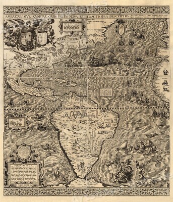
$5.95 Shipping Condition: New Location: Las Vegas, United States The New World 1562 Size: 20" x 24" 51 cm x 61 cm) x Also Available in 24" x 28" from our eBay Store This is a great Classic Map originally ... morePublished circa 1562. This Map shows the America's as it was known in the 1500's. Includes texts in cartouche. Statements of dedication, coats-of-arms, ill. of allegorical f igure"Victoria" And ill. of sailing ships at sea and imaginary marine creatures. The wording on the map reads: Americae sive qvartae orbis partis nova et exactissima descriptio/ avtore Diego Gvtiero Philippi Regis Hisp. etc. Cosmographo; Hiero. Cock excvde 1562; Hieronymus Cock excude cum gratia et priuilegio 1562" This poster. Which evokes the vivid images of a simpler time, is a custom reproduction printed on 68lb Heavyweight Enhanced Matte Art Paper. This Historic Art Print is suitable for framing. Mounting or direct display on any wall! 000 Artscape Galleries/ Posters Past More Prints and Posters Available from our eBay Store! Shipping price includes delivery confirmation. We combine shipping for multiple purchases- add $1.00 for each additional poster. All posters are professionally packaged to ensure that they arrive safely and undamaged: Your poster is first rolled and inserted into a plastic sleeve before being placed into a Heavy-Duty mailing tube for delivery. We stand behind the quality of every poster. If you are not satisfied with your purchase. Please contact us within 30 days to arrange for either an exchange or a full refund. gsrx_vers_468(GS 6.4(468)
Buy It Now
$5.00 Shipping Location: Canada DATE OF ISSUE: 1928.
Buy It Now
$20.00 Shipping Location: Highland Park, United States
Buy It Now
$222.80 Shipping Location: Perry, United States Gold Foil Vintage print Fame is in very good condition - no separation or chips, nicks etc.This is a vintage reproduction of an antique mapProfessionally ... moreframed 341/4 x 25 3/4 frame sizeInside size 27 7/8 x 19 1/4see photos for complete description
Buy It Now
Free Shipping Location: Training Battalian S.O, India BEAUTIFUL BRASS NAUTICAL WORLD GLOBE. GRIFITH ASTRO NAUTICAL GLOBE. ANTIQUE WORLD GLOBE WITH STAND. TABLE TOP WORLD GLOBE. FROM BOTTOM TO TOP OF GLOBE. ... moreSTAND MADE OF SOLID ALUMINUM IN ANTIQUE FINISH. A NICE GIFT TO PRESENT OR USE AS A GREAT WORKING COLLECTIBLE.
Buy It Now
$6.90 Shipping Location: Audubon, United States It is an old, original map that was rescued from an unusable atlas. You will receive the exact antique map in the photos. Condition is very good, age ... moreconsidered. This map would look great displayed in any room.
Buy It Now
$8.00 Shipping Location: Fishers, United States Educational Productions LTD map of Earth's Annual Revolution printed in England (1967). It was actually used in a classroom so the edges are not perfect ... morebut the art itself is very nice and vivid. 29x almost 40".
Buy It Now
$8.70 Shipping Location: Fredonia, United States Keep checking back.
Buy It Now
$5.95 Shipping Condition: New Location: Las Vegas, United States It was the first map, printed or manuscript, to depict clearly a separate Western Hemisphere, with the Pacific as a separate ocean. Each of our prints ... moreare custom reproductions printed on 68lb Heavyweight Enhanced Matte Art Paper.
Buy It Now
$6.90 Shipping Location: Jasper, United States Known for being one of the oldest and most respected publishing houses in Germany, the Bibliographisches Institut specialized in authoritative reference ... moreworks. The map's condition is as shown in the pictures.
Buy It Now
$6.90 Shipping Location: Audubon, United States You will receive the exact antique map in the photos. Condition is very good, age considered. This map would look great displayed in any room.
Buy It Now
$4.95 Shipping Location: Willow Grove, United States This is an ORIGINAL map page showing the Western Hemisphere of the World as well as other information which was taken from an 1890 atlas.
Buy It Now
$4.99 Shipping Location: Las Vegas, United States Vintage CS Hammond Portfolio Book of Maps of The World - Pull out wall maps - 8 total 38"x25" - Pre-owned - some wear -
Buy It Now
$5.00 Shipping Location: Canada DATE OF ISSUE: 1937. ORIGIN OF THE MAP: "Der Neue Brockhaus" (Atlas), published by F. A. Brockhaus, Leipzig, Germany.
Buy It Now
$5.00 Shipping Location: Canada DATE OF ISSUE: 1937. ORIGIN OF THE MAP: "Der Neue Brockhaus" (Atlas), published by F. A. Brockhaus, Leipzig, Germany.
Buy It Now
Free Shipping Location: Schertz, United States This Map was removed from an 1878 Mitchell's School Atlas and is in very good condition. The map is not " new " or in " new " condition, it was printed ... morein 1878. The map is not dated. Including Hundreds of RareCivil War.
Buy It Now
$222.80 Shipping Location: East Mc Keesport, United States The map shows both sides of the globe. This engraved copper mounted world map is in very good condition. The copper engraving is beautiful. Very clean. ... moreNo dents or major flaws. The wood backing is solid.
Buy It Now
$5.00 Shipping Location: Canada DATE OF ISSUE: 1926. ORIGIN OF THE MAP: Ernst Friedrich's "Minerva Atlas / Handatlas fuer das Deutsche Volk", published in Leipzig, Germany by Verlag ... moreder Literaturwerke "Minerva", R. Max Lippold.
Buy It Now
$6.90 Shipping Location: Jasper, United States Known for being one of the oldest and most respected publishing houses in Germany, the Bibliographisches Institut specialized in authoritative reference ... moreworks. The map's condition is as shown in the pictures.
Buy It Now
$22.85 Shipping Location: Pine, United States We do our best to describe each item in detail and provide pictures that feature any defects or issues that we are aware of. After this, the sale is final. ... moreTHIS IS A BUY-IT-NOW ITEM.
Buy It Now
Free Shipping Location: Colorado Springs, United States This collection includes 11 vintage maps of the world from the year 1962. Each map is a unique representation of the world during that time period, showcasing ... moregeographical features and political boundaries. The maps are in good condition and would make a great addition to any collection of antique maps. They provide a glimpse into the past and the changing nature of the world. The maps are perfect for display in a home, office, or classroom setting.
Buy It Now
$6.90 Shipping Location: Jasper, United States Known for being one of the oldest and most respected publishing houses in Germany, the Bibliographisches Institut specialized in authoritative reference ... moreworks. I believe they deserve to be appreciated by fellow collectors rather than gathering dust in storage.
Buy It Now
$13.73 Shipping Location: MANCHESTER, United Kingdom This map is from General Atlas of The World by Sidney Hall, William Hughes etc, published by Adam & Charles Black, Edinburgh, 1854. This interesting map ... moreis an original antique which is over 165 years old.
Buy It Now
$89.95 Shipping Location: United States .CANVASS TYPE MATERIAL. SHOWS HANDLING/AGE WEAR.
Buy It Now
$5.00 Shipping Location: Canada DATE OF ISSUE: 1938. ORIGIN OF THE MAP: "Der Neue Brockhaus" (Atlas), published by F. A. Brockhaus, Leipzig, Germany.
Buy It Now
$4.99 Shipping Location: Greenup, United States This vintage WWII nautical chart is titled"JAPAN. SOUTHERN ISLANDS, OGASAWARA GUNTO, HAHA SHIMA AND APPROACHES. Publication information: WASHINGTON. ... moreDC, published 1944. Dimensions: 28 X 41(71cm X 103cm) Chart# 6065 This US NAVY chart is in excellent condition. It has never been used for navigation and is clean and smooth. There is a US Navy stamp in faint pink at extreme edge of the paper at lower left. Beyond the black border of the image. It gives final correction date. Please look at all photos carefully, as most details and flaws are visible in them. If you click on an individual picture, you should be able to zoom in and see the areas close-up. International buyers, please read shipping details before you make payment. I am happy to answer any questions. If you intend to purchase more than one chart from me, please add your items to your cart before you checkout and make final payment.
Buy It Now
$12.99 Shipping Location: Fayetteville, United States Up for sale is a copy of We will work with you to resolve any issue. Great buy!
Buy It Now
$5.00 Shipping Location: Canada DATE OF ISSUE: 1930.
Buy It Now
$6.90 Shipping Location: Jasper, United States Known for being one of the oldest and most respected publishing houses in Germany, the Bibliographisches Institut specialized in authoritative reference ... moreworks. I believe they deserve to be appreciated by fellow collectors rather than gathering dust in storage.
Buy It Now
$39.99 Shipping Location: Fort Lauderdale, United States ( amongst other changes ). ( see photos ). This World Globe was made in the USA.
Buy It Now
$21.16 Shipping Location: SUTTON COLDFIELD, United Kingdom MAGNIFICENT LARGE HARDBACK MAP. ABOUT THIS MAP. CONDITION: Excellent condition perfectly preserved in the archives.
Buy It Now
$5.95 Shipping Condition: New Location: Las Vegas, United States Novissima Totius Terrarum Orbis Tabula. Each of our prints are custom reproductions printed on 68lb Heavyweight Enhanced Matte Art Paper. These Historic ... moreArt Prints are suitable for framing, mounting or direct display on any wall!
Buy It Now
$5.95 Shipping Condition: New Location: Las Vegas, United States Of allegorical f igure "Victoria", and ill. Cosmographo ; Hiero. Cock excvde 1562 ; Hieronymus Cock excude cum gratia et priuilegio 1562". Year: 1562. ... more“Vibrant and bright! Pic does not do it justice.looks amazing!”.
Buy It Now
$5.00 Shipping Location: Canada DATE OF ISSUE: Ca. 1935.
Buy It Now
$6.90 Shipping Location: Jasper, United States Known for being one of the oldest and most respected publishing houses in Germany, the Bibliographisches Institut specialized in authoritative reference ... moreworks. The map's condition is as shown in the pictures.
Buy It Now
$5.95 Shipping Condition: New Location: Las Vegas, United States It shows the world as it was known in the mid 1500's. Year: 1565. “Vibrant and bright! Pic does not do it justice.looks amazing!”. Beautiful map! Each ... moreof our prints are custom reproductions printed on 68lb Heavyweight Enhanced Matte Art Paper.
Buy It Now
$6.90 Shipping Location: Jasper, United States Known for being one of the oldest and most respected publishing houses in Germany, the Bibliographisches Institut specialized in authoritative reference ... moreworks. The map's condition is as shown in the pictures.
Buy It Now
Free Shipping Location: Augusta, United States "AN AUTHENTIC ORIGINAL MAP NOT A REPRODUCTION".
Buy It Now
$5.95 Shipping Condition: New Location: Las Vegas, United States Nova Totius Terrarum Orbis Tabula. Each of our prints are custom reproductions printed on 68lb Heavyweight Enhanced Matte Art Paper. These Historic Art ... morePrints are suitable for framing, mounting or direct display on any wall!
Buy It Now
$6.00 Shipping Location: Corte Madera, United States Measures 23 1/2 by 35 inches unfolded, and is very striking!
Buy It Now
$5.95 Shipping Condition: New Location: Las Vegas, United States Each of our prints are custom reproductions printed on 68lb Heavyweight Enhanced Matte Art Paper. These Historic Art Prints are suitable for framing, ... moremounting or direct display on any wall! “Vibrant and bright!
Buy It Now
$5.95 Shipping Condition: New Location: Las Vegas, United States Typus Orbis Terrarum. This early 17th Century World Map shows the Old World and the New as it was known in 1608. “Vibrant and bright! Pic does not do ... moreit justice.looks amazing!”. Each of our prints are custom reproductions printed on 68lb Heavyweight Enhanced Matte Art Paper.
$4.85 Shipping Location: Taylor, United States Great collectible great for framing map has been folded looks like tape on the back, where it is folded, some minor discoloration fading I will be mailing ... morethe map folded.
Buy It Now
$6.87 Shipping Location: HORNCASTLE, United Kingdom
Buy It Now
$5.95 Shipping Condition: New Location: Las Vegas, United States Year: 1695. Each of our prints are custom reproductions printed on 68lb Heavyweight Enhanced Matte Art Paper. These Historic Art Prints are suitable for ... moreframing, mounting or direct display on any wall!
Buy It Now
$6.90 Shipping Location: Jasper, United States Known for being one of the oldest and most respected publishing houses in Germany, the Bibliographisches Institut specialized in authoritative reference ... moreworks. I believe they deserve to be appreciated by fellow collectors rather than gathering dust in storage.
Buy It Now
Free Shipping Location: Lehi, United States This product is a vintage reproduction of a world map by Henricus Hondius, framed in a 12x9 inch frame. The map is designed to be used as a mirror, but ... morehas one scratch. The map shows the entire world and is categorized under World Maps, Maps, Atlases & Globes, and Antiques.
Buy It Now
$5.00 Shipping Location: Canada DATE OF ISSUE: 1926.
Buy It Now
$6.90 Shipping Location: Jasper, United States I believe they deserve to be appreciated by fellow collectors rather than gathering dust in storage. Stay tuned!". Known for being one of the oldest and ... moremost respected publishing houses in Germany, the Bibliographisches Institut specialized in authoritative reference works.
Buy It Now
$28.00 Shipping Location: Portugal Very rare World Map from Portuguese School - 1973. This is an old school map and there are normal signs of use. Map features It is a great item for collectors ... moreand map enthusiasts. Material: Printed on sailcloth/Canvas (Fabric).
Buy It Now
$59.85 Shipping Location: Canfield, United States Vtg Nystrom Map Symbols& Geographic Concepts 46Cardboard 19”X24” Pieces Complete. Condition is used . Comes in original metal case. In very good condition. ... moreHard to find in COMPLETE SET.
|
|
|
In
|
AFRICA: Africa and World population; Birth rate; Death rate 1973 vintage map
Africa and World population; Birth rate; Death rate Vintage colour map. 1973 Title of map: Africa and World population; Birth rate; Death rate' The image below shows an enlarged cross section from the centre of the map to show the level of printed detail: DATE PRINTED: 1973 IMAGE SIZE: Approx 32.0 x 24.0cm. 12.5 x 9.25 inches(Large) ARTIST/CARTOGRAPHER/ENGRAVER: Unsigned PROVENANCE: The Atlas of Africa" Editions jeune afrique. Please note that virtually all antique and vintage maps and prints have been extracted from books. Atlases or newspapers. TYPE: Vintage colour map VERSO: There are images and/or text printed on the reverse side of the picture. In some cases this may be visible on the picture itself(please check the scan prior to your purchase) or around the margin of the picture CONDITION: Good; suitable for framing. However. ... morePlease note: Verso text quite apparent. Please check the scan for any blemishes prior to making your purchase. Virtually all antiquarian maps and prints are subject to some normal aging due to use and time which is not obtrusive unless otherwise stated. I offer a no questions asked return policy- see below. AUTHENTICITY: This is an authentic historic print. Published at the date stated above. I do not offer reproductions. It is not a modern copy. The term'original' when applied to a print means that it was printed at the first or original date of publication; it does not imply that the item is unique. Print' means any image created by applying an inked block to paper or card under pressure by any method including wood engraving, steel engraving, copperplate, wood cut and lithography. REMARKS: FRANCE: Gravures et Cartes anciennes. DEUTSCHLAND: Alte Lankarten und Stadt ansichten. ITALIA: Stampe& Mappe antiche. ESPAÑA: Mapas antiquos y impresiones antiguas. E and OE. Force Majeure. English law shall apply. RETURNS POLICY: I offer a no questions returns policy. All I ask is that you pay return shipping and mail back to me in original condition. Suitably packed
|
|
|
VINTAGE NAUTICAL WORLD MAP GLOBE CEILING LIGHT FIXTURE CHANDELIER MID CENTURY
Hello all.heres a GREAT 1950's-60's ish nautical theme ceiling light I know someones going to dig. Its in fantastic condition with no chips/cracks etc. and measures about 15" across the world map glass shade. And sits about 9.5" down from the ceiling. It has a 3 bulb socket and a nicely detailed fluted brass foot, and a great clear glass ships wheel finnial. Great, hard to find fixture in fantastic shape! Thanks for looking. RcmdId ViewItemDescV4,RlogId p4%60bo7%60jtb9%3Fv%7F.rpn33%3E-13d32018ec8-0x101-
|
|
|
Ice Bucket-Insulated-Leather-Vintage-Old world Map Scene..Very Nice!!!
Nice Vintage. Leather,insulated, ice bucket.It has the old world map scene on the front.It has gold trim around the edges of the top and bottom.It would look very nice in a bar setting,or for everyday use.It measures approx 11 1/2" tall& approx 25" round. Please feel free to contact me with any questions.I take pride in packing all of my items.Thanks for your interest.
|
|
|
Antique Vintage Old Large 50 x 33 1950-1960 's Mercator's Projection World Map
This is a very nice large late 1950's to 1960's World Map. It is Mercator's Projecton Map that is quite large and very vivid in color. The map is 55 inches x 33 inches which is quite large when it comes to maps. It was very hard to get a picture of the whole map due to it's size. The map is in good condition and folds up well. Would look great with a corregated backing and would be a nice wall hanging. Thanks for looking.
|
|
|
Urban Outfitters Small Vintage World Atlas Globe Map With Wooden Holder
Urban outfitters small world globe. About hand sized. With small wooden circle holder for item. Is new but without packaging. Please note the globe isnt exact, just for show. never the less, a lovely ornament! xxxx
|
|
|
vintage Italy ZODIAC wood wall plaque picture World MAP ASTROLOGY ASTRONOMY
vintage Italy ZODIAC wood wall plaque picture World MAP ASTROLOGY ASTRONOMY Very interesting plaque measures 8 1/2/ x 6/1/4" and features world maps surrounded by colorful pictorial signs of the zodiac. Shows wear and nice patina. Consist ant with it's very vintage condition, sold as you see it here. The back at one time appeared to have a hook but the hook is no longer there. Still has original"import from Italy" sticker on back. Really neat piece and and a fantastic partner to the"Olde World" desk stand globes and bookends! Payment is due within 7 days of close of auction. Item will be shipped within three days of payment. inkfrog terapeak.
|
|
|
RAND MCNALLY WORLD ATLAS BOOK MAP VINTAGE OLD PICTORIAL EDITION 1934 GAZETTEER
The binding needs some work on the lower half. Copyright 1934. 1935, so in pretty good shape considering. There is some pencil writing on the inside cover, but should clean up easily. 64 pages long, and chock full of pictures and maps. S& H is $2.00 to the lower 48. I ship worldwide. So please ask for a quote. I accept Paypal and any kind of a check. Check will have to clear before I ship. I will combine shipping. f04.RcmdId ViewItemDescV4,RlogId p4%60bo7%60jtb9%3Fuk.rp*6%3D%3F%3Ef04-13d3a8a7c70-0x100-
|
|
|
Vintage/ Antique Putnam's Handy Map Book 1920-1921 All Countries of the World
Vintage/ Antique Putnam's Handy Map Book 1920-1921 All Countries of the World. Maps are in color. Front and back covers are bent down the middle. See pictures for overall condition. 319 pages. Feel free to ask any questions.
|
|
|
WORLD MAP REVOLVING GLOBE COLLECTION 4 VINTAGE VERY GOOD
WORLD MAP REVOLVING GLOBE COLLECTION 4 VINTAGE VERY GOOD INTERNATIONAL ALSO INSURED IN THE SHIPPING PRICE! IF YOU REQUEST DELIVERY. I will deliver Dallas/fort Worth, Denton(within 100 miles) for $60, Austin, Houston for $250, PERSONALLY DELIVERED TO YOUR DOOR.
|
|
|
VINTAGE REPLOGLE 12 INCH WORLD CLASSIC SERIES/RAISED MAP AND ON A HARDWOOD STAND
THIS IS A GLOBE ON HARDWOOD STAND THAT HAS TRAVELLED W/ MYSELF AND FAMILY.A.GREAT DEAL. I HAVE TRIED FO SHOW THE BEST PHOTOS I CAN. THE LAST 2PHOTOS SHOW A LITTLE WEARING THRU THE YEARS THIS GLOBE HAS THE TIME ZONE MOVEABLE DISK ON TOP.THE RAISED MAP MAKES IT SO MUCH MORE INTERESTING. THERE IS NO.WEAR AND TEAR THAT WOULD OBSTRUCT YOUR VIEWS OF THE CLASSIC WORLD. THE SEAMS ARE TIGHT AND NOT LIFTED ANYWHERE I CAN SEE. FROM MY SMOKEFREE HOME. THANKS FOR LOOKING. SHIPPING TO ZONES 6-8 WILL BE A BIT MORE SO PLEASE WAIT FOR INVOICE! Posted with
|
|
|
Nystrom First Globe 16 Inch Map No. 31-47 Vintage Raised Texture Earth World
Nystrom First Globe 16 Inch Map No. 31-47 Vintage Raised Texture Earth World For auction is a vintage 16" Nystrom world globe. This is the type with raised textured surface showing all of Earth's mountain ranges. The globe swivels 360 degrees on it's axis and also pivots 360 degrees from North to South so that all points on the globe can be seen from one perpective. This comes with a steel Nystrom base that is in exellent condition. It functions perfectly and other than some light marks the globe itself is in very good condition. Contact us: If you have any questions about this item or any of my other listings please feel free to email through the site at any time or text/call me personally on my cell at(248) 924-0554(Between 7 AM and 11 PM Eastern) Combined Shipping: Most of the time I can combine shipping if items are purchased ... morefrom multiple listings or auctions. If you would like a combined shipping quote please email me a list of the items that you would like to purchase. The quantity of each and your city, state and zip code( and country if applicable) I will try and get back you as quickly as possible. Returns: In the unfortunate event that the item you purchased needs to be returned please send me an email so that we can make the arrangements. I accept returns on most of my items and when available can offer replacements/exchanges as well.
|
|
|
1950's VINTAGE GERMAN BROWN BAKELITE STAND TERRESTRIAL POLITICAL WORLD MAP GLOBE
1950's VINTAGE GERMAN BROWN BAKELITE STAND TERRESTRIAL POLITICAL WORLD MAP GLOBE By prof.dr Arthur Krause! M 1: 106 000 000; diameter: 12cm Printed by: VEB Hermann Haack Werk. Leipzig Marked by Producer! height: 7 1/4" base diameter: 4" globe diameter: 4 1/2" CONDITION: excellent vintage condition/ without chips or cracks Powered by The free listing tool. List your items fast and easy and manage your active items. On Mar-03-13 at 16:40:30 PST. Seller added the following information:
|
|
|
ANTIQUE VINTAGE REPLOGLE 12" REFERENCE WORLD GLOBE MAP SCHOOL TEACHER TOOL
Here is an old world globe. It is a 12" size. I see no date on it but looks older. Has a tin base. The base appears to be missing a drawer or something. Cannot be for sure. In good condition. Please see all my auctions. Thank you.
|
|
|
vintage 1950s HAMMOND'S GLOBAL STRATEGY MAPS World Map poster
Normal 0 false false false MicrosoftInternetExplorer4 From Hammond Maps. Vintage 1950s. Full color world ma p"Containing Gazetteer and Map of the World with 4 Global View Maps showing lands bofdering the Atlantic Ocean. Pacific Ocean, Ind ian Ocean and Top of the World. Map is in Very Good condition with pinholes in the cor ners. A couple of p ieces of old cello tape. Some short tears at creases. Combined shipping discounts are available. Super low opening bid. Super low reserve. Winning bidder to pay $4.99 towards priority mail shipping or $2.99 towards media mail. Thanks for bidding!
|
|
|
Vintage Auto Road Map NYC NEW YORK WORLD'S FAIR Tidewater Oil Company 1964-65
Hello To All. VINTAGE TIDEWATER World's Fair Map. Measures 26 3/4" X 34 1/4" 1) Piece Of Tape, Light Staining and Front and Back Cover Wear, Overall In Good Condition, Thank You, Have Fun and Happy Hunting!
|
|
|
Vintage Tin Container World Map Made in Japan Great Desk Accessory
Vintage Tin Container World Map Made in Japan Great Desk Accessory Or for anyone who loves maps 5' Tall x 7" x 5" Very Excellent Vintage Condition No Rust MY PRICES ARE LOWER THAN MOST BUT THE QUALITY IS NOT I DO NOT use stock photos. The pictures you see are of the item(s) I am selling. Your bid indicates your agreement to pay. Highest bidder pays USPS shipping. Your purchase will be packaged with care and will survive typical rough handling. Although I aim to assure safety with a well packaged parcel. Once it is in transit, it is out of my control and thus, I cannot accept responsibility for the very rare occurrence of damage or loss by USPS. Please read my feedback If Shipping Internationally. Alaska,Hawaii, or PR please Contact Me for Shipping Cost BEFORE Bidding Import duties. Taxes, and charges are not included in the ... moreitem price or shipping cost. I do not make money on shipping I ship on the first business day after payment confirmation Please make payment within 3 business days Contact me with any questions or additional photos if needed Happy Bidding! If you have time. Please take a look at my other items up for bid. Click Here to View: other items! Be sure to add me to your: favorites list!
|
|
|
OLD WORLD MAP VINTAGE ICE BUCKET WITH EAGLE ON TOP AND WOODEN HANDLES BARWARE
UP FOR AUCTION IS THIS OLD WORLD MAP VINTAGE ICE BUCKET WITH EAGLE ON TOP AND WOODEN HANDLES. IT MEASURES APPROX. 8 1/2" TALL NOT INCLUDING EAGLE AND 7 1/4" ACROSS. THIS ICE BUCKET IS IN USED CONDITION AND THE WOOD HAS SOME WEAR AND WHAT LOOKS LIKE A COUPLE OF PAINT MARKS NEAR THE BOTTOM ALSO HAS DENTS AND SCRAPES ON THE INSIDE BOTTOM WHICH YOU WOULDNT SEE ONCE IT IS FILLED WITH ICE. OVERALL A GREAT PIECE FOR ENTERTAINING. PLEASE DON'T HESITATE TO ASK ANY QUESTIONS BEFORE BIDDING THANK YOU:0)
|
|
|
Quebec New Brunswick Nova Scotia - Original Vintage 1900 Antique World Atlas Map
These beautiful colored maps come from the original 1900 Tunison's Atlas of the World 113 years old! 100% Original and Authentic. Gorgeous maps featuring the Canadian Provinces of Q uebec. New Brunswick, and Nova Scoti a with a with an incredible amount of detail. Maps show counties. Cities, towns, railroads, rivers, creeks, islands, lakes and topography in great detail. Maps measures 14" X 11" Please see pictures for condition detail. It is ready to frame and would look great on the wall of your office or study. I g ave a couple of these as Christmas presents and they were a big hit! Will ship rolled in a tube. Free Sh ipping within the U ni ted States. I have the entire World Atlas available and as it has fallen apart I will be separating it and selling the maps individually so they can be enjoyed. If you are interested in ... moreany particular States or Countries please let me know.
|
|
|
WORLD MAP OF FOOD PLANTS NUTS & CEREALS VINTAGE PRINT 1924 MOUNTED
WORLD MAP OF FOOD PLANTS NUTS& CEREALS VINTAGE PRINT 1924 MOUNTED SELLING A LIFETIME COLLECTION OF OLD BOOKS AND MAPS MOUNTED PRINT PRINT IS 88 YEARS OLD WORLD MAP OF THE FOOD PLANTS OF MANKIND FRUITS NUTS& CEREALS Original print published in 1924 Enlarge scan to see content and quality AUTHENTICITY: This is an authentic historic print. Published at the date stated above. I do not offer reproductions. It is not a modern copy. The term'original' when applied to a print means that it was printed at the first or original date of publication; it does not imply that the item is unique. Print' means any image created by applying an inked block to paper or card under pressure by any method including wood engraving, steel engraving, copperplate, wood cut and lithography. Condition Print was published in 1924 7.5" x 5" ... moreClean and Bright Print is mounted A Highly collectable rare print. I Ship Worldwide UK Postage £1.95(secure& protective packing) Other European Countries £2.95 Airmail USA £3.95 Airmail See more of my collection at http:stores.ebay.co.uk/peters-rarebooks Bid with confidence 100% money back guarantee if item not as described
|
|
|
World Map vintage Poster Art Print 24x36 PA31841
World Map vintage Poster Art Print 24x36 PA31841 You are bidding on a New. Never before opened, rolled. Vintage World Map poster. Measures 24x36 inches. approx) If you have any questions please contact us. We offer combined shipping on 2 or more items. Posterized accepts only PayPal transactions. Payment must be received within 7 days of the end of the listing. We will combine your shipping costs when ordering more than 1 poster. You will be charged the initial shipping cost of $4.00 plus. For each additional poster add $2.00. ex.2 posters $6.00 total shipping) If you do not combine your order. Shipping refund will only be given upon request. All orders from Ohio should add 7% sales tax to their order. Posterized ships all posters using USPS First Class Mail. Once your payment clears your order will typically ship in 1-2 business days. When ... moreordering 2 or more posters. Make sure to combine shipping cost. You pay only the intial $4.00 shipping for the first poster and $2.00 for each additional poster. The more posters you buy. The cheaper they become. Combined shipping discounts are only applied when shipping to the same address. All payments should be made with in 7 days. After that we will start an unpaid claim with ebay's resolution center. Your order will typically ship within 1 business day of your payment clearing. If your are unsatisfied with your order. Returns are accepted with prior authorization. Please contact us with any issues you may have so that we can resolve them. Remember to save on shipping cost when ordering 2 or more posters by combining the order and paying only an additional $2.00 per poster above the original(1st poster)$4.00 shipping fee. Posterized is a company that is dedicated to fulfilling all of your poster needs. We enjoy decorating our walls with posters just as much as you do. We make every effort to keep up with the latest posters being offered with the newest designs. If there is a poster that we don't have. Let us know and we will make every effort to obtain it for you.
|
|
|
Vintage Map of world by Johannes Kepler LARGE archival Fine Art print 24" x 40"
Print reproduction of word map created by Johannes Kepler. Johannes Kepler was a German mathematician. Astronomer and astrologer. He was key figure in astronomy. This word map was published in"Johannes Kepler's book" Created around 1572- highest quality archival reproduction on museum class paper. Size: 24" x 40" 60cm x 100cm) Paper: Hahnemuhle best quality museum class paper with texture. Ink: Ultrachrome ink( that will last up to 80 years indoors) Shipping: Print is shipped in a strong tube for secure shipping and it will be shipped as a priority mail for fast delivery» Items usually ship within 2-3 days from date of completed payment» Delivery takes around 1 Week- Frame is not included and is just to show how great it looks framed!
|
|
|
Fantastic Vintage Cram's Political/Physical Map of US & World Pull Down Map
Fantastic Vintage Cram's Political/Physical Map of US& World Pull Down Map This auction is for a beautiful school pull down map of the US and the world. it is made by Cram's and is undated. Looks to be from the 1990's, Map is in excellent condition, very clean and colors are bright. there is a minor scuff along the side and a 2" tear through Indiana that if taped from underside will hide very well. the world map could use a pole to keep from rolling up when opened(both metal and wood dowel rods are available at any home improvement store for little money) there is also a ripple of wrinkles through the center of the world map that I literally had to be looking at the map while on the floor with the map flat on the floor at eye level to see. US Map measures 64" wide 69" tall, world map 64"x 47" Please ... moresee all pictures. PLEASE NOTE. I CANNOT SHIP INTERNATIONALLY(OTHER THAN CANADA) DUE TO SIZE REGULATIONS ON THE LENGTH OF THIS MAP Payment is appreciated within 5 days. I am happy to wait a reasonable amount of time if you are hoping to combine future purchases to save money on shipping as long as I am aware of your intention. Please contact me with any questions or concerns. I try to ship Monday through Friday but sometimes Mondays are tough. Shipping is based on weight and location and is not always accurate to the penny but if there is a gross difference in your favor. I will refund the difference. Items that are fragile and/or have a high value may include an additional $2 for insurance. I have noticed in the past that the ebay shipping calculator does not always agree with the postal calculator on international shipping. Once in awhile I get a surprise at the post office where the shipping is significantly higher than what ebay has quoted. Depending on the value of the shipment, I may request payment of the difference or offer to cancel the transaction. I love flat rate priority boxes and will stuff them full to save money every chance I get! I do accept returns within 7 da
|
|
|
Book Atlas World Russian Soviet Old Vintage Map
PRODUCT INFORMATION Old soviet time russian atlas of the World in Russian. Soft cover. Published in the 1980th in the Soviet Union by publishing house ministry of geology in Moscow. Book was used, but condition is good. Size is 120 x 180 mm(4.8" x 7.2" and 64 pages PAYMENT PAYMENT IN USA. I accept payments: PayPal, MO and Personal Checks are welcome. SHIPPING/HANDING Buyer pays fixed $9 shipping costs for any country. This item will be shipped to you from Europe(Ukraine) via airmail immediately after payment is fully received and will be arriving within 10-14 business days to your destination. RETURN POLICY Your satisfaction is always my top concern. If you have any issue regarding your transaction. Please email me as soon as possible before leaving negative feedback or any other action. I do what I can to make things right if anything ... morein a transaction goes wrong. Please. Do not bidding if you are not going to buy. All pictures are actual. You receive what you see. I will combine multiple orders to ship together as one order to reduce your shipping charges. If you have any questions to ask me and I will get back to you as soon as possible. Good Luck! Powered by The free listing tool. List your items fast and easy and manage your active items.
|
|
|
Vintage Art Deco 1939-40 New York World's Fair Map Theme Cloth Apron
HERE IS A REALLY NEAT VINTAGE ART DECO DESIGN CLOTH APRON FROM THE 1939-40 NEW YORK WORLD FAIR.THIS APRON FEATURES A MAP THEME OF THE FAIR. WITH A WONDERFUL DECO TRYLON& PERISPHERE EDGE AND TIES.SOME OF THE SITES INCLUDE"TRANSPORTATION ZONE"PRODUCTION& DISTRIBUTION ZONE"BRIDGE OF WINGS"EMPIRE STATE BRIDGE"LAGOON OF NATIONS" AND MORE.IT MEASURES APPROX. 43" LONG x 28" WIDE(NOT INCLUDING THE TIES)CONDITION IS GOOD WITH NO HOLES/RIPS.SOME FADING(PICS ARE BRIGHTER THAN ACTUAL COLOR)SOME EDGE FRAYING.A FEW MINOR STAINS.THIS WILL BE A GREAT ADDITION TO YOUR 39 N.Y.W.F. COLLECTION!THE WINNING BIDDER PAYS ACTUAL SHIPPING COST UNLESS OTHERWISE STATED.WINNING BIDDER MUST MAKE PAYMENT VIA PAYPAL WITHIN 5 DAYS OF END OF AUCTION.I'M ALWAYS HAPPY TO COMBINE SHIPPING TO SAVE YOU $MONEY$.ITEMS SHIP SAME/NEXT ... moreDAY AT MOST TIMES UPON RECEIPT OF YOUR PAYMENT.PLEASE FEEL FREE TO ASK ANY QUESTIONS BEFORE BIDDING.YOUR PROMPT FEEDBACK ALWAYS GETS MINE.THANKS FOR LOOKING!Check out my!Be sure to add me to your!
|
|
|
VINTAGE ITALIAN WORLD MAP GLOBE BOOK END
VINTAGE ITALIAN WORLD MAP GLOBE BOOK END ONLY ONE MEASURE APPROX# 3.75 X 5.25 X 5.5 TALL, P.L.Z TAKE LOOK AT PICTURES BEFORE BIDDING
|
|
|
Vintage Weber Peerless 12" World Map Globe Metal Stand
Vintage World Map Globe on Metal Stand. 12" Weber Peerless From an esta te sale. No copyright date. Normal signs o f age and use. Ni ce vintage condition.
|
|
|
CARIBBEAN ISLANDS authentic World War 2 Era Vintage Map genuine made in 1945
West Indies Authentic 68-Year-Old Vintage Map Made During World War II FREE SHIPPING ANYWHERE IN THE USA! Printed in 1945. This is a beautiful, 68-year-old map of the island nations of the Caribbean Sea. It measures about 10 3/4 by 14 1/4 inches(about 27 by 36 cm. and is in Fine condition. The map contains a wealth of detail including latitude and longitude, topographical features, territories, cities, towns and villages, routes of old railways and more. An index is printed in the margin. This is a guaranteed genuine vintage map! Ideal for genealogy or historical research. This map was printed on a single sheet of stock and bound whole in an antique book. There are no folds or creases, and the paper is clean and not brittle. A similar map of Puerto Rico on a larger scale is printed on the reverse. Highly suitable for framing, this map would ... morelook great in your office, library, den or study. It is similar to many of the maps sold in expensive mail-order catalogues and department stores, with one important difference: this is an actual antique. NOT a modern reproduction. A great investment. This map is certain to appreciate in value over time. Please ask all questions before making your purchase. FREE SHIPPING anywhere in the USA by USPS First Class Mail. Priority and Express services also available. Shipped rolled in a sturdy tube. We ship worldwide! cwag45
|
|
|
Nestle Nescafe Vintage Glass Globe World Map Mugs Cups
Nestle Nescafe Vintage Glass Globe World Map Mug Cup Mint Condition Posted with
|
|
|
Vintage Nescafe World Map Sugar Bowl With Lid & Creamer Set
Nescafe imprinted on bottom Sugar bowl with lid and creamer Very nice no cracks chips or flea bites noticed They are heavy glass See pics for details Posted with eBay Mobile Posted with
|
|
|
Vintage Nescafe World Map Mugs Qty 4
Set of 4 glass mugs Nescafe imprinted on bottom 1 mug has a small chip on rim by handle pictured Another has very small flea bite near handle All still totally usable They are heavy glass See pics for details Posted with
|
|
|
Vintage Wall Map of The Political & Physical World 1975 National Geographic
Vintage Wall Map of The Political& Physical World 1975 National Geographic Good condition no rips check out pictures and thanks for stopping by romans51. Posted with
|
|
|
cr 1965 WORLD-WIDE ATLAS BY C.S. HAMMOND / VINTAGE MAP BOOK
THIS IS A USED BOOK THAT DOES SHOW SOME NORMAL AGE AND WEAR. THERE IS A CREASE AND WHITE SPOT ON THE COVER THAT YOU CAN SEE IN THE PICTURES. MEASURES APPROXIMATELY; 7" X 10" FREE US SHIPPING ONLY! INTERNATIONAL BUYERS PLEASE USE SHIPPING CALCULATOR PROVIDED. THANKS FOR LOOKING AND HAVE A GREAT DAY!
|
|
|
1970 Large 2 Sided Vintage Map THE WORLD NATIONAL GEOGRAPHIC 42" X 29" PRETTY!
1970 Large 2 Sided Vintage Map THE WORLD NATIONAL GEOGRAPHIC 42" X 29" PRETTY! The opposite side is" how man pollutes his world" Very good condition Can be matted framed and mounted for you home Posted with
|
|
|
Set of 2 Vintage Nestle Etched Glass World Globe Map Coffee Mug
Only USA BUYERS Set of 2 Vintage Nestle Etched Glass World in MINT condition. Comes from a smoke free home. I think my mother-in-law used this set once. No chips or cracks. If you have any other questions. Feel free to ask.
|
|
|
VINTAGE DETAILED MAP NO. 1308 - AROUND THE WORLD A NEW MAP BY H.E.C. ROBINSON
Up for sale is a vintage detailed Robinson's Map of The World Mercators Projection Map No. 1308 by H. E. C. Robinson Pty. Ltd. The map shows some wear in the original folds and has a couple of small holes in the corner folds. The map measures approximately 40" x 30"
|
|
|
VINTAGE RAND MCNALLY POCKET MAP ASIA EUROPE WORLD WAR II ERA GOOD COLOR
Check out the photos for best condition and descriptions. WHAT YOU SEE IS WHAT YOU GET. NICE MAP WITH NAMES AND POINT OF INTEREST COULD NOT FIND A DATE BUT IT SEEMS TO BE AROUND WORLD WAR II MAP HAS SOME TARES ON THE SEEMS BUT IS IN AVERAGE CONDITON FOR AGE AND MATERIAL AVERAGE CONDITION FOR AGE BUYING AS IS. I WOULD BE HAPPY TO SEND MORE PHOTOS TO EMAIL. Check out my! PLEASE READ ALL FINE PRINT AT THE BOTTOM BEFORE PLACING YOUR BID. You are buying as is. For any specifics please ask. I don't know much about this as it was part of an estate. Due to the age of most items I receive to list. They may have some wear. I do have other auctions listed. Please check them out and save on shipping. You are buying this item AS IS with no returns so please be sure before bidding. No international bidders. E-mail me with any questions BEFORE you place ... moreyour bid*All items go to the highest bidder-I DO NOT end auctions early as it is against E-bay rules*Feedback is left once the buyer has left feedback for me as a way of making sure that your package has arrived safely-If you have a problem please e-mail me ASAP so we can try to resolve it.
|
|
|
Book Atlas World Russian Soviet Union Old Map Vintage USSR CCCP 1968 VTG Rare
The Russian atlas of the World in Russian with hard cover. It was published in the 1968th in the Soviet Union by publishing house ministry of geology in Moscow. Book was used, but condition is good no lost or torn pages. Size is 114 x 192 mm(4.5" x 7.55" and 143 pages +159 pages with maps. Purchase more than one element and get a discount on delivery from 50 to 60% on next elements Will ship to Worldwide. US $ 14 Check out my! Powered by The free listing tool. List your items fast and easy and manage your active items.
|
|
|
Vintage Atlas World Map - Zeppelin and Lufthansa Transocean Routes
Large format(approximately 12 3/8 x 17 1/2 inch) German color. Two-sided map removed from an atlas(nope- I didn't remove it) showing major shipping lines worldwide with emphasis on German lines. Lower half of map showing German transocean airlines, including those designated by Zeppelins to North and South America(Hindenburg and Graf Zeppelin) and Lufthansa, including catapult ships Schwabenland and Friesenland. Lower right shows routes throughout Europe, again with emphasis on German lines. Other side shows world map with political boundaries including those of European colonial territories. Items of particular interest include German shown with Austria and all of Czechoslovakia incorporated as well as former colonial territory in Africa and the Pacific ceded as decitated by the Versaille Treaty as German. German boders date this map ... morecirca 1939. Examination of the Pacific reveals Japanese expansion into Manchuria and Korea as well as clearly bordered Japanese Pacific mandate, also designated as German! Very good condition. Please note: eBay does not take into account buyer preferences for mail types. I.e. standard, priority, etc. or packaging for specialized items. Mailing price quoted is generated by mandatory eBay calculator which is typically inaccurate. High value items will be mailed by registered mail with accompanying signature verification receipt card. This will result in a higher cost than that generated by the eBay mail cost calculator. Which does not provide for this specific PayPal requirement for buyer and seller protection. I am happy to work with winning bidders toward the best cost solution for packaging and postage. If there is an overage. I will refund the outstanding amount to buyer's PayPal account. As per eBay requirements, I list five days in which I will send an item after receiving payment, though typically ship sooner. If I am unable to ship within this time, I will let you know complete details via email. Note that I am required to list that I do not accept returns, though in s
|
|
|
Vintage 1943 World War WWII Atlas City Map Atlanta, Georgia GA Civil War Battles
Vintage 1943 WWII Atlas City Map of Atlanta. Georgia A Fantastic Gift! Great OLD Map from the"COLLIER'S WORLD ATLAS& GAZETTEER" Copyright 1943 70 Years Old! The Actual Page! NOT a Copy! Atlanta. GA(Contact Us For More Pictures if Needed) This Map Measures About 9 1/2" x 9 1/2" The Page Measures About 10 3/4" x 14 1/8" Map Shows Points of Interest. Atlanta Municipal Airport, Clark University, Civil War Battlefields, Parks, Atlanta Baseball Park, GA. Military Academy, Golf Courses, Standard Club, Stone Mountain, Georgia Tech, Zoo, Etc. Etc. Etc. On The Back Is a Photo ofA View of The Central Section of Ashville. North Carolina, From Beaucatcher Mountain Very Educational. See what the City used to look like! World War II Black& White Will look GREAT Matted& Framed(see all pics) A Nice Gift! A GREAT ... moreHouse Warming Gift! The Perfect Gift! Teachers& Politicians LOVE Them! Super For a Local Business or Office! Shipping by 1st Class Mail We Will Combine Shipping on Up To 4 Maps for the same shipping fee Email Us With Any Questions or For an International Shipping Quote Check out my other items! Be sure to add me to your favorites list! Thanks For Looking! International Buyers– Please Note: Import duties. Taxes, and charges are not included in the item price or shipping cost. These charges are the buyer's responsibility. Please check with your country's customs office to determine what these additional costs will be prior to bidding or buying.
|
|
|
1923 RAND MCNALLY PUBLISHED INTERNATIONAL ATLAS HUGE VINTAGE MAP BOOK OF WORLD
UP FOR BID 1923 RAND MCNALLY WORLD ATLAS LARGE HEAVY OLD ATLAS APPEARS COMPLETE W LOOSE PAGES SEE PICS FOR DETAILS PLEASE ASK QUESTIONS BEFORE BIDDING PLEASE CHECK OTHER AUCTIONS FOR MORE RARE AND UNUSUAL ITEMS FOR SALE THANKS AND GOOD LUCK-PEACE
|
|
|
Vintage 1914 World Atlas City Map of Louisville Kentucky KY + Madrid Spain L@@K!
Vintage 1914 World Atlas City Map of Louisville. KY Also Madrid. Spain& Manchester, England Vintage 1914 World Atlas City Map of Louisville. Kentucky Small Maps on The Back of Madrid& Manchester! A Wonderful Gift! Great OLD Map from the"COLLIER'S NEW WORLD ATLAS& GAZETTEER" The Book Is Copyright 1914 99 Years Old! The Map Is Copyright 1903 by Dodd. Mead& Co. 110 Years Old! Louisville. KY on One Side(Contact Us For More Scans) Small Maps of Madrid. Spain(3 3/8 x 2 7/8" Manchester, England(3 5/8 x 3 1/4" on The Other Side The Page Measures About 10 1/4 x 15 1/8" The Map of Louisville Measures About 10 5/8" x 8 1/8" Map Shows Points of Interest. Parks, Cemeteries, The United States Marine Hospital, Railroads, Indiana State Prison, Post Office, Court House, Masonic Temple, Ohio River, Auditorium, ... moreSchool of Reform, Hospitals, Ohio Falls Car Works, City Hall, Etc. Very Historic! Very Educational. See what the City used to look like! Black& White Will look great Matted& framed A Nice Gift! A GREAT House Warming Gift! Teachers& Politicians LOVE Them! Super For a Local Business or Office! Shipping by 1st Class or Priority Mail We Will Combine Shipping on Up To 4 Maps for the same shipping fee Email Us With Any Questions or For an International Shipping Quote Check out my other items! Be sure to add me to your favorites list! Thanks For Looking! International Buyers– Please Note: Import duties. Taxes, and charges are not included in the item price or shipping cost. These charges are the buyer's responsibility. Please check with your country's customs office to determine what these additional costs will be prior to bidding or buying.
|
|
|
Vintage 12" Diameter Cram's Imperial World Globe on Floor Stand 34" Tall & Map
You are bidding on a vintage. I'm guessing 1970's) Cram's Imperial world Globe. It stands about 34" tall and is mounted on a wood pole that stands about 17.5" tall. The pole is connected to a 10" diameter metal base. The globe measures 12" in diameter and is mounted on it's axis by a rotating plastic gold colored support beams. The globe is in very good condition with all the information clear and clean. The stand shows vintage wear. This is a great vintage globe. It's old. Funky, has character and is only meant for those that love vintage and enjoyed the 1970's. In addition you will get a map of the world circa same age. Powered by The free listing tool. List your items fast and easy and manage your active items.
|
|
|
HAWAII authentic World War II Vintage Map genuine 70 years old made in 1943
HAWAII TERRITORY Authentic 70-Year-Old Vintage Map Made During World War II FREE SHIPPING ANYWHERE IN THE USA! Printed in 1943. This is a beautiful, 70-year-old map of the Territory of Hawaii during the Second World War, after the attack on Pearl Harbor. It measures about 10 3/4 by 14 1/4 inches(about 27 by 36 cm. and is in Fine condition. The map contains a wealth of detail including latitude and longitude, topographical features, counties, cities and villages, routes of old railroads, and more. A detailed index to cities and villages is printed in the margin. The inset shows the entire Hawaiian archipelago all the way out to Midway Island. This is a guaranteed genuine vintage map! Ideal for genealogy or historical research. This map was printed on a single sheet of stock and bound whole in an antique book. There are no folds or creases, ... moreand the paper is clean and not brittle. A similar map of the strategic Panama Canal Zone is printed on the reverse. Highly suitable for framing, this map would look great in your office, library, den or study. It is similar to many of the maps sold in expensive mail-order catalogues and department stores, with one important difference: this is an actual antique. NOT a modern reproduction. A great investment. This map is certain to appreciate in value over time. Please ask all questions before making your purchase. FREE SHIPPING anywhere in the USA by USPS First Class Mail. Priority and Express services also available. Shipped rolled in a sturdy tube. I ship worldwide! cwag43
|
|
|
BOLIVIA authentic World War 2 Vintage Map genuine 74 years old made in 1939
BOLIVIA Authentic 74-Year-Old Vintage Map Made During World War II FREE SHIPPING ANYWHERE IN THE USA! Printed in 1939. This is a beautiful, 74-year-old map of Bolivia. It measures about 10 3/4 by 14 1/4 inches(about 27 by 36 cm. and is in Fine condition. The map contains a wealth of detail including latitude and longitude, topographical features, territories, cities, towns and villages, routes of old railways and more. The pink shaded area is the Gran Chaco region of the Amazon which was disputed with Paraguay during the Gran Chaco War. An index is printed in the margin. This is a guaranteed genuine vintage map! Ideal for genealogy or historical research. This map was printed on a single sheet of stock and bound whole in an antique book. There are no folds or creases, and the paper is clean and not brittle. A similar map of Brazil is printed ... moreon the reverse. Highly suitable for framing, this map would look great in your office, library, den or study. It is similar to many of the maps sold in expensive mail-order catalogues and department stores, with one important difference: this is an actual antique. NOT a modern reproduction. A great investment. This map is certain to appreciate in value over time. Please ask all questions before making your purchase. FREE SHIPPING anywhere in the USA by USPS First Class Mail. Priority and Express services also available. Shipped rolled in a sturdy tube. We ship worldwide! cwag39
|
|
|
Antique Vintage Style World Map Decorative Wood Trunk Round Top (HF 006C)
wooden box and trunk size: 15.7' X 10.6' X 10.6' 40cm X 27cm X 27cm) Material: hardwood. Decorative trunk box that is great for storage and decoration, Old fashioned hardware adds to antique look. All hand-made. I ship within 24 hours of confirmed paypal payment with the exception of weekends and holidays. We care for our reputation. Posted with
|
|
|
Pennsylvania & Philadelphia Rare Original Vintage 1898 Antique World Atlas Map
Two for the price of One! These beautiful colored maps comes from the original 1898 Rand McNally Atlas of the World 115 years old! 100% Original and Authentic. Gorgeous maps featuring the the state of Pennsylvania and the City of Philadelphia. PA with a with an incredible amount of detail. Maps show counties. Cities, towns, roads, rivers, creeks, islands, lakes and topography in great detail. Maps measures 14" X 11" Please see pictures for condition detail. It is ready to frame and would look great on the wall of your office or study. I g ave a couple of these as Christmas presents and they were a big hit! Will ship rolled in a tube. Free Sh ipping within the U ni ted States. I have the entire World Atlas available and as it has fallen apart I will be separating it and selling the maps individually so they can be enjoyed. If you ... moreare interested in any particular States or Countries please let me know.
|
|
|
Vintage National Geograghic 1965 Folded Map of The World measures 29" x 42"
National Geograghic Society 1965 Map of The World The map measures approximately 29" X 42" and is in great shape. This map has only been opened fully to inspect for damages in front of a light and a minor small pin hole was found. can not be seen unless put up to the light. If you want to see more great maps and other items please visit my ebay store Thanks for looking!
|
|
|
WASHINGTON authentic World War 2 vintage map genuine 71 years old made in 1942
WASHINGTON Authentic 71-Year-Old Vintage Map Created during World War 2 FREE SHIPPING ANYWHERE IN THE USA! Printed in 1942 by the Geographical Publishing Company. This is a beautiful, 71-year-old color map of the State of Washington. It measures about 10 1/2 by 14 1/2 inches(about 26 by 37 cm. and is in Fine condition. This map is very detailed showing latitude and longitude, topographical features, counties, cities and villages, railroads, and more. This is a guaranteed genuine vintage map! Ideal for genealogy and other historical researches. Not to mention being highly decorative, this map was printed on a single sheet of stock and bound into an antique book. There are no folds, creases, marks or stains. Highly suitable for framing, it would look gorgeous in your office, den, library or study. It is similar to many of the maps shown in ... moreexpensive mail-order catalogues, only this is an actual antique. NOT a modern copy or reproduction! An excellent investment. This map is certain to appreciate in value over time. Please ask all questions before making your purchase. FREE SHIPPING anywhere in the USA by USPS First Class Mail. Priority and Express services also available. Shipped rolled in a sturdy tube. nia42a
|
|
|
*Vintage World War WWII 1941 World Atlas City Map Portland, Oregon OR Beautiful*
A Fantastic Gift! Vintage WWII 1941 World Atlas City Map Portland. Oregon Vintage WWII 1941 World Atlas City Map Portland. Oregon Great OLD Map from the"COLLIER'S WORLD ATLAS& GAZETTEER" Copyright 1941 WWII 72 Years Old! Portland. Oregon(Contact Us For More Pictures) The Page Measures About 10 3/4 x 14 1/8" Map Shows Points of Interest. Union Depot, Y.M.C.A. Parks, Art Museum School, Battleship Oregon, The Willamette River, Bridges, Governors Park, Ross Island Bridge, Central Park, Public Market, Airport, Mule Stadium, Etc. World War II! Very Educational. See what the City used to look like! Black& White It Has A Tear In The Left Margin. Visible In The 1st Picture, That Won't Show When Matted& Framed Will Look Great Matted& Framed A Nice Gift! A GREAT House Warming Gift! Teachers& Politicians LOVE ... moreThem! Super For a Local Business or Office! Shipping by 1st Class or Priority Mail We Will Combine Shipping on Up To 4 Maps for the same shipping fee Email Us With Any Questions or For an International Shipping Quote Check out my other items! Be sure to add me to your favorites list! Thanks For Looking! International Buyers– Please Note: Import duties. Taxes, and charges are not included in the item price or shipping cost. These charges are the buyer's responsibility. Please check with your country's customs office to determine what these additional costs will be prior to bidding or buying.
|
|
|
*Vintage World War WWII Era 1944 World Atlas City Map Portland, Oregon OR Nice*
A Fantastic Gift! Vintage WWII 1944 World Atlas City Map Portland. Oregon Vintage WWII ERA 1944 World Atlas City Map Portland. Oregon Great OLD Map from the"COLLIER'S WORLD ATLAS& GAZETTEER" Copyright 1944 WWII Era 69 Years Old! Portland. Oregon(Contact Us For More Scans) The Map Measures About 9 1/4" x 9 1/4" The Page Measures About 10 3/4 x 14 1/8" Map Shows Points of Interest. Union Depot, Y.M.C.A. Parks, Art Museum School, Battleship Oregon, The Willamette River, Bridges, Governors Park, Ross Island Bridge, Central Park, Veteran's Hospital, Post Office, Custom House, Etc. World War II! Very Educational. See what the City used to look like! Black& White Will look great Matted& framed A Nice Gift! A GREAT House Warming Gift! Teachers& Politicians LOVE Them! Super For a Local Business or Office! ... moreShipping by 1st Class or Priority Mail We Will Combine Shipping on Up To 4 Maps for the same shipping fee Email Us With Any Questions or For an International Shipping Quote Check out my other items! Be sure to add me to your favorites list! Thanks For Looking! International Buyers– Please Note: Import duties. Taxes, and charges are not included in the item price or shipping cost. These charges are the buyer's responsibility. Please check with your country's customs office to determine what these additional costs will be prior to bidding or buying.
|
|
|
Vintage 1943 OLD WWII Black White City Map Montreal, Quebec, Canada World War II
Vintage 1943 OLD WWII City Map Montreal. Quebec, Canada A Great Gift! Great OLD Map from the"COLLIER'S WORLD ATLAS& GAZETTEER" Copyright 1943 70 Years Old! The Actual Page! NOT a Copy! Montreal. Quebec, Canada(Contact Us For More Pictures) This Map Measures About 10 3/4 x 14 1/8" Map Shows Points of Interest. Parks, Cemetaries, University of Montreal, Islands, The St. Lawrence River, Notre Dame, Etc. Written in French! Very Educational. See what the City used to look like! WWII Black& White Will look great Matted& framed A Nice Gift! A GREAT House Warming Gift! The Perfect Anytime Gift! Teachers& Politicians LOVE Them! Super For a Local Business or Office! Shipping by 1st Class or Priority Mail We Will Combine Shipping on Up To 4 Maps for the same shipping fee Email Us With Any Questions or For an International ... moreShipping Quote Check out my other items! Be sure to add me to your favorites list! Thanks For Looking! International Buyers– Please Note: Import duties. Taxes, and charges are not included in the item price or shipping cost. These charges are the buyer's responsibility. Please check with your country's customs office to determine what these additional costs will be prior to bidding or buying.
|
|
|
QUEBEC Canada authentic Second World War vintage map genuine made in 1942
QUEBEC CANADA Authentic 71-Year-Old Vintage Map Created during World War 2 FREE SHIPPING ANYWHERE IN THE USA! Printed in 1942 by the Geographical Publishing Company. This is a beautiful, 71-year-old color map of the Canadian Province of Quebec. It measures about 10 1/2 by 14 1/2 inches(about 26 by 37 cm. and is in Fine condition. This map is very detailed showing latitude and longitude, topographical features, counties, cities and villages, railroads, and more. This is a guaranteed genuine vintage map! Ideal for genealogy and other historical researches. Not to mention being highly decorative, this map was printed on a single sheet of stock and bound into an antique book. There are no folds, creases, marks or stains. A similar map of Nova Scotia is printed on the reverse. Highly suitable for framing, it would look gorgeous in your office, ... moreden, library or study. It is similar to many of the maps shown in expensive mail-order catalogues, only this is an actual antique. NOT a modern copy or reproduction! An excellent investment. This map is certain to appreciate in value over time. Please ask all questions before making your purchase. FREE SHIPPING anywhere in the USA by USPS First Class Mail. Priority and Express services also available. Shipped rolled in a sturdy tube. I ship worldwide! nia42
|
|
|
LARGE 43" BY 51" VINTAGE CRAM'S WORLD CANVAS BACK WALL MAP
THIS IS A GREAT OLD 1930-40'S MAP OF THE WORLD. MEASURES 43" TALL BY 51" WIDE. MADE BY"GEORGE M. CRAM CO. INDIANAPOLIS. INDIANA. THERE IS NO COPYRIGHT DATE. HAS A CANVAS BACK AND IS IN GOOD CONDITION, SOME WATER STAINS TO THE CANVAS BACKING. HAVING BEEN FOLDED AND STORED FOR A LONG TIME, THEY ALL CAME IN AN OLD FITTED OAK BOX. COLOR IS MUCH STRONGER THAN THE PHOTO. THIS IS ONE OF A SET OF SIMILAR WORLD MAPS THAT CAME FROM THE SAME LOT. THE OTHERS ARE FOR SALE ON EBAY. THERE'S ASIA, THE UNITED STATES, EUROPE, SOUTH AMERICA, AND NORTH AMERICA.
|
|
|
Vintage 1981 National Geographic Map of the World (f)
Vintage 1981 National Geographic Map of the World(f) This double sided map is in excellent condition. It measures approximately 42 x 30 inches in size. Please be aware that these National Geographic Maps are anywhere from 30 to 80 years old. They are printed on paper that is not acid free and in most cases have not been stored in the best way. So the maps you are buying will be in a condition that reflects both of these facts. The map you get may be worn or lightly torn along the fold lines due to the acidity of the paper and being folded for years. They may also be discolored or mottling spots again due to the acidity of the paper. The borders of the maps may also have small tears. On occasion maps may smell musty from the way they have been stored in the past. When the map is kept in an open area the musty smell will fade away in time. ... moreAny damage that is above and beyond the norm will be disclosed. Payment through Paypal only. Payment is required within four days. I do combine multiple purchases for shipping. If you have bought an item and are going to bid on a future item you must let me know if you want them shipped together. DON'T PANIC IF MY SHIPPING CHARGES SEEM HIGH! I sometimes just charge a higher amount because I am not sure of the package size however no profit is made on shipping and handling charges unless any special circumstances are involved. Any overcharge over $1.00(one dollar) will be refunded. If you feel you are owed a refund please let me know. Items are sold in"as in" condition. Should you have any problem with the item or you feel that it has been misrepresented. Please contact me so that we can reach a mutually satisfactory solution. Sorry but no overseas bidding without contacting me first. If your feedback score is less than 20 then please contact me before bidding.
|
|
|
BRITISH ISLES authentic Second World War Vintage Map genuine made in 1940
This image is enlarged to show representiative detail. BRITISH ISLES Authentic 73-Year-Old Vintage Map Created during World War II FREE SHIPPING ANYWHERE IN THE USA! Printed in 1940. During World War 2, this is a beautiful, 73-year-old color map of the British Isles including England, Scotland, Wales and Ireland. It measures about 27 by 35 cm. about 10 1/2 by 14 inches) and is in Fine condition. This map is very detailed showing latitude and longitude, topographical features, counties, cities and villages, railways, and more. A detailed index is printed in the margin. This is a guaranteed genuine vintage map! Ideal for genealogy purposes. Not to mention being highly decorative, it was printed on a single sheet of stock and bound into an antique book. There are no folds, creases, marks or stains. A similar map of Europe is printed on the reverse. ... moreHighly suitable for framing, it would look gorgeous in your office, den, library or study. It is similar to many of the maps shown in expensive mail-order catalogues, only this is an actual antique. NOT a modern copy or reproduction! An excellent investment. This map is certain to appreciate in value over time. Please ask all questions before making your purchase. FREE SHIPPING anywhere in the USA by USPS First Class Mail. Priority and Express services also available. Shipped rolled in a sturdy tube. We ship worldwide! cwag40
|
|
|
Vintage War Map of the World 41x27 Inches Some Wear to Be Expected ~ Still Great
Fabulous Vintage Map Unsure of the Age ~ Probably 1942 Copyrighted by Geographia Map Co. Printed in U.S.A. Many Creases. Tears on the Crease, Frayed Edges and Some Stains as Shown Gently Used Condition ~ Be Sure To View Our Photos ~ They Are a Vital Part of The Description ~ Thank You For Looking We Sell Used/ Previously Owned Merchandise Always Happy To Combine Postage for Multiple Purchases See our m e Page for more Info We Ship to Continental U.S. Only Please Use Paypal No Returns Unless Misrepresented 35dd,RcmdId ViewItemDescV4,RlogId p4%60bo7%60jtb9%3Fuk.rp*0%3C%3E35dd-13d545d0f40-0xfd-
|
|
|
Vintage 1943 Atlas Map WWII Germany Spain Portugal OLD Europe World War II L@@K!
A Wonderful Gift! Vintage 1943 Atlas Map WWII Germany. Spain& Portugal OLD Great OLD Map from the"Collier's World Atlas& Gazetteer" From Early 1943 WWII 70 Years Old! On one side is Germany. Bohemia, Austria, Slovakia, Poland, Lithuania& Hungary Etc. On the other side Spain& Portugal(Contact Us For More Scans) This Map Measures about 10 3/4 x 14 1/8" Great Colors. Map shows The Atlantic Ocean. The Mediterranean Sea, The Strait of Gibraltar, North Sea, Baltic Sea, An Inset of Berlin with"The Artillery Shooting Ground" The Airport. Rivers, Mountains, Lakes, Islands Etc. A Great Addition To Your World War II Collection! A Fantastic Gift For The WWII Buff! A GREAT OLD MAP! Very Educational. See what these parts of the World used to look like! There Is A Bent Corner. Top Left in 2nd Picture You Shouldn't ... moreBe Able To See It When Matted Will look GREAT Matted& framed A Nice Gift! Teachers& Politicians LOVE Them TOO! GREAT For Your Summer Home! A Fantastic House Warming Gift! Super For The Office! Nice Map of"The Old Country" Shipping by 1st Class or Priority Mail We Will Combine Shipping on Up To 4 Maps for the same shipping fee Email Us With Any Questions or For an International Shipping Quote Check out my other items! Be sure to add me to your favorites list! Thanks For Looking! International Buyers– Please Note: Import duties. Taxes, and charges are not included in the item price or shipping cost. These charges are the buyer's responsibility. Please check with your country's customs office to determine what these additional costs will be prior to bidding or buying.
|
|
|
Vintage 1943 World War WWII Era OLD Atlas City Map of Memphis, Tennessee TN Tenn
Vintage 1943 WWII Era OLD Atlas City Map of Memphis. Tennessee A Fantastic Gift! Great OLD Map from the"COLLIER'S WORLD ATLAS& GAZETTEER" 1943 Edition World War II 70 Years Old! The Actual Page! NOT a Copy! Memphis. TN(Contact Us For More Scans) This Map Measures About 7 1/8 x 9 3/4" The Page Measures About 10 3/4 x 14 1/8" Map Shows Cemeteries. Parks, Memphis Terminal, North Memphis Driving Park, Union Station, Southwestern Presbeterian University, The Mississippi River, The Leath Orphans Asylum, Memphis Terminal Corporation, Etc. Very Educational. See what the City used to look like! Black& White Will look great Matted& framed A Nice Gift! A GREAT House Warming Gift! The Perfect Anytime Gift! Teachers& Politicians LOVE Them! Super For a Local Business or Office! Shipping by 1st Class Mail We Will ... moreCombine Shipping on Up To 4 Maps for the same shipping fee Email Us With Any Questions or For an International Shipping Quote Check out my other items! Be sure to add me to your favorites list! Thanks For Looking! International Buyers– Please Note: Import duties. Taxes, and charges are not included in the item price or shipping cost. These charges are the buyer's responsibility. Please check with your country's customs office to determine what these additional costs will be prior to bidding or buying.
|
|
|
Nice Vintage 1942 World War WWII Atlas City Map Los Angeles California CA LA OLD
Vintage 1943 WWII Era Atlas City Map of Los Angeles. California A Wonderful Gift! L.A. Great OLD Map from the"COLLIER'S WORLD ATLAS& GAZETTEER" Copyright 1943 World War II Era 70 Years Old! The Actual Page! NOT a Copy! Los Angeles. California(Contact Us For More Scans) This Map Measures About 10 3/4 x 14 1/8" Map Shows Points of Interest. Airport, Parks, Golf Courses, Loyola University, Country Clubs, Mountains, Hollywood, Universal City, Watts, Compton, Beaches, Many Airports, Cemetaries, Etc. Very Educational. See what the City used to look like! WWII Black& White Will look great Matted& Framed See All Pics! A Nice Gift! A GREAT House Warming Gift! The Perfect Anytime Gift! Teachers& Politicians LOVE Them! Super For a Local Business or Office! Shipping by 1st Class Mail We Will Combine Shipping on Up To ... more4 Maps for the same shipping fee Email Us With Any Questions or For an International Shipping Quote Check out my other items! Be sure to add me to your favorites list! Thanks For Looking! International Buyers– Please Note: Import duties. Taxes, and charges are not included in the item price or shipping cost. These charges are the buyer's responsibility. Please check with your country's customs office to determine what these additional costs will be prior to bidding or buying. Certain images and/or photos used in this template are the copyrighted property of JupiterImages and are being used with permission under license.
|
|
|
ILLINOIS authentic World War II vintage map genuine made in 1945
ILLINOIS Authentic 68-Year-Old Vintage Map Created during World War 2 FREE SHIPPING ANYWHERE IN THE USA! Printed in 1945. This is a beautiful, 68-year-old color map of Illinois. It measures about 10 1/2 by 14 1/2 inches(about 26 by 37 cm. and is in Fine condition. This map is very detailed showing latitude and longitude, topographical features, counties, cities and villages, railroads, and more. This is a guaranteed genuine vintage map! Ideal for genealogy and other historical researches. Not to mention being highly decorative, this map was printed on a single sheet of stock and bound into an antique book. There are no folds, creases, marks or stains. Highly suitable for framing, it would look gorgeous in your office, den, library or study. It is similar to many of the maps shown in expensive mail-order catalogues, only this is an actual ... moreantique. NOT a modern copy or reproduction! An excellent investment. This map is certain to appreciate in value over time. Please ask all questions before making your purchase. This image is enlarged to show representative detail. FREE SHIPPING anywhere in the USA by USPS First Class Mail. Priority and Express services also available. Shipped rolled in a sturdy tube. nia45
|
|
|
Vintage/Antique 1932 National Geographic World Map
Today you are checking out a vintage 1932 National Geographic World Map. Overall it is in good condition. But does have some issues/character as you can see in the photographs. Check out all the photographs for further information! An AWESOME item for any collector to get framed, etc. This map measures 25 3/4" x 38 1/4" OUP on eBay only accepts PayPal on all of its items. And Delivery Confirmation is included with EVERY order! PayPal payment is due within two days of winning an auction, an accepted Best Offer, or purchase of any Buy-It-Now item in OUP on eBay. PLEASE follow us on Facebook for EXCLUSIVE NEWS and more! http:facebook.com/OUnitProductions If you have ANY questions. Comments, or ANYTHING ELSE. PLEASE contact us TODAY! THANK YOU SO MUCH!
|
|
|
France - Rare Original Vintage 1900 Antique Tunison's Colored World Atlas Map
This beautiful colored map comes from the original 1900 Tunison's Atlas of the World 113 years old! 100% Original and Authentic. Gorgeous colored lithograph map featuring the Coun try of France with a with an incredible amount of detail. Map measures 14" X 11" Please see pictures for condition detail. It is ready to frame and would look great on the wall of your office or study. I g ave a couple of these as Christmas presents and they were a big hit! Will ship rolled in a tube. I have the entire World Atlas available and as it has fallen apart I will be separating it and selling the maps individually so they can be enjoyed. If you are interested in any particular States or Countries please let me know.
|
|
 |