-
Christian Collectibles
-
Christian Sheet Music
-
Vatican Stamps
-
Vatican Coins & Paper Money
-
Antiques
-
Antiquities
-
Architectural & Garden
-
Decorative Arts
-
Ethnographic
-
Furniture
-
Maps, Atlases & Globes
-
United States (Pre-1900)
-
United States (1900-Now)
-
AK, HI
-
AL, FL, GA, MS, NC, SC
-
AR, IA, KS, LA, MO, NE
-
AZ, CA, CO, NM, NV, UT
-
CT, MA, ME, NH, RI, VT
-
DC, DE, MD, NJ, NY, PA
-
ID, OR, WA
-
IL, IN, MI, OH, WI
-
MN, MT, ND, SD, WY
-
OK, TX
-
VA, WV, KY, TN
-
Entire US
-
United States (Date Unknown)
-
Africa
-
Asia
-
Australasia/ Oceania
-
Canada
-
Central America/ Caribbean
-
Europe
-
India
-
Ireland
-
Mexico
-
Middle East
-
North America
-
South America
-
United Kingdom
-
Maps on CD
-
World Maps
-
Globes
-
Mixed Lots
-
Reproductions
-
Price Guides & Publications
-
Other
|
In
Order by: Available to: This site contains affiliate links for which I may be compensated
|
Buy It Now
$4.50 Shipping Location: Minneapolis, United States Has stamp marks, may also have creases/wrinkles and small tears on or near edges.
Buy It Now
Free Shipping Location: Kennebunk, United States This Map was removed from a 1912 Atlas and is in good acceptable condition. Study the photos carefully, this is the actual map you will receive. Each ... moredouble page is approx. 29 1/2" x 17 1/2". Only Authentic Originals.
Buy It Now
$3.50 Shipping Location: Dover, United States Waseca Quadrangle Minnesota 7.5 Minute Series. Places: Waseca. Year Published: 1979. The map in the photo is the actual map you will receive.
Buy It Now
$3.50 Shipping Location: Dover, United States Pelland Quadrangle Minnesota- 7.5 Minute Series. Places: Pelland. Year Published: 1973. The map in the photo is the actual map you will receive.
Buy It Now
$5.50 Shipping Location: Dayton, United States 22-64th Congress, 2d Session, December 4, 1916-March 4, 1917: Examinations Of Rivers and Harbors II.". Any Browning Is Enhanced By My Phone!
Buy It Now
$3.50 Shipping Location: Dover, United States Underwood Quadrangle Minnesota 7.5 Minute Series. Places: Underwood. Year Published: 1975. The map in the photo is the actual map you will receive.
Buy It Now
$4.95 Shipping Location: Willow Grove, United States This is an ORIGINAL Minnesota map taken from a 1890 atlas. There is text and a map image on the reverse side of this map page.
Buy It Now
$3.50 Shipping Location: Dover, United States Flaming Quadrangle Minnesota- 7.5 Minute Series. Year Published: 1967. The map in the photo is the actual map you will receive.
Buy It Now
$3.50 Shipping Location: Dover, United States Ridge Quadrangle Minnesota- 7.5 Minute Series. Year Published: 1976. The map in the photo is the actual map you will receive.
Buy It Now
$4.50 Shipping Location: Minneapolis, United States Has stamp marks, writing on bottom right corner, may have creases/wrinkles and small tears on or near edges.
Buy It Now
$4.99 Shipping Location: Fairview, United States The Geological Survey of Minnesota: Final Report. Also included is a page of text explaining the geology shown on the map. 1900-1901, published by the ... moreGeological and Natural History Survey of Minnesota.
Buy It Now
$4.99 Shipping Location: Fairview, United States The Geological Survey of Minnesota: Final Report. 1900-1901, published by the Geological and Natural History Survey of Minnesota. Condition: The map is ... morein Very Good condition with overall light tonal aging, blank on reverse, printed on heavy buff paper.
Buy It Now
$4.99 Shipping Location: Fairview, United States The Geological Survey of Minnesota: Final Report. 1900-1901, published by the Geological and Natural History Survey of Minnesota. Also included is a page ... moreof text explaining the geology shown on the map.
Buy It Now
$4.99 Shipping Location: Fairview, United States , published in Chicago by the Rand, McNally Co., 1892, a facsimile copy of the title page is included for authenticity. Overall a very nice large map ... morethat is scarce to find. Condition: The map is in Excellent condition printed on a bright page, very clean and well preserved, see the pics for more on condition.
Buy It Now
$3.50 Shipping Location: Dover, United States Pennock Quadrangle Minnesota- 7.5 Minute Series. Places: Pennock. Year Published: 1960. The map in the photo is the actual map you will receive.
Buy It Now
$3.50 Shipping Location: Dover, United States Pelland Quadrangle Minnesota- 7.5 Minute Series. Places: Pelland. Year Published: 1973. The map in the photo is the actual map you will receive.
Buy It Now
Free Shipping Location: Schertz, United States This Map was removed from an 1874 MINNESOTA STATE Atlas and is in good acceptable condition. The map is not " new " or in " new " condition, it was printed ... morein 1874. The map is not dated. Study the photos carefully, this is the actual map you will receive.
Buy It Now
$4.50 Shipping Location: Minneapolis, United States Has stamp marks, writing on bottom right corner, may also have creases/wrinkles and small tears on or near edges.
Buy It Now
$3.50 Shipping Location: Dover, United States Page Lake Quadrangle Minnesota- 7.5 Minute Series. Year Published: 1975.
Buy It Now
$3.50 Shipping Location: Dover, United States Ruthton Quadrangle Minnesota 7.5 Minute Series. Places: Florence, Ruthton. The map in the photo is the actual map you will receive. Year Published: 1968.
Buy It Now
Free Shipping Location: Schertz, United States This Map was removed from an 1910 Minnesota Plat Atlas and is in very good condition. Including Hundreds of RareCivil War. The map is not " new " or in ... more" new " condition, it was printed in 1910. The map is not dated.
Buy It Now
$3.50 Shipping Location: Dover, United States Winona Quadrangle Minnesota- 15 Minute Series. Water Bodies: Airport Lake, Bartlet Lake, Eagle Creek, Garvin Brook, Goodview, Lake, Mississippi River, ... morePleasant Valley Creek, Rileys Lake, Tamarack Creek, Trempealeau River, Waumandee Creek, Winona, Lake.
Buy It Now
Free Shipping Location: Schertz, United States This Map was removed from an 1910 Minnesota Plat Atlas and is in very good condition. Including Hundreds of RareCivil War. The map is not " new " or in ... more" new " condition, it was printed in 1910. The map is not dated.
Buy It Now
$4.13 Shipping Location: Braham, United States WATONWAN COUNTY MINNESOTA. ATLAS PLAT BOOK. HERE IS A PLAT BOOK.
Buy It Now
$4.50 Shipping Location: Minneapolis, United States Has stamp marks, writing on bottom right corner, may also have creases/wrinkles and small tears on or near edges.

Buy It Now
Free Shipping Location: Schertz, United States 1900 MAPS MINNEAPOLIS/DULUTH MINNESOTA MN ~14X11~ Cram Atlas~antique vtg framed? Up for bid is. An original page from the 1901 Cram's Unrivaled Family ... moreAtlas of the World. A highly detailed atlas from one of the world's leading mapmakers. This edition of the atlas was published in 1900. This page has MINNEAPOLIS. MINNESOTA on one side and DULUTH, MINNESOTA on the other side. The page measures about 14 1/2 x 11 5/8 inches. It is in Very Good condition with one very small brown stain from aging and two light fingerprint smudges(please see the photos) The atlas itself was missing the first 73 pages when I won it at auction. So I am carefully removing the remaining maps and auctioning them off separately. These maps are an excellent size for framing. Please SUPERSIZE the auction photos to get a closer L(K. SHIPPING HANDLING WORLDWIDE. Tracking is always included for U.S. orders. Take a L(K at Our Other Auctions. This coming week I will be listing several nice auctions. Including: Several books on IRON& STEEL MANUFACTURE, Old AGRICULTURE books, A very nice Vintage SALADMASTER Food Processor, A beautiful set of Vintage CLUB ALUMINUM COOKWARE, VINTAGE COOKBOOKS& RECIPE BOOKLETS, BLUE BALL JARS& LIDS, Vintage COKE& PEPSI Items, Original Instruction Manuals for Heavy Equipment used in WORLD WAR II, Vintage TRAVEL BROCHURES for LONDON& MEXICO, 1905 Brochure for OWOSSO. MICHIGAN, A scarce history of GOSHEN. INDIANA, Much more! $AVE Even More with Easy Combined Shipping: Combined shipping and handling will be automatically calculated when you win more than one auction. Condition Definitions: Like New: Looks like it just came from the bookstore. May have some extremely slight wear on dust jacket or edge of cover(just as you might find in a bookstore) Very Good: The pages will be clean. White and unmarked. May have a name, etc. written on the flyleaf/inside cover. The binding will be tight. The cover and dust jacket will be nice with only very minor signs of wear. Very Good- Condition will b
Buy It Now
$4.50 Shipping Location: Minneapolis, United States Has stamp marks, may also have creases/wrinkles and small tears on or near edges.
Buy It Now
Free Shipping Location: Augusta, United States "An Authentic Original Map Not A Reproduction".
Buy It Now
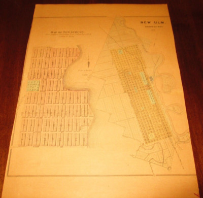
$5.00 Shipping Location: Fort Lauderdale, United States This Auction is for a LARGE unframed AUTHORIZED REPRINT of an Antique map as detailed below. This map is reproduced on specially coated. Matte finish, ... morepaper for sharper print quality and colors that are vivid. These maps are created from VERY high resolution uncompressed TIFF files(averaging 200+ megabytes) and are much sharper that the image shown here. Description of Original Bird's eye view of New Ulm. Brown County, Minnesota 1870. Approximate Image Size 16.5 X 20.5 inches WE HAVE MANY HISTORIC REPRINT MAPS AND OTHER ITEMS ON MANY DIFFERENT SUBJECTS Please check out strore for additonal products ON MULTIBLE ITEM ORDERS-SHIPPING IS FREE TO ADDRESSES IN THE UNITED STATES BY MAIL(GENERALLY 2 TO 5 DAY DELIVERY) FOR ANY NUMBER OF MAPS SHIPPED IN THE US. SHIPPING IS $15 PLUS $1 FOR EACH ADDITIONAL MAP TO ANYWHERE ELSE IN THE WORLD. WE SHIP ALL MAPS ROLLED IN A MAILING TUBE TO PROTECT THE MAP. IF YOU ARE UNHAPPY WITH YOUR PURCHASE SIMPLY RETURN IT AND WE WILL REFUND YOUR MONEY. Ad copyright 2013 J.C. Beck All Rights Reserved Powered by The free listing tool. List your items fast and easy and manage your active items.
Buy It Now
$4.99 Shipping Location: Fairview, United States An Authentic Antique Map: Not a Modern Reproduction! Condition: It is in Good condition for its age with overall light tonal ageing, on a flexible page ... morewith hand coloring. There are a couple of slightly bent corners and a few smudges mainly around the margins, see the pics for more on condition.
Buy It Now
$4.00 Shipping Location: Columbus, United States County Cottonwood. Mountain Lake, Minnesota. Location of Mountain Lake, Minnesota. State Minnesota. • Land 1.53 sq mi (3.96 km. Mountain Lake is a city ... moreinCottonwood County ,Minnesota ,United States. ).
Buy It Now
$4.99 Shipping Location: Fairview, United States It is from Collier's World Atlas and Gazetteer, New York, 1938, a copy of the title page is included for authenticity. Condition: It is in Very Good to ... moreExcellent condition for its age, very clean on strong flexible paper, a similar style map on reverse.
Buy It Now
$12.45 Shipping Location: Radford, United States It has a few spots mostly in the margins but looks great! Has a couple tears in the margins.
Buy It Now
$3.86 Shipping Location: Wilmington, United States Geological and Natural History Survey of Minnesota. Printed by the State of Minnesota Geological Survey. Swift & Chippewa County. Lithographed Color Geology ... moreMap.
Buy It Now
$4.50 Shipping Location: Minneapolis, United States Has stamp marks, may have writing and/or have creases/wrinkles and small tears on or near edges.
Buy It Now
Free Shipping Location: Schertz, United States This piece was removed from an 1874 MINNESOTA STATE Plat Atlas and is in good acceptablecondition. The map is not " new " or in " new " condition & was ... moreprinted in 1874. It is not dated. Study the photos carefully, this is the actual page you will receive.
Buy It Now
$4.45 Shipping Location: Manassas, United States Publisher: Karl Baedeker. Year of printing: 1909. Green color around the map in the photo is a contrasting background on which the map was photographed. ... moreThe map details is sharper than the photo of the map.
Buy It Now
$4.95 Shipping Location: Willow Grove, United States This is an ORIGINAL Minneapolis Minnesota map taken from a 1901 atlas. There is a partial map image and text on the reverse side of this map page.
Buy It Now
Free Shipping Location: Schertz, United States This Map was removed from a 1932 Pictorial Atlas and is in good acceptable condition. The map is not " new " or in " new " condition, it was printed in ... more1932. The map is not dated. Study the photos carefully, this is the actual map you will receive.
Buy It Now
Free Shipping Location: Schertz, United States This Map was removed from an 1910 Minnesota Plat Atlas and is in very good condition. Including Hundreds of RareCivil War. The map is not " new " or in ... more" new " condition, it was printed in 1910. The map is not dated.
Buy It Now
$6.80 Shipping Location: Eagle, United States Presented is an authentic old map taken from a dis-bound atlas published in 1915. Original hand color.
Buy It Now
$4.50 Shipping Location: Minneapolis, United States Has stamp marks, may also have creases/wrinkles and small tears on or near edges.
Buy It Now
$6.75 Shipping Location: Athens, United States 1902 Minnesota Antique Map Vintage Century Atlas United States. Map from The New Century Atlas 1902. Map is about 16" x 11.5". Map has a crease down the ... moremiddle from the fold in the signature. Please see pictures for condition and let me know if you have any questions.
Buy It Now
$5.00 Shipping Location: League City, United States This map has been carefully removed from the atlas it originally appeared in and is perfect for display purposes. It may have writing or other images ... moreon the reverse side of it. It is in very good condition for its age with overall tonal aging and yellowing on the edges.
Buy It Now
Free Shipping Location: Augusta, United States "An Authentic Original Map Not A Reproduction".
Buy It Now
$5.00 Shipping Location: Canada DATE OF ISSUE: 1897.
Buy It Now
$6.00 Shipping Location: Columbia, United States
Buy It Now
$4.99 Shipping Location: Fairview, United States Condition: The map is in Very Good condition with very light tonal aging. The pics are of the actual map. An Authentic Antique Map: Not a Modern Reproduction!
Buy It Now
$4.99 Shipping Location: Fairview, United States The Geological Survey of Minnesota: Final Report. 1900-1901, published by the Geological and Natural History Survey of Minnesota. Condition: The map is ... morein Very Good to Excellent condition with overall light tonal aging, blank on reverse, printed on heavy buff paper.
Buy It Now
$7.99 Shipping Location: Kalamazoo, United States New Athens-Okawville folio, Illinois, 1921, Folios of the Geologic Atlas 213. Syracuse-Lakin folio, Kansas, 1920, Folios of the Geologic Atlas 212. Newell ... morefolio, South Dakota, 1919, Folios of the Geologic Atlas 209.
Buy It Now
$6.16 Shipping Location: Minneapolis, United States 1970s Map Of City Of Ramsey MN. Roland W. Anderson Surveyor.
Buy It Now
$4.50 Shipping Location: Minneapolis, United States Has stamp marks, may also have creases/wrinkles and small tears on or near edges.
Buy It Now
$6.00 Shipping Location: Corunna, United States This is an original 112 year old map, not a copy or reprint.
Buy It Now
Free Shipping Location: Britt, United States
Buy It Now
$9.99 Shipping Location: La Crosse, United States This beautiful lithograph map from 1901 depicts the intricate details of Becker County, Minnesota. The intricate design and vibrant colors make it a wonderful ... moreaddition to any collection. Don't miss out on the opportunity to own this stunning piece of history.
Buy It Now
Free Shipping Location: North Wales, United States 1911 ANTIQUE RAND MCNALLY NEW IDEAL ATLAS MAP-MINNESOTA-UNITED STATES ORIGINAL ANTIQUE ATLAS MAP PLEASE SEE PHOTOS AS PART OF THE DESCRIPTION CONDITION: ... moreMAP IS IN GOOD CONDITION. SIZE: APPROXIMATELY 10" X 13" SHIPPING: U.S. FIRST CLASS RATE - $7.00 - ANY ITEM WHICH SELLS FOR OVER $100 WILL REQUIRE INSURANCE WE COMBINE SHIPPING FOR MULTIPLE WINS. THANK YOU FOR YOUR INTEREST IN OUR AUCTIONS!.
Buy It Now
$4.50 Shipping Location: Minneapolis, United States Has stamp marks, may also have creases/wrinkles and small tears on or near edges.
Buy It Now
$5.00 Shipping Location: Holyoke, United States Original color map of Colorado, taken from a Balch Bros. International Office and Family Atlas of the World; 1891. Reverse side is map of Minnesota. Very ... moregood condition.
Buy It Now
$3.50 Shipping Location: Dover, United States Fredenberg Quadrangle Minnesota- 7.5 Minute Series. Year Published: 1955.
Buy It Now
$3.50 Shipping Location: Dover, United States Plainview Quadrangle Minnesota- 15 Minute Series. Places: Elba, Plainview. Year Published: 1960. The map in the photo is the actual map you will receive.
|
|
|
In
|
1886 Cram Map of Minnesota, Dakota ( pre N S) North Carolina #5
On one side. Dakota( pre north/south) 21.5"x 13.5" doubled) is shown and the other side has 2 individual maps of Minnesota and North Carolina(single maps are each 11.75'x13.5" The condition of these maps is good and they have some discoloration to the edges. See details and know that due to the extenuating age, small wear. dog ears, bends and slight discoloration are common. The actual map coloring is awesome though! Please see photos for individual map condition. These are wonderful for framing. From what I can tell. The book is probably from 1886 and this is based solely on the information in the atlas. That lists dates up to 1886. I am not an expert on maps or old books. Each map has the following information: Geo F. Cram Engraver and Publisher Chicago Ill. Many countries and their borders have changed DRASTICALLY since ... morethe engraving of this map. I will be leaving the paper edge as it was attached to the binding, in order to avoid damage to the map. This is from a book my mom had that was missing the cover and first few pages. She had this for quite a few years and has decided to part with some of the maps included. We carefully took the book apart to retain the character. Please see the other maps we are listing. As we have a total of 26 maps from this book. We are donating 20% to Mercury One and the rest of the proceeds are going to fund the start of our family bakery headed by my dad! IMPORTANT INFO: All photos taken in natural light using no flash. Please use the magnifying tool for close up inspection of these amazing finds! We WILL combine shipping(please contact me for quote) and we do ship internationally utilizing the Global Shipping Program. This is a 7 oz. package and the size is 13”x15”x.50” for one map. Originating from zip code 24557* Priority will be an option as well! 2p5ddv.RcmdId ViewItemDescV4,RlogId p4%60bo7%60jtb9%3Fuk%601d72f%2B26rk%3E2p5ddv-143cd4f90ca-0xfc-
|
|
|
1926 Waseca County Minnesota Plat Atlas Roll Up Map Local Ads & Acreage Tracts
This listing is for the 1926 Waseca County Minnesota Plat Atlas Roll Up Map. Compiled. Engraved, Printed, Copywrited 1926 by The Kenyon Co. Inc. Map Makers, Des Moines, Iowa. Includes the following townships: Janesville, Iosco, Blooming Grove, Alion, St Mary, Woodville, Freedom, Wilton, Otisco, Vivian, Byron and New Richland. Local Advertisements line the outer perimeter of the map. Ones with telephone numbers are 2 and 3 digit. Map shows names of landowners and amount of acres owned. On both sides of the map are the Small Acreage Tracts with names and acreage size. There are tears at the top of the map. Will need repair. There is a small spot missing at the top of Iosco township. See picture. All damage is at the top 12" of the map. The rest is in very good condition. This is a roll up map with wood dowels at top and bottom. Measures ... more38" wide and 48" length. Nice old rare plat atlas. When will you see another available for sale. Don't miss out. Powered by The free listing tool. List your items fast and easy and manage your active items.
|
|
|
MINNEAPOLIS MINNESOTA authentic Antique Map genuine 123 years old made in 1891
MINNEAPOLIS. MINNESOTA Authentic 123-Year-Old Antique Map Printed in 1891. This is a beautiful, 123-year-old color map of the city of Minneapolis. It measures about 11 by 14 inches(about 28 by 36 cm. and is in Fine condition. The map contains a wealth of detail down to the street level, and includes routes of old railroads and horse-drawn street cars. Several old landmarks are shown, many of which are no longer in existence today. This is a guaranteed genuine antique map! Ideal for genealogy or historical research. This map was printed on a single sheet of stock and bound whole in an antique book. There are no folds, creases, marks or stains, and the paper is clean and not brittle. A similar map of St. Paul is printed on the reverse. Highly suitable for framing(see sample presentation below) this map would look great in your office, library, ... moreden or study. It is similar to many of the maps sold in expensive mail-order catalogues and department stores, with one important difference: this is an actual antique. NOT a modern reproduction. An excellent investment. This map is certain to appreciate in value over time. Please ask all questions before making your purchase. SAMPLE DISPLAY IDEA SAMPLE DISPLAY IDEA FREE SHIPPING anywhere in the USA by USPS First Class Mail. Priority and Express services also available. Shipped rolled in a sturdy tube. I ship worldwide! cua91f
|
|
|
1958 MINNESOTA CENTENIAL ROAD MAP
ONLY FAIR CONDITION.DIRTY& STAINED AND SOME RIPS/TEARS AT FOLD CORNERS. OPENS UP TO 32" X 38" COLORED FULL PAGE ROAD MAP ON ONE SIDE. HISTORICAL INFO ON THE OTHER SIDE. PLEASE VISIT OUR EBAY STORE FOR OTHER MAPS AND HISTORICAL COLLECTIBLES. Check out my! Be sure to add me to your! Sign up for; the fast. Easy, and secure way to pay online. Powered by The free listing tool. List your items fast and easy and manage your active items.
|
|
|
1853 SAINT PAUL old MINNESOTA map GENEALOGY atlas poster RAMSEY county MN 026
This Auction is for a LARGE unframed AUTHORIZED REPRINT of an Antique map as detailed below. This map is reproduced on specially coated. Matte finish, paper for sharper print quality and colors that are vivid. These maps are created from VERY high resolution uncompressed TIFF files(averaging 200+ megabytes) and are much sharper that the image shown here. Description of Original City of St. Paul. Capital of Minesota 1853, Approximate Image Size 16.5 X 21.5 inches WE HAVE MANY HISTORIC REPRINT MAPS AND OTHER ITEMS ON MANY DIFFERENT SUBJECTS Please check out strore for additonal products ON MULTIBLE ITEM ORDERS-SHIPPING IS FREE TO ADDRESSES IN THE UNITED STATES BY MAIL(GENERALLY 2 TO 5 DAY DELIVERY) FOR ANY NUMBER OF MAPS SHIPPED IN THE US. SHIPPING IS $15 PLUS $1 FOR EACH ADDITIONAL MAP TO ANYWHERE ELSE IN THE WORLD. WE SHIP ALL MAPS ROLLED ... moreIN A MAILING TUBE TO PROTECT THE MAP. IF YOU ARE UNHAPPY WITH YOUR PURCHASE SIMPLY RETURN IT AND WE WILL REFUND YOUR MONEY. Ad copyright 2013 J.C. Beck All Rights Reserved Powered by The free listing tool. List your items fast and easy and manage your active items.
|
|
|
Vintage 1974-75 AAA Minnesota travel map FREE SHIP
Vintage 1974-75 AAA Minnesota travel map Map has been folded and unfolded many times. May have previous owners markings and spots or tears, but is in good condition. FREE US SHIPPING! Will ship worldwide! Please check with me on costs of shipping outside of the US. Insurance available per buyer request. I save ALL shipping receipts. And am not responsible for the item after it is shipped. Descriptions are to the best of my ability. However. I am not a collector so may not know the best way to describe the item. Please feel free to E-mail me with questions or for more pictures and check out my other auction items. RcmdId ViewItemDescV4,RlogId p4%60bo7%60jtb9%3Fvo%7B2d71f%2B4g7%3E-143e077cecb-0xfe-
|
|
|
1988 Explore Minnesota Official State Highway Map FREE SHIPPING
1988 Explore Minnesota Official State Highway Map Map has been folded and unfolded many times. May have previous owners markings and spots or tears, but is in good condition. FREE US SHIPPING! Will ship worldwide! Please check with me on costs of shipping outside of the US. Insurance available per buyer request. I save ALL shipping receipts. And am not responsible for the item after it is shipped. Descriptions are to the best of my ability. However. I am not a collector so may not know the best way to describe the item. Please feel free to E-mail me with questions or for more pictures and check out my other auction items.
|
|
|
Celebrate Minnesota 1990 Official Minnesota Highway Map FREE SHIPPING
Celebrate Minnesota 1990 Official Minnesota Highway Map Map has been folded and unfolded many times. May have previous owners markings and spots or tears, but is in good condition. FREE US SHIPPING! Will ship worldwide! Please check with me on costs of shipping outside of the US. Insurance available per buyer request. I save ALL shipping receipts. And am not responsible for the item after it is shipped. Descriptions are to the best of my ability. However. I am not a collector so may not know the best way to describe the item. Please feel free to E-mail me with questions or for more pictures and check out my other auction items.
|
|
|
Vintage 1979-80 Official Transportation Minnesota state travel map FREE SHIP
Vintage 1979-80 Official Transportation Minnesota state travel map Map has been folded and unfolded many times. May have previous owners markings and spots or tears, but is in good condition. FREE US SHIPPING! Will ship worldwide! Please check with me on costs of shipping outside of the US. Insurance available per buyer request. I save ALL shipping receipts. And am not responsible for the item after it is shipped. Descriptions are to the best of my ability. However. I am not a collector so may not know the best way to describe the item. Please feel free to E-mail me with questions or for more pictures and check out my other auction items.
|
|
|
Minnesota highway 13 map outline route road traffic sign USED AUTHENTIC
Another interesting. Recently retired sign from the sign man, this time out of the Upper Midwest. This 24" aluminum sign is made with"high intensity" reflective sheeting and features the state map besides the state name(WOW! It is in nice, USED condition and lays completely flat. This sign was obtained legally from scrap. I do have more signs from many states and Canadian provinces available. If you are looking for anything in particular. Feel free to contact me. PLEASE NOTE: e-bay forces us to enter detailed shipping information. Because there are several variables going into the shipping calculation(1. while I am on the road. The point of shipping changes depending on where I am when I receive payment, 2. different signs have different sizes and weights, 3. sometimes I get to combine more than one sign into one parcel, etc. ... moreetc. the shipping"wizard" cannot be accurate. Often the stated rate in my listing is actually too high, but then again it can also be too low at times. PLEASE IGNORE THE SHIPPING COST that appears in the listing. Also, I will NOT ALWAYS be shipping from the stated"item location" in my listing. So, in any case, feel free to contact me during the auction for a more exact quote. DEAR OVERSEAS BIDDERS: shipping costs can vary widely depending on your country, therefore please wait until I invoice you. I will also gladly give you an estimate during the auction. A friendly reminder about my shipping practices: My usual"shipping and handling time" is 1 business day AFTER PAYMENT IS RECEIVED. Shipping is usually listed as"parcel select" Which itself will take one week to ten days. By bidding on my items you agree to those terms. If that is not fast enough, please contact me before the auction ends and I will do my best to accommodate you. Just do me a big favor: after you receive your item, don't give me a slow-ship rating in my DSR if you did receive your item within the outlined timeframe. Thank you for your consideration in this matter. A
|
|
|
Mankato Minnesota Section 14 Township Map from 1914 Blue Earth County Atlas
Here is a original 1914 Blue Earth County Mankato Township Section 14 Map map is 14 1/2 X 17 1/2 inches in size. In excellent bright colored condition, great for framing or genealogy, shows landowners& land they owned in 1914, also shows route of Minnesota& Blue Earth Rivers through town, shows Riverside Addition, Sibley Park, Sibley Mound, Givens& Lewis Additions.Check scan will combine S&H with other maps. good luck bidding.
|
|
|
1975 Minnesota road map Standard oil gas directory
1975 Minnesota road map Standard oil gas directory. Shows interstate construction. Check out my! Check out my store. All the Old Roads. I have over 4,000 maps and brochures most dated and all with accurate descriptions. Be sure to add me to your! If I have made a mistake in dating or in the description of the item. I will refund your money and pay for return postage. Powered by The free listing tool. List your items fast and easy and manage your active items.
|
|
|
1976 SKI AREA MAP Central United States Michigan Wisconsin Minnesota Iowa Ohio
1976 SKI AREA MAP Central United States Michigan Wisconsin Minnesota Iowa Ohio Handsome fold-out map brochure locating ski areas in the central United States. Printed more than 37 years ago. The map opens up to 50 x 68.5 cm[19-3/4" x 28-1/2" It has great detail on old road alignments and ski areas in Michigan. Wisconsin, Minnesota and parts of Ohio, Indiana, Illinois, and Iowa. The scan below shows one side of the map opened up: Among the named places are Boston Mills. Timber Ridge, Caberfae, Skyline, Powderhorn Mountain, Sundown, Plumtree, Buck Hill, Spirit Mountain, Afton Alps, Indianhead, and more. This map was published by the National Survey of Chester. Vermont and is dated 1976 on the cover. Condition: This map is in very good condition, bright and clean. With no marks. Rips or tears. We are pleased to offer it with our unconditional. ... moreMoney-back guarantee. SHIPPING: We gladly ship anywhere in the World. And we use sturdy, professional packing materials to assure safe delivery. The shipping charges are as follows: Within the United States. Including Alaska, Hawaii, and APO addresses: $2.89 To Canada or Mexico: $8.79 To all other international destinations: $12.99(These charges reflect rates set by the United States Postal Service for domestic and international delivery. We will appreciate your prompt payment for this item. If you need more time or have any other questions about making your payment. Or if you may desire any special services, such as overnight delivery, please contact us. Florida residents add 6.5% sales tax. Be sure to check our auction listings on eBay for other antique and collectible maps and ephemera. Simply click on the link below. Many of the items offered can be combined with this purchase so you can save on shipping. LOOKING FOR SOMETHING SPECIAL? Search Titles and Descriptions Make it even easier to keep track of our eBay store and auction offerings! Click to add us to your Favorites List. Your satisfaction is guaranteed. Buy with confidence. We've been serving map and
|
|
|
1938 Vintage MAP of MINNESOTA MN Beautiful Vintage 1930s State MAP
VINTAGE MAP OF MINNESOTA. This is an original. Not reproduction, vintage map which was carefully removed from an atlas. Map measures approximately 9 x 12.5 and is in very good condition. Your item will be packaged in a plastic sleeve. Within a cardboard mailing tube. We happily combine purchases to save on shipping fees. Please email with questions. We will answer your email promptly! Please visit our ebay store. Plaindealing Vintage Paper. Check out my! Powered by The free listing tool. List your items fast and easy and manage your active items.
|
|
|
1895 RARE BEAUTIFUL MCNALLY'S ANTIQUE ATLAS MAP-MINNESOTA-NICE COLOR-DETAIL
1895 RARE BEAUTIFUL MCNALLY'S ANTIQUE ATLAS MAP-MINNESOTA-NICE COLOR-DETAIL, Click to View Image Album 1895 RARE BEAUTIFUL MCNALLY'S ANTIQUE ATLAS MAP-MINNESOTA-NICE COLOR-DETAIL BEAUTIFUL DETAILED RARE RAND MCNALLY'S COMMERCIAL AND POLITICAL ATLAS MAP INCLUDES CITIES. LANDMARKS, INDUSTRY, BUSINESS AND RAILWAYS PLEASE SEE PHOTOS AS PART OF THE DESCRIPTION CONDITION: MAP IS IN GOOD CONDITION-NICE VIVID COLOR SIZE: APPROXIMATELY 11" X 13" SHIPPING: U.S. FIRST CLASS RATE- $4.00. CANADA- $9.00. WORLDWIDE- $14.00 WE COMBINE SHIPPING FOR MULTIPLE WINS! THANK YOU FOR YOUR INTEREST IN OUR AUCTIONS WILL MAKE A UNIQUE GIFT FOR THE HOLIDAYS! Payment I accept the following forms of payment: PayPal Shipping& Handling $4.00 USPS First-Class Mail® FREE scheduling. Supersized images and templates. Get Vendio Sales Manager. ... moreFREE scheduling. Supersized images and templates. Get Vendio Sales Manager. Over 100.000,000 served. Get FREE counters from Vendio today!
|
|
|
1900 ST PAUL Minnesota Antique MAP Vintage Collectible Atlas Map
ANTIQUE COLLECTIBLE MAP of ST PAUL MINNESOTA This is an original. Not reproduction, vintage map which was carefully removed from an atlas. Map measures approximately 12.5" by 9" and is in very good condition. There is an index beyond the black border. I happily combine purchases to save on shipping fees. Your item will be packaged in a plastic sleeve. And shipped in a cardboard mailing tube. Please email with questions. I will answer your email promptly! Be sure to add me to your! Check out my! Powered by The free listing tool. List your items fast and easy and manage your active items.
|
|
|
VTG Minnesota State Handkerchief Hankie Hanky Map Souvenir Handmade Embroidered
You are bidding on a Vintage/Antique Handmade Minnesota State Map Handkerchief/Hanky! This is old- I bought it at an Estate sale- looks to be clean and unused. A little spot where the sticker came off. Very cool souvenir. The Hanky is a thin material. Winning bidder pays $1.95 shipping. I have more available if interested. Powered by The free listing tool. List your items fast and easy and manage your active items.
|
|
|
1890 Antique Geologic Map: Gunflint & Loon Lake & Vicinity, Minnesota MN.
1890 Geologic Map: Gunflint& Loon Lake& Vicinity. Minnesota MN. Original. PUBLISHED BY THE GOVERNMENT PRINTING OFFICE. WASHINGTON, DC. 1890. Size: Approx 11.25 X 7.5 INCHES(ENTIRE SHEET) IMAGE AREA A LITTLE SMALLER. Condition: IMAGE AREA IS FINE. MARGINS ARE VERY GOOD. SEE PHOTO. Due to age. Small imperfections are to be expected. Please view the photos to make your own assessment. Returns: Any item may be returned for a refund. Please contact us within 14 days of receipt of your item if you feel an error has been made. We do not deal in modern reproductions. All of our maps are original and authentic. Please browse other maps at our store. inkfrog terapeak. I000000.
|
|
|
1866 OREGON WASHINGTON MINNESOTA Map JOHNSON ATLAS CIVIL WAR Hand Watercolor
2 ORIGINAL antique 1866 maps from JOHNSON'S New Illustrated FAMILY ATLAS printed on one large page. On the left page is a map of OREGON and WASHINGTON STATE. The right page is a map of MINNESOTA. The map of MINNESOTA shows a handful of railroads at the time while the OREGON/WA map shows numerous proposed rail routes. Both maps show scores of overland roads many of which are named that include Emigrant Roads(one of which is the Oregon Trail) Early explorer routes, mine roads, wagon routes, and stage coach routes. Counties are individually named and hand water colored. The map also shows the location of dozens of Western Indian Tribal lands. This is a RARE and interesting map with a HUGE amount of detail on it. Among the finest maps produced during the 19th Century. Johnson's maps were used extensively during the Civil War. The map ... moremeasures 26 by 18 inches and is perfect for matting and framing. This ORIGINAL antique map is guaranteed over 145 years old, published just after the CIVIL WAR. I do not sell reproductions, just honest maps at honest prices. Discounted shipping too. NO international shipping. NO exceptions. All items shipped within 2 business days after payment. If you have not received an item in a reasonable amount of time please email me. It has been delayed by the Post Office. I also accept returns on ANY item for ANY reason, please email me I am very easy to work with. Feedback is not the same thing as an email, please email first. On Oct-19-07 at 13:06:06 PDT. Seller added the following information:
|
|
|
HUGE GORGEOUS ANTIQUE 1876 MICHIGAN WISCONSIN MINNESOTA IOWA HANDCOLORED MAP NR
Click Here. Double your traffic. Get Vendio Gallery- Now FREE! Vintage antique 1876 handcolored map. The map is titled. In fancy antique lettering,Map of Michigan, Wisconsin, Minnesota and Iowa. The period handcoloring on the map is superb. Very detailed and attractive period map of this area at this time. I see many fascianting areas. The map is in beautiful fine conditon. This is an antique map and not a reprint or reproduction. The handcoloring on the map is period to the map, this is before color printing. The map is from the very rare 1876 Hardesty Atlas of Defiance County Ohio. The map is a fascinating and historic period look at this area at this time. The photo wont show the full beauty of the map. The size of the map is large 14.5" by 19.5" Winning bidder pays $3.75 shipping domestic, more foreign. Payment I accept the ... morefollowing forms of payment: PayPal Click to View Image Album Shipping& Handling US Shipping. $3.75 USPS First-Class Mail® International Shipping. $11.50 USPS First-Class Mail International FREE scheduling. Supersized images and templates. Get Vendio Sales Manager. FREE scheduling. Supersized images and templates. Get Vendio Sales Manager. RcmdId ViewItemDescV4,RlogId p4%60bo7%60jtb9%3Fvo%7B%3Dd70f%2Bf54%3E-1440a3aadab-0xef-
|
|
|
Whimsical MINNESOTA Map Skating MAYO Clinic Hunting FUN 1940s Picture Map
VINTAGE PICTURE MAP OF MINNESOTA This whimsical pictorial map features amusing sketches of characters farming. The Mayo Clinic, an Indian with pipe, hunting, a chef with sausages, and more. I think it would be fun to frame several of these maps and display them in a group. A grouping might include your birthplace. Places you have visited on vacation or a honeymoon. These make fun gifts! This is an original. Not reproduction, vintage picture map which was carefully removed from a 1946 book. The print measures approximately 4" by 5" and is in very good condition. Your item will be packaged in a plastic sleeve. With a thin piece of backing, then in a manila envelope with a very stiff and thick piece of cardboard. We happily combine purchases to save on shipping fees. Please email with questions. We will answer your email promptly! ... morePlease visit our ebay store. Plaindealing Vintage Paper. Be sure to add me to your! Check out my! Powered by The free listing tool. List your items fast and easy and manage your active items. lm3vhp.RcmdId ViewItemDescV4,RlogId p4%60bo7%60jtb9%3Fuk%601d72f%2Bjw%60%3Elm3vhp-1440a3c4128-0xfc-
|
|
|
1911 Genuine Large Antique Color Map of Minnesota, From George Cram atlas
This auction features a large George Cram. Double-page, detailed, multi-color map of Minnesota. The map was extracted from the George Cram Modern Atlas-the World, published in 1911, which was in unsalvageable condition. The last two photos validate the origin of the map and its publishing date. This map has a total page size of 15-1/8" wide x 22-1/8" long. And an image size of 13-1/2" wide x 20-1/8" long. The map's condition is excellent, with only a little yellowing of the white margins and minor paper tears in the margin. The map image is in excellent condition. The brilliant colors are exceptionally clear and crisp with very little fading(see photos) This map will be carefully wrapped. Rolled, and shipped in a durable mailing tube, via US Postal First Class Parcel Service. International Buyers. Please contact me ... morefor a shipping and handling quotation before bidding. 3c0.RcmdId ViewItemDescV4,RlogId p4%60bo7%60jtb9%3Feog4d71f%2B%3E3c0-1440a3c410c-0xec-
|
|
|
VTG MAP OF ST. LOUIS COUNTY MINNESOTA/MINN/MN * DULUTH/LAKE SUPERIOR
I HAVE A BUNCH OF OTHER DULUTH ITEMS ON NOW TOO! T HIS AUCTION IS FOR A VINTAGE MAP OF ST. LOUIS COUNTY MINNESOTA. SAYS"PREPARED FROM OFFICIAL SURVEYS" CO. HIGHWAY DEPARTMENT" ABOUT 44" X 21" UNDATED. IN USED CONDITION WITH FEW TEARS AT SEAMS. LOOK VERY CLOSELY AT PICTURES) THE PICTURES ARE PART OF THE DESCRIPTION. SOLD AS/IS. NO RETURNS. STANDARD MAIL/HANDLING& DELIVERY CONFIRMATION WILL BE $4.5 0 TO(L OWER 48 STATES) NO INTERNATIONAL SHIPPING! PLEASE READ THE WHOLE AUCTION PAGE BEFORE BIDDING! PLEASE EMAIL AND ASK ANY QUESTIONS OR FOR MORE PICTURES BEFORE BIDDING. ITEM SOLD AS/IS) MUST PAY WITHIN 5 DAYS OF END OF AUCTION. BUYER'S MUST ASK FOR INSURANCE ON ITEM IF WANTED IN CASE OF LOST OR BROKEN ITEMS SENT THRU MAIL! DELIVERY CONF IRMATION IS REQUIRED ON ALL ITEMS AND IS ADDED IN THE SHIPPING COST. I DO ... moreCOMBINE TO SAVE ON SHIPPING COST AFTER THE AUCTION WITH THE HIGHEST S/H FEE. A MINIMUM CHARGE OF $.75 HANDLING FEE FOR EACH EXTRA AUCTION WON(UNDER 1/2 POUND ONLY) FEE VARIES BY WEIGHT OVER 1/2 POUND T he MAIL service transit time. Transit times are provided by the carrier. Exclude weekends and holidays, and may vary with package origin and destination, particularly during peak periods. THANK YOU VERY MUCH FOR LOOKING!
|
|
|
MINNEAPOLIS MINNESOTA STREET CITY MAP RAND MCNALLY ATLAS MAP
1944 CITY MAP OF MINNEAPOLIS MINNESOTA ISSUED BY RAND MCNALLY ATLAS COMPANY DATE 1944 THIS AUCTION IS FOR AN ORIGINAL MAP FROM 1944 SHOWING STREETS. PARKS AND POINTS OF INTEREST IN THE AREA. ALL WATERWAYS AS WELL AS RAILROAD ROUTES ARE SHOWN. MEASURES 11 X 14 INCHES CONDITION FAIR. VERY MINOR DISCOLORATION DUE TO AGE I DO COMBINE SHIPPING ON MULTIPLE PURCHASES
|
|
|
Mankato Minnesota Section 8 Original Township Map from 1914 Atlas
Here is a original 1914 Blue Earth county Mankato Township Map of Section 8 showing the Calvary Cemetery location& Land owners& land they owned in 1914. Map 14 1/2 X 17 1/2 inches in size Excellent bright colored condition, great for framing check scans, will combine S&H with other maps. Good luck bidding.
|
|
|
Map~Iron Mining District Vermilion, Minnesota~11 X 27"~1900~USGS~Geological Map
This 11 by 27" map is of the Iron Mining District of Vermilion. Minnesota. The map is undated but was found in an USGS publication dated 1900. This map is excellent reguarding color and detail. There are many mines identified between Ely and Tower. The Minnesota Mines got started some 40 years after the Michigan Mines so a map of this age shows these mines at a young age. Great map. U. S. buyers only. Powered by The free listing tool. List your items fast and easy and manage your active items.
|
|
|
Map~Iron Mining District Mesabi, Minnesota~18 X 48"~1900~USGS~Geological Map
This 18 by 48" HUGE map is of the Iron Mining District of Mesabi. Minnesota. The map is undated but was found in an USGS publication dated 1900. This map is excellent reguarding color and detail. There are many mines identified between Hibbing an Biwabik. The Minnesota Mines got started some 40 years after the Michigan Mines so a map of this age shows these mines at a young age. This 4 foot long map is one of the bigger maps I have seen on the Iron Mines of Minnesota. U. S. buyers only. Powered by The free listing tool. List your items fast and easy and manage your active items.
|
|
|
ANTIQUE MAP OF THE CITY OF ST. PAUL MINNESOTA W/ CEMETERIES, RAILROADS DETAILED
Antique. Color, 1889 CRAM'S ATLAS OF THE WORLD map of THE CITY OF ST. PAUL. SHOWS STREET RAILROADS. STEAM RAILROADS, UNION STOCK YARDS, STATE UNIVERSITY FARM, STATE FAIR GROUNDS, COMO PARK, STATE REFORM SCHOOL& FARM, UNION PARK, CALVARY CEMETERY, OAKLAND CEMETERY, LAKE PHALEN, SIXTH WARD LEVEE, AND MUCH MORE! ALL STREETS ARE NAMED. TRULY A BEAUTIFUL MAP! WHAT A GREAT UNIQUE GIFT FOR THE PERSON WHO HAS EVERYTHING! WOULD LOOK GREAT HANGING IN A HOME OR OFFICE. CREATIVE CHRISTMAS GIFT! The map image is in GREAT CONDITION. Image is very clear. Legible, and COLORFUL. I combine multiple items to save on shipping fees. I SHIP MAPS FLAT AND PROTECTED 5 DAYS A WEEK. GREAT FOR SCHOOL PROJECT! BUY WITH CONFIDENCE! SEE MY FEEDBACKS! THIS MAP WAS PRINTED IN 1889& IS NOT A REPRODUCTION. GREAT UNIQUE GIFT IDEA FOR THE PERSON WHO HAS EVERYTHING! ... moreALSO WOULD BE IDEAL FOR A SCHOOL PROJECT. SEE MY PROMOTIONAL SHIPPING RATES! I WILL SHIP TO MULTIPLE ADDRESSES WHICH IS IDEAL FOR GIVING GIFTS. UPON REQUEST. I WILL PUT A NICE CARD WITH THE MAP WITH THE MESSAGE YOU PROVIDE. YOU DON'T HAVE TO GO SHOPPING AND IT WILL BE DELIVERED AT THE DOOR! IT DOESN'T GET ANY EASIER THAN THAT! TAKE A LOOK AT MY OTHER MAPS!
|
|
|
PURE gas oil MINNESOTA MAP Rand McNally early 1950's Firebird gasoline
Early 1950's Vintage/ Pure Oil and Gasoline Gas Station Road Map of Minnesota in very good condition see pics( older PURE firebird OIL/ GAS state map for MINNESOTA. Made by Rand McNally Co. you can learn and see what life was like back in yesteryear, cities, towns, counties with population, what roads were there and changed since then and compare it to todays life, more information, capital, etc. would date this early 50's, it refrences the census of 1950 the next census was done 1956. ANY QUESTIONS FEEL FREE TO ASK.
|
|
|
1940s Pure Oil Company Minnesota Pathfinder Road Map
1940s Pure Oil Company Minnesota Pathfinder fold out Road Map. Size: Approximately 20" 26 1/2" inches Condition: Light corner and edge wear. Some light spotting and marks on both sides of the map. Some splitting along some seams.
|
|
|
LARGE ORIGINAL 1857 DAKOTAH DAKOTA & MINNESOTA MAP COLTON ATLAS HAND COLORED
Antique Map from Colton's Atlas of America. 1857 Original 157 year old antique map from Colton's Atlas of America. The scarce advertising atlas with numerous full and half page advertisements in addition to the maps. We purchased the atlas as a partial one with some of the advertisements removed. We've included an image of the title page(not included as part of this auction) below, just for informational purposes. The overall size of the page is an impressive 18.5" x 16" The map was printed and then hand watercolored to show the various counties and other divisions. It provides a fascinating snapshot view of the area's geographical details at the time of publication 157 years ago. This map includes Minnesota and Dakotah. Portions of which were later to become parts of North and South Dakota. Condition is very good. ... moreAnd much nicer than the image would suggest. There is some modest age-darkening around the edges, otherwise the map is very clean. It's not as dark as the photo would suggest. And the printing is sharp and clear. The reverse side is blank. See the image for condition details. But frankly, the image really doesn't do it any justice. We are/will be offering many of these maps on eBay. As well as some of the better advertisements. They will all be offered at low opening bids with no reserves. These are all genuine items, not cheesy reproductions or reprints. Please visit our other listings to view them. Free Priority shipping in the United States. Due to their size. These maps will be carefully rolled, wrapped in plastic, and mailed in a tube. We have been shipping books and other items for 17 years, so we have learned to pack carefully and safely. If you plan to purchase more than one of these maps or other items. Please do not pay until you're done bidding. We'd prefer to ship them together. Reminder: the image of the title page below is for informational purposes only- it is NOT included as part of this auction. And please do not ask for photocopies of it since
|
|
|
Vintage Minnesota Foldout Map -1950 Official Highway Map
Visit the eBay store to see what category is on sale this week. A 1950 map of Minnesota. Full of nostalgia and lovely mid century graphics. State map on one side, city maps and illustrations on the other side. Published by the State of Minnesota Department of Highways. Saint Paul. Measures about 4 1/2 x 9 inches completely folded. And 32 x 38 inches when unfolded. In very good vintage condition. With no tears, stains or other damage. Has minor edge wear as would be expected from a gently used vintage item. Lots more in the SkippiDiddle eBay store. Lots more maps to list. Message me if you don't see what you're looking for and I'll check my extensive inventory. How to Get a Combined Shipping Discount If purchasing multiple paper items(ads. Maps, prints) first add all the items to your cart. Do NOT click on“Buy It Now” for each ... moreindividual item– first add everything to your cart. When you are done shopping, check the cart for a combined shipping discount(look for green savings near the bottom) If purchasing only paper items, it will usually be correct and show shipping for one paper item and a discount for the other and you go ahead and place the order. If purchasing items of different types or sizes, the full combined shipping discount may not show. Please"request invoice from seller" so that I can send you an invoice with the correct shipping charges. Important: Items remain available for purchase by others until paid for. I usually send invoices very quickly. But there is always a chance that someone else will purchase the item. If you do not request a combined shipping invoice and overpay for shipping, I will still refund the overpayment minus 15% to cover my additional fees) The transaction will be cancelled if the invoice is not paid within 2 days. Powered by The free listing tool. List your items fast and easy and manage your active items.
|
|
|
LARGE HANDSOME HAND TINTED ANTIQUE MAP OF MINNESOTA 1867 J H COLTON 51
DATED 1867 TEAR LEFT SIDE) GET THEM WHILE YOU CAN. MAPS FROM THIS ATLAS DON'T SHOW UP THAT OFTEN AT THESE PRICES. THIS MAP WAS RESCUED FROM A DERELICT J H COLTON ATLAS OF THE WORLD. THIS ATLAS. BOTH VOLUMES, CAN SELL FOR AS MUCH AS $6500. THE 1855 MAPS STATE" ENTERED ACCORDING TO ACT OF CONGRESS IN 1855 BY J. H. COLTON& CO IN THE DISTRICT COURT FOR THE SOUTHERN DIST. OF NEW YORK" SEVERAL MAPS HAVE DIFFERENT LATER DATES, SO THESE ARE FROM A LATER ATLAS. THE ENGRAVING IS VERY BEAUTIFUL AND INTRICATE. I HAVE INCLUDED A COUPLE OF GENERIC CLOSE UPS SO YOU CAN GET AN IDEA OF THE INTRICACY. THIS MAP WILL BE SHIPPED IN A TUBE. IT IS FRAGILE, WILL TEAR EASILY IF MISS-HANDLED. THIS IS A DOUBLE PAGE MAP AND MEASURES APROXIMENTLY 17.25" X 28" THERE IS TEXT ON THE BACK. I WILL TRY TO NOTE ALL DAMAGE NOT VISIBLE IN THE PHOTOGRAPH ... moreBUT BE FOREWARNED I MIGHT MISS A SMALL TEAR. THESE SHOULD BE DRY MOUNTED OR SANDWICHED ASAP. THE MINOR DISCOLORATION AROUND THE EDGE IS EVIDENT IN THE PHOTO. IF YOU KNOW, OR ARE A WATER COLOR ARTIST THESE CAN BE TINTED MORE. I SAW ONE FRAMED WITH THE BORDER DONE. KNOCK OUT! I WONDER, ALMOST 160 YEARS AGO, HOW MANY COULD A TINTIST TINT IN A DAY? Joseph Hutchins Colton(July 5, 1800– July 29, 1893) known professionally as J.H. Colton, founded an American mapmaking company which was an international leader in the map publishing industry between 1831 and 1890.1] Colton was born in Longmeadow, Massachusetts, and moved to New York in 1831 to establish his firm.2] For the first ten years, Colton licensed the use of maps from established engravers such as Samuel Stiles and David H. Burr. Colton went on to create railroad maps, immigrant guides, folding pocket maps, large wall maps, and elaborate atlases. J.H. Colton Company maps were printed using engraved steel plates, which produced higher quality prints than maps made with less costly wax engravings. They were often individually hand watercolored and were recognized for their decorative borders.3] They were also the first maps to
|
|
|
1937 MAP OF MISSISSIPPI JACKSON / MINNESOTA MINNEAPOLIS DULUTH
1937 MAP OF MISSISSIPPI JACKSON/ MINNESOTA MINNEAPOLIS DULUTH This original antique map gives you an opportunity to examine in exquisite detail a piece of history. If you are interested in the past of this country and its people or have a desire to study where your family may have come from. Then this map gives you a rare look as the area was about 70 years ago. Once matted and framed, this map would make a perfect gift for a family member or friend they'll cherish forever. Origin of the map: Collier's World Atlas& Gazetteer edited by Collier& Sons. USA. Date of issue: 1937 Size: The sheet measures 14" x 10 3/4" 36 x 27 cm) S/H: The map will be shipped by Air Mail. The shipping charge is: USA- 8.00 USD. World- 9.00 USD, Canada- 9.00 USD. The price includes the insurance and a strong, cardboard tube with plastic plugs. ... moreAttention! There is no additional shipping charge for multiple purchases! Pay me securely with any major credit card through PayPal! Payment methods: US/Canada Buyers: Paypal International Buyers: Paypal. Click Here. Double your traffic. Get Vendio Gallery- Now FREE! USED USED. AN ORIGINAL ANTIQUE MAP. USED.
|
|
|
c1920 MINNESOTA Map AUTO TRAILS Map Neat RED WHITE & BLUE Vintage 1920s Map
ANTIQUE MINNESOTA MAP with AUTO TRAILS Neat. Uncommon map showing auto routes in a red, white, and blue color scheme. This is an original. Not reproduction, vintage map which was carefully removed from an atlas. This uncommon map measures approximately 10" by 14" and is in very good condition. Please notice stain on left side. Your item will be shipped First Class in a cardboard mailing tube. We happily combine purchases to save on shipping fees. Please email with questions. We will answer your email promptly! Please visit our ebay store. Plaindealing Vintage Paper. Be sure to add me to your! Check out my! Powered by The free listing tool. List your items fast and easy and manage your active items. RcmdId ViewItemDescV4,RlogId p4%60bo7%60jtb9%3Fuk.rp*3A%3Cd%3Ff6%3E-1440bda54f7-0xdf-
|
|
|
MINNESOTA authentic Vintage Map TWIN CITIES
This image is enlarged to show representative detail. MINNESOTA Authentic 65-Year-Old Vintage Map Printed in 1949. This is a beautiful, 65-year-old map of the State of Minnesota. It measures about 11 by 14 inches(about 28 by 36 cm. and is in Fine condition. The map contains a wealth of detail including latitude and longitude, topographical features, counties, cities and villages, Indian reservations, routes of old railroads, and more. An inset shows enlarged detail of the Twin Cities of St. Paul and Minneapolis. This is a guaranteed genuine vintage map! Ideal for genealogy or historical research. This map was printed on a single sheet of stock and bound whole in an antique book. There are no folds or creases, and the paper is clean and not brittle. A similar map of Mississippi is printed on the reverse. Highly suitable for framing, this map ... morewould look great in your office, library, den or study. It is similar to many of the maps sold in expensive mail-order catalogues and department stores, with one important difference: this is an actual antique. NOT a modern reproduction. A great investment. This map is certain to appreciate in value over time. Please ask all questions before making your purchase. FREE SHIPPING anywhere in the USA by USPS First Class Mail. Priority and Express services also available. Shipped rolled in a sturdy tube. I ship worldwide!
|
|
|
VTG 1959 BLUE PRINT PROPASAL MAP OF INTERSTATE IN DULUTH MINNESOTA/MINN/MN
T HIS AUCTION IS FOR A VINTAGE 1959 BLUE PRINT PROPASAL MAP OF INTERSTATE 35 IN DULUTH MINNESOTA FOR PUBLIC HEARING. THE INTERSTATE 35 PRINT IS ABOUT 35" X 12" DATED 1959. IN USED CONDITION. LOOK VERY CLOSELY AT PICTURES) THE PICTURES ARE PART OF THE DESCRIPTION. SOLD AS/IS. NO RETURNS. STANDARD MAIL/HANDLING& DELIVERY CONFIRMATION WILL BE $ 3.5 0 TO(L OWER 48 STATES) NO INTERNATIONAL SHIPPING! PLEASE READ THE WHOLE AUCTION PAGE BEFORE BIDDING! PLEASE EMAIL AND ASK ANY QUESTIONS OR FOR MORE PICTURES BEFORE BIDDING. ITEM SOLD AS/IS) MUST PAY WITHIN 5 DAYS OF END OF AUCTION. BUYER'S MUST ASK FOR INSURANCE ON ITEM IF WANTED IN CASE OF LOST OR BROKEN ITEMS SENT THRU MAIL! DELIVERY CONF IRMATION IS REQUIRED ON ALL ITEMS AND IS ADDED IN THE SHIPPING COST. I DO COMBINE TO SAVE ON SHIPPING COST AFTER THE AUCTION WITH THE HIGHEST ... moreS/H FEE. A MINIMUM CHARGE OF $.75 HANDLING FEE FOR EACH EXTRA AUCTION WON(UNDER 1/2 POUND ONLY) FEE VARIES BY WEIGHT OVER 1/2 POUND T he MAIL service transit time. Transit times are provided by the carrier. Exclude weekends and holidays, and may vary with package origin and destination, particularly during peak periods. THANK YOU VERY MUCH FOR LOOKING!
|
|
|
Rand McNally Railroad Map of Midwest Minnesota Nebraska Wisconsin Dakota c.1927
Click to Enlarge Click to Enlarge Railroad Map of Midwestern United States by Rand McNally. 1927. Excellent lithographic map of North and South Dakota. Minnesota, Wisconsin and the rest of the midwest. Printed by Rand McNally for the LaSalle University Commercial Atlas in 1927. Second-run printing in red denotes Western Trunk Line Committee territory. Text on reverse. Map is in very good condition and would look great framed. Measures 14.25 x 16.75 inches. Will ship folded in package. Please note we do not ship internationally. And all California residents will be charged 8.75% sales tax. Thanks for looking! Learn more about our store on our About Me page: inkfrog terapeak. Inkfrog terapeak. I000000. InkFrog Analytics.
|
|
|
FAHLUN TOWNSHIP KANDIYOHI COUNTY MINNESOTA RARE 1905 ANTIQUE COLOR MAP GENEALOGY
FAHLUN TOWNSHIP KANDIYOHI COUNTY MINNESOTA RARE 1905 ANTIQUE COLOR MAP GENEALOGY, FAHLUN TOWNSHIP. KANDIYOHI COUNTY MINNESOTA, RARE 1905 ANTIQUE MAP, GENEALOGY This is a RARE and beautiful genuine color antique map of FAHLUN of KANDIYOHI COUNTY MINNESOTA. Published in"ILLUSTRATED HISTORY of KANDIYOHI COUNTY MINNESOTA" published in 1905. This genuine/original antique map from the year 1905 is 12 x 15 inches in size with wide margins. It is in excellent condition, highly displayable and ready for framing and is guaranteed to be as described. This beautiful and decorative RARE antique map of FAHLUN Township in Kandiyohi County Minnesota would make a great addition to any home or office or Restaurant decor! I have provided Antique Engravings. Prints, Maps& Newspapers globally to museums. Institutions, art dealers, researchers, genealogists, ... moremovie sets, interior designers, curators, authors, knowledgeable collectors and beginners too. The comments buyers have made in my"feedback" file are an indication of the quality product and exceptional service I deliver. Authenticity of all items. As described in each listing, and the accuracy of that description, is guaranteed unconditionally. Shipping will be $6.50. International airmail shipping will be $18. All items will be shipped in a acid free archival poly bag and securely packaged in a sturdy reusable flat or mailing tube to assure safe delivery. I will combine multiple purchases for just one shipping charge. Feedback will be left on all transactions and I would appreciate you doing the same. Payment must be received no later than 10 days after the close of the auction. Payment through PayPal. I have had very few inquiries for item returns. In the event of such a request. The transaction will be evaluated and a refund offered if the item differs substantially from the description presented. My goal is Customer Satisfaction for both Buyers and Consignors! At your fingertips here at this website you have a gallery of many thousands of Antique Engra
|
|
|
Original 1940 Map of Minneapolis Minnesota Rand McNally
Beautiful Map of Minneapolis. Print measures 11" x 14" Print from Collier's World Atlas and Gazetteer copyright 1940. 1?RcmdId ViewItemDescV4,RlogId p4%60bo7%60jtb9%3Feog4d72f%2B%3E%3B1%3F-1440a3c9ca2-0x109-
|
|
|
1915 MINNESOTA STATE MAP SHOWS COUNTIES UNCOLORED FROM THOMAS HILL'S BOOK
TITLE MINNESOTA DATE 1915. NOT ON MAP ISSUED AND PUBLISHED BY THOMAS HILL'S BOOK"THE OPEN DOOR TO INDEPENDENCE-MAKING MONEY FROM THE SOIL" PUBLISHED 1915 MAP SHOWS ALL COUNTIES WITHIN THE STATE. SOME POPULATION INFORMATION IS ON MAP BUT IS NOT COMPLETE. TEXT ON REVERSE ENTIRE PAGE MEASURES 9.5 X 6.5 INCHES FAIR CONDITION MINOR DISCOLORATION DUE TO AGE.
|
|
|
AQntique 1924 City Map Montreal, Quebec, Canada & Minneapolis/ St Paul Minnesota
Vintage 1924 OLD Post WWI City Map Montreal. Quebec, Canada And Minneapolis& St. Paul. Minnesota A Great Gift! Great OLD Map from the"COLLIER'S NEW WORLD ATLAS& GAZETTEER" Copyright 1924 90 Years Old! The Actual Page! NOT a Copy! Montreal. Quebec, Canada On One Side Minneapolis& St. Paul. MN On The Other Side(Contact Us For More Pictures) This Page Measures About 10 1/4 x 15" Map Shows Points of Interest. Parks, Cemetaries, Islands, The St. Lawrence River, Notre Dame, Mississippi River, Lakes, Parks, Public Buildings, Etc. Very Educational. See what the Cities used to look like! Post WWI Black& White It Will Look Great Matted& Framed! A Really Nice Gift! A GREAT House Warming Gift! The Perfect Anytime Gift! Teachers& Politicians LOVE Them! Super For a Local Business or Office! Shipping by 1st Class ... moreor Priority Mail We Will Combine Shipping on Up To 4 Maps for the same shipping fee Email Us With Any Questions or For an International Shipping Quote Check out my other items! Be sure to add me to your favorites list! Thanks For Looking! International Buyers– Please Note: Import duties. Taxes, and charges are not included in the item price or shipping cost. These charges are the buyer's responsibility. Please check with your country's customs office to determine what these additional costs will be prior to bidding or buying.
|
|
|
Minnesota Antique Colour Map: 1903 Original and Historical - Minnesota, USA
Original Antique Map or Plan: Minnesota. USA(1903) inserts- Duluth& Minneapolis/St. Paul Historical. Early 20th Century(Ref: 1903_98) Page size 16¼" x 11⅝" 415mm x 295mm) approximate(including the margins) Image shown in two sections due to scanner limitations but item is in one piece) Date printed: 1903. A fine example of an antique map in colour. The third image shows an enlarged section view. Guaranteed a 111 year old original item. SOURCE: disbound book: Encyclopaedia Britannica- A new. Distinctive, and Independent Library of Reference dealing with recent events and developments(The Tenth Edition) Published by: Adam& Charles Black. Edinburgh& London/ The Times, Printing House Square, London- 1903. The map also shows attribution to The Matthews-Northrup Works. Blank on verso(reverse side) This item is ideal for ... moremounting and framing and is certain to be a conversation piece! CONDITION: Please examine the scanned image(s) Even age tanning and bumping to corners. Edges rubbed, minor foxing. Original fold/crease running from left to right common to this type of map- otherwise in a good condition for the extreme age of the item. Genuine antique print- not a modern copy(LoveArtOnline does not sell reproductions) Very good value. Ideal for family history/genealogy and perfect for interior designers, offices, bars, hotels, Bed and Breakfast establishments, Residential Homes or as a gift! LoveArtOnline strives to offer top quality Vintage and Antique Maps and Prints in both colour and black& white. At LoveArtOnline we specialise in: Genuine original antique and vintage maps dating from the 1800's Genuine original antique and vintage engraving prints dating from the 1800's With on time delivery. Competitive prices and a high level of customer service we pride ourselves on buyer satisfaction. We are always pleased to consider reasonable offers for any of the items we have for sale! Our items are best viewed when using Firefox or Internet Explorer browsers. All Items are sealed in a
|
|
|
ANTIQUE MAP OF MINNESOTA W/ RAILROADS, SHOWS UNCEDED INDIAN LAND 1899
Antique. Color, 1899 Atlas map of MINNESOTA. POINTS OF INTEREST INCLUDE ITEMS LISTED IN THE ITEM SPECFICS SECTION ABOVE. MANY OTHERS. JUST TOO MUCH TO MENTION. THIS IS A VERY NICE MAP WITH SO MUCH DETAIL! GREAT UNIQUE GIFT IDEA FOR THE PERSON WHO HAS EVERYTHING AND WOULD LOOK GREAT HANGING IN A HOME OR OFFICE. GREAT CONVERSATION PIECE! The map image is in GREAT CONDITION. Image is very CLEAR. Legible, and COLORFUL. I SHIP MAPS FLAT AND PROTECTED 5 DAYS A WEEK. I ALWAYS LEAVE FEEDBACK. IMAGE IS 10 X 13 INCHES WITH A BORDER. FITS PERFECT IN AN 11 X 14 INCH FRAME. FREE SHIPPING IN THE UNITED STATES. BUY WITH CONFIDENCE! SEE MY FEEDBACKS! THIS MAP IS WAS PRINTED IN 1899. GREAT UNIQUE GIFT IDEA FOR THE PERSON WHO HAS EVERYTHING! ALSO WOULD BE IDEAL FOR A SCHOOL PROJECT. SEE MY PROMOTIONAL SHIPPING RATES! I WILL SHIP TO MULTIPLE ADDRESSES WHICH ... moreIS IDEAL FOR GIVING GIFTS. UPON REQUEST. I WILL PUT A NICE CARD WITH THE MAP WITH THE MESSAGE YOU PROVIDE. YOU DON'T HAVE TO GO SHOPPING AND IT WILL BE DELIVERED AT THE DOOR! IT DOESN'T GET ANY EASIER THAN THAT! TAKE A LOOK AT MY OTHER MAPS!
|
|
|
JUNEBERRY, MINNESOTA, 1932 TOPO MAP
JUNEBERRY. MINNESOTA, 1932 TOPO MAP Shipping Info | Business Policies | Also Available Description This map is a more modern copy. Is crystal clear and is in mint condition! Shipping Info Business Policies Also Available
|
|
|
RED LAKE FALLS, MINNESOTA, 1952 TOPO MAP
RED LAKE FALLS. MINNESOTA, 1952 TOPO MAP Shipping Info | Business Policies | Also Available Description This map is a more modern copy. Is crystal clear and is in mint condition! Shipping Info Business Policies Also Available
|
|
|
KENNEDY, MINNESOTA, 1939 TOPO MAP
KENNEDY. MINNESOTA, 1939 TOPO MAP Shipping Info | Business Policies | Also Available Description crystal clear and is in mint condition! Shipping Info Business Policies Also Available
|
|
|
Vtg. MINNESOTA State Map Tourist Souvenir Handkerchief G2
DESCRIPTION: I take LOTS of photos of the items I sell to be your description. They speak louder than words. Please look at photos closely to make your buying decisions. Most product bought through auction so condition stated is an assumption based on the looks. I am not an expert on all things sellable. The items are as I describe and or Photos show them to be. SHIPPING: LOGICALLY. SIMPLY CONSIDER SHIPPING IN THE PRICE YOU ARE WILLING TO PAY FOR AN ITEM. IT IS THE SAME FOR ALL BIDDERS AND LEAVES NO REASON TO BE OFFENDED BY WHAT IS UlTIMATELY THE REAL SHIPPING COST. Also know that EBAY IS NOW CHARGING THE SELLER ON SHIPPING COSTS. ie; 10$ shipping now costs me approx 1.30$ extra for Ebay/Paypal fees. COMBINED SHIPPING: I do combine shipping on multiple items(unless stated otherwise on few items) Before paying. You Must REQUEST INVOICE OR ... moreI CAN'T BE SURE I WILL CATCH IT. Payment must be made within 5 days of first win. ALL ITEMS ON SAME INVOICE PLEASE) RETURN POLICY: If on some items I have a no return policy. This is unless of course I have fouled up. If you believe I have misrepresented an item or something is wrong with the item let me know and we will work it out. If you simply change your mind or didn’t read my description or look at the photos, I don't take returns. Every situation can be unique and nothing is black and white. Always seek a resolution with me first please, I can be very accommodating, My reputation is very important to me. I do not refund shipping either way on international parcels. Thanks for looking. Any questions Please ask.
|
|
|
1974 Conoco Minnesota Vintage Road Map
Vintage Oil Company road map in excellent condition.
|
|
|
1968 Phillips 66 Gas Oil Road Map - MINNESOTA - Excellent Condition
Note: I am selling many of the extra maps I have. Most are from lots where I had to purchase the entire lot to get the one or two maps I needed for my own collection. I am listing each map at just 99c so bid on as many as you like. I don't have to tell you how expensive some sellers are. So this is a nice opportunity for both a beginning collector and an experienced collector looking to fill a few holes without breaking the bank. I will describe each map. If you need more details, ask. I understand. No problem. I'll be listing about 30 or so maps on Sunday and Monday. If any problems at checkout with the combined shipping, just let me know and I'll send an invoice. I send invoices anyway, so whatever you like. Description: Excellent condition and possibly NOS. No way of knowing for certain. Some discoloration but that's about ... moreit. Great for display or put in the glove box of your 1968 Camaro. GTO, Mustang, Charger, etc. Feel free to ask questions. I will combine shipping at just 50c extra per map. Thanks for looking! No returns on this item.
|
|
|
SHELL NORTH CENTRAL STATES 1955 MAP MICHIGAN WISCONSIN MINNESOTA IOWA ILLINOIS
SHIPS TO USA ONLY* +++PLEASE READ ENTIRE LISTING+++ +++PAYPAL ONLY+++ YOU ARE BIDDING ON A VERY NICE CONDITION SHELL NORTH CENTRAL STATES 1955 MAP. IT IS USED BUT. VERY NICE AND CLEAN WITH NO TEARS, AND VERY LITTLE TO NO WEAR. I WILL LET THE PICTURES DO THE TALKING. PLEASE SEE ALL PICTURES AND USE THE ENLARGE FEATURE IN THE LISTING NOT THE EBAY ENLARGE. ALL ITEMS WILL BE DESCRIBED THE BEST POSSIBLE WAY AND WITH SEVERAL PHOTOS POSTED-WITH AN ENLARGE FEATURE. THIS WILL BE VERY WELL PACKED. IF THERE ARE ANY QUESTIONS ON THIS ITEM PLEASE FEEL FREE TO CONTACT ME THROUGH THE EBAY EMAIL SYSTEM. PLEASE ASK BEFORE BIDDING-NOT AFTER THE FACT! I WILL TRY AND ANSWER THEM THE BEST I CAN. THANK YOU FOR LOOKING AND GOOD LUCK. PAYPAL ONLY* SHELL NORTH CENTRAL STATES 1955 MAP PAYMENTS ARE EXPECTED WITHIN(5) FIVE DAYS OF AUCTION END. IF YOU DON'T PLAN ... moreON PAYING-DON'T BID! PAYPAL ONLY* PLEASE SEE LISTING AND SHIPING DETAILS IN LISTING PLEASE CONTACT THROUGH THE EBAY EMAIL SYSTEM.
|
|
|
1971 edition COOP Oil Gas Station Minnesota Road Map nice color Rand McNally
You are buying Lot 2-6-14D: Vintage 1971 COOP MIMMESOTA Highway Road Map By Rand McNally Great Birthday Gift idea! Item does have wear and some yellowing from age This item came from an estate. And I have tried to tell you what I could about the item. You will need to judge the condition from the photos attached to the listings. If you need additional photos. I will be happy to supply them. Before bidding: Please a sk any questions that you have about the item that you are interested in. I am happy to do all I can to make sure you understand the item and it’s condition. Payment: We accept PayPal only. So please have a valid PayPal account before bidding. We ask you to make payment within 3 day of the end of the auction. If you need additional time, please contact us about that. Shipment: $1.75 S tandard S&H or $5.90 Priority mail in the ... moreUSA only. This item will be shipped via USPS. We are happy to combine shipping. Please ask before paying for items. If you have any questions. Please contact us before bidding. Thank you. RcmdId ViewItemDescV4,RlogId p4%60bo7%60jtb9%3Fuk.rp73%28e013%3F%3E%3A-1440dd91ad0-0xdd-
|
|
|
1900 f ad pillsburys best flour cash prizes minnesota map school teacher
1900 f ad pillsburys best flour cash prizes minnesota map school teacher Search this listing is for an ad taken from a magazine dated 1900 ad measures 8x6 excellent condition please see scan original item not a copy this listing is for an advertisement not the item shown in the advertisement On Jan-08-12 at 16:02:29 PST. Seller added the following information: BUYERS PLEASE NOTE: IF THIS LISTING IS FOR AN ADVERTISEMENT? YOU WILL RECEIVE A PAPER ADVERTISEMENT AS SHOWN IN THE SCAN NOT THE ITEM BEING ADVERTISED IF THIS LISTING IS FOR A PHOTO/IMAGE? YOU WILL RECEIVE AN IMAGE TAKEN FROM A MAGAZINE NOT A 3X5 SNAPSHOT
|
|
|
VINTAGE MINNESOTA SPORTSMANS ATLAS MAP GUIDE 1987
MINNESOTA COUNTY MAP GUIDE& SPORTSMANS ATLAS 1987 About 10 1/2 x 13 3/4. Paperback. In very good condition. This book has detailed lists of things such as: CANOEING. BOUNDRY WATERS, TRAILS, HIKING& BACKPACKING, SNOWMOBILING, GOLF COURSES, HUNTING AREAS, FISHING LAKES, STATE FORESTS, ETC. IT ENTAILES THE ACREAGE FOR LAKES. AND THE TYPES OF FISH IN EACH. THE SAME TYPE OF INFORMATION IS AVAILBLE UNDER EACH LISTING. THERE ARE NUMEROUS MAPS AS WELL.
|
|
|
Rochester Minnesota Visitors Map and Know Rochester Booklet 1959
2 items from Rochester Minnesota. One is a Visitor Guide and Map and the other is Know Rochester Booklet. Dated 1959. Map is 17 X 22 folded out. The Know Rochester booklet is 48 pages with greats ads and info on this city. Both are free of rips or tears. Shipping is 2.25.
|
|
|
Postcard Greeting from Minnesota State Map 1940 Curt Teich
This is for a postcard of the Minnesota State Map. It is in really nice condition with just a little bit of wear on the corner tips. I have scanned this so you should be able to see this for yourself too. Please look at the pictures as I do consider them a HUGE part of the description too. Thankyou. FREE SHIPPING USA ONLY I try to call things like they are if you have any questions or would like more pictures please ask. Check out my other auctions for more unique or similar items. I will gladly combine shipping for you. If an alternate payment method is needed just ask as most all are accepted. Custom Fees if Any are Paid by the Buyer
|
|
|
ST. CHARLES MN Minnesota c1909 The Only Town on the Map - U.S. Map
Description: This is a superb. Vintage(circa 1909) postcard entitled, St. Charles. Minnesota. The Only Town on the Map. The card depicts a map of the United States. With St. Charles identified. St. Charles is located near the towns of Rochester. Plainview, Dover, Eyota, St. Charles, Altura, and Elgin. Publisher/Photographer: R.I. Post Card Company. Rock Island, Illinois. Postmark: 1909- Saint Charles. Minnesota. Text: Hello Margaret: Certainly this is belated but I want to sincerely thank you for those beautiful New Year wishes. Hope you are enjoying yourself despite the disagreeable climatic conditions. Jon O. To: Margaret Underleak. Eyota, Minnesota Note: This postcard is from a large personal collection of Frances Underleak of Chatfield. Minnesota, who served as auditor for Olmsted County for several years(one of 4 in the state at that ... moretime) then married and relocated with her husband(John J. Allen) to Pine River, Minnesota. Her collection has extensive postcards from Chatfield, Rochester, and Pine River, with numerous other towns in areas nearby to these towns. I will be posting many of her postcards over the coming two months. Here is John J. Allen's obituary: OBITUARY John J. Allen. Son of H. C. and Georgia Allen, was born in Hartford, N. Y. October 27, 1S77, where he received his early education and grew to young manhood. He worked with the Harttord Drug Company for eight years before coming west in 1903, when he settled at Dodge Center, Minn. working for some time in the state hospital at Rochester. He attended Drews School of Pharmacy in Minneapolis, graduating in 1904, and coming to Pine River in June of that year. Arriving here, he purchased the Geary-Hill building located on the present White Eagle station site, and established a drug store which later was moved into the premises now occupied by the Marshall-Wells store. On September 22, 1909, he was united in marriage to Miss Frances Underleak of Chatfield and brought his bride to Pine Kiver, making their home in the house built by his fa
|
|
|
Leech Lake MN Minnesota Vacationland Linen MAP Postcard TEICH
Postcard Grading System MINT- as if freshly printed(rare) EXCELLENT- with only light corner/edge wear. VERY GOOD- may have corner/ edge wear. Light marks, light surface wear, light soil, light bends/creases. GOOD- may have corner/edge wear. Moderate marks, moderate surface wear, moderate soil, moderate bends/creases and other imperfections as described. We offer our popular custom mats for easy framing of antique and vintage postcards in Cream. White and Black- see our Custom Mats category. THIS ITEM: Curt Teich linen postcard with information on the back. Unused. EXCELLENT condition. We accept Paypal. SHIPPING is the same for any number of postcards which are paid for with ONE payment. Please use the CART to gather your purchases. Then make a SINGLE payment to receive these rates- U.S. shipping $1.95. Canada and Mexico shipping $2.25.shipping ... moreto all other countries $3.50. Be sure to add me to your favorites list! Check out my other items! Powered by The free listing tool. List your items fast and easy and manage your active items.
|
|
|
WINONA Minnesota 1965 Tourist brochure and city map-photos
WINONA Minnesota 1965 Tourist brochure and city map-photos 22 by 17 fully unfolded- some wear and soiling-please ask for more info on content and cond-
|
|
|
Vintage Minnesota MN State SOUVENIR Colorful METAL TRAY w MAP Loon and Lore
Vintage Minnesota MN State SOUVENIR Colorful METAL TRAY w MAP Loon and Lore FREE S/H About 11" across. Metal state tray featuring map, state flower, and state lore. Nice graphics. Good vintage condition as shown. Examine images closely& read entire description. If you have questions. Click on seller link above& ask BEFORE you bid. PLEASE CORRESPOND BY EMAIL ONLY THRU EBAY! Payment is expected within 48 hours of end of auction via Paypal.
|
|
|
Vintage Sportsmans & Tourists Map of Cook County Minnesota Lakes Streams *
I am offering a vintage map. It is the Sportsmans' Tourists' Map of the Minnesota Arrowhead in Cook County showing Lakes- Streams- Roads- Towns- Camp Grounds- Forestry Units. Very worn with soiling. Free shipping and handling in the United States. I try to ship the first business day after payment is received. So shipping is usually FAST! Thanks for looking and happy bidding!
|
|
|
Minnesota State Milk Glass Set Of 2 State Map Bar Ware Souvenir Glass Vtg
5" tall milk glass Minnesota state cup The smaller one shows the state map and highlights different cities Some flaking. No chips or cracks Posted with
|
|
|
1975 MINNESOTA State Map Lady Slipper Walleye Agate pine photos Nice color WOW
You are buying: Lot 7-5-13A 1975 Official MINNESOTA State Map Slight wear some yellowing from it's age. This item came from an estate. And I have tried to tell you what I could about the item. You will need to judge the condition from the photos attached to the listings. If you need additional photos. I will be happy to supply them. Before bidding: Please a sk any questions that you have about the item that you are interested in. I am happy to do all I can to make sure you understand the item and it’s condition. Payment: We accept PayPal only. So please have a valid PayPal account before bidding. We ask you to make payment within 3 day of the end of the auction. If you need additional time, please contact us about that. Shipment: $1.25 standard S&H or $5.95 Priority mail in the USA only. This item will be shipped via USPS. We are ... morehappy to combine shipping. Please ask before paying for items. If you have any questions. Please contact us before bidding. Thank you. On Jul-28-13 at 19:12:45 PDT. Seller added the following information:
|
|
|
Vintage Burlap Map of Minnesota
Vintage Burlap Tourism Map of Minnesota burlap is 37.5 inches high& 32 inches wide. Entire piece is in excellent condition. Please view photos.
|
|
|
1975 official MINNESOTA State Map Lady Slipper Walleye Agate pine photos nice
You are buying: Lot 2-2-14H 1975 Official MINNESOTA State Map Slight wear some yellowing from it's age. This item came from an estate. And I have tried to tell you what I could about the item. You will need to judge the condition from the photos attached to the listings. If you need additional photos. I will be happy to supply them. Before bidding: Please a sk any questions that you have about the item that you are interested in. I am happy to do all I can to make sure you understand the item and it’s condition. Payment: We accept PayPal only. So please have a valid PayPal account before bidding. We ask you to make payment within 3 day of the end of the auction. If you need additional time, please contact us about that. Shipment: $1.25 standard S&H or $5.20 Priority mail in the USA only. This item will be shipped via USPS. We are ... morehappy to combine shipping. Please ask before paying for items. If you have any questions. Please contact us before bidding. Thank you. On Jul-28-13 at 19:12:45 PDT. Seller added the following information:
|
|
|
VTG Minnesota State METAL TRAY w MAP 1959 American Legion Convention Souvenir
VTG Minnesota State METAL TRAY w MAP 1959 American Legion Convention Souvenir! FREE S/H 11" across. Colorful metal state tray featuring the Pink and White Moccasin flower. Great graphics. Souvenir for the 41st Annual National American Legion Convention held in 1959 in St. Paul, Minnesota. Some scratches and wear. Examine images closely& read entire description. If you have questions. Click on seller link above& ask BEFORE you bid. PLEASE CORRESPOND BY EMAIL ONLY THRU EBAY! Payment is expected within 48 hours of end of auction via Paypal.
|
|
|
MINNESOTA HISTORICAL SOCIETY VISIT MINNESOTA HISTORY MAP
Undated Minnesota Historical Society"Visit Minnesota History" map. Excellent condition. Affordable Auction Management Solutions@ inkFrog inkfrog terapeak. I000000. On Dec-03-10 at 03:53:26 PST. Seller added the following information: On Feb-25-12 at 08:53:20 PST. Seller added the following information: inkFrog Analytics.
|
|
|
1977 MINNESOTA Official State Map photos Mississippi air plane loon barge cool
You are buying: Lot 2-1-14K 1977-78 Official MINNESOTA State Map Slight wear some yellowing from it's age. This item came from an estate. And I have tried to tell you what I could about the item. You will need to judge the condition from the photos attached to the listings. If you need additional photos. I will be happy to supply them. Before bidding: Please a sk any questions that you have about the item that you are interested in. I am happy to do all I can to make sure you understand the item and it’s condition. Payment: We accept PayPal only. So please have a valid PayPal account before bidding. We ask you to make payment within 3 day of the end of the auction. If you need additional time, please contact us about that. Shipment: $1.75 standard S&H or $5.20 Priority mail in the USA only. This item will be shipped via USPS. We are ... morehappy to combine shipping. Please ask before paying for items. If you have any questions. Please contact us before bidding. Thank you.
|
|
|
1975 MINNESOTA Official State Map Loon ski beach Walleye Agate pine photos
You are buying: Lot 2-1-14 J 1975 Official MINNESOTA State Map Slight wear some yellowing from it's age. This item came from an estate. And I have tried to tell you what I could about the item. You will need to judge the condition from the photos attached to the listings. If you need additional photos. I will be happy to supply them. Before bidding: Please a sk any questions that you have about the item that you are interested in. I am happy to do all I can to make sure you understand the item and it’s condition. Payment: We accept PayPal only. So please have a valid PayPal account before bidding. We ask you to make payment within 3 day of the end of the auction. If you need additional time, please contact us about that. Shipment: 1.75 standard S&H or $5.20 Priority mail in the USA only. This item will be shipped via USPS. We are ... morehappy to combine shipping. Please ask before paying for items. If you have any questions. Please contact us before bidding. Thank you.
|
|
|
1976 MINNESOTA Official State Road Map Great Loon Lady Slipper Walleye Agate
You are buying: Lot 2-1-14I 1976 Official MINNESOTA State Map Slight wear some yellowing from it's age. This item came from an estate. And I have tried to tell you what I could about the item. You will need to judge the condition from the photos attached to the listings. If you need additional photos. I will be happy to supply them. Before bidding: Please a sk any questions that you have about the item that you are interested in. I am happy to do all I can to make sure you understand the item and it’s condition. Payment: We accept PayPal only. So please have a valid PayPal account before bidding. We ask you to make payment within 3 day of the end of the auction. If you need additional time, please contact us about that. Shipment: 1.75 standard S&H in the USA only. This item will be shipped via USPS. We are happy to combine shipping. ... morePlease ask before paying for items. If you have any questions. Please contact us before bidding. Thank you. On Dec-29-13 at 23:48:42 PST. Seller added the following information:
|
|
|
11" DIAMETER VINTAGE METAL TRAY SOUVENIR OF MINNESOTA STATE MAP LOON, BABE, SEAL
VINTAGE SERVING TRAY You are bidding on a 11" diameter metal serving tray probably from the 50s or 60s. This is a souvenir of Minnesota showing the state outline. Cities& towns and select sites on the outer edge. The rim of the tray shows some wear marks but the design is still in wonderful condition. Although the State of Minnesota requires 6.875% sales tax be collected on all internet sales. We have INCLUDED sales tax in our sale price- the buyer will NOT be charged an additional fee when invoiced. There is no tax on clothing or shoes. Please email me with any questions. Thanks for looking. And have a great day! Powered by The free listing tool. List your items fast and easy and manage your active items.
|
|
|
1967 Minnesota official highway state road map
1967 Minnesota official highway state road map. Check out my! Check out my store. All the Old Roads. I have over 4,000 dated road maps and travel brochures. Be sure to add me to your! If I have made a mistake in dating or in the description of the item. I will refund your money and pay for return postage. Powered by The free listing tool. List your items fast and easy and manage your active items.
|
|
|
Minnesota - Vintage Antique 1907 Rand McNally Railroad Folio World Atlas Map
This beautiful colored map comes from the original 1907 Rand McNally& Company World Atlas. 107 years old! 100% Original and Authentic. Gorgeous ant ique m ap shows cities. Towns, railroads, rivers, islands, and topography in great detail. Huge folio map measures 27.25" X 21.5" It is ready to frame and would look great on the wall of your office or study. Will ship in a tube. I have the entire World Atlas available and as it has fallen apart I will be separating it and selling the maps individually so they can be enjoyed. If you are interested in any particular States or Countries please let me know.
|
|
|
Auto Vintage License Plate Minnesota Explore Trees Robin Egg Blue Map State Wide
Excellent Previously Owned. Probably used. 10,000 lakes" slogan displayed in blue wider, gradient across bottom of plate as seen in Wiki photo#2. There is a slight bend in the plate. There is also a dime size scrap which removed the paint at the center bottom of the plate. Scroll down on photos to see additional pictures and measurements. I invite you to visit my eBay store for more great things. You can sort your search by using the handy eBay drop down window. Thanks for looking. Rana's Variety Store. This from Wiki: 1987—1993, Blue on reflective white with lake scene graphic. Explore Minnesota/ 10.000 lakes, 123-ABC, 100-AAA to? 10.000 lakes" slogan displayed in blue bar across bottom of plate. 1993—1997, 10.000 lakes" slogan displayed in blue gradient across bottom of plate. 1997—circa 2000, ABC-123, AAA-100 to? circa ... more2000—2008, to SZZ-999, 10.000 lakes" slogan displayed in small blue gradient across bottom of plate. First letter of serial ranged from A to R, then T-V, then X, then S. CONDITION: Previously Owned Vintage Condition. USED SEE ABOVE. INCLUDES: 1 License Plates See photo for sizes, PAYMENT: Must be made immediately OR- Contact me for assistance Pay Pal SHIPPING: I have early morning pick-ups scheduled I will advise you via email US Postal Service I am a good packer I double box when necessary Nothing will be shipped without payment Most of my things are already boxed and ready to ship MOST orders will include a delivery confirmation CONTACT INFORMATION: Margo I encourage you to contact me with any Qs. Communication is Important Thank you. Margo I DO consolidate shipping. The more you order from me. The more you will save. I invite you to visit my eBay store. There is something for everyone at all price points. Thank you for looking. Froo www.froo.com | Froo Cross Sell. Free Cross Sell, Cross promote, eBay Marketing, eBay listing Apps, eBay Apps, eBay Application Please NOTE that I am referring to"LINEN" as the department. Not necessarily the fabric. I do not ship
|
|
|
1963 MINNESOTA Official State Map Plan Vacation Camping Ladies golf photos
You are buying: Lot 7- 5-13D 1963 Official MINNESOTA State Map Slight wear some yellowing from it's age. This item came from an estate. And I have tried to tell you what I could about the item. You will need to judge the condition from the photos attached to the listings. If you need additional photos. I will be happy to supply them. Before bidding: Please a sk any questions that you have about the item that you are interested in. I am happy to do all I can to make sure you understand the item and it’s condition. Payment: We accept PayPal only. So please have a valid PayPal account before bidding. We ask you to make payment within 3 day of the end of the auction. If you need additional time, please contact us about that. Shipment: $1.25 standard S&H or $5.20 Priority mail in the USA only. This item will be shipped via USPS. We are ... morehappy to combine shipping. Please ask before paying for items. If you have any questions. Please contact us before bidding. Thank you. On Jul-20-13 at 19:05:22 PDT. Seller added the following information:
|
|
|
1992 AAA Minnesota Wisconsin Road Highway Map American Auto Ass Great birthday
You are buying Lot# 12-26-D: Vintage 1992 AAA Minnesota Wisconsin ROAD MAP Great Birthday idea Item does have light wear and some yellowing from age. But in good condition with nice color. This item came from an estate. And I have tried to tell you what I could about the item. You will need to judge the condition from the photos attached to the listings. If you need additional photos. I will be happy to supply them. Before bidding: Please a sk any questions that you have about the item that you are interested in. I am happy to do all I can to make sure you understand the item and it’s condition. Payment: We accept PayPal only. So please have a valid PayPal account before bidding. We ask you to make payment within 3 day of the end of the auction. If you need additional time, please contact us about that. Shipment: $1.75 S tandard S&H or ... more$5.20 Priority mail in the USA only. This item will be shipped via USPS. We are happy to combine shipping. Please ask before paying for items. If you have any questions. Please contact us before bidding. Thank you.
|
|
|
Old Vintage Advertising Highway Road Map Cities Service Minnesota H.M. Gousha Co
This is an old vintage advertising Collectible Highway Road Map Minnesota Map. Cities Service Advertising. PLEASE READ. It is a vintage item so it does have obvious wear, bends, holes, tears, stains, and discoloration, but still neat! refer to photos and email with any questions you may have before purchase Please check my other online auctions. Fixed price, and store inventory listings for more neat old, vintage, and antique items and collectibles. we do combine shipping Send an email if you have any questions at all. And please feel free to check my other listings. If you would prefer a different shipping route then I have listed, just let me know. Priority shipping is usually faster and safer because I use a box, standard shipping is usually cheaper but may be slower shipping time and I usually use a padded envelope. I do the best I can ... moreto package things as safe as I can with the shipping route you choose. I try and charge as close to actual shipping costs as I can even though it does cost me some extra money for the envelopes, bubble wrap, tape, and gas to get the post office. Once in awhile I even pay out of pocket for shipping because I don't charge enough. If shipping outside of the United States, Email me for shipping rates. Thank you to all who have viewed my listing. Have a wonderful day.
|
|
|
Mobilgas 1956 Minnesota road map
This is pretty neat old map. Dated 1956. State of Minn. Tattered but I would say average for age. All there clear to read.
|
|
|
1947 Original Vintage Map MINNESOTA / MISSISSIPPI .....67 Years Old
1947 Original Vintage Map MINNESOTA/ MISSISSIPPI.67 Years OldOld MAP FROM A COLLIERS ATLAS& GAZETTEER OF CITIES& TOWNS OF THE WORLD Offered here is a old great detailed map of the areas(back to back) The map shows roads railroads cities towns and a lot more The map measures approx. 10 x 13 inches. The overall page size is 11 x 14 inches. The map is in Great shape. Clean, no stains, no markings and would frame nicely. This is a great map ideal for collecting. Framing& decorating or for tracing the travels of your ancestors. The map is fully guaranteed to be in original and unaltered condition. Check out my STORE for a great selection of 1.00 maps. S&H 5.00 to the US S&H is 1.00 extra for each extra map
|
|
|
VINTAGE STANDARD OIL COMPANY MINNESOTA 1972 MAP FREE SHIPPING!!!!!
WELCOME TO VINTAGE PAPER- VERY GOOD CONDITION OUR OPINION- FREE SHIPPING! BUYER MAKES FINAL DECISION ANY PURCHASE OF TWO OR MORE ITEMS IS DISCOUNTED DISCOUNTS ON LARGER ORDERS- ALL MAGAZINES& POSTCARDS ARE SOLD AS IS-SO PLEASE ASK QUESTIONS IF YOU HAVE THEM ALL JOURNALS SHIP MEDIA MAIL WELL PROTECTED PLEASE REQUEST MORE PICTURES IF NEEDED AND PLEASE ASK ANY QUESTIONS BEFORE BIDDING INTERNATIONAL BUYERS ARE WELCOME WE STRIVE TO SATISFY OUR CUSTOMERS-ALL ITEMS ARE SHIPPED VERY WELL PROTECTED TO INSURE THEY ARRIVE TO YOU AS THEY LEFT HERE WE DO HOLD ITEMS FOR COMBINED SHIPPING WHEN POSSIBLE.SO PLEASE CONTACT US IF YOU PLAN ON COMBINING SHIPPING OR HAVE ANY OTHER REQUESTS PLEASE VIEW OUR FEEDBACK-WE STRIVE FOR 100 PERCENT SATISFACTION I do combine shipping when possible and have many items yet to list. Please request additional photos and ... moresubmit any questions before bidding please! MO’s are accepted and international buyers are welcome. I will hold items for combined shipping up to 7 days. I will be listing several items daily. All items will be shipped very secure to ensure it arrives in the same condition as it left. DDRAWER 2413 ALL WINS OF TWO OR MORE ITEMS DISCOUNTED!
|
|
|
RUSSELL RAILWAY GUIDE, 1896 Map of Iowa, Minnesota & Eastern Dakotas
PLEASE LOOK AT THE PHOTOS! Good Condition. This is an original 1896 Russell Railway Guide. Map of Iowa, Minnesota, and Eastern Half of The Dakotas. It has some age spotting along edges, but is otherwise clean/bright. Back is blank. Parchment like paper. Measures 13 x 15.5" A LWAYS OPEN TO OFFERS& HAPPY TO COMBINE SHIPPING! NOTE: I AM WORKING WITH A LONG TIME COLLECTOR OF RARE BOOKS& EPHEMERA WHO IS DOWNSIZING AND REDUCING HIS INVENTORY IN PREPARATION FOR RETIREMENT. I try to describe each item as accurately as possible. But hope that you will also rely on the photographs provided to notice any defects or content that is not in my written description. I am happy to answer ANY QUESTIONS you might have about an item prior to your bid! INTERNATIONAL BUYERS- PLEASE READ: Please let me know if you have problems bidding on an item! ... moreIf you bid on and win this item PLEASE do not pay for it until I have contacted you with ACTUAL shipping costs. I have added a general $15.00 charge. However it may be more or less. I will have the item weighed at the local Post Office and will let you know what the best rate possible is. CANADIAN BUYERS: Since I live on the Canadian Border in NY State I generally travel across the bridge once a week to ship directly from Ontario. I will adjust your invoice to reflect a more reasonable shipping charge. So PLEASE DO NOT PAY UNTIL I CONTACT YOU. Powered by The free listing tool. List your items fast and easy and manage your active items.
|
|
|
1970 Minnesota Official Highway Travel Map
This auction is for an official highway map for the State of Minnesota. It is dated 1970. It is in excellent condition and worthy of displaying in your 1970 car or truck at the car shows. It is kinda cool to see the metro maps to see they have changed. Great for students or nostalgia seekers. I will mail this in an envelope by regular mail at no charge. Wait for the invoice for payment. Shipping fees in the auction are for Priority Mail at my zip code. I have a no refund policy so you will be paying a lot for postage. Thanks for looking. Note: New Policy: Payment must be made in 4 days. If not. Then a non-payment case is opened automatically by Ebay.
|
|
|
RM Rand McNally - EASY READ MN Minn. Minnesota State Map (2009) - USED
Please Contact Us If You Would Like To Make An Offer TITLE RM Rand McNally- EASY READ MN Minn. Minnesota State Map(2009) USED SUBTITLE RM Rand McNally- EASY READ MN Minn. Minnesota Folded State Travel Map(2009) USED DESCRIPTION This is a Folded Travel Map that we purchased online for a trip that was later canceled. It is perfect for your car. Truck, van, and bike or to carry along on foot or public transportation. It is good for local and area commuting or vacation according to the map location. CONDITION This map was in the glove compartment and got creased along the top. Other than this. There are no markings or writing on the map and the map was not opened or read. DETAILS Including Detailed Maps of: Duluth Grand Forks. ND Mesabi Iron Range Region Minneapolis/ St. Paul Vicinity Downtown Minneapolis Downtown St. Paul Moorhead/ Fargo. ND ... moreRochester St. Cloud Featuring: Mileage Chart Mileages& Driving Times Map PICTURES The pictures you see are of the item you get unless otherwise specified in this section. SHIPPING DISCLOSURE& TERMS We live in a rural spot on Cape Cod. We do not have UPS outgoing service. So. We must use the USPS and Carrier Pick-Up. Therefore, the rates we charge are based on what the USPS charges us and what it costs us to package. We do not add hidden extra fees or charges to mail items, beyond what it costs us. And, when we use FLAT RATE SHIPPING we usually charge less or equal to what we actually pay for that shipping. We are always trying to pass additional savings onto our Buyers. We take EXTRA CARE in shipping our maps! We do not just stick a stamp on an envelope and send them out like letters. First we SEAL each map in a PLASTIC MAP BAG. Second we put the SEALED MAP and PACKING SLIP in a WHITE or MANILLA ENVELOPE or ENVELOPE PAPER according to the MAP dimensions. We close the ENVELOPE PACKAGE and then we apply PACKING TAPE to cover the whole exterior surface for added protection. We do not write over your MAP on the package. Rather. We affix an actual USPS shipping label. T
|
|
|
CD ~ ca.1957 Faribault County Minnesota Plat Map Book
Please note that all pictures in this listing are at reduced definition for viewing of content. The original book from ca. 1957 was showing its' age-the paper was discolored and the book showed use. This digitized copy reflects these blemishes. Because it was scanned at high resolution. The document may be enlarged to over 400% for easy reading of each detail.
|
|
|
Vintage 1920's PURE Oil Gasoline Petroleum Pathfinder For Minnesota Road Map USA
Vintage 1920's PURE Oil Gasoline Petroleum Pathfinder For Minnesota Road Map USA* We are selling MANY vintage road maps this week. Please see our other listings* Up for auction: 1-Vintage 1920's PURE oil gasoline pathfinder for Minnesota road map Item Details: This Vintage 1920's PURE oil pathfinder for Minnesota road map is in great shape for its age. The map has only one small hole where the folds meet(Only seen when open. See pictures for details) Map Specifications: Company: Pure oil company Dimensions: Map open: 18" long. 12" wide Map closed: 9" long. 4" wide Manufactured: Made In USA Item(s) in this auction you will receive: 1-Vintage 1920's PURE oil gasoline pathfinder for Minnesota road map Please see my pictures below! Condition: This vintage 1920's PURE oil pathfinder for Minnesota road map ... moreis in great shape for its age. The map only has one small hole in the center of the folds(about the size of a sewing needle. Only visible when open) The colors are all crisp and there's no fading or discoloration on the map. Made in the USA. Please see all of our photos for details and condition- AS WITH ALL OF OUR AUCTIONS. AUTHENTICITY IS 100% GUARANTEED! Illinois residents will be charged 7.25% sales tax* Terms and Conditions- SHIPPING WE SHIP ALL ITEMS FROM OUR FACILITY VIA USPS MAIL WITHIN THREE(3) BUSINESS DAYS AFTER RECEIVING PAYMENT Processing Time* All items are shipped from our facility THREE(3) BUSINESS DAYS from the date payment is received. Please be patient as processing& packing time is necessary to prepare each shipment with the very best care. PAYMENTS Per eBay guidelines. Please respond within 3 days or your right to purchase the item may be withdrawn and we will notify eBay. Payment must be received within 7 calendar days or the same applies. Payment Options 1. PayPal(preferred and quickest for shipping) Payment Details* We can NOT
|
|
|
1874 Map of Saint Paul, Minnesota MN 24×46 Birds Eye / Aerial View / Panoramic
1874 Saint Paul. Minnesota 24x46 Panoramic Map This is a stunning. Exhibition-quality giclée map reproduction on Ultra Premium Lustre Professional Paper. With a 240 g/m2 and 10 mil thickness, this paper features the highest color gamut available for vivid color reproduction, and produces lifelike images that rival those of traditional halide prints. This print will last a lifetime as it has a remarkable lightfast rating of over 100 years.
|
|
|
1873 Map of Saint Paul, Minnesota MN 24×68 Birds Eye / Aerial View / Panoramic
1873 Saint Paul. Minnesota 24x68 Panoramic Map This is a stunning. Exhibition-quality giclée map reproduction on Ultra Premium Lustre Professional Paper. With a 240 g/m2 and 10 mil thickness, this paper features the highest color gamut available for vivid color reproduction, and produces lifelike images that rival those of traditional halide prints. This print will last a lifetime as it has a remarkable lightfast rating of over 100 years.
|
|
|
1873 Map of Minneapolis, Minnesota MN 24×69 Birds Eye / Aerial View / Panoramic
1873 Minneapolis. Minnesota 24x69 Panoramic Map This is a stunning. Exhibition-quality giclée map reproduction on Ultra Premium Lustre Professional Paper. With a 240 g/m2 and 10 mil thickness, this paper features the highest color gamut available for vivid color reproduction, and produces lifelike images that rival those of traditional halide prints. This print will last a lifetime as it has a remarkable lightfast rating of over 100 years. RcmdId ViewItemDescV4,RlogId p4%60bo7%60jtb9%3Fvo%7B%3Dd70f%2Bf52%3E-1441ad2407b-0xfa-
|
|
|
1874 Map of Preston, Minnesota MN 29×24 Birds Eye / Aerial View / Panoramic
1874 Preston. Minnesota 29x24 Panoramic Map This is a stunning. Exhibition-quality giclée map reproduction on Ultra Premium Lustre Professional Paper. With a 240 g/m2 and 10 mil thickness, this paper features the highest color gamut available for vivid color reproduction, and produces lifelike images that rival those of traditional halide prints. This print will last a lifetime as it has a remarkable lightfast rating of over 100 years.
|
|
|
MINNESOTA / MISSISSIPPI c1930s Frameable 7x9 (5x7) State Map
MINNESOTA/ MISSISSIPPI c1930s Frameable 7x9(5x7) State Map Click to Enlarge Click to Enlarge As we continue to unpack a lifetime accumulation of much too much stuff gathered during too many years of stuff-hunting. Offered here is a vintage two-sided map(from a book) ~ page measures approximately 6-3/4" x 9-3/4" ~ map size is 5" x 7" Map is marked C S Hammond& Co NY. Under the map is shown historical information about the state and it's population from the Last Census ~ based on the numbers referenced ~ apparently the 1930 census. Neat historical maps showing cities. Roadways, etc ~ in pre-interstate highways. We are currently offering maps from each of the then-48 states plus Alaska and a few non-US locations. These maps would look great matted and framed. You'd would have to make a choice between which of ... morethe two states you want to display. They would also make a great gift for anyone residing in or with ties to the particular state depicted. Please add $2.50 shipping for any number of these maps shipped at the same time Tracking& delivery confirmation are included PAYMENT: An automated eBay's invoice is sent after the auction ends. We normally expect some type of response within three days and payment within five days unless other arrangements are made. PayPal is eBay's preferred payment method but all the other normal payment options are also available. If you prefer to pay by mail. Contact us after the auction ends for our payment address. SHIPPING: Most items are shipped the first business day after payment is received. Depending on the situation. We sometimes ship Fed Ex in lieu of USPS Parcel Post. GENERAL: We always try to accurately describe auction items and identify any significant defects. We also try to provide numerous photos to help you better judge overall condition. We will never intentionally mislead you or falsely indicate that something is what it is not. We are human and if we make a mistake. We will make it right with you. Please keep in mind that
|
|
|
Antique Original 1888 Lippincott Map MINNESOTA Minneapolis Eagan Plymouth MN
Exceptional Adornment of Minnesota History. Great for Family History& Genealogy. Impressive on Any Home or Office Wall. 1888 Lippincott Map of Minnesota Acclaimed J.B. Lippincott Map. John Bartholomew Engraved. Original 1888. 126-yrs-old. Map is in Very Good/Excellent Condition: No marks. Writings, soiling, or fraying. Nominal foxing. Single fold as Issued. Not a Reproduction. Original Map Drawn and Engraved by John Bartholomew for the 1888 Edition of J.B. Lippincott's"Dictionary of Universal Knowledge. Published with William& Robert Chambers, Ltd. London and Edinburgh, and J.B. Lippincott& Co. Philadelphia, 1888; a copy of the Title Page of which is Included. Intricate engraved detail. Exceptional color. Fine map for the Collector or Makes Quite an Impressionable Gift for someone living in or from Minnesota. I Sell Only ... moreOriginal Maps: No copies or reproductions. Press Here to View My Collection. Impressive on Any Home or Office Wall. Dimensions: 10.5" x 12.5" Intricate Engraved Detail. Handsome Map Great for Family History as Map Shows Landmarks of 1888. Some of Which No Longer Exist Today. Imaginative& Creative Birthday. Christmas, or Special Occasion Gift for Someone Living In or From Minnesota. The Auction is for the Map Itself. A Frame is Not Included. The Framed Map Pictured is a Personal 1888 Lippincott Map Featured to Show the Beauty of the Maps when Framed. Free Shipping Special. All Credit cards. Debit cards, and Electronic Checks accepted through Paypal. Maps are Mailed within 1-3 days of payment and normally arrive within 3-5 days. Please email with any questions. Greetings from Historical Savannah. Georgia; founded 1733. Some. To beautify their halls, parlors, studies, or libraries.loveth, getteth, and useth maps, charts, geographical globes. John Dee. Advisor to Elizabeth I. Press the Link Below to View My Collection. Powered by The free listing tool. List your items fast and easy and manage your active items. RcmdId ViewItemDescV4,RlogId p4%60bo7%60jtb9%3Fvo%7B2d7
|
|
|
Lakemaster Pro Map Minnesota Version 6.1 LPMNC10 SD Map Card chip
Lakemaster Pro Map Minnesota Version 6.1 LPMNC10 SD Map Card chip Includes SD card. Case has a few scuffs and the original package and booklet. It was purchased for resale and not tested in a machine. There is a 14 day return policy. Returned in the original condition. Original purchase price only not Shipping or return shipping will be refunded. High Detailed Charts for Minnesota lakes also includes lake detail for bordering states& portions of Lake Superior. Plus Mississippi Pools 1-8. Virtually All of Miinesota's Premier Lakes! Electronics charts for over 25.000 Minnesota Lakes and ponds, including over 10,000 that are named. 1,120 contain depth contours and other features. Shipping and handling to the continental USA.
|
|
|
Pre-owned Vintage Shell gas station city map Minnesota
Pre-owned Vintage shell gas station map Minnesota city map. Have blemishes and imperfections.
|
|
|
South West Africa Colorful Map PC Mailed to Minnesota, 1957.
South West Africa Colorful Map PC Mailed to Minnesota. 1957.b98
|
|
|
ANTIQUE WALL SOIL MAP DULUTH MINNESOTA & SUPERIOR WISCONSIN 1904 22"x36" #33
ANTIQUE WALL SOIL MAP DULUTH MINNESOTA& SUPERIOR WISCOMSIN 1904 22"x36" 33 ANTIQUE MAP OF DULUTH MINNESOTA- SUPERIOR WISCONSIN DETAILS: Dated 1904 Bright Colors Suitable for Framing or Wall Hanging Measures Approximately 22" X 36" 100% Authentic NOT A REPRODUCTION Includes Details On Soil Composition. Shows Railroads, Lakes, Rivers, Streams, and More GENERAL SOIL MAP CONDITION NOTES: All of our soil maps are over 100 years old. Paper can be brittle; unfold with extreme care Margin tears. Small tears at fold lines are probable on all soil maps we list Fading. Foxing, and yellowing are normal for printed maps of this age Please review pictures to further determine condition. Several close-ups are provided Ships Folded(approximately 9" X 6"
|
|
|
Vintage MAP OF ST. LOUIS COUNTY MINNESOTA / MN - Vacation Fishing - 1965 !
Vintage MAP OF ST. LOUIS COUNTY MINNESOTA/ MN- Vacation Fishing- 1965! Recently discovered! Measures 17 inches by 32.5 inches. Thanks for looking! I like to package items very. Very carefully to avoid most problems. As buyer, you will be responsible for paying shipping costs and, if not required for this item, I would recommend insurance if you are at all concerned about possible damage in transit. Obviously, I have no control over the item's care once it has been shipped. Additional pictures of any listed item can always be e-mailed to you(if desired) I appreciate and value positive feedback. My reputation for honesty and integrity is important to me. If you have any problems with the transaction. Please contact me prior to leaving any neutral or negative feedback so that I may fairly have a chance to resolve any concerns you have. International ... moreBuyers– Please Note: Import duties. Taxes and charges are not included in the item price or shipping charges. These charges are the buyer's responsibility. Please check with your country's customs office to determine what these additional costs will be prior to bidding/buying. These charges are normally collected by the delivering freight(shipping) company or when you pick the item up– do not confuse them for additional shipping charges. I do not mark merchandise values below value or mark items as"gifts" US and International government regulations prohibit such behavior. I accept all forms of payment. If you wish to mail a payment instead of using PayPal simply drop me a note and let me know your intentions. Other forms of payment will affect when an item is shipped so please be understanding. Prompt payment on your end leads to very prompt shipping on my end. My local post office is close by. To keep you as informed as possible. I will happily send you a confirming e-mail just as soon as your item is shipped. gsrx_vers_526(GS 6.6.6(526)
|
|
 |