-
Christian Collectibles
-
Christian Sheet Music
-
Vatican Stamps
-
Vatican Coins & Paper Money
-
Antiques
-
Antiquities
-
Architectural & Garden
-
Decorative Arts
-
Ethnographic
-
Furniture
-
Maps, Atlases & Globes
-
United States (Pre-1900)
-
United States (1900-Now)
-
AK, HI
-
AL, FL, GA, MS, NC, SC
-
AR, IA, KS, LA, MO, NE
-
AZ, CA, CO, NM, NV, UT
-
CT, MA, ME, NH, RI, VT
-
DC, DE, MD, NJ, NY, PA
-
ID, OR, WA
-
IL, IN, MI, OH, WI
-
MN, MT, ND, SD, WY
-
OK, TX
-
VA, WV, KY, TN
-
Entire US
-
United States (Date Unknown)
-
Africa
-
Asia
-
Australasia/ Oceania
-
Canada
-
Central America/ Caribbean
-
Europe
-
India
-
Ireland
-
Mexico
-
Middle East
-
North America
-
South America
-
United Kingdom
-
Maps on CD
-
World Maps
-
Globes
-
Mixed Lots
-
Reproductions
-
Price Guides & Publications
-
Other
|
In
Order by: Available to: This site contains affiliate links for which I may be compensated
|
Buy It Now
$4.99 Shipping Location: Fairview, United States A copy of the title page is included for authenticity. The towns are indexed in the margins with populations. The map is not mounted nor matted, being ... moresold as a single sheet as seen in the first pic with a centerfold as issued.
Buy It Now
$6.75 Shipping Location: Wataga, United States This antique map from 1867 showcases the US states of Oregon, Minnesota, and Washington, as published by Alvin Jewett Johnson in his Johnsons Family Atlas. ... moreThe map features detailed cartography and includes major cities within the three states. It is a great addition to any collector's antique map collection. The map is in its original antique condition, showing signs of wear and tear. It is a genuine antique and not a reproduction, adding to its value and uniqueness. This piece is a must-have for any avid collector of antique maps and a great way to showcase the history of the United States.
Buy It Now
$4.00 Shipping Location: Rockville, United States Up for sale is a nice color map of Wisconsin published circa 1903 in The Commercial Advertiser New Atlas. Published by Rand McNally and Company. Map measures ... more11¼ by 14 inches. This is a one page map. On the back is a second map of Minnesota. Overall map is in fair- condition. Map has light browning. Darker around the edges, Some small rips and tears at boarder area. None impact actual map. A few dark stains/ foxing. Other small dings here and there. Map will look nice framed. Map has been stored flat and will ship that way. Please email with questions and see my store for other great items. z-1 inventory.
Buy It Now
Free Shipping Location: Elmer, United States UP FOR BID IS THIS NICE LOOKING VINTAGE 1942 SPORTSMAN'S MAP OF NORTHERN MINNESOTA'S CROW WING COUNTY(PAUL BUNYAN'S PLAYGROUND. IT IS FULL ... moreOF SEVERAL INTERESTING ARTICLES FROM 1942. VERY COOL MAP IN GOOD CONDITION FOR ITS AGE. THE MAP ALSO SHOWS HOW MANY LAKES ARE IN THAT AREA AND WHERE THEY ARE. THE MAP WAS MADE Y LAKELAND COLOR PRESS OUT OF BRAINERD MINNESOTA IN 1942. HOPEFULLY YOU CAN SEE EVERYTHING YOU NEED TO SEE IN THE PHOTOS. I WILL BE LISTING SEVERAL VINTAGE REELS. RODS, VINTAGE LURES, AND SOME EMPTY LURE BOXES OVER THE NEXT SEVERAL DAYS AND WILL COMBINE SHIPPING. PLEASE EMAIL WITH ANY QUESTIONS BEFORE BIDDING. THANKS FOR LOOKING AT MY AUCTION. PLEASE NOTE THAT DELIVERY CONFIRMATION IS INCLUDED IN SHIPPING COST AND PACKAGES MAIL OUT MONDAY- FRIDAY. NO SATURDAY SALES UNLESS WE ARE IN TOWN.
Buy It Now
$5.96 Shipping Location: Sutherlin, United States Map was removed from 1892 "The Popular Atlas of the World" Published by Mast, Crowell & Kirkpatrick. These pages are double sided and there will be another ... moreMap on the Reverse.
Buy It Now
$5.00 Shipping Location: Canada DATE OF ISSUE: 1932. ORIGIN OF THE MAP: "Stielers Handatlas", published in Gotha, Germany by Justus Perthes.
Buy It Now
Free Shipping Location: San Antonio, United States This Map was removed from a 1912 Atlas and is in good acceptable condition. Study the photos carefully, this is the actual map you will receive. The full ... morepage is approx. 14 3/4" x 17 1/4". There is no date on this map.
Buy It Now
$5.00 Shipping Location: Wilmington, United States Wisconsin & Minnesota. Each map is dated in the lower part of the map inside the border (Dated 1895). Original Atlas Map not a modern reproduction or ... morecopy. Super Detailed, very clean. Heavy weight paper.
Buy It Now
$4.99 Shipping Location: Fairview, United States , published in Gotha by Justus Perthes, a copy of the title page is included. The map is dated 1834, revised in 1847, as stated in the title area along ... morewith Ad. Stieler's Hand Atlas. An Authentic Antique Map: Not a Modern Reproduction.
Buy It Now
$6.00 Shipping Location: Corunna, United States On one side is a map of Nebraska and the other is Kansas. This map is an original from "Cram's Unrivaled Atlas of the World" printed in 1889.
Buy It Now
Free Shipping Location: Britt, United States
Buy It Now
$6.00 Shipping Location: Corunna, United States This is an original 112 year old map, not a copy or reprint.
Buy It Now
Free Shipping Location: Schertz, United States This piece was removed from a 1909 COTTONWOOD COUNTY, MN Plat Atlas and is in good acceptable condition. It is not " new " or in " new " condition & was ... moreprinted in 1909. It is not dated.
Buy It Now
Free Shipping Location: San Antonio, United States This Map was removed from a 1914 Atlas and is in ( MINOR DETERIATION ALONG PAGE EDGE ) good acceptable condition. This map is not new or in new condition, ... moreit was printed in 1914. The page is approx.
Buy It Now
Free Shipping Location: Elmer, United States
Buy It Now
$5.00 Shipping Location: Wilmington, United States Kentucky & Tennessee.
Buy It Now
Free Shipping Location: San Antonio, United States This Map was removed from a 1912 Atlas and is in good acceptable condition. Study the photos carefully, this is the actual map you will receive. The full ... morepage is approx. 14 3/4" x 17 1/4". There is no date on this map.
Buy It Now
$5.00 Shipping Location: Jacksonville, United States 1864 Johnson Ward antique map of Dakota & Minnesota. A beautiful and colorful map from Johnson's New Illustrated Family Atlas, published in 1864. This ... moremap of Dakota & Minnesota is eye catching with nice original coloring!
Buy It Now
$5.00 Shipping Location: Canada DATE OF ISSUE: 1896.
Buy It Now
$5.00 Shipping Location: Canada DATE OF ISSUE: 1949. ORIGIN OF THE MAP: "Encyclopaedia Britannica World Atlas", published by Encyclopaedia Britannica, Chicago, London, Toronto.
Buy It Now
$4.99 Shipping Location: Fairview, United States It is from Collier's World Atlas and Gazetteer, New York, 1938, a copy of the title page is included for authenticity. Condition: It is in Very Good to ... moreExcellent condition for its age, very clean on strong flexible paper, a similar style map on reverse.
Buy It Now
$5.00 Shipping Location: Canada DATE OF ISSUE: 1943.
Buy It Now
$4.99 Shipping Location: Fairview, United States Condition: The map is in Very Good condition with very light tonal aging. The pics are of the actual map. An Authentic Antique Map: Not a Modern Reproduction!
Buy It Now
Free Shipping Location: Schertz, United States Explore the Mid-Western states of Minnesota, Dakota Territory, Kansas, and Nebraska with this antique original atlas map from 1874. Measuring 14x17 in ... moresize, this map page was printed by H. H. Loyd & Co. / Warner & Beers Publishers and features all original colors. It is a perfect addition to any collection of North America maps, Maps, Atlases & Globes, or antiques. This map comes with free shipping within the USA and calculated shipping for worldwide delivery. Immerse yourself in the history of the Mid-West with this beautiful 1874 map without worrying about the item's condition. Add it to your collection today!
Buy It Now
Free Shipping Location: Schertz, United States This antique map of St. Paul, Minnesota was created in 1889 using the lithography printing technique. It was published by George Cram and is an original ... morepiece. The map measures 12x17 inches and is in excellent condition. As a bonus, we are offering free shipping and handling within the USA. For international buyers, shipping and handling will be calculated at checkout. This map is a perfect addition to any collection of North American maps, maps, atlases, or antiques. Purchase now to add this beautifully crafted and historic piece to your home or office.
Buy It Now
Free Shipping Location: Schertz, United States This piece was removed from an 1874 MINNESOTA STATE Plat Atlas and is in good acceptablecondition. The map is not " new " or in " new " condition & was ... moreprinted in 1874. It is not dated.
Buy It Now
Free Shipping Location: Schertz, United States This Map was removed from an 1888 CRAM ATLAS and is in good acceptable condition. The map is not " new " or in " new " condition, it was printed in 1888. ... moreThe map is not dated. Study the photos carefully, this is the actual map you will receive.
Buy It Now
$4.15 Shipping Location: Saco, United States Up for Sale is a Beautiful Colored County Map of Minnesota.This Single Sheet Page Map was Extracted by Myself from an 1867 A. J. Johnson's Family Atlas. ... moreThe Outer Edge or the Map will have Browning, Smudges and/or Stains.
Buy It Now
Free Shipping Location: San Antonio, United States This Map was removed from a 1912 Atlas and is in good acceptable condition. Study the photos carefully, this is the actual map you will receive. The full ... morepage is approx. 14 3/4" x 17 1/4". There is no date on this map.
Buy It Now
$4.95 Shipping Location: Portland, United States This is a page from a 1914 atlas that was falling apart.
Buy It Now
Free Shipping Location: San Antonio, United States This map is not new or in new condition, it was printed in 1914. The page is approx. 14 1/2" x 17 1/2". There is no date on this map. Study the photos ... morecarefully, this is the actual map you will receive.
Buy It Now
Free Shipping Location: Britt, United States
Buy It Now
Free Shipping Location: Kennebunk, United States This Map was removed from a 1912 Atlas and is in good acceptable condition. Study the photos carefully, this is the actual map you will receive. Each ... morepage is approx. 15" x 17 1/2". Only Authentic Originals.
Buy It Now
Free Shipping Location: Schertz, United States This piece was removed from an 1874 MINNESOTA STATE Plat Atlas and is in good acceptablecondition. The map is not " new " or in " new " condition & was ... moreprinted in 1874. It is not dated.
Buy It Now
$15.45 Shipping Location: Eden Valley, United States
Buy It Now
Free Shipping Location: San Antonio, United States This Map was removed from a 1912 Atlas and is in good acceptable condition. Study the photos carefully, this is the actual map you will receive. The full ... morepage is approx. 14 3/4" x 17 1/4". There is no date on this map.
Buy It Now
Free Shipping Location: San Antonio, United States This Map was removed from a 1912 Atlas and is in good acceptable condition. Study the photos carefully, this is the actual map you will receive. The full ... morepage is approx. 14 3/4" x 17 1/4". There is no date on this map.
Buy It Now
Free Shipping Location: San Antonio, United States This Map was removed from a 1914 Atlas and is in ( MINOR DETERIATION ALONG PAGE EDGE ) good acceptable condition. This map is not new or in new condition, ... moreit was printed in 1914. Study the photos carefully, this is the actual map you will receive.
Buy It Now
Free Shipping Location: San Antonio, United States This Map was removed from a 1914 Atlas and is in ( MINOR DETERIATION ALONG PAGE EDGE ) good acceptable condition. This map is not new or in new condition, ... moreit was printed in 1914. The page is approx.
Buy It Now
Free Shipping Location: Schertz, United States This piece was removed from an 1874 MINNESOTA STATE Plat Atlas and is in good acceptablecondition. The map is not " new " or in " new " condition & was ... moreprinted in 1874. It is not dated.
Buy It Now
$4.99 Shipping Location: Fairview, United States The title of the atlas is in the upper margin. The map is not mounted nor matted, being sold as as seen in the first pic. Condition: It is in Very Good ... morecondition for its age with light tonal ageing, with another map on the reverse.
Buy It Now
Free Shipping Location: Schertz, United States This antique map from 1863 features Dakota Territory and Minnesota, with hand-tinted highlights adding to its historical charm. The map measures 14x18 ... moreinches and is an authentic piece from the Civil War period. It was published by Johnson & Ward and is over 160 years old. The title page of the atlas is not included, but is provided for reference purposes only. Free shipping is available within the USA, while shipping costs will be calculated for worldwide delivery.
Buy It Now
$6.80 Shipping Location: Eagle, United States 1874 Mitchell's New General Atlas, Single Page S11#12 Minnesota. Presented is an authentic old map taken from a disbound atlas published in 1874. (Map ... moreis dated 1872).
Buy It Now
$13.00 Shipping Location: Canyon, United States from estate - good condition for age, has some taped tears - - $13 S/H to U.S.
Buy It Now
$2.95 Shipping Location: Falling Waters, United States From a Mast, Crowley & Kirkpatrick Atlas. No date on the map but the atlas was from 1897 or 1898. EX condition. Paper is just beginning to brown on the ... moreedges.
Buy It Now
Free Shipping Location: San Antonio, United States This Map was removed from a 1914 Atlas and is in ( MINOR DETERIATION ALONG PAGE EDGE ) good acceptable condition. This map is not new or in new condition, ... moreit was printed in 1914. The page is approx.
Buy It Now
$4.95 Shipping Location: Willow Grove, United States This is an ORIGINAL Minneapolis Minnesota map taken from a 1901 atlas. There is a partial map image and text on the reverse side of this map page.
Buy It Now
Free Shipping Location: Kennebunk, United States This Map was removed from a 1912 Atlas and is in good acceptable condition. Including Hundreds of RareCivil War. Study the photos carefully, this is the ... moreactual map you will receive. Each double page is approx.
Buy It Now
Free Shipping Location: Schertz, United States This piece was removed from an 1874 MINNESOTA STATE Plat Atlas and is in good acceptablecondition. The map is not " new " or in " new " condition & was ... moreprinted in 1874. It is not dated.
Buy It Now
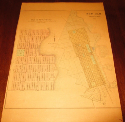
$5.00 Shipping Location: Fort Lauderdale, United States This Auction is for a LARGE unframed AUTHORIZED REPRINT of an Antique map as detailed below. This map is reproduced on specially coated. Matte finish, ... morepaper for sharper print quality and colors that are vivid. These maps are created from VERY high resolution uncompressed TIFF files(averaging 200+ megabytes) and are much sharper that the image shown here. Description of Original Bird's eye view of New Ulm. Brown County, Minnesota 1870. Approximate Image Size 16.5 X 20.5 inches WE HAVE MANY HISTORIC REPRINT MAPS AND OTHER ITEMS ON MANY DIFFERENT SUBJECTS Please check out strore for additonal products ON MULTIBLE ITEM ORDERS-SHIPPING IS FREE TO ADDRESSES IN THE UNITED STATES BY MAIL(GENERALLY 2 TO 5 DAY DELIVERY) FOR ANY NUMBER OF MAPS SHIPPED IN THE US. SHIPPING IS $15 PLUS $1 FOR EACH ADDITIONAL MAP TO ANYWHERE ELSE IN THE WORLD. WE SHIP ALL MAPS ROLLED IN A MAILING TUBE TO PROTECT THE MAP. IF YOU ARE UNHAPPY WITH YOUR PURCHASE SIMPLY RETURN IT AND WE WILL REFUND YOUR MONEY. Ad copyright 2013 J.C. Beck All Rights Reserved Powered by The free listing tool. List your items fast and easy and manage your active items.
Buy It Now
$3.25 Shipping Location: Enterprise, United States 1935 CENTRAL MINNEAPOLIS, MINNESOTA - City Map 11" X 14" - United States. The Nature of Prints & Engravings : It was not until the 20th century that prints ... morewere commonly produced for the print itself.
Buy It Now
Free Shipping Location: Schertz, United States The map is not " new " or in " new " condition & was printed in 1897. It is not dated.
Buy It Now
$12.00 Shipping Location: Denver, United States In the monograph series alone, major studies of six different iron-bearing districts in these two states, all of world class size, were published during ... morea 12-year period from 1892 to 1904. th century period.
Buy It Now
$4.95 Shipping Location: Willow Grove, United States This is an ORIGINAL Minnesota map taken from a 1906 atlas. There is a partial map image on the reverse side of this map page.
Buy It Now
$4.99 Shipping Location: Fairview, United States Stieler's Hand Atlas, published in Gotha by Justus Perthes. The publisher is stated in the bottom center, the title of the atlas is in the upper right ... morecorner and the printing details in the bottom left margin.
Buy It Now
$9.94 Shipping Location: Rosemount, United States I have years 1992- 2019 (EXCEPT YEARS 1998, 2001, 2002 and 2004).
Buy It Now
Free Shipping Location: Schertz, United States This Map was removed from an 1895 Rand McNally Atlas and is in very good condition. This map in not new or in new condition. It was printed in 1895. Including ... moreHundreds of RareCivil War. Study the photos carefully, this is the actual map you will receive.
Buy It Now
Free Shipping Location: Monroeville, United States Date - 1885. Source - Harper’s School Geography Atlas. Condition - Very Nice.
Buy It Now
$5.00 Shipping Location: Canada DATE OF ISSUE: 1911. ORIGIN OF THE MAP: "Stieler's Atlas of Modern Geography", published in Gotha, Germany by Justus Perthes.

Buy It Now
$4.50 Shipping Location: Anderson, United States The Historical Archive Sample Page Atlas of Indian Land Cessions In the United States 67 Rare Historical Maps This CD contains 67 rare antique maps of ... moreIndian Land Cessions in the United States in MrSid format. This format allows you to see the entire map on your computer screen or drill down to see the smallest details. The original maps are often quite large. As much as 36" long or larger and quite detailed. With the MrSID software, you can manipulate the map to print the entire map in great detail or zoom into a portion of the map in full detail for viewing or printing. You could even bring the images to a local print shop to have the maps reprinted in their full size. MrSID software is included on the CD. To give you a sample of the detail you can expect in these maps. Here is an example based on a panoramic map of Washington, DC. The table below shows the description and a small image of each map on this incredible history CD. Alabama Alabama(northern portion) Arizona 1 Arizona 2 Arkansas 1 Arkansas 2 California 1 California 2 Colorado 1 Colorado 2 Dakota 1 Dakota 2 Dakota 3 Florida Georgia Idaho Illinois 1 Illinois 2 Indiana Indiana(detail) Indian Territory 1 Indian Territory 2 Indian Territory 3 Iowa 1 Iowa 2 Kansas 1 Kansas 2 Louisiana Michigan 1 Michigan 2 Michigan(Saginaw bay to Lake Erie) Michigan(region about Mackinac and Detroit) Minnesota 1 Minnesota 2 Minnesota(northern portion) Mississippi Missouri 1 Missouri 2 Montana 1 Montana 2 Nebraska Nebraska(eastern portion) Nevada New Mexico 1 New Mexico 2 New Mexico and Texas(detail) New York North Carolina Ohio Ohio(detail) Oregon 1 Oregon 2 Pennsylvania Tennessee and bordering States Tennessee(detail) Tennessee and Alabama(portions of) Texas(portion of) Utah 1 Utah 2 Washington 1 Washington 2 Washington(along Admiralty inlet) Washington(northwestern) Wisconsin 1 Wisconsin 2 Wyoming 1 Wyoming 2 This is a must have collection for any historic map or American Indian history buff! To use this software. You must install the free ExpressView Mr
|
|
|
In
|