-
Christian Collectibles
-
Christian Sheet Music
-
Vatican Stamps
-
Vatican Coins & Paper Money
-
Antiques
-
Antiquities
-
Architectural & Garden
-
Decorative Arts
-
Ethnographic
-
Furniture
-
Maps, Atlases & Globes
-
United States (Pre-1900)
-
United States (1900-Now)
-
AK, HI
-
AL, FL, GA, MS, NC, SC
-
AR, IA, KS, LA, MO, NE
-
AZ, CA, CO, NM, NV, UT
-
CT, MA, ME, NH, RI, VT
-
DC, DE, MD, NJ, NY, PA
-
ID, OR, WA
-
IL, IN, MI, OH, WI
-
MN, MT, ND, SD, WY
-
OK, TX
-
VA, WV, KY, TN
-
Entire US
-
United States (Date Unknown)
-
Africa
-
Asia
-
Australasia/ Oceania
-
Canada
-
Central America/ Caribbean
-
Europe
-
India
-
Ireland
-
Mexico
-
Middle East
-
North America
-
South America
-
United Kingdom
-
Maps on CD
-
World Maps
-
Globes
-
Mixed Lots
-
Reproductions
-
Price Guides & Publications
-
Other
|
In
Order by: Available to: This site contains affiliate links for which I may be compensated
|
Buy It Now
Free Shipping Location: Lehi, United States This product is a vintage reproduction of a world map by Henricus Hondius, framed in a 12x9 inch frame. The map is designed to be used as a mirror, but ... morehas one scratch. The map shows the entire world and is categorized under World Maps, Maps, Atlases & Globes, and Antiques.
Buy It Now
Free Shipping Location: NORWICH, United Kingdom Rigobert Bonne. "L'Ancien Monde et le Nouveau en Deux Hemispheres" From Bonne's Atlas de toutes les parties connues du Globe Terrestre. Paris, 1780. Size: ... more8.4 x 12.5 inches; 21.3 x 31.8 cm Engraving. Attractive double hemisphere world map. In North America, the United States is named and confined along the eastern seaboard. The entire western region is blank with the only place name being Cape Mendocino. There is a large group of islands in the North Pacific including Alaschka in the vicinity of Alaska. Tasmania is attached to Australia and both islands of New Zealand are depicted. Light stain to lower margin into image. Edge wear. Multiple folds (one as issued).
Buy It Now
$22.00 Shipping Location: San Francisco, United States
Buy It Now
$8.70 Shipping Location: Inglewood, United States Whether you're an astronomy enthusiast or simply looking for a unique piece to add to your collection, this celestial globe is sure to impress.
Buy It Now
$4.55 Shipping Location: Oakland, United States This antique Rand McNally map from 1884 features the Canadian provinces of Nova Scotia and New Brunswick. Measuring 10x7 inches, the map is a beautiful ... moreaddition to any collection of maps, atlases, or globes. The intricate detailing and vibrant colors of the map make it a wonderful conversation piece.Perfect for collectors of antique maps or those interested in the rich history of Canada, this map is a must-have. The map provides a fascinating glimpse into the past, showcasing the development of the provinces over time. Don't miss out on the opportunity to own this unique piece of history.
Buy It Now
Free Shipping Location: Schertz, United States This antique map features the New Mexico Territory and was created by George Cram in 1884. The map measures 11x13 inches and has original hand coloring. ... moreIt is a genuine antique original, and perfect for any collector of maps, atlases, or globes. The cartographer/publisher, George Cram, is well known for his detailed and accurate maps of North America. Free shipping and handling is available within the USA, and calculated shipping and handling is available worldwide. Add this piece of history to your collection today!
Buy It Now
Free Shipping Location: San Antonio, United States This 1873 map of Indiana is an authentic national atlas map measuring 14x17 inches. It features all original colors and was published by O.W. Gray. The ... moremap is suitable to be framed and is an antique original. The map depicts the state of Indiana in great detail and is a valuable addition to any collection of North America maps, maps, atlases & globes, or antiques. It is in excellent condition and comes with free shipping and handling. Don't miss out on the opportunity to own this piece of American cartography history.
Buy It Now
$12.00 Shipping Location: Moretown, United States This antique original Mitchell Augustus atlas map depicts the Southwest United States, specifically the counties and townships of Arizona and New Mexico ... moreTerritories in 1880. The map is a county map format and is a unique addition to any collection of North America maps or antiques. The cartographer/publisher, Mitchell Augustus, is known for his attention to detail and accurate representations of geographic areas. The map would make a great display piece for any enthusiast of maps, atlases, and globes. The date range of 1880 makes it a rare find and the fact that it is an antique original adds to its value. Don't miss the opportunity to own a piece of history and add this beautiful Mitchell atlas map to your collection.
Buy It Now
$4.55 Shipping Location: Oakland, United States This antique map, measuring 11x15 inches, showcases the beautiful city of St. Louis, Missouri in 1914. It is a perfect addition to any collection of city ... moremaps or historical memorabilia. The intricate details and vibrant colors make it a striking decoration for any room.This item falls under the categories of antiques, maps, atlases & globes, and North America maps. The year of 1914 is displayed prominently in the aspects section, highlighting its historical significance. Whether you are a collector or just appreciate the beauty of vintage maps, this piece is sure to impress.
Buy It Now
Free Shipping Location: Schertz, United States This antique original map page of Kansas from 1917 and is a great addition to any collection of North America maps, maps, atlases, and globes. The colors ... moreon the map page are all original, and it was published by Geo. A. Ogle & Co. The map page was printed in 1917. This map page is perfect for collectors or anyone who wants to add a touch of history to their decor.
Buy It Now
Free Shipping Location: Schertz, United States This antique original plat atlas map of Greensburg, Kiowa County, Kansas was printed in 1887 by Everett & Stewart. Measuring at 17x28, it is a township ... moremap that depicts the area during that year. It belongs to the category of North America Maps, Maps, Atlases & Globes, and Antiques. The shipping and handling for this item is free for the USA while it is calculated for other parts of the world. This map page is a great addition to any collector's assortment of historic items.
Buy It Now
$4.55 Shipping Location: Oakland, United States This beautiful antique map of North America from 1873 is a rare find for any collector or enthusiast of cartography. Measuring approximately 13x11 inches, ... morethe vibrant colors and intricate details on this map make it a stunning piece of art. The map depicts all the US states in three different regions and is classified under the categories of North America Maps, Maps, Atlases & Globes, and Antiques. The map is a world atlas type, and features different aspects such as US State and Year. The US States are classified into three regions, AZ, CA, CO, NM, NV, UT; AL, FL, GA, MS, NC, SC; AR, IA, KS, LA, MO, NE. The map dates back to 1873, making it an excellent addition to any antique collection.
Buy It Now
Free Shipping Location: Schertz, United States Explore the extraordinary details of this 1846 antique original map of the United States with territories west of Missouri, Arkansas & Illinois, A copper ... moreplate atlas map engraved by George Washington Boynton. Immerse yourself in the rich history of the United States of America with this exquisite piece of cartography, featuring original hand coloring and intricate printing techniques. This North America map, measuring 9x11, is a rare find for collectors and enthusiasts alike. Enjoy free shipping and handling within the USA, with calculated shipping and handling available worldwide. Add this remarkable piece to your collection of maps, atlases, and globes, and discover the beauty of the United States in a whole new light.
Buy It Now
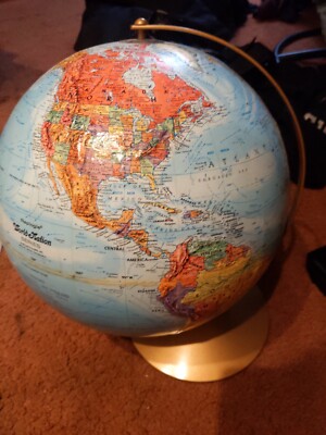
Location: Osprey, United States This vintage 12-inch World Classic Series Globe by Replogle is a beautiful piece for any collector or lover of antique decor. With a wooden base and brass ... moredetails, it adds a touch of elegance to any room. The globe features countries and continents in multi-colors, making for a striking display. The globe's type is world, with an unknown date of manufacture. It is an original vintage piece, and the cartographer/publisher is Replogle. Measuring at 12 inches in diameter, it falls under the category of Antiques and Maps, Atlases & Globes, specifically World & Celestial Globes. This globe is a perfect addition to any vintage or antique collection and will make a statement in any room.
Buy It Now
$12.45 Shipping Location: Gloversville, United States This is a rare and valuable antique original map of New York State, produced in 1919 by the National Survey Co. The map is in a folding format and is ... morea great piece for collectors of vintage maps and cartography enthusiasts. It features intricate details and accurate depictions of the state's geography and topography, making it a valuable resource for historians and researchers alike.The map is classified under the categories of Antiques and Maps, Atlases & Globes, specifically North America Maps. It is a one-of-a-kind item, highly sought after by collectors, and is in excellent condition. It would make a great addition to any collection or a unique decoration for a home or office. Smoke and pet free household. We combine shipping on multiple orders!!!
Buy It Now
Free Shipping Location: Training Battalian S.O, India 18" Big Modern Map Atlas World Globe With Wooden Tripod Stand Globe Floor Decor. WORLD GLOBE WITH FLOOR WOODEN TRIPOD STAND. ADJUSTABLE TRIPOD STAND. ... moreTRIPOD COLOR : AS SHOWN. GLOBE COLOR : AS SHOWN. MATERIAL : ALUMINUM / PLASTIC / WOOD.
$25.00 Shipping Location: Perugia, Italy The Earliest Map of Los Angeles & Santa Barbara Region.
Buy It Now
Free Shipping Location: Schertz, United States Explore the historical geography of the United States of America with this authentic 1884 map from Rand McNally & Co. Measuring 15x21 inches, this antique ... moreoriginal lithography print features the states of Virginia and West Virginia in stunning detail. The map is a true piece of art, perfect for collectors of North America maps, maps, atlases & globes, and antiques. This item includes free shipping and handling within the USA, and calculated shipping and handling worldwide. Don't miss out on this unique opportunity to own a piece of American history. Add this 1884 Virginia-West Virginia Atlas Map to your collection today!
Buy It Now
$4.55 Shipping Location: Oakland, United States This vintage map features the city of Baltimore, Maryland as it was in 1907. Measuring 15.5 x 11 inches, it is a beautiful representation of the city ... moreduring that time period. The map is an atlas format and was part of an encyclopedic atlas collection. The map is a great addition to any collection of North American maps, maps, atlases, and globes, or antiques. It is a unique piece of history that captures the city of Baltimore in a specific moment in time. The map includes important aspects such as the city's streets, buildings, and landmarks, making it a valuable resource for historical research or decorative purposes.
Free Shipping Location: Schertz, United States This antique original township map of Albany, Lee Twp., Athens Co., Ohio is a unique piece of history from 1875. The map page was printed in that year ... moreand features all original colors, giving it an authentic and charming appearance. Measuring at 14x16 inches, it is a perfect addition to any collection of North American Maps, Maps, Atlases & Globes or Antiques. The cartographer/publisher of this plat atlas map was D. J. Lake / Titus, Simmons & Titus. With free S&H in the USA and calculated S&H worldwide. This is an excellent opportunity to own a piece of history that depicts the past of Athens County, Ohio in great detail.
Buy It Now
$12.00 Shipping Location: Moretown, United States Very suitable for framing.
Buy It Now
Free Shipping Location: Prescott Valley, United States This vintage map showcases the town of Lewisboro, NY as it appeared in 1867, part of the FW Beers Atlas of NY and Vicinity. It was created by the renowned ... morecartographer and publisher F.W. Beers and is an antique original that captures the essence of the city and its surroundings. The map is a city map and is in the format of an atlas map. The map is a wonderful piece of history that highlights the city's unique features and landmarks. It is a rare find that maps enthusiasts and collectors will cherish for many years to come. This map belongs to the categories of North America Maps, Maps, Atlases & Globes, and Antiques. Its condition is outstanding, and it is a must-have for any serious map collector.
Buy It Now
Free Shipping Location: Schertz, United States This authentic 1875 map of York Township, Ohio, published by H. H. Hardesty, is a stunning piece of history. Measuring 14x19 inches, the map is suitable ... morefor framing and is an antique original. The colors are original to the piece and showcase the beautiful craftsmanship of the cartographer. The map features important aspects such as the US state of Ohio and the United States of America. It also includes the publication year, printing technique, and format. This rare piece is perfect for collectors of North America maps, maps, atlases, and globes, and antiques. Add this piece of history to your collection today!
Buy It Now
Free Shipping Location: Schertz, United States This antique original map page was printed by E.J. Chamberland / W.R. Brink & Co. in 1875. Measuring at 14x17, it features Township 4 South / Range 10 ... moreWest of Monroe County, Illinois. The map is a Plat Atlas Map that presents the area in all colors that are original. The map is a valuable addition to any North America Maps, Maps, Atlases & Globes, or Antiques collection. It is a great reference for history buffs and researchers who are interested in the region's development. The map's details are a testament to the craftsmanship of cartographers and publishers of the past.
Buy It Now
Free Shipping Location: Schertz, United States This antique original atlas map from 1875 features the Royalton and Fulton townships in Ohio. The lithography printing technique and original colors give ... morethis 14x19 map a unique and charming quality, perfect for framing and displaying. The cartographer/publisher, H. H. Hardesty, is known for his detailed and accurate maps. This piece is a great addition to any collection of North American maps, maps, atlases, and globes, or antiques.
Buy It Now
$12.85 Shipping Location: Kelseyville, United States
Buy It Now
Free Shipping Location: Schertz, United States This antique original 1887 plat atlas map features Canada, Lincolnville, and Florence in Kansas. The map page was printed by Everett & Stewart and is ... morein excellent vintage condition. Measuring 14x17 inches, this township map is a great addition to any collection of North America maps, maps, atlases & globes, and antiques. Free shipping is available in the USA, and worldwide shipping is calculated. Don't miss your chance to own a piece of history with this beautiful map.
Buy It Now
Free Shipping Location: Schertz, United States This antique original map of Baltimore, Maryland was published in 1876 by O.W. Gray. Measuring 14x17 inches, it is a great addition to any collection ... moreof North American maps, atlases, and globes. The map features Baltimore City. The publication year of 1876 adds to the historical significance of this map. It has been well-preserved and is in excellent condition. Free shipping is available for buyers within the United States, while calculated international shipping is available for those outside of the US. Don't miss out on the opportunity to own this beautiful piece of cartographic history!
Buy It Now
$29.65 Shipping Location: Reidsville, United States This vintage Rand McNally World Portrait Globe is a beautiful mid-century modern piece that showcases the world in stunning detail. With a diameter of ... more12 inches, it features raised relief and a rotating base for easy viewing. The globe is from the 1970s and is colored in a rich blue hue, making it a perfect addition to any collection of antiques, maps, atlases, or globes. The globe is a vintage original and does not come with any California Prop 65 warning. It's a unique piece that depicts the world as it was in the 1970s, making it a great conversation starter. It's perfect for display in your home or office, and its intricate details are sure to impress. Add this to your collection today and enjoy a piece of history.
Buy It Now
Free Shipping Location: Training Battalian S.O, India This smart globe is fit for kids and adults of all ages and can be used for office decor, astronomy and geography classrooms, kids educational toys, and ... moremuch more. While geographic globes are perfect for teaching kids as young as kindergarten age, they’re also a great tool for teaching students as they grow older about global political & geographical issues that arise throughout the world.
Buy It Now
Free Shipping Location: Training Battalian S.O, India This is a Reproduction Item, Not Sold As Antique. Color : Red (As Shown). Good Piece Of Collection. Look Photos For Actual Image Of Product. All Work ... moreis Hand Made. Best for gift. Material : Aluminum, Plastic.
Buy It Now
$22.19 Shipping Location: Jenkintown, United States Item For Sale Please read my terms below before buying! This item for sale is a vintage 12" diameter World Globe by Replogle Land and Sea. It is ... morein good used shape as shown in the picture with some nicks and scuffs(has a cardboard corner starting to peel on one section) Check out my other antiques for sale and combine to save on shipping! click image to supersize! Payment Information· I accept Paypal as payment. Though please inquire about other payment methods available. Paypal payments must be received within 7 days from purchase date. So please let me know if their will be a delay with your payment. If after 4 days from the purchase date. I haven't heard from the buyer and their has been no payment, I will file a non-paying buyer claim and re-list the item. Shipping Costs& Time· All items are shipped from Canada by Canada Post's shipping services and costs displayed are for the most affordable shipping method to your Country. Please ask if you require a faster shipping service and I will send you costs for other options. Though I only use Canada Post services. I will combine purchases so feel free to browse my other items for sale and combine to save on shipping. I normally ship twice a week so your item will be sent within 3 days from when payment is received Please allow this in addition to the delivery time estimates below. For your package to arrive: Shipments within Canada: Expedited(includes up to $100 insurance and full tracking) takes approximately 1 week to arrive. Economy(Light Packet shipped in a bubble mailer envelope) takes approximately 1 week to arrive. Shipments to the USA: Expedited(includes up to $100 insurance and delivery confirmation) up to 2 weeks to arrive. Standard(Small Packet Air) up to 2 weeks to arrive. Economy(Light Packet shipped in a bubble mailer) up to 2 weeks to arrive. International& Overseas Shipments: Standard(Small Packet Air) 4-6 weeks to arrive depending on destination country. Economy(Light Packet shipped in a bubble mailer) 4-6 weeks to
Buy It Now
Free Shipping Location: Schertz, United States Discover the beauty of Mexico with this antique original map from 1889. Lithography was used to create this masterpiece, which highlights the country's ... moreintricate details and features. The map was created by cartographer and publisher George Cram, known for his exceptional work in the field. This 17x23 map is a great addition to any collection of North America maps, maps, atlases, and globes. Those interested in purchasing should note that free shipping and handling is available within the USA, while calculated S&H is provided worldwide. Don't miss the opportunity to own a piece of history with this stunning antique map of Mexico.
Free Shipping Location: Schertz, United States This antique original plat atlas map of Athens County, Ohio was printed in 1875 and features townships in all their original colors. Measuring 14x16, ... morethis map was published by D.J. Lake and Titus, Simmons & Titus. The map is in excellent condition and is a must-have for any collector of North America maps, maps, atlases & globes, or antiques. Free shipping is available within the USA, while calculated shipping is available worldwide. Get your hands on this stunning piece of history today!
Buy It Now
Free Shipping Location: Schertz, United States This antique map page of the United States was printed in 1876 and features geological and climatological details. Measuring 14x16 inches, it is an original ... morepiece from the era and a great addition to any collection of North American maps, atlases, and globes. The book cover is not included and is only shown for reference purposes. The map is in excellent shape and has been well preserved over the years. A must-have for any serious collector, this antique original is a unique piece of history that tells the story of the United States and its geological and climatological makeup.
Buy It Now
$4.13 Shipping Location: Canyon Country, United States This antique map depicts the chronological history of the Civil War battlefields that took place from 1861-1865.
Buy It Now
Free Shipping Location: Schertz, United States This antique original state map from 1874 features Oregon and the Northwest territories of Washington and Alaska. Measuring at 14x17 inches, this atlas ... moremap was printed by H.H. Loyd & Co. and published by Warner & Beers Publishers. The map is in its original condition, with all colors being original and authentic. This item is a great addition to any collection of North America maps, maps, atlases, and globes, or antiques. Free shipping is available within the USA, and shipping costs worldwide will be calculated. Invest in a piece of history today with this stunning 1874 map.
Buy It Now
Free Shipping Location: Oldtown, United States This antique map of the City of Cumberland, Allegany County, Maryland from October 1968 is a rare find for collectors and enthusiasts alike. It features ... moredetailed information about the city's layout and landmarks, as well as its roads and infrastructure during the late 1960s. The map is presented in a sheet format and is an original piece from this era, making it a unique addition to any collection.The map is ideal for those interested in North America maps and maps, atlases, and globes. Its historical significance adds to its appeal for antique enthusiasts. The map is categorized under North America Maps, Maps, Atlases & Globes, and Antiques. Don't miss out on the chance to own this piece of history!
Buy It Now
Free Shipping Location: Training Battalian S.O, India 18" Big Modern Map Atlas World Globe With Wooden Tripod Stand Globe Floor Decor. WORLD GLOBE WITH FLOOR WOODEN TRIPOD STAND. ADJUSTABLE TRIPOD STAND. ... moreTRIPOD COLOR : AS SHOWN. GLOBE COLOR : AS SHOWN. MATERIAL : ALUMINUM / PLASTIC / WOOD.
Buy It Now
Free Shipping Location: Training Battalian S.O, India Nautical 16" World Globe With Wooden Floor Tripod Stand Antique Style Decor NEW. WORLD GLOBE WITH ADJUSTABLE FLOOR TEAK WOODEN TRIPOD STAND. ADJUSTABLE ... moreTRIPOD STAND. TRIPOD COLOR : AS SHOWN. GLOBE COLOR : AS SHOWN.
Buy It Now
Free Shipping Location: Jamestown, United States
$44.99 Shipping Location: Ivanhoe, Australia Wyld's Military Map Of The United States, The Northern States, And The Southern Confederate States: With The Forts, Harbours, Arsenals And Military Positions. ... moreWyld was particularly masterful at capturing political events throughout the world as they happened and leveraging his impressive publishing operation to quickly produce and distribute pertinent to the invested public.
Buy It Now
Free Shipping Location: Oklahoma City, United States This is a stunning beige imperial world globe from the George Cram Co Inc, featuring an intricate visual Geography design and a beautiful gold stand.
Buy It Now
$44.99 Shipping Location: Ivanhoe, Australia Date: - 1613. Rumold, in particular, was responsible for the complete edition in 1595. After a second complete edition in 1602, the map plates were bought ... morein 1604 by Jodocus Hondius who, with his sons, Jodocus II and Henricus, published enlarged editions which dominated the map market for the following twenty to thirty years.

Buy It Now
$25.00 Shipping Location: Belvedere Tiburon, United States This is an exquisite full-color Reproduction printed on heavyweight(7.0 MIL) Glossy Photo Paper. These maps are perfect for framing. Or a wonderful and ... moreunique gift for family members, friends or co-workers! All Information is Carefully Compiled from Actual Surveys Original Maps are often difficult to find and usually have fold lines. Identifying stamps or markings, tears, ragged edges, and assorted other natural signs of age that detract from their beauty. All of our maps have been professionally restored to depict their original beauty, while keeping all historical data intact. These maps are fabulous pieces of history full of information useful to Historians. Genealogists, Cartographers, Relic Hunters, Others. They make fascinating conversation pieces and splendid works of art for the home or office. This historic map captures history through a unique perspective. Event maps are authentic records of battles fought throughout the history of American wars. Dating back to the French& Indian War and recorded through the eyes of the noble military men themselves. They would make an excellent addition to any history buff's collection. Map Size: 23.00 x 27.56 Site Specifics To This Map Are: Arundel. Petersburg, Albany, Boston, Plymouth, Woodstock, Danbury, Harlem, Newcastle, Canterbury, and several other cities and towns throughout eastern North America. The following towns are featured: Province of New Hampshire. Part of New York, Colony of Connecticut, Province of Massachusets, Eastern Part of Massachusets, Rhode Island, Long Island, Hudson River, Connecticut River, Kusumpe Pond, Sunape Pond, and Lake George. Also Features a close-up insert of the town of Boston. This Map is Situated in: Eastern United States SKU: REWA0107 and Powered By: `0d.RcmdId ViewItemDescV4,RlogId p4%60bo7%60jtb9%3Fuk.rp*fc%3E%3E%600d-13deb7fd3e6-0xf7-
Buy It Now
Free Shipping Location: Schertz, United States This antique atlas map was printed in 1846 and features France, Spain, Portugal, Italy, Corsica, Sardinia, and Sicily. The lithography printing technique ... morewas used to create this piece, and all colors are original. The map page measures 9" x 11" and was published by S. A. Mitchell / Thomas Cowperthwait & Co. This is an antique original, not a reproduction. In addition to free shipping within the USA, shipping costs will be calculated for worldwide orders. This map will make a great addition to any collection and is perfect for those interested in North American maps, antique maps, or maps, atlases, and globes in general.
Buy It Now
$24.10 Shipping Location: Haverhill, United States This vintage reproduction pull down map page from Denoyer-Geppert highlights the Eastern Seaboard during the Revolutionary War of 1775-1783. It features ... moremultiple cities and is a great addition to any collection of antiques, maps, atlases, and globes. The political map is perfect for history enthusiasts and collectors alike. See photos.Inventory Control - G127 JN2.5# 52 4 4
Buy It Now
Free Shipping Location: Schertz, United States This antique map from 1889 features the city of Baltimore, Maryland. Measuring at 12x17 inches, it is a great addition to any collection of North American ... moremaps, atlases, and globes. The lithography printing technique used by cartographer/publisher George Cram captures the city's details beautifully. This antique original is in good condition and comes with free shipping and handling within the USA. For international buyers, shipping and handling will be calculated. Don't miss the chance to own a piece of history with this stunning Baltimore map.
Buy It Now
Free Shipping Location: Schertz, United States This antique original 1874 plat atlas lithography map features the Third Ward and Second Ward of Akron, Ohio. Measuring approximately 14" x 17", this ... moremap page was printed by Tackabury, Mead & Moffett. The US state of Ohio is highlighted on this North America map and it is a perfect addition to any collection of maps, atlases, and globes. Free shipping is available for customers within the USA, while calculated shipping is available worldwide.
Buy It Now
$12.70 Shipping Location: Millington, United States
Buy It Now
$4.55 Shipping Location: Oakland, United States This antique map of Wisconsin, produced by Rand McNally in 1884, is a beautiful and unique piece for any collector of maps, atlases, and globes. Measuring ... more10x7 inches, it is a rare find and a true gem for those interested in the history of cartography.Featuring the state of Wisconsin in stunning detail, this map is perfect for anyone looking to add an authentic piece of history to their collection. Whether you're from Wisconsin or simply love antique maps, this Rand McNally 1884 map is sure to impress.
Buy It Now
$44.99 Shipping Location: Ivanhoe, Australia Wyld's Military Map Of The United States, The Northern States, And The Southern Confederate States: With The Forts, Harbours, Arsenals And Military Positions. ... moreWyld was particularly masterful at capturing political events throughout the world as they happened and leveraging his impressive publishing operation to quickly produce and distribute pertinent to the invested public.
Buy It Now
$9.30 Shipping Location: Freehold, United States Age 9 & 10 : Back with Western Hemisphere of the Globe. Dated 1877. Title of Book was Combination Atlas of Howard County Indiana.
Buy It Now
$34.89 Shipping Location: Buford, United States This vintage pull down map from Nystrom features a world view with a focus on the United States of America. Measuring 65 inches by 60 inches, this map ... moreis a perfect addition to any learning environment or collector's space. The map is from the year 1990 and is a vintage original. Designed in a pull down format, this map is easy to store and display. The cartographer/publisher is Nystrom, a renowned name in the field of maps and atlases. This map falls under the categories of Antiques, Maps, Atlases & Globes, and North America Maps. With its unique features and excellent condition, this pull down map is a great investment for any map enthusiast.
Buy It Now
Free Shipping Location: Schertz, United States This antique original 1874 Plat Atlas Map features ASHLAND County, Ohio. The lithography print technique and the size of approximately 14" x 17" make ... morethis map page a rare find for collectors. The cartographer/publisher J.A. Caldwell is known for producing high-quality maps that have stood the test of time. This map page was printed in 1874 and is in excellent condition. The free shipping and handling offer is valid for customers in the USA, and calculated shipping is available worldwide. This map page is a great addition to any collection of North America Maps, Maps, Atlases & Globes, or antiques. Don't miss the opportunity to own a piece of history with this unique and valuable map page.
Buy It Now
$4.55 Shipping Location: Oakland, United States This antique map by Hammond features the state of Indiana and was created in the year 1908. Measuring 6x8 inches, it is a great addition to any collection ... moreof maps, atlases, or globes. With intricate details and beautiful craftsmanship, this piece is a true masterpiece of cartography. Whether you are a collector or simply appreciate the artistry of antique maps, this piece is sure to impress.
Buy It Now
$1.65 Shipping Location: Camp Lejeune, United States The map has a unique historic charm and would be a wonderful addition to any antique or map collection. The map is perfect for display or reference and ... morewould make a great conversation piece.
Buy It Now
$4.55 Shipping Location: Oakland, United States This antique map of Kansas, published in 1899 by Rand McNally & Co., is a beautiful piece of history that any collector would be proud to own. The intricate ... moredetails and vibrant colors capture the essence of the state and make it a unique addition to any collection. Measuring 7x6 inches, it's the perfect size for display in a home or office.The map features important aspects such as the US State of Kansas, the year of its publication, and the publisher, Rand McNally & Co. It falls under the categories of Antiques, Maps, Atlases & Globes, and North America Maps. This is a must-have for any antique map collector or anyone interested in the history of Kansas.
Buy It Now
Free Shipping Location: Training Battalian S.O, India Globe Color : As Shown In Picture. Material : Aluminum, Plastic And Wood.
Buy It Now
Free Shipping Location: Fairfield, United States The materials used in crafting this globe include plastic, aluminum, and wood. It's a great educational tool for schools and ideal for individuals who ... morelove decorative pieces.
|
|
|
In
|