-
Christian Collectibles
-
Christian Sheet Music
-
Vatican Stamps
-
Vatican Coins & Paper Money
-
Antiques
-
Antiquities
-
Architectural & Garden
-
Decorative Arts
-
Ethnographic
-
Furniture
-
Maps, Atlases & Globes
-
United States (Pre-1900)
-
United States (1900-Now)
-
AK, HI
-
AL, FL, GA, MS, NC, SC
-
AR, IA, KS, LA, MO, NE
-
AZ, CA, CO, NM, NV, UT
-
CT, MA, ME, NH, RI, VT
-
DC, DE, MD, NJ, NY, PA
-
ID, OR, WA
-
IL, IN, MI, OH, WI
-
MN, MT, ND, SD, WY
-
OK, TX
-
VA, WV, KY, TN
-
Entire US
-
United States (Date Unknown)
-
Africa
-
Asia
-
Australasia/ Oceania
-
Canada
-
Central America/ Caribbean
-
Europe
-
India
-
Ireland
-
Mexico
-
Middle East
-
North America
-
South America
-
United Kingdom
-
Maps on CD
-
World Maps
-
Globes
-
Mixed Lots
-
Reproductions
-
Price Guides & Publications
-
Other
|
In
Order by: Available to: This site contains affiliate links for which I may be compensated
|
Buy It Now
$17.21 Shipping Location: Austin, United States
Buy It Now
$7.00 Shipping Location: Rockville, United States Map of the State, United States and World. Compiled and published by George A. Ogle & Co., Publishers & Engravers, Chicago. I would be happy to include ... morea copy if requested. Map is generally in Good condition.
Buy It Now
$5.61 Shipping Location: Rocky Mount, United States This original 1924 Poates' Highway and Regional Guide of the United States In Three Sections: Atlantic, Mississippi Valley, contains 170 pages.
Buy It Now
$4.00 Shipping Location: Harborton, United States Neat Nevada picture map features sketches of people, vegetation, farming, animals, and more. These make fun gifts!
Free Shipping Location: Schertz, United States This Map was removed from an 1887 PEOPLES ATLAS and is in good acceptable condition. The map is not " new " or in " new " condition, it was printed in ... more1887. The map is not dated. Study the photos carefully, this is the actual map you will receive.
Buy It Now
$4.00 Shipping Location: Harborton, United States Neat Oregon picture map features sketches of people, vegetation, farming, boats, and more. These make fun gifts!
Buy It Now
$5.95 Shipping Condition: New Location: Las Vegas, United States This is a very unusual Historic Map originally Published circa 1833. “Vibrant and bright! Pic does not do it justice.looks amazing!”. The Eagle Map of ... morethe United States. Each of our prints are custom reproductions printed on 68lb Heavyweight Enhanced Matte Art Paper.
Free Shipping Location: Marana, United States This piece was removed from a 1917 Atlas and is ingood acceptable condition. Including Hundreds of RareCivil War. 100+ years of aging. Study the photos ... morecarefully, this is the actual map you. Only Authentic Originals.
Buy It Now
$4.55 Shipping Location: Oakland, United States This antique map of North America from 1869 is a rare find for collectors of historical cartography. Measuring 8.5 x 7 inches, the map features detailed ... moreborders, topography, and cities of the time period. The map is in excellent vintage condition and would make an impressive addition to any collection.The map is perfect for those interested in the history of North America or antique maps in general. Whether displayed in a home, office, or gallery, this piece is sure to spark conversations and admiration. Don't miss your chance to own a piece of history with this antique 1869 map of North America.
Buy It Now
Free Shipping Location: Schertz, United States This Map was removed from an 1887 Atlas and is in very good condition. The map is not " new " or in " new " condition, it was printed in 1887. The map ... moreis not dated. Including Hundreds of RareCivil War.
Free Shipping Location: Schertz, United States This Map was removed from an 1882 Rand McNally Atlas and is in very good condition. This map is not dated. This map in not new or in new condition. It ... morewas printed in 1882. Including Hundreds of RareCivil War.
Buy It Now
$4.55 Shipping Location: Oakland, United States This antique map from 1869 features the Western United States and measures 8.5 x 7 inches. The intricate details and historical significance make it a ... morevaluable addition to any collection of antique maps. With a focus on North America, this piece is perfect for enthusiasts of geography and history alike.
Free Shipping Location: Schertz, United States This Map was removed from a 1967 Rand McNally Atlas and is in good condition. Including Hundreds of RareCivil War. This map is not dated. This map in ... morenot new or in new condition. It was printed in 1967.
Buy It Now
$3.00 Shipping Location: Rockville, United States Map is generally in Good condition. Creases in the corners. On the reverse side is an official index showing population of states. I would be happy to ... moreinclude a copy if requested.
Buy It Now
$7.00 Shipping Location: Rockville, United States Up for sale is an original, LARGE, colored MAP OF WASHINGTON AND VICINITY, D.C. - MARYLAND - VIRGINIA. 7.5 Minute Series (Topographic). Revised 1967 Edition. ... moreOverall, the map is in Good Condition.
Buy It Now
$17.45 Shipping Location: Wellington, United States With age related wear, dust etc. Local pickup also.
Buy It Now
$7.00 Shipping Location: North Wales, United States 1886 WARREN'S SCHOOL ATLAS-HOW TO DRAW MAP OF UNITED STATES-HAND COLORED ORIGINAL ANTIQUE ATLAS MAP PLEASE SEE PHOTOS AS PART OF THE DESCRIPTION CONDITION: ... moreMAP IS IN GOOD CONDITION. SIZE: APPROXIMATELY 14" X 21" SHIPPING: U.S. FIRST CLASS RATE - $7.00 - ANY ITEM WHICH SELLS FOR OVER $100 WILL REQUIRE INSURANCE WE COMBINE SHIPPING FOR MULTIPLE WINS. THANK YOU FOR YOUR INTEREST IN OUR AUCTIONS!.
Buy It Now
$10.16 Shipping Location: Grand Rapids, United States This vintage Rand McNally thematic map features the major military installations in the United States. Measuring 21.5" x 27.5", the map is an original ... morevintage piece from the 1950s-1960s? era. The map showcases the locations and details of various military bases across the country. It is a must-have for collectors and enthusiasts of vintage maps and military history. The map is in good condition and is printed on high-quality paper. It has been well-preserved over the years and is ready to be displayed in your home or office. The map is an authentic piece of history that would make a great addition to any collection. Don't miss out on the opportunity to own this unique and rare vintage map. See pics
Buy It Now
Free Shipping Location: Schertz, United States This antique original atlas map was printed in 1894 by Frank A. Gray. It measures 17x29 inches and depicts The United States of America. The map is over ... more120 years old. The map is in its original state and does not include the title page. Shipping and handling is free in the USA, and calculated for worldwide shipping.
Buy It Now
Free Shipping Location: Grand Haven, United States On Keweenaw Point, Keweenaw County. Full color map shows the Suffolk and Bohemian Range copper mines. Reverse has text, geologic section, and cross-section., ... morein excellent condition!
Buy It Now
$6.15 Shipping Location: Cambridge, United States From "Guyot's Geographical Series" 1869 Charles Scribner and Co. Great Victorian condition with typical paper wear as seen in pics. one tear at bottom ... morein the text. Your opinion may differ. Approx 9.5 x 15".
Buy It Now
Free Shipping Location: Anaheim, United States One Regional Highway Map Sheet that is Production Folded. Bio-predation & Oxidation (aging, age discoloration mainly on the outside panels). Map Publisher: ... moreRAND-McNALLY. Map is folded. States included.
Free Shipping Location: Schertz, United States This vintage pictorial folding map titled "THE YOUNG FOURTY-NINERS - RADIO SHOW" is a unique piece of history. Printed in 1933 and designed by H. C. Holling, ... morethis novelty map features a colorful and humorous depiction of the United States during the gold rush era. The map is in its original vintage condition and is suitable for framing. All colors are original and the map is original & dated 1933. This piece is both hysterical and funny, with cartoon illustrations of the forty-niners long trip across our country. The map is 20" by 30" and is in good condition with a small tear (PHOTOS #6&7) and small tape (support) repairs on some fold lines on the back of the print. Don't miss the chance to own this exceptional piece of history.
Buy It Now
$29.60 Shipping Location: Saxapahaw, United States 1967 Reproduction of a 1858 Map of the Plantations along the Mississippi River --- Map is. I try to show everything that I can. The pictures in this ad ... moreare of the actual item you will receive. expert on everything.
Buy It Now
Free Shipping Location: Schertz, United States This piece was removed from an 1887 Atlas and is ingood acceptable condition. This original map is not "new" or in "new" condition, it was printed in ... more1887. Study the photos carefully, this is the actual map you will receive.
Buy It Now
Free Shipping Location: Augusta, United States "An Authentic Original Map Not A Reproduction".
Buy It Now
$6.50 Shipping Location: Belton, United States PR AA9 2 723, #24.
Buy It Now
Free Shipping Location: Monroeville, United States 1880 ENGRAVED ATLAS MAP OF THE UNITED STATES IN VIEW: 14.5 X 9.5 INCHES 22.5 X 17" DARK OLIVE GREEN MAT IN VIEW: LIGHT FOLD IN THE CENTER. SMALL ... moreREPAIR ON THE TOP, OTHERWISE IN GOOD CONDITION THE PHOTOGRAPHS ARE PART OF THE DESCRIPTION. We will gladly combine lots for one shipping fee. Froo www.froo.com | Froo Cross Sell. Free Cross Sell, Cross promote, eBay Marketing, eBay listing Apps, eBay Apps, eBay Application.
Buy It Now
$7.50 Shipping Location: West Palm Beach, United States John Tallis (1817-1876) was a British map publisher. FROM 1851 WRIGHTS UNIVERSAL PRONOUNCING DICTIONARY. ENGRAVINGS ARE EXCELLENT FOR HAND COLORING AND ... moreARE A PERFECT CANDIDATE FOR FRAMING OR MAKING ENLARGED PRINTS FOR UNIQUE DECOR.
Buy It Now
$5.95 Shipping Location: Bar Harbor, United States In 1861 this area (shown in the map) along with a large portion of Nebraska Territory was split off to create the organized incorporated territory of ... moreDakota. The Territory of Dakota existed from March 2, 1861, until November 2, 1889, when the final extent of the reduced territory was split and admitted to the Union as the states of North and South Dakota.
Buy It Now
$10.52 Shipping Location: Victoria, United States Thank you for shopping on my account.If you have any questions, go ahead and message me!The item you will be purchasing is:Massive Lot Of US Geological ... moreMaps USGS Topography Vintage Minnesota
Buy It Now
$137.25 Shipping Location: Detroit, United States Framed Rendition of 1875 Harpers and Brothers Map of United States Commodities. 20” X 18” See measurement
Buy It Now
$4.00 Shipping Location: Harborton, United States It is dated 1921 on the bottom right corner. This is an antique New Jersey map which was carefully removed from an atlas. ANTIQUE NEW JERSEY STATE MAP. ... moreIt is in very good condition - note light creasing and there is another map on the reverse side.
Buy It Now
$6.00 Shipping Location: Carefree, United States DATED-1916 AT LOWER RIGHT CORNER.
Free Shipping Location: Schertz, United States This Map was removed from a 1967 Rand McNally Atlas and is in good condition. Including Hundreds of RareCivil War. This map is not dated. This map in ... morenot new or in new condition. It was printed in 1967.
Buy It Now
$7.00 Shipping Location: North Wales, United States 1886 WARREN'S SCHOOL ATLAS-MAP OF UNITED STATES-INDIAN TERRITORY-HAND COLORED ORIGINAL ANTIQUE ATLAS MAP PLEASE SEE PHOTOS AS PART OF THE DESCRIPTION ... moreCONDITION: MAP IS IN GOOD CONDITION. SIZE: APPROXIMATELY 14" X 21" SHIPPING: U.S. FIRST CLASS RATE - $7.00 - ANY ITEM WHICH SELLS FOR OVER $100 WILL REQUIRE INSURANCE WE COMBINE SHIPPING FOR MULTIPLE WINS. THANK YOU FOR YOUR INTEREST IN OUR AUCTIONS!.
Buy It Now
$5.95 Shipping Condition: New Location: United States Each of our prints are custom reproductions printed on 68lb Heavyweight Enhanced Matte Art Paper. These Historic Art Prints are suitable for framing, ... moremounting or direct display on any wall! “Vibrant and bright!
Buy It Now
$8.00 Shipping Location: Saint Francis, United States Taped on back. Great shape for its age.
Buy It Now
$7.00 Shipping Location: Rockville, United States This map is from the "STANDARD ATLAS OF HARLAN COUNTY - NEBRASKA". Map of the State, United States and World. Compiled and published by George A. Ogle ... more& Co., Publishers & Engravers, Chicago. I would be happy to include a copy if requested.
Buy It Now
$4.00 Shipping Location: Harborton, United States ANTIQUE 1930'S ANIMATED OREGON STATE MAP. Neat Oregon picture map which features sketches of people, mountains, animals, vegetation, and more. These make ... morefun gifts!
Buy It Now
$6.50 Shipping Location: Belton, United States PR AA9 2 723, #23.
Buy It Now
$11.60 Shipping Location: Belton, United States Map is about 20 1/2 " wide x 28 1/8". 11 2023 Map Box 2, Folder AC, #19.

Buy It Now
$6.00 Shipping Location: Brooklyn, United States Vintage. Bevel-matted ORIGINAL map engraved for the King's Handbook of the United States in 1892. CONDITION: EXCELLENT/ VERY FINE- Clean and clear ... moreand colorful; no marks. Foxing, folds or tears, and GOOD MARGINS. A REALLY NICE IMAGE. NICE DARK LINES AND DEFINITION. This map is about 125 years old and guaranteed to be original. It’s an authentic old map from the aforementioned publication. And NOT A REPRODUCTION. The map is 4 3/4" x 7" Matted the print measures 8" x 10" This is a standard size mat that will fit into a standard size frame—no costly custom frames required. THOUSANDS OF ANTIQUE ENGRAVINGS AND LITHOGRAPHS IN OUR STORE. PLEASE TAKE A LOOK. ALL OF OUR MATTED PRINTS ARE WRAPPED IN A CLEAR CELLOPHANE ENVELOPE THAT PROTECTS THE PRINT DURING SHIPPING AND IS PERFECT FOR GIFT GIVING. About The Mats All of our prints are bevel matted in a very high quality. And simple off-white/ivory matting. The BLACK ACID FREE BACKING, WHICH IS NOT ATTACHED TO THE PRINT, but which should be kept with the print when framed, also meets the same high quality standard. We take pride in what we sell—look at our feedback. All mats are acid-free and the small piece of tape used to attach the print to the top of the mat is artists tape(which we will remove if you prefer a non-matted print- sorry no price reduction) This print is truly ready to be framed and preserved. Some Comments About Our Mats: Always a wonderful transaction. Will buy again. Awesome Prints& Mats! Incredible Print. Fab pkg. Rapid ship. Gorgeous Mat. Great communication. A+. Wonderful item.well matted.packed well. Quick delivery.aaaa service. Beautiful Print. Awesome Mat! Fab pkg. Rapid ship. Bought 4 MORE! A++++. As always. A very fine print& mat, well-packed& promptly shipped: A+. This print is better than I imagined. The mat is fabulous, everything is perfect. THANK YOU! JUST AS DESCRIBED. GREAT MATTING! A+A+A+. Great vendor. Nicely packaged and matted. Highly recommend this vendor. Great matted print. Excellent transaction in
Free Shipping Location: Schertz, United States This Map was removed from a 1967 Rand McNally Atlas and is in good condition. Including Hundreds of RareCivil War. This map is not dated. This map in ... morenot new or in new condition. It was printed in 1967.
Buy It Now
Free Shipping Location: Carefree, United States RARE ORIGINAL 1903 ANTIQUE MAP OF THE UNITED STATES SHOWING PRODUCTION OF BARLEY PER SQUARE MILE. ORIGINAL ANTIQUE 1903 MAP OF THE UNITED STATES SHOWING ... morePRODUCTION OF BARLEY PER SQUARE MILE. GOOD CONDITION, DISCOLORATION AND CENTER CREASE AS ISSUED.
Buy It Now
Free Shipping Location: Schertz, United States This Map was removed from an 1857 COLTON ATLAS and is in good acceptable condition. The map is not " new " or in " new " condition, it was printed in ... more1857. The map is dated. Study the photos carefully, this is the actual map you will receive.

Free Shipping Location: Schertz, United States This Listing is for an Unframed ORIGINAL(not a reprint) map as pictured above and detailed above. Each Page has TWO maps one on each side. Original Atlas ... moreTitle General Atlas of the World Containing Large Scale Maps of every State. Territory and Country in the World. With a carefully prepared Historical and Descriptive Sketch of each. Together with an Alphabetically Arrange List of Every Railroad Station in the United States. Canada and Mexico, Principal Cities, Lakes, Rivers, Islands and Mountain Peaks of the Entire Globe, and other Statistical Tables on all Geographical Subjects. 1889 Engraved by Rand McNally Approximate Image Size Map size is 9 X 12 inches WE HAVE MANY HISTORIC MAPS AND OTHER ITEMS ON MANY DIFFERENT SUBJECTS Please check our store for additonal products FREE SHIPPING BY MAIL(GENERALLY 2 TO 5 DAY DELIVERY) FOR ANY NUMBER OF MAPS SHIPPED IN THE US. Due to huge recent increases in international shipping costs and issues with deliverly I no longer ship outside the US. To protect it during shipment this map will be shipped rolled in a heavy tube and protected by a plastic sleeve. IF YOU ARE UNHAPPY WITH YOUR PURCHASE SIMPLY RETURN IT AND WE WILL REFUND YOUR MONEY. Ad copyright 2015 All Rights Reserved Powered by The free listing tool. List your items fast and easy and manage your active items.
Buy It Now
$5.95 Shipping Location: Newnan, United States Antique 1822 Map Of Georgia With Indian Territory Reproduction 8.5 X 11 Color. Cook County, GA. Union County, GA. Printed in full resolution on quality ... morepaper suitable for framing. Tuscaloosa County, AL.
Buy It Now
$4.00 Shipping Location: Harborton, United States Antique Alabama map which was carefully removed from an atlas published in 1917. ANTIQUE ALABAMA STATE MAP. It is in very good condition - binding holes ... morealong the left edge and there is another map on the reverse side.

Free Shipping Location: Schertz, United States This Listing is for an Unframed ORIGINAL(not a reprint) map as pictured above and detailed above. Each Page has TWO maps one on each side. Original Atlas ... moreTitle General Atlas of the World Containing Large Scale Maps of every State. Territory and Country in the World. With a carefully prepared Historical and Descriptive Sketch of each. Together with an Alphabetically Arrange List of Every Railroad Station in the United States. Canada and Mexico, Principal Cities, Lakes, Rivers, Islands and Mountain Peaks of the Entire Globe, and other Statistical Tables on all Geographical Subjects. 1889 Engraved by Rand McNally Approximate Image Size Map size is 9 X 12 inches WE HAVE MANY HISTORIC MAPS AND OTHER ITEMS ON MANY DIFFERENT SUBJECTS Please check our store for additonal products FREE SHIPPING BY MAIL(GENERALLY 2 TO 5 DAY DELIVERY) FOR ANY NUMBER OF MAPS SHIPPED IN THE US. Due to huge recent increases in international shipping costs and issues with deliverly I no longer ship outside the US. To protect it during shipment this map will be shipped rolled in a heavy tube and protected by a plastic sleeve. IF YOU ARE UNHAPPY WITH YOUR PURCHASE SIMPLY RETURN IT AND WE WILL REFUND YOUR MONEY. Ad copyright 2015 All Rights Reserved Powered by The free listing tool. List your items fast and easy and manage your active items. RcmdId ViewItemDescV4,RlogId p4%60bo7%60jtb9%3Feog4d71f%2B%3F4f%3E-14bf5002066-0x115-
Buy It Now
$4.02 Shipping Location: Highland, United States
Buy It Now
$5.00 Shipping Location: League City, United States This map has been carefully removed from the atlas it originally appeared in and is perfect for display purposes. It may have writing or other images ... moreon the reverse side of it. It is in very good condition for its age with overall tonal aging and yellowing on the edges.
Free Shipping Location: Kennebunk, United States This Map was removed from a 1898 Atlas and is in good acceptable condition. Only Authentic Originals. Study the photos carefully, this is the actual map ... moreyou.
Buy It Now
$4.88 Shipping Location: Las Cruces, United States Publisher: U.S. Geological Survey.
Buy It Now
$4.00 Shipping Location: Harborton, United States This is an antique map of Maine which was carefully removed from a George Cram atlas published in 1886. ANTIQUE MAINE STATE MAP. It is in very good condition ... more- note creasing, light age spotting and there is a partial map on the reverse side.
Buy It Now
$4.99 Shipping Location: Fairview, United States An Authentic Antique Map: Not a Modern Reproduction! Condition: It is in Good condition for its age with overall light tonal ageing, on a flexible page ... morewith hand coloring. There are a couple of slightly bent corners, damp stain along the edges and a few light smudges around the margins, see the pics for more on condition.
Buy It Now
Free Shipping Location: Augusta, United States "An Authentic Original Map Not A Reproduction".

Buy It Now
$5.95 Shipping Condition: New Location: Las Vegas, United States Map of Florida 1823 Size: 20" x 24" 51 cm x 61 cm) x Also Available in 24" x 28" from our eBay Store This is a great Classic Map originally ... morePublished circa 1823. This map by Charles Blacker Vignoles. Shows Florida and the Gulf of Mexico in the early 1800's. This poster. Which evokes the vivid images of a simpler time, is a custom reproduction printed on 68lb Heavyweight Enhanced Matte Art Paper. This Historic Art Print is suitable for framing. Mounting or direct display on any wall! 000 Artscape Galleries/ Posters Past More Prints and Posters Available from our eBay Store! Shipping price includes delivery confirmation. We combine shipping for multiple purchases- add $1.00 for each additional poster. All posters are professionally packaged to ensure that they arrive safely and undamaged: Your poster is first rolled and inserted into a plastic sleeve before being placed into a Heavy-Duty mailing tube for delivery. We stand behind the quality of every poster. If you are not satisfied with your purchase. Please contact us within 30 days to arrange for either an exchange or a full refund. gsrx_vers_468(GS 6.4(468)
Buy It Now
$116.50 Shipping Location: Herndon, United States Rare first official large format plan of Washington, DC by Andrew Ellicott. Engraved and printed by Thakara and Valance, Phila., PA. in 1792. This is ... moretruly a piece of history. Happy to provide more information.
Buy It Now
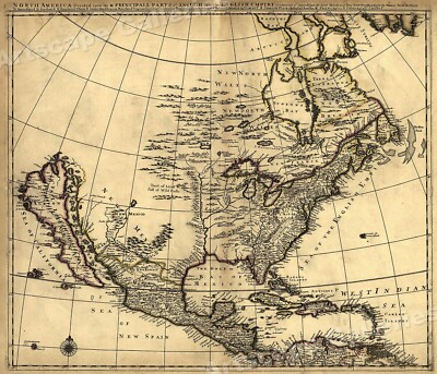
$5.95 Shipping Condition: New Location: Las Vegas, United States North America 1685 Size: 24" x 28" 61 cm x 86 cm) x Also Available in from our eBay Store This is a great Classic Map originally Published circa ... more1685. This Map shows what was known of America(North America) in1685. The wording reads: North America divided into its III principall parts. Features include: New North Wales" Canada) Bay of Mexico" Gulf of Mexico) Sea of the English Empire" Atlantic Ocean) West Indian Sea" Caribbean) Sea of California" Sea of New Spain" Pacific Ocean) New Mexico" Western United States) and"Tract of Land full of Wild Bulls" Great Plains) This poster. Which evokes the vivid images of a simpler time, is a custom reproduction printed on 68lb Heavyweight Enhanced Matte Art Paper. This Historic Art Print is suitable for framing. Mounting or direct display on any wall! 000 Artscape Galleries/ Posters Past More Prints and Posters Available from our eBay Store! Shipping price includes delivery confirmation. We combine shipping for multiple purchases- add $1.00 for each additional poster. All posters are professionally packaged to ensure that they arrive safely and undamaged: Your poster is first rolled and inserted into a plastic sleeve before being placed into a Heavy-Duty mailing tube for delivery. We stand behind the quality of every poster. If you are not satisfied with your purchase. Please contact us within 30 days to arrange for either an exchange or a full refund. gsrx_vers_468(GS 6.4(468)
|
|
|
In
|
Cram Map ...World and United States
SquareTrade © AP6.0 Cram Map.World and United States We bought a lot of fixtures from a closing school and ended up with several wall maps.this map is 65 inches wide and 80 inches tall the rollers still work so it retracts up and down etc.it has two pull down maps in very good condition Please check our Ebay store"PURPLE MOOSE LIQUIDATIONS" We want you as a life long Customer. The Moose Team Contact Payment is expected within 3 days. If you are having problems. As we sometimes do, please email us and we will try to work with you. Buyer pays all shipping and handling fees unless FREE SHIPPING for contiental US is offered. Accepted forms of payment PAYPAL,CREDIT CARDS Generally you must have a confirmed address for shipping. Buyer pays all shipping and handling fees unless otherwise noted. Please allow from three to ten days ... moreafter payment is accepted to receive your item. Every effort is made to ship ASAP. Outside of US allow extended ship time. Inspection: Once you receive your item please inspect it and make sure it is what you bid on. If you are satisfied with our service please leave approppiate feedback. If you are not happy with our product or service please contact us and we will make you happy. COMBINED SHIPPING.we will be happy to combine shippingfor multiple items(some size or weight exceptions) `Highest shipping cost 1/2 other items shipping costs All items must be paid in one transaction All items to be combined must be in 7 day period Attention International buyers.Due to restrictions on the size of boxes. There are certain countries where items over 79" Length and Girth.cannot be shipped. If you purchase an item from us that cannot be shipped we will contact you, and refund monies if need be, etc. If you would like quicker shipping we can quote it.we use UPS most of the time and USPS for International. We strive to be 100% FIVE STAR" scores from you. The Star-scores are very important to us because ebay uses them to determine our fees and our visibility in the ebay search res
|
|
|
Vintage State Bird and Flower Map of the United States-Fritz Hilton c1940-50's
Vintage State Bird and Flower Map of the United States-Fritz Hilton c1940-50's Listed for sale is a nice vintage State Bird and Flower Map of the United States. Professionally framed at some point. Measures 36 5/8" x 24 1/8" Marked Published by Barton-Cotton, Inc. of Baltimore. Executed in watercolor by Fritz Hilton. Approved by the American Museum of Natural History, and the National Audubon Society. A rare piece, very cool! gsrx_vers_486(GS 6.5.1(486)
|
|
|
1890 Color Map of the Eastern United States
Offered for sale in this listing is a 1890 Color Map of the Eastern United States Map is in good condition. Sheet has yellowed with age. Folded. Small tears along edges at folds. Chipping at bottom(bind-in) edge. Sheet measures 11 x 12.75 inches. Taken from"Chambers's Encycolpaedia" Collier Publisher, New York, 1890. Thank you for looking! Powered by The free listing tool. List your items fast and easy and manage your active items.
|
|
|
United States of America USA Rare Original Vintage 1898 Antique World Atlas Map
This beautiful colored map comes from the original 1898 Rand McNally Atlas of the World 115 years old! 100% Original and Authentic. Gorgeous map featuring the United States of America with a with an incredible amount of detail. Maps show state. Cities, railroads, rivers, islands, lakes and topography in great detail. Maps measures 14" X 11" Please see pictures for condition detail. It is ready to frame and would look great on the wall of your office or study. I g ave a couple of these as Christmas presents and they were a big hit! Will ship rolled in a tube. Free Sh ipping within the U ni ted States. I have the entire World Atlas available and as it has fallen apart I will be separating it and selling the maps individually so they can be enjoyed. If you are interested in any particular States or Countries please let me know. RcmdId ... moreViewItemDescV4,RlogId p4%60bo7%60jtb9%3Fv%7F.rpn33%3E-13d3a8a7b70-0x103-
|
|
|
Original 1869 Antique Lippincott Map US West UNITED STATES of AMERICA
Fine Adornment of American History. Impressive on Any Home or Office Wall. Imaginative& Creative Gift. 1869 Map of The Western United States Fine J.B. Lippincott Map. Warbrick& Read Engraved. Original 1869. 143-ys-old. Map is in Good condition: No marks or writings. Mild foxing. Slight fraying along edges. Single fold as Issued. Not a Reproduction. Original Map Drawn& Engraved by Warbrick& Read Expressly for the Atlas to Accompany the 1869 Edition of The William& Robert Chambers' Encyclopaedia: A Dictionary for Universal Knowledge For The People. Illustrated, Published by J.B. Lippincott& Company, New York, 1869; a copy of the Title Page of which is Included. Fine Adornment of History on Any Home or Office Wall. Exceptional Lippincott Map for the Collector or Makes Quite An Impressionable Gift. I Sell Only Original ... moreAntique Maps: No copies or reproductions. Press Here to View My Collection. Impressive on Any Home or Office Wall. Dimensions: 9.75" x 12.25" J.B. Lippincott Map. Intricate Engraved Detail. Fine Adornment of American History. The Auction is for the Map Itself. A Frame is Not Included. The Framed Map Pictured is a Personal J.B. Lippincott Map Featured to Show the Beauty of the Maps when Framed. Free Shipping Special. All Credit& Debit Cards along with Electronic Checks accepted through Paypal. Please email with any questions. Imaginative& Creative Birthday. Christmas, Graduation, or Other Special Occasion Gift. Greetings from Savannah. Georgia; founded 1733. Some. To beautify their halls, parlors, chambers, galleries, studies, or libraries.liketh, loveth, getteth, and useth maps, charts, and geographical globes. John Dee. Advisor to Elizabeth I. Press the Store Link Below to View My Collection. Powered by The free listing tool. List your items fast and easy and manage your active items.
|
|
|
1886 United States Large 2-page Color Atlas Map^ w/ Towns, Railroads, Forts, etc
1886 United States Large 2-page Color Atlas Map^ w/ Towns. Railroads, Forts, etc Gorgeous. Original, and Large 18 8 6 United States 2-page Color Map A small map of Ontario is on the back This is an ORIGINAL.NOT A REPRINT. 1 26 + year-old Undated atlas map.that UNFOLDS and measures 2 1 1/2" x 1 3 1/2" with the borders. The map shows shows the major railroads. Towns and cities, Forts, camps.also rivers, Mountains and other geographic features etc. NOTE: The map does not include roads. Great. Historic Item that has a little border and corner wear. Otherwise. It is in Nice Condition. Please see the attached photo to view the Map and some closeup sections of the map. There is a border all the way around the map.everything on the map is very clear and readable.even for a old blind guy like me* Minimum bid for this 1 2 6 year-old map is ... moreonly $1 9.95 or purchase it for $ 23.95. U.S. Buyer pays $3.00 for shipping; $4.00 shipping to Canada.$6.00 shipping to Europe. Asia and Pacific. 1-4 maps can be combined to save on shipping. PLEASE READ: This is an Original 18 8 6 Undated Atlas map. I will enclose a copy of the dated 18 8 6 copyright page for the buyer. If you have any questions about this map or any of my Ebay items.Please email me before bidding. Thanks! 1 20 8 12 USA 8 6.1( P) Please Visit My Ebay Store To View My North America. Canada, United States and Other Antique Maps. Thanks For Looking! ALL INTERNATIONAL BUYERS PLEASE READ: Please be aware that some packages going into Canada. The UK and France are taking a very long time for delivery.2-weeks in some cases. Although I mail them as quickly as I can.I have no control over how long it takes for them to be delivered after I mail them.Also, These old maps are shipped in sturdy mailing tubes and are very, very rarely lost. However, I send these via first class airmail trying to save international buyers shipping costs and, unless the international buyer is willing to spend a much higher rate to have it mailed Interna
|
|
|
1895 Map of "Territorial Growth of the United States"- Puerto Rico (on reverse)
Authentic Antique Map of the TERRITORIAL GROWTH OF THE UNITED STATES- Map of PUERTO RICO is on reverse Very unique and unusual This is an original page(not reproduction) from the Philadelphia Public Ledger's Unrivaled Atlas of the World pre pared and published especially for The Public Ledger. George W. Childs Drexel, Editor and Publisher. Each page is 11" x 14" Map Copyright. 1895. By Rand, McNally& Co. In excellent condition for a map of this age. Pictures show a couple of flaws. Pic#2 shows what appears to be a fingerprint or smudge. Pic#3 shows rough binding edge, pic#5 shows slight tear on right edge. I try to describe each map as accurately as possible. Would be nice framed for a history buff. Travel buff, or college student. A real piece of history. Makes a unique gift. If framed, you might elect to trim the binding ... moreedge) I ship my maps rolled in a mailing tube for protection. I am happy to combine shipping. Feel free to contact me with any questions. I have many maps of U.S. States and countries listed and will be listing more within the next few days/weeks. Please look at my other historic maps. Happy Bidding! 2p5ddv.RcmdId ViewItemDescV4,RlogId p4%60bo7%60jtb9%3Fuk%601d72f%2B26rk%3E2p5ddv-13d3ac7ca3e-0xfe-
|
|
|
GEOLOGICAL MAP OF THE UNITED STATES AND TERRITORIES BY ASHER AND ADAMS 1874
This is an exquisite full-color Reproduction printed on heavyweight(7.0 MIL) Glossy Photo Paper. These maps are perfect for framing. Or a wonderful and unique gift for family members, friends or co-workers! All Information is Carefully Compiled from Actual Surveys Original Maps are often difficult to find and usually have fold lines. Identifying stamps or markings, tears, ragged edges, and assorted other natural signs of age that detract from their beauty. All of our maps have been professionally restored to depict their original beauty, while keeping all historical data intact. These maps are fabulous pieces of history full of information useful to Historians. Genealogists, Cartographers, Relic Hunters, Others. They make fascinating conversation pieces and splendid works of art for the home or office. Map Size: 32.81 x 23 Site Specifics ... moreTo This Map Are: A colorful depiction of the United States showing Eozoic. Paleozoic, Carboniferons, Mesozoic, Cenozoic, Volcanic Centers, and Volcanic Rocks. The following towns are featured: Several Cities and Towns across the United States This Map is Situated in: United States of America SKU: USZZ0009 and Powered By:
|
|
|
1895 Map of the UNITED STATES 11" x 14"
Authentic Antique Map of the UNITED STATES This is an original page(not reproduction) from the Philadelphia Public Ledger's Unrivaled Atlas of the World pre pared and published especially for The Public Ledger. George W. Childs Drexel, Editor and Publisher. Each page is 11" x 14" Map Copyright. 1895. By Rand, McNally& Co. In excellent condition for a map of this age. Has a faint crease in the lower right corner. See Pic#2) Would be nice framed for a history buff. Travel buff, or college student. A real piece of history. Makes a unique gift. If framed, you might elect to trim the binding edge) I ship my maps rolled in a mailing tube for protection. I am happy to combine shipping. Feel free to contact me with any questions. I have many maps of U.S. States and countries listed and will be listing more within the next few days/weeks. ... morePlease look at my other historic maps. HAPPY BIDDING!
|
|
|
RARE 2 Sided Antique Milton Bradley DISSECTED MAP UNITED STATES & Flags Puzzle
You are buying a RARE 2 Sided Antique Milton Bradley DISSECTED MAP UNITED STATES Wooden Puzzle. Estate fresh. This wooden puzzle does NOT have the box but is complete. The colors are bright and clear with only one piece broken(both pieces of it are there) and a few smudges here and there. Has Flags of the world and Uncle Sam on the opposite side. The puzzle is approx 20" x 14 1.4" and has 66 pieces. Please e-mail any questions. Please! Please! read before bidding on my auction. Please wait to bid until you have read the ENTIRE description and looked at all the pictures. I ALWAYS include condition and measurements in the description of the item up for auction. I may use the words“small. Little, miniature, tiny” as all meaning the same thing. The same with large, big, bold, huge, etc. Consider the measurements as well as the words ... moreto see if this is what you want. Please e-mail any questions. PLEASE NOTE: Shipping& handling is always disclosed in the auction before you bid. So by bidding. You agree the amount is acceptable and warrants a 5-star feedback(DSR) rating for shipping& handling. Contact me if you have questions regarding shipping. I do not get the full amount you pay for shipping. PayPal and eBay take and keep 11% of what you pay for shipping. THANK YOU FOR VIEWING MY ITEM!
|
|
|
MITCHELL'S UNITED STATES REFERENCE & DISTANCE MAP/INDEX/CITIES-RIVERS/1838
MITCHELL'S UNITED STATES REFERENCE& DISTANCE MAP/INDEX/CITIES-RIVERS/1838 AN ACCOMPANIMENT TO MITCHELL'S REFERENCE AND DISTANCE MAP OF THE UNITED STATES; CONTAINING AN INDEX OF ALL THE COUNTIES. DISTRICTS, TOWNSHIPS, TOWNS, ETC. IN THE UNION; TOGETHER WITH AN INDEX OF THE RIVERS; BY WHICH ANY COUNTY, DISTRICT, TOWNSHIP, ETC. OR RIVER MAY BE FOUND ON THE MAP, WITHOUT DIFFICULTY. ALSO A GENERAL VIEW OF THE UNITED STATES, AND THE SEVERAL STATES AND TERRITORIES; WITH AN ACCOUNT OF THE ACTUAL AND PROSPECTIVE INTERNAL IMPROVEMENTS THROUGHOUT THE UNION. THE WHOLE, IN CONNEXION WITH THE MAP, ILLUSTRATING THE GEOGRAPHY, TOPOGRAPHY, AND STATISTICS OF THE UNION, IN A MORE COMPLETE AND SATISFACTORY MANNER THAN HAS BEEN HITHERTO ATTEMPTED. Philadelphia: Mitchell and Hinman, 1838. Scarce. A nice original edition of this scarce and interesting ... morework published to accompany a now rare map of the United States; this 324-page book contained a greater amount of useful geographical. Topographical, and statistical information of the country than any similar work of its day. Each state(plus the Missouri, Oregon and"Ouisconsin" Territories) are given several pages covering their canals and railroads, plus their stagecoach routes. Ohio, for example, has two-and-a-half pages devoted to listing its principal stage routes. This book is solid and complete and it retains the original leather binding. Published more than 170 years ago, this work is now long out of print. Such a nice book is not likely to come up for sale often on ebay. From the Preface: This'Accompaniment'is respectfully offered by the publisher to his fellow-citizens. Under the persuasion that[together with the map] they will be found to contain a greater amount of useful geographical, topographical, and statistical information, than any similar work hitherto published in the country. A principal object intended in the compilation of the Map. Is the representation of all the local and civil divisions of the different States, so arranged as to conn
|
|
|
Waukon Iowa 1908 original antique lithograph United States topographic map
Waukon Iowa 1908 original antique lithograph United States topographic map ALLUVIATION- WAUKON(IOWA-WIS. Iowa- Wisconsin- Mississippi River- Harpers Ferry& Prairie du Chien) issued Washington D.C. 1908; for the U.S. Geological Survey Fine original antique color lithograph topographical map. Printed on quality coated stock paper which retains its inherent structural flexibility and soundness. In Very Good or better condition[note: we grade very conservatively and always seek to disclose any noteworthy flaws] The printed area remains pleasing. A nice impression that would look great framed. Sheet measures c. 8 1/2" W x 11 1/8" H. Engraved area measures c. 5 3/4" W x 9" H. 35662] note: All old sheets of printed paper possibly have short edge splits. Each sheet has existed for a very long time and has probably been handled ... morerepeatedly in the course of it's existence. It has a history unique to it as an object. Most of the time any edge splits are short. Minor, insignificant and have been closed- either long ago or more recently with small pieces of archival tape. Most often these splits are trivial and easy to overlook visually. Basically, they would not significantly affect the piece adversely. The item is offered as seen. Please look carefully and make your decision knowing this antique image is nice. But it is not in perfect"like new" condition. However, with whatever flaws it possesses, it remains entirely worthy of ownership and inclusion in any related collection. We feel it will prove very pleasing to its new owner. We stand behind everything we sell. Everything we offer is guaranteed to be an authentic original antique item as described. We do not sell modern reproductions. Please visit our. We happily accept PayPal! WE OFFER FLAT RATE SHIPPING WORLD WIDE! Please request an invoice before paying for multiple items so that we can ensure that you are not overcharged for shipping! To receive our flat
|
|
|
America, North America, United States Canada very decorative map Levasseur 1856
Splendid map of North America by Levasseur measures 52 x 36 cm good condition
|
|
|
Denoyer Geppert US Westward Expansion Pull Down Map Canvas Back '67 United State
Denoyer Geppert U.S. Westward Expansion Pull Down Map Canvas Back 1967. Wonderfulcolorful graphics of the Northest coast from Maine to part of Florida as well as the Midwest. Has the timeline above the map from 1763 to 1830. Also has a little summary about the Louisiana and Florida acquisitions and other historial events. The map area measures 44x38.5 inches. The whole thing measures 44x49.5 inches. The top pole has the metal pieces on either end that would be inserted inside a holder on the chalkboard if you have one. The map itself is in very good condition. Hardly any wear and clean. There appears to be some water stain behind on the bottom of the map,directly behind the brown section, none on the map part.
|
|
|
1941 ANTIQUE WWII MAP OF NORTH AMERICA UNITED STATES / SOUTH AMERICA
1941 ANTIQUE WWII MAP OF NORTH AMERICA UNITED STATES/ SOUTH AMERICA This original antique map gives you an opportunity to examine in exquisite detail a piece of history. If you are interested in the past of this country and its people or have a desire to study where your family may have come from. Then this map gives you a rare look as the area was about 70 years ago. Once matted and framed, this map would make a perfect gift for a family member or friend they'll cherish forever. Origin of the map: The International Atlas of the World" Published by Geographical Publishing Company, Chicago, USA. Date of issue: 1941 Size: The sheet measures 14 1/4" x 10 1/4" 36 x 26 cm) STAINS ON THE MARGIN(SEE THE PHOTO) S/H: The map will be shipped by Air Mail. The shipping charge is: USA- 7.50 USD. World/ Canada- 8.50. The price includes ... morethe insurance and a strong, cardboard tube with plastic plugs. Attention! There is no additional shipping charge for multiple purchases! Pay me securely with any major credit card through PayPal! Payment methods: US/Canada Buyers: Paypal. International Buyers: Paypal. Click Here. Double your traffic. Get Vendio Gallery- Now FREE!
|
|
|
UNITED STATES CALIFORNIA ARIZONA STIELER MAP 1905
b e e b y b o o k s ORIGINAL ANTIQUE MAP TAKEN FROM STIELERS HAND-ATLAS PUBLICATION DATE 1905 CONDITION/DESCRIPTION: a good. Clean map, lightly age toned, 485 x 400mm approx including margins, vertical centre fold as issued, blank verso, perfectly suitable for framing and/or reference- please examine images. ADDITIONAL STIELER MAPS SHIP FREE. BUY 4 MAPS AND GET FREE SHIPPING. 1390934 SHIPPING UK- £2.50/ EUROPE- £3.00/ REST OF WORLD- £3.50 Items usually shipped within 2 working days. Items paid for on a Friday may not ship until the following Monday. GUARANTEE Comprehensive cover is included up to the value of £41. If insurance is required for items valued above £41. Please ask. Money back guarantee if not completely satisfied. If you have any questions. Please ask. beebybooks@googlemail.com Powered by.RcmdId ViewItemDescV4,RlogId ... morep4%60bo7%60jtb9%3Fv%7F.rpn35%3E-13d3bbe2f27-0x101-
|
|
|
CALIFORNIA South - UNITED STATES 1903 original antique map
Good quality ORIGINAL antique lithograph map Title: California- Southern part- United States" Publication& Date: issued in Edinburgh 1903 by Adam& Charles Black for" Encyclopaedia Britannica(10th edition) Description: Detailed. Interesting and decorative. Inset Los Angeles- San Diego and Yosemite National Park Condition& Size: Clean and good condition- printed area 15"x 10.5" 38x27cm) plus good margins. Full colour Postage: UK and- Europe- £2.50- Rest of World and USA- £5.00 Visit our many other interesting listings of maps& prints on our Site(rediiwi) and in our E-BAY STORE Payment: Use Paypal or ask for details Thanks for looking
|
|
|
1930 antique LRG FOLD-OUT UNITED STATES MAP~BURLINGTON ROUTE owned CHAS.GILMORE
VACATIONX] We combine shipping charges on multiple winning bids. Check out my other listings. save $$$: on eBay. 1930 antique LRG FOLD-OUT UNITED STATES MAP~BURLINGTON ROUTE owned by CHAS.GILMORE. Good condition with some splitting at folds. Measures approx 36.6 x 18.5" We combine shipping charges on multiple winning bids. Check out my other listings. save $$$: on eBay. our promise to you: 1.Our items are mostly 100 years old or so. Please don't bid if you have the expectation that they are like new. We try to describe major flaws and we add photos so you can use both the judge condition. Please don't leave us low stars or negative feedback without contacting us first to try to resolve. 2. We sometimes make mistakes in our listings. But we never intentionally misrepresent. To give you peace of mind, we offer an easy, no hassle ... morereturn policy. We have a staff of four, and an occasional mistake will happen. Please be kind with feedback as we will make it right with our return refund policy. 3.We do not offer partial refunds or"discounts" after you receive the item. We will offer full refund for return. Please be kind with feedback as we will make it right with our return refund policy. Please contact us first through ebay message system before leaving bad feedback. Often there is just a misunderstanding and we appreciate being given the opportunity to explain or make things right. It is our desire to work with you and appreciate your business and kindness. LOC: paperbox25-KM Powered by.RcmdId ViewItemDescV4,RlogId p4%60bo7%60jtb9%3Fuk.rp*73c7e%3D%3E-13d3bbe2e32-0xfd-
|
|
|
USA: The Indians in the United States to 1905, 1956 map
The Indians in the United States to 1905 Colour vintage map. Scale 1: 20.000,000, 1956 Title of map: The Indians in the United States to 1905' The image below shows an enlarged cross section from the centre of the map to show the level of printed detail: DATE PRINTED: 1956 IMAGE SIZE: Approx 15.0 x 24.5cm. 5.75 x 9.5 inches(Medium) ARTIST/CARTOGRAPHER/ENGRAVER: Unsigned PROVENANCE: Shepherd's Historical Atlas" By William R. Shepherd; Published by George Philip and Son Limited, London. 8th Edition. Please note that virtually all antique and vintage maps and prints have been extracted from books, atlases or newspapers. TYPE: Colour vintage map. Scale 1: 20.000,000. This map was published in 1956 but it may depict an earlier representation of the area shown dated 1905 and the mapmaker may have drawn on an earlier original work VERSO: ... moreThere are images and/or text printed on the reverse side of the picture. In some cases this may be visible on the picture itself(please check the scan prior to your purchase) or around the margin of the picture CONDITION: Good; suitable for framing. Please check the scan for any blemishes prior to making your purchase. Virtually all antiquarian maps and prints are subject to some normal aging due to use and time which is not obtrusive unless otherwise stated. I offer a no questions asked return policy- see below. AUTHENTICITY: This is an authentic historic print. Published at the date stated above. I do not offer reproductions. It is not a modern copy. The term'original' when applied to a print means that it was printed at the first or original date of publication; it does not imply that the item is unique. Print' means any image created by applying an inked block to paper or card under pressure by any method including wood engraving, steel engraving, copperplate, wood cut and lithography. REMARKS: FRANCE: Gravures et Cartes anciennes. DEUTSCHLAND: Alte Lankarten und Stadt ansichten. ITALIA: Stampe& Mappe antiche. ESPAÑA: Mapas antiquos y impresiones an
|
|
|
Large-Format 1933 Road Map UNITED STATES Route 66 Highways Railroads Canals Wall
Large-Format 1933 Road Map UNITED STATES Route 66 Highways Railroads Canals Wall Vintage fold-out wall-size color lithographed map of the United States. Printed more than 79 years ago. This map opens to a generous 26-1/2" x 41" and has great detail on old highway alignments. Including U.S. Route 66. It also shows railway lines, canals, tunnels, and natural features. Cities and towns are delineated in accordance with population data from the 1930 census. The scans below give a closer look: The cartography is by Albert H. Bumstead. And the coverage area includes the adjoining portions of Canada and Mexico. This map was published by the National Geographic Society in May 1933 and is copyrighted © in the lower margin. It is blank on the back. With no printing on the reverse side. It would make a beautiful display in your den or ... moreoffice. It would also make a perfect gift, and we'll include our helpful framing tips with your purchase. Condition: It is in very good condition. Bright and clean, with no marks. Rips or tears. We are pleased to offer it with our unconditional. Money-back guarantee. SHIPPING: We gladly ship anywhere in the World. And we use sturdy, professional packing materials to assure safe delivery. The shipping charges are as follows: Within the United States. Including Alaska, Hawaii, and APO addresses: $2.79 To Canada or Mexico: $8.79 To all other international destinations: $12.99(These charges reflect recent increases made by the United States Postal Service for international delivery. We will appreciate your prompt payment for this item. If you need more time or have any other questions about making your payment. Or if you may desire any special services, such as overnight delivery or tracking number, please contact us. Florida residents add 6.5% sales tax. Be sure to check our auction listings on eBay for other antique and collectible maps and ephemera. Simply click on the link below. Many of the items offered can be combined with this purchase so you can save on shipping. Make i
|
|
|
Vintage Auto Road Map EASTERN UNITED STATES American
Hello To All. VINTAGE AMERICAN Road Map, Measures 25 1/2" X 40" Gas Station Stamp On Cover, I See NO Rips On This Map, Just Minor Scuffs On Back Cover, Overall In VG ++ Condition Thank You, Have Fun and Happy Hunting!
|
|
|
Vintage State Farm Road Atlas Map of United States Rand McNally Co 1950's
This is a great map from the 1950's it has some wear and is a nice large size- it was given to State Farm members- great old advertising and nice large state maps! The map has some wear the cover is worn around edges& some bends in the corners. The pages have spotting- overall good condition. The size is 14 length 12 inches width- Thanks for looking at my things Posted with
|
|
|
1975-76 Exxon Eastern United States Map
Hi The Map Shows Wear Along The Fold Lines Looks Nice When You Open It Up Any Questions Just Ask Thanks For Looking
|
|
|
Laminated United States Map, 38 x 25" with Write-on Wipe-off Surface
38 x 25" laminated US map. Features colored states. Includes major highways. Cities, rivers, state capitals, time zones and major peak elevations. Heavy lamination will last for years. Wipes clean with a damp cloth. Ideal for use in classrooms, shipping departments and offices. Includes water soluble marker.
|
|
|
Vintage Tourist Map Of Washington D.C. 1952 Collectable United States Maps
Vintage Tourist Map Of Washington D.C. 1952 Collectable United States Maps Old tourist map of Washington D.C. dated 1952. in good condition. BILL’S BARGAIN BIN is located in the remote pine woods of Northern Minnesota and offers a wide selection of unique and interesting items. Our primary focus is on pre-owned items purchased from estates and storage facilities. We specialize in sporting goods. Fishing tackle, camping and outdoor goods as well as antiques and other fascinating items. We hope to offer you a wide array of items. Our goal is to give you as a buyer a BARGAIN and to keep you satisfied with your purchase. We make every effort to accurately describe each item including any defects. We are now offering a 14 day return policy and will make every effort to treat every buyer as we would expect to be treated. Also. Except for the occasional ... moreblizzard or storm, we will make every effort to ship within 24 hours of purchase. We only charge actual postage for shipping(not handling or for packing materials) WE WILL BE HAPPY TO COMBINE SHIPPING ON MULTIPLE ITEMS. FOR EXCEPTIONAL BARGAINS. We invite you to visit our BARGAIN CAVE/CLOSEOUTS CATAGORY on our EBAY store at BILL'S BARGAIN BIN. RcmdId ViewItemDescV4,RlogId p4%60bo7%60jtb9%3Fuk.rp*g7e6e%3D%3E-13d3bf168e2-0xfa-
|
|
|
National Geographic Map United States The Physical Landscape & Federal Lands
You are looking at a National Geographic Map Titled Federal Lands in the Fifty States& United States The Physical Landscape- October 1996. This Map is in excellent condition and is from the Cartographic Division of the National Geographic Society. It is double sided and each picture represents one side. This map is a great educational tool and would be great in a classroom or for homeschooling. Item will be shipped in a bubble padded mailer. I have a lot of different maps for sale. Please look through my other auctions to find out all that I have for sale. Item is in Hand and Ready to ship. May even ship the same day. Comes from a pet free and smoke free home. Please ask all questions prior to bidding. I will answer them as quickly as possible. I Accept PayPal Only PAYMENT MUST be received with in 2 days of Winning the Auction. If payment ... moreis not received then an Unpaid Item Report will be opened and Auction will be re-listed Free First Class Shipping. Which includes tracking. Item usually ships within 24 hours after cleared payment is received. I will ship to the address provided to me through Pay Pal. I will ship to the Lower 48 States in the USA Only. Feedback: Your feedback is greatly appreciated. Thank you for your time. Powered by The free listing tool. List your items fast and easy and manage your active items. 2:gb.RcmdId ViewItemDescV4,RlogId p4%60bo7%60jtb9%3Fuk.rp*ac%3E2%3Agb-13d3bf169c3-0xfe-
|
|
|
Vintage 1969 Auto Road Map NORTHEASTERN UNITED STATES AMERICAN Oil Company
Hello To All. VINTAGE 1969 AMERICAN Road Map, Measures 25 1/4" X 40" Overall In Very Good Condition Thank You, Have Fun and Happy Hunting!
|
|
|
VINTAGE MAP 1970 RAND MCNALLY HIGHWAY INTERSTAES VACATION GUIDE UNITED STATES US
Check out the photos for best condition and descriptions. WHAT YOU SEE IS WHAT YOU GET. NICE MAP WITH NAMES AND POINT OF INTEREST MAP IN GOOD CONDITON FOR AGE AND MATERIAL DATED 1970 WITH A LOT OF INFORMATION ON BOTH SIDES BUYING AS IS. I WOULD BE HAPPY TO SEND MORE PHOTOS TO EMAIL. Check out my! PLEASE READ ALL FINE PRINT AT THE BOTTOM BEFORE PLACING YOUR BID. You are buying as is. For any specifics please ask. I don't know much about this as it was part of an estate. Due to the age of most items I receive to list. They may have some wear. I do have other auctions listed. Please check them out and save on shipping. You are buying this item AS IS with no returns so please be sure before bidding. No international bidders. E-mail me with any questions BEFORE you place your bid*All items go to the highest bidder-I DO NOT end auctions early ... moreas it is against E-bay rules*Feedback is left once the buyer has left feedback for me as a way of making sure that your package has arrived safely-If you have a problem please e-mail me ASAP so we can try to resolve it.
|
|
|
Vintage Road Map Eastern United States and Canada ESSO 1960
Hello To All. Esso 1960 Eastern US and Canada Map, Very Light Handling Creases, Overall In Very Good +++ Condition, Great Color Graphics, No Rips, Tears Or Staining! Happy Motoring!
|
|
|
United States Map and Travel Tips 1979 EXXON Travel Club
United States Map and Travel Tips 1979 EXXON Travel Club A United States Map and Travel Tips. Dated 1979 and published by the EXXON Travel Club. In very fine condition. A large United States map with mileage and time chart and extensive travel planning information. Our Policies: COMBINED SHIPPING OF ITEMS We are always happy to combine items for shipping when possible to save you on Shipping cost. If you purchase multiple items and would like the items combined for shipping. Please let us know. PLEASE NOTE: If you would like combined shipping. The payment for ALL of the items MUST be combined into ONE payment. WE SHIP WORLD WIDE Please contact us for shipping costs outside the United States. If not included in the listing. STATE TAX Shipments in the State of TEXAS will be charged 8.25% sales tax. Powered by SixBit's eCommerce Solution
|
|
|
Large-Format 1968 Road Map UNITED STATES Route 66 Decorative Border Colorful
Large-Format 1968 Road Map UNITED STATES Route 66 Decorative Border Colorful Handsome fold-out wall-size color lithographed highway map of the United States. Printed more than 45 years ago. This map opens to a generous 29" x 42-1/2" and has a decorative scrollwork border. It was published 12 years after Congress passed the Federal Aid Highway Act. And it shows the work in progress on the Interstate Highway System, as well as old roads such as U.S. Route 66. It also shows principal airports. Canals, cities, towns, and natural features, with insets of Puerto Rico, Guam, American Samoa, St. Croix, Hawaii, Alaska, and Canada's maritime provinces. Stars denote places with scheduled air service, and icons locate missile tracking stations. It is a great historical reference, and a perfect addtion to any map collection. The scans below ... moregive a closer look: This map was published by the National Geographic Society in February 1968 and is dated in the legend. It is blank on the back. With no printing on the reverse side. It would make a beautiful display in your den or office. It would also make a perfect gift, and we'll include our helpful framing tips with your purchase. Condition: It is in very good condition. Bright and clean, with no marks. Rips or tears. We are pleased to offer it with our unconditional. Money-back guarantee. SHIPPING: We gladly ship anywhere in the World. And we use sturdy, professional packing materials to assure safe delivery. The shipping charges are as follows: Within the United States. Including Alaska, Hawaii, and APO addresses: $2.79 To Canada or Mexico: $8.79 To all other international destinations: $12.99(These charges reflect recent increases made by the United States Postal Service for international delivery. We will appreciate your prompt payment for this item. If you need more time or have any other questions about making your payment. Or if you may desire any special services, such as overnight delivery or tracking number, please contact us. Florida residents add 6.5%
|
|
|
United States Air Force San Francisco Bay aerial MAP 20th edition 9/21 1954 #364
San Francisco Aeronautical Chart#364 US Air Force Edition Sept 21. 1954 7 1/4 x 11" folded size. Opens to 8-panel map. CONDITION: Excellent. no holes or writing. Very clean. Dimensions given. If any, are approximate. Defects not visible in scan[s] are described. Item is complete as issued unless otherwise stated. NO facsimiles, copies, reprints or reproductions unless specifically stated in description above. CHECK OUT MY OTHER MAPS BECAUSE I DO COMBINE ON SHIPPING! CHECK OUT MY FEEDBACK& BID WITH CONFIDENCE! I do combine on shipping so please wait to pay until I send you an invoice! Delivery Confirmation is always included unless you live in another country! Insurance upon request. I pack my items with the utmost care but I encourage the purchase of insurance. $1.75 for up to $50 anything above $50 we will discuss. Policies Buyer ... morepays shipping. I do combine on shipping whenever possible. I only refund if I have made an error in my listing description otherwise my items are sold. AS IS. I try my best to describe my items as accurately as possible but if you have any questions, concerns or need more photos please let me know. If you have any issues with your newly purchased items please let me know. I don't know there is a problem if I don't know one exists. We are all human and from time to time I may make a mistake so please don't leave negative feedback until you have contacted me. Thanks.
|
|
|
United States Air Force BRYCE CANYON Aerial MAP 17th edition 9/15 1953 #362
Bryce Canyon World Aeronautical Chart#362 US Air Force Edition Sept 15. 1953 7 1/4 x 11" folded size. Opens to 8-panel map. CONDITION: Excellent. no holes or writing. Very clean apart from the spot on the lower left corner. Dimensions given. If any, are approximate. Defects not visible in scan[s] are described. Item is complete as issued unless otherwise stated. NO facsimiles, copies, reprints or reproductions unless specifically stated in description above. CHECK OUT MY OTHER MAPS BECAUSE I DO COMBINE ON SHIPPING! CHECK OUT MY FEEDBACK& BID WITH CONFIDENCE! I do combine on shipping so please wait to pay until I send you an invoice! Delivery Confirmation is always included unless you live in another country! Insurance upon request. I pack my items with the utmost care but I encourage the purchase of insurance. $1.75 for up to $50 ... moreanything above $50 we will discuss. Policies Buyer pays shipping. I do combine on shipping whenever possible. I only refund if I have made an error in my listing description otherwise my items are sold. AS IS. I try my best to describe my items as accurately as possible but if you have any questions, concerns or need more photos please let me know. If you have any issues with your newly purchased items please let me know. I don't know there is a problem if I don't know one exists. We are all human and from time to time I may make a mistake so please don't leave negative feedback until you have contacted me. Thanks.
|
|
|
1864 Military Civil War Map - United States of America by Delamarche / Colored *
Civil war map of the United States of America- Circa 1864- Atlas Delamarche Beautiful Colored Map Great Condition 23.5 x 32,5 cm Please look to all pictures. They says a 1000 words and show clearly the condition of the map Map have signs of age- Brownish spots but Overall: Better then Good SHIPPING is 10$ for CANADA and USA other country. Please contact me before
|
|
|
MAGNIFICANT HISTORICAL LARGE WALL MAP UNITED STATES + PART CANADA & MEXICO 1940
MAGNIFICANT HISTORICAL LARGE WALL MAP UNITED STATES + PART CANADA& MEXICO 1940 SELLING A LIFETIME COLLECTION OF OLD BOOKS AND MAPS LARGE MAP 35" X 25" APPROX UNITED STATES AND ADJOINING PORTIONS OF CANADA AND MEXICO Executed in the Cartographic Section of National Geographic 1940 Condition Map is 35" x 33" Very good condition clean and bright no wear or tear to folds or map I Ship Worldwide UK Postage £2.95 Other European Countries £3.95 Airmail USA £5.95 Airmail See more of my collection at http:stores.ebay.co.uk/peters-rarebooks Bid with confidence 100% money back guarantee if item not as described
|
|
|
National Geographic MAP JULY 1976 Portrait U.S.A. The United States
Description: Double-sided MAP of PORTRAIT USA- THE UNITED STATES by National Geographic Society Date: July 1976 Size: 29 x 42 1/2 inches Map in great shape. Would look great framed. Many listings this week and we will combined shipping charges. Happy Looking! Posted with
|
|
|
United States US Map Postcard c1906
United States US Map Postcard c1906 Mailed:in 1906 We Carry A Huge Selection Of Cards And Combine Shipping our auction#29921 We Combine Shipping On Multiple Wins.Wait for or request an invoice with combined shipping Powered by The free listing tool. List your items fast and easy and manage your active items.
|
|
|
1958 Howard Johnson's Motor Lodge & Restaurant directory United States Road Map
This listing is for a 1958 Howard Johnson's directory and road map of the United States. Includes Howard Johnson Lodge and Restaurant locations on the map. Quite nice condition. Although a couple dog ears on the cover but nothing serious. A fun piece of retro history! Posted with
|
|
|
ANTIQUE 1835 ROSWELL P. SMITH RAILROAD MAP NORTHEAST - MIDWEST UNITED STATES
WE HAVE BEEN SELLING ITEMS ON EBAY FOR OVER 10 YEARS. WE ARE DOWN-SIZING OUR PERSONAL COLLECTION AND ACCUMULATION DUE TO A RETIREMENT MOVE WITHIN THE NEXT YEAR. PRESENTING A RAILROAD MAP OF THE NORTHEAST TO THE MIDWEST FROM FROM MAINE TO GEORGIA. WEST TO ARKANSAS, MISSOURI, IOWA, MINNESOTA. ENLARGEMENT OF CONN. MASS. AND RHODE ISLAND. SHOWS RAIL ROUTES AND PROPOSED RAIL ROUTES. IT IS MOUNTED AND MATTED. I REMOVED THE PLASTIC SO I COULD REVEAL THE REVERSE FOR CONDITION. THE MAP MEASURES APPROX. 11" 13" IT IS IN VERY GOOD CONDITION WITH LIGHT OVERALL EVEN TONING. A FEW SLIGHT CHIPS AT OUTSIDE EDGES SHOWN IN PHOTOS. THE INFORMATION ON THE REVERSE IS INCLUDED. I PURCHASED SEVERAL MAPS FROM A COLLECTION. THIS MAP WAS PURCHASED IN 1989 BY THE COLLECTOR. I WILL BE LISTING SEVERAL 1800'S MAPS IN THE NEXT FEW DAYS. We never charge a ... morehandling fee or make a cent on shipping. If actual shipping is less than you have paid the difference is refunded on our return from shipping. IF YOU HAVE QUESTIONS OR NEED ADDITIONAL PHOTOS PLEASE ASK. CHECK MY FEEDBACK TO SEE WHAT IS SAID ABOUT MY ITEMS AND SERVICE! WE OFFER A 100% SATISFACTION NO HASSEL RETURN POLICY.
|
|
|
1833 Copper Engraved Map of UNITED STATES * Hand Colored * 16x13.5
Auction Wizard 2000 Listing Template- AW2KLOT#5499 Please note that Customs delays for international shipping have been SIGNIFICANT lately- days or even weeks longer than they should be! Please take this into consideration Our goal is 5 star service! If you feel we have not lived up to a 5 star rating. Please contact us as we only want 100% satisfied customers and NO misunderstandings! 1833 Copper Engraved Map of UNITED STATES* Hand Colored* 16x13.5 THOUSANDS of other WONDERFUL items at A Better Online Bookstore! 1833 Copper Engraved Map of UNITED STATES* Hand Colored* 16x13.5* $229.95 NORTH AMERICA SHEET X PARTS OF MISSOURI. ILLINOIS, KENTUCKY, TENNESSEE, ALABAM, MISSISSIPPIA AND ARKANSAS Published under the Supervision of the Society for the Diffusion of Useful Knowledge. London, December 1, 1833. Printed by Baldwin& Cradock, London. ... moreFrom the Atlas"Maps of the Society for the Diffusion of Knowledge" Engraved by J. C. Walker. Hand colored(outline color) copper plate engraving. Nice size(16 1/8" x 13 1/2" overall) On wove paper. Wonderful detail. A BEAUTIFUL original map which would look fantastic matted and framed! SCARCE! Nice condition with only slight wear! Strong plate impression. Will frame up very Nicely! Slight discoloration along edges. This is an ORIGINAL and AUTHENTIC copper engraving unlike many you will find on ebay. This one is the real deal! A REMINDER to our International customers; We ship worldwide but International shipping costs will differ depending on destination and regulations. It is suggested that you contact us prior to bidding or buying this item for exact shipping costs to your locale. We always quote the cheapest shipping method but please realize that insurance may not be an option with the lowest cost shipping method. We ship USPS to all locations. We CANNOT mark customs forms as a'Gift' Save on shipping by combining winning bids from Our Other AUCTIONS! BID WITH CONFIDENCE: We HAVE BEEN AN EBAY DEALER SINCE 1997 A Better Online Bookstore is a premier
|
|
|
1827 Finley Map of the United States
1827 Finley Map of the United States WE SELL ONLY ORIGINAL ANTIQUE MAPS- NOT REPRODUCTIONS Title: United States. Description: This is Finley’s desirable 1827 map of the United States. Covers the United States as it existed in 1827. Extending westward as far as the Missouri Territory, Arkansas Territory, and Mexico. Identifies rivers, mountain ranges, lakes, and major cities. Color coded according to states and territories. Virginia and West Virginia have yet to split. Texas is part of Mexico. The Arkansas and Missouri Territories extend westward off the map. Some pen annotations regarding the creation of Wisconsin and Iowa have been added by the original owner in the upper left quadrant. Names Numerous American Indian Nations throughout. Mile scale and title in the lower right quadrant. Engraved by Young and Delleker for the 1827 edition ... moreof Anthony Finley's General Atlas. Size: Printed area measures 11.5 inches high by 9 inches wide. Condition: Very good condition. Original pressmark. Blank on verso. Shipping: Items are shipped within three business days of receiving payment. We are happy to consolidate shipping where possible. The following shipping options are available: 1. USPS Domestic Express Mail(25 USD) USA Only. 2. USPS Priority Mail(12 USD) USA Only. 3. USPS International Express(35 to 55 USD) Recommended service for all international parcels. 4. USPS Priority Mail(25 USD) Available to only certain countries. Due to high instances of loss. This service is specifically NOT AVAILABLE to MAINLAND CHINA or INDIA. 5. Federal Express is available upon request. This is the only service option available to India and Africa. Price is quoted upon request following the auction. We can also use your Federal Express Account. Insurance: All shipments are insured privately against loss and damage. All of our shipments require a signature. If you have any questions please feel free to email us through eBay or contact us by telephone at 646-320-8650. Additional Services Conservation Framing Services: Geographi
|
|
|
1843 Gilbert Map of the United States
1843 Gilbert Map of the United States WE SELL ONLY ORIGINAL ANTIQUE MAPS- NOT REPRODUCTIONS Title: United States. Description: An unusual and colorful map of the United States from the 1843 edition of Gilbert's Modern Atlas. Covers the united state as it existed in 1843. With the westernmost statutes being Missouri, Arkansas, and Louisiana. Identifies the ephemeral independent Republic of Texas as well as the vast Missouri Territory. Most of what is today Wisconsin is identified as Huron or North West Territory" There are a number of curious state capitals identified, some fanciful and some based on ephemeral though historic events. These include Arkopolis, Arkansas(fictional) Murfreesboro, Tennessee(true) Cahawba, Alabama(true) and Vandalia, Illinois(true but not in 1843) Engraved by J. Archer and printed by Grattan and Gilbert ... moreof 51 Paternoster Row, London. Size: Printed area measures 12.5 inches high by 9.4 inches wide. Condition: Very good condition. Blank on verso. Shipping: Items are shipped within three business days of receiving payment. We are happy to consolidate shipping where possible. The following shipping options are available: 1. USPS Domestic Express Mail(25 USD) USA Only. 2. USPS Priority Mail(12 USD) USA Only. 3. USPS International Express(35 to 55 USD) Recommended service for all international parcels. 4. USPS Priority Mail(25 USD) Available to only certain countries. Due to high instances of loss. This service is specifically NOT AVAILABLE to MAINLAND CHINA or INDIA. 5. Federal Express is available upon request. This is the only service option available to India and Africa. Price is quoted upon request following the auction. We can also use your Federal Express Account. Insurance: All shipments are insured privately against loss and damage. All of our shipments require a signature. If you have any questions please feel free to email us through eBay or contact us by telephone at 646-320-8650. Additional Services Conservation Framing Services: Geographicus recommends basic c
|
|
|
Vogart Quilt Blocks Birds of United States Map Repeat Transfer Patterns Vintage
Vogart Quilt Blocks Repeat Transfer Patterns ~ Birds of the United States No. 2001 Master Pack. 5 Sheets, US map transfer included May be used for embroidery or painting. Complete instructions on back of package. Envelope shows wear ~ transfer sheets are unused. Pictures are of the actual item(s) you will receive. Be sure to check out my other items! If you have any questions. Please ask. I am happy to combine shipping whenever possible. Shipping is limited to the United States. Thank you for looking! RcmdId ViewItemDescV4,RlogId p4%60bo7%60jtb9%3Fv%7F.rpn35%3E-13d40b81bd7-0xff-
|
|
|
Denver Colorado 1908 original antique lithograph United States topographic map
Denver Colorado 1908 original antique lithograph United States topographic map EFFECTS OF UNEQUAL HARDNESS- DENVER(COLO. Colorado) issued Washington D.C. 1908; for the U.S. Geological Survey Fine original antique color lithograph topographical map. Printed on quality coated stock paper which retains its inherent structural flexibility and soundness. In Very Good or better condition[note: we grade very conservatively and always seek to disclose any noteworthy flaws] The printed area remains pleasing. A nice impression that would look great framed. Sheet measures c. 8 1/2" W x 11 1/8" H. Engraved area measures c. 5 3/4" W x 9" H. 35668] note: All old sheets of printed paper possibly have short edge splits. Each sheet has existed for a very long time and has probably been handled repeatedly in the course of it's existence. ... moreIt has a history unique to it as an object. Most of the time any edge splits are short. Minor, insignificant and have been closed- either long ago or more recently with small pieces of archival tape. Most often these splits are trivial and easy to overlook visually. Basically, they would not significantly affect the piece adversely. The item is offered as seen. Please look carefully and make your decision knowing this antique image is nice. But it is not in perfect"like new" condition. However, with whatever flaws it possesses, it remains entirely worthy of ownership and inclusion in any related collection. We feel it will prove very pleasing to its new owner. We stand behind everything we sell. Everything we offer is guaranteed to be an authentic original antique item as described. We do not sell modern reproductions. Please visit our. We happily accept PayPal! WE OFFER FLAT RATE SHIPPING WORLD WIDE! Please request an invoice before paying for multiple items so that we can ensure that you are not overcharged for shipping! To receive our flat rate shipping rates you must request or wait
|
|
|
1903 Cram's Topographical map of United States.
This is a large 1903 Topographical map of the United States. It measures 14 1/2 X 22 inches. This map is genuine. Not a copy or reprint. It may have a few handling flaws as to be expected in a map this age and large. Please enlarge upper scan for condition of map. Map was taken from the Cram's Modern Atlas which is near impossible to obtain and very expensive when found. We take special care in shipping these maps as there are no replacements. Compare our low price for this map with similar offered by the largest map dealer in the United States. Murray-Hudson whom can be found through google. Better yet, check out how much and how rare a map is from Cram's Railway Atlas using Google. Or go to worldcat.org and find out how many of these are in the major collections of Universities, libraries and historical societies. Very few have ... moresurvived.P Copyright and other information on this map. Will not be sent with map as only one copy and many maps.
|
|
|
1676 Philip Cluver Map England Ireland Scotland United Kingdom Europe Very Rare
You are bidding on a very extremely rare and 100% authentic antique hand colored map from the above cartographer/map maker. Region, and year. I sell only genuine original antique maps. This is NOT a copy or reproduction and is an original antique map from the year shown. General Description: This awesome map is from Philip Cluver's(aka Philippi Cluverii) great work titled"Introductionis in Universam Geographiam. This completely original antique map is from the 1676 edition- please refer to the pictured title page. This map is in almost perfect condition for being over 337 years old and is an investment grade type map to add to your collection. This is a stunning and very detailed map which is hand colored in wonderfully intense colors. Mountains. Forests, waterways, and all features are individually hand colored! Political boundaries ... moreas well as individual regions/counties and shows towns. Roads, railways, rivers, lakes, bays, harbors, islands and other important places are shown. The map is in great condition considering the age of the map. The overall size of the map sheet is large at approximately 11 inches by 7.5 inches. Center fold as issued. Hand laid paper that is crisp and bright. The map is far more beautiful than my pictures show. This map will look wonderful when matted and framed and will be a great addition to your collection. The map is a 100% original and genuine antique map created and printed in the year shown. Payment Terms: US bidders: Terms: PayPal is accepted. Payment is expected within 7 days of the end of the auction. I ship a couple of times per week. All sales are final so bid carefully and ask any questions prior to the end of the auction. I ship these rolled and in strong reinforced heavy tubes. Buyer will pay shipping and handling charges of $8.00 for the US. Insurance starts at $5.00. I will combine the shipping charges if you win more than one item. International bidders: Terms: PayPal is accepted. Payment is expected within 7 days of the end of the auction. All sales are fin
|
|
|
UNITED STATES ARMY CAMP DRUM NEW YORK FEILD MAP 1960'S
CAMP DRUM FIELD MAP APPROX 3X 2 1/2 FEET THIS MAP IS MADE OG A HAS A RUBBER OR SOME SORT OF MATERIAL TO STOP IT FROM GETTING DAMGED DUE TO RAIN MAP IS IN NICE CONDITION IT OF FROM 1960'S best
|
|
|
1958 U.S. Navy Hydrographic Office "United States Navy Sea Frontiers" Map VG
01262013 1967 Printing of 1958 U.S. Navy Hydrographic Office"United States Navy Sea Frontiers and Naval Dis tricts" Map Published by U.S. Nav y Hydrographic Office approximately 42" wide x 30" high Very Good condition with some traces of handling- see photos please Nice chart for display or active use We are a WYSIWYG Seller This means“What You See is What You Get” All images are either Photos or Scans of the actual Product Offered for Sale IMPORTANT NOTE-Our Very Expensive Scanner has a small imperfection that leads to a small white triangle shape on scans-We are saving for a new one-your help with this is appreciated! All items are from a smoke free home CONDITION NOTE ON BOOKS: However. In spite of our environment, some very old books may have a light scent due to their age. Any books with discernible odor are NOT offered ... morefor sale, they are discarded All Sales are Final. Please ask any questions you have prior to bidding. I respond quickly to all inquiries Where’s my stuff? Delivery Confirmation is provided with all orders so you can easily track your shipment-EXCEPT First Class mail. I combine shipping on Multiple Purchases. So. Please feel free to order as much as possible at one time! Typically the posted freight cost is charged, along with a charge from $ 1.00 on small items and up to $ 4.00 on large items. If you would like to know on specific groupings of items, please send me a request We ship- fast Shipments go out on next business day following payment. Please pay within seven(7) days of the auction close. Thank you very much. Good Luck and Good Bidding!
|
|
|
National Geographic WALL MAP The UNITED STATES USA September 1982 Federal Land
Description: Double sided MAP/ Supplement of The UNITED STATES- America's Federal Land by National Geographic Society Date: Sept 1982 Supplement Condition: very good condition. Stock photos only Size: 29 x 42 inches Magazine is not included. Please check out my store for its availability Serious Bidder Only Please. Ask question if any. Shipping: Buyers must agree to the shipping charges below before bidding) USA: $2.75 first class or $5.50 Priority Mail within the lower 48 states. For each additional map. Add $1 Free shipping with a purchase of any magazine. Canada: $3.99 first class For each additional map. Add $1 Free shipping with a purchase of any magazine. International: $5.99 first class For each additional map add $1 Free shipping with a purchase of any magazine. Payment: Payment is due within 7 days. Please contact me within 3 ... moredays to arrange payment if you do not pay instantly by Paypal. Return: I do not except return unless I send the wrong item(s) or item(s) that are not as described. Item(s) returned must be in the same condition it was sent. Refund will cover the bid amount but not shipping. STOCK PHOTOS ONLY but actual map is also in very good condition
|
|
|
1908 Antique UNITED STATES America Map BEAUTIFUL Vintage 1900s Map
Be sure to add me to your! This is an original. Not reproduction, vintage map of the United States which was carefully removed from an atlas. There is surrounding border and index beyond the map. This map measures approximately 9" by 12.5" and is in very good condition. Your item will be packaged in a plastic sleeve. With a thin piece of backing, then in a manila envelope with a very stiff and thick piece of cardboard or in a cardboard mailing tube. We happily combine purchases to save on shipping fees. Please email with questions. We will answer your email promptly! Please visit our ebay store. Plaindealing Vintage Paper. We have stocked it with thousands of vintage advertisements, prints, and historical articles. Check out my! Powered by The free listing tool. List your items fast and easy and manage your active items.
|
|
|
Vintage United Nations Brochure with Map and Flags
Brochure is in good condition. Unsure of date, I would guess 60's. Shipping is available to the 48 continental states unless otherwise noted. Paypal is prefered for payment. Usually it takes 1-2 days for me to ship but sometimes three. Payment is expected to be made in a timely fashion. 3 days. I will answer all of your questions timely and as accurate as possible. Thank you for taking a look at this item please take a look at the others.
|
|
|
VERY NICE 1953 COLORED MAP "HISTORICAL MAP OF THE UNITED STATES"
Here is an extraordinarily well preserved colored map of the United States. This has been folded and stored for years and is in great shape! No splits separations etc. Measures approx. 41" x 26" Made by National Geographic in 1953. Its called Historical Map of The United States
|
|
|
VINTAGE 1936 STANDARD OIL ROAD MAP MICHIGAN & UNITED STATES
THIS IS A VINTAGE 1936 STANDARD OIL MICHIGAN AND U.S. ROAD MAP IT IS IN VERY GOOD CONDITION THE RIGHT EDGE HAS SOME SMALL CUTS AS SHOWN IN PIC#1& 5 NO RETURNS UNLESS UNDER SPECIAL CIRCUMSTANCES International Buyers– Please Note: PLEASE CONTACT ME FOR A RATE QUOTE B4 BIDDING, THE LISTED INTL. RATE IS AN ESTIMATE ONLY. FAILURE TO DO SO COULD INVALIDATE YOUR BID. ALL INTERNATIONAL QUOTES INCLUDE INSURANCE AND HANDLING CHARGES Import duties. Taxes and charges are not included in the item price or shipping charges. These charges are the buyer's responsibility. Please check with your country's customs office to determine what these additional costs will be prior to bidding/buying. These charges are normally collected by the delivering freight(shipping) company or when you pick the item up– do not confuse them for additional shipping ... morecharges. We do not mark merchandise values below value or mark items as"gifts" US and International government regulations prohibit such behavior. We have no way to give you estimated delivery times on a item that is shipped internationally as all customs houses have different clearance schedules.
|
|
|
VINTAGE PLYWOOD JIGSAW PUZZLE "MAP OF THE UNITED STATES" No. 325 1940'S
JUST UNCOVERED! HUGE ESTATE OF VINTAGE COLLECTABLES! VINTAGE 1940'S JIG SAW PUZZLE ON PLYWOOD"MAP OF THE UNITED STATES" 21" x 14" NO BOX INCLUDES ALL PIECES ITEM IS IN GOOD CONDITION WE WILL COMBINE SHIPPING! PLEASE SEE OUR OTHER AUCTIONS!
|
|
|
vintage map of United States US George Philip & Son Educational Aids Perma Type
Vintage US map published by the educational aids publishing corp. Printed in the USA, a perma type product. George Philip& son. Measures 25x37.5. There are 3 large rips all on seams, easier to see on the back side picture. The map says this is a perma type product. There are some wrinkles and marks on this as well. I am not sure of the publication date. This is a final sale item and sold as is. Please check out my other items as I am more then happy to combine shipping on multiple items. Posted with
|
|
|
Map - 1953 - Historical Map of the United States - National Geographic
Historical Map of the United States 1953 26 1/2 x 41 Hundreds more maps in our Maps produced by the Cartographic Division National Geographic Society for National Geographic Magazine. Images shown are portions of the maps. Usually with thumbnails of the entire map in the lower right corner. Maps are folded and in great condition[no tears, writing on map, etc] unless otherwise noted Great for classroom, homeschool, scrapbooking, graphics design and other reference. Visual geography and history Please visit my About M e Page! Bid with confidence: 30 day return guarantee if item not as described. Click on the About Me logo for details on our diverse offerings. Especially our educational items in science, history& geography. get updates and preferred customer specials
|
|
|
Vintage (1967) Esso Travel/Road Map of the Eastern United States:
Vintage(1967) Esso Travel/Road Map of the Eastern United States: Says"Happy Motoring! This map looks like it has been stored away for several years. The colors are still vibrant and it looks almost new. It has some minor creases on the edges from nor mal usage. I have described this item to the best of my ability. The pictures are of the actual item listed and are just as much a part of this description as my written words. Please use the"zoom" feature to inspect this item. All items are sold AS-IS. If you have any questions or would like additional photos please contact me. Prior to purchasing. Thanks! US shipping only/Pay Pal only. Posted with
|
|
|
National Geographic Southwestern United States map, ©June 1940 (M20135) Mounted
Map Collectors Gather Around Copyright 1940. National Geographic Supplement. The National Geographic Southwestern United States map. © June 1940 contains many notes on historical significance and locations of interest. There are explorer’s routes and the dates of expeditions. State seals of the Southwestern States are on the maps borders. Approximately 34" X 24 1/4" This map includes: Exploration routes with dates State capitals. Towns of interest, highways, canals, railways, and airways There are historical notes Major lakes. Mountain ranges, major rivers, national parks and monuments, reclamation projects, battlefields and Indian reservations are also depicted Printed by A. Hoen& Co. Baltimore, MD, U. S. A. Look over the markings and pictures. Not a reproduction– that is. This is the original National Geographic Supplement ... morecarefully mounted and preserved. Excellent Condition for its age I came across this collection at an estate sale some years ago. Each map is an original from the producer and not a reproduction. There is only one of each for sale. The maps are carefully and professionally mounted on what appears to be cotton or linen cloth. I will. As always, pack these carefully. They will be sent flat and will require a signature for pick up to protect your investment. Many are original National Geographic maps. They seem to range from the early to late 1920’s– 40’s. They are beautiful if I do say so and that is why I grabbed them originally. My kids are grown now and we no longer use them for educational purposes. So. Off they go. Will it be to you? Please carefully review the pictures and judge for yourself. As in all old maps there will be flaws. Carefully look over fold placement where they exist. Fading, marks, stains, corners, creases, etc. Thank you and good hunting. Packing. Shipping and signature required, $12.50 From my collection to yours with one easy bid. My de-collecting is your win! Good luck. READY FOR YOUR COLLECTION. Look over the pictures carefully before you bid and ad
|
|
|
Map of United States, Central America and West Indies
Map of United States. Central America and West Indies George Philip& Son map of 1920's/30's vintage Size: 10 inches by 8 inches Unless otherwise stated the scanned images shown are the full auction lot. I will mail to addresses outside the UK and rates are normally double those for UK postage and packing. All items are mailed at buyer's risk and I do not accept responsibility for items lost in the post- but please note that it is very rare for an item to fail to arrive. UK postage will normally be by 1st class mail and postage and packing for UK delivery will be 50p up to 100g and normal size. Please note that larger items such as some covers. Larger miniature sheets, album pages and other items of ephemera will have to be charged for at a higher rate because of size rather than necessarily weight. I will always consolidate ... moremultiple purchases into a single postage and packing charge. Payment must be made by PayPal or £ sterling cheque only. I do not accept US $ cheques or Euro cheques or £ sterling cheques drawn on banks outside the UK. Goods will be despatched immediately upon receipt of PayPal credit or clearance of cheque(receipt of cheque for known customers) Please note that to save on postage most items will be removed from their display material. Please ensure that all correspondence or emails concerning any items includes the eBay reference number. My aim is to provide an efficient friendly service- the feedback should testify to this. If any item fails to match its description please tell me as soon as possible so that the problem can be resolved amicably. Best wishes to all.
|
|
|
1835 Original Map of the United States, Mexico, Canada
Original uncolored engraving as issued. Blank on verso. Engraved by Sidney Hall. Image area is 5.75" w X 7.0" h. Interesting and detailed map pre Mexican-American War of North America. Texas and California are still part of Mexico. California is called New Albion. Many Indian Tribes are identified and located. Beautifully executed. Will frame nicely. Overall good condition with mild ageing. Multifolds are intact. Strong plate impression indicates an early edition. Low starting bid with no reserve. Shipping cost is for insured domestic priority mail.
|
|
|
1849 Engraved Map of The United States and Texas 19" x 23"
1849 Engraved Map of The United States and Texas 19" x 23" 1849 Engraved Map of The United States and Texas Engraved by C. Copley. New York. Published by Harper& Brothers. 19" x 23" The map was attached to a backing(possibly visible in pics) but has been carefully removed so that it can be reasonably shipped.
|
|
|
United States Texas Pennsylvania Maine 1896 Dearborn antique folio color map
United States Texas Pennsylvania Maine 1896 Dearborn antique folio color map Map of the United States Issued 1896. Chicago by Dearborn Fine original antique color map. Printed on quality paper which retains its inherent structural flexibility and soundness. In near VG or better condition. Light minor age wear but the image remains clean and visually pleasing[note: we grade very conservatively and always seek to disclose any noteworthy flaws] The printed area remains visually pleasing. A nice impression of an interesting antique map. Any minor defects along the sheet edges and in the margins may be seen in the photos. Sheet measures c. 22" W x 14 1/8" H. Engraved area measures c. 20" W x 1 3/8" H. Original fold line as issued. 35713] note: All old sheets of printed paper possibly have short edge splits. Each sheet has existed ... morefor a very long time and has probably been handled repeatedly in the course of it's existence. It has a history unique to it as an object. Most of the time any edge splits are short. Minor, insignificant and have been closed- either long ago or more recently with small pieces of archival tape. Most often these splits are trivial and easy to overlook visually. Basically, they would not significantly affect the piece adversely. The item is offered as seen. Please look carefully and make your decision knowing this antique image is nice. But it is not in perfect"like new" condition. However, with whatever flaws it possesses, it remains entirely worthy of ownership and inclusion in any related collection. We feel it will prove very pleasing to its new owner. We stand behind everything we sell. Everything we offer is guaranteed to be an authentic original antique item as described. We do not sell modern reproductions. Please visit our eBay Store. We happily accept PayPal! WE OFFER FLAT RATE SHIPPING WORLD WIDE! Please request an invoice before paying for multiple items so that we can ensure
|
|
|
Standard Oil Company Central United States Map 1958
Standard Oil Company Central United States Map 1958 A nice map with no rips. Tears of pin holes. There is a little age darkening of the paper on the cover. From Standard Oil of Indiana. There is a interesting inset map showing the areas covered by each of the affiliated Standard Oil companies. Our Policies: COMBINED SHIPPING OF ITEMS We are always happy to combine items for shipping when possible to save you on Shipping cost. If you purchase multiple items and would like the items combined for shipping. Please let us know. PLEASE NOTE: If you would like combined shipping. The payment for ALL of the items MUST be combined into ONE payment. WE SHIP WORLD WIDE Please contact us for shipping costs outside the United States. If not included in the listing. STATE TAX Shipments in the State of TEXAS will be charged 8.25% sales tax. Powered by SixBit's ... moreeCommerce Solution.RcmdId ViewItemDescV4,RlogId p4%60bo7%60jtb9%3Fv%7F.rpn37%3E-13d467718fb-0x101-
|
|
|
South Central United States Map - 1961 - National Geographic - Texas Oklahoma +
Up for auction is a National Geographic Society Map as follows: February 1961- South Central United States- Measures approximately 24 1/2 x 19 inches- One side is a map of the region- Reverse side is blank- Map is in good vintage condition with a little separation at the ends of the main fold as pictured- Map will be shipped folded and protected We like to keep it simple. We respond to emails and ship as fast as we can. We will combine and/or alter shipping when it makes sense to do so. We are experts at nothing but we do welcome questions and guarantee satisfaction. And. As always, Thank You! Powered by The free listing tool. List your items fast and easy and manage your active items. RcmdId ViewItemDescV4,RlogId p4%60bo7%60jtb9%3Fv%7F.rpn31%3E-13d469ae05b-0x104-
|
|
|
1906 Pioneer Press atlas page original map Voyages of Discovery United States
Nice old maps from The 1906 Pioneer Press Pictorial Atlas of the World Voyages of Discovery Copyright date is 1905 + + + Page measures 10-1/4" X 13-3/8" lots of details on map- see closeups Good condition with some smudges and foxing that is typical for this vintage. Also some slight water staining along the edge/corners. Should still be good for framing and display. All of our maps are originals. We do not destroy good books. But rescue pages from damaged and ruined atlas books. Old maps are mailed rolled up in a tube for protection. Which we have found to be the best way to get them there safely. Buyer pays for mailing outside the US. So please check before bidding. If you cannot find what you are looking for. Let us know. We have over a thousand old– city– state– region– territory– country– maps that have not been listed yet. ... moreAsk any questions. Thank you.
|
|
|
1910 Antique Old Map United States Territorial Growth
Original 1910 map. Overall page size 8" x 11.5" inches(20cm x 29cm) Top Left Corner missing. sku# 07122012
|
|
|
ENGLAND & WALES UNITED KINGDOM 1701 MOLL ANTIQUE ORIGINAL COPPER ENGRAVED MAP
Click Here. Double your traffic. Get Vendio Gallery- Now FREE! The Kingdom of England. Description: Striking and hightly detailed copper engraved map of England and Wales. Map includes also portions of Scotland and Ireland. Map gives several details concerning placenames. Rivers, mountains, islands Map adorned with a decorative title cartouche. Date: 1701( undated) Source: Hermann MOLL A System of Geography: or. A New& Accurate Description of the Earth in all its Empires, Kingdoms and States. London: A. and J. Churchil and T. Childe. 1701 Dimension: Printed area size approx. cm 18.8 x 18,7- Pa per size approx. cm 21.1 x 31,8 Condition: Very strong a nd dark impression on good paper. Paper with chains and wiremarks. Uncolored as issued. W ide top and lower margins. Small right lateral margin. Wide left lateral margin. Small foxing. Conditions ... moreare as you can see in the images. Mapmaker: Herman Moll(1654- 1732) was an important 18th century map publisher and engraver based in London and Holland. Moll's origins are disputed with some suggesting he was born in the Netherlands and others Germany- the Moll name was common in both countries during this period. Most likely Moll was a German from Bremen. As his will, friends, and contemporaries suggest. What is known for certain is that he moved to London in 1678, possibly fleeing the Scanian War, where he worked as an engraver for Moses Pitt and other London map publishers. Around the turn of the century, Moll set up his own shop where he produced a large corpus of work known for its high quality and decorative flair. As a new émigré to England, Moll made himself more English than the English, and through his cartography proved a fierce advocate for his adopted nation. Most of Moll's early maps were issued as loose sheets that would be bound to order, however, he did publish several important atlases late in his career. Moll is said to have made the bold claim that without a doubt"California is an Island" and that he"had in[his] office
|
|
|
1913 Lithograph Map United States Mexico Central South America Caribbean Sea
Home ~ Affiliations ~ Discounts ~ FAQs ~ Grading and Certification ~ Premium Shipping ~ About Us VINTAGE ART 1913 Lithograph Map United States Mexico Central South America Caribbean Sea Details Year: 1913 Type: Original Lithographed Map Grade: Very Fine +++ Authentication: Dual Certificates Image: Color Approximate Size(inches) 6.5 x 4.5 Approximate Size(cm) 17 x 11 Description and Condition This is an original 1913 color lithographed map of the North. Central, and South Americas. CONDITION This 98+ year old Item is rated Very Fine +++. Light aging throughout. No creases. No natural defects. No surface rub. No tears. No water damage. To find other items from this specific collection in our eBay store. Please. Keywords specific to this image: Lower California. Coast, Peninsula, Cabo San Lucas, Cabo San Eugenio, Gulf of California, Ciudad Juarezo, ... moreGuaymas, Yaqui River, Chihuahua, Rio Grande del Norte, New Orleans, Gulf of Mexico, Sierre Madre, Mountains, Pesquerto River, Zacatecas, Tampico, Lake Tamiahua, Panuco River, Tres Marias Island, Cape Corrientes, Revilla Gigedo Island, Pacific Ocean, Rio Grande de Santiago, Mt. Colimal, Mt. Popcatepetl, Mescala River, Acapulco, Mt. Orizabo, Vera Cruz, Gulf of Campeachy, Yucatan, Isthmus of Tehuantepec, British Honduras, Mosquito Bank, Carotasca, Lake Managua, Lake Nicaragua, Panama, Colon, West Indies. XGVB7C13 Product Pricing& What We Deliver At times we receive inquiries about our pricing. Especially for vintage advertising or historical halftone prints, and are asked why our prices are consistently higher than some other sellers of similar items. For the first five years of our business, we asked our primary consumer base what they wanted. Our primary consumers- historical societies, historians, archivists, curators, university professors, historical decorators, and collectors, etc. have diverse and specific needs and we've built our business to accommodate those needs, like no other seller worldwide. Below is what is unique about how and what we offer as the w
|
|
|
N. AMERICA, UNITED STATES,WEST INDIES antique map 1860
NORTH AMERICA By J.W.Lowry. Published by Blackie& Son London 1860 in"The Imperial Atlas of Modern Geography" An attractive good sized steel engraved map of North America. Alaska is Russian Territory.And the northern extremeties of Canada and Greenland are uncharted. Enhanced with original outline colouring. Fine condition. Printed on heavy grade paper with centre fold as issued. Blank verso. Approx. 19.5" x 13.5" 500mm x 340mm) map area only with good margins beyond. Please scroll right down for close up image. A GENUINE ANTIQUE MAP GUARANTEED OVER 150 YEARS OLD FROM LINDISFARNE PRINTS We do not deal in reproductions. Facsimiles or copies of any kind. SHIPPING UK £2.50 via Royal Mail First Class Post Europe GBP £2.95 via Royal Mail Airmail Rest of the World GBP £3.95 via Royal Mail Airmail Two items ... moreare shipped for a single charge. Free shipping worldwide if three items or more purchased Why not browse our ebaystore? THANKS FOR YOUR INTEREST! Be sure to add me to your! Check out my! D611. Powered by
|
|
|
VINTAGE ROAD MAP OF EASTERN UNITED STATES BY SHELL GASOLINE & HM GOUSHA COMPANY
VINTAGE ROAD MAP OF EASTERN UNITED STATES BY SHELL GASOLINE& HM GOUSHA COMPANY VERY NICE CONDITION FOR ITS AGE. MEASURES 9.0" BY 4" WHEN FOLDED. NO TEARS. NOT CERTAIN OF DATE; I SEE NO INTERSTATE ROADS(SUCH AS I-75) SO IT MUST BE VERY OLD. SMOKE-FREE HOME ~ PET-FREE HOME! WE START OUR AUCTIONS AT RIDICULOUSLY LOW PRICES TO OPEN THEM TO EVERYONE! PAYPAL IS ACCEPTED AND WE DO COMBINE S/H COSTS FOR MULTIPLE PURCHASES! THERE IS NO SET RESERVE! VISIT OUR BRYNLYN STORE FOR GREAT BUYS! WE SELL ONLY QUALITY PRODUCTS AND TAKE GREAT PRIDE IN OUR FAST DELIVERIES UPON PAYMENT! REFER TO OUR FEEDBACK RATINGS-OUR AIM IS TO BE NUMBER ONE AND THAT YOU SHOP OUR STORE BY CHOICE! Check out my other items! Be sure to add me to your favorites list!
|
|
|
VINTAGE SKELLY OIL COMPANY ROAD MAP (EASTERN UNITED STATES)
Up for auction is a Skelly Oil Company road map for the Eastern United States. The map is not dated. The copyright is H.M. Gousha Company. The map is in very good condition. The seams are starting to show some wear from age and handling. It just needs to be handled carefully. Check my store for other estate and miscellaneous items I have for sale and auction. All sales are final. This item is sold“as pictured and as described” So please ask any questions before bidding. All items are satisfaction guaranteed. Winning bidder to pay S&H, which includes confirmation of receipt. International bidders please email me for S&H quote. I combine S&H on multiple purchases. If you want your item sooner, ask for Priority quote. I accept personal check(12-day wait to clear) or PayPal. Payment must be received within 7 days after auction closes. ... moreGood luck to bidders.
|
|
|
United Nations NY 17-18,MNH.Michel 21-22. UPU 1953.Envelopes,Map.
United Nations NY 17-18. MNH. Michel 21-22. UPU 1953. Envelopes, Map. Many of my items displayed on eBay consist of several pieces. The first smaller(image) shows only one piece. For a complete view of the product. Please see the description that covers all included pieces. The scans used for my images are from my picture's library and sometimes don't apply to the actual item. If you need the actual item scan please request. I invite you to visit my eBay store where you can purchase multiple items for one discounted payment during 7 days. $0.20 shipping for each additional eligible item you buy. Here are the instructions for purchase and payment of shipping costs for multiple items: For domestic purchases up to $40.00 first class domestic mail will be used; purchases above $40.00 require priority or insured mail(buyer pays the mail ... morefee) For international purchases up to $60.00 first class international airmail will be used; purchases between $60.00 and $200.00 require registered mail(buyer pays the $17.00 or $18.00 for oversize item)purchases over $200.00 require priority international and over $400.00 express mail(buyer pays the $29.00 or the $50.00 fee) Warning for buyers from Eastern European countries. Russia, China, Middle East, South Asia, Latin America, Africa exclude RSA: the purchase limit for 1st class international mail is $15.00(shipment by registered mail is required for $15.01 and more) If you do not wish to pay priority. Registered and express mail fees, you can choose to make multiple purchases of up to $40.00 for domestic and up to $60.00($15.00) for international mail. However, in this case, the second(and subsequent) purchases can only be made after the first(previous) shipment is received by the buyer. Powered by The free listing tool. List your items fast and easy and manage your active items.
|
|
|
United Nations NY 17-18 plate blocks,MNH.Michel 21-22. UPU 1953.Envelopes,Map.
United Nations NY 17-18 plate blocks of 4. MNH. Michel 21-22. UPU 1953. Envelopes, Map. Many of my items displayed on eBay consist of several pieces. The first smaller(image) shows only one piece. For a complete view of the product. Please see the description that covers all included pieces. The scans used for my images are from my picture's library and sometimes don't apply to the actual item. If you need the actual item scan please request. I invite you to visit my eBay store where you can purchase multiple items for one discounted payment during 7 days. $0.20 shipping for each additional eligible item you buy. Here are the instructions for purchase and payment of shipping costs for multiple items: For domestic purchases up to $40.00 first class domestic mail will be used; purchases above $40.00 require priority or insured mail(buyer ... morepays the mail fee) For international purchases up to $60.00 first class international airmail will be used; purchases between $60.00 and $200.00 require registered mail(buyer pays the $17.00 or $18.00 for oversize item)purchases over $200.00 require priority international and over $400.00 express mail(buyer pays the $29.00 or the $50.00 fee) Warning for buyers from Eastern European countries. Russia, China, Middle East, South Asia, Latin America, Africa exclude RSA: the purchase limit for 1st class international mail is $15.00(shipment by registered mail is required for $15.01 and more) If you do not wish to pay priority. Registered and express mail fees, you can choose to make multiple purchases of up to $40.00 for domestic and up to $60.00($15.00) for international mail. However, in this case, the second(and subsequent) purchases can only be made after the first(previous) shipment is received by the buyer. Powered by The free listing tool. List your items fast and easy and manage your active items. `2g7:RcmdId ViewItemDescV4,RlogId p4%60bo7%60jtb9%3Fuk.rp73%28%3E%3E%602g7%3A-13d47a7db69-0xf8-
|
|
|
1961 UN United Nations World Affairs News Educational Map
Condition: Average(See definition below. Condition Notes: None. Description: Numbered world map. Numbers have corresponding text describing an important event of that part of the world. Very neat piece! Very educational! Additional Information: All items are shipped in a rigid cardboard mailer marked"DO NOT BEND. All orders are shipped within 1 business day. Your satisfaction is guaranteed. Our feedback speaks for itself. If you can not leave us positive feedback please contact us and allow us to correct any problems. We only deal with vintage and antique items. All items on our site are 100% original and authentic. We do not sell any reproductions. Fakes, knock-offs or the like. About Our Grading System: Below Average- This is our lowest grade for an item. Items in this grade are in below average condition for their age. Items in this ... moregrade will be intact. But will have significant wear and other undesirable characteristics. Items in this grade may also have soiling, yellowing, rips, tears, stains, etc. Items in this grade are still considered collectible, especially if the item is uncommon. Please see our scan(s) of this item to make your final determination as to the condition of this item. Average- This is our most common grade for an item. Items in this grade will have average wear for their age. Items in this grade may have some soiling. Some yellowing, some wear and other minor damage consistent with the age of the item. Any significant damage will be noted in the condition notes above. Please see our scan(s) of this item to make your final determination as to the condition of this item. Above Average- This grade is for items that are in above average condition for their age. Items in this grade will have minimal wear for their age. Items in this grade have only minor flaws. Please see our scan(s) of this item to make your final determination as to the condition of this item. Near Mint- This grade is reserved for items that are in pristine condition with only a minor blemish or two that prevents
|
|
|
AMAZING! 20x13 VINTAGE EMBROIDERY AMERICA EMBROIDERED UNITED STATES FLORAL MAP
VINTAGE HAND EMBROIDERED FLORAL AMERICAN MAP. BACK SIDE OF PIECE This is such an amazing piece that is going to look absolutely stunning once it's reframed. Dated 1961 and signed in embroidery by the creator: To Bev With Love. Mother. I don't know who the stitcher was of this piece, but she did a fantastic job. It is cotton stitching on linen. The detailing of all of the State flowers are perfectly gorgeous. The base shade of the linen is a rich ivory/antique color. The embroidery is done in a vast and fantastic array of different colors. The condition is still very good; It will look even better once its reframed. On the fabric that is on the outer border of the piece, there are some spots and yellowing from the previous framing. There are no holes or missing stitching in these piece. The fabric is still sturdy. In the embroidered ... morepart of the map I found one small, pale spot that is hard to see.It is up near the Canadian border between North Dakota and Montana. Hard to see and definitely doesn't detract from the overall lovely looks of this vintage piece. The total fabric size is 26" x 21" and the size of the embroidered area is 19 3/8" x 12 3/4" THANKS FOR LOOKING! Nellie THERE IS NO SMOKING PERMITTED IN MY HOME OR STOCK BUILDING(And. Yes, we do have a dog, but she isn't allowed near the merchandise that I sell) WE DO COMBINE SHIPPING! Shipping Schedules: Every week on Mondays. Wednesdays and Fridays. All items paid for after 7PM on Thursdays will be held over for Monday Shipment) International/Overseas shipping is on Fridays only. Tracking is provided for all Domestic(U.S. orders. WE SHIP VERY PROMPTLY AND SAFELY! All items are used unless otherwise stated and I describe them to the best of my ability and will point out any notable flaws in each listing. I am happy to answer questions about any item listed for sale- I ANSWER E'MAIL EVERY 24 HOURS. MONDAY THRU FRIDAY. for more great items! Payment must be remitted within 5 days of Auctions/Sales Close. NO EXCEPTIONS! If m
|
|
|
1804 antique map poster UNITED STATES AMERICA early history USA INDIAN TRIBES
This Auction is for an Unframed AUTHORIZED REPRINT of an Antique Print as detailed below. This print is reproduced on specially coated. Matte finish, paper for sharper print quality and colors that are vivid. These prints are created from VERY high resolution uncompressed TIFF files and are much sharper that the image shown here. Original Print Details Map of the United States Engraved map. State boundaries in outline color. Relief shown pictorially. Shows settlements. Indian tribes, holdings of land companies northwest of Ohio River, etc. 1804, Approximate Image Size 16.5 X 21 inches, WE HAVE MANY HISTORIC AUTHORIZED REPRINT MAPS AND OTHER ITEMS ON MANY DIFFERENT SUBJECTS Please check out store for additonal products Powered by The free listing tool. List your items fast and easy and manage your active items.
|
|
 |