-
Christian Collectibles
-
Christian Sheet Music
-
Vatican Stamps
-
Vatican Coins & Paper Money
-
Antiques
-
Antiquities
-
Architectural & Garden
-
Decorative Arts
-
Ethnographic
-
Furniture
-
Maps, Atlases & Globes
-
United States (Pre-1900)
-
United States (1900-Now)
-
AK, HI
-
AL, FL, GA, MS, NC, SC
-
AR, IA, KS, LA, MO, NE
-
AZ, CA, CO, NM, NV, UT
-
CT, MA, ME, NH, RI, VT
-
DC, DE, MD, NJ, NY, PA
-
ID, OR, WA
-
IL, IN, MI, OH, WI
-
MN, MT, ND, SD, WY
-
OK, TX
-
VA, WV, KY, TN
-
Entire US
-
United States (Date Unknown)
-
Africa
-
Asia
-
Australasia/ Oceania
-
Canada
-
Central America/ Caribbean
-
Europe
-
India
-
Ireland
-
Mexico
-
Middle East
-
North America
-
South America
-
United Kingdom
-
Maps on CD
-
World Maps
-
Globes
-
Mixed Lots
-
Reproductions
-
Price Guides & Publications
-
Other
|
In
Order by: Available to: This site contains affiliate links for which I may be compensated
|

Buy It Now
$27.60 Shipping Condition: Unspecified Location: LONDON, United Kingdom NEW YORK Antique steel engraved map with original hand colouring(color) Inset: Attractive vignette views. 1844 Title of map: NEW YORK' The image below ... moreshows an enlarged cross section from the centre of the map to show the level of printed detail: DATE PRINTED: This map was originally published by The Society for the Diffusion of Useful Knowledge in 1840; this date is printed on the map. This edition of the map was printed and published by Chapman& Hall in 1844. IMAGE SIZE: Approx 32.0 x 39.5cm. 12.5 x 15.5 inches(Large) ARTIST/CARTOGRAPHER/ENGRAVER: Unattributed PROVENANCE: Maps of the Society for the Diffusion of Useful Knowledge" Published by Chapman& Hall, London, under the superintendance of the Society for the Diffusion of Useful Knowledge TYPE: Antique steel engraved map with original hand colouring(color) Inset: Attractive vignette views. VERSO: There is nothing printed on the reverse side. Which is plain CONDITION: Good; suitable for framing. Please check the scan for any blemishes prior to making your purchase. Virtually all antiquarian maps and prints are subject to some normal aging due to use and time which is not obtrusive unless otherwise stated. I offer a no questions asked return policy- see below. AUTHENTICITY: This is an authentic historic print. Published at the date stated above. I do not offer reproductions. It is not a modern copy. The term'original' when applied to a print means that it was printed at the first or original date of publication; it does not imply that the item is unique. Print' means any image created by applying an inked block to paper or card under pressure by any method including wood engraving, steel engraving, copperplate, wood cut and lithography. REMARKS: FRANCE: Gravures et Cartes anciennes. DEUTSCHLAND: Alte Lankarten und Stadt ansichten. ITALIA: Stampe e Mappe antiche. ESPAÑA: Mapas antiquos y impresiones antiguas. E and OE. Force Majeure. English law shall apply. RETURNS POLICY: I offer a no questions returns policy. All I ask is t
Buy It Now
$4.99 Shipping Location: Fairview, United States Land Book of the Borough of Manhattan City of New York, published in New York by Bromley & co., 1934. A facsimile copy of the title page will also be ... moreincluded for authenticity. An Authentic Antique Map: Not a Modern Reproduction!
Buy It Now
Free Shipping Location: Augusta, United States This map is bounded by the Hudson River to the west, 11th Ave to the east, West 41st st to the north and West 32nd st to the south. On the reverse is ... morea map of a Chelsea neighborhood to the east as seen in the last photo.
Buy It Now
Free Shipping Location: Augusta, United States This 16 1/2" x 11 1/2" map printed on heavy paper is in GOOD condition with light tone, soil and subtle ripples as seen on left and right side, from the ... moreAtlas of New York City, Borough of Manhattan ©1916 by G.W. Bromley, also known as the Land Atlas.
Buy It Now
$74.40 Shipping Location: Brooklyn, United States Wired and ready to hang. This map shows NYC's layout, borders, and terrain. Scale: Each square represented on the side are 1/2 mile apart.
Buy It Now
$6.95 Shipping Location: Dover, United States Issued 1887, Philadelphia by Bradley, successor to S.A. Mitchell. This late Mitchell map was issued by Bradley for a short period before disappearing ... morefrom publication. County Map of the State of New York.
Buy It Now
$3.75 Shipping Location: Winter Springs, United States This is an antique map and not a reprint or reproduction. The map is from the very rare 1955 Bromley Atlas of the City of New York. The size of the map ... moreis 11.5" by 16.5". FREE scheduling, supersized images.
Buy It Now
$6.95 Shipping Location: Dover, United States Issued 1882 Philadelphia by S.A. Mitchell. County Map of the State of New York. Fine 19th century engraved (lithographed) map, with original hand color. ... moreOriginal center fold as issued.
Buy It Now
Free Shipping Location: Augusta, United States This 16 1/2" x 11 1/2" map printed on heavy paper, is in GOOD condition with light tone, soil, and edge wear as shown in pictures, from the Atlas of New ... moreYork City, Borough of Manhattan ©1934 by G.W. Bromley.
Buy It Now
$4.99 Shipping Location: Fairview, United States Land Book of the Borough of Manhattan City of New York, published in New York by Bromley & co., 1955. A facsimile copy of the title page will also be ... moreincluded for authenticity. There are a couple of updates on most of these map that are not obvious unless you look for them.
Buy It Now
$33.88 Shipping Condition: Unspecified Location: LONDON, United Kingdom DATE PRINTED: 1899. CONDITION: Good; suitable for framing. The leather tab (left hand edge) has been cut away.
Buy It Now
Free Shipping Location: Portland, United States Publisher: Ohman Map Co. This Narrows Tunnel, which was also known as the Brooklyn-Richmond Freight & Passenger Tunnel, was never completed. The mayor ... morebroke ground for it in April 1923 and in 1925 the project was canceled, uncompleted.
Buy It Now
$4.99 Shipping Location: Fairview, United States Land Book of the Borough of Manhattan City of New York, published in New York by Bromley & co., 1955. A facsimile copy of the title page will also be ... moreincluded for authenticity. There are a couple of updates on most of these map that are not obvious unless you look for them.
Buy It Now
$8.85 Shipping Location: Durham, United States Here is an original single-sided 17x12 Bromley map of Manhattan. This is Plate191, showing Terrace View Avenue area of the Bronx, NY. It's in very good ... morecondition, protected in a plastic sleeve with a cardboard backer.
Buy It Now
$6.95 Shipping Location: Dover, United States Issued 1864, NY. Lithographed by George Hayward. Fulton Ferry, New York. Built of Iron 1863. Charming little mid-19th century color lithographed print. ... more(New York City- Manhattan- urban river transportation views of mid-19th century).
Buy It Now
Free Shipping Location: Augusta, United States On the reverse is a Soho neighborhood map directly to the west, on the Hudson River as seen in the last five photos. "An Authentic Original Map Not A ... moreReproduction".
Buy It Now
$4.35 Shipping Location: Kassel, Germany The well-preserved lithographic city map on a scale of 1 : 43,000 comes from the FABrockhaus Geogr. - artist. Institution in Leipzig and was ranked 14th ... morefor the Brockhaus Conversation Lexicon. Edition made. On the back there is a list of streets, squares, squares, parks and bridges. Manhattan, Hudson Bay, Long Island, East River, Governors Island, Hoboken, Jersey City, Central Park, Washington Square, Blackwell Island, Union Hill... Sheet size approx. 24 x 30 cm, folded in the middle. A bit too big for the scanner, but uncut in the original. Shipping is of course quick and packaged to be kink-proof! I offer other very beautiful old maps and city maps - shipping costs only apply once for multiple items! If combined shipping via eBay doesn't work, I will of course refund the overpa.
Buy It Now
$3.75 Shipping Location: Winter Springs, United States One side shows Highbridge Park, Dyckman Houses, Sherman Creek, and more, reverse is also very detailed. This is an antique map and not a reprint or reproduction. ... moreThe map is from the very rare 1955 Bromley Atlas of the City of New York.
Buy It Now
$6.95 Shipping Location: Dover, United States Issued 1901, Chicago by George Cram. Early 20th century color lithographed map. Large portion of BRooklyn at bottom right. Original center fold as issued. ... moreDictionary of Mapmakers, vol.
Buy It Now
Free Shipping Location: Augusta, United States This map is bounded by Battery park to the south and on the reverse is a map showing the East River wharves as shown in the last two pictures. This 16 ... more1/2" x 11 1/2" map printed on heavy paper is in GOOD condition with light tone, soil, and edge wear, from the Atlas of New York City, Borough of Manhattan ©1916 by G.W. Bromley.
Buy It Now
$33.88 Shipping Condition: Unspecified Location: LONDON, United Kingdom DATE PRINTED: 1899. CONDITION: Good; suitable for framing. The leather tab (left hand edge) has been cut away.
Buy It Now
$6.95 Shipping Location: Dover, United States Issued 1863, New York by Johnson & Ward. Johnson's New York. Uncommon mid 19th century lithographed map, with original hand color. With six inset city ... moreplans and an inset of the vicinity around Manhattan.

Buy It Now
$10.04 Shipping Condition: Unspecified Location: LONDON, United Kingdom The nearer environs of New York Antique colour map; Scale 1:210.000. 1909 The image below shows an enlarged cross section from the centre of the map to ... moreshow the level of printed detail. This map is folding hence the centrefold line may show on the image below: Places shown on the map include: Manhattan Bronx Brooklyn Staten Island Newark Jersey City. DATE PRINTED: 1909 IMAGE SIZE: Approx 19.5 x 20.5cm. 7.75 x 8 inches(Medium) Please note that this is a folding map. ARTIST/CARTOGRAPHER/ENGRAVER: Wagner& Debes PROVENANCE: The United States with excursions to Mexico. Cuba, Porto Rico, and Alaska" by Karl Baedeker, Published by Karl Baedeker, London: 4th Edition TYPE: Antique colour map; Scale 1:210.000 VERSO: There is nothing printed on the reverse side. Which is plain CONDITION: Good; suitable for framing. However. Please note: The image shown may have been taken from a different example of this map than that which is offered for sale. The map you will receive is in good condition but there may be minor variations in the condition from that shown in the image. Please check the scan for any blemishes prior to making your purchase. Virtually all antiquarian maps and prints are subject to some normal aging due to use and time which is not obtrusive unless otherwise stated. I offer a no questions asked return policy- see below. AUTHENTICITY: This is an authentic historic print. Published at the date stated above. I do not offer reproductions. It is not a modern copy. The term'original' when applied to a print means that it was printed at the first or original date of publication; it does not imply that the item is unique. Print' means any image created by applying an inked block to paper or card under pressure by any method including wood engraving, steel engraving, copperplate, wood cut and lithography. REMARKS: FRANCE: Gravures et Cartes anciennes. DEUTSCHLAND: Alte Lankarten und Stadt ansichten. ITALIA: Stampe e Mappe antiche. ESPAÑA: Mapas antiquos y impresiones antiguas. E and OE. Force M

Buy It Now
$9.50 Shipping Location: Brooklyn, United States ORIGINAL LITHOGRAPH MAP OF A SMALL LOCAL SECTION OF BROOKLYN TAKEN FROM AN ATLAS OF BROOKLYN PUBLISHED IN 1929 BY BELCHER HYDE MAP CO. FINDING YOUR AREA: ... moreThe easiest way to find a particular street is to put the name of that street in our store search box and check the description box under the search box. If we have your street several maps should pop up. Then you can narrow it down to your particular section. If you can't find your street contact us and we'll do a search that includes both the front and back of the maps. Chances are we have the map you're looking for. AREA: NOT SURE(69) BLOCKS: JOHNSON AVENUE BOERUM STREET McKIBBIN STREET SEIGEL STREET MOORE STREET VARET STREET BROADWAY MANHATTAN AVENUE COOK STREET LEONARD STREET LORIMER STREET UNION AVENUE LANDMARKS HIGHLIGHTED ON MAP PUBLIC PLAYGROUND AND PARK THE L. BUCHMAN COMPANY FANCY CUSHIONS LINCOLN SAVINGS BANK TELEPHONE BUILDING STANDARD FURNITURE FACTORY PUBLIC SCHOOL NO. 141 PUBLIC SCHOOL NO. 43 LYRIC THEATER GARAGES GEM THEATER SYNAGOGUE ELEVATED R.R. STATION ON BROADWAY U.S. POST OFFICE NOTE ABOUT THE PICTURES: ALL OF THE MAPS ARE COLORED YELLOW. ORANGE, AND VIOLET. THE BLUES AND PINKS THAT YOU MIGHT SEE IN SOME OF THESE PICTURES ARE FROM MY CAMERA. NOT SURE WHY THE COLOR IS OFF, BUT PLEASE JUST DISREGARD. MOST OF THE MAPS IN THE SERIES HAVE PICTURES WITH THE CORRECT SHADE SO TAKE A LOOK AT THOSE IF THE THE MAP YOU ARE LOOKING AT IS NOT YELLOW, ORANGE AND VIOLET WITH AN OFF WHITE BACKGROUND. CONDITION: EXCELLENT/ FINE— Clear. Clean, white and colorful. No marks, creases or folds. GOOD COLOR. A REALLY NICE MAP. This MAP is over 80 years old and guaranteed to be ORIGINAL. It’s an authentic. ORIGINAL OLD MAP, and NOT A COPY OR MODERN REPRODUCTION. The map is 10 1/4" x 12 1/4" Matted the map measures 14" x 18" This is a standard size mat that will fit into a standard size frame—no costly custom frames required. ALL OF OUR MATTED PRINTS AND MAPS ARE WRAPPED IN CLEAR CELLOPHANE ENVELOPES. PERFECT FOR GIFT GIVING. About Th
Buy It Now
$4.99 Shipping Location: Fairview, United States Land Book of the Borough of Manhattan City of New York, published in New York by Bromley & co., 1934. A facsimile copy of the title page will also be ... moreincluded for authenticity. An Authentic Antique Map: Not a Modern Reproduction!
Buy It Now
$8.85 Shipping Location: Durham, United States Here is an original double-sided 17x12 Bromley map of Manhattan. This is Plates 11 & 12, showing parts of the Lower East Side and Chinatown sections of ... moreManhattan, including many historic landmarks as well as the entrance to the Manhattan Bridge.
Buy It Now
$6.80 Shipping Location: Eagle, United States Original color. Linen backed. Get Images that. Make Supersized Seem Small.
Buy It Now
$4.95 Shipping Location: Dover, United States Issued c. 1840-50, Boston by Boynton. Charming miniature mid 19th century engraved map with lovely original hand color. Population and total area noted ... moreabove title.
Buy It Now
$10.00 Shipping Location: Cyprus New Map Of Western Parts Of The World. Condition: Nice map in very good overall condition. Blank on verso, folds as published. For the complete Map and ... morePrint collection see our online site. Image app: 36 x 33.5 cm.
Buy It Now
$4.99 Shipping Location: Fairview, United States Land Book of the Borough of Manhattan City of New York, published in New York by Bromley & co., 1921. A facsimile copy of the title page will also be ... moreincluded for authenticity. It is handcolored probably with the use of stencils typical of the period.
Buy It Now
$4.99 Shipping Location: Fairview, United States Land Book of the Borough of Manhattan City of New York, published in New York by Bromley & co., 1934. A facsimile copy of the title page will also be ... moreincluded for authenticity. An Authentic Antique Map: Not a Modern Reproduction!
Buy It Now
$4.99 Shipping Location: Fairview, United States Land Book of the Borough of Manhattan City of New York, published in New York by Bromley & co., 1955. A facsimile copy of the title page will also be ... moreincluded for authenticity. There are a couple of updates on most of these map that are not obvious unless you look for them.
Buy It Now
$3.90 Shipping Location: Allendale, United States DETAILS: Original birds-eye-view map of the Lower West Side of Manhattan. Circa 1914. Issued for the opening of Francis Leggett & Co food warehouse. Francis ... moreLeggett Co. was the largest supermarket and food distributor located in New York City.
Buy It Now
$33.88 Shipping Condition: Unspecified Location: LONDON, United Kingdom DATE PRINTED: 1899. CONDITION: Good; suitable for framing. The leather tab (left hand edge) has been cut away.
Buy It Now
$4.99 Shipping Location: Fairview, United States Watson's New and Complete Illustrated Atlas of the World, published by Watson: Chicago, 1885, a facsimile copy of the title page is included for authenticity. ... moreThere is a map or text on reverse. An Authentic Antique Map: Not a Modern Reproduction!
Buy It Now
$4.99 Shipping Location: Fairview, United States Land Book of the Borough of Manhattan City of New York, published in New York by Bromley & co., 1955. A facsimile copy of the title page will also be ... moreincluded for authenticity. There are a couple of updates on most of these map that are not obvious unless you look for them.
Buy It Now
$5.95 Shipping Location: York, United States Date: 1879. Title: New York, Manhattan Island from the south. Map type: Reproduction from Original Hand Colored Lithograph.
Buy It Now
$4.00 Shipping Location: Anaheim, United States Includes a large photograph of Hermosa Beach and a smaller photo of "Olympic Barges.". The promotional details relate to Hermosa Beach and Redondo Beach. ... moreOne advertiser is from Manhattan Beach. I looked up theHermosa Beach Auto Camp and can only find a few citations online.
Buy It Now
$4.99 Shipping Location: Fairview, United States Land Book of the Borough of Manhattan City of New York, published in New York by Bromley & co., 1955. A facsimile copy of the title page will also be ... moreincluded for authenticity. There are a couple of updates on most of these map that are not obvious unless you look for them.
Buy It Now
$3.50 Shipping Location: Dover, United States Manhattan Quadrangle Illinois- 7.5 Minute Series. Places: Manhattan. Year Published: 1981. The map in the photo is the actual map you will receive.
Buy It Now
$9.60 Shipping Location: Coleman, United States Used in good condition.
Buy It Now
$4.99 Shipping Location: Fairview, United States It is by George F. Cram, 1892. There is a partial map on the reverse. An Authentic Antique Map: Not a Modern Reproduction! Condition: The map is in Good ... morecondition, basically as seen in the pics. There is an obvious stain in the upper right and a couple of light smudges in the margin, see the pics for more on condition.
Buy It Now
$44.99 Shipping Location: Ivanhoe, Australia In 1672 a disastrous fire destroyed Blaeu's printing house in the Gravenstraat and a year afterwards Joan Blaeu died. Joan Blaeu 1596-1673. Date: - 1638. ... morePricing is based on a number of different factors, the most important of which is regional.
Buy It Now
$4.99 Shipping Location: Fairview, United States Land Book of the Borough of Manhattan City of New York, published in New York by Bromley & co., 1934. A facsimile copy of the title page will also be ... moreincluded for authenticity. An Authentic Antique Map: Not a Modern Reproduction!
Buy It Now
$4.99 Shipping Location: Fairview, United States Land Book of the Borough of Manhattan City of New York, published in New York by Bromley & co., 1955. A facsimile copy of the title page will also be ... moreincluded for authenticity. There are a couple of updates on most of these map that are not obvious unless you look for them.
Buy It Now
$30.00 Shipping Location: Paris VI, France Large pictorial touristic map of Manhattan, with a part of New Jersey, Queen, Brooklyn, and Bronx, in New York, by Alexander Gross. In upper side, a small ... moremap showing the greater New York. Edition : Geographia Map Co, New York, dated 1953-54, 20th Century.
Buy It Now
$8.70 Shipping Location: College Park, United States
Buy It Now
$4.95 Shipping Location: Dover, United States Lovely late-19th century color lithographed detailed city plan.
Buy It Now
$6.80 Shipping Location: Eagle, United States Original color. Linen backed.
Buy It Now
$8.00 Shipping Location: North Haven, United States Up for sale is is this very unique piece of New York City history. It’s an original 1885 construction plan or diagram for pier construction in the Hudson ... moreRiver. One pier is noted for use by Homer Ramsdell, a railroad magnate. This has been folded up and stored away for decades, so please note the fold lines, it is on a somewhat slick and translucent paper. Measures about 16 1/2” x 12”. Please view all 12 photos to help judge condition.
Buy It Now
$15.00 Shipping Location: Brooklyn, United States After Randall's death, the children of his half-brother challenged his will in court, and the court sided in favor of Sailor's Snug Harbor. The organization ... moredecided that, instead of occupying the land in Manhattan, they would subdivide it and lease it out, since the area was becoming more and more popular with the elite.
Buy It Now
$44.99 Shipping Location: Ivanhoe, Australia BlaeusAtlas Major were the most expensive books printed in the 17th century. In 1672 a disastrous fire destroyed Blaeu\\\'s printing house in the Gravenstraat ... moreand a year afterwards Joan Blaeu died. Date: - 1662.

Buy It Now
$11.00 Shipping Location: Brooklyn, United States FOR SALE: ORIGINAL LITHOGRAPH MAP OF A SMALL LOCAL SECTION OF BROOKLYN TAKEN FROM AN ATLAS OF BROOKLYN PUBLISHED IN 1929 BY BELCHER HYDE MAP CO. FINDING ... moreYOUR AREA: The easiest way to find a particular street is to put the name of that street in our store search box and check the description box under the search box. If we have your street several maps should pop up. Then you can narrow it down to your particular section. If you can't find your street contact us and we'll do a search that includes both the front and back of the maps. Chances are we have the map you're looking for. AREA: BEDFORD(130) BLOCKS: STERLING PLACE ST. JOHNS PLACE LINCOLN PLACE EASTERN PARKWAY UNION STREET NOSTRAND AVENUE NEW YORK AVENUE BROOKLYN AVENUE LANDMARKS HIGHLIGHTED ON MAP BANK OF THE MANHATTAN CO. KINGS COUNTY SAVINGS BANK THE RED CLIFF APTS BROOKLYN JEWISH CENTER ST. GREGORY SCHOOL& CHURCH ST. PAULS CONG. CHURCH CONDITION: EXCELLENT— Clear. Clean, white and bright. No marks, creases or folds. GOOD COLOR. A REALLY NICE MAP. This MAP is over 80 years old and guaranteed to be ORIGINAL. It’s an authentic. ORIGINAL OLD MAP, and NOT A COPY OR MODERN REPRODUCTION. The map is 10" x 11 1/2" Matted the map measures 14" x 18" This is a standard size mat that will fit into a standard size frame—no costly custom frames required. ALL OF OUR MATTED PRINTS AND MAPS ARE WRAPPED IN CLEAR CELLOPHANE ENVELOPES. PERFECT FOR GIFT GIVING. About The Mats All of our prints are bevel matted in a very high quality. And simple off-white/ivory matting. The backing, WHICH IS NOT ATTACHED TO THE MAP, also meets the same high quality standard. We take pride in what we sell—look at our feedback. All mats are acid-free and the small piece of tape used to attach the map to the top of the mat is artists tape. This map is truly ready to be framed and preserved. Some Comments About Our Mats: Always a wonderful transaction. Will buy again. Awesome Prints& Mats! Incredible Print. Fab pkg. Rapid ship. Gorgeous Mat. Great communica
Buy It Now
$4.99 Shipping Location: Fairview, United States Land Book of the Borough of Manhattan City of New York, published in New York by Bromley & co., 1934. A facsimile copy of the title page will also be ... moreincluded for authenticity. An Authentic Antique Map: Not a Modern Reproduction!
Buy It Now
$9.00 Shipping Location: Kassel, Germany 1897 NEW YORK CITY Manhattan PLAN. The print has been printed by Bibliographisches Institut in Leipzig, Germany in 1897. This over 100 year old original ... moreantique map is taken from a german lexicon (not a modern reproduction), backside original legend.
Buy It Now
$8.85 Shipping Location: Durham, United States Here is an original 1916 double-sided 17x12 Bromley map of Manhattan. This is Plates 121 & 122, showing the East Side of Manhattan, including Mt. Sinai ... moreHospital. The map is in very good condition, protected in a plastic sleeve with a cardboard backer.

Buy It Now
$9.50 Shipping Location: Brooklyn, United States ORIGINAL LITHOGRAPH MAP OF A SMALL LOCAL SECTION OF BROOKLYN TAKEN FROM AN ATLAS OF BROOKLYN PUBLISHED IN 1929 BY BELCHER HYDE MAP CO. FINDING YOUR AREA: ... moreThe easiest way to find a particular street is to put the name of that street in our store search box and check the description box under the search box. If we have your street several maps should pop up. Then you can narrow it down to your particular section. If you can't find your street contact us and we'll do a search that includes both the front and back of the maps. Chances are we have the map you're looking for. AREA: NOT SURE(73) BLOCKS: JOHNSON AVENUE BOERUM STREET McKIBBIN STREET SEIGEL STREET MOORE STREET MANHATTAN AVENUE BUSHWICK AVENUE HUMBOLDT STREET GRAHAM AVENUE MORELLO LANDMARKS HIGHLIGHTED ON MAP DAUGHTER OF ZION PRIMARY SCHOOL NO. 21 MOVING PICTURES GARAGE FACTORY HOOK AND LADDER 107 SYNAGOGUE BROOKLYN PUBLIC LIBRARY SYNAGOGUE NOTE ABOUT THE PICTURES: ALL OF THE MAPS ARE COLORED YELLOW. ORANGE, AND VIOLET. THE BLUES AND PINKS THAT YOU MIGHT SEE IN SOME OF THESE PICTURES ARE FROM MY CAMERA. NOT SURE WHY THE COLOR IS OFF, BUT PLEASE JUST DISREGARD. MOST OF THE MAPS IN THE SERIES HAVE PICTURES WITH THE CORRECT SHADE SO TAKE A LOOK AT THOSE IF THE THE MAP YOU ARE LOOKING AT IS NOT YELLOW, ORANGE AND VIOLET WITH AN OFF WHITE BACKGROUND. CONDITION: EXCELLENT/ FINE— Clear. Clean, white and colorful. No marks, creases or folds. GOOD COLOR. A REALLY NICE MAP. This MAP is over 80 years old and guaranteed to be ORIGINAL. It’s an authentic. ORIGINAL OLD MAP, and NOT A COPY OR MODERN REPRODUCTION. The map is 10 1/4" x 12 1/4" Matted the map measures 14" x 18" This is a standard size mat that will fit into a standard size frame—no costly custom frames required. ALL OF OUR MATTED PRINTS AND MAPS ARE WRAPPED IN CLEAR CELLOPHANE ENVELOPES. PERFECT FOR GIFT GIVING. About The Mats All of our prints are bevel matted in a very high quality. And simple off-white/ivory matting. The BLACK ACID FREE BACKING, WHICH IS NOT ATTACHED TO THE
Buy It Now
Free Shipping Location: New York, United States 1890’s (77th Street to 83rd Street) & (5th Avenue to 3rd Avenue) Manhattan New York City Street Map 37” x 29” Wood Frame w/ Matte & GlassFree Shipping ... moreUPS GroundLocations:5th AvenueMadison AvenuePark Avenue Lexington Avenue3rd Avenue77th Street 78th Street79th Street80th Street81st Street82nd Street83rd Street
Buy It Now
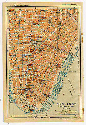
$14.95 Shipping Location: Netherlands ABOUT US VISIT OUR STORE SALES SPECIALS Antique Map-NEW YORK-CITY HALL PARK-USA-Karl Baedeker-Wagner& Debes-1904 Description: This plate originates ... morefrom: The United States with excursions to Mexico. Cuba, Porto Rico, and Alaska. Hnadbook for travellers by Karl Baedeker. 4 th ed. published in Leipzig, New York and London, 1909. Maps by Wagner& Debes, Leipzig. Artists and Engravers: Karl Baedeker(1801-1859) was a German publisher whose company'Verlag Karl Baedeker' set the standard for authoritative guidebooks for tourists. Subject: Map/ plan: New York. Southern part' New York with City Hall, Battery Park and Brooklyn Bridge. Condition: Excellent. General age related toning. Please study scan carefully. Size(in cm) The overall size is ca. 10.5 x 16 cm. The image size is ca. 10 x 14.5 cm. Size(in inch) The overall size is ca. 4.1 x 6.3 inch. The image size is ca. 3.9 x 5.7 inch. Medium: Colour lithograph. Location: C174-04 ThePrintsCollector Peter Cornelissen. Margo van Latum- van Dongen, Frank van Latum Zeeland- The Netherlands Phone: +31 654 21 23 78 Worldwide free shipping on all orders. We ship within one business day upon receipt of payment. We ship by Registered Mail. Insurance is included. We guarantee our items to be genuine original. Visit our Store: we would like to invite you to review similar items in our Store or to browse through all other items in our Store. We are confident that you will find very special unique antique maps and prints in our Store. It is our privilege to have you as a customer. We accept Paypal payments and payment by bank transfer. Combined auction/ buy it now orders are possible! We will send a Paypal invoice on request! THE PRINTSCOLLECTOR GUARANTEES ITEMS SOLD THROUGH EBAY ARE GENUINE ORIGINAL ANTIQUE PRINTS IN THE CONDITION/TECHNIC AS DESCRIBED. ITEMS CAN BE RETURNED WITHIN 7 DAYS. Powered by
|
|
|
In
|
Charming MANHATTAN Map NEW YORK CITY Baseball Dodgers Giants 1950s Picture Map
VINTAGE PICTURE MAP OF MANHATTAN- NEW YORK CITY This fun pictorial map features amusing sketches of the Brooklyn Dodgers. Metropolitan Opera, New York Giants, Harlem, China Town, the Italian Quarter, museums and more. I think it would be fun to frame several of these maps and display them in a group. A grouping might include your birthplace. Places you have visited on vacation or a honeymoon. These make fun gifts! This is an original. Not reproduction, vintage picture map which was carefully removed from a 1950 book. The print measures approximately 4" by 6.5" and is in very good condition. Please notice the top left corner where the"New York" banner extended to the opposite page. Your item will be packaged in a plastic sleeve. With a thin piece of backing, then in a manila envelope with a very stiff and thick piece of ... morecardboard. We happily combine purchases to save on shipping fees. Please email with questions. We will answer your email promptly! Please visit our ebay store. Plaindealing Vintage Paper. Be sure to add me to your! Check out my! Powered by The free listing tool. List your items fast and easy and manage your active items. RcmdId ViewItemDescV4,RlogId p4%60bo7%60jtb9%3Fvo%7B%3Dd70f%2Bf54%3E-147d2bb01e9-0x116-
|
|
|
Charming MANHATTAN Map NEW YORK CITY Opera BOXING Ice HOCKEY 1950s Picture Map
VINTAGE PICTURE MAP OF MANHATTAN- NIGHT TIME NEW YORK CITY This fun pictorial map features amusing sketches of the Metropolitan Opera. Boxing, ice hockey, night clubs, Carnegie Hall, and more. I think it would be fun to frame several of these maps and display them in a group. A grouping might include your birthplace. Places you have visited on vacation or a honeymoon. These make fun gifts! This is an original. Not reproduction, vintage picture map which was carefully removed from a 1950 book. The print measures approximately 6" by 4" and is in very good condition. Your item will be packaged in a plastic sleeve. With a thin piece of backing, then in a manila envelope with a very stiff and thick piece of cardboard. We happily combine purchases to save on shipping fees. Please email with questions. We will answer your email promptly! ... morePlease visit our ebay store. Plaindealing Vintage Paper. Be sure to add me to your! Check out my! Powered by The free listing tool. List your items fast and easy and manage your active items.
|
|
|
1943 Map Lower Manhattan Island New York Hudson Central Park East River
1943 Map Lower Manhattan Island New York Hudson Central Park East River MAP OF Manhattan FROM 1943 This map is Authentic and is 70+ Years– Old Vintage World War II era Antique This map was Printed in 1943. During the Second World War. This beautiful. 70-year-old color map of Manhattan is indexed and shows Island of Manhattan, bounded by Hudson, East River and Harlem River. Central Park, Weehawken, Hoboken, Jersey City. Bridges: Lincoln tunnel, Holland Tunnel, Brooklyn Bridge, Manhattan Bridge Williamsburg Bridge, Queens Midtown Tunnel, Queensboro Bridge. Greenwich Village, Bowery, East Side, Financial District, Grand Central Terminal, Welfare Island. Broadway, Henry Hudson Parkway, Fort Green Park. Actual Map printed area 9.25 inches by 12.5 inches(23.3 cm by 31.5 cm. while the paper on which this map is printed measures 11 by 14(about 27 ... moreby 35 cm. Map is in Fine condition. Map has some age toning. This map is wonderful for genealogy purposes. Map is printed on a single sheet of thick paper and was carefully removed from an antique atlas. There is printing on the reverse side of this map. There are no folds. Creases, marks or stains. This map is suitable for framing. This map is NOT a modern copy or reproduction. This printed antique is certain to appreciate in value over time making it an excellent investment. Please ask all questions before making your purchase.
|
|
|
New York City & Environs Brooklyn Manhattan original uncommon 1894 antique map
New York von Umgebung(New York City& Environs) Issued 1894. Leipzig Uncommon original antique color lithographed German map. Printed on quality paper which retains its inherent structural flexibility and soundness. In VG or better condition. Mostly clean and attractive, minor light surface age wear, overall the image is clean and very attractive[note: we grade very conservatively and always seek to disclose any noteworthy flaws] The printed area remains visually pleasing. A nice impression of an interesting and rather uncommon antique map. Any minor defects along the sheet edges and in the margins may be seen in the photos. Original fold-line as issued. Sheet measures c. 9 7/8" W x 12 7/8" H. Printed area measures c. 8 1/8" W x 10 1/2" H. 57884] Guaranteed Authentic! We do not sell modern reprints. Condition: We only ... morehandle. Sell& ship original vintage and antique items. Old printed sheets of paper. Items which are really old, like we say. We strive to describe our items accurately. We understand you cannot see it in person. We are trying to present it accurately. We try to convey the condition correctly with careful digital photography. Accurate flat-bed scans of the item which are zoomable, printed sheet& image dimensions and knowledgeable descriptive words. It is important to understand that many. If not most old items survive merely by chance, and all are somewhat unique if you inspect them closely. Few of the same type match exactly if compared side-by-side. Each has it's own characteristics and patina. Individual pieces have typically seen numerous owners and been handled many times over the course of their existence. On old sheets of paper. Short edge splits( which are often carefully repaired with discrete small pieces of archival tape) Foxing, discoloration, etc. are all things to expect. It's often unrealistic to expect all old sheets of paper to survive looking like new or without flaws. The key to any printed sheet is the overall visual appeal of the piece. Oten
|
|
|
Manhattan (Kansas) Area Offers Scenic,Historic Play-A-Day Tour Map
Manhattan(Kansas) Area Offers Scenic.Historic Play-A-Day Tour Map Manhattan(Kansas) Area Offers Scenic.Historic Play-A-Day Tour Map. Map shows points of interest which are described in the Index along the right side. Complete and in good used condition Buyer to pay $2.15 S&H 643.RcmdId ViewItemDescV4,RlogId p4%60bo7%60jtb9%3Feog4d71f%2B%3E643-147d327286a-0x11a-
|
|
|
1935 New York, Upper Manhattan Rand McNally map from Collier’s Atlas
1935 vintage New York. Upper Manhattan Rand McNally map, approximately 9" by 12" or 23cm x 30cm, in very good condition with no folds or creases. The page was removed from a 1935 Collier’s Atlas. It will be mailed flat in a cardboard mailer. It is perfect for being a piece of framed art to be hung for display. We will combine purchases to save on shipping fees. Powered by The free listing tool. List your items fast and easy and manage your active items.
|
|
|
1935 New York, Lower Manhattan Rand McNally map from Collier’s Atlas
1935 vintage New York. Lower Manhattan Rand McNally map, approximately 9" by 12" or 23cm x 30cm, in very good condition with no folds or creases. The page was removed from a 1935 Collier’s Atlas. It will be mailed flat in a cardboard mailer. It is perfect for being a piece of framed art to be hung for display. We will combine purchases to save on shipping fees. Powered by The free listing tool. List your items fast and easy and manage your active items.
|
|
|
Vintage 1942 Upper Manhattan Bronx Atlas Map NY New York City World War WWII Era
Vintage 1942 Upper Manhattan& Bronx Atlas City Map NYC New York City A Wonderful Gift! Great OLD Map from the"COLLIER'S WORLD ATLAS& GAZETTEER" Copyright 1942 72 Years Old! The Actual Page! NOT a Copy! Upper Manhattan& The Bronx. New York City, NY(Contact Us For More Photos) This Map Measures About 10 3/4 x 14 1/8" Map Shows Points of Interest. Yankee Stadium. The East, The Harlem& The Hudson Rivers, Hell Gate, The Botanical& Zoological Gardens, Central Park, The Bronx, Polo Grounds, Fordham University, Palisade AmusementPark, Etc. Very Educational. See what the City used to look like! On The back There Are Photos Of The New York Medical Center& Rockefeller Center It Will Look GREAT When Matted& Framed! World War II ERA Black& White A Really Nice Gift! A GREAT House Warming Gift! The Perfect ... moreGift! This Map Can Line Up& Be Framed With The"Lower Manhattan" Map From The Same Year! Ask Us If We Have The Map of The Same Year If It Is Not Listed Teachers& Politicians LOVE Them! Super For a Local Business or Office! Shipping by 1st Class or Priority Mail We Will Combine Shipping on Up To 4 Maps for the same shipping fee Email Us With Any Questions or For an International Shipping Quote Check out my other items! Be sure to add me to your favorites list! Thanks For Looking! International Buyers– Please Note: Import duties. Taxes, and charges are not included in the item price or shipping cost. These charges are the buyer's responsibility. Please check with your country's customs office to determine what these additional costs will be prior to bidding or buying. Certain images and/or photos used in this template are the copyrighted property of JupiterImages and are being used with permission under license.
|
|
|
MANHATTAN LONG ISLAND NEW YORK ANTIQUE HAND COLORED GRAPHIC ILLUSTRATED MAP
ORIGINAL HISTORICAL EPHEMERA EARLY ENGLISH GEOGRAPHY NEW YORK CITY MANHATTAN& LONG ISLAND ANTIQUE HAND COLORED GRAPHIC ENGRAVING ILLUSTRATED MAP PRINT 1870s MEASURES 7.25 x 9 INCHES SUITABLE FOR FRAMING FAIR CONDITION, W/ SEVERAL EDGE TEARS& TONING AGE WEAR PLEASE SEE IMAGES& IGNORE OUR'K-TOWN' WATERMARK
|
|
|
Central Park map Manhattan parks color New York City
Normal 0 false false false EN-US X-NONE X-NONE MicrosoftInternetExplorer4 Here is a brochure titled The Central Park issued by the Greensward Foundation and the Friends of Central Park. 1994, in color, on glossy paper, 24 inches by 16 inches with several maps. One map is CENTRAL PARK from north to south and extends from Columbus Ave. to Park Ave. Another map is titled MANHATTAN ISLAND AND ITS PARKS showing Manhattan landfill. Land set aside for parks but used for other purposes, and current parks. There also is a vertical profile of central park. In addition. There is a smaller map of Manhattan in the 1850s. Brochure is in perfect condition. PAYMENT OPTIONS: PayPal. Insurance optional but recommended: Flat rate of $1.95 for first $50.00 of insurance. Insurance required if final value over $50.00.
|
|
|
1910 Red Book Info Guide to New York City with Manhattan/Bronx Street Map
This handy street map and information guide to Manhattan and the Bronx dates from approx. 1910 and features not only street maps but information on subway routes. Schools, churches etc. at the turn of the century. Also includes a fold out street map for Manhattan and the Bronx. Measures 3" x 6" and is in fair condition.
|
|
|
7201 Street Guide to New York City Manhattan & Bronx 1942 Geographica Map Co.
7201 Street Guide to New York City Manhattan& Bronx 1942 Geographica Map Co. Excellent condition. 96 pg. staple bound booklet. Printer signature: None. All items original to period- No reproductions sold in my store. For more ephemera relating to New York City. NY, American Studies, genealogy, family history, or ephemera in general, go to my Ebay store: http:stores.ebay.com/Kit-Barry-Ephemera-Vintage-Paper Also. There is a weekly auction. All items original to period- No reproductions sold in my store. Item pictured = Item sold. No Stock Images used. The item pictured is the one you purchase. Scans may exaggerate flaws. Wrinkles. Age toning, spots can show more or darker than in real life. Your comments on any aspect of my store and auction are welcome. With response from you. I can improve the presentation. Comments regarding any aspects ... moreare welcome, but a specific interest to me is your reaction to how I approach the descriptions. Is there too much detail or information? Is the description useful? Do you read them or skip them? You are welcome to email questions or information. Beside selling ephemera. I curate a free-use research library for anyone wanting to use ephemera as a research tool- The Ephemera Archive for American Studies. I am always looking for information about business ownership and activities, and product history. Immigrant information and family stories are helpful. I am also looking to acquire business papers and advertising of any type, any quantity, and any time period.
|
|
|
Original 1804 Map New York Harbor Long Is Manhattan Brooklyn Staten Is Hudson
An original 1804 map/ chart of New York Harbor titled"Plan de la Baie de New York" by Blondeau. The map hows the southern part of Manhattan as it was in 1804 with parts of Brooklyn. Long Island, Staten Island, Newark and New Jersey. Locations featured are Kings-Bridge. Utrecht, Gravesend and Powles Hook. The black and white map measures 4" x 6" and is in very good condition.
|
|
|
1901 GREATER NEW YORK Map MANHATTAN Brooklyn Jersey City 1900s Antique Map
VINTAGE MAP OF GREATER NEW YORK Including: Manhattan. Brooklyn, Jersey City, Long Island City, Newark and more. This is an original. Not reproduction, vintage map which was carefully removed from an atlas. This map measures approximately 13" by 10.5" and is in very good condition. Your item will be packaged in a plastic sleeve. Within a cardboard mailing tube. We happily combine purchases to save on shipping fees. Please email with questions. We will answer your email promptly! Please visit our ebay store. Plaindealing Vintage Paper. Be sure to add me to your! Check out my! Powered by The free listing tool. List your items fast and easy and manage your active items.
|
|
|
Lot of 2 Vintage NYC Road Maps Harbor Terminal Manhattan Street Map & 2 AAA Maps
Lot of 2 Vintage NYC Road Maps- Harbor Terminals Port Authority Map. Geographia's Manhattan Street Map& 2 NYC AAA Maps. 4 Maps total. Please email me with any questions prior to bidding and pay within 3 days of auction close. Thanks! Please check my other auctions for vintage maps!
|
|
|
1963 bollmann pictorial map of New York Midtown Manhattan (Very Good Condition)
Pictorial map of Midtown Manhattan with the buildings rendered as a bird's eye view in isometric perspective. The map was produced by Hermann Bollmann. This map comes with a multilingual guidebook to the city. Map and Booklet are in very good condition with no marks or tares.
|
|
|
1846 ORIGINAl Map of Manhattan, New York
Original uncolored engraving as issued. Blank on verso. Dated in the plate. Engraved by R.H. Pease. Albany. Entered into U.S. Congress by John Hutchings. Image area is 18.25" w by 14.25" h. Interesting and detailed map extending from Canal Street to Warren Street. Shows the"Collection Pond" located between Franklin Street and Duane Street. This is an unusual item giving credit to John Fitch for the invention of the Steam Boat in 1793. Well before Robert Fulton. The map is based upon a drawing in 1793 showing the depth of the pond to be 60 feet. There are two vignettes of Steam Boats and testimonials by various personages witnessing the event. This is a large multi-folded leaf which generally did not survive. Especially in this condition. Beautifully executed. Will frame nicely. Overall good condition with moderate ageing. ... moreMulti-folds are intact. There is a 1.5 inch tear in the upper right margin. As well as, a short binding tear which have been mended with acid free material. See photos. Low starting bid with no reserve. Postage charge is for domestic insured priority mail.
|
|
|
1941 Vintage Map Manhattan Island New York Hudson East River Financial District
AN ORIGINAL 1941 Map of Lower Manhattan Island. NY Provenance Authorized Map print removed from an Atlas Published Date 1941 Map Maker Rand McNally Size/ Format Page Size: 10” x 15” Condition Very good. Remarks 1941 Vintage Antique Map Manhattan Island New York Hudson East River Financial District Borough Greenwich Village Central Park 2.
|
|
|
Vintage 1952 Los Angeles City Map Rand McNally & Union 76, Dougs Manhattan Beach
Vintage 1952 Los Angeles City Map sponsored by Union Oil Company and printed by Rand McNally. There is an ink stamp on the back cover where I believe it was distributed at Doug's Union at 3701 Highland Ave. Manhattan Beach. The brochure folds open like a book and contains a 7 page index/key and 15 pages of maps. The interior condition is very good with the exception of some rust and discoloration around the staples. The outer cover is lightly soiled and it has a light musty odor as a lot of old ephemera does. Please inspect the pictures. Shipped FREE via USPS First Class with appropriate care. Thank YOU! Payment I have had to take precautions because of people not paying. You will have 4 days to pay. Then an unpaid item case will be opened. From this point you will have another 4 days to pay. That's EIGHT total days, however if you ... moredon't pay the case will close and show on your Ebay record. At this time the item will be offered to the next highest bidder or re-listed. A case HAS to be opened to recoup selling fees. Shipping I only ship within the US or to eligible Countries through the Ebay Global shipping program(however I don't use this for all items) If it doesn't say I ship to your Country in shipping details. Then I won't, no exceptions, sorry. The shipping service will depend on the buyers location and the package weight. I predominantly use Priority Mail unless an item qualifies for First Class, however I will use Parcel Select in some instances particularly if you live out West(I am based outside of Buffalo, NY) I am not a business and I reuse boxes and packaging so my packages aren't always the prettiest, but I do spend a lot of time and effort in ensuring items are packed with care, handled fast and shipped using an expedited service when possible. Bids/Offers I will NOT end items early via accepting a buy it now price or even respond to people offering amounts in exchange for me ending the item early. If I am selling an item via auction it will not end prematurely unless I m
|
|
|
1908 ORIGINAL VERY LARGE ANTIQUE CITY MAP OF NEW YORK MANHATTAN HARLEM / BRONX
1908 ORIGINAL ANTIQUE CITY MAP OF NEW YORK MANHATTAN HARLEM/ BRONX This original antique map gives you an opportunity to examine in exquisite detail a piece of history. If you are interested in the past of this country and its people or have a desire to study where your family may have come from. Then this map gives you a rare look as the area was about 106 years ago. Once matted and framed, this map would make a perfect gift for a family member or friend they'll cherish forever. Origin of the map: Walker's International Atlas" Published by Henry B. Walker, Philadelphia, USA. Date of issue: 1908 Size: The sheet measures 26 3/4" x 18 1/2" 68 x 47 cm) S/H: The map will be shipped by Air Mail. The shipping charge is: USA- 8.00 USD. World- 9.00 USD, Canada- 9.00 USD. The price includes the insurance and a strong, cardboard ... moretube with plastic plugs. Attention! There is no additional shipping charge for multiple purchases! Pay me securely with any major credit card through PayPal! Payment methods: US/Canada Buyers: Paypal International Buyers: Paypal. Click Here. Double your traffic. Get Vendio Gallery- Now FREE! USED USED. AN ORIGINAL ANTIQUE MAP. USED. di,RcmdId ViewItemDescV4,RlogId p4%60bo7%60jtb9%3Fuk%601d72f%2Bishhov%3C%3Edi-1480c37fdca-0xff-
|
|
|
Vintage 2004 Manhattan Bus Map New York City Transit Routes Subway Connections
Up for bid is a vintage February 2004 Manhattan Bus map for NYC New York City Transit. Interesting map showing subway connections. A wonderful step back in time and to add to your collection! RcmdId ViewItemDescV4,RlogId p4%60bo7%60jtb9%3Fuk%601d72f%2Bfg2%3E-1480fceff6c-0xec-
|
|
|
Vintage C.W. Bromley Manhattan Double Paged Atlas Map of W. 32nd- W. 37th Sts.
Vintage C.W. Bromley Manhattan Double Paged Atlas Map of W. 32nd- W. 37th Sts. This is a double paged linen backed map of Manhattan from West 32nd Street to West 37th Street in 1920. The map is hand colored and vintage. It is the 21st plate in a 1920 Volume 2 G.W. Bromley Atlas of Manhattan from 14th Street to 59th Street. The map measures approximately 32 inches long by 22.5 inches wide. The scale is 80 feet to one inch. The linen-backed map is suitable for framing. Please see the pictures and make purchasing decisions on the information they provide. We will be listing vintage atlases and maps of Manhattan in the near future. TAKE A LOOK AT OUR OTHER AUCTIONS! Shipping cost is not negotiable. All items are packaged with great care. Please note that all items are shipped within 3 business days of cleared payment. NOT including day of payment. ... moreAll items are shipped Monday- Friday only. Destinations of Alaska. Hawaii and Puerto Rico may incur extra shipping charges and will be quoted accordingly. Everything stated in the description of this ad is strictly opinion based on information gathered from researching similarly sold items on Ebay and other avenues. All items sold"as is. If you have any questions please send an email and we will try to get you the answer. Please be patient for a response as we do have full time jobs and this is a hobby of ours! ~~Thank you for looking and happy bidding~~.
|
|
|
MAP NEW YORK CITY WORLDS FAIR OIL GAS STATION CAR AUTOMOBILE VISITOR MANHATTAN
Up for bid is a used NYC map. Indiana residents add 7% sales tax. No returns accepted. The shipping price quoted above includes shipping to the Continental United States. Alaska and Hawaii. All other US postal addresses require extra postage. Please wait for the invoice which will include the proper postage. International bidders please note: Import duties. Taxes and charges are not included in the item price or shipping charges. These charges are the buyer's responsibility. Please check with your country's customs office to determine what these additional costs will be prior to bidding/buying. All International shipping will be by priority international mail and have insurance added(international priority charges begin at $48.00 minimum) A handling fee of $2 US will be added to shipping to cover the cost of filling out the paperwork. ... morePowered by The free listing tool. List your items fast and easy and manage your active items. a;06d2.RcmdId ViewItemDescV4,RlogId p4%60bo7%60jtb9%3Fuk.rp73%28%3Ea%3B06d2-1481f75d68f-0xfa-
|
|
|
Vintage 2001 Manhattan Bridge New York City Transit Subway Brochure Map NY
Up for bid is a vintage July 2001 brochure for when the New York City Transit had Manhattan Bridge Service changes. It shut down the bridge. Brochure with map inside to see how this was run for 3 years. A wonderful step back in time. 12a 336.RcmdId ViewItemDescV4,RlogId p4%60bo7%60jtb9%3Fvo%7B%3Dd70f%2B%3E336-1481f7ec7e3-0x119-
|
|
|
WELCOME TO MANHATTAN KANSAS MAP CHAMBER OF COMMERCE 1960'S
WELCOME TO MANHATTAN KANSAS MAP WHERE PEOPLE PLAY AND PROSPER CHAMBER OF COMMERCE 1960'S
|
|
|
Manhattan NYC Subway and address cross street finder formula wallet map
8" by 2.5" inches printed on a very thin cardboard Dated July 2007 You'll need your glasses on to be able to read this. if you wear glasses Neat formulas for finding the cross street for an address on an Avenue From New York Magazine i think
|
|
|
Vintage C.W. Bromley Manhattan Double Paged Atlas Map of E. 42nd St.- E. 47th St
This is a double paged linen backed map of Manhattan from East 42nd St. to East 47th St in Manhattan. The map is hand colored and vintage. It is the 32nd plate in a 1920 Volume 2 G.W. Bromley Atlas of Manhattan from 14th Street to 59th Street. The map measures approximately 32 inches long by 22.5 inches wide. The scale is 80 feet to one inch. The linen-backed map is suitable for framing. This map contains many historic Manhattan landmarks including the Hotel Biltmore. Ritz Carlton, Grand Central Station, and Hotel Commodore and the Chrysler Building. Please see the pictures and make purchasing decisions on the information they provide. We will be listing vintage atlases and maps of Manhattan in the near future. TAKE A LOOK AT OUR OTHER AUCTIONS! Shipping cost is not negotiable. All items are packaged with great care. Please note that all ... moreitems are shipped within 3 business days of cleared payment. NOT including day of payment. All items are shipped Monday- Friday only. Destinations of Alaska. Hawaii and Puerto Rico may incur extra shipping charges and will be quoted accordingly. Everything stated in the description of this ad is strictly opinion based on information gathered from researching similarly sold items on Ebay and other avenues. All items sold"as is. If you have any questions please send an email and we will try to get you the answer. Please be patient for a response as we do have full time jobs and this is a hobby of ours! ~~Thank you for looking and happy bidding~~. 006.RcmdId ViewItemDescV4,RlogId p4%60bo7%60jtb9%3Fuk%600d72f%2B%3E006-14833726805-0x110-
|
|
|
Townsend MacCoun 1909 Map:'Island of Manhattan 1609' Discovery 17" x 52"
1609 The Island of Manhattan( Mannahtin) At The Time of Its Discovery. Showing its Elevations, Water-courses, Marshes and Shore Line etc etc. Based upon early colonial surveys of Ratzer, Montresor, Knypthause, Bradford, Duyckinck etc. and the Survey of 1867 by Gen'l E. L. Viele' with identified Indian Nomenclature( in red) present streets& shore line for identification, Copyright 1909 Townsend MacCoun, New York. Rare original item in sound condition published for the Hudson Fulton Celebration in 1909. Please contact me with questions or additional scans. Multiple items can be sent for little or no additional postage. $7.50 Priority Shipping in the US; FREE Economy shipping with"Buy it Now" Elsewhere: whatever it costs. Please note that I always send items the same or next business day& Never charge more than the ... moreactual cost for shipping and refund overpayment of postage if it amounts to less than invoiced. The exception would be in the case of a potential buyer who is bidding on another of my items with the bidder's approval. So BEFORE entering fewer than five stars when leaving feedback for fair shipping charge or lack of promptitude in sending an item. Please contact me so that all can be made right. I shouldn't be held responsible for any shortcoming on the part of the post office nor their rate schedule.
|
|
|
1904 BELCHER HYDE ATLAS MAP OF DOWNTOWN BROOKLYN - BROOKLYN & MANHATTAN BRIDGE
Up for sale is a rare and very large original Atlas/Map of Parts of Wards 1. 2 and 4 of Brooklyn, New York 1904. It measures 27 1/2 x 37. It is on linen and in Ex+/Nr. Mint. Map covers Downtown Brooklyn from Jay Street to the West and Furman Street to the eest and from Plymouth and John to the north to Cranburry and High Streets to the south. Most important this map depicts the towers and road leading to the Brooklyn Bridge and the Proposed towers of the Manhattan Bridge will would open five years later in 1909. The roman numerals indicate how many stories each building is and each color represents the type of structure. Yellow is wood. Grey is concrete, blue is iron and pink`is brick. The Xs through the buildings indicate it is a barn or stable. The brown streets indicate cobblestone while green indicates macadamized pavement and white means ... moreit is unpaved. I am selling my collection of rare Brooklyn maps. If there is an area or street address of Brooklyn. Manhattan, Queens, Staten Island, Bronx, Newark, Cleveland, Boston Rochester that you might be interested in, contact me and I will place it on BUY IT NOW. I have insurance maps from 1880 to mid-1950s. Looks great framed! Check out my!
|
|
|
Vintage New York City Borough of the Bronx Map 1903 & Part of Manhattan & Queens
Vintage New York City Map Unique Antique Map of the Borough of the Bronx Wonderful Color Map from 1903- Excellent Bright Color and Condition Great Piece to Frame and Hang on Wall Vintage Map Displays areas of Bronx and parts of Queens and Manhattan Map measures Approx 13" 33 cm) by 10" 25.5 cm) Map Comes From Encyclopedia Map has fold in back- See Pictures for Condition Please Check out my Other Auctions for Many More Maps! Additional Information Items ship within one business day Happiness with your purchase is our only Goal Returns Accepted within 14 Days if you are not happy with your purchase Item must be returned in Original Condition At Erickson and Son we strive to put in the effort to make sure you have an exceptional experience when purchasing from Erickson and Son. If you have any issues with the product you have received. ... morePlease contact us to ensure correct measures are taken to provide you with a pleasant buying experience.
|
|
|
1920's Rand McNally Street Map of Manhattan: Subways; Els; Ferries: Tubes etc.
1920's Street Map on Manhattan from Rand McNally's Metropolitan Map of New York City: Scale 2600' to 1" measures 5" x 7" folded; 9 3/4" x 33 3/4 unfolded. Cover measure 5" x 7 1/2" Please contact me with questions or additional scans. Multiple items can be sent for little or no additional postage. $2.32 Shipping in the US; FREE Economy shipping with"Buy it Now" Elsewhere: whatever it costs. Please note that I always send items the same or next business day& Never charge more than the actual cost for shipping and refund overpayment of postage if it amounts to less than invoiced. The exception would be in the case of a potential buyer who is bidding on another of my items with the bidder's approval. So BEFORE entering fewer than five stars when leaving feedback for fair shipping charge ... moreor lack of promptitude in sending an item. Please contact me so that all can be made right. I shouldn't be held responsible for any shortcoming on the part of the post office nor their rate schedule.
|
|
|
1939 TRAVEL FOLDER MAP OF MANHATTAN SHIP TOUR WITH FAIR GROUNDS SHIP MARILDA
1939 TOUR FOLDER FOR MANHATTAN YACHT CRUISES SHOWS MAP TOUR AROUND THE ISLAND LUXURY YACHT MARILDA SHOWS WORLD'S FAIR SITE ON MAP ONE PAGE HAS DRAWING OF FAIR LOGO SUPERIMPOSED OVER WRITING GOOD CONDITION
|
|
|
1920 RARE MANHATTAN Map Beautiful Rare Size Map of New York City
ANTIQUE MAP OF MANHATTAN NEW YORK- NEW YORK CITY Map also includes part of Brooklyn and Jersey City This is an original. Not reproduction, vintage map which was carefully removed from an atlas. This rare map measures approximately 26" by 19" and is in very good condition. This oversized map is a centerfold. Printed on one large sheet of paper. Your item will be shipped First Class in a cardboard mailing tube. Please email with questions. We will answer your email promptly! Please visit our ebay store. Plaindealing Vintage Paper. Be sure to add me to your! Check out my! Powered by The free listing tool. List your items fast and easy and manage your active items.
|
|
|
Highly detailed, historic 1904 map LOWER MANHATTAN, NY - original, antique!
Great looking. Very highly detailed vintage 1904 Map of NEW YORK CITY(SOUTHERN PART MANHATTAN) published by Wagner& Debes. Leipzig Archivally matted Matted size: 7" x 9" Map size:4 1/4" x 6 1/4" Battery Park. City Hall, Brooklyn Bridge, Financial District, Broadway, Subways, etc. Please feel free to email with any questions. Thank you for your interest!
|
|
|
New York City Subway Map Mug Coffee Cup Large Oversized 18 oz Manhattan MTA
New York City Subway Map Mug Coffee Cup Large Oversized 18 oz Manhattan MTA Holds 18 oz. Oversized. 4.5" h X 3.75" diameter at top Excellent pre-owned condition. Clean with no chips or cracks. Some minor marks on bottom from setting down. Brand: MTA Officially Licensed. Likely dishwasher and microwave safe.
|
|
|
1930 ORIGINAL VINTAGE MAP OF NEW YORK CITY / MANHATTAN BROOKLYN NEW JERSEY
1930 ORIGINAL VINTAGE MAP OF NEW YORK CITY/ MANHATTAN BROOKLYN NEW JERSEY This original antique map gives you an opportunity to examine in exquisite detail a piece of history. Once matted and framed. This map would make a perfect gift for a family member or friend they'll cherish forever. Origin of the map: Richter-Muellner Atlas" Published in Vienna, Austria by Hoelder-Pichler-Tempsky A.G. Date of issue: 1930 Size: The sheet measures 27 x 23 cm(10 3/4" x 9" S/H: The map will be shipped by Air Mail. The shipping charge is: USA- 8.00. World/Canada- 9.00. The price includes the insurance and a strong, cardboard tube with plastic plugs. Attention! There is no additional shipping charge for multiple purchases! Pay me securely with any major credit card through PayPal! Payment methods: US/Canada Buyers: Paypal. International ... moreBuyers: Paypal. Click Here. Double your traffic. Get Vendio Gallery- Now FREE! USED. AN ORIGINAL ANTIQUE MAP.
|
|
|
1908 CITY MAP MANHATTAN BRONX NEW YORK CITY DATED
Not a Reproduction 1908 DATED ANTIQUE Vintage Atlas CITY MAP MANHATTAN BRONX NEW YORK CITY From Colliers Atlas Offered here is a old great detailed map of the area The map measures approx. 10 x 12 inches. Larger than my scanner The map is in Good condition. Clean, no markings and would frame nicely. The map is fully guaranteed to be in original and unaltered condition. Check out my STORE for a great selection of 1.00 Maps. S&H 6.00 to the US in cardboard tube Only 1.00 extra S&H cost for each extra map
|
|
|
1871 RARE MAP CENTRAL PARK MANHATTAN SQUARE CROTON RESERVOIR NYC NEW YORK CITY
Greetings! For your consideration: An original publishers map of Central Park/Croton Reservoir. Manhattan, New York City for the First Annual Report of the Board of Commissioners of the Department of Public Parks for the Year Ending May 1, 1871. Published in New York by William C. Bryant& Co and Printed by Brattle Press Inc. This is a nice. Scarce lithograph map of Central Park in Manhattan in 1871. Exposed map measures 34 1/4" x 10 3/4" Including frame it measures 35 3/4" x 12" NO FOLD MARKS! This is an original black and white lithograph printed by The Brattle Press. These maps were made for a book so one typically finds them folded from when it was published and bound into a book. This particular one looks to be an early original or master map. Wonderful detail! Great condition; some very light rippling an occasional ... morespot of foxing but nothing really noticeable. Comes framed and protected behind glass! Overall a nice example of this scarce 1871 map of Central Park. NYC! Please enjoy the photos for further item details and if you have any questions feel free to ask. This item ships Worldwide and requires PayPal payment. Fast payment insures prompt shipping. Thank you and please enjoy our other listings! ag6 2.RcmdId ViewItemDescV4,RlogId p4%60bo7%60jtb9%3Fuk.rp73%28c%3Eag6%3E2-14852b075d6-0x10f-
|
|
|
1935 MANHATTAN Antique Map NEW YORK CITY 1930s Vintage Atlas Map
VINTAGE NEW YORK CITY. MANHATTAN, MAP This is an original. Not reproduction, vintage map of Manhattan, New York City, which was carefully removed from an atlas. Map measures approximately 9.5 x 12 and is in very good condition. Your item will be packaged in a plastic sleeve. Within a cardboard mailing tube. We happily combine purchases to save on shipping fees. Please email with questions. We will answer your email promptly! Please visit our ebay store. Plaindealing Vintage Paper. Be sure to add me to your! Check out my! Powered by The free listing tool. List your items fast and easy and manage your active items.
|
|
|
Vintage1990s New York City Subway Transit Map Manhattan Guide NYC Bus MTA
Up for bid is a vintage 1990's Manhattan Transit New York City Subway Transit Authority Map Guide for the subway and buses in Manhattan. A wonderful step back in time! 12
|
|
|
ANTIQUE PROVIDENCE MANHATTAN TOWNSHIP NEAPOLIS LUCAS COUNTY OHIO HANDCOLOR MAP N
Click Here. Double your traffic. Get Vendio Gallery- Now FREE! Vintage antique 1875 handcolored map. The superb handcoloring is period to the map. This is before color printing. The map is 2 sided and either side would frame and display quite nicely. One side is Map of Providence Township, I see Neapolis, Providence, and much more, at upper right is Providence as well. The map is quite detailed with the named home and land owners, named railroads, business and industry and much more. Many fascianting areas on the map. Reverse is a gorgeous lithograph print, top view is Res of Gershom Crabb, bottom is Res of Geo. Engel, Manhattan Twp. The map is from the very rare 1875 Andreas and Baskin Atlas of Lucas and Wood County Ohio. The photo wont show the true beauty of the map. The map is in nice shape and would frame and display quite beautifully. ... moreThe size of the map is 14.5" by 17.5" Winning bidder pays $4.00 shipping domestic, more foreign. Payment I accept the following forms of payment: PayPal Click to View Image Album Click to View Image Album Shipping& Handling US Shipping. $4.00 USPS First-Class Mail® International Shipping. $11.50 USPS First-Class Mail International FREE scheduling. Supersized images and templates. Get Vendio Sales Manager. FREE scheduling. Supersized images and templates. Get Vendio Sales Manager.
|
|
|
RARE VINTAGE Geographia NEW YORK CITY NYC Street Map Manhattan FOUR MAPS IN ONE
This is a very old map of New York City. It has been used and is not in very good shape. There are holes in the corners and was taped up at one point which really just made things worse. It has maps of: Manhattan. Midtown. Downtown. Financial Section. a transportation map for Queens. Brooklyn, and Manhattan. Central Park. I'm not sure what I have here so I am starting the auction low and letting the market tell. Please email any questions. Please see my store here on eBay for more items. RcmdId ViewItemDescV4,RlogId p4%60bo7%60jtb9%3Fuk%601d72f%2Bfg2%3E-14883e2b8d8-0x10b-
|
|
|
1908 MAP NEW YORK CITY MANHATTAN BROOKLYN BRONX STEET STREETCAR RAILROAD HARBOR
1903 CHICAGO IL MAP HISTORY RAILROAD STEETCAR CGW PRINT ORIGINAL 1908 NEW YORK CITY STREET MAP SHOWING BUROUGHTS OF MANHATTAN, BROOKLYN. KINGS, BRONX THE MAP INCLUDES STREETS. RAILROADS, TROLLEY LINES, SUBWAYS, FERRY LINES, PARKS AND PROMINENT LANDMARKS ITEM DESCRIPTION: PLEASE NOTE: THESE MAPS COME FROM AN OLD ATLAS. You are bidding on 3 PAGES OF MAPS. THESE ARE ORIGINAL 9" X 14" ANTIQUE 103 year old MAPS SHOWING THE RAILROADS. STREETS, STREET CAR LINES, SUBWAYS, DOCKS, FERRY LINES AND RAIL FACILITIES OF NEW YORK CITY. THERE IS AN INDEX FOR MOST STREETS. The copywrite date is shown on the map. see scans) BUY IT NOW BONUS: IF YOU BUY THE MAP AT THE BUY IT NOW PRICE. I WILL INCLUDE A PHOTO OF EITHER A STREETCAR OR RAILROAD LOCOMOTIVE THAT ONCE SERVED IN NEW YORK CITY. PLEASE LET ME KNOW WHAT YOU WOULD PREFER A PRINT OF. MAP DETAILS: ... moreTHIS IS A RARE MAP OF SIGNIFICANT HISTORIC VALUE. THE MAP SHOWS THE DEVELOPMENT OF THE TRANSPORTATION SYSTEM OF THIS CITY AND CAN BE A VALUABLE TOOL IN TRACING REGIONAL TRANSPORTATION DEVELOPMENT AND HISTORY. INITIALS OF ALL RAILROADS ARE SHOWN BESIDE EACH LINE. RAILROADS SHOWN INCLUDE THE LONG ISLAND RAILROAD. NEW YORK CENTRAL& HUDSON RIVER RAILROAD, NEW YORK NEW HAVEN& HARTFORD RAILROAD, WEST SHORE RAILRAOD, NEW YORK ONTARIO& WESTERN RAILROAD, CENTRAL RAILROAD OF NEW JESRSEY, PENNSYLVANIA RAILROAD, LEHIGH VALLEY RAILROAD ERIE RAILROAD, DELAWARE LACKAWANNA& WESTERN RAILROAD, AND THE STATIONS OF EACH OF THESE RAILROADS AND MORE. THE SHIP LINES AND FERRY LINES ARE NAMED ALONG WITH THE LOCATIONS OF THEIR RESPECTIVE DOCKS. THERE IS AN EXTENSIVE STREET INDEX ON THE BACK SIDE OF ONE OF THE MAPS. PLEASE SEE THE VARIOUS SCANS FOR SOME OF THE DETAILS) OWN AND DISPLAY THIS HISTORIC OLD CITY STEET. RAILROAD AND STREETCAR MAP THIS MAP& PHOTO will matt and frame very nicely. These items can be made into a wonderful creative memory display. There is a 1/8" margin around the map. The paper has browned slightly with age but is in very good condition for its age. You
|
|
|
1905 MAP OF NEW YORK CITY MANHATTAN BROOKLYN JERSEY CITY NEWARK STATEN ISLAND
1905 MAP OF NEW YORK CITY MANHATTAN BROOKLYN JERSEY CITY NEWARK STATEN ISLAND This original antique map gives you an opportunity to examine in exquisite detail a piece of history. If you are interested in the past of this country and its people or have a desire to study where your family may have come from. Then this map gives you a rare look as the area was about 110 years ago. Once matted and framed, this map would make a perfect gift for a family member or friend they'll cherish forever. Origin of the map: Meyers Hand-Atlas" Published by Bibliographisches Institut in Leipzig, Germany and Vienna, Austria. Date of issue: 1905 Size: The sheet measures 11 3/4" x 9 1/2" 30 x 24 cm) S/H: The map will be shipped by Air Mail as a Letter. The shipping charge is: USA- 4.00 USD/ Canada- 1.80 USD/ World- 6.00 USD. The price includes ... morea strong. Secure envelope. Attention! There is no additional shipping charge for multiple purchases! Pay me securely with any major credit card through PayPal! Payment methods: US/Canada Buyers: Paypal. International Buyers: Paypal. Click Here. Double your traffic. Get Vendio Gallery- Now FREE!
|
|
|
City Map of the Boroughs of Manhattan and the Bronx, N.Y. Copyright 1906
This old map was part of a 1914 atlas. It is in very good condition for being 100 years old. Most of the maps from this Atlas show a much older copyright date. This one is 1906. Page measures 10.25 by 15 inches or 26 by 38.2 cm with actual map a little smaller. The map looks much better than my picture. It shows Streets. Cemeteries, parks and other points of interest in plain and easy to read text. Your map will be shipped flat in a large cardboard enforced envelope enclosed in a plastic sleeve for its protection and safe delivery. You get the original 100 year old map. Not a modern copy.
|
|
|
Old Double sided City Map of New Orleans Louisiana and Manhattan, New York
This old Double sided map was part of a 1914 atlas. It is in very good condition for being 100 years old. Most of the maps from this Atlas show a much older copyright date. This one shows 1908 on both New Orleans and Borough of Manhattan. Page measures 10.25 by 15 inches or 26 by 38.2 cm with actual maps a little smaller. The map looks much better than my picture. It shows Streets. Cemeteries, parks and other points of interest in plain and easy to read text. Your map will be shipped flat in a large cardboard enforced envelope enclosed in a plastic sleeve for its protection and safe delivery. You get the original 100 year old map. Not a modern copy.
|
|
|
MANHATTAN Bus Map - MTA New York City Transit - June 2013 - Ships for Free
Manhattan Bus Map from June 2013 MTA NYC Transit. Comes manufacturer folded. MANHATTAN Bus Map- MTA New York City Transit- June 2013
|
|
|
New York City 1950 How To Get There Street Directory of Manhattan & Bronx w/ Map
This is a terrific Manual of How to get there in N.Y.C.s Manhattan& Bronx area. It is in very nice(gently used) condition. Complete with fold out map attached to the back of the book. It is a 160 page book with every street known to man in this N.Y.C. area. It tells you not only what line to take and at what station to stop, but also how many blocks and in what direction to walk to reach your destination. An absolutely fabulous, must have item.
|
|
|
New York City Map Manhattan East Central Park 5th Avenue Metropolitan Art Museum
Lake Erie Maps& Prints! An Authentic Antique Map: Not a Modern Reproduction! Click here for more! Free Shipping on Purchases of 5 or More Maps and Prints Description: It is an original antique map from G.W. Bromley's Land Book of the Borough of Manhattan City of New York. Published in New York by Bromley& co. 1925. A facsimile copy of the title page will also be included for authenticity. The maps were mainly used by developers and real estate agents who periodically would receive updates of the building changes such as ownership or new structures that were issued as small cutouts that were then glued to update the map thus giving the map a unique character over time. It is handcolored probably with the use of stencils typical of the period. We have currenly listed many additional plates, click here New York City Maps. Please ... moreNote: There are two maps printed back to back on one sheet so if framing one would need to chose a side. It is not mounted. Matted nor framed, being sold as shown in the main pic. Size: The map image measures approximately 10 by 15 inches(25x38cm) on a 11 1/2 by 16 1/4" 29x41cm) page with a margin all around for framing as seen in the pic. Condition: The map is in Good to Very Good overall condition with original hand coloring. There is light tonal ageing. Darkening around the edges, crimping along the binding edge, see the pics for more on condition. Overall, a nice rich patina that would frame up with a desireable antique appearance. The pics are of the actual map. Payment Details: We accept most major credit cards through Paypal and Ebay. Please ask if you have any questions about payment. International and New Bidders are welcomed and encouraged. Payment is expected within 7 days. After which Nonpaying Bidders will be reported to Ebay to recoup our listing fees. Save on Shipping: We only charge one shipping fee based on the largest map or print with multiple items shipped along with it for no extra costs. Purchase 5 or more maps or prints and receive Free First Class shi
|
|
|
1635 Blaeu Map of New England and New York (1st depiction of Manhattan as an Isl
1635 Blaeu Map of New England and New York(1st depiction of Manhattan as an Island) WE SELL ONLY ORIGINAL ANTIQUE MAPS- NOT REPRODUCTIONS Title: Nova Belgica et Anglia Nova. Description: A beautiful example of one of the most important maps in the history of America. Blaeu’s 1635 Nova Belgica et Anglia Nova. Oriented to the west, this map covers the American coast from Virginia, past New York and Long Island to Cape Code, New England, and Quebec. It is cartographically derived from data accumulated by Adriaen Bock and other Dutch fur traders active in the early 17th century. It is known for a number of important firsts, including the first printed representation of Manhattan as an Island. Burden, in his Mapping of North America, notes: This important map was one of the most attractive of the Americas at the time. It is noted for the fact ... morethat its primary source is the first manuscript figurative map of Adriaen Block, 1614. Indeed it is the first full representation of it in print. It is one of the earliest to name Nieu Amsterdam. Block, a Dutch fur trader, explored the area between Cape Cod and Manhattan, examining the bays and rivers along the way. This helped to create an accurate picture of the longitudinal scale of the coastline. His manuscript map is the first document to delineate an insular Manhattan; it also provides the earliest appearance of Manhates and Niev Nederland. It has been noted that the time difference between 1614, the date of the manuscript, and Blaeu's map whose first appearance is in 1635, appears long for such an important advance. It would seem highly feasible that Blaeu, who published many separately issued maps, would have wanted to produce one like this sooner. However, evidence points to the fact that it could not have been made before 1630. The Stokes Collection in New York possesses an example of the map on thicker paper without text on the reverse which could well be a proof issue of some kind. There are features on Blaeu's map that differ from the Block chart. Some of the
|
|
 |