-
Christian Collectibles
-
Christian Sheet Music
-
Vatican Stamps
-
Vatican Coins & Paper Money
-
Antiques
-
Antiquities
-
Architectural & Garden
-
Decorative Arts
-
Ethnographic
-
Furniture
-
Maps, Atlases & Globes
-
United States (Pre-1900)
-
United States (1900-Now)
-
AK, HI
-
AL, FL, GA, MS, NC, SC
-
AR, IA, KS, LA, MO, NE
-
AZ, CA, CO, NM, NV, UT
-
CT, MA, ME, NH, RI, VT
-
DC, DE, MD, NJ, NY, PA
-
ID, OR, WA
-
IL, IN, MI, OH, WI
-
MN, MT, ND, SD, WY
-
OK, TX
-
VA, WV, KY, TN
-
Entire US
-
United States (Date Unknown)
-
Africa
-
Asia
-
Australasia/ Oceania
-
Canada
-
Central America/ Caribbean
-
Europe
-
India
-
Ireland
-
Mexico
-
Middle East
-
North America
-
South America
-
United Kingdom
-
Maps on CD
-
World Maps
-
Globes
-
Mixed Lots
-
Reproductions
-
Price Guides & Publications
-
Other
|
In
Order by: Available to: This site contains affiliate links for which I may be compensated
|
Buy It Now
$12.00 Shipping Location: Melbourne, United States This is a Ontario County New York map from around 1900. It rolls up onto a round dowel at the top. It is very detailed and has many residences in the ... morecounty labeled throughout the county in the rural area.
Buy It Now
$13.71 Shipping Location: MANCHESTER, United Kingdom He based his atlases on the plates used by Edward Weller for his Weekly Dispatch Atlas. This map by George Washington Bacon is from The New Large Scale ... moreAtlas of The British Isles, edited and published by G.W. Bacon, London, 1886.
Buy It Now
$6.95 Shipping Location: Dover, United States Map by Davies. Mid 19th century lithographed English county map with original outline hand color. Soft old original crease across the map which only shows ... moreup in certain light angles (we picture it so as to emphasize).
Buy It Now
$6.95 Shipping Location: Dover, United States Published 1871, New York, by F.W. Beers. Very detailed mid-19th century lithographed map, of great interest for historical genealogical purposes.
Buy It Now
$4.99 Shipping Location: Sackets Harbor, United States
Buy It Now
Free Shipping Location: Freeport, United States Owned jointly by Brian & Marc.
Buy It Now
$6.00 Shipping Location: North Wales, United States 1931 ANTIQUE SURVEY MAP-PARISH CREEK, ANNE ARUNDEL COUNTY, MD-CORPS OF ENGINEERS ORIGINAL ANTIQUE ATLAS MAP PLEASE SEE PHOTOS AS PART OF THE DESCRIPTION ... moreCONDITION: MAP IS IN GOOD CONDITION. FOXING PRESENT. SIZE: APPROXIMATELY 6" X 6.5" SHIPPING: U.S. FIRST CLASS RATE - $6.00 - ANY ITEM WHICH SELLS FOR OVER $100 WILL REQUIRE INSURANCE WE COMBINE SHIPPING FOR MULTIPLE WINS. THANK YOU FOR YOUR INTEREST IN OUR AUCTIONS!.
Buy It Now
Free Shipping Location: Monroeville, United States Date - 1876. Source - Illustrated Atlas of Noble County, Ohio. inventory# j73161.
Buy It Now
$4.13 Shipping Location: Bristol, United States 1980 Miller County, GA Soil Interpretive Map Of Important Farmlands. U.S. Department Of Agriculture Soil Conservation Service. Map has been folded and ... morehas a canceled University stamp and Library notations on the bottom right. It also has a small tear in the margin near the bottom middle. Please see photos for condition. The map measures 24 inches by 19 inches.
Buy It Now
Free Shipping Location: Monroeville, United States Source - Atlas of Muskingum County, Ohio. Date - 1866.
Buy It Now
$5.95 Shipping Condition: New Location: Las Vegas, United States This is a great map of the Counties of the State of Texas & Indian Territory Circa 1875. County map of Texas, and Indian Territory. “Vibrant and bright! ... morePic does not do it justice.looks amazing!”.
Buy It Now
Free Shipping Location: Monroeville, United States Source - An Atlas of Van Wert County, Ohio. Date - 1886.
Buy It Now
$4.15 Shipping Location: Saco, United States
Buy It Now
$6.95 Shipping Location: Dover, United States Late 18th century engraved county map with original hand color.
Buy It Now
$24.10 Shipping Location: Claypool, United States This piece of history belongs in the collection of any map or antique enthusiast, especially if from Fulton County. I have personally owned this item ... morefor over 40 years. All pages intact and in place.
Buy It Now
$6.95 Shipping Location: Dover, United States Late 18th century engraved county map with original hand color.
Buy It Now
$6.80 Shipping Location: Eagle, United States Presented is an authentic, old map taken from a dis-bound plat book, published in 1868. Original hand color.
Buy It Now
Free Shipping Location: Monroeville, United States Date - 1876. Source - Illustrated Atlas of Noble County, Ohio. Size - about - 13.75x17.5", hand-colored.
Buy It Now
Free Shipping Location: Monroeville, United States Date - 1876. Source - Illustrated Atlas of Noble County, Ohio. Size - about - 13.75x17.5", hand-colored.

Buy It Now
Free Shipping Location: Monroeville, United States Original 1882 Mitchell County& Township Map MAINE Railroads Portland Canal Bath Handsome original antique Mitchell county and township map of Maine. ... morePrinted more than 125 years ago. The map labels hundreds of places and features. Including county towns, railroads, canals, lakes, and rivers. There is excellent detail along the coast, from Kittery to Lubec. The map shows the Cumberland and Oxford Canal. From Sebago Lake to Portland, and it labels numerous railroads, including the Bangor& Piscataquis, Sandy River, Maine Central, European and North American, Boston& Maine, Portland& Ogdensburg, Androscoggin& Kennebec, and more. Other details include the Kathadin Iron Works. Twin Lakes Indian Purchase, Mount Desert Island, Camden, Wiscasset, Bowery Beach, Cape Elizabeth, Augusta, Belfast, Auburn, Bath, and various land grants in Somerset, Piscataquis, Penobscot, and Aroostook counties, including Bowdoin College, Hopkins Agency, Sandwich Academy, and Revolutionary Soldiers. This map is dated 1882 in the lower margin. It includes a distrance scale in miles andis titled County and Township Map of the State of Maine. The image area measures a generous 54.8 x 38 cm[21-1/2" x 15" And longitude is measured from Greenwich and Washington. The map is from Mitchell's New General Atlas. Published by William M. Bradley, 1026 Arch Street, Philadelphia, in 1886. Condition: It is in very good condition. Bright and clean, with no marks. Rips, or tears. There is a horizontal center fold, as issued, and it is blank on the back, with no printing on the reverse side. The scans below give a closer look: This is an original. Authentic antique map, not a reproduction or modern reprint. And it is fully guaranteed to be genuine. It would make a wonderful display in your den or office, and we'll include our helpful framing tips for your reference, along with a photocopy of the dated title page from the book in which it was published. We are pleased to offer it with our unconditional. Money-back guarantee. S

Buy It Now
$11.60 Shipping Location: Winston Salem, United States This Auction is for an Unframed MODERN REPRINT of an Antique Map as detailed below. This map is reproduced on specially coated.Matte finish, paper for ... moresharper print quality and colors that are vivid. This is a graphic representation of what the print might look like framed. This listing is for an UNFRAMED print. These maps are created from VERY high resolution uncompressed TIFF files(averaging 200+ megabytes) and are much sharper that the image shown here. Description County Map Of The State Of Maine. Approximate Image Size 16.5 X 20, Original Atlas Title Mitchell's New General Atlas. Containing Maps Of The Various Countries Of The World. Plans Of Cities, Etc. WE HAVE MANY HISTORIC MODERN REPRINT MAPS AND OTHER ITEMS ON MANY DIFFERENT SUBJECTS Please check out store for additonal products FREE SHIPPING BY MAIL(GENERALLY 2 TO 5 DAY DELIVERY) FOR ANY NUMBER OF MAPS SHIPPED IN THE US. SHIPPING IS $15 PLUS $1 FOR EACH ADDITIONAL MAP TO ANYWHERE ELSE IN THE WORLD. WE SHIP ALL MAPS ROLLED IN A MAILING TUBE TO PROTECT THE MAP. IF YOU ARE UNHAPPY WITH YOUR PURCHASE SIMPLY RETURN IT AND WE WILL REFUND YOUR MONEY. Ad copyright 2008 All Rights Reserved Powered by The free listing tool. List your items fast and easy and manage your active items. dhep.RcmdId ViewItemDescV4,RlogId p4%60bo7%60jtb9%3Fuk%601d72f%2Bishm%3Ed%7Fhep-144bddd4018-0x101-
Buy It Now
$5.65 Shipping Location: Saint Louis, United States County, Missouri from 1893. The reverse is blank. Makes a great present for Real Estate. picture processor. The condition is Very Good. The color is Green ... moreNOT Yellow. scan - it is a nice 100+ year old aged toned color.
Buy It Now
$6.95 Shipping Location: Dover, United States Published 1872, Philadelphia, by Sanford, Everts & Co. Alfred Village. Very detailed mid-19th century lithographed map, of great interest for historical ... moregenealogical purposes.
Buy It Now
Free Shipping Location: Schertz, United States This antique original county map was published in 1916 by G. A. Ogle & Co. The lithography printing technique was used to create this plat atlas map, ... morewhich features Madison Township and Harrison Township in Lee County, Iowa. Measuring approximately 14" x 17", this map page is a piece of history that would make a great addition to any map, atlas, or antique collection. Free shipping is available within the USA, and shipping outside the USA is calculated. Don't miss out on the chance to own this unique and rare item.
Buy It Now
Free Shipping Location: Monroeville, United States Source - Atlas of Muskingum County, Ohio. Date - 1866.
Buy It Now
Free Shipping Location: Jetmore, United States Vintage Kansas Maps Hutchison City Map Reno County Map with Townships
Buy It Now
Free Shipping Location: Monroeville, United States Date - 1875. Size - about 13.25x14.25".
Buy It Now
$6.80 Shipping Location: Eagle, United States Presented is an authentic old map taken from a dis-bound plat book published in 1928. Map is blank on the back. Approximate Size is: 16.50 in X 20 in.
Buy It Now
$13.71 Shipping Location: MANCHESTER, United Kingdom He based his atlases on the plates used by Edward Weller for his Weekly Dispatch Atlas. edited and published by George. W. Bacon, London, 1883. This map ... moreby George Washington Bacon is from The New Large Scale Ordnance Map of The British Isles with Plans of Towns.
Buy It Now
$6.95 Shipping Location: Dover, United States Late 18th century engraved county map with original hand color.
Buy It Now
$18.85 Shipping Location: STAFFORD, United Kingdom Original map extracted from 1868 copy of John Heywood's County Atlas of England and Wales. See photos.
Buy It Now
$6.95 Shipping Location: Dover, United States Leicestershire and Rutlandshire. Map by John Dower. Mid 19th century lithographed English county map with original outline hand color. Soft old original ... morecrease across the map which only shows up in certain light angles (we picture it so as to emphasize).
Buy It Now
Free Shipping Location: Monroe, United States ORIGINAL ANTIQUE 1953 COLOR MAP OF THE STATE OFNORTH CAROLINA. MAP HAS SCALE BELOW TITLE. SOURCE/REMOVED FROM- 1953 INTERNATIONAL STANDARD ATLAS OF THE ... moreWORLD. LAST PICTURE IS THE TITLE PAGE FROM WHICH THE MAP WAS REMOVED.
Buy It Now
Free Shipping Location: Kennebunk, United States This Map was removed from a 1918 Atlas and is in good acceptable condition. Only Authentic Originals. Study the photos carefully, this is the actual map ... moreyou. The book & title page are not included but only used as a verification reference.
Buy It Now
Free Shipping Location: Schertz, United States This Map was removed from an 1889 Cram's Atlas and is in very good condition. () Nice original coloring. This map is not dated. This map in not new or ... morein new condition. It was printed in 1889.
Buy It Now
$6.00 Shipping Location: Pomfret Center, United States THIS IS NOT A REPRINT.
Buy It Now
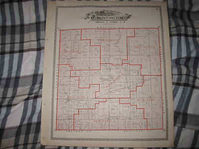
$3.75 Shipping Location: Winter Springs, United States Click Here. Double your traffic. Get Vendio Gallery- Now FREE! Fine antique color lithographed map. Titled Map of Huntington Township. I see Huntington ... moreCentre, and many fascianting areas, the railroads, and more. The map shows the home and land owners, districts, tracts, named railroads and much more. This is an antique map and not a reprint or reproduction. Fine period color lithography, nice outside ornate border, printed on thick paper, with no printing on reverse. The map is from the very rare 1896 American Atlas of Lorain County Ohio. The map is a fascinating and historic period look at this area at this time. The map shows the home and land owners, railroads, and much more. The photo wont show the full beauty of the map. The map is in nice shape, tight and clean. The size of the map is 15.5" by 18.5" Winning bidder pays $3.75 shipping domestic, more foreign. Payment I accept the following forms of payment: PayPal Click to View Image Album Shipping& Handling US Shipping. $3.75 USPS First-Class Mail® International Shipping. $11.50 USPS First-Class Mail International FREE scheduling. Supersized images and templates. Get Vendio Sales Manager. FREE scheduling. Supersized images and templates. Get Vendio Sales Manager.
Buy It Now
$4.00 Shipping Location: United States Antique 1872 handcolored map. The condition of the map is amazing. There is no printing on reverse, and the map is printed on thick fine paper. This is ... morean antique map and not a reprint or reproduction.
Buy It Now
$6.95 Shipping Location: Dover, United States County Map. Issued 1850's, London for the Dispatch by Edward Weller. Mid 19th century lithographed English county map with original outline hand color. ... moreSoft old original crease across the map which only shows up in certain light angles.
Buy It Now
$13.71 Shipping Location: United Kingdom He based his atlases on the plates used by Edward Weller for his Weekly Dispatch Atlas. This map by George Washington Bacon is from The New Large Scale ... moreAtlas of The British Isles, edited and published by G.W. Bacon, London, 1886.
Buy It Now
$4.00 Shipping Location: United States This is an antique handcolored 1875 map and not a reprint or reproduction. The handcoloring on the map is period to the map, this is before color printing. ... moreThis is a fascinating historical portrait of this area, in 1875.
Buy It Now
$6.95 Shipping Location: Dover, United States Issued 1875, New York by F.W. Beers. Very detailed mid-19th century lithographed map with original hand color. Of great interest for historical genealogical ... morepurposes.
Buy It Now
Free Shipping Location: Schertz, United States This Map was removed from an 1889 Cram's Atlas and is in very good condition. () Nice original coloring. This map is not dated. This map in not new or ... morein new condition. It was printed in 1889.
Buy It Now
Free Shipping Location: Schertz, United States This Map was removed from an 1876 Indiana Atlas and is in good acceptable condition. The map is not " new " or in " new " condition, it was printed in ... more1876. The map is not dated. Study the photos carefully, this is the actual map you will receive.
Buy It Now
$24.00 Shipping Location: Easthampton, United States WOODFORD, E. M. Map of Windham County, Connecticut. Philadelphia: E. M. Woodford, 1856.
Buy It Now
Free Shipping Location: Schertz, United States This antique plat atlas map was created by L. H. Everts & Co. in 1887 and features Jefferson County, Kansas. The map showcases the Valley Falls Township ... moreand Osawkie on the reverse side, and all colors are original. It is an authentic antique original that was printed in 1887, making it a valuable addition to any collection. This piece is perfect for anyone looking to add historical value to their home, office, or personal collection. The year of creation is 1887, making it a rare and unique item for collectors and enthusiasts alike.
Buy It Now
Free Shipping Location: Monroeville, United States Source - Atlas of Preble County, Ohio. Date - 1871. Size - about 12x15", hand-colored.
Buy It Now
Free Shipping Location: United States This antique world atlas from 1891 features a detailed county map of Maryland and Delaware, as well as the District of Columbia. It is an original piece, ... moreadding to its value as a collector's item. The map is in excellent condition, with intricate details and vibrant colors that are sure to impress any viewer.
Buy It Now
$4.99 Shipping Location: Fairview, United States The publishing details and date are in the title area of the map. There is also a map on the reverse side. The pics are of the actual map.
Buy It Now
Free Shipping Location: Carefree, United States ORIGINAL ANTIQUE 1934 COLOR OUTLINE MAP OF THE STATE OFNEW JERSEY. ALSO SHOWN ARE PORTIONS OF THE SURROUNDING STATES, STATE CAPITAL AND COUNTY SEATS. ... moreMAP HAS SCALE BELOW TITLE. DATE -1934, NOT ON MAP.
Buy It Now
Free Shipping Location: Schertz, United States This antique original plat atlas map of Pleasant Ridge Township in Lee County, Iowa was printed in 1916 using lithography printing technique. Measuring ... moreapproximately 14" x 17", this county map features the cartographer/publisher G.A. Ogle & Co. and is a great addition to any map, atlas, or globe collection. The map page comes with free S&H for customers in the USA and calculated S&H for customers worldwide. Don't miss out on the chance to own a piece of history with this vintage map.
Buy It Now
$6.99 Shipping Location: United States The map is made of plastic and features a 3D relief of the continent. The specific location of the map's creation is unknown, but it is titled "Florence ... moreFirenze Italian Plastic Relief Map.". See the other 3 listed.
Buy It Now
Free Shipping Location: Carefree, United States ORIGINAL ANTIQUE 1941 COLOR MAP OF THE STATE OF INDIANA. MAP HAS SCALE BELOW TITLE. LAST PICTURE IS THE TITLE PAGE FROM WHICH THE MAP WAS REMOVED. DATE ... more-1941, NOT ON MAP.
Buy It Now
Free Shipping Location: Monroeville, United States Source - Atlas of Muskingum County, Ohio. Date - 1866. Condition - Nice, stain in upper right corner area, not into map image.
Buy It Now
Free Shipping Location: Monroeville, United States Date - 1876. Source - Illustrated Atlas of Noble County, Ohio. Size - about - 13.75x17.5", hand-colored.
Buy It Now
$5.90 Shipping Location: Trumbull, United States Vintage roadway map Berkshire county Massachusetts anique - flaw. Flaw- practically split through seems from top to bottom as shown in photo. They are ... moreclean splits however!
Buy It Now
$4.95 Shipping Location: Reading, United States ORIGINAL hand-colored double-page 38 & 39 map of Towns of NEWPORT, STETSON & KENDUSKEAG from the 1875 Atlas of Penobscot County, Maine From recent Actual ... moreSurveys & Records by W.A. Sherman, Pub. Large Inset map of of Kenduskeag.
Buy It Now
$12.95 Shipping Location: Sterling, United States
Buy It Now
$11.84 Shipping Location: MANCHESTER, United Kingdom Displayed in a series of views: or, Edinburgh in the nineteenth century” (1829-1831) — Lothian was the Edinburgh agent for the publication. This rare ... moremap is from Lothian's County Atlas of Scotland, Edinburgh, 1830.
Buy It Now
$6.95 Shipping Location: Dover, United States Issued 1850's, London for the Dispatch by Edward Weller. Mid 19th century lithographed English county map with original outline hand color. Soft old original ... morecrease across the map which only shows up in certain light angles (we picture it so as to emphasize).
|
|
|
In
|
1869 Olean Cattaraugus County Original Antique NY Map
No Reserve An original 144 year old map from 1869. Measures approximately 15" x 23" Please note a piece of scotch tape across the back holding the map together at the seam, It does not show from the front, Some light staining and a couple of spots, A little corner roughness, Great condition for its age, These maps looked super matted and framed up, On the back I wrote gently in pencil Catt 1869 Beers, That is for the county the year and the name of the author of the atlas, We now have a maps category in our store, Click on the store icon and then scroll to maps and click on it, We will be adding hundreds of NYS maps as we get time, One shipping charge no matter how many maps you purchase just wait and let me send you a revised invoice Our files tend to blur. Actual image is sharper, Satisfaction guaranteed, Immediate return privileges, ... moreMap will be gently rolled and shipped first class in a tube mailer, NYS residents must pay sales tax or send a completed resale form, Email with questions and we’ll try to answer them, Payment should be received within 7 days or a nonpaying bidder alert will be filed with Ebay, If immediate payment is a problem please let us know and we will work with you, Thanks, Charlie& Marcia
|
|
|
1954?__ARIZONA__ MINING_HISTORY _in_PIMA_ COUNTY__ MAP __ MINE_DISTRICTS
Eldred D. Wilson History of Mining/ in/ Pima County. Arizona Tucson Chamber Of Commerce; Tucson. Az; 7th Edition; 16 pages Very Good In Original Soft Covers There is a thumb smudge to the rear cover. Revised edition of this history of mining in Arizona and in specific districts. The latter include: Ajo. Silver Bell, Sierrita Mountains, Helvetia-Rosemont. Empire Mountains, Cerro Colorado. Arivaca, Marble Peak Santa Catalina Mountains and San Manuel(Pinal County) Undated. But stastistics to 1953 are cited. The center spread is a map locating the mining districts. By bidding on this item. You agree to these Terms of Sale_ U.S.A. TERMS of SALE_ Shipping See Ebay Ad for Cost( Post Office Only) We Pack for the Apocalypse) PayPal Preferred Pre-Payment must be received within 7 days of the close of auction or eBay notifications will be generated. ... moreReturnable If not as described. WITH careful packing& prior notification. For Refund of Bid Price Foreign Terms of Sale These terms apply to ALL bidders registered outside the U.S.A. Depending on the nature of the item. We automatically accept bids from Canada/ United Kingdom/ Germany/ Japan/ Australia If you do not live in those nations& have a PayPal account& wish to bid on our sales. Just ask to be put on our eBay list of pre-approved bidders Please ask at least one day before the sale closes. Just use Ebay's" link at the ebay ad. FOREIGN payments MUST be made with PayPal PayPal payment must be initiated within 3 days of the close of auction. ALL FOREIGN SHIPPING MUST BE BY GLOBAL PRIORITY MAIL For heavy books this will be a LARGE SURCHARGE on top of your bid. Please take this into consideration when bidding. Email us for shipping on this sale. Just use Ebay's" link at the ebay ad. INSURANCE is not available for foreign shipments We provide accurate CUSTOMS DECLARATIONS only We will not falsify customs forms. Clearance through all customs points& any import duties are the responsibility of the buyer. ALL FOREIGN SALES ARE FINAL NO RETURNS wil
|
|
|
COLORADO - County Map of CO 1895
Original copyright dates 1895 and 1903 map from Rand. McNally& Co. Blank back. Excellent condition. Center fold but no tears or pinholes. 10.5" x 14.75" 26.5cm x 38cm) In protective sheet. S&H 4.00 in the USA, foreign shipment is 5.00. Would look great framed. Sorry about the blurry pictures, the actual item is detailed and sharp. If you are interested in old newspapers, documents and paper memorabilia, please check out others items I have for bids. All payments must be in USA currency: PayPal. To protect against loss or damage and for peace of mind, please insure your item; otherwise, you MUST accept in good faith that we sent item( only had two instances where buyer claimed they did not receive item. That is with thousands of items sent) If you do not accept, PLEASE do not bid. For foreign buyer, we always copy the stamped ... morecustom form so we can prove shipping. We do combine when possible like items, to save on shipping. 4-4-07) Powered by
|
|
|
ANTIQUE MAP of the County of Northamptonshire - England 1834 - Original
I am auctioning a number of these antique maps- They are all original and are taken from ` A new and Comprehensive Gazetteer of England and Wales by James Bell and published by A Fullerton and Co Edinbirgh and Glasgow MDCCCXXXIV(1834) I dont usually take maps from books but this gazetteer was falling apart anyway and the maps were coming loose. The maps measure approx 28cm x 23cm. They are a bit browned and foxed, which to me makes them look better anyway due to their age. A couple might have minor stains on them usually on the corners- please take a look at the photos. They all have a small cartouche on them depicting a local scene This auction is for the county map of Northamptonshire This will look great in a the right frame- 180 year old maps- must be worth a bid! I will combine postage and packing for multiple purchases- Please see my ... moreother auctions
|
|
|
Antiquarian map of Durham 1855 Victorian antique county
Map of Durham pre- 1855 We can guarantee this map was printed BEFORE 1855 It is not a copy or modern day reproduction There are two vertical folds as this map came from a trade directory(and will be sent as such) The paper measures: 9.75 inches x nearly 15 inches Please ask any questions before close of auction. Not after it. The item will be packed carefully and posted within stiff card so not to bend.
|
|
|
Minnesota Orginal 1874 Wright & Meeker County map
Here are 2 Original 1874 Minnesota County Maps form the Historical AT Andreas Atlas of Minnesota. One Side is map of Wright County on Back Side Map of Meeker County. Map is 14X16 inches in size in excellent bright colored condition. this is not a reprint. either side great for framing& checking Genealogy. Have names of land owners, in 1874. Wright county shows location of cities of Cokato, Smith Lake, Howard Lake, Waverly, Delano, Rockford, Dayton, Clear Lake, shows Mississippi River, Monitcellow, Route of St Paul Pacfic RR Line. Meeker County map shows locations of cities of Litchfield, Dassell, Darwin, Swede Grove, Forest City, Kingstone& Mannanah, shows route of the St. Paul& Pacfic RR Line, both maps show many lakes. Check both Scans, High bidder add 5.00 for S&H. Good luck bidding. RcmdId ViewItemDescV4,RlogId p4%60bo7%60jtb9%3Fv%7F.rpn34%3E-13d20384c04-0x104-
|
|
|
Minnesota 1874 County Map of Dakota County & city of Hastings
Here is a Original 1874 Map not a reprint of Dakota County Minnesota on back side map of city of Hastingsf rom the AT Andreas Atlas. Map is 14X17 inches in size bright colored condition. Great for framing or checking genealogy, shows locations of early settlers at that time. Check scan. Free S&H good luck bidding.
|
|
|
Minnesota 1874 Map of Freeborn County & City Albert Lea Minnesota
Here is a Original 1874 Map of Freeborn County on Back side map of city Albert Lea. Map in excellent bright colored condition, 14X17 inches ion size great for framing or checking genealogy shows locations of Southern Minnesota Railroad, Cities, Lakes, Rivers of the county and early settlers& there locations on Map. This is not a reprint, check scans good luck bidding.
|
|
|
Kent County England: Detailed 1889 Map showing Towns; Cities & Railroads
Authentic 1889 Color Map of Kent County. England Satisfaction Guaranteed This color map of Kent County. England was included in Encylopaedia(Encyclopedia) Britannica's Ninth Edition as published in 1889 by the New York publisher Charles Scribner's Sons. This is a genuine 1889 map-NOT a reproduction. The map is printed on medium weight paper-blank on the reverse. Sheet size is about 10.75" x 8" And the scan above is only slightly cropped. Condition is very good. The above illustration is a fairly accurate representation of the map. And below is a close-up to show detail and quality. Map is identified on the face as being from Britannica's Ninth Edition which was published by a number of publishers over a period of years-primarily between 1885 and 1889. Bid with confidence- Returnable for any reason within 10 days for ... moreprompt refund. Powered by The free listing tool. List your items fast and easy and manage your active items. RcmdId ViewItemDescV4,RlogId p4%60bo7%60jtb9%3Fvo%7B2d71f%2Bb%3A%60%3E-13d2038ffc0-0xff-
|
|
|
Leicester & Rutland County England: Detailed 1889 Map showing Towns, Cities; RRs
Authentic 1889 Color Map of Leicester& Rutland Counties. England Satisfaction Guaranteed This color map of Leicester& Rutland Counties. England was included in Encylopaedia(Encyclopedia) Britannica's Ninth Edition as published in 1889 by the New York publisher Charles Scribner's Sons. This is a genuine 1889 map-NOT a reproduction. The map is printed on medium weight paper-blank on the reverse. Sheet size is about 10.75" x 8" And the scan above is only slightly cropped. Condition is very good. The above illustration is a fairly accurate representation of the map. And below is a close-up to show detail and quality. Map is identified on the face as being from Britannica's Ninth Edition which was published by a number of publishers over a period of years-primarily between 1885 and 1889. Bid with confidence- Returnable ... morefor any reason within 10 days for prompt refund. Powered by The free listing tool. List your items fast and easy and manage your active items.
|
|
|
Warwick County England: Detailed 1889 Map showing Towns, Cities & Railroads
Authentic 1889 Color Map of Warwick County. England Satisfaction Guaranteed This color map of Warwick County. England was included in Encylopaedia(Encyclopedia) Britannica's Ninth Edition as published in 1889 by the New York publisher Charles Scribner's Sons. This is a genuine 1889 map-NOT a reproduction. The map is printed on medium weight paper-blank on the reverse. Bordered map area is about 8" x 11" Condition is very good. The above illustration is a fairly accurate representation of the map. And below is a close-up to show detail and quality. Map is identified on the face as being from Britannica's Ninth Edition which was published by a number of publishers over a period of years-primarily between 1885 and 1889. Bid with confidence- Returnable for any reason within 10 days for prompt refund. Powered by The free ... morelisting tool. List your items fast and easy and manage your active items.
|
|
|
York County England: Detailed 1889 Map showing Towns; Cities & Railroads
Authentic 1889 Color Map of York County. England Satisfaction Guaranteed This color map of York County. England was included in Encylopaedia(Encyclopedia) Britannica's Ninth Edition as published in 1889 by the New York publisher Charles Scribner's Sons. This is a genuine 1889 map-NOT a reproduction. The map is printed on medium weight paper-blank on the reverse. Sheet size is about 15.75" x 10.5" And the scan above is only slightly cropped. There is a fold in the middle of the map. Condition is very good. The above illustration is a fairly accurate representation of the map. And below is a close-up to show detail and quality. Map is identified on the face as being from Britannica's Ninth Edition which was published by a number of publishers over a period of years-primarily between 1885 and 1889. Bid with confidence- ... moreReturnable for any reason within 10 days for prompt refund. Powered by The free listing tool. List your items fast and easy and manage your active items.
|
|
|
Northampton & Bedford County England: England: Detailed 1889 Map Towns, Cities +
Authentic 1889 Color Map of Northampton& Bedford Counties. England Satisfaction Guaranteed This color map of Northampton& Bedford Counties. England was included in Encylopaedia(Encyclopedia) Britannica's Ninth Edition as published in 1889 by the New York publisher Charles Scribner's Sons. This is a genuine 1889 map-NOT a reproduction. The map is printed on medium weight paper-blank on the reverse. Sheet size is about 10.75" x 8" And the scan above is only slightly cropped. Condition is very good. The above illustration is a fairly accurate representation of the map. And below is a close-up to show detail and quality. Map is identified on the face as being from Britannica's Ninth Edition which was published by a number of publishers over a period of years-primarily between 1885 and 1889. Bid with confidence- Returnable ... morefor any reason within 10 days for prompt refund. Powered by The free listing tool. List your items fast and easy and manage your active items.
|
|
|
County Map CUMBERLAND J.Blaeu c1645
County Map CUMBERLAND J.Blaeu c1645 Cumberland(Cumbria) Description Elaborately decorated title cartouche adorned with a shepherd and shepherdess. Sheep grazing on the hillside, farm workers ploughing and sowing corn, cherubs drawing and several birds perched on the elaborate scroll work, the scale cartouche is adorned with several cherubs. Royal Arms and the Arms of England both with supporters. Four shields each bearing coats of arms of the nobility of the county. Two galleons in full sail adorn the sea. The engraved size is approx. 406 x 495mm. with wide margins and normal centre fold. Renowned in the seventeenth century the name of BLAEU was known as the foremost mapmakers of their time. Not only in their native Holland but stretching into most of Europe and even further where magnificent specimens of their atlases were being sent as ... morelavish gifts to Oriental rulers etc. The majority of Blaeu’s maps have elaborate title cartouches usually displaying some characteristic of the county and an ornate scale of miles. And generally most of Blaeu's maps are adorned with large shields bearing coats of arms of the nobility of the county, and on coastal counties galleons or ships usually adorn the sea. This is a superb and scarce facsimile from his atlas published in 1645 and is most appealing and gives the great feeling of antiquity. It has been said that a map by Blaeu. Possibly more than that of any other mapmaker, makes one grasp how enjoyable the skill of mapmaking can be, his meticulous execution makes these maps a delight to own. These superb maps. When mounted and framed, make very attractive items of history, adorn any wall and make excellent conversation pieces. SCOTLAND& IRELAND A further volume devoted to Scotland and Ireland was published in 1654 which contained a further 55 maps. 49 of which dealt with Scotland and 6 Ireland. The majority of the maps are the results of a survey carried out by Timothy Pont in the 16th and 17th century. PLEASE NOTE* If there is any part of the map you would l
|
|
|
County Map STAFFORDSHIRE J.Blaeu c1645
County Map STAFFORDSHIRE J.Blaeu c1645 Staffordshire(Staffordiensis Comitatus) Description Decorative title cartouche with a nobleman on horseback together with a surveyor and assistant hold a measuring chain. A very decorative scale cartouche with two peasants with a collection of farm animals. Royal Arms and the Arms of England both with supporters. One shield bearing coats of arms. The engraved size approx. 410 x 500mm. with wide margins and with normal centre fold. Renowned in the seventeenth century the name of BLAEU was known as the foremost mapmakers of their time. Not only in their native Holland but stretching into most of Europe and even further where magnificent specimens of their atlases were being sent as lavish gifts to Oriental rulers etc. The majority of Blaeu’s maps have elaborate title cartouches usually displaying some ... morecharacteristic of the county and an ornate scale of miles. And generally most of Blaeu's maps are adorned with large shields bearing coats of arms of the nobility of the county, and on coastal counties galleons or ships usually adorn the sea. This is a superb and scarce facsimile from his atlas published in 1645 and is most appealing and gives the great feeling of antiquity. It has been said that a map by Blaeu. Possibly more than that of any other mapmaker, makes one grasp how enjoyable the skill of mapmaking can be, his meticulous execution makes these maps a delight to own. These superb maps. When mounted and framed, make very attractive items of history, adorn any wall and make excellent conversation pieces. SCOTLAND& IRELAND A further volume devoted to Scotland and Ireland was published in 1654 which contained a further 55 maps. 49 of which dealt with Scotland and 6 Ireland. The majority of the maps are the results of a survey carried out by Timothy Pont in the 16th and 17th century. PLEASE NOTE* If there is any part of the map you would like more detail eg. Title cartouche or the Coats of arms etc. please email me and I will do my best to help. Please click
|
|
|
Rare Thomas Guide 1986 Edition LA & OC Counties Los Angeles Orange County Map
Item Description: Thomas Guide of Los Angeles County and Orange County Dated 1986 Condition of Item: Item has been used. but still in good condition Shipping& Handling: All shipping prices are non negotiable. But if you win more than one item within 3 days. I can offer you a discount on shipping, please email me for further information. With‘Buyer pays shipping’ we will be require a $3.00 Handling fee. EVERYTHING is sent with delivery confirmation at no extra cost to you Payment: Paypal ONLY Important Information: PLEASE NOTE* We obtain all of our items from the Goodwill. Thrift Stores, Second hand stores and Garage Sales. We test all of our items to the best of our ability. We are not experts on every item. Please ask questions you need to ask to insure you are pleased with your purchase as ALL SALES ARE FINAL. Payment must be received ... morewith-in 5 days after end of auction(unless prior arrangements have been made) At the end of 5 days I will file a non-paying bidder alert with Ebay PLEASE ASK ANY QUESTIONS PRIOR TO BIDDING, as I may inadvertently forgot information that the buyer feels is very important
|
|
|
Antique 1875 Montgomery County Iowa Map . Red Oak ,Villisca Iowa City Plan
Antique 1875 Montgomery County Iowa Map. Red Oak.Villisca Iowa City Plan Canada. United Kingdom and Australia buyers will have to contact us. Providing their user ID and Postal Code. I will then provide a shipping estimate and un-block you so that you may bid. ALL International Bidders: YOU MUST CONTACT US FOR SHIPPING QUOTE BEFORE YOU BID! We WILL NOT sell to Italy.Spain, or France! Please read the"Fine Print" below the description. We Offer a Three Day Return Policy! Any additional photos will be seen farther below! DESCRIPTION: Bid is for lithograph atlas page measuring 13.75" x 17.5" Front side showing county and townships. Towns in the county are: Hawthorn Iowa. Red Oak Iowa, Coburg Iowa, Stanton Iowa, Villisca Iowa] The reverse side showing city plan maps of[ Red Oak Junction Iowa. Montgomery County; Prescott Iowa, ... moreAdams County; Corning Iowa, Adams County; Walnut Iowa, Pottawattamie County; Corydon Iowa, Wayne County; Avoca Iowa, Pottawattamie County. No stains. Map will be shipped rolled up. More photos below! FINE PRINT! PAYMENT VIA PAYPAL REQUIRED WITHIN 3 DAYS OF AUCTION END! SHIPPING& HANDLING FEE STATED ON ITEM PAGE IS NOT NEGOTIABLE! INSURANCE: CONTACT SELLER! Iowa residents pay 7% state sales tax. INTERNATIONAL SHIPPING VENUES will be according to item sale value plus shipping fee: $0.01 to $35.00- USPS 1st class mail international; $35.01 to $100.00- USPS Priority Mail International. With insurance; $100.01. UP- United Parcel Service. Insured. RETURNS ARE AT THE SOLE DISCRETION OF THE SELLER! ANY ATTEMPTS AT FRAUD WILL BE REPORTED! YOU MUST CONTACT THE SELLER WITHIN 48 HRS OF RECEIVING THE ITEM. YOU WILL RECEIVE A WINNING BID NOTIFICATION WITHIN THE FIRST 24 HOURS. Items will be shipped within 5 days of payment clearing. WE WILL LEAVE FEEDBACK AFTER THE BUYER HAS LEFT FEEDBACK! WE PURCHASE OUR ITEMS DIRECT FROM ESTATE AUCTIONS. WE WILL NOT BE HELD RESPONSIBLE FOR ANY ODERS(I.E. SMOKE.MUSTINESS,ETC) OLD STUFF SMELLS… IF IT DOESNT IT PROB
|
|
|
Antique 1875 Clarke County Iowa Map . Glenwood , Denison Iowa City Plans etc.
Antique 1875 Clarke County Iowa Map. Glenwood. Denison Iowa City Plan s etc. Canada. United Kingdom and Australia buyers will have to contact us. Providing their user ID and Postal Code. I will then provide a shipping estimate and un-block you so that you may bid. ALL International Bidders: YOU MUST CONTACT US FOR SHIPPING QUOTE BEFORE YOU BID! We WILL NOT sell to Italy.Spain, or France! Please read the"Fine Print" below the description. We Offer a Three Day Return Policy! Any additional photos will be seen farther below! DESCRIPTION: Bid is for lithograph atlas page measuring 14" x 17.5" Front side showing county and townships. Towns in the county are: La Porte Iowa. Murray Iowa, Hopeville Iowa, Prairie Grove Iowa, Lacelle Iowa, Nortonville Iowa, Osceola Iowa, Greenbay Iowa, Liberty Iowa, Jacksonville Iowa, Ottawa Iowa, ... moreWoodburn Iowa, Smyrna Iowa] The reverse side showing city plan maps of[ Glenwood Iowa. Mills County; Denison Iowa, Crawford County; Hastings Iowa, Mills County; Villisca Iowa, Montgomery County; Emerson Iowa, Mills County; Malvern Iowa, Mills County] No stains. Map will be shipped rolled up. More photos below! FINE PRINT! PAYMENT VIA PAYPAL REQUIRED WITHIN 3 DAYS OF AUCTION END! SHIPPING& HANDLING FEE STATED ON ITEM PAGE IS NOT NEGOTIABLE! INSURANCE: CONTACT SELLER! Iowa residents pay 7% state sales tax. INTERNATIONAL SHIPPING VENUES will be according to item sale value plus shipping fee: $0.01 to $35.00- USPS 1st class mail international; $35.01 to $100.00- USPS Priority Mail International. With insurance; $100.01. UP- United Parcel Service. Insured. RETURNS ARE AT THE SOLE DISCRETION OF THE SELLER! ANY ATTEMPTS AT FRAUD WILL BE REPORTED! YOU MUST CONTACT THE SELLER WITHIN 48 HRS OF RECEIVING THE ITEM. YOU WILL RECEIVE A WINNING BID NOTIFICATION WITHIN THE FIRST 24 HOURS. Items will be shipped within 5 days of payment clearing. WE WILL LEAVE FEEDBACK AFTER THE BUYER HAS LEFT FEEDBACK! WE PURCHASE OUR ITEMS DIRECT FROM ESTATE AUCTIO
|
|
|
Metsker's Sportsmen's Guide Map of UNION County, Oregon - Road & Trail Info EXCL
Metsker's Sportsmen's Guide Map of UNION County. Oregon Complete Road& Trail Information Map folds out to 25¼" by 23¼" Condition: as shown- very nice. Probably published in the late 1950's. USA buyer pays $2 shipping. I ship promptly! If you have any questions. Please feel free to email me, preferably at least a few hours before the close of the auction. Condition as shown and described. Note condition before bidding.
|
|
|
1929 SAN FRANCISCO COUNTY CITY PUBLIC WORKS WALL MAP
History-Image Photo. Map& Poster Archive Search in titles& descriptions Browse Photographs by Category Historic Posters Historic Maps Shipping& Payment We combine shipping so you only pay one shipping charge regardless of how many items you purchase U.S. $ 5.95 Canada& Mexico $ 7.50 International $ 10.00 You will receive an email at the close of auction. Click on the payment link to complete payment. We accept Paypal. You can also pay for your purchase over the phone with a credit card: 503) 408-2360 See our Framing work work Who are you buying from? This is a large and extraordinarily detailed Public Works map of the city and county of San Francisco. 1929. Title from map: Map of the city and county of San Francisco prepared by the Board of Public Works. M.M. O'Shaughnessy, City Engineer. A.L. Auradou, cartographer. Map ... moreissued October 15, 1927. Revised to Sept. 1, 1929. Actual map is much sharper and detailed than the low resolution scanned image used here. Map measures approximately 24" by 30" 64 by 76cm) The map is a modern reprint. It is reprinted(a modern reprint) using premium semi-matte. Japanese paper and Ultrachrome ink, which has an archival rating of 125+ years. For more information about how the maps are made see our Custom Framing& Matting Options We offer a variety of sizes and options for framing your purchase. to see frames and prices Example of map detail: Frequently Asked Questions Is the resolution disappointing? No. Is the simple answer. Because we are dealing with historical pieces from a wide range of regions, creators and time periods, there is variation in the quality. However, we always ask ourselves if we would be pleased with a particular image framed and on display before we add it to our inventory. We do not carry low-quality"snapshots, cheap digital scans or multi-generational prints. When we create a large-format negative at the archive the resulting digital file can easily exceed one gigabyte. The detail is so good that the actual fibers in the
|
|
|
1914 UNUSUAL AERIAL MAP ALAMEDA COUNTY CALIFORNIA
New Page 2 History-Image Photo. Map& Poster Archive Search in titles& descriptions Browse Photographs by Category Historic Posters Historic Maps Photography Books Shipping& Payment We combine shipping so you only pay one shipping charge regardless of how many items you purchase U.S. $ 6.00 Canada& Mexico $ 7.50 International $ 10.00 You will receive an email at the close of auction. Click on the payment link to complete payment. We accept all forms of auction payments that are allowed by ebay. You can also pay for your purchase over the phone with a credit card: 503) 408-2360 See our Framing work work a very detailed aerial view map of Alameda County. California, 1914 From map: Alameda County. California. Sierra Art& Eng. Designed by J.J. Rhea, Oakland, Cal. Printed by Kelley-Davis Co. Oakland, Cal. 1914) Actual map is ... moremuch sharper and detailed than the low resolution scanned image used here. Map measures approximately 18" by 24" 46 by 61cm) The map is reprinted(a modern reprint) with the permission of the David Rumsey Map Collection from a large format negative. We use premium semi-matte. Japanese paper and Ultrachrome ink, which has an archival rating of 125+ years. Custom Framing& Matting Options We offer a variety of sizes and options for framing your purchase. to see frames and prices Example of map detail: Frequently Asked Questions Is the resolution disappointing? No. Is the simple answer. Because we are dealing with historical pieces from a wide range of regions, creators and time periods, there is variation in the quality. However, we always ask ourselves if we would be pleased with a particular image framed and on display before we add it to our inventory. We do not carry low-quality"snapshots, cheap digital scans or multi-generational prints. When we create a large-format negative at the archive the resulting digital file can easily exceed one gigabyte. The detail is so good that the actual fibers in the paper or cloth of the original map are visible in the print
|
|
|
1901 Bakersfield California Map - Kern County - 20x30
Bakersfield. CA 1901 Size: 20" x 30" 51 cm x 76 cm) x Also Available in 24" x 36" or 16" x 24" from our eBay Store This is a classic Panoramic City Map. Originally published in 1901. This print shows a bird's eye view of Bakersfield. Kern County, California as it looked in the early 20th century. Includes photographs of the most important buildings. Houses and activities of the city in 1901! This print. Which evokes the vivid images of a simpler time, is a custom reproduction printed on 68lb Heavyweight Enhanced Matte Art Paper. This Historic Map is suitable for framing. Mounting or direct display on any wall! Other Great Maps available: 000 Artscape Galleries/ Posters Past More Prints and Posters Available from our eBay Store! Shipping price includes delivery confirmation. We combine shipping for multiple ... morepurchases- add $1.00 for each additional print. All maps are professionally packaged to ensure that they arrive safely and undamaged: Your print is first rolled and inserted into a plastic sleeve before being placed into a Heavy-Duty mailing tube for delivery. We stand behind the quality of every print. If you are not satisfied with your purchase. Please contact us within 30 days to arrange for either an exchange or a full refund. gsrx_vers_468(GS 6.4(468)
|
|
|
1909 Berkeley California Map - Alameda County - 11x24
Berkeley. CA 1909 Size: 11" x 24" 28 cm x 61 cm) x Also Available in 24" x 52" from our eBay Store This is a classic Panoramic City Map. Originally published in 1909. This print shows a bird's eye view of Berkeley. California as it looked in the early 20th century. Includes views of the University of California. Berkeley campus and the surrounding country! This print. Which evokes the vivid images of a simpler time, is a custom reproduction printed on 68lb Heavyweight Enhanced Matte Art Paper. This Historic Map is suitable for framing. Mounting or direct display on any wall! Other Great Maps available: 000 Artscape Galleries/ Posters Past More Prints and Posters Available from our eBay Store! Shipping price includes delivery confirmation. We combine shipping for multiple purchases- add $1.00 for each additional print. ... moreAll maps are professionally packaged to ensure that they arrive safely and undamaged: Your print is first rolled and inserted into a plastic sleeve before being placed into a Heavy-Duty mailing tube for delivery. We stand behind the quality of every print. If you are not satisfied with your purchase. Please contact us within 30 days to arrange for either an exchange or a full refund. gsrx_vers_468(GS 6.4(468)
|
|
|
Map 1885 The County Of Durham
Map: The county of Durham. Antique map taken from a old Philips atlas of 1885. Original map and not a reproduction. Map has a centre fold. Map size- 7ins x 8 3/4ins approx(18cm x 22cm) A great collectors item in very good condition. Postage is only charged for one item no matter how many you buy. All items are sent first class. Please take a look at my other items. Thanks for looking,
|
|
|
MITCHELL'S ENGLAND AND WALES COUNTY MAP HAND-COLORED FOLIO MAP
TITLE COUNTY MAP OF ENGLAND AND WALES DATED 1877 ISSUED BY AUGUSTUS MITCHELL THIS AUCTION IS FOR AN ORIGINAL HAND-COLORED FOLIO ATLAS MAP OF ENGLAND AND WALES. MAP SHOWS ENGLAND AND WALES WITH IT'S COUNTIES. TOWNSHIPS, VILLAGES AND ALL RAILROAD ROUTES. ALSO SHOWN ON MAP IS THE ENGLISH CHANNEL, ST GEORGE'S CHANNEL, IRISH SEA, GERMAN OCEAN AND A PORTION OF SCOTLAND. MAP IS VERY DETAILED WITH A VERY INTRICATE BORDER. MAP MEASURES 11 X 13 INCHES GOOD CONDITION
|
|
|
Scotland 1888: LINLITHGOW. Old Antique County Map. Philip.
THIS IS AN ORIGINAL ANTIQUE MAP FREE SHIPPING WORLDWIDE THE SCAN BELOW IS A GREATLY ENLARGED SECTION TO SHOW SOME OF THE DETAIL TITLE LINLITHGOW DATE PUBLISHED SIZE Approximately OVERALL: 9x7 inches. Folding IMAGE: 7.5x6.25 inches. 19x16 cms CONDITION Good. But note the ink mark near BERVIE. SATISFACTION GUARANTEED or your money back. There is no printing on the back. Original colour as published. Please see the scan. Virtually all historical& antiquarian items are subject to some normal aging. Which is not obtrusive, unless stated otherwise. 7 = NOT COMM0N INVENTORY Do please search my Store for a full list of SCOTTISH items FREE SHIPPING. HANDLING& INSURANCE WORLDWIDE Orders normally mailed within 1 business day of payment. Except for vacations. Illness, etc. UK DELIVERY BY 1st CLASS MAIL: Normally 1-2 working days. INTERNATIONAL ... moreDELIVERY BY AIR MAIL: Usually 5-10 working days. I am sure. However, you will understand I cannot guarantee the efficiency of the Postal Services. Larger parcels, holiday periods etc, may take longer. FedEx& other courier services available at cost. THANK YOU! Many t hanks for looking at this. My name is Julie. Retired after a career in education in England. I so enjoy my hobby of offering antique prints& vintage maps on eBay. That I am extending my eBay store and look forward to making even more new friends. Offers include engravings reflecting England during the Victorian and other eras, along with old views of the world& decorative maps, antiquarian and historical plate/ view books and old atlases. EBAY STORE: Do please visit my store! My offers include a wide range of genuine authentic original engravings. Antiquarian maps, Victorian collectables, historical memorabilia and paper ephemera. Also some illustrated view& plate books and old atlases. AUTHENTICITY and CONDITION: Warranted to be a GENUINE AUTHENTIC VINTAGE MAP. S uitable for framing. PROVENANCE PHILIPS' HANDY ATLAS OF THE COUNTIES OF SCOTLAND: Constructed by John Bartholomew FRGS. Published in
|
|
|
Tipperary County Ireland 1885 Map Railroad Parishes Canals Ancestors Plus FREE
Tipperary County Ireland 1885 Map Railroad Parishes Canals Ancestors Plus FREE TIPPERARY Original 1855 map"Tipperary. drawn and engraved by J. Bartholomew. Map features cities, towns, parishes, rivers, canals, roads, and railways. Very good condition, folds as issued. A great map to see where your Irish Ancestors lived. Map measures 9" x 7" Map comes with a FREE modern chart& map of all 32 Counties in Ireland showing this County in relationship to all the other Counties by population and size. Powered by Click Here. Double your traffic. Get Vendio Gallery- Now FREE!
|
|
|
Clare County Ireland 1885 Map Railroads Parishes Canals Ancestors Plus Free
Clare County Ireland 1885 Map Railroads Parishes Canals Ancestors Plus FREE CLARE Original 1855 map"Clare. drawn and engraved by J. Bartholomew. Map features cities, towns, parishes, rivers, canals, roads, and railways. Very good condition, folds as issued. A great map to see where your Irish Ancestors lived. Map measures 9" x 7" Map comes with a FREE modern chart& map of all 32 Counties in Ireland showing this County in relationship to all the other Counties by population and size. Powered by Click Here. Double your traffic. Get Vendio Gallery- Now FREE!
|
|
|
1783 Map Ireland County Tipperary Cahir Bansha Clonmel Cashel Golden Thurles
Description: These rare Ireland road maps are from George Taylor& Andrew Skinner's scarce work'Maps of The Roads of Ireland' First published in 1778. These being from the even harder to find second edition printed in 1783. The 2 maps shown below are printed back to back on one page. I have scanned both sides of the page so you will need to decide which side to display if getting framed. A copy of the Title Page of the book these maps are from can be found here. This is for information only and not included with this item. These maps have been recently hand coloured. Page 189/190. The roads can be seen going through. County Tipperary. Cahir, Bansha, Clonmel, Cashel, Golden, Thurles. Date Printed: 1783 Approx Size: Page 10.3 x 6 inches. Printed area 8.3 x 4.5. Condition: Very good considering their age. Some minor marks/spots/staining ... morecan be seen as to be expected. See larger full size scans below for all details. Payment: By Paypal only. Thank you. Copyright © 2011 The Old Map Shop. All Images& Text in this listing are Copyright. No reproduction allowed without written permission. Furthermore although these maps are for sale the reproduction/image rights to the maps/images themselves are not for sale or transferrable after sale they remain with The Old Map Shop. This means that once in your possession you may not reproduce the maps on the internet or any printed. Digital or electronic form without permission. International Buyers– Please Note: Import duties. Taxes, and charges are not included in the item price or shipping cost. These charges are the buyer's responsibility. Please check with your country's customs office to determine what these additional costs will be prior to bidding or buying. Powered by The free listing tool. List your items fast and easy and manage your active items.
|
|
|
Ireland Map of County Kerry mounted with a 10x8 inch mount (matt)
A reproduction of an antique map of County Kerry. The map has been professionally prepared for framing with a 10x8 inch light cream mount. Backing board and a 7x5 inch window; the print is on good quality matt paper. The original map is from the early 1800's and printed C1840. It shows the main towns. Villages, contours, names and positions of adjoining counties. The map is ready to fit into any standard 10x8 frame and would make an ideal wall feature or gift. Check out the other counties of Ireland on offer.
|
|
|
County Maps - SANTA BARBARA COUNTY CA LANDOWNER MAP 1889
This is an exquisite full-color Reproduction printed on heavyweight(7.0 MIL) Glossy Photo Paper. These maps are perfect for framing. Or a wonderful and unique gift for family members, friends or co-workers! All Information is Carefully Compiled from Actual Surveys Original Maps are often difficult to find and usually have fold lines. Identifying stamps or markings, tears, ragged edges, and assorted other natural signs of age that detract from their beauty. All of our maps have been professionally restored to depict their original beauty, while keeping all historical data intact. These maps are fabulous pieces of history full of information useful to Historians. Genealogists, Cartographers, Relic Hunters, Others. They make fascinating conversation pieces and splendid works of art for the home or office. This extremely difficult to obtain map. ... moreReferred to as a"Land Ownership" map is a rare commodity. It is entitled a"Land Ownership" map because it indicates the original land owners and their names. Map Size: 31.63 x 23 Site Specifics To This Map Are: Southern Pacific Coast Railroad. Santa Maria River, Santa Rita Valley, Cuyama River, Cuyama Valley, Santa Ynez Valley, Sisquoc River, Coast Range Mountains, San Antonio Valley, Valley of Cariso Plain, Canada Verde, Point Concepion, Coyote Creek, Tortuga Creek& Mission De La Purisma. The following towns are featured: Santa Barbara. Lompoc, Guadalupe, Carpenteria, Naples, Santa Maria, Harris, Los Alamos, Martinez, Lakeview, Refugio, Santa Anita, Town of Gary& Canada De Los Pinos. This Map is Situated in: Santa Barbara. California. SKU: CASA0018 and Powered By:
|
|
|
1857 CA Map SAN JOAQUIN CALAVERAS STANISLAUS COUNTY BIG
This is a huge BLACK& WHITE COPY(NO COLOR) of an original 1857 Map of California titled: BRITTON& REY'S MAP of the State of California Compiled from the U.S. Land& Coast Surveys. The several Military. Scientific& Rail Road Explorations, the State& County Boundary Surveys made under the Order of the Surveyor General of California. from Private Surveys. This map is HUGE- 44 inches by 36 inches! I will mail out in a large mailing tube. Again. This is a BLACK& WHITE COPY of the huge map. NOT THE ORIGINAL. I have the original and it is not for sale. I accept PAYPAL and peronal checks. Would make a great gift! Can't Beat the Price for this GIGANTIC MAP! Thanks for looking!
|
|
|
Utah Colorado Arizona New Mexico county map 1882 uncommon early antique map
Utah Colorado Arizona New Mexico county map 1882 uncommon early antique map UTAH- COLORADO- ARIZONA- NEW MEXICO Issued Boston: 1882; by G. Cram. Attractive and uncommon late-19th century offset color printed map. Printed on paper which retains its inherent structural flexibility and soundness. Nicely detailed. The map displays a charming antique visual quality of the era. On the back is a similar style map of 3 states- Montana. Idaho& Wyoming. In near VG or better condition. note: we grade very conservatively and always seek to disclose any noteworthy flaws] A fine& elusive old map which many collectors would not possess. Cram maps such as this from the very early 1880's are far scarcer than those of the later period. C. 1888-1900. Well worthy of framing. Sheet size c. 11" W x 14" H. Image area c. 9 1/4" W x 12 ... more1/2" H. 13876] note: All old sheets of printed paper possibly have short edge splits. Each sheet has existed for a very long time and has probably been handled repeatedly in the course of it's existence. It has a history unique to it as an object. Most of the time any edge splits are short. Minor, insignificant and have been closed- either long ago or more recently with small pieces of archival tape. Most often these splits are trivial and easy to overlook visually. Basically, they would not significantly affect the piece adversely. The item is offered as seen. Please look carefully and make your decision knowing this antique image is nice. But it is not in perfect"like new" condition. However, with whatever flaws it possesses, it remains entirely worthy of ownership and inclusion in any related collection. We feel it will prove very pleasing to its new owner. We stand behind everything we sell. Everything we offer is guaranteed to be an authentic original antique item as described. We do not sell modern reproductions. Please visit our eBay Store. We happily accept PayPal! WE OFFER FLAT RATE SH
|
|
|
MITCHELL ORIGINAL PRINT ENGLAND WALES COUNTY MAP PRINT LONDON UK KENT CHART PLAN
PLEASE SEE OUR OTHER FINE ITEMS CURRENTLY UP FOR AUCTION. Click here http:search.ebay.com/W0QQsassZelectrodgQQhtZ-1 In this area. We offer maps from the Mitchell's New General Atlas. Each print is over 135 years old. Has original hand coloring and is extremely charming. Perfect for framing! Scroll down for big photos and more informations. If this page-photo is slow to load click refresh-reload button of your browser. If you can't load the pictures. Empty your browser cache. The work: Mitchell's New General Atlas. Containing Maps of the Various Countries of the World, Plans of Cities, Etc. Published by S. Augustus Mitchell. 1873, Philadelphia. A relatively uncommon edition of this long series of atlases published through the latter part of the nineteenth century. The steel plate engraved map has original hand coloring and has ... morebeen very well maintained with bright color and crisp lines. Details include the names of counties. Cities, towns, transportation routes, rivers, lakes, and mountain ranges. Regions are distinguished by color. Each map has a decorative floral border. Unique to this series of maps. These original prints exhibit a remarkable amount of attention to quality and detail. We offer one fine original hand colored print. Title: County Map Of England and Wales. Size of the Print: approximately 388mm x 318mm(15.3 by 12.5 inches) With full& wide margins. From the editions of: Mitchell's New General Atlas. Containing Maps of the Various Countries of the World. Published by S. Augustus Mitchell. 1873, Philadelphia. Please note: The prints are in generally very good and clean condition. With slight age toning or occasional spotting mainly in the margins, remnant of previous binding on edge of sheet. Each print is extremely charming. Perfect for framing! Please see the photos carefully. Worldwide shipping cost: US $ 8.00 If you want to buy more, just let us know and we will all be to happy to combine the postage and save your money. I will send the item through a registred airmail wit
|
|
|
Reproduction of an Irish Antique Map of County West Meath.
A reproduction of an Antique Map of County West Meath. The original map was surveyed in the early 1800's and printed C1840. The map is printed on an A4 sheet of high quality matt paper. The map shows the main towns. Villages, roads, rivers and townlands. The position and names of adjoining counties are included. The map could be placed in an A4 picture frame as a wall feature or gift. It could also be usefull for genealogy research. All 32 counties are on offer on ebay and the map will be posted flat in a reinforced A4 envelope.
|
|
|
1855 GA MAP BUTTS CALHOUN CAMDEN CANDLER CARROLL CATOOSA CHARLTON CHATHAM COUNTY
This is a huge BLACK& WHITE COPY of an original 1855 Map of GEORGIA Published by J.H. COLTON& CO. This map is HUGE- 29 inches by 24 inches! This is a beautiful 1855 first edition example of Colton's map of Georgia. It covers the entire state as well as adjacent parts of Florida and Alabama. Like most of Colton's state maps. This map is largely derived from an earlier wall map of North America produced by Colton and D. Griffing Johnson. Colton identifies various cities, towns, forts, rivers, rapids, fords, and an assortment of additional topographical details. It is surrounded by Colton's typical spiral motif border. Dated and copyrighted to J. H. Colton, 1855. Published from Colton's 172 William Street Office in New York City. Issued as page no. 29 in volume 1 of the first edition of George Washington Colton's ... more1855 Atlas of the World. A GREAT FIND FOR THE HISTORIAN.AT A GREAT PRICE! I will mail out in a large mailing tube. Again. This is a COPY of the huge map. NOT THE ORIGINAL. I have the original and it is not for sale. I accept PAYPAL and personal checks. Would make a great gift! Thanks for looking!
|
|
|
1856 TEXAS MAP TX OCHILTREE OLDHAM ORANGE PALO PINTO PANOLA PARKER PARMER COUNTY
This is a huge COPY of an original 1856 Map of TEXAS Published by J.H. Colton& Company This map is HUGE- 38 inches by 30 inches! A GREAT FIND FOR THE HISTORIAN.AT A GREAT PRICE! THIS MAP WAS PRODUCED ONLY 11 YEARS AFTER TEXAS BECAME A STATE! I will mail out in a large mailing tube. Again. This is a COPY of the huge map. NOT THE ORIGINAL. I have the original and it is not for sale. I accept PAYPAL and personal checks. Would make a great gift! Thanks for looking!
|
|
|
HEARNE BROTHERS CHICAGO & SOUTHERN COOK COUNTY PULL DOWN STREET MAP
HEARNE BROTHERS CHICAGO& SOUTHERN COOK COUNTY PULL DOWN STREET MAP Description. We are featuring a hearne brothers chicago& southern cook county pull down sreet map with street index. This measures 49.5" width x 60" length fully extended. This is in good condition and great operating condition! Thank you for looking and good luck with your bids! As always we will combine shipping. So check out our store"Motorcycle Man and Finer Things" by clicking on the red book icon above. For Alaska. Hawaii and international shipping please email for a shipping quote. We strive for 5 star positive feedback from all of our customers. If you have any issues or concerns when you receive this item. Please let us know before leaving negative or neutral feedback. We want to make sure you are satisfied with your purchase. After we ... morehave received feedback we will gladly do the same thing for you. If you had a great experience. Please let us know. If things could have been better- please contact us ASAP so we can make it right.
|
|
|
100% ORIGINAL COUNTY DURHAM MAP BY ROBERT MORDEN C1695 BY 0.99P START !!
100% ORIGINAL LARGE COUNTY DURHAM MAP BY ROBERT MORDEN C1695 1ST EDITION FROM CAMDENS BRITANNIA 430MM X 370MM MAP IN VGC/FINE CLEAN CONDITION NO TEARS NO REPAIRS WIDE MARGINS ALL ROUND A FINE EXAMPLE! PART OF A COLLECTION LISTED TO BE LISTED OVER THE NEXT FEW WEEKS! GENUINE AUCTION 0.99P START NO RESERVE MAP IS FOR SALE! POSTAGE FOR UK £3.50 2ND RECORDED DELIVERY COMBINED POSTAGE YOU ONLY PAY FOR £3.50 FOR ANY AMOUNT BOUGHT! EUROPE £8.00 RECORDED DELIVERY ANY AMOUNT OF MAPS WORLDWIDE £9.50 RECORDED DELIVERY ANY AMOUNT OF MAPS
|
|
|
Original antique map of County Durham by Joan Blaeu, 1646-64
An original antique map of County Durham( Episcopatus Dunelmensis) Published in Amsterdam in Blaeu's Atlas Maior between 1646-64(several editions) The map is mounted but unframed(510x400mm) with Dutch text verso. Original hand-colouring. With engraved figures and sailing ships in the German(North) Sea. One coat-of-arms without name. A highly decorative map with wide margins. Lightly age-toned but otherwise in very good condition. Check out my!
|
|
|
Bacons County Map & Guide Surrey For Cyclists & Tourists: c1895
Bacons County Map& Guide Surrey For Cyclists& Tourists: C1895 Published in London by G.W. Bacon& Co Ltd 127 Strand Linen backed map within a stiff cover plus a guide to the County of Surrey In good condition Normal 0 false false false EN-GB X-NONE X-NONE Normal 0 false false false EN-GB X-NONE X-NONE
|
|
|
Kerry County Ireland 1885 Map Railroad Parishes Canals Ancestors Plus FREE
Kerry County Ireland 1885 Map Railroad Parishes Canals Ancestors Plus FREE KERRY Original 1855 map"Kerry. drawn and engraved by J. Bartholomew. Map features cities, towns, parishes, rivers, canals, roads, and railways. Very good condition, folds as issued. A great map to see where your Irish Ancestors lived. Map measures 9" x 7" Map comes with a FREE modern chart& map of all 32 Counties in Ireland showing this County in relationship to all the other Counties by population and size. Powered by Click Here. Double your traffic. Get Vendio Gallery- Now FREE!
|
|
|
1878 map Eau Claire County Wisconsin Wis WI town map of Eau Claire and Medford
Original 15 inch by 13 inch 1878 Eau Claire County Wisconsin and reverse has Eau Claire plot map. Shows lots of names and plots on the town map. Shadow is my arm and camera. Edges are rough but no damage to map. Great for framing. Email if you need names located on maps. Map is encased in a plastic sleeve therefore the reflections on the pictures. Reads very clearly and bright. Some minor tears around the outside edge over an inch from all the actual map surfaces. Some age spots but in excellent condition I do have most Dane Co township maps from 1890 I also have Wisconsin County maps for 1876 and 1878 I will be listing them individually over the coming months. Again email if interested in something specific.
|
|
|
1878 map Monroe Jackson County Wisconsin WI Wis Friendship town map Sparta, &
Original 15 inch by 13 inch 1878 plat map for Monroe and Jackson County Wisconsin. Original maps. One side has Monroe County showing all the townships and towns and the other has Jackson County The county has many more small towns. Email if you need names located on maps. Insert on one map is Friendship Wisconsin County seat of Adams County. Map is encased in a plastic sleeve therefore the reflections on the pictures. Reads very clearly and bright. Some minor tears around the outside edge over an inch from all the actual map surfaces. Some age spots but in excellent condition I do have most Dane Co township maps from 1890 I also have Wisconsin County maps for 1876 and 1878 I will be listing them individually over the coming months. Again email if interested in something specific.
|
|
|
1950's Broward County FL Keydex street map
Up for bid is an old pictorial street map. Phone#s are 4& 5 digits! No rips or stains. Map's cost was 25c. First class shipping. E-mail any questions. Happy bidding!
|
|
|
1972 Road Map ALBANY COUNTY New York Colonie Cohoes Loudonville Menands Altamont
1972 Road Map ALBANY COUNTY New York Colonie Cohoes Loudonville Menands Altamont Handsome fold-out road map of Albany County. Printed more than 40 years ago. This map opens up to 29" x 18-1/2" and was distributed by the Albany County Board of Realtors. With cartography by the National Survey of Chester, Vermont. The map has good detail on old road alignments. Including construction in progress on I-90 and I-787. It also shows railroads and public buildings. The coverage area includes Cohoes, Watervliet, Ravena, Colonie, Altamont, Voorheesville, Menands, and more. Condition: This map is in excellent condition. Bright and clean, with no marks. Rips, or tears. Population data is from the 1970 census. And the map was published circa 1972 based on the status of highway construction. We are pleased to offer it with our unconditional. ... moreMoney-back guarantee. SHIPPING: We gladly ship anywhere in the World. And we use sturdy, professional packing materials to assure safe delivery. The shipping charges are as follows: Within the United States. Including Alaska, Hawaii, and APO addresses: $2.79 To Canada or Mexico: $8.79 To all other international destinations: $12.99(These charges reflect recent increases made by the United States Postal Service for international delivery. We will appreciate your prompt payment for this item. If you need more time or have any other questions about making your payment. Or if you may desire any special services, such as overnight delivery or tracking number, please contact us. Florida residents add 6.5% sales tax. Be sure to check our auction listings on eBay for other antique and collectible maps and ephemera. Simply click on the link below. Many of the items offered can be combined with this purchase so you can save on shipping. Make it even easier to keep track of our eBay store and auction offerings! Click to add us to your Favorites List. Your satisfaction is guaranteed. Bid with confidence. We've been serving map and ephemera collectors for more than 30 years. Check our pos
|
|
|
Highway Map of Ashland County Ohio 1973 Large Color Foldout
Nice large color fold out map. Light damage at folds. Would frame nicely. 34 by 23 inches when opened. On Feb-22-13 at 18:11:50 PST. Seller added the following information:
|
|
|
1955 Eugene,Springfield,Lane County Oregon Map,
Greetings, 1955 vintage map.in excellent condition.with the exception of a circular stain on back of folded map. will send 1st class to USA thanks!
|
|
|
MAP OF WILKES-BARRE PA - LUZURNE COUNTY PA - LEHIGH VALLEY RAILROAD CO MAY 1927
You are bidding on this vintage Blue Print type Map of a Portion of the City Of Wilkes-Barre Pa. Luzurne County Pennyslvania. This map was compiled by The Land& Tax Department of the Lehigh VAlley Railroad Co. This par is original and was produced in May of 1921. It looks fantastic. Shows the street. The railroad tracks. The stations, All the coal breakers of the peroid including The Franklin L.V. Coal, Red Ash Colleries, Empire Coal, Stantion Coal Black Diamond Coal, Mineral Springs Collieries, Number 5 Colliery, Glen Alden Coal, and much more. the map measures 21 by 23 inches. In Excellent condition. Shows little wear. Makes an excellent addition to any collection.
|
|
|
GLOUCESTER County England authentic Antique Map genuine 118 years old - 1895
This scan is enlarged to show representative detail. GLOUCESTER COUNTY. ENGLAND Authentic 118-Year Old Antique Map FREE SHIPPING ANYWHERE IN THE USA! Engraved by J. Bartholomew and printed in 1895. This is a beautiful, 118-year-old color map of the County of Gloucester in England. It measures about 10 by 15 inches(about 26 by 37 cm. and is in Fine condition. This map is very detailed, showing topographical features, cities and villages, routes of old railways and surface roads. even old historic landmarks such and churches and castles. Terrain elevations and drainage are indicated using hachures, as was customary in Victorian Era cartography. This is a guaranteed genuine antique map! Besides being highly decorative. This map is ideal for genealogy and historical research. Great, too for educational settings such as classroom or home-school. ... moreIt is similar to many of the maps shown in expensive mail-order and on-line catalogues, with one important exception: this is an actual antique. NOT a modern copy or reproduction. It was printed on a single sheet of stock. Hinged in the center and blank on the reverse, and bound whole in an antique book. There are no marks or stains, the paper is clean and not brittle, and the colors are nice and fresh. Highly suitable for framing, this item would look great in your office, den, library or study. A great investment, this map is certain to appreciate in value over time. Please ask all questions before making your purchase. SAMPLE DISPLAY IDEA SAMPLE DISPLAY IDEA FREE SHIPPING within the USA by USPS First Class Mail. Priority and Express services also available. I ship worldwide! eb995
|
|
|
ORIGINAL MAP - PHILIPS' COUNTIES OF SCOTLAND - COUNTY OF PERTH - 1890
PLEASE SEE MY OTHER LISTINGS FOR INTERESTING BOOKS& EPHEMERA* I WILL COMBINE SHIPPING COSTS FOR ALL MULTIPLE PURCHASES* This is a GENUINE 120-YEAR-OLD MAP Originally published in 1890 of COUNTY OF PERTH Carefully removed from a disbound copy of PHILIPS' HANDY ATLAS OF THE COUNTIES OF SCOTLAND 1890 Sheet measures 9" x 7¼" 225mm x 182mm) the map measuring approximately 8¼" x 6¼" 207mm x 158mm) General Condition: This polychrome map is over 120 years old and has been. Until recently, loosely bound into a disintegrating copy of a well-used atlas. The map has therefore been folded down the centre of the page. However, having been properly bound in without the use of staples or twine, there are no holes along the fold. Also there are signs of light age tanning- the scan actually exagerates this a little- ... morebut it is otherwise generally clean and unmarked and if mounted and framed may make into a very attractive picture. At any rate. This is a fabulous pictorial record of villages, towns, and cities, and of roads, rivers, mountains and lochs as they appeared to the reader of 1890, and will be of great interest and value to the genealogist, local historian and geographer, of today. I will be glad to answer any questions and provide further information or photos- please email me All maps are carefully packed in board-backed envelopes or cardboard tubes. And to UK addresses are sent by Royal Mail(2nd Class Small Packet) unless otherwise requested by the successful bidder. All items shipped overseas will go by Airmail(Printed Paper rate) I WILL COMBINE SHIPPING COSTS FOR ALL MULTIPLE PURCHASES* Powered by
|
|
|
Genealogy Family Map Cemetery Washtenaw County Michigan
Search in Leavenworth-Consignment Search titles and descriptions Collector Bookstore 724 Delaware Street Leavenworth. KS 66048, Collector Bookstore is a leading specialty retailer of price guides and reference books to inform and educate collectors and professionals in the antiques and collectors markets. Our customers include individual collectors. Dealers, appraisers, auctioneers& other industry professionals. You won't receive heavily thumbed shelf copies from us! We buy most titles directly from the publisher and individual authors. Authors are encouraged to submit their reference titles for our consideration. ARX-2006-1420303325-X2 ISBN: 1420303325, Book Title: Family Maps of Washtenaw County. Michigan Deluxe Edition, Author: Gregory A. Boyd. J.D. Binding: Spiral Bound Soft Cover, Copyright: 2006, Pages: 322, Size: 8.75 x 11 ... morein. This item will NOT fit in a flat rate envelope. Collector Bookstore is a retailer of new books located in Leavenworth. Kansas. We specialize in price guides and reference books for the antiques and collectibles industry. 65 total maps. There are 3 maps for each of the 20 Congressional townships that make up Washtenaw County. Each Township has a Patent Map. Patent Index, Road Map, and a Map we call an Historical Map, which includes Waterways, Watercourses& Railroads. The Road and Historical Maps also include the City-centers and cemeteries that can be found at NationalAtlas.gov. There is also a Surname/Patent Index and a Surname/Township Index to help you dive into the right area of the County. Included Appendices identify multi-Patentee buying groups and also list the numerous Aliquot(section) parts you might find. This book is constructed to last with a plastic spiral binding, acid-free paper, and a tough, laminated cover. SURNAMES FOUND IN THIS BOOK: ABBOT. ABBOTT, ABER, ABERNETHY, ACER, ACKERSON, ACKLEY, ADAMS, ALBRIGHT, ALBRO, ALDRICH, ALEXANDER, ALLEN, ALLISON, ALLMANDINGER, ALLMINDINGER, ALMENDINGER, ALVERSON, ALVORD, AMBROSE, AMES, AMRIGH, ANDERSON, ANDREWS, ANGUS,
|
|
|
County Map WESTMORELAND J.Blaeu c1645
County Map WESTMORELAND J.Blaeu c1645 Westmorland(Westmoria Comitatus) Description Decorative title cartouche adorned with cherubs holding various instruments. The scale cartouche is embellished with a Surveyor on horseback with his assistants using surveying instruments. Royal Arms with Supporters and the Arms of England. Six shields four of which bear coats of arms of the nobility of the county the two blank shields were probably for the owner of the original map to decorate with his own arms or a companions arms. The engraved size is approx. 380 x 501mm. with wide margins and normal centre fold. Renowned in the seventeenth century the name of BLAEU was known as the foremost mapmakers of their time. Not only in their native Holland but stretching into most of Europe and even further where magnificent specimens of their atlases were being ... moresent as lavish gifts to Oriental rulers etc. The majority of Blaeu’s maps have elaborate title cartouches usually displaying some characteristic of the county and an ornate scale of miles. And generally most of Blaeu's maps are adorned with large shields bearing coats of arms of the nobility of the county, and on coastal counties galleons or ships usually adorn the sea. This is a superb and scarce facsimile from his atlas published in 1645 and is most appealing and gives the great feeling of antiquity. It has been said that a map by Blaeu. Possibly more than that of any other mapmaker, makes one grasp how enjoyable the skill of mapmaking can be, his meticulous execution makes these maps a delight to own. These superb maps. When mounted and framed, make very attractive items of history, adorn any wall and make excellent conversation pieces. SCOTLAND& IRELAND A further volume devoted to Scotland and Ireland was published in 1654 which contained a further 55 maps. 49 of which dealt with Scotland and 6 Ireland. The majority of the maps are the results of a survey carried out by Timothy Pont in the 16th and 17th century. PLEASE NOTE* If there is any part of the map y
|
|
|
COUNTY DURHAM, Osborne original antique map 1748
A correct map of the BISHOPRICK OF DURHAM Published by T.Osborne. J.Robinson, D.Browne, W.Johnson, J.Hodges, P.Davey, A.Miller& B.Law London 1748 in"Geographie Magnae Brittaniae" A fine copper engraved mid 18th century county map of Durham with later hand colouring. Scarce. Fine condition. Fold lines as issued. Free of repairs/restoration. Approx. 7" x 5.5" 170mm x 145mm) printed area only with good margins beyond. GENUINE ANTIQUE MAP GUARANTEED OVER 250 YEARS OLD FROM LINDISFARNE PRINTS We do not deal in reproductions. Facsimiles or copies of any kind. SHIPPING UK £1.95 via Royal Mail First Class Post Europe £2.95 via Royal Mail Airmail Rest of the World £3.95 via Royal Mail Airmail Two items combined for shipping. Free shipping worldwide if three items or more purchased Why not browse our ebaystore? ... moreTHANKS FOR YOUR INTEREST! Be sure to add me to your! Check out my! TMM912. Powered by
|
|
|
BRITISH ISLANDS, GUERNSEY,JERSEY, ALDERNEY, SCILLY, Antique County Map 1769
BRITISH ISLANDS. GUERNSEY,JERSEY, ALDERNEY, SCILLY, Antique County Map 1769, BRITISH ISLANDS. GUERNSEY,JERSEY, ALDERNEY, SCILLY, Antique County Map 1769 A fine. Detailed, copper engraved antique map of THE ISLANDS OF GUERNSEY. JERSEY, ALDERNEY& THE SCILLY ISLES A lovely old map on hand laid paper of these Islands in the latter half of the 18th century. By John Rocque for" England Displayed being a new. Complete and Accurate Survey and Description of the Kingdom of England and Principality of Wales. By P.Russell& O.Price and published. London 1769 by Adlard& Browne. The map bears a fleur de lis compass rose and scale of miles. Fine condition. On hand laid paper, without folds and blank verso. Measuring approx. 8" x 6.5" 200mm x 160mm) to the clearly defined platemark with wide margins beyond. Please scroll to close ... moreups for further images. John Rocque was a surveyor and cartographer. The son of French Huguenot's who came to England in 1709. In addition to his work as surveyor and mapmaker. Rocque was an engraver and map-seller. Rocque is now mainly remembered for his map of London. He began work on this in 1737 and it was published in 24 printed sheets in 1747. It was by far the most detailed map of London published up to that time, and remains an important historical resource. The map of London and his other maps brought him an appointment as cartographer to the Prince of Wales in 1751. A fire in 1750 destroyed his premises and stock. But by 1753 he was employing ten draughtsmen, and produced" The Small British Atlas: Being a New set of Maps of all the Counties of England and Wales" Thirty three of these maps were reprinted in"England Displayed. in 1769. GENUINE ANTIQUE MAP GUARANTEED OVER 240 YEARS OLD FROM LINDISFARNE PRINTS M2213 SHIPPING: Within UK £2.95 Royal Mail 1st class post From UK to Europe £3.95 Royal Mail Air Mail From UK to USA& Rest of the World £ 4.95 Royal Mail Air Mail TWO ITEMS WILL BE COMBINED WITH ONE SHIPPING CHARGE. THREE ITEMS
|
|
|
Original JOHN SPEED County Map of CAERNARVON 1610 with Contemporary Hand Colour
Original JOHN SPEED County Map of CAERNARVON Both Shyre and Shire-Towne with the ancient Citie Bangor described 1610 with Contemporary Hand Colour Format 42.5 x 56 cm. Published in London by John Sudbury and George Humble 1610. Title cartouche with royal arms. Two inset town plans of Caernarvon and Bangor. Nice dark contemporary hand-colour. Small neat repair to sail of ship. See before and after photos above and below. Small hole repaired with paper fragment from a similar map held by archival repair tape and hand painted with watercolour. Slight browning to right margin of the map. Edges and one corner chipped but engraved margin complete. Suitable for mounting and framing. Condition VG. Will be sent in a card tube.
|
|
|
NORFOLK, John Roque, England Displayed Antique County Map 1769
NORFOLK. John Roque, England Displayed Antique County Map 1769, NORFOLK. John Roque, England Displayed Antique County Map 1769 A fine. Detailed, copper engraved antique map of NORFOLK A lovely old map on hand laid paper of the county of Norfolk in the latter half of the 18th century. By John Rocque for" England Displayed being a new. Complete and Accurate Survey and Description of the Kingdom of England and Principality of Wales. By P.Russell& O.Price and published. London 1769 by Adlard& Browne. The map bears a fleur de lis compass rose and scale of miles. Fine condition save for light age toning. On hand laid paper, without folds and blank verso. Measuring approx. 8" x 6.5" 200mm x 160mm) to the clearly defined platemark with wide margins beyond. Please scroll to close ups for further images. John Rocque was a surveyor ... moreand cartographer. The son of French Huguenot's who came to England in 1709. In addition to his work as surveyor and mapmaker. Rocque was an engraver and map-seller. Rocque is now mainly remembered for his map of London. He began work on this in 1737 and it was published in 24 printed sheets in 1747. It was by far the most detailed map of London published up to that time, and remains an important historical resource. The map of London and his other maps brought him an appointment as cartographer to the Prince of Wales in 1751. A fire in 1750 destroyed his premises and stock. But by 1753 he was employing ten draughtsmen, and produced" The Small British Atlas: Being a New set of Maps of all the Counties of England and Wales" Thirty three of these maps were reprinted in"England Displayed. in 1769. GENUINE ANTIQUE MAP GUARANTEED OVER 240 YEARS OLD FROM LINDISFARNE PRINTS M2213 SHIPPING: Within UK £2.95 Royal Mail 1st class post From UK to Europe £3.95 Royal Mail Air Mail From UK to USA& Rest of the World £ 4.95 Royal Mail Air Mail TWO ITEMS WILL BE COMBINED WITH ONE SHIPPING CHARGE. THREE ITEMS OR MORE WILL BE SHIPPED FREE OF CHARGE WORLDWID
|
|
|
Revision of Geological Map of Perry County PA by Clayton Claypole 1882, 1883 F2
zipedit] Revision of the Geological Map of Perry County by Prof. E.W. Claypole. 1882- 1883 Second Geological Survey of Pennsylvania. J.P. Presley, State Geologist Report of Progress. F2 Description This is an original of the Revision of the Geological Map of Perry County from the Second Geological Survey of Pennsylvania. 1874- 1889. This map By Prof. E. W. Claypole. 1882, 1883. There is no map on the back. Front only. From Penn State University Library's website: Described in 1924 as'the most remarkable series of reports ever issued by any survey' The Second Geological Survey of Pennsylvania(1874-1889) produced an unprecedented volume and quality of geologic reports. With over 80 texts, nearly 600 accompanying maps and illustrations, a hand atlas, a six-volume grand atlas, and miscellaneous other publications, the Second Survey ... morecontains a treasure trove of geologic, economic and historic information about Pennsylvania during the Golden Age. see: www.libraries.psu.edu/psul/emsl/paresources/2nddtoj.html CONDITION: Good considering its age. But as you can see from the photos, there are some closed tears at some of the folds, a tear at an edge, general wrinkling and a ring from the residue of a coffee cup having been set on it. Mild age toning. Colors of formations still bright. Size: About 2' wide x 1' 5 1/4" H. Payment Please remit payment within three days of purchase. Shipping~Terms Shipping with Delivery Confirmation included. Will ship within 2 business days of receiving payment. Make sure you have a current. Valid address registered with this site and with the payment service before bidding or buying. I will charge you a re-stocking fee if the item is not deliverable(due to an outdated or invalid mailing address) and is therefore, returned to me. If it was lost due to a bad address provided to Seller by Buyer, I will not reimburse you for the cost of the lost item. Reimbursements will not be made on the basis of post-delivery theft. My responsibility for shipping has ended when the pac
|
|
|
1898 MAP OF SOUTHERN LANCASHIRE MERSEYSIDE COUNTY MANCHESTER LIVERPOOL / ENGLAND
1898 MAP OF SOUTHERN LANCASHIRE MERSEYSIDE COUNTY MANCHESTER LIVERPOOL/ ENGLAND This original antique map gives you an opportunity to examine in exquisite detail a piece of history. If you are interested in the past of this country and its people or have a desire to study where your family may have come from. Then this map gives you a rare look as the area was about 115 years ago. Once matted and framed, this map would make a perfect gift for a family member or friend they'll cherish forever. Origin of the map: Philips's Handy Atlas of the Counties of England" Edited by John Bartholomew and published by G. Philip& Son, London/Liverpool, UK. Date of issue: 1898. Size: The sheet measures 8 1/2" x 7" 22 x 18 cm) S/H: The map will be shipped by Air Mail. The shipping charge is: USA- 2.50 USD/ Canada- 1.70 USD/ World- ... more4.30 USD. The price includes a strong. Secure envelope. Attention! There is no additional shipping charge for multiple purchases! Pay me securely with any major credit card through PayPal! Payment methods: US/Canada Buyers: Paypal. International Buyers: Paypal. Click Here. Double your traffic. Get Vendio Gallery- Now FREE!
|
|
|
Antique English County Map Westmoreland by Cartographer John Cary Dated 1793
Antique English County Map Westmoreland by Cartographer John Cary Dated 1793 An original 18th C. engraved English map of the County of Westmoreland by cartographer John Cary dated 1793. John Cary(1754-1835) was a London based cartographer. Map and globe maker. Printed on the bottom of the map inside the engraving: London Published Jan.1 1793, by J. Cary, Engraver and Map Seller Strand. Overall condition is very good. The paper map is smoothly laid down on a paper board, the red and blue outline colours are still reasonably bright, there is a dull brown wash border around the map outline, this wash colour is also on many areas of the map. The rest of the paper looks a little dirty, probably normal ageing, no foxing. Overall size of the map is 24 cm. by 30 cm and the image size is 22 cm. by 26 cm. The paperboard and frame have some age, the ... moreframe is early to mid 20th C. Combined shipping offered to buyers of two or more items. Payment by Pay Pal Only. Thank you for visiting. gsrx_vers_474(GS 6.4.2(474)
|
|
|
ANTIQUE 1873 SANDUSKY PERRY TROY TOWNSHIP LEXINGTON RICHLAND COUNTY OHIO MAP NR
Click Here. Double your traffic. Get Vendio Gallery- Now FREE! Vintage antique 1873 handcolored map. The map is titled. In fancy antique lettering, Sandusky, Map of Perry Township, and Map of Troy Township, in them iddle is Map of Lexington, Troy Township. The map has a few stains on it. I see many fascianting areas, the named home and land owners, locations of buildings, named railroads, and much more of this period. The map is printed on thick paper, with no printing on reverse. The gorgeous handcoloring is period to the map, this is before color printing. Many fascianting areas on the map. The map is from the very rare 1873 Andreas Atlas of Richland County Ohio. The map is a fascinating and historic period look at this area at this time. The photo wont show the true beauty of the map. The map is in nice shape and would frame and display ... morequite beautifully. The size of the map is 17.5" by 30" Winning bidder pays $3.75 shipping domestic, more foreign. Payment I accept the following forms of payment: PayPal Click to View Image Album Shipping& Handling US Shipping. $3.75 USPS First-Class Mail® International Shipping. $11.50 USPS First-Class Mail International FREE scheduling. Supersized images and templates. Get Vendio Sales Manager. FREE scheduling. Supersized images and templates. Get Vendio Sales Manager.
|
|
|
1874 ATLAS NORTHAMPTON COUNTY PA REPRINT POMEROY BETHLEHEM MAP SURVEY
UP FOR AUCTION IS A 1874 ATLAS NORTHAMPTON COUNTY PA ANTIQUE D.G. BEERS POMEROY BETHLEHEM MAP SURVEY.This is a reprint from 1976. Excellent condition! PLEASE SEE PICTURES AND FEEL FREE TO CALL OR EMAIL WITH ANY QUESTIONS. AND SEE MY OTHER LISTINGS FOR SIMILAR ITEMS. I WILL COMBINE SHIPPING FOR MORE THAN ONE ITEM.no SHIPPING OUTSIDE OF THE U.S. THANKS FOR VIEWING, 239) 645-2804. JAKE.
|
|
|
1967 Topo Map Bridgeport Quad NJ Gloucester County
1967 Topographic Map of Bridgeport Quadrangle. New Jersey- Pennsylvania Details Description: 1967 topographical map of Bridgeport Quadrangle. New Jersey- Pennsylvania and the surrounding area. The map shows the city of Bridgeport in Gloucester County, New Jersey and also Delaware County, Pennsylvania. The map also shows the surrounding areas of Harrison, Paulsboro, Gibbstown, Essington, Lester, Eddystone and Chester. The map shows the the Delaware River, Raccoon Creek, and Cedar Swamp. It has quite a bit of detail. Including the main highways in the area, streams, lakes, swamps, railroad lines, and topographical contours(level lines) The streams, swamps, and lakes are shown in a vivid blue color, while the topographical details are colored in shades of brown. It stretches from the Philadelphia International Airport(75&176 15' 00" ... morein the east to Center Square(75&176 22' 30" in the west. The southern-most part shown on the map is north of Swedesboro(39&176 45' 00" and goes north to Ridley Park(39&176 52' 30" The scale of the map is 1:24,000. Additional Information: The map is titled"BRIDGEPORT QUADRANGLE. NEW JERSEY- PENNSYLVANIA. It is the edition of 1967, photo revised in 1986. It is a 7.5 minute-minute series(Topographic) map. Issued by the U.S. Department of the Interior, Geological Survey. It is a Polyconic Projection, 1927 North American Datum, 10,000 foot grid based upon the New Jersey and Pennsylvania Coordinate system. It was surveyed in 1940. Aerial photographs taken in 1965; field checked in 1967, photo revised in 1986. Size: The map measures 22" x 27" Condition: The map intself is in excellent condition. The only thing we can see is some minor yellowing. Small tears and creases along the edges. There is a ink stamp to the bottom right corner of the dealer who originally sold the map. However this does not distract from the beauty of this great map. Our Guarantee Please view our 100% positive feedback and bid with confidence. We guarantee
|
|
|
1948 Topographic Map Rich Valley Quad Cameron County Pa
1948 Topographic Map of the Rich Valley Quadrangle. Cameron County. Pennsylvania Offered in the auction is a topographical map of the Rich Valley Quadrangle. And the surrounding areas of Cameron County in Pennsylvania. It shows the Rich Valley with the Driftwood Branch of the Sinnemahoning Creek flowing through it. Also shown on the map are Lockwood and North Creek Chapel. It also shows the Clear Creek, the Emporium Reservoir, the North Creek and Cooks Run as well as the Swesey School. It has quite a bit of detail. Including the main highways in the area, streams, park areas, railroad lines, and topographical contours(level lines) The streams are shown in a vivid blue color, while the topographical details are colored in shades of brown. It stretches from Eddy Run(78&176 15' 00" in the east to Bingman Hollow(78&176 22' ... more30" in the west. The southern-most part shown on the map is Webber City(41&176 30' 00" and goes north to McKean- Cameron County Line(41&176 37' 30" The scale of the map is 1:24,000. The U.S. Geological Survey. Washington, 25, DC sold the map. It is surveyed in 1945, field checked in 1948; this is the 1950 edition. It is titled"RICH VALLEY QUADRANGLE, PENNSYLVANIA" 7.5-minute series(Topographic) It is a Polyconic Projection, 1927 North American Datum, 10,000 foot based on the Pennsylvania Coordinate system. The map measures 22" x 27" and is in very good condition. There is minor yellowing and stains along the edges. There is a 10 inch crease along the left hand edge(about 1/2" in from the edge) There is an ink check mark next to the title at the top of the page. These do not distract from the beauty of this great map and the map itself is in excellent condition. Please view our feedback and bid with confidence. We guarantee the authenticity. Description and condition of the items we sell. We will refund your purchase price if not completely satisfied. Please click on the link below to visit our other auctions for additional
|
|
 |