-
Christian Collectibles
-
Christian Sheet Music
-
Vatican Stamps
-
Vatican Coins & Paper Money
-
Antiques
-
Antiquities
-
Architectural & Garden
-
Decorative Arts
-
Ethnographic
-
Furniture
-
Maps, Atlases & Globes
-
United States (Pre-1900)
-
United States (1900-Now)
-
AK, HI
-
AL, FL, GA, MS, NC, SC
-
AR, IA, KS, LA, MO, NE
-
AZ, CA, CO, NM, NV, UT
-
CT, MA, ME, NH, RI, VT
-
DC, DE, MD, NJ, NY, PA
-
ID, OR, WA
-
IL, IN, MI, OH, WI
-
MN, MT, ND, SD, WY
-
OK, TX
-
VA, WV, KY, TN
-
Entire US
-
United States (Date Unknown)
-
Africa
-
Asia
-
Australasia/ Oceania
-
Canada
-
Central America/ Caribbean
-
Europe
-
India
-
Ireland
-
Mexico
-
Middle East
-
North America
-
South America
-
United Kingdom
-
Maps on CD
-
World Maps
-
Globes
-
Mixed Lots
-
Reproductions
-
Price Guides & Publications
-
Other
|
In
Order by: Available to: This site contains affiliate links for which I may be compensated
|
Buy It Now
$5.95 Shipping Condition: New Location: United States Van Buren, Arkansas. Van Buren 1888. Year: 1888. Hot Springs 1888. Texarkana 1888. These Historic Art Prints are suitable for framing, mounting or direct ... moredisplay on any wall! “Vibrant and bright! Pic does not do it justice.looks amazing!”.
Buy It Now
$6.90 Shipping Location: Audubon, United States It is an old, original "Mid-Century Modern" map that was rescued from an unusable atlas. You will receive the exact antique map in the photos. Condition ... moreis very good, age considered. This map would look great displayed in any room.
Buy It Now
$7.00 Shipping Location: Rockville, United States It features a MAP OF SEBASTIAN COUNTY, ARKANSAS. It is blank on the reverse side.
Buy It Now
$7.00 Shipping Location: Rockville, United States Up for sale is a great, colored antique MAP - GRAY'S MAP OF ARKANSAS - THE NATIONAL ATLAS - 1893. Published by W. W. Gray & Son - Philadelphia - 1893. ... moreI would be happy to include a copy if requested.
Buy It Now
Free Shipping Location: Bluffton, United States Genuine antique map of Arkansas by Winn & Hammond, Detroit, 1886 on thick paper. Sourced from a period atlas dated 1886 (last photo). Small 5 1/2" x 4 ... more3/4" actual map size in the border with margin beyond.The other side is text.
Buy It Now
$4.95 Shipping Location: Willow Grove, United States This is an ORIGINAL 1890 Arkansas map taken from a 1891 atlas. The 1890 date on this map is next to a population number near the map title. There is text ... moreand a map of Kentucky and Tennessee on the reverse side of this map page.
Buy It Now
Free Shipping Location: Carefree, United States RARE ORIGINAL 1903 ANTIQUE MAP OF THE UNITED STATES SHOWING PRODUCTION OF BARLEY PER SQUARE MILE. ORIGINAL ANTIQUE 1903 MAP OF THE UNITED STATES SHOWING ... morePRODUCTION OF BARLEY PER SQUARE MILE. GOOD CONDITION, DISCOLORATION AND CENTER CREASE AS ISSUED.
Buy It Now
$4.99 Shipping Location: Fairview, United States It is fromThe Literary Digest Atlas of the World and Gazetteer, published by Funk & Wagnalls, 1927, a copy of the title page is included. There is a similar ... moremap of another state on the reverse. Condition: The map is in Good condition with tonal aging and darkening around the edges, otherwise it is very clean, see the pics for more on condition.
Buy It Now
Free Shipping Location: Minneapolis, United States The opposite side of the page is a full map of ARKANSAS. Antique large folio sized antique map, entitled: MISSOURI. Long lasting color chromolithography ... morewas used to print this map The colors are vibrant even after 100+ Years!
Buy It Now
Free Shipping Location: Augusta, United States "An authentic original map, not a reproduction".
Buy It Now
Free Shipping Location: Schertz, United States This Map was removed from a 1959 Picture Map Geography of the USA and is in very good condition. The map is not " new " or in " new " condition, it was ... moreprinted in 1959. The map is not dated. Study the photos carefully, this is the actual map you will receive.
Buy It Now
Free Shipping Location: Sayville, United States Original 1891 Map of Arkansas. Louisiana& Mississippi by Hunt& Eaton. Shows counties, major cities and railroad lines. On the rear are population ... moretables of each county taken from the 1890 census. Measures approximately 13.37" by 11" A vintage lithograph that will look great matted and framed. See photo's. Free Shipping to anywhere in the US. Your order will always ship within ONE BUSINESS DAY. Well packaged in a sturdy waterproof mailer and sent with a delivery confirmatio n. I ship worldwide. Froo www.froo.com | Froo Cross Sell. Free Cross Sell, Cross promote, eBay Marketing, eBay listing Apps, eBay Apps, eBay Application. RcmdId ViewItemDescV4,RlogId p4%60bo7%60jtb9%3Fuk%601d72f%2Bfg2%3E-1485b114aa9-0x10d-
Buy It Now
Free Shipping Location: Schertz, United States The map is not " new " or in " new " condition, it was printed in 1887. The map is not dated. Including Hundreds of RareCivil War. Study the photos carefully, ... morethis is the actual map you will receive.
Buy It Now
$4.95 Shipping Location: Bar Harbor, United States Original Antique 1852 Mitchell Map No.12. This edition does have a stand alone map of the State of Texas but none of California. The firm prospered until ... morethe 1890s. ( AR, TN & part of TX). Mitchell's School Atlas.
Buy It Now
$7.00 Shipping Location: Rockville, United States Up for sale is a great, original, colored, ANTIQUE MAP from Cowperthwait, Desilver, & Butler. It is blank on the reverse side.
Buy It Now
$7.00 Shipping Location: Rockville, United States Up for sale is a great, original, colored, ANTIQUE MAP from J.H. Colton & Co., New York. It is blank on the reverse side.
Buy It Now
$4.15 Shipping Location: Saco, United States Up for Sale is a Beautiful & Authentic Colored County Map of Louisana, Mississippi and Arkansas!This Double Page Map was Harvested from an 1865 A. J. ... moreJohnson's Family Atlas. Title Page shown in the last photo which is not included.
Buy It Now
$6.95 Shipping Location: Dover, United States Early 19th century antique engraved map with original hand color. Issued 1830-40's, New York. Engraved by J.T. Hammond. Map of the Southern States.
Buy It Now
Free Shipping Location: Augusta, United States "An authentic original map, not a reproduction".
Buy It Now
Free Shipping Location: Schertz, United States This antique map from 1854 showcases the Indian Territory & the US states of Texas, Arkansas, Louisiana, and Mississippi. The lithography printing technique ... morewas used to create this beautifully hand-colored map. The map measures 9x11 inches and is in its original condition. It was published by Roswell C. Smith / Daniel Burgess & Co. The book cover is not available, and is only shown for reference purposes. This map is a perfect addition to any map collection, and is a great way to learn about the historical geography of the United States. Free shipping is available within the USA, and calculated shipping is available worldwide. Don't miss out on the opportunity to own this antique original map by Roswell C. Smith and Daniel Burgess & Co.
Buy It Now
$3.25 Shipping Location: Enterprise, United States A 1933 Encyclopedic Map Insert. ARKANSAS - United States. Center fold, as published. Blank on Reverse. The Nature of Prints & Engravings : It was not ... moreuntil the 20th century that prints were commonly produced for the print itself.
Buy It Now
Free Shipping Location: Schertz, United States This Map was removed from an 1909 Rand McNally Atlas and is in good condition. This map is dated in fine print. This map in not new or in new condition. ... moreIt was printed in 1909. Including Hundreds of RareCivil War.
Buy It Now
$4.13 Shipping Location: Shady Point, United States Arkansas River and tributaries, Map, U.S. Army 1968 Tulsa , Ok.
Buy It Now
$8.00 Shipping Location: Portsmouth, United States "Map of the States of Mississippi, Louisiana, and the Arkansas Territory".
Buy It Now
Free Shipping Location: Schertz, United States This Map was removed from a 1938 Pictorial Atlas and is in good acceptable condition. The map is not " new " or in " new " condition, it was printed in ... more1938. The map is not dated. Study the photos carefully, this is the actual map you will receive.
Buy It Now
Free Shipping Location: Grapevine, United States Beautiful large color map ready for framing or gift presentation. Size: 11" x 14". We will be prompt in replying.
Buy It Now
$6.95 Shipping Location: Dover, United States Issued 1872, New York by Asher & Adams. Arkansas and Part of Indian Territory. Late 19th century lithographed map with original hand color.
Buy It Now
Free Shipping Location: Monroeville, United States Date - 1885. Source - Harper’s School Geography Atlas. inventory # j74096. Condition - Very Nice.
Buy It Now
$6.95 Shipping Location: Dover, United States Issued 1895, New York by Julies Bien & Co. Very large and detailed late 19th century historical color lithographed map depicting battlefields of the Civil ... moreWar. General Topographical Map, Sheet XIX.
Buy It Now
Free Shipping Location: Augusta, United States "An Authentic Original Map Not A Reproduction".
Buy It Now
Free Shipping Location: Augusta, United States "An Authentic Original Map Not A Reproduction".
Buy It Now
$4.00 Shipping Location: Harborton, United States This is an antique map of Arkansas which was carefully removed from an atlas published in 1921. It is dated 1921 on the top left corner. ANTIQUE ARKANSAS ... moreSTATE MAP. There is another map on the reverse side.
Buy It Now
Free Shipping Location: Schertz, United States Explore the extraordinary details of this 1846 antique original map of the United States with territories west of Missouri, Arkansas & Illinois, A copper ... moreplate atlas map engraved by George Washington Boynton. Immerse yourself in the rich history of the United States of America with this exquisite piece of cartography, featuring original hand coloring and intricate printing techniques. This North America map, measuring 9x11, is a rare find for collectors and enthusiasts alike. Enjoy free shipping and handling within the USA, with calculated shipping and handling available worldwide. Add this remarkable piece to your collection of maps, atlases, and globes, and discover the beauty of the United States in a whole new light.

Buy It Now
$4.00 Shipping Location: Portland, United States 1974 National Geographic Map of Arkansas Oklahoma Louisana Texas This map is in excellent condition. It is approximately 35 x 24 inches in size. Please ... morebe aware that these National Geographic Maps are anyware from 30 to 80 years old. They are printed on paper that is not acid free and in most cases have not been stored in the best way. So some of the maps you are buying will be in a condition that reflects both of these facts. The map you get may be worn or lightly torn along the fold lines due to the acidity of the paper and being folded for years. They may also be discolored or mottling spots again due to the acidity of the paper. The borders of the maps may also have small tears. On occasion maps may smell musty from the way they have been stored in the past. When the map is kept in an open area the musty smell will fade away in time. Any damage that is above and beyond the norm will be disclosed. Payment through Paypal only. Payment is required within four days. I do combine multiple purchases for shipping. If you have bought an item and are going to bid on a future item(s) you must let me know if you want them shipped together. I usually ship by Parcel Post or First Class Postage in order to save money on shipping costs. This does mean that often the delivery time will take longer. If you prefer that your item be shipped by Priority Mail to get it quicker please let me know and I will adjust your invoice accordingly. All items are sold in"as in" condition. Should you have any problem with the item or you feel that it has been misrepresented. Please contact me so that we can reach a mutually satisfactory solution. Sorry but no overseas bidding without contacting me first. If your feedback score is less than 20 then please contact me before bidding.
Buy It Now
Free Shipping Location: Tappan, United States A single page sheet map of Arkansas from Gaskell's Atlas, with a map of Nebraska on verso (reverse side).
Buy It Now
$4.13 Shipping Location: Meredith, United States This antique atlas map of Arkansas, measuring 11" x 14", was published by Rand McNally in 1895. The map depicts the US State of Arkansas and includes ... morethe city of Kansas City, within the United States of America. The printing technique used for this world atlas map was lithograph. This is an original antique map, perfect for collectors of vintage maps and atlases. The map is categorized under Antiques, Maps, Atlases & Globes, and North America Maps, and is a Type of World Atlas, with a Format of Atlas Map. The Date Range is between 1800-1899 and the Year of publication is 1895. This is an ideal piece for those interested in the history and geography of the United States.
Buy It Now
Free Shipping Location: Augusta, United States "An authentic original map, not a reproduction".
Buy It Now
$4.55 Shipping Location: Oakland, United States This antique map from 1873 showcases Mississippi, Louisiana, and Arkansas in intricate detail. The map measures 12x10 inches and is a great addition to ... moreany collection of antique maps. The map accurately depicts the geography of the three states, including rivers, cities, and topography. This piece is perfect for history enthusiasts and collectors alike.
Buy It Now
Free Shipping Location: Santa Fe, United States PARTS OF MISSOURI, ILLINOIS, KENTUCKY, TENNESSE, ALABAMA, MISSISSIPPI AND ARKANSAS. Image:12 ½ x 14”. Published under the Superintendence of the Society ... morefor the.
Buy It Now
$14.56 Shipping Location: Mount Morris, United States This vintage topographical map of the ST Paul Quadrangle in Arkansas is a must-have for any map enthusiast. With intricate details and accurate surveying ... morefrom 1946, this sheet map is a piece of history that can still be appreciated today. The map showcases the city of ST Paul and the surrounding areas with precision, making it a valuable addition to any collection. The originality and vintage nature of this map add to its charm and make it a unique find. Whether you're a collector or simply looking for a unique piece of history, this map is sure to impress. Don't miss out on the opportunity to own a piece of Arkansas history.
Buy It Now
Free Shipping Location: Schertz, United States This Map was removed from an 1897 Rand McNally Atlas and is in good condition. This map in not new or in new condition. It was printed in 1897. Including ... moreHundreds of RareCivil War. Study the photos carefully, this is the actual map you will receive.
Buy It Now
Free Shipping Location: Old Orchard Beach, United States This Map was removed from a 1900 Atlas and is in good acceptable condition. Including Hundreds of RareCivil War. 120+ years of aging. Study the photos ... morecarefully, this is the actual map you. will receive.
Buy It Now
Free Shipping Location: Schertz, United States This Map was removed from an 1944 Rand McNally Atlas and is in very good condition. Including Hundreds of RareCivil War. This map is not dated. This map ... morein not new or in new condition. It was printed in 1944.
Buy It Now
$6.85 Shipping Location: HORNCASTLE, United Kingdom
Buy It Now
Free Shipping Location: Willow Grove, United States This is an ORIGINAL Arkansas map taken from a 1940s atlas. There is a map image and text on the reverse side of this map page.
Buy It Now
$5.00 Shipping Location: Canada DATE OF ISSUE: 1897.
Buy It Now
$6.00 Shipping Location: Blue Bell, United States ORIGINAL ANTIQUE ATLAS MAP. CONDITION: MAP IS IN GOOD CONDITION. OVER 100 YEARS OLD! Over 100,000,000 served.
Buy It Now
Free Shipping Location: Marana, United States This Map was removed from a 1893 Atlas and is in good acceptable condition. ~ COLUMBIAN1893/033021. Including Hundreds of RareCivil War. the page edges, ... morefoxing, spots, paper browning & brittle paper from over.
Buy It Now
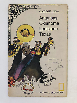
$5.49 Shipping Location: Georgetown, United States Template By Froo! National Geographic Map- 1974 Close-Up USA Oklahoma Texas Louisiana Arkansas National Geographic Map- 1974 Close-Up USA Oklahoma Texas ... moreLouisiana Arkansas Vintage 1974 two sided map Close-Up USA. Map shows Oklahoma, Louisiana, Arkansas, and Texas. The opposite side includes lots of historical information on the area by National Geographic Society. The map measures approx 35" x 23" in size. Never Unfolded. Shipping: All orders are carefully packaged. With a(Handle With Care Sticker) on the packaging. All orders ship the same or next business day. We ship orders Monday to Saturday. Orders placed before 2 pm(CST) on Fridays will ship on Saturday. We ship all orders via the United States Postal Service: First Class. Media Mail, Parcel Post, or Priority Mail, all include tracking numbers. Multi-Item Orders: We do combine shipping costs on multi-item orders. In order to receive the best shipping cost possible for your specific order please place your order. But before paying, request an invoice from us with combined shipping. We will return to you an adjusted invoice with the best shipping price for your order. Return Policy: Refunds given as money back or exchange(buyer’s choice) The buyer must pay return shipping. Please contact me within 14 days after receiving the item. Privacy Policy: Our company will never share your personal information in any way with an outside company. Our company will not send you unsolicited advertisements. Most reasonable offers are accepted. PayPal only. Please. Payment is expected within 2 days of auction end; immediate payment if you use Buy It Now. I will try and answer any questions. I am not an expert on anything I sell. And do my best to describe each item accurately. I buy many different items for the purpose of reselling them here on ebay. Any descriptions I give indicating the condition of item(s) such as: vintage. Antique, excellent, very good, good, and poor, or levels of functioning are purely subjective to what I observe, test and think of the item.
Buy It Now
Free Shipping Location: Marana, United States This Map was removed from a 1911 Atlas and is in good acceptable condition. ~ CRAM1911/021021. Including Hundreds of RareCivil War. the page edges, foxing, ... morespots, paper browning & brittle paper from over.
Free Shipping Location: Carefree, United States ORIGINAL 1843 ANTIQUE HAND-COLORED MAP OF THE SOUTHERN STATES. RARE AND VERY DETAILED MAP OF THE SOUTHERN STATES WITH GEORGIA, ALABAMA, MISSISSIPPI, LOUISIANA, ... moreARKANSAS, TENNESSEE AND PART OF NORTH FLORIDA AND NORTH CAROLINA.
Buy It Now
Free Shipping Location: Orlando, United States This map is from the Winston's Encyclopedia 1928.
Buy It Now
$4.50 Shipping Location: United States Huge, gorgeous, antique 1890 color lithographed map, very fine period lithography, superb colors and printed on thick paper, titled Arkansas. The map ... moreis large and very detailed. The size of the map is a very large 22" by 28".
Buy It Now
$5.00 Shipping Location: League City, United States This map has been carefully removed from the atlas it originally appeared it and is perfect for display purposes. It may have writing or other images ... moreon the reverse side of it. It is in very good condition for its age with overall tonal aging and yellowing on the edges.
Buy It Now
Free Shipping Location: Old Orchard Beach, United States This Map was removed from a 1882 Atlas and is in good acceptable condition. Including Hundreds of RareCivil War. 130+ years of aging. Study the photos ... morecarefully, this is the actual map you. will receive.
Buy It Now
$3.50 Shipping Location: Dover, United States Solgohachia Quadrangle Arkansas 7.5 Minute Series. Year Published: 1963. The map in the photo is the actual map you will receive.
Buy It Now
$5.00 Shipping Location: Canada DATE OF ISSUE: 1958. ORIGIN OF THE MAP: "Collier's World Atlas and Gazetteer", P. F. Collier & Son Corp., New York, USA.
Buy It Now
$5.75 Shipping Location: Malden, United States Great OLD Map from the "COLLIER'S WORLD ATLAS & GAZETTEER". It Is Lightly Yellowed From Age, As Expected. 80 Years Old! NOT A COPY! Great Detail! Very ... moreEducational. See What These States used to look like!
Buy It Now
Free Shipping Location: Augusta, United States "An Authentic Original Map Not A Reproduction".
Buy It Now
$13.71 Shipping Location: MANCHESTER, United Kingdom Beautiful large antique map on quality paper Very Good condition and rescued from a disbound Atlas: BLACK'S GENERAL ATLAS OF THE WORLD 1897. THIS ... moreSUPERB VICTORIAN MAP IS AN ORIGINAL- OVER 115 YEARS OLD*FEATURES SUPERB DETAIL* Published by Adam& Charles Black. London. This single map measures approximately 17 1/2 inches by 12 inches(445mm x 305mm) Please message with any questions regarding this item. BEST OFFERS PLEASE FOR A QUICK SALE AT A FAIR PRICE If you like the item. But do not like the price, then make a realistic offer to us using the MAKE OFFER BUTTON. Powered by
|
|
|
In
|
ARKANSAS State Map Postcard 1960's
ARKANSAS State Map Postcard 1960's Shipping and Payment Information | Condition | Scan& Info(Click to Enlarge) Description A Vintage Divided Postcard of ARKANSAS STATE MAP. Published by OZARK POSTCARD PUBLISHERS. MO. The postcard was never Postally used. There is no correspondence on back of postcard. NO OTHER INFORMATION AVAILABLE. Shipping and Payment Information Buyer to pay $1.25 in the US. $1.75: in CANADA. $2.00: INTERNATIONAL, Shipping and handling for this item, $0.25: shipping per auction to add additional auctions to the initial shipping charge. All our cards ship in either a card stiffened envelope. Or Rigid Shipping Envelope. We accept Paypal and other forms of Payment. Request info. All packages valued at $12 and up get Tracking# Condition This is a Vintage Original Postcard. Trade Card, or Photograph, all the cards we ... moresell are in VG or better condition, there are no tears or creases, unless otherwise noted in the item description. All the postcards listed are STANDARD SIZE CARDS 5 1/2" by 3 1/2" unless otherwise noted. If not satisfied, we will gladly refund. All the postcards we sell are original vintage postcards or photographs, no reproductions. Scan& Info The scan is an accurate true color scan. But reduced resolution from original item that you will receive. We post all known info we have about the card in the description. PLEASE NOTE, our scanner software sometimes cuts off the edge of cards in the scan, the cards have NOT been trimmed. The MATCHSETS watermark is on the scan only NOT on the item you will receive.
|
|
|
Texas Map & Arkansas Map on reverse 1885 Rand McNally - 6 Color Maps
Original Maps of Texas. And Arkansas, published by Rand McNally, Atlas of the World, and dated 1895. They are a 5 color map, yellow, pink, green, orange, and gray, with a dark pink outline, they measure about 9" x 12 1/4, and the map without the margins measures about 7" x 9 1/2. This is heavy paper, the map on the reverse side cannot be seen on the other side, and they are in excellent, clean condition with no foxing. See more maps in my fixed price/store listings in the category, other paper. Please E-mail me with any questions. Shipping is FREE in U.S.A. California buyer pays sales tax. SATISFACTION GUARANTEED!
|
|
|
1895 ANTIQUE MAP: ARKANSAS RIVER, SUGAR LOAF RESERVOIR
1895 MAP: ARKANSAS RIVER. SUGAR LOAF RESERVOIR. PLATE CLII. PUBLISHED BY THE GOVERNMENT PRINTING OFFICE. WASHINGTON, DC. Size: Approx 7.5 X 11 INCHES. Condition: VERY GOOD. SEE PHOTO. Please view the photos to make your own assessment. Returns: Any item may be returned for a refund. Please contact us within 7 days of receipt of your item if you feel an error has been made. We do not deal in reproductions. All of our prints our original and authentic. Please browse other prints at our store. inkfrog terapeak. I000000.
|
|
|
1895 ANTIQUE MAP: ARKANSAS RIVER BASIN HAYDEN RESERVOIR
1895 MAP: ARKANSAS RIVER BASIN HAYDEN RESERVOIR. PLATE CLIV. PUBLISHED BY THE GOVERNMENT PRINTING OFFICE. WASHINGTON, DC. Size: Approx 7.5 X 11 INCHES. Condition: VERY GOOD. SEE PHOTO. Please view the photos to make your own assessment. Returns: Any item may be returned for a refund. Please contact us within 7 days of receipt of your item if you feel an error has been made. We do not deal in reproductions. All of our prints our original and authentic. Please browse other prints at our store. inkfrog terapeak. I000000.
|
|
|
1895 MAP: ARKANSAS RIVER, TENNESSEE PARK RESERVOIR
1895 MAP: ARKANSAS RIVER BASIN. TENNESSEE PARK RESERVOIR. PLATE CLIII. PUBLISHED BY THE GOVERNMENT PRINTING OFFICE. WASHINGTON, DC. Size: Approx 7.5 X 11 INCHES. Condition: VERY GOOD. SEE PHOTO. Please view the photos to make your own assessment. Returns: Any item may be returned for a refund. Please contact us within 7 days of receipt of your item if you feel an error has been made. We do not deal in reproductions. All of our prints our original and authentic. Please browse other prints at our store. inkfrog terapeak. I000000.
|
|
|
1895 MAP: ARKANSAS RIVER, BASIN MONUMENT RESERVOIR
1895 MAP: ARKANSAS RIVER. BASIN MONUMENT RESERVOIR. PLATE CL. PUBLISHED BY THE GOVERNMENT PRINTING OFFICE. WASHINGTON, DC. Size: Approx 7.5 X 11 INCHES. Condition: VERY GOOD. SEE PHOTO. Please view the photos to make your own assessment. Returns: Any item may be returned for a refund. Please contact us within 7 days of receipt of your item if you feel an error has been made. We do not deal in reproductions. All of our prints our original and authentic. Please browse other prints at our store. inkfrog terapeak. I000000.
|
|
|
1901 SMALL ANTIQUE MAP: ARKANSAS RIVER NEAR MOORE'S ROCKS.
1901 MAP: ARKANSAS RIVER NEAR MOORE'S ROCKS OVER 100 YEARS OLD. PUBLISHED BY THE GOVERNMENT PRINTING OFFICE. WASHINGTON, DC. Size: Approx 8.5 X 5.5 INCHES. Condition: VERY GOOD. SEE PHOTO. Please view the photos to make your own assessment. Returns: Any item may be returned for a refund. Please contact us within 7 days of receipt of your item if you feel an error has been made. We do not deal in reproductions. All of our prints our original and authentic. Please browse other prints at our store. inkfrog terapeak. I000000.
|
|
|
Shell Road Map of Arkansas Louisiana & Mississippi
Shell Oil Road Map of Arkansas.Louisiana& Mississippi 1971 Edition Made by The H.M. Gousha Company San Jose Caif.
|
|
|
VINTAGE GULF OIL ROAD MAP TOURGIDE ARKANSAS, LOUISIANA, MISSISSIPPI 1950's
Vintage Gulf Oil Company Tourgide Map for the states of ARKANSAS. LOUISIANA and MISSISSIPPI. It is believed this map dates from the mid-1950's as the populations shown are from the 1950 census. The map is in very good like new condition. No rips. Tears, pin holes, writing, etc. Please email if you have any questions. I am always willing to combine postage if possible.
|
|
|
1927 Arkansas Large Commercial Auto Road map* Paved, Improved, State Hwys., etc
1927 Arkansas Large Commercial Auto Road map* Paved. Improved, State Hwys. etc Original and Large 1927 Arkansas Commercial Automobile Road Map. A Arkansas Railroad/Mileage map is on the back This is an ORIGINAL. 1927 Black& White Undated COMMERCIAL MAP.NOT A REPRINT. that measures 20 1/2" x 14" with the borders and would look fantastic matted and framed. The map shows the Paved Roads. Improved Roads, Unimproved Roads, State Highways, Trail and Highway Markings, etc. The map also shows towns and the distances between some towns. It shows some points of interest. geographic features. Rivers. Etc. Great, Historic Item. NOTE CONDITION: The map has some light border and corner wear, Otherwise. It is in Nice Condition. Please see the attached photo to view the Map and a couple of closeup sections of the map* Please note that the map ... moreis too large for my scanner.also. All of the printing is much clearer than the scan illustrates; roads, towns, etc. are very clear and readable even for an old blind guy like me* Purchase this vintage old Arkansas road map for only $21.95. U.S. Buyer pays $3.00 for shipping. $4.00 shipping to Canada; $6.00 to Europe. 1-4 maps can be combined to save on shipping. PLEASE READ: This is an original 1927 Commercial atlas road map. I prefer satisfied customers and try to accurately describe all of my maps and Ebay items so there is not any misunderstandings.If you have any questions about this map or any of my Ebay items. Please email me before bidding.Thanks! 052312 Ark27.1(R) Please Visit My Ebay Store To View My Arkansas. Mississippi, Florida, Georgia, Alabama, Carolinas And Other Vintage Maps. Thanks for looking! ALL INTERNATIONAL BUYERS PLEASE READ: Please be aware that some packages going into Canada. The UK and France are taking a very long time for delivery.2-weeks in some cases. Although I mail them as quickly as I can.I have no control over how long it takes for them to be delivered after I mail them.Also, These old maps are shipped in stu
|
|
|
Large Original 119-yr-old Antique Civil War Map TEXAS Arkansas INDIAN TERRITORY
Original Plate of"The Official Atlas to Accompany the Official Records of the Union and Confederate Armies. Published by the Resolution of the U.S. Congress of May 19. 1864 as The Official Historical Record of The Civil War, and was Never Openly Sold, but Distributed only to Federal Depositories, University Libraries, Public Museums, various Public& Semi-Public Concerns, And of Which Fewer Than 1.000 Complete Atlases Remain. Fine Adornment of Civil War History. Impressive on Any Home or Office Wall. Imaginative& Creative Gift. Civil War Topographical Map of 1865 Texas. Arkansas& Indian Territory Showing Portions of North Texas. Eastern Indian Territory, Western Arkansas. Original Plate of The Official Atlas to Accompany The Official Records of The Union& Confederate Armies. 175 Plates Issued in 35 Parts. Part 32. Plate ... moreCLIX. Original Plate CLIX(159) of the 175 Issued. Original 1894. 119-ys-old. Map is in Good Condition: No writings or marks. Mild foxing along fold indentation. Nominal fraying along edge. Short closed separation at fold indentation. Single fold as Issued. Not a Reproduction. Original Plate CLIX(159) of the 175 Issued of The Atlas to Accompany the Official Records of the Union& Confederate Armies. Commissioned by a Resolution of Congress of May 19, 1864, Published Under the Direction of the Hon. Daniel S. Lamont, Secretary of War, by Major George B. Davis, Leslie J. Perry, and Joseph W. Kirkley, Board of Publications. Compiled by Calvin D. Cowles, 23rd Infantry, Washington, D.C. Government Printing Office, 1894; a copy of the Preface, Part Volume, Title Page of which is Included. Engraved by Julius Bien& Co. Lithographers. An Exceptional Map for the Collector or Makes Quite an Impressionable Gift for Someone Living in or From Oklahoma, Texas, or Arkansas. I Sell Only Original Maps: No copies or reproductions. Press Here to View My Collection. Impressive on Any Home or Office Wall. Dimensions: 18" x 29.5" So Large It Makes Itself The Conversation of Any Room. G
|
|
|
1924 RADIO STATION MAP MINNESOTA MISSOURI ARKANSAS LOUISIANA MISSISSIPPI OHIO
This is a huge BLACK& WHITE COPY(NO COLOR) of an original 1924 map titled: RADIO BROADCASTING STATIONS of the UNITED STATES Showing Calls and Divisions of Time- Map is MUCH SHARPER than images shown. This map is HUGE-36 inches by 24 inches! Check out the very first RADIO STATIONS of the United States! Check out how the TIME ZONES have changed since 1924! I will mail out in a large mailing tube. I accept PAYPAL and peronal checks. This RARE MAP would make a great gift! Can't Beat the Price for this GIGANTIC MAP! Thanks for looking!
|
|
|
Civil War Map - Island No. 10 New Madrid Missouri Pea Ridge Arkansas Shiloh
Lake Erie Maps& Prints Union Positions in Blue and Confederate in Red An Original Antique Map: Not a Reproduction! Plate X Atlas to Accompany the Official Records of the Union and Confederate Armies Currently Listing Many Civil War Maps and Prints Check out my! Title of Maps: 1) Island No. 10. 2) Route from Keetsville to Fayetteville. Arkansas. 3) Battle of Pea Ridge. 4) Route of Major Conrad from Bentonville to Cassville, Missouri. 5-6) Pea Ridge. 7) Rebel Positions at Centreville. 8) battle of Lee Town. 9) Manassa Junction, VA. 10) Shiloh near Pittsburg Landing, Tennessee. Description: It is an original map from the Atlas to Accompany the Official Records of the Union and Confederate Armies. Published by the Secretary of War, Washington: Government Printing Office, 1891-1895) undoubtedly the most complete set of accurate maps of the ... moreCivil War ever published. The title of the atlas appears in the top left margin and plate number in the upper right. A copy of the title page is included with all the publishing details for authenticity. The atlas was published in a very limited context to be distributed to government officials in the three houses of government as a reference for assessing the Civil War. This is from the original first publishing, that lasted from 1891-5. In general, these maps are very detailed showing lines of approach, battle formations, forts, batteries, dates, various armies and officers involved, topography down to houses in many cases and other details and historical notes. The Union lines are in blue and the Confederate in Red. A very beautiful map that will frame up nicely! Size: The map image measures 16 by 27 inches on a page measuring approximately 18 by 29 inches with plenty of margin all around for framing. Condition: The map sheet is in Very Good to Excellent condition with overall tonal aging. Blank on the reverse and printed on heavy paper with a centerfold as issued. There is some cockling along the right edge, margin only, otherwise it is very clean and would frame up nicely
|
|
|
Arkansas State Map Coffee trade card,1889,Sawing Lumber, cotton Gin.
Very nice condition: 1889: Lithographed by the Donaldson Bros. Newyork City.NY. 9014stacey
|
|
|
1864 Original Huge Civil War Map Louisiana, Arkansas, Mississippi
Original hand colored engraving as issued. Dated in the plate. Published by Johnson& Ward. Entered into US Congress by A.J. Johnson. 1865. Image area is 17.5" w X 24.0"h. including decorative border. Interesting and very detailed Civil War County and Railroad Map. Shows chief cities. County seats, and road system. Beautifully executed. Attractive hand color, will frame nicely. Overall good condition with mild ageing. Centerfold has been reinforced with acid free material and some typical small marginal tears well away from the image have been mended with acid free material. Left margin has an old tape repair. See photos. Low starting bid with no reserve. Shipping cost is for insured domestic priority mail.
|
|
|
1833 SDUK: Map of Missouri, Arkansas, Mississippi, Tennessee...(North America X)
Fine. Original, steel-engraved map of parts of Missouri, Arkansas, Mississippi, Tennessee, Kentucky, Alabama, and Illinois, North America X, by the Society for the Diffusion of Useful Knowledge(SDUK) published as part of the Society's Atlas in 1844, in London, by Chapman and Hall. The SDUK began its map publishing project under the leadership of Captain Francis Beaufort R.N. in 1829, and published the maps in parts, haltingly, over the next 15 years, completing the series in 1844, finally permitting the publication of a whole atlas. Many of the maps were actually drawn by Beaufort, who at the time was the Hydrographer to the Royal Navy, and all were closely supervised by him. J. C. Walker worked closely with Beaufort in engraving the maps. Finely engraved, and carefully researched, the maps set a standard of excellence for commercial ... moremap-makers in England for decades to come. Dimensions 16" x 13 1/4" overall. Minor browning to edges, otherwise excellent condition.
|
|
|
Original 1890 Antique Hunt & Eaton Map LOUISIANA ARKANSAS MISSISSIPPI
Fine Adornment of History. Imaginative& Creative Gift for Someone Living in or From Louisiana. Mississippi, Arkansas. 1890 Map of Louisiana. Mississippi, Arkansas Fine Hunt& Eaton Map. Engraved by E.F. Fisk. Original 1890. 122-ys-old. Map is in Very Good condition: No marks. Writings, rips, tears, fraying, or foxing. Single fold as Issued. Not a Reproduction. Original Map Drawn& Engraved by E.F. Fisk for Hunt& Eaton's 1890 Edition of The People's Cyclopaedia of Universal Knowledge. Published by Hunt& Eaton, New York& San Francisco, 1890; Edited by William H. Dupuy. E.F. Fisk, Engraver; a Copy of the Title Page of which is Included. An Exceptional Map for the Collector or Makes Quite An Impressionable Gift for Someone Living in or From Louisiana, Mississippi, or Arkansas. I Sell Only Original Antique Maps: No ... morecopies or reproductions. Press Here to View My Collection. Impressive On Any Home or Office Wall. Dimensions: 10.75" x 13" Beautiful Color. Intricate Detail. E.F. Fisk Engraved. Great for Family History as Map Shows Towns& Landmarks of 1890. Some of which No Longer Exist Today. 1890 Population of Counties on Reverse. Imaginative& Creative Birthday. Christmas, Graduation, or Other Special Occasion Gift. The Auction is for the Map Itself. A Frame is Not Included. The Framed Map Pictured is a Personal 1890 Hunt& Eaton Map Featured to Show the Beauty of the Maps when Framed. Free Shipping Special. All Credit& Debit Cards& Electronic Checks Accepted Through Paypal. Please email with any questions. Fine Adornment of Louisiana. Mississippi, Arkansas History. Greetings from Historical Savannah. Georgia; founded 1733. Some. To beautify their halls, parlors, chambers, or libraries.loveth, getteth, and useth maps, charts, geographical globes. John Dee. Advisor to Elizabeth I. Press The Store Link Below To View My Collection. Powered by The free listing tool. List your items fast and easy and manage your active items.
|
|
|
L565 JOHNSON 1886 STEEL ENGRAVED MAP ARKANSAS MISSISSIPPI LOUISIANA HAND COLORED
LOT# 565 Detailed Photos. Click to enlarge. Estate Road Show. Item Description. We are pleased to offer this authentic steel engraved c.1886 Johnsons Map of Arkansas. Mississippi and Louisiana. This Hand Colored Atlas Map features local districts divided by color as well as railways, swamps, mountains and roads. This is from the 1886 edition of Johnsons Family Atlas, originally published in 1866. This later edition map features the desirable banknote border and publisher information in the title block. Johnsons maps are highly sought by collectors for the detail and vivid coloring and this map is no exception. It is professionally matted and framed and in excellent condition. REFERENCES UTILIZED: Antique Maps by Douglas Gohm G225Investment grade art, posters, silver from Cashiers NC estate collection all carefully appraised and reviewed, ... moreformal appraisal available for $50. Shipping can be combined but sometimes eBay calculator cannot estimate accurately- we send by UPS at cost +$3 per box, wait for our invoice. Retail Value Estimate: $375-$425 Condition: No damage Weight: 6lb Measurements(LxWxH) 26 inches x 1 inches x 32 inches Estate Road Show. 36`.RcmdId ViewItemDescV4,RlogId p4%60bo7%60jtb9%3Fuk.rp*70%60%3E36%60-13d7e29dae3-0xf6-
|
|
|
1893 ORIGINAL ANTIQUE MAP OF ARKANSAS
1893 ORIGINAL ANTIQUE MAP OF ARKANSAS This original antique map gives you an opportunity to examine in exquisite detail a piece of history. If you are interested in the past of this country and its people or have a desire to study where your family may have come from. Then this map gives you a rare look as the area was about 117 years ago. Once matted and framed, this map would make a perfect gift for a family member or friend they'll cherish forever. Origin of the map: International Office and Family Atlas of the World" Published by John F. Waite. Chicago, USA. Date of issue: 1893 Size: The sheet measures 14 1/4" x 11" 36 x 28 cm) S/H: The map will be shipped by Air Mail. The shipping charge is: USA- 6.50 USD. World- 7.50 USD, Canada- 7.50 USD. The price includes the insurance and a strong, cardboard tube with plastic ... moreplugs. Attention! There is no additional shipping charge for multiple purchases! Pay me securely with any major credit card through PayPal! Payment methods: US/Canada Buyers: Paypal. International Buyers: Paypal. Click Here. Double your traffic. Get Vendio Gallery- Now FREE!
|
|
|
1892 ANTIQUE MAP OF ARKANSAS
1892 MAP OF ARKANSAS This original antique map gives you an opportunity to examine in exquisite detail a piece of history. If you are interested in the past of this country and its people or have a desire to study where your family may have come from. Then this map gives you a rare look as the area was about 117 years ago. Once matted and framed, this map would make a perfect gift for a family member or friend they'll cherish forever. Origin of the map: The People's Illustrated and Descriptive Family Atlas of the World" Published by R. S. Peale. Chicago, USA. Date of issue: 1892 Size: The sheet measures 37 x 27 cm(14 1/2" x 10 3/4" S/H: The map will be shipped by Air Mail. The shipping charge is: USA- 7.50. World/Canada- 8.50. The price includes the insurance and a strong, cardboard tube with plastic plugs. Attention! ... moreThere is no additional shipping charge for multiple purchases! Pay me securely with any major credit card through PayPal! Payment methods: US/Canada Buyers: Paypal. International Buyers: Paypal. Click Here. Double your traffic. Get Vendio Gallery- Now FREE!
|
|
|
1889 ANTIQUE MAP OF LOUISIANA / ARKANSAS
1889 ANTIQUE MAP OF LOUISIANA/ ARKANSAS This original antique map gives you an opportunity to examine in exquisite detail a piece of history. If you are interested in the past of this country and its people or have a desire to study where your family may have come from. Then this map gives you a rare look as the area was about 120 years ago.Once matted and framed, this map would make a perfect gift for a family member or friend they'll cherish forever. Origin of the map: The Scribner-Black Atlas of the World" Published in New York by Charles Scribner's Sons(Edinburgh: Adam and Charles Black) Date of issue: 1889 Size: The whole sheet measures 17 1/2" x 12" 45 x 31 cm) S/H: The map will be shipped by Air Mail. The shipping charge is: USA- 7.50 USD. World- 8.50 USD, Canada- 8.50 USD. The price includes the insurance and ... morea strong, cardboard tube with plastic plugs. Attention! There is no additional shipping charge for multiple purchases! Pay me securely with any major credit card through PayPal! Payment methods: US/Canada Buyers: Paypal. International Buyers: Paypal. Click Here. Double your traffic. Get Vendio Gallery- Now FREE!
|
|
|
1902 DATED MAP OF ARKANSAS VER
1902 DATED MAP OF ARKANSAS This original antique map gives you an opportunity to examine in exquisite detail a piece of history. If you are interested in the past of this country and its people or have a desire to study where your family may have come from. Then this map gives you a rare look as the area was about 100 years ago. Once matted and framed, this map would make a perfect gift for a family member or friend they'll cherish forever. Origin of the map: Encyclopaedia Britannica. Tenth Edition, published by Adam& Charles Black, Edinburgh& London, UK under license of The Century Company, New York, USA. Date of issue: 1902 Size: The sheet measures 16.25" x 11 1/2" 41 x 29 cm) BOTTOM CORNER FOLDED. S/H: The map will be shipped by Air Mail. The shipping charge is: USA- 6.50. World- 7.50. The price includes the insurance ... moreand a strong, cardboard tube with plastic plugs. Canada- the map will be shipped by Air Mail as a Letter. The shipping charge is: 2.50 USD. The price includes a strong, secure envelope. Attention! There is no additional shipping charge for multiple purchases! Pay me securely with any major credit card through PayPal! Payment methods: US/Canada Buyers: Paypal. International Buyers: Paypal. Click Here. Double your traffic. Get Vendio Gallery- Now FREE!
|
|
|
1900 Original Antique Map ARKANSAS ....113 Yrs old
The map measures approx. 3 x 5 inches The map is in good condition. Clean, no stains, no markings and would frame nicely Check out my STORE for a great selection of maps
|
|
|
2008 Arkansas Map The Natural State - A Piece of History
This Auction is for 2008 Arkansas Map- The Natural State- A Piece of History Item# 1506 Payments Accepted by PayPal
|
|
|
ARKANSAS authentic Antique Map with COA genuine 115 years old made in 1898
This scan is enlarged to show representative detail. ARKANSAS Authentic 115-Year-Old Antique Map FREE SHIPPING ANYWHERE IN THE USA! Printed in 1898. This is a beautiful, 115-year-old full color map of the State of Arkansas. It measures about 10 by 14 inches and is in Fine condition. This map contains a wealth of old detail including latitude and longitude, topographical features, counties, cities and villages, routes of old railroads, and more. There are even a few ghost towns, no longer in existence today. This is a guaranteed genuine antique map! It ships complete with Certificate of Authenticity documenting source. Maker and date of printing. Ideal for genealogy or other historical research. This map was printed on a single sheet of stock, hinged in the center and blank on the reverse, and bound whole in an antique book. There are no marks ... moreor stains, and the paper is clean and not brittle. Highly suitable for framing, this map would look great in your office, library, den or study. It is similar to many of the maps sold in expensive mail-order catalogues and department stores, with one important difference: this is an actual antique. NOT a modern reproduction. An excellent investment. This map is certain to appreciate in value over time. Please ask all questions before making your purchase. FREE SHIPPING within the USA by USPS First Class Mail. Priority and Express services also available. We ship worldwide! caeb98
|
|
|
1864 Johnson Map - Louisiana Arkansas Mississippi Gulf
Lake Erie Maps& Prints! An Original Antique Map: Not a Reproduction! See Our Ebay Store for More! Free Shipping on Purchases of 5 or More Maps and Prints Description: It is an authentic engraved antique Civil War era map with original handcoloring and the desirable decorative border. It is from the 1864 Edition of Johnson's Family Atlashas a copyright date of 1864 printed on the map. A copy of the title page is included for authenticity. It is not matted nor framed being sold as a single sheet as shown in the main pic. Size: The map image measures approximately 17 1/2 by 24 inches on a 18 by 26" page and a margin all around for framing. Condition: The map is in Fair to Good condition with overall tonal aging and original hand color with a centerfold as issued. The centerfold was splitting and has been reinforced on the reverse. ... moreSo it no longer folds but is very good for framing. There is some minor dampstains on the edge, a couple of very light smudges and slightly bent corner, otherwise it is very clean with nice strong color that would frame up well. The pics are of the actual map. Payment Details: We accept most major credit cards through Paypal and Ebay. Please ask if you have any questions about payment. International and New Bidders are welcomed and encouraged. Payment is expected within 7 days. After which Nonpaying Bidders will be reported to Ebay to recoup our listing fees. Shipping: $3.50 for First Class or $4.95 for Priority Mail with Delivery Confirmation in the USA; $4.95 for First Class International to Canada; $8 for International Airmail elsewhere in the World or $23 for Priority International. Which includes Paypal insurance. We ship daily, so if still bidding send us a quick email to hold or better just pay all at once at the end. Save on Shipping: We only charge one shipping fee based on the largest map or print with multiple items shipped along with it for no extra costs. Purchase 5 or more maps or prints and receive Free First Class shipping in USA or First Class International el
|
|
|
1893 colored Columbian Atlas page original map Arkansas Louisana Mississippi
Map page from the 1893 Columbian Atlas of the World We Live In- M ap of Arkansas Louisana Mississippi tri-state region page measures 11-1/2" X 14" + + + There is some typical darkening from age and handling around the edges of the pages. But overall in good condition for a document that was printed 119 years ago! All of my maps are originals. I do not destroy good books. But rescue pages from damaged and ruined atlases. I mail maps rolled up in shipping tubes for protection. Which I have found to be the best way to get the item delivered without shipping damage. Buyer pays for shipping outside the US. So check before bidding. If you cannot find the map you are looking for. Let me know. I have about a thousand old– city– state– region– territory– country– maps that are not yet listed. If you don't like your purchase. It can be ... morereturned. + + + Ask any questions.
|
|
|
1923 color map, Louisiana / Arkansas, 5 x 7"
Color maps from The Little Giant Atlas of the World C.S. Hammond& Company New York. 1923 map size approx. 5 x 7" page size approx. 6 x 8" condition good/fair. Any reflection in photo is from plastic sheet protector Thanks for looking! I am not a map dealer. I bought this book many years ago. Already partially disassembled, to get a few maps that I wanted for myself and gifts. Am now selling the rest.
|
|
|
1902 Antique Map Arkansas Railroad Lines County City Town Topography Vintage
Atlas Plate#44: Arkansas Original 1902(revised from 1897) Atlas Plate from a Century Atlas prepared under the supervision of Benjamin E. Smith and engraved by The Matthews-Northrup Works. Buffalo and New York. Details may include: railroad lines in red- counties- cities- towns- battles- height of land and depth of water- historic landmarks- etc. Condition good or better for 111 year old paper: may have very light edge soiling- back is blank except for plate number and description. Map measures 16 1/4 wide and 11 3/4 inches tall with fold in center. If you need more info or have any questions please contact us Shipping and handling charge = FREE Shipped via USPS Mail with Delivery Confirmation/Tracking SHIPPING MONDAY THRU FRIDAY ONLY Be sure to checkout the other great items we are offering Just a quick note to thank you for checking out ... moreour item and to let you know alittle about us We are Karen and John. Wife and husband from the beautiful Lakes Region of New Hampshire We have been sellers since 1999 making some extra money and finding homes for interesting items We use different names to sort the items we offer that way we can be somewhat organized! Our names are IBEEBACK. IBEADULT, and SHOPNH4U And our items can be found by doing an advanced search by seller name You can also review our feedback files and ME page for more info how we treat all sales We hope we can do business with you soon. Karen and John inkfrog terapeak. InkFrog Analytics.
|
|
|
1928 Arkansas Large Commercial Auto Road map* Dirt, Paved, Improved, Graded, et
1928 Arkansas Large Commercial Auto Road map* Dirt. Paved, Improved, Graded, et Original and Large 1928 Arkansas Commercial Automobile Road Map. Smaller Arkansas Railroad map is on the back. This is an ORIGINAL. 1928 Black& White Undated COMMERCIAL MAP.NOT A REPRINT. that measures 20 1/2" x 14" with the borders and would look fantastic matted and framed. The map shows the Dirt Roads. Graded roads, Paved Roads, Improved Roads, State Highways, etc. The map also shows towns and the distances between towns. It shows some points of interest. geographic features. Lakes. Rivers, etc. Great, Historic Item. A smaller black& white Arkansas railroad map is on the back(see the scan for a section of that map) Also. A list of 1920 Arkansas Industrial Stats is on the back; County populations by race, number of farms, wages, live stock, ... moreetc. NOTE CONDITION: The map has lite border and corner wear. Otherwise. It is in Nice Condition. Please see the attached photo to view the Map and a couple of closeup sections of the map plus a section of the railroad map on the back* Please note that the map is too large for my scanner.also. All of the printing is much clearer than the scan illustrates; roads, towns, etc. are very clear and readable even for an old blind guy like me* Minimum bid for this vintage old road map for only $19.95 or purchase it for $24.95. U.S. Buyer pays $3.00 for shipping. 1-4 maps can be combined to save on shipping. NO INTERNATIONAL SHIPPING! PLEASE READ: This is an original 1928 Commercial atlas road map.I prefer satisfied customers and try to accurately describe all of my maps and Ebay items so there is not any misunderstandings.If you have any questions about this map or any of my Ebay items. Please email me before bidding.Thanks! 0 20513 Ark28. 2(R) Please Visit My Ebay Store To View My Arkansas. Mississippi, Florida, North& South Carolina, Georgia, Alabama And Other Vintage Maps. Thanks for looking! NO INTERNATIONAL SHIPPING! Thanks for your understanding!
|
|
|
1907 Arkansas Map of Bank Towns JW White Co Antique Bankers Advertising Map
Click to Enlarge Click to Enlarge Click to Enlarge This is an original antique map of Arkansas showing the location of Bank Towns. This map is printed in color with bank advertising in the margin around the map and on the verso. This map measures about 16.5” x 11.5” and is printed“ Copyright 1907. By J.W. White– O Indicates Location Of Bank Towns” This map has small red circles on each town with a bank in the state. This map came with other similar maps for other states which also showed the location of bank towns within the respective states. I believe this map was part of an bankers’ atlas or portfolio of maps showing bank towns that was originally published by the Bankers Register. The maps included a national map of the United States which had advertising on the verso for the Bankers Register. This map has advertising for Benton County ... moreNational Bank. The Bank of Springdale, First National Bank of Helena, Citizens Bank of VanBuren and others. This colorful map is an original antique published 105 years ago in very good condition and is very suitable for framing or display. Email any questions. Thanks for looking. Please see the Maps category in my eBay store for more maps including antique Bank Town maps for other states. Payment Terms Winning bidders will receive an email at the end of the auction explaining the option for paying with Paypal. If you have questions about how to pay for this item please let me know. If you made multiple purchases for a single shipment contact us for combined shipping charges which will normally be less than the amount shown on Paypal invoice. You will receive an email notifying you when your item ships. Buyers outside the USA. Please provide a telephone number for customs forms. Shipping Terms Please click on the Shipping& Payment tab above to access the eBay shipping calculator which will give you the options and costs for shipping your item depending on your zip code or country. Our shipping charges are based on actual postage plus less than one dollar to cover material
|
|
|
ARKANSAS authentic WW2 Vintage Map genuine 74 years old made in 1939
ARKANSAS Authentic 74-Year-Old Vintage Map Made During World War II FREE SHIPPING ANYWHERE IN THE USA! Printed in 1939. This is a beautiful, 74-year-old map of the State of Arkansas. It measures about 10 3/4 by 14 1/4 inches(about 27 by 36 cm. and is in Fine condition. The map contains a wealth of detail including latitude and longitude, topographical features, counties, cities and villages, routes of old railroads, and more. A detailed index to cities and villages is printed in the margin. This is a guaranteed genuine vintage map! Ideal for genealogy or historical research. This map was printed on a single sheet of stock and bound whole in an antique book. There are no folds or creases, and the paper is clean and not brittle. Highly suitable for framing, this map would look great in your office, library, den or study. It is similar to many ... moreof the maps sold in expensive mail-order catalogues and department stores, with one important difference: this is an actual antique. NOT a modern reproduction. A great investment. This map is certain to appreciate in value over time. Please ask all questions before making your purchase. This image is enlarged to show representative detail. FREE SHIPPING anywhere in the USA by USPS First Class Mail. Priority and Express services also available. Shipped rolled in a sturdy tube. cwag39
|
|
|
ARKANSAS authentic WWI Vintage Map genuine 98 years old made in 1915
ARKANSAS Authentic 98-Year-Old Vintage Map FREE SHIPPING ANYWHERE IN THE USA! Engraved and printed in 1915. Dimensions: about 11 1/2 by 15 inches. A guaranteed genuine vintage map! This map contains a wealth of detail including latitude and longitude. Topographical features, counties, cities and villages, newly installed electric lines, routes of old railways and more. Ideal for genealogy or other historical research, this map was printed on a single sheet of stock, and bound whole in an antique book. Highly suitable for framing, this map would look great in your office, library, den or study. It is similar to many of the maps sold in expensive mail-order catalogues and department stores, with one important difference: this is an actual antique. NOT a modern reproduction. An excellent investment. This map is certain to appreciate in value ... moreover time. Please ask all questions before making your purchase. This image is enlarged to show representative detail. FREE SHIPPING anywhere in the USA by USPS First Class Mail. Priority and Express services also available. Shipped rolled in a sturdy tube. ira15
|
|
|
1901 ANTIQUE GEOLOGICAL MAP: ARKANSAS BAUXITE DISTRICT. LITHOGRAPH MAP BY BIEN.
1901 ANTIQUE COLOR LITHOGRAPH GEOLOGICAL MAP: ARKANSAS BAUXITE DISTRICT. FROM BENTON TO LITTLE ROCK. LITHOGRAPHY BY NOTED FIRM JULIUS BIEN& CO. NY. PUBLISHED BY THE GOVERNMENT PRINTING OFFICE. WASHINGTON, DC. 1901. FROM: ANNUAL REPORT, UNITED STATES GEOLOGICAL SURVEY. Size: Approx 14.5 X 11.25 INCHES(ENTIRE SHEET) Condition: VERY GOOD. SEE PHOTO. Please view the photos to make your own assessment. ONE FOLD. AS PUBLISHED AND BOUND INTO BOOK. Returns: Any item may be returned for a refund. Please contact us within 7 days of receipt of your item if you feel an error has been made. We do not deal in modern reproductions. All of our prints& maps are original and authentic. Please browse other prints& maps at our store. Inv# m1901-21 inkfrog terapeak. I000000.
|
|
|
ARKANSAS authentic Vintage Map genuine 79 years old made in 1934
ARKANSAS Authentic 79-Year-Old Vintage Map FREE SHIPPING ANYWHERE IN THE USA! Engraved and printed in 1934 by National Map Company. Dimensions: about 11 by 15 inches. A guaranteed genuine vintage map! This map contains a wealth of detail including latitude and longitude. Topographical features, counties, cities and villages, routes of old railways and more. Ideal for genealogy or other historical research, this map was printed on a single sheet of stock, and bound whole in a loose-leaf book. A similar map of Alabama is printed on the reverse. Highly suitable for framing, this map would look great in your office, library, den or study. It is similar to many of the maps sold in expensive mail-order catalogues and department stores, with one important difference: this is an actual antique. NOT a modern reproduction. An excellent investment. ... moreThis map is certain to appreciate in value over time. Please ask all questions before making your purchase. This image is enlarged to show representative detail. FREE SHIPPING anywhere in the USA by USPS First Class Mail. Priority and Express services also available. Shipped rolled in a sturdy tube. opr34
|
|
|
Antique Kansas City Missouri & Kansas or Arkansas Map 1899 Color
This map is in very good condition. Map measures 11 x 14 inches and is suitable for framing. You are bidding on a map from a 1899 Rand McNally Atlas Of The World. Please keep in mind. If it is a two sided page, only one map can be displayed at a time. This map will be shipped wrapped in plastic reinforced with cardboard for support Thanks for looking and please be sure to visit my other auctions for more antique and vintage maps. Ads, magazines, post cards, books, and more. Powered by
|
|
|
1852 Mitchell's A New Map of Arkansas,with Canals, Roads,& Distances, (Original)
SEE ALL MY ITEMS: EBAY ADVANCE SEARCH. SELLER, mapseller01 Terms: Domestic and Overseas shipping as per prices listed on bid details. Please note: No refunds on overseas items sent without tracking. We ship within 48 hours of receipt of funds. Any questions. Please email or you can call: The Map Seller 1-858-571-2031. We only sell maps. Prints and books relating to cartography. We answer all questions in a timely manner. No reproductions unless clearly stated Additonal cartographic materials available at PS Maps.
|
|
|
Vintage Gulf Oil Co Texas, Arkansas, Louisiana and Mississippi Tourgide Map 1971
Vintage Gulf Oil Co Texas. Arkansas, Louisiana and Mississippi Tourgide Map 1971 Age wear. Very good condition. See pictures. No international shipping.
|
|
|
Texas Arkansas Louisiana Mississippi 1853 Burgess antique hand colored map
Texas Arkansas Louisiana Mississippi 1853 Burgess antique hand colored map United States: Texas. Arkansas, Mississippi, Louisiana and Indian Territory Issued 1853. New York by Burgess Fine original antique steel engraved map. Printed in the 19th century, on quality paper which retains its inherent structural flexibility and soundness. With original hand color. We notice three tall masted sailing ships within the Gulf of Mexico. Population of Texas is given as 213.000. In Fair to Good or better condition. The sheet is toned with light scattered spotting as well as some minor staining and slight wrinkling but the image is still overall very presentable and attractive[note: we grade very conservatively and always seek to disclose any noteworthy flaws] Text on verso as issued. The printed area remains visually pleasing. A nice impression of an ... moreinteresting antique USA map which will look nice when displayed. Sheet measures c. 11" H x 9" W. Printed area measures c. 10 1/8" H x 8 5/8" W. 30892] Any defects along the sheet edges and in the margins may be seen in the photos. note: All old sheets of printed paper possibly have short edge splits. Each sheet has existed for a very long time and has probably been handled repeatedly in the course of it's existence. It has a history unique to it as an object. Most of the time any edge splits are short. Minor, insignificant and have been closed- either long ago or more recently with small pieces of archival tape. Most often these splits are trivial and easy to overlook visually. Basically, they would not significantly affect the piece adversely. The item is offered as seen. Please look carefully and make your decision knowing this antique image is nice. But it is not in perfect"like new" condition. However, with whatever flaws it possesses, it remains entirely worthy of ownership and inclusion in any related collection. We feel it will prove very pleasing to its new owner. We stand behind everything we sell. Everything we offer is guaranteed to
|
|
|
1900 14.5 x 22" Map EASTERN TEXAS w/ OKLAHOMA INDIAN TERRITORY ARKANSAS Geo Cram
c. 1900 4-Color Map- EASTERN TEXAS(double page) with Oklahoma and Indian Territories. Plus Arkansas(on reverse) From a disbound copy of George F. Cram. Unrivaled Atlas of the World. Chicago& NY. 1900. Note: We did not disbind this atlas. Nor do we have the entire atlas. But we do have the front board and title page- see the last photos for reference. Interesting snapshot of the area around the turn of the 20th century. Vast areas are still largely unsettled. The Eastern Texas map shows considerable detail of the coastline. The Oklahoma and Indian Territory map shows the lands of the Kiowa and Comanche. Chickasaw, Choctaw, Pawnee and others- this was a pivitol time period for the Territory, which was not yet a State. Bi-fold double-page map printed on sturdy medium-weight stock- measures 14.5 x 22" unfolded. Map was bound in on a ... morethin paper strip. So there are no binding marks at the fold(just the fold itself) Scale plus latitude and longitude indications. Counties. Railroad lines, rivers, some landforms. List of counties and chief cities in the margin. CONDITION: Very Good Plus or better. The fold has residue of the tipped-on binding edge strip- the binding was done on this strip and the map fold is NOT perforated. Overall light uniform yellowing shading. The paper is sturdy and NOT brittle. The fold is crisp and without wear. Would frame up beautifully for display. See the detail photos. We use accepted bookseller's grading standards: Fine. Near Fine, Very Good, Good, Fair, Poor. We grade items conservatively. SHIPPING: Map is oversized- for International shipping outside the US. Please contact us for a quote. Map will be shipped folded, as it was bound in the atlas. We do our best to combine shipping for orders with multiple items. SKU08737EW. Powered by The free listing tool. List your items fast and easy and manage your active items.
|
|
|
1892 colored Crams Atlas page original map Oklahoma Indian Territory or Arkansas
Map page from the 1892 Cram's Unrivaled Atlas of the World- M ap of Oklahoma Indian Territory Guthrie is still the capital and not OK City page measures 11-1/4" X 14-1/2" The reverse side of the page is a Map of Arkansas + + + There is some typical darkening from age and handling around the edges of the pages. But overall in good condition for a document that was printed 120 years ago! There are some water stains around the edges of the page(see pictures) All of my maps are originals. I do not destroy good books. But rescue pages from damaged and ruined atlases. I mail maps rolled up in shipping tubes for protection. Which I have found to be the best way to get the item delivered without shipping damage. Buyer pays for shipping outside the US. So check before bidding. If you cannot find the map you are looking for. Let me know. ... moreI have about a thousand old– city– state– region– territory– country– maps that are not yet listed. If you don't like your purchase. It can be returned. Ask any questions.
|
|
|
1941 ANTIQUE WWII MAP OF ARIZONA / ARKANSAS ON REVERSE SIDE
1941 ANTIQUE WWII MAP OF ARIZONA/ ARKANSAS ON REVERSE SIDE This original antique map gives you an opportunity to examine in exquisite detail a piece of history. If you are interested in the past of this country and its people or have a desire to study where your family may have come from. Then this map gives you a rare look as the area was about 70 years ago. Once matted and framed, this map would make a perfect gift for a family member or friend they'll cherish forever. Origin of the map: The International Atlas of the World" Published by Geographical Publishing Company, Chicago, USA. Date of issue: 1941 Size: The sheet measures 14 1/4" x 10 1/4" 36 x 26 cm) S/H: The map will be shipped by Air Mail. The shipping charge is: USA- 7.50 USD. World/ Canada- 8.50. The price includes the insurance and a strong, cardboard tube ... morewith plastic plugs. Attention! There is no additional shipping charge for multiple purchases! Pay me securely with any major credit card through PayPal! Payment methods: US/Canada Buyers: Paypal. International Buyers: Paypal. Click Here. Double your traffic. Get Vendio Gallery- Now FREE!
|
|
|
Vintage ARKANSAS Atlas/Map from the School & Library Atlas of the World 1965
ARKANSAS" Map 1 full pages: Page 23/24(BACK TO BACK) Book page measurements are 21-3/4" high x 15" wide Carefully r emoved from the- School and Library Atlas of the World Printed and Bound in the United States of America by the School and Library Publishing Company Sycamore. Illinois Library of Congress Catalog Card Number: Map 62-216 Framable measurements would be approx. be 21" x 15" This map is in on 1 page. I'm selling many maps from this atlas and many may have minor tears. Folds, and/or spots. I'm showing the cover and title page for your information only. not included) Please ask any questions regarding before purchasing. There is plenty of surrounding border for matting purposes. Some pages have faired better than others. All and all they have survived almost 50 years. Most of the age on the pages ... moregive the maps a well worn. Aged appearance. The colors are vibrant and the maps are still readable and framable. I will be posting more maps of states and countries. If you purchase more than one map. I will combine shipping. Look at photos. Please ask questions any question prior to purchasing. Thank you. If you see a buy it now at the top click the BUY IT NOW button to get your purchase quicker. Note: This original antique map gives you an opportunity to examine in exquisite detail a piece of history. If you are interested in the past of this country and its people or have a desire to study where your family may have come from. Then this map gives you a rare look as the area was years ago. Once matted and framed, this map would make a perfect gift for a family member or friend. Most maps we sell come from atlases that were damaged and beyond repair. The maps often had a canvas book binding tape mounted on back along the center fold. Please if you are unhappy with your purchases. Please contact us before leaving feedback. Thank you.
|
|
|
1941 RAND McNALLY POCKET MAPS ARKANSAS INDEXED MAP LIST OF CITIES HIGHWAY MAP
1941 RAND McNALLY POCKET MAPS ARKANSAS INDEXED MAP LIST OF CITIES HIGHWAY MAP This is a 1941 RAND McNALLY POCKET MAPS* ARKANSAS* COMPLETE INDEXED REFERENCE MAP LIST OF CITIES- TOWNS WITH COMPLETE POPULATIONS- COUNTIES- RAILROADS- WATERWAYS- PHYSICAL FEATURES- HIGHWAY MAP" For Tourists. Travelers, Shippers- General Commercial& Busines Reference" 34 PAGE BOOK SEPARATED FROM MAP/COVERS* 19 3/4in. x 27* MAP IS MUCH BRIGHTER THAN PICTURES SHOW* CONDITION: A lot of coverwear. Chipping, creases, writing. Book part separated from covers. Paper book part yellowed. Staples clean. Map clean. PLEASE JUDGE THE PICTURES BEL OW* MYREF-E 56-02-6933* BUYER PAYS $3.00 POSTAGE WE ARE HAPPY TO COMBINE ITEMS TO SAVE MAILING COSTS PAYPAL IS REQUIRED* I HAVE BEEN SELLING ON eBAY SINCE JULY 29. 1998! Payment must be received within 7 days. PAYPAL ONLY. ... moreTHE FOLLOWING IS A READING TEST FOR BUYERS IN THE U.S.A. PLEASE read the Payment Instructions at the BOTTOM of this page. Regarding mailing costs. Please. View My Other Items For Sale SMOKING DISCLAIMER Almost all of our offerings have been in someone elses home or business prior to my purchase. We cannot assure that the previous owner did not smoke or have pets.or smoke pets. I live and work in a smoke free environment with some cats. Neither I nor my cats smoke. g=0.RcmdId ViewItemDescV4,RlogId p4%60bo7%60jtb9%3Fuk.rp*60%600%3Eg%3D0-13d85753865-0xf7-
|
|
|
Old County Maps - CALHOUN COUNTY ARKANSAS (AR) MAP BY ARKANSAS STATE HWY COMMISS
This is an exquisite full-color Reproduction printed on heavyweight(7.0 MIL) Glossy Photo Paper. These maps are perfect for framing. Or a wonderful and unique gift for family members, friends or co-workers! All Information is Carefully Compiled from Actual Surveys Original Maps are often difficult to find and usually have fold lines. Identifying stamps or markings, tears, ragged edges, and assorted other natural signs of age that detract from their beauty. All of our maps have been professionally restored to depict their original beauty, while keeping all historical data intact. These maps are fabulous pieces of history full of information useful to Historians. Genealogists, Cartographers, Relic Hunters, Others. They make fascinating conversation pieces and splendid works of art for the home or office. Map Size: 23.00 x 36.92 Site Specifics ... moreTo This Map Are: Artesian. Delhi, Hampton, Harrell, Summerville, Tinsman, Woodberry, Smead, Locust, Elberta, Ellisville, Levit, Chambersville, Alberta, Thornton, Hopeville, Harlow, and others. The following towns are featured: Waterways shown include Grapevine Lake. Moro Bayou, Hurricane Creek, Ouachita River, Champagnolla Creek, and other smaller creeks and tributaries. The standard legend for the state is included and an inset for Thornton. This Map is Situated in: State of Arkansas(AR) SKU: ARCA0001 and Powered By: RcmdId ViewItemDescV4,RlogId p4%60bo7%60jtb9%3Fuk.rp*4a24%60%3C%3E-13d85753926-0xfe-
|
|
|
Antique Map of ARKANSAS Black & White RARE 1921 Map Vintage 1920s Atlas Map
Be sure to add me to your! This is an original. Not reproduction, vintage map of Arkansas. It was carefully removed from an atlas. This rare black and white map(usually this size map has a fold, this one does not! measures approximately 12.5" by 18" and is in very good condition. There is some light soiling. The ripple in the image is really not as pronounced as it shows. I think the sunlight emphasized it. Your item will be packaged in a plastic sleeve. With a thin piece of backing, then in a manila envelope with a very stiff and thick piece of cardboard or in a cardboard mailing tube. We happily combine purchases to save on shipping fees. Please email with questions. We will answer your email promptly! Please visit our ebay store. Plaindealing Vintage Paper. We have stocked it with thousands of vintage advertisements, prints, ... moreand historical articles. Check out my! Powered by The free listing tool. List your items fast and easy and manage your active items.
|
|
|
ARKANSAS authentic WW2 vintage map 12x16 inch genuine made in 1944
ARKANSAS Authentic 69-Year-Old Vintage Map 12 by 16 inches Created during World War 2 FREE SHIPPING ANYWHERE IN THE USA! Printed in 1944. This is a beautiful, 69-year-old color map of the State of Arkansas. It measures about 12 by 16 inches(about 31 by 41 cm. and is in Fine condition. This map is VERY detailed showing latitude and longitude, topographical features, counties, cities and villages, railroads and more. This is a guaranteed genuine vintage map! Ideal for genealogy and other historical researches. Not to mention being highly decorative, this map was printed on a single sheet of stock and bound into an antique book. There are no marks or stains. Note the small crease in the lower left margin. Highly suitable for framing, it would look gorgeous side by side in your great room, office, den, library or study. It is similar to many ... moreof the maps shown in expensive mail-order catalogues, only this is an actual antique. NOT a modern copy or reproduction! An excellent investment. This map is certain to appreciate in value over time. Please ask all questions before making your purchase. This image is enlarged to show representative detail. FREE SHIPPING anywhere in the USA by USPS First Class Mail. Priority and Express services also available. Shipped rolled in a sturdy tube. ebwa45b
|
|
|
ARKANSAS Map: Dated 1891 showing Towns, Counties, Railroads & 1890 Populations
1891 Engraved Color Map: Arkansas This is a genuine map from 1891- NOT a Reproduction This color map of Arkansas is dated 1891 on the face and was included in an an encyclopedia set published between 1891 and 1896. Major railroads are shown and it is interesting to see where they run-and where they don't! The map is printed on medium weight paper. Blank on the reverse with the exception of area and population figures(by county) from the 11th US Census of 1890. Population in Pulaski County[Little Rock] was only 47.329! This printing is NOT part of the encyclopedia text. But was printed by the lithographer when the map itself was prepared. Sheet size is 9.75" x 12.5" and the image is approximately 8.25" x 10.5" There is a fold in the center. Condition is Excellent The above illustration is a fairly accurate representation ... moreof the map. The close-up image below shows the area around Little Rock and is included to give an idea of the map's detail and quality. This is an attractive map and would look good in an antique or contemporary frame. Bid with confidence- Returnable for any reason within 10 days for prompt refund. Powered by The free listing tool. List your items fast and easy and manage your active items.
|
|
|
ARKANSAS Map: Authentic 1907 (dated) with Counties, Towns, Topography, Railroads
1907 Engraved Color Map: Arkansas Satisfaction Guaranteed This color map of Arkansas is dated 1907 on the face and was included in an encyclopedia set published in 1907-1908. It was engraved and printed by the LL Poates Co. NY, NY. The map shows all of the state's counties; county seat towns; major cities and many small towns& villages; rivers& streams; and topographic detail. Most of the state's railroads and all of the Major railroads are shown in red. The map is printed on medium weight paper. Blank on the reverse and with a fold in the center(as issued) Bordered map area is about 8.5" x 10.5" with margins of between 1/2" to 1 inch all the way around to allow convenient matting. This is a very attractive older map and would look beautiful- matted and framed. If you want a detailed map showing the state as ... moreit was 100 years ago. This is a good one. Map is shown below without full margins; and the second image below is a close-up of the area around Little Rock and is included to show quality and detail. One of the following copyright dates appears on the face of this map. Bid with confidence- Returnable for any reason within 10 days for prompt refund. Powered by The free listing tool. List your items fast and easy and manage your active items.
|
|
|
ARKANSAS Map: Authentic 1897 (Dated); Towns, Counties, Railroads, Topography
1897 Engraved Color Map Arkansas Satisfaction Guaranteed This is a 110+ Year-Old Map NOT a Reproduction This map was removed from the Century Atlas. Published by The Century Co. in 1897. It is printed on a single sheet with a fold in the center. The sheet is blank on the reverse with the exception of the map name and number. Dated 1897 on the face of the map. The boxed map area is about 10" by 15" And there are sufficient borders to allow easy matting or framing. Shown below without the full borders to allow the image to load a bit more quickly. This color map of Arkansas is dated 1897 on the face and was"specially engraved for the Century Co. by the Matthews-Northrup Co. Buffalo. NY" This map includes fine topographic& political detail. Such as: counties, cities, towns, rivers and mountains. Principal railroads are ... moreshown in red and for the most part. Identified. A close-up of this map showing the area around Little Rock is pictured below to give an example of the engraving and detail. Bid with confidence- Returnable for any reason within 10 days for prompt refund. Powered by The free listing tool. List your items fast and easy and manage your active items.
|
|
|
Matted 1892 Antique Dated Color Map ARKANSAS
Auction Wizard 2000 Listing Template- AW2KLOT#6200 tincuptom Auctions Matted 1892 Antique Dated Color Map ARKANSAS M. King Map 116 Years old Original 1892 Map. not a reproduction Custom Matted. Frame Ready Mat measures 8 x 10 inches with a 4.5 x 6.75 map window Fits any 8 x 10 inch frame. EXCELLENT Condition The USA Shipping is First Class mail. View my other listings for more antiques. Shipping and handling in the USA is $0.00. Payments are due in 7 day. You may pay by Paypal only. Please E-mail for International Shipping rates.
|
|
|
ARKANSAS Map:Authentic 1902 (Dated) Cities, Counties, RRs & 1900 Population
1902 Engraved Color Map: Arkansas This color map of Arkansas is dated 1891& 1902 on the face and was included in an encyclopedia set published in 1903. It was engraved and printed by the Matthews-Northrup Works of Buffalo. NY. Major railroads are shown. The map is printed on medium weight paper. Blank on the reverse with the exception of area and population figures(by county) from the 1890 and 1900 Census. Pulaski County had a population in 1890 of 47.000& in 1900 it was only 63,000! This printing is NOT part of the encyclopedia text. But was printed by the lithographer when the map itself was prepared. Condition: This is a very attractive older map and would look beautiful- matted and framed. Un-marked and un-torn. See scans. Combined Shipping: I'm happy to combine shipping on similar items with savings for more than one item. ... moreBid with confidence- Returnable for any reason within 10 days for prompt refund of purchase price. Satisfaction Guaranteed Sheet size is 9.75" x 12.5" And the image is approximately 8.25" x 10.5" Powered by The free listing tool. List your items fast and easy and manage your active items.
|
|
|
ARKANSAS authentic Antique Map 12x16in genuine 116 years old made in 1897
ARKANSAS Authentic 116-Year-Old Antique Map Large 12 by 16 inches FREE SHIPPING ANYWHERE IN THE USA! Printed in 1897(DATED) This is a beautifully detailed, 116-year-old color map of the State of Arkansas. It measures about 12 by 16 inches(about 30 by 40 cm. and is in Fine condition. This map is very detailed showing topographical features, counties and townships, cities and villages, routes of old railroads(in red) and more. Elevations are shown with contour lines and indications of feet above sea level. The entire map is surrounded by an engraved border, typical of finer maps of the period. This is a guaranteed genuine antique map! Perfect for genealogy research or other educational purposes. This map was printed on a single sheet of stock. Hinged in the center and blank on the reverse, and bound into an antique book on a linen hinge. The ... morecoloring on this map is very fresh, and the registration and typography are particularly fine. There are light stains in the bottom margin, not affecting the map itself, and otherwise the paper is clean and not brittle. It is untrimmed. exactly as printed. Highly suitable for framing, it would look gorgeous in your office, den, library or study. It is similar to many of the maps shown in expensive mail-order catalogues, only this is an actual antique, not just made to look like one. NOT a modern copy or reproduction! An excellent investment. This map is certain to appreciate in value over time. Please ask all questions before making your purchase. SAMPLE DISPLAY IDEA SAMPLE DISPLAY IDEA These scans are enlarged to show representative detail. FREE SHIPPING within the USA by USPS First Class Mail. Priority and Express services also available. I ship worldwide! ca99b
|
|
|
1940s__MINNESOTA_ ROAD_MAP_ M-W-M__GOUSHA MID-WEST_ MAP _CO ARKANSAS__ HOT_SPRI
Minnesota/ Road Map/ Official/ MWM/ Service/ Pioneer Travel Service of America Mid-West Map Co/ H.M. Gousha; Aurora. Mo/ Chicago; no date Very Good In Original Soft Covers Single sheet. 24 x 18" printed on both sides and folded to 9 x 4" Overprinted on the title panel with the slug of a Hot Springs Arkansas hotel. A couple of internal folds are thin. The printers code of"438-J.C. 10-0" on the map does not appear to match either Gousha or Mid-West formats. The outside is business ads from: Albert Lea. Bemidji, Brainerd, Crookston, Duluth. Faribault, Fergus Falls, Little Falls, Mankato. Marshall, Minneapolis, Rochester, St. Cloud. St. Paul, Virginia, Willmar and Winona. The inside is a map of the state. With population statistics from the 1940 census. By bidding on this item. You agree to these Terms of Sale_ U.S.A. TERMS ... moreof SALE_ Shipping See Ebay Ad for Cost( Post Office Only) We Pack for the Apocalypse) PayPal Preferred Pre-Payment must be received within 7 days of the close of auction or eBay notifications will be generated. Returnable If not as described. WITH careful packing& prior notification. For Refund of Bid Price width: 750px; border="2" cellpadding="10" Foreign Terms of Sale These terms apply to ALL bidders registered outside the U.S.A. Depending on the nature of the item. We automatically accept bids from Canada/ United Kingdom/ Germany/ Japan/ Australia If you do not live in those nations& have a PayPal account& wish to bid on our sales. Just ask to be put on our eBay list of pre-approved bidders Please ask at least one day before the sale closes. Just use Ebay's" link at the ebay ad. FOREIGN payments MUST be made with PayPal PayPal payment must be initiated within 3 days of the close of auction. ALL FOREIGN SHIPPING MUST BE BY GLOBAL PRIORITY MAIL For heavy books this will be a LARGE SURCHARGE on top of your bid. Please take this into consideration when bidding. Email us for shipping on this sale. Just use Ebay's" link at the ebay
|
|
|
Arkansas State Map Unused Postcard 4x6
Arkansas State Map Unused Postcard 4x6 Unused. Shipping always combined. Thanks for taking a look.
|
|
|
Texas New Mexico Kansas Louisiana Arkansas 1882 antique color lithograph map
Texas New Mexico Kansas Louisiana Arkansas 1882 antique color lithograph map Vereenigde Staten van N.A. Zuidlijke Midden Staten) United States of North America Southern Central States) Issued 1882. Amsterdam by G.L. Funke Fine original antique color lithograph map. Printed in the late 19th century, on quality paper which retains its inherent structural flexibility and soundness. In near VG or better condition. Light minor age wear, some scattered foxing but overall very presentable and attractive[note: we grade very conservatively and always seek to disclose any noteworthy flaws] The printed area remains visually pleasing. A nice impression of an interesting antique map which will look nice when displayed. Sheet measures c. 71/4" H x 9 1/4" W. Printed area measures c. 6" H x 7 7/8" W. Original fold line as issued. 35212] ... moreAny defects along the sheet edges and in the margins may be seen in the photos. note: All old sheets of printed paper possibly have short edge splits. Each sheet has existed for a very long time and has probably been handled repeatedly in the course of it's existence. It has a history unique to it as an object. Most of the time any edge splits are short. Minor, insignificant and have been closed- either long ago or more recently with small pieces of archival tape. Most often these splits are trivial and easy to overlook visually. Basically, they would not significantly affect the piece adversely. The item is offered as seen. Please look carefully and make your decision knowing this antique image is nice. But it is not in perfect"like new" condition. However, with whatever flaws it possesses, it remains entirely worthy of ownership and inclusion in any related collection. We feel it will prove very pleasing to its new owner. We stand behind everything we sell. Everything we offer is guaranteed to be an authentic original antique item as described. We do not sell modern reproductions. Please visit our. We happily accept PayPal!
|
|
|
Mississippi River Arkansas Osceola Bars Landing 1904 Map Hand Colored
Mississippi River Arkansas Osceola Bars Landing 1904 Map Hand Colored MISSISSIPPI RIVER Original 1904"Map of Osceola bars showing revetment and shore lines" Hand colored. This 109 year old map features changes in shore lines& water depths, folds as issued with small hole in the fold, otherwise good condition, overall size 26' x 13' Purchase with confidence. We have been in the antique print, map, and document business since 1976 and guarantee our items as advertised. See additional photos below! To See More Photos/Scenes Powered by Click Here. Double your traffic. Get Vendio Gallery- Now FREE!
|
|
|
1857 Morse Map Arkansas - Little Rock Fayetteville Jonesboro Conway Bentonville
Click Here. Double your traffic. Get Vendio Gallery- Now FREE! Lake Erie Maps& Prints! An Authentic Antique Map: Not a Modern Reproduction! See Our Ebay Store for other! Free Shipping on Purchases of 5 or More Maps and Prints Description: It is an original engraved antique map approximately 155 years old with original hand coloring as issued. It is from Morse and Gaston's Diamond Atlas. Published in New York by Samuel Gaston. 1857. A facsimile copy of the title page will also be included for authenticity. It is by Samuel Gaston and Sidney Morse, the brother of Samuel Morse, the inventor of the telegraph. Their father was Jedidiah Morse, also a mapmaker and publisher in New York. The map is not mounted, matted nor framed, being sold as a single sheet as seen in the pic. Overall, a nice antique miniature map that would frame up nicely! ... moreSize: The map image measures approximately 5 by 6 inches(12x15cm) on a 6 by 7 1/4" 15x18cm) page with a margin all around for framing as seen in the pic. Condition: The map is in Good condition for its age with overall tonal aging and original hand coloring as issued. There are a few minor spots around the margin as seen in the pics. Otherwise it is very clean. See the pic for more on condition, the color is very closely matched. It is printed on heavy paper with a rich antique appearance that would frame up nicely. The pics are of the actual map. Payment Details: We accept most major credit cards through Paypal and Ebay. Please ask if you have any questions about payment. International and New Bidders are welcomed and encouraged. Payment is expected within 7 days. After which Nonpaying Bidders will be reported to Ebay to recoup our listing fees. Shipping: $2.80 for First Class or $4.95 for Priority Mail with Delivery Confirmation in the USA; $4.95 for First Class International to Canada; $6 for International Airmail elsewhere in the World. We ship daily. So if still bidding send us a quick email to hold or better just pay all at once at the end. Save on Shipping: We onl
|
|
|
ARKANSAS 1903 COLOR MAP Encyclopaedia Britannica Tenth Edition TWO PAGE FOLD~OUT
ARKANSAS 1903 COLOR MAP Encyclopaedia Britannica Tenth Edition TWO PAGE FOLD~OUT click picture to enlarge Description IMPORTANT: Please read the PAYMENT& SHIPPING TERMS sections below BEFORE placing your bid. Canada Bidders: Contact seller with your postal code for shipping quote BEFORE end of auction. ITEM DESCRIPTION: STATE OF ARKANSAS MAP. Very Good condition original two~page fold~out color Map. Published 1903 by the Encyclopaedia Britannica, Tenth Edition, and carefully removed from the Atlas Maps volume. Suitable for collecting, display, or framing. Map size is about 16 1/4" x 11 3/4" No damage or tears. No prior owner handwriting or text marking. No Smoke or other unpleasant odor. Ea5739] Shipping Weight: 8 oz, U.S. Bidders pay this postage amount: $3.00 USPS First Class Mail, Canada& Foreign Bidders: Contact Seller ... morefor shipping quote BEFORE end of auction. Especially Canada bidders. The shipping cost shown on auction page only reflects U.S. shipping, NOT Canada Post. For International bidders, there may be additional shipping options. for more great items! Payment PAYMENT TERMS IMPORTANT READ CAREFULLY: CANADA BIDDERS: Please WAIT for revised invoice before paying. Shipping costs shown on the auction page only apply to U.S. shipping. Canada Post costs must be calculated based on your postal code. Contact Seller BEFORE end of auction with your postal code, for correct shipping cost quote. Applicable GST/HST will be charged on winning bid amount + shipping cost. Seller accepts PAYPAL ONLY IN U.S. FUNDS ONLY. No other forms of payment whatsoever accepted. Please note the auction listing in also in U.S. funds. Payment due 4 days after auction end. Shipping SHIPPING COSTS IMPORTANT READ CAREFULLY: You will be charged EXACT SHIPPING COST only. No handling or packaging fees. For U.S. Canada bidders, shipping cost INCLUDES delivery confirmation tracking, which I require for all shipments. CANADA BIDDERS: Please WAIT for revised invoice before paying. Shipping costs shown on the auction page only
|
|
|
Vintage Postal Map---Postal Route Map ARKANSAS October 15, 1955--33" x 35"
All items are used unless stated otherwise. I do not give refunds for buyers remorse. Refund given only if item is grossly misrepresented in the listing. Do ask questions, never assume anything! I combine shipping, I charge actual shipping even though Ebay takes a fee out of the shipping cost now. out of the United States it will ship Priority. I ship within 24 hours of cleared payment! I use my ebay money for cat rescue mainly; occasionally there is a doggie that shows up here in need. No one is turned away. My favorite of all the maps. But I live here so I am partial! We are the ONLY state to have a public diamond park where you can go dig& keep what you find. Lovely place, lots of crystal mines as well. In good collectible condition. Keep in mind ALL these maps have been folded up for many years. This will be shipped flat. Do View ... morephotos below& consider them part of the description. In the picture below. Very top corner of Arkansas you will see Bentonville, this is where we are! Gorgeous state, come see us& sit a spell! I am NO expert on any of the things I list. My information is from either the previous owner. The naked eye, or from one of my many resource books. From time to time I gather info from the internet as well. I do state where the info comes from in my listings. All items are USED/OLD unless stated otherwise! I find my items at various locations. Mostly auctions& estate sales therefore I do not know if they are from pet free, smoke free, dust free, hermetically sealed home. Please keep this in mind when bidding. Also I have pets. None of which drink, smoke, dip, or chew, they are certainly not allowed to run with friends that do! My little Irish cat O'Grady We lost O'Grady on the morning of 30 August 2012 due to a stroke. He was a very funny cat& my dear friend~He will be missed! Below you will see McFaddy This is just 1 feeding bowl~It's like a shark feeding frenzy! Below our Freddy left us on 13 July 2012~He is missed dearly! He Another"In the grass" cat
|
|
|
1901 Antique ARKANSAS Map Vintage State Map 1900s Atlas Map
ANTIQUE ARKANSAS STATE MAP This is an original. Not reproduction, vintage map which was carefully removed from an atlas. Item measures approximately 20" by 13" and is in very good condition. Map is a centerfold as issued. I happily combine purchases to save on shipping fees. Your item will be packaged in a plastic sleeve. And shipped in a cardboard mailing tube. Please email with questions. I will answer your email promptly! Be sure to add me to your! Check out my! Powered by The free listing tool. List your items fast and easy and manage your active items. f04.RcmdId ViewItemDescV4,RlogId p4%60bo7%60jtb9%3Fuk.rp*6%3D%3F%3Ef04-13db4362dd3-0xfb-
|
|
|
1838 TG Bradford Atlas Map - Arkansas United States - Very Rare
You are bidding on a very extremely rare and 100% authentic antique hand colored map from the above cartographer/map maker. Region, and year. I sell only genuine original antique maps. This is NOT a copy or reproduction and is an original antique map from the year shown. I will also consider any reasonable offers for this map. I am listing all of the maps from this atlas. So please view my other auctions. General Description: This is a stunning and very detailed map which is hand colored in wonderfully intense colors. Mountains. Forests, waterways, and all features are individually hand colored! Political boundaries as well as individual regions/counties and shows towns. Roads, railways, rivers, lakes, bays, harbors, islands and other important places are shown. The map is in excellent condition considering the age of the map. The overall ... moresize of the map sheet is large at approximately 13 inches by 16 inches. There is plenty of margins for framing. All of the coloring is 100% original and as issued in the atlas. The antique map is far more beautiful than my pictures show. This map will look wonderful when matted and framed and will be a great addition to your collection. The map is a 100% original and genuine antique map created and printed in the year shown. Payment Terms: US bidders: Terms: PayPal is accepted. Payment is expected within 7 days of the end of the auction. I ship a couple of times per week. All sales are final so bid carefully and ask any questions prior to the end of the auction. I ship these rolled and in strong reinforced heavy tubes. Buyer will pay shipping and handling charges of $8.00 for the US. Insurance starts at $5.00. I will combine the shipping charges if you win more than one item. International bidders: Terms: PayPal is accepted. Payment is expected within 7 days of the end of the auction. All sales are final so bid carefully and ask any questions prior to the end of the auction. I ship these rolled and in strong reinforced heavy tubes. Buyer will pay shipping and handling charges
|
|
|
ANTIQUE MAP OF ARKANSAS W/ RAILROADS & MILLS GREAT HISTORICAL MAP! NICE GIFT
ORIGINAL AUTHENTIC ANTIQUE MAP OF ARKANSAS NICE MAP FROM 1903! CHEAP INTERNATIONAL SHIPPING DUE TO WEIGHT! Antique. Color, 1903 CRAM ATLAS map of ARKANSAS. MAP IMAGE IS 10 X 13 INCHES WITH A BORDER- PERFECT FOR FRAMING. SHOWS THE DETAILS MENTIONED IN THE ITEM SPECIFIC SECTION. CHIEF CITIES& COUNTIES ARE REFERENCED, RIVERS, LAKES, CREEKS, SPRINGS, RAILROADS, ALL THE TINY TOWNS, GROVES, VALLEYS, MILLS, SOME STORES, MUCH MORE. VERY DETAILED MAP DUE TO PUBLISHER'S SUPERB ILLUSTRATIONS. MAPS GIVE PRE 1900 NAMES OF PLACES. CHECK OUT MY OTHER MAPS& PROMOTIONAL SHIPPING RATES! GREAT UNIQUE GIFT IDEA FOR THE PERSON WHO HAS EVERYTHING AND WOULD LOOK GREAT FRAMED HANGING IN A HOME OR OFFICE. GREAT CONVERSATION PIECE! The map image is in GREAT CONDITION. Image is very CLEAR. Legible, and COLORFUL. I accept paypal. And any forms of payment ... morethat ebay allows. I SHIP MAPS FLAT AND PROTECTED 5 DAYS A WEEK. I ALWAYS LEAVE FEEDBACK FOR EVERY WINNER. BID WITH CONFIDENCE! THIS MAP WAS PRINTED IN 1903. MAKES A GREAT UNIQUE GIFT! WOULD ALSO BE EXCELLENT FOR A SCHOOL PROJECT. RcmdId ViewItemDescV4,RlogId p4%60bo7%60jtb9%3Fvo%7B2d71f%2Bb%3A%60%3E-13dbdc41506-0x102-
|
|
|
Vintage 1938 Karl Smith Arkansas Map, 19 x 25 Inches
Vintage 1938 Karl Smith Arkansas Map. 19 x 25 Inches. Right corner damage, top border damage, some minor creases within the artwork, staple holes. If you have any questions please ask before placing your bid. This item will shipped insured. No international shipping. Paypal transactions only.
|
|
|
Antique Map Arkansas 1929 Color 11 x 14
This map is from a 1929 atlas that was given by the Detroit News to the champion speller of 1930 at Custer School in Metro Detroit. An image of the title page is shown for authentication purposes only and is not included in the auction. This page measures 11 x 14 inches. All maps are in very good condition. Attractive, original, and suitable for framing. Buy two maps and pay shipping for just one. Buy three or more maps of this size and USA shipping is free. If you do purchase more than one map or vintage ad. Please do not pay until you receive my combined invoice that reflects your shipping discount. International buyers. Purchase as many ads or maps as you like and pay shipping for just one. Maps will be shipped flat reinforced with rigid cardboard and wrapped in plastic. Thanks for looking and happy bidding! Powered by
|
|
|
Vintage 1966 ENCO Humble Oil Gas Station Arkansas Louisiana Mississippi Map
You are buying lot 12-28-C: Vintage 1966 ENCO Humbel Oil& Refining Company Arkansas. Louisiana, Mississippi ROAD MAP Map and Information guide Item does have light wear but Great Color. General Drafting MCMLXVI This item came from an estate. And I have tried to tell you what I could about the item. You will need to judge the condition from the photos attached to the listings. If you need additional photos. I will be happy to supply them. Before bidding: Please a sk any questions that you have about the item that you are interested in. I am happy to do all I can to make sure you understand the item and it’s condition. Payment: We accept PayPal only. So please have a valid PayPal account before bidding. We ask you to make payment within 3 day of the end of the auction. If you need additional time, please contact us about that. Shipment: ... more$1.50 S tandard S&H or $5.20 Priority mail in the USA only. This item will be shipped via USPS. We are happy to combine shipping. Please ask before paying for items. If you have any questions. Please contact us before bidding. Thank you.
|
|
|
1947 Vintage Esso Arkansas Louisiana Pictorial Guide Road Map
1947 Vintage Esso pictorial guide of Arkansas and Louisiana. Excellent condition- no tears/stains/holes. Features maps of- Arkansas/Louisiana/Mississippi. South Central States, Little Rock, New Orleans. Pictorial Map for Sightseers 3 Esso ads
|
|
|
1910 Original Antique Map LOUISIANA / ARKANSAS 103 Yrs Old
Offered here is a old map of the areas(back to back) The map measures approx. 6 x 8 inches The map is in good condition. Clean, no stains, no markings and would frame nicely Check out my STORE for a great selection of maps Bid on more maps and SAVE on S&H
|
|
|
1956 Cities Service Arkansas Vintage Road Map
Vintage Oil Company road map in good used condition.
|
|
|
1877 Railroad Map of Arkansas & Missouri. 14 X 20 Genuine. Very Rare.
This is a 1877 Railroad map of Arkansas& Missouri. Map measures 14 X 20 inches. To own any of these Business Atlas maps in the 1870's is to own a extremely rare item. The last one we saw in auction ran over $1400.00. And worldcat.org shows only one of these in the major librariess. and it is a 1878 edition. None of the 1876 or 1877 editions exist.This is the Second edition of Rand McNally Business Atlas. This map is in great condition and was printed on good stock paper. See first scan. Should look fantastic matted and framed. All maps we sell are rolled carefully in kraft paper and placed inside a very strong tube for shipment. We like you to receive the map in the same condition it left. We also insure all maps at our cost. ShipSaver.
|
|
|
1882 Original 130yr-old Antique State Map LOUISIANA ARKANSAS MISSISSIPPI
Impressive on Any Home or Office Wall. Imaginative& Creative Gift. 1882 Map of Arkansas. Louisiana, Mississippi Intricate Detail. Engraved by E.F. Fisk. Original 1882. 130-ys-old. Map is in Very Good/Excellent(A. A+) condition: No marks, writings, rips, tears, fraying, or foxing. Single fold as Issued. Not a Reproduction. Original Map Drawn& Engraved by E.F. Fisk for Phillips& Hunt's People's Cyclopaedia of Universal Knowledge. Published by Phillips& Hunt, New York& San Francisco; in conjunction with Jones Brothers of Cincinnati& St. Louis; 1882. William H. Dupuy, Editor. E.F. Fisk, Engraver; a Copy of the Title Page of which is Included. A Fine Map for the Collector or Makes Quite An Impressionable Gift for Someone Living in or From Louisiana, Arkansas, or Mississippi. I Sell Only Original Maps: No copies ... moreor reproductions Press Here to View My Collection. Impressive On Any Home or Office Wall. Dimensions: 10.5" x 13" Intricate Detail. Exceptional Color. Handsome Map. 1882 County Population Listed on Reverse. Great for Family History as Map Shows Towns& Landmarks of 1882. Some of which No Longer Exist Today. Imaginative& Creative Birthday. Christmas, Graduation, or Other Special Occasion Gift. The Auction is for the Map Itself. A Frame is Not Included. The Framed Map Pictured is a Personal 1882 Phillips Hunt Map Featured to Show the Beauty of the Maps when Framed. Free Shipping Special. All Credit& Debit Cards Accepted Through Paypal. Please email with any questions. Greetings from Historical Savannah. Georgia; founded 1733. Some. To beautify their halls, parlors, chambers, or libraries.loveth, getteth, and useth maps, charts, geographical globes. John Dee. Advisor to Elizabeth I. Press The Store Link Below To View My Collection. Powered by The free listing tool. List your items fast and easy and manage your active items.
|
|
|
Antique 1880 Color Map of ARKANSAS - Great Detail
1880 Map of the Natural State of ARKANSAS From the 9th Edition of the Encyclopaedia Britannica A nicely detailed map of Arkansas just 13 years after the close of the Civil War. This map is from the outstanding Ninth Edition of the Encyclopaedia Britannica or. A Dictionary of Arts. Sciences, and Miscellaneous Literature 1880 Good for genealogical research. This shows the Natural State per the 1880 Census. Nice size. Page size is about 7½" by 10½" Condition In very good shape. This is a must see/buy. U.S. mail shipping. Packing and handling charges are a flat $2.50 in the United States, international charges will vary by the location. This item is unconditionally guaranteed to be original and as described. We do not sell reproductions or copies. We are proud of our outstanding feedback rating. Thank you for bidding. Westside ... moreAntiques Norman Riggs 7/27/12
|
|
|
1965 Arkansas road map Conoco oil
2003 2004 Oklahoma road map official highway state route 66. Shows interstate construction. Check out my! I have over 4.000 dated maps and brochures in my Ebay store, All the Old Roads. If the map has been dated wrong or if you feel that my description of the condition. I will refund our money and pay to have the map mailed back to me. Powered by The free listing tool. List your items fast and easy and manage your active items.
|
|
|
1902 GEOLOGICAL MAP OF THE CHALK REGION OF ARKANSAS. LITHOGRAPH BY JULIUS BIEN.
Click to Enlarge Click to Enlarge 1902 ANTIQUE MAP: GEOLOGICAL MAP OF THE CHALK REGION OF SOUTHWESTERN ARKANSAS. BY JOSEPH A. TAFF. PUBLISHED BY THE GOVERNMENT PRINTING OFFICE. WASHINGTON, DC. IN 1902. Size: Approx 7.75 X 11.25 INCHES(ENTIRE SHEET) GREAT LITHOGRAPH MAP FROM THE EARLY 20TH CENTURY BY NOTED LITHOGRAPHERS. JULIUS BIEN& CO, NY. Condition: GOOD. SEE PHOTO. SOME TONING. AS COMMENSURATE WITH AGE. Please view the photos to make your own assessment. Returns: Any item may be returned for a refund. Please contact us within 14 days of receipt of your item if you feel an error has been made. We do not deal in modern reproductions. All of our prints& maps are original and authentic. Please browse other prints& maps at our store. Inv# 13-3-M inkfrog terapeak. I000000.
|
|
|
1956 CONOCO Gas Station Locator Road Map ARKANSAS Little Rock Fort Smith Ozarks
1956 CONOCO Gas Station Locator Road Map ARKANSAS Little Rock Fort Smith Ozarks Handsome fold-out Conoco highway map of Arkansas. Printed more than 56 years ago. This map opens to 18" x 26-1/2" and has great detail on old road alignments. With cartography by H.M. Gousha. On the reverse side, there are inset plans of Little Rock, Fort Smith, Pine Bluff, Hot Springs National Park, Texarkana, and the central Ozarks. The map was distributed by the Continental Oil Company in 1956 and is dated by the code number in the lower margin: 6-DD. The code number on the back cover is 2561. Tiny triangles on the map identify the locations of Conoco gas stations in the state. Condition: This map is in excellent condition, bright and clean. With no marks. Rips, or tears. We are pleased to offer it with our unconditional. Money-back guarantee. SHIPPING: ... moreWe gladly ship anywhere in the World. And we use sturdy, professional packing materials to assure safe delivery. The shipping charges are as follows: Within the United States. Including Alaska, Hawaii, and APO addresses: $2.79 To Canada or Mexico: $8.79 To all other international destinations: $12.99(These charges reflect recent increases made by the United States Postal Service for international delivery. We will appreciate your prompt payment for this item. If you need more time or have any other questions about making your payment. Or if you may desire any special services, such as overnight delivery or tracking number, please contact us. Florida residents add 6.5% sales tax. Be sure to check our auction listings on eBay for other antique and collectible maps and ephemera. Simply click on the link below. Many of the items offered can be combined with this purchase so you can save on shipping. Make it even easier to keep track of our eBay store and auction offerings! Click to add us to your Favorites List. Your satisfaction is guaranteed. Bid with confidence. We've been serving map and ephemera collectors for more than 30 years. Check our positive feedbacks on eBay.
|
|
|
1940 PHILLIPS 66 Oil CO ARKANSAS USA Official Road Map nice color Ozark
You are buying lot 11-19-M: 1940 PHILLIPS 66 ARKANSAS Official Road Map Item does have some normal yellowing from age and light wear. BUT HAS GREAT COLOR! This item came from an estate. And I have tried to tell you what I could about the item. You will need to judge the condition from the photos attached to the listings. If you need additional photos. I will be happy to supply them. Before bidding: Please a sk any questions that you have about the item that you are interested in. I am happy to do all I can to make sure you understand the item and it’s condition. Payment: We accept PayPal only. So please have a valid PayPal account before bidding. We ask you to make payment within 3 day of the end of the auction. If you need additional time, please contact us about that. Shipment: $1.95 S&H Standard S&H or $5.20 Priority mail in the ... moreUSA only. This item will be shipped via USPS. We are happy to combine shipping. Please ask before paying for items. If you have any questions. Please contact us before bidding. Thank you.
|
|
|
1956 Arkansas Louisiana Mississippi road map Sinclair oil New Orleans Ft. Smith
1956 Arkansas Louisiana Mississippi road map Sinclair oil New Orleans Ft. Smith in near mint condition. Check out my! Be sure to add me to your! If I have made a mistake in dating or in the description of the item. I will refund your money and pay for return postage. Powered by The free listing tool. List your items fast and easy and manage your active items.
|
|
|
1972 CONOCO Gas Station Road Map ARKANSAS LOUISIANA MISSISSIPPI New Iberia
1972 CONOCO Gas Station Road Map ARKANSAS LOUISIANA MISSISSIPPI New Iberia Handsome fold-out Conoco highway map of Arkansas. Louisiana, and Mississippi, printed more than 40 years ago. This map opens to 18" x 27" and has great detail on old road alignments. Including work in progress on Interstate highways, with cartography by H.M. Gousha. I-10, I-20, and I-55 were all still under construction when this map was printed. On the reverse side there is guide to attractions in the three states. Including Hot Springs National Park in Arkansas and the Shadows ante-bellum plantation home in New Iberia, Louisiana. The map was distributed by the Continental Oil Company in 1972 and is dated in the legend. The code in the lower margin is 9-TT. And the map is copyrighted © 1971 on the back cover. Little triangle symbols locate Conoco gas ... morestations. Condition: This map is in excellent condition, with no marks. Rips, or tears. We are pleased to offer it with our unconditional. Money-back guarantee. SHIPPING: We gladly ship anywhere in the World. And we use sturdy, professional packing materials to assure safe delivery. The shipping charges are as follows: Within the United States. Including Alaska, Hawaii, and APO addresses: $2.79 To Canada or Mexico: $8.79 To all other international destinations: $12.99(These charges reflect recent increases made by the United States Postal Service for international delivery. We will appreciate your prompt payment for this item. If you need more time or have any other questions about making your payment. Or if you may desire any special services, such as overnight delivery or tracking number, please contact us. Florida residents add 6.5% sales tax. Be sure to check our auction listings on eBay for other antique and collectible maps and ephemera. Simply click on the link below. Many of the items offered can be combined with this purchase so you can save on shipping. Make it even easier to keep track of our eBay store and auction offerings! Click to add us to your Favorites List. Y
|
|
|
1968 CONOCO Road Map ARKANSAS LOUISIANA MISSISSIPPI Shadows New Iberia Hot Sprgs
1968 CONOCO Road Map ARKANSAS LOUISIANA MISSISSIPPI Shadows New Iberia Hot Sprgs Handsome fold-out Conoco highway map of Arkansas. Louisiana, and Mississippi, printed more than 44 years ago. This map opens to 18" x 27" and has great detail on old road alignments. Including work in progress on Interstate highways, with cartography by H.M. Gousha. I-10, I-20, I-30, and I-40 were all still under construction when this map was printed. On the reverse side there is guide to attractions in the three states. Including Hot Springs National Park in Arkansas and the Shadows ante-bellum plantation home in New Iberia, Louisiana. The map was distributed by the Continental Oil Company in 1968 and is dated in the legend. The code in the lower margin is PP. Little triangle symbols locate Conoco gas stations on the major highways. Condition: This ... moremap is in very good condition. With no marks. Rips, or tears. We are pleased to offer it with our unconditional. Money-back guarantee. SHIPPING: We gladly ship anywhere in the World. And we use sturdy, professional packing materials to assure safe delivery. The shipping charges are as follows: Within the United States. Including Alaska, Hawaii, and APO addresses: $2.79 To Canada or Mexico: $8.79 To all other international destinations: $12.99(These charges reflect recent increases made by the United States Postal Service for international delivery. We will appreciate your prompt payment for this item. If you need more time or have any other questions about making your payment. Or if you may desire any special services, such as overnight delivery or tracking number, please contact us. Florida residents add 6.5% sales tax. Be sure to check our auction listings on eBay for other antique and collectible maps and ephemera. Simply click on the link below. Many of the items offered can be combined with this purchase so you can save on shipping. Make it even easier to keep track of our eBay store and auction offerings! Click to add us to your Favorites List. Your satisfaction is guaran
|
|
|
1977 Arkansas Louisiana Mississippi road map Exxon oil
Very good used condition. Pin holes at a couple of fold corners. Powered by The free listing tool. List your items fast and easy and manage your active items.
|
|
|
1950s Conoco Arkansas Vintage Road Map
Vintage Oil Company road map in excellent condition.
|
|
|
1974 Arkansas Louisiana Mississippi road map Conoco oil
1974 Arkansas Louisiana Mississippi road map Conoco oil in very good used condition. No rips or tears. I purchased a large number of maps that have where and when they were obtained in small neat printing on the cover. This is one. Shows interstate construction. Check out my! I have over 3.500 dated road maps and travel brochures in my Ebay store, All the Old Roads. Powered by The free listing tool. List your items fast and easy and manage your active items.
|
|
|
Antique 115 yr.old color antique map ARKANSAS
A framed antique map makes a great gift for any reason! A beautiful antique railroad map of ARKANSAS Original antique map printed in 1892 This map is matted and ready to put in a standard 8 x 10 frame. The mat is a beautiful decoratave look tan fabric.Perfect for this map. 114 years old. The date is on the map. This map is in excellent condition. There are no rips. Holes, smudges, etc. Great for over 115 years old. There are swamps, hot springs, railroads, etc. The colors are very bright and vivid. The most interesting part of this map is that all the railroads are on it. And each stop is marked and the town listed! This is not a copy. Its an authentic original antique map from an old atlas printed in 1892. I ship the same day. Email me at if you have any questions. Or want to know if your town is on the map. I am a picture framer who collects ... moremaps!I guarantee you will love this map or you can return it for a full refund including postage! You can't lose. Powered by On Aug-07-07 at 21:15:40 PDT. Seller added the following information: On May-27-12 at 05:26:39 PDT. Seller added the following information:
|
|
|
1941 Arkansas road map Phillips 66 oil
1941 Arkansas road map Phillips 66 oil in very good used condition. A few small holes at fold corners. Check out my! Be sure to add me to your! If I have made a mistake in dating or in the description of the item. I will refund your money and pay for return postage. Powered by The free listing tool. List your items fast and easy and manage your active items.
|
|
|
VINTAGE 1973 Exxon Oil Gas Arkansas Louisiana Mississippi Highway Road Map AR LA
Please Check Out My Other Auctions! You are bidding on a VINTAGE 1973 PROMOTIONAL Arkansas. Louisiana, Mississippi State Highway Road Map from Exxon Oil& Gas Company. Map is in GOOD Condition with some wear, few folds. 4 x 6 foldout. Please see pictures for more information. Multiple Auction Winners: Depends on the items bought. I WILL COMBINE SHIPPING THOUGH! I accept and prefer PAYPAL. No checks. Or cash. Be prepared to pay the quoted shipping charges as they are firm. Items are shipped the day after payment is received and verified. Good luck and thank you for bidding! Sold AS-IS. Returns NOT accepted for this item. I will combine shipping for multiple items and will give total once you are ready for shipment of all of your items. Thanks for looking! ATTENTION INTERNATIONAL CUSTOMERS* The United States Postal Service(USPS) has increased ... moretheir international rates on postage from the United States up to 50% in some areas. Especially for First Class International Packages(Under 4 pounds in shipping weight) Unfortunately, we have had to incorporate this cost into out new shipping rates, resulting, in some cases, in much higher shipping fees. We apologize for this but unfortunately it is out of our control. It is always better to buy MULTIPLE ITEMS at once which we will happily combine the shipping on to save you money. PLEASE CONTACT US to do so. Thank you again for your business!
|
|
|
1970 Union 76 Arkansas/Louisiana/Mississippi Vintage Road Map
Vintage oil company map in excellent condition.
|
|
|
Texaco Brand Travel Map;Arkansas 1960
Texaco Oil Company Arkansas 1960 Copywrite
|
|
|
Vintage Lot 1960's 1970's Gulf San Diego Texas Arkansas Mobile Southwest Map
You are bidding on 3 maps with Advertising on. These are from 1960's and 1970's. These are sold as. They may have some tears to the paper. I have other maps listed in auctions. I will combine shipping.These maps are: MOBIL Road Map Of The Southwest GULF Texas. Arkansas, Louisiana, Mississippi Tourguide Map GULF San Diego Tourguide Map
|
|
|
Vintage 1950 ESSO Standard Oil Gas Arkansas Louisiana Mississippi Road Map
You are buying: Lot 12-22-Q 1950 ESSO Gasoline Arkansas Louisiana Mississippi USA ROAD MAP Item does have a little wear and some yellowing from it's age. General Drafting This item came from an estate. And I have tried to tell you what I could about the item. You will need to judge the condition from the photos attached to the listings. If you need additional photos. I will be happy to supply them. Before bidding: Please a sk any questions that you have about the item that you are interested in. I am happy to do all I can to make sure you understand the item and it’s condition. Payment: We accept PayPal only. So please have a valid PayPal account before bidding. We ask you to make payment within 3 day of the end of the auction. If you need additional time, please contact us about that. Shipment: $1.75 standard S&H or $5.20 Priority ... moremail in the USA only. This item will be shipped via USPS. We are happy to combine shipping. Please ask before paying for items. If you have any questions. Please contact us before bidding. Thank you. 2fiuqm.RcmdId ViewItemDescV4,RlogId p4%60bo7%60jtb9%3Fuk%601d72f%2Bifc%3E2fiuqm-13ded95995a-0xfc-
|
|
 |