Buy It Now
$6.15 Shipping Location: Bar Harbor, United States 1886 Original Antique map. The Arctic Explorers who Reached the Highest Latitude to North Pole. Dr. Elisha Kent Kane’s harrowing expedition to discover ... morethe fate of renowned Arctic explorer Sir John Franklin has been largely forgotten in the annals of polar exploration.
Buy It Now
$6.95 Shipping Location: Dover, United States Early 20th century color lithographed map. A similar very detailed map of South Pole on reverse. Region Around the North Pole. Issued c. 1920, New York ... moreby C.S. Hammons & Co.
Buy It Now
$10.20 Shipping Location: Tonawanda, United States 11 3/4" x 9 3/4", with a fold in the center (as issued). The bordered map area is about 10.5" x 8.25" with blank margins all the way around to allow convenient ... morematting. Very good used condition - see photos for condition.
Buy It Now
$6.95 Shipping Location: Dover, United States The World in Hemispheres, with Other Projections. Attractive mid-19th century engraved and lithographed map, with original hand color.
Buy It Now
Free Shipping Location: San Diego, United States Lots of detail and information on this map. VG+ condition, very light age toning of paper. Slight crease, right margin, enters printed surface of the ... moremap. No reproductions unless clearly stated.
Buy It Now
$6.00 Shipping Location: Corunna, United States This map is an original from "Cram's Unrivaled Atlas of the World" printed in 1889.

Buy It Now
$18.95 Shipping Location: YORK, United Kingdom Beautiful large old map on quality paper EXCELLENT condition and rescued from a disbound Atlas: THE TIMES SURVEY ATLAS OF THE WORLD 1920 THIS MAP IS AN ... moreORIGINAL- OVER 90 YEARS OLD AND NOT A REPRODUCTION*FEATURES SUPERB DETAIL* Published by The Times and J.G. Bartholomew. London, 1920. a double page authentic and original colour map reduced from national surveys and the special surveys of travellers and explorers ~ The Edinburgh Geographical Institute This single fold sheet measures approximately 23 inches by 18 inches(585mm x 460mm) Printed on quality paper Colour map. Depths shown by hypsometric tints; soundings in fathoms. Shows extreme limit of floating ice. Limit of pack ice, explorers routes with dates, currents, etc. World Area: Arctic Subject: Historical; Physical Full Title: North Polar regions. EXCELLENT CONDITION ~ VERY MINOR HANDLING& AGE MARKS Please email with any questions regarding this item(Times Survey} Repeat BEST OFFERS PLEASE FOR A QUICK SALE AT A FAIR PRICE If you like the item. But do not like the price, then make a realistic offer to us using the MAKE OFFER BUTTON
Buy It Now
$25.03 Shipping Location: WORCESTER, United Kingdom MAP OF THE NORTH POLAR REGIONS. Printed 1920. The map has a central fold. The map pictured is the one you will receive.
Buy It Now
$4.99 Shipping Location: Fairview, United States It is from Lange and Liechtenstern's. Condition: The map is in Good condition, blank on the reverse with a centerfold as issued. There are a few minor ... morelight spots and smudges, see the pics for more on condition.
Buy It Now
$4.99 Shipping Location: Fairview, United States Stieler's Hand Atlas, published in Gotha by Justus Perthes, a copy of the title page is included. The main title at the top states "v. A. Stieler, 1816, ... morerevised 1845. Stieler's Hand Atlas appears in the top right margin.
5d 7h 33m 42s 0 bids
$51.99 Now
$6.16 Shipping Location: Sebastian, United States [Map of the Northern Landscapes (?). of East Greenland and the Discoveries of Clavering & Sabine 1823 For the Orientation of the Research of the German ... moreExpedition 1869/70]. Engraved lithograph map with a little outline hand coloring.
Buy It Now
$30.11 Shipping Location: NORTHWICH, United Kingdom London: Ca. 1785. Vignette at the base of a north Polar view showing countries from the Lat. I have here for sale a b/w MAP entitledTHE WORLD INCLUDING ... moreTHE DISCOVERIES MADE BY CAPT. COOK. This map was published in.
Buy It Now
$30.00 Shipping Location: Paris VI, France Very large wall map of the explorations in the northern polar and southern polar regions. Edition : M.D.I., France, dated 1975, 20th Century. with the ... moredate of their travels. In lower part, a table of the under-sea explorations, the conquest of the highest mountains, les list of the 10 first cosmonotes, and the legend with the different colors for the diffrent nationalities.
Buy It Now
$6.95 Shipping Location: Dover, United States Uncommon late 19th century lithographed map, with original hand color. This late Mitchell map was issued by Bradley for a short period before disappearing ... morefrom publication. Issued c. 1886-8, Philadelphia by Bradley, successor to S.A. Mitchell.
Buy It Now
Free Shipping Location: Augusta, United States "AN AUTHENTIC ORIGINAL MAP NOT A REPRODUCTION".
Buy It Now
$4.99 Shipping Location: Fairview, United States Condition: Good, blank on reverse with original handcoloring. An Authentic Antique Map: Not a Modern Reproduction!
Buy It Now
$18.95 Shipping Location: YORK, United Kingdom AN ORIGINAL ANTIQUE MAP This map is from a series of maps produced for KEITH JOHNSTON'S ROYAL ATLAS The Royal Atlas of Modern Geography. Exhibiting, in ... morea series of entirely original and authentic maps, the present condition of Geographical Discovery and Research in the several countries, empires, and states of the world. SIZE: Approximately 24 inches x 19 inches DATE: The map has the 2 digit date code in the lower left margin for the year of publication THIS LISTING IS FOR THE SINGLE FOLD-OUT MAP SHOWN Considered superior to all other British Atlas Maps from the period ****CONDITION**** PLEASE VIEW IMAGES TO SEE ANY HANDLING/AGE MARKS /REPAIRS/DAMAGE/EXTENT OF MARGINS etc Please message with any questions regarding this item.
Buy It Now
$10.04 Shipping Condition: Unspecified Location: LONDON, United Kingdom 'Map of the North Polar regions'. Title of map:'Map of the North Polar regions'. Antique wood engraved print, 1880. DATE PRINTED: 1880. The image below ... moreshows an enlarged cross section from the centre of the map to show the level of printed detail.

Buy It Now
$4.29 Shipping Location: Greenacres, United States 1949 Map TOP OF THE WORLD North Pole Arctic Circle Greenland Novaya Zemlya Peary Handsome color lithographed fold-out map of part of the Northern Hemisphere— ... moreabove 40° N. latitude. The coverage area is centered on the North Pole and includes numerous notations on discoveries made by various explorers. Including Amundsen, Ross, Schmidt, Wellman, Nansen, Byrd, and Peary. The map defines the areas of permanent polar ice and the northern limits of wooded country. It locates Arctic roads and trails. Railways, canals, and airports, and shows the limits of drift ice. The scans below give a closer look: Named places and features include Hudson Bay. West Spitzbergen, Beaufort Sea, Franz Josef Land, Ellesmere Island, Gulf of Boothia, Alaska, Iceland, Russia, Finland, Canada, and more. The map opens to a generous 28-1/2" x 29-1/2"and is drawn on a scale of 1:14.000,000. It was lithographed by A. Hoen& Company, Baltimore and published by the National Geographic Society as a supplement to the October 1949 National Geographic Magazine. Condition: This map is in very good condition. Bright and clean, with no marks. Rips, or tears. It is blank on the back, with no printing on the reverse side. This is an original. Authentic 1949 map, not a reproduction or modern reprint. And it is fully guaranteed to be genuine. We are pleased to offer it with our unconditional. Money-back guarantee. SHIPPING: We gladly ship anywhere in the World. And we use sturdy, professional packing materials to assure safe delivery. The shipping charges are as follows: Within the United States. Including Alaska, Hawaii, and APO addresses: $2.79 To Canada or Mexico: $8.79 To all other international destinations: $12.99(These charges reflect recent increases made by the United States Postal Service for international delivery. We will appreciate your prompt payment for this item. If you need more time or have any other questions about making your payment. Or if you may desire any special services, such as overnight delivery or tracking numbe
Buy It Now
$10.04 Shipping Condition: Unspecified Location: LONDON, United Kingdom Antique coloured map, 1898. DATE PRINTED: 1898. VERSO: There is nothing printed on the reverse side, which is plain. The image below shows an enlarged ... morecross section from the centre of the map to show the level of printed detail.
Buy It Now
$18.76 Shipping Location: YORK, United Kingdom AN ORIGINAL ANTIQUE MAP This map is from a collection produced for: Harmsworth Atlas THIS LISTING IS FOR THE SINGLE MAP SHOWN Approximate size of the ... moreFOLD OUT map: 580mm x 385mm ****CONDITION**** PLEASE VIEW IMAGES TO SEE ANY HANDLING/AGE MARKS /REPAIRS/DAMAGE/EXTENT OF MARGINS etc Please message with any questions regarding this item wr-ur harmsworth atlas1906.
Buy It Now
$10.04 Shipping Condition: Unspecified Location: LONDON, United Kingdom 'North Polar regions'. Title of map:'North Polar regions'. Antique coloured map, 1909. DATE PRINTED: 1909. The image below shows an enlarged cross section ... morefrom the centre of the map to show the level of printed detail.

Buy It Now
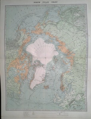
$10.04 Shipping Condition: Unspecified Location: LONDON, United Kingdom North Polar Chart Antique colour map. 1897 Title of map: North Polar Chart' The image below shows an enlarged cross section from the centre of the ... moremap to show the level of printed detail: DATE PRINTED: 1897 IMAGE SIZE: Approx 29.5 x 22.0cm. 11.5 x 8.5 inches(Large) ARTIST/CARTOGRAPHER/ENGRAVER: W. A.K. Johnston PROVENANCE: The World Wide Atlas of Modern Geography Political and Physical" by J. Scott Keltie; Published by W. A. K. Johnston. London: 3rd Edition TYPE: Antique colour map VERSO: There are images and/or text printed on the reverse side of the picture. In some cases this may be visible on the picture itself(please check the scan prior to your purchase) or around the margin of the picture CONDITION: Good; suitable for framing. However. Please note: The image shown may have been taken from a different example of this map than that which is offered for sale. The map you will receive is in good condition but there may be minor variations in the condition from that shown in the image which may include some light spotting. Please check the scan for any blemishes prior to making your purchase. Virtually all antiquarian maps and prints are subject to some normal aging due to use and time which is not obtrusive unless otherwise stated. I offer a no questions asked return policy- see below. AUTHENTICITY: This is an authentic historic print. Published at the date stated above. I do not offer reproductions. It is not a modern copy. The term'original' when applied to a print means that it was printed at the first or original date of publication; it does not imply that the item is unique. Print' means any image created by applying an inked block to paper or card under pressure by any method including wood engraving, steel engraving, copperplate, wood cut and lithography. REMARKS: FRANCE: Gravures et Cartes anciennes. DEUTSCHLAND: Alte Lankarten und Stadt ansichten. ITALIA: Stampe e Mappe antiche. ESPAÑA: Mapas antiquos y impresiones antiguas. E and OE. Force Majeure. English law shall apply. R

Buy It Now
$10.04 Shipping Condition: Unspecified Location: LONDON, United Kingdom North Polar Chart Colour antique map. 1899 Title of map: North Polar Chart' The image below shows an enlarged cross section from the centre of the ... moremap to show the level of printed detail: DATE PRINTED: 1899 IMAGE SIZE: Approx 27.0 x 21.5cm. 10.5 x 8.5 inches(Medium) ARTIST/CARTOGRAPHER/ENGRAVER: W& AK Johnston PROVENANCE: The Worldwide Atlas of Modern Geography Political and Physical" With an introduction by J. Scott Keltie, L.L.D. etc. Published by W. A.K. Johnston, Edinburgh and London. 4th Edition TYPE: Colour antique map VERSO: There is another map printed on the reverse side CONDITION: Good; suitable for framing. However. Please note: The image shown may have been taken from a different example of this map than that which is offered for sale. The map you will receive is in good condition but there may be minor variations in the condition from that shown in the image which may include some light spotting. Please check the scan for any blemishes prior to making your purchase. Virtually all antiquarian maps and prints are subject to some normal aging due to use and time which is not obtrusive unless otherwise stated. I offer a no questions asked return policy- see below. AUTHENTICITY: This is an authentic historic print. Published at the date stated above. I do not offer reproductions. It is not a modern copy. The term'original' when applied to a print means that it was printed at the first or original date of publication; it does not imply that the item is unique. Print' means any image created by applying an inked block to paper or card under pressure by any method including wood engraving, steel engraving, copperplate, wood cut and lithography. REMARKS: FRANCE: Gravures et Cartes anciennes. DEUTSCHLAND: Alte Lankarten und Stadt ansichten. ITALIA: Stampe& Mappe antiche. ESPAÑA: Mapas antiquos y impresiones antiguas. E and OE. Force Majeure. English law shall apply. RETURNS POLICY: I offer a no questions returns policy. All I ask is that you pay return shipping and mail back t
Buy It Now
$4.95 Shipping Location: Dover, United States Issued 1878, Gotha by Justus Perthes for Stieler. Map by Stieler and Berghaus. Engraved by Carl Poppey. Small inset map depicts Erebus & Terror Bay in ... moreNorth Devon, Canada. Very detailed 19th century engraved map with original hand color.
Buy It Now
$6.95 Shipping Location: Dover, United States (World Australia Torrens Hook shape Polar). Shows the fictitious hook shape to Lake Torrens., p. 110; 2.5.1.13. Issued 1859, Gotha Germany by Perthes ... morefor Ad. Scarce mid-19th century antique map. Engraved with original outline hand color.
Buy It Now
$18.76 Shipping Location: YORK, United Kingdom Beautiful ANTIQUE MAP on quality paper very good condition and rescued from a disbound. KEITH JOHNSTON'S ROYAL ATLAS 1880. THIS MAP IS AN ORIGINAL- ... moreOVER 135 YEARS OLD This FOLD-OUT map measures approximately. 23 inches by 19 inches(585mm x 483mm) FANTASTIC DETAIL ~ CONSIDERED SUPERIOR TO ALL OTHER UK ATLAS MAPS FROM THE PERIOD. sUPERB HAND COLOURED DETAILS. It is difficult to photograph these large maps and show the level of detail and superb hand coloured detailing. Please view close up to see the quality of this map. A superb map in very good condition MINOR HANDLING/AGE MARKS AT EXTREMITIES. Please message with any questions regarding this item. BEST OFFERS PLEASE FOR A QUICK SALE AT A FAIR PRICE If you like the item. But do not like the price, then make a realistic offer to us using the MAKE OFFER BUTTON. Powered by
Buy It Now
$28.33 Shipping Location: HULL, United Kingdom This was taken from a 1939 International Atlas publication titled “ Serial Map Service Atlas. This is in complete condition. It was taken from a 1939 ... moreAtlas.
Buy It Now
Free Shipping Location: Canyon Country, United States Visually accurate Robinson Projection. Get complete coverage of the World with the Advanced Political 3-Wall Map Combo. Four different symbols and four ... moredifferent type sizes show four different sizes of cities.
Buy It Now
$5.00 Shipping Location: Canada DATE OF ISSUE: 1908.
Buy It Now
$21.35 Shipping Location: Skokie, United States Shows Texas as both part of and separate from the United States, with a faint but uncolored border – which none of the other states and territories have. ... moreAntarctica drawn in only sketchily. The last official sighting was 1852, after which they were ascribed to myth.
Buy It Now
$6.95 Shipping Location: Dover, United States Issued 1881, Philadelphia by S.A. Mitchell. Fine 19th century engraved (lithographed) map, with original hand color.
Buy It Now
$5.00 Shipping Location: Galena, United States The World in Hemispheres. With Other Projections &c. &c. Title: The World in Hemispheres. Sharp floral border, nice original colors. Publication: New ... moreYork: S. Augustus Mitchell, Jr., 1860. Author: (WORLD MAP).
Buy It Now
$18.82 Shipping Location: Portugal NORTH POLAR CHART PUBLISHED BY W. A.K. JOHNSTON. 1912. An attractive map of The North Pole engraved and published by W. A. K. Johnston to accompany their"Handy ... moreRoyal Atlas" Published Edinburgh and London 1912. Measures 430 x 330 mm. Very good condition. Centrefold as issued. Attractive original colour. For further information please feel free to contact us. A guaranteed genuine antique map. SEE MORE GENUINE ANTIQUE MAPS AND PRINTS IN MY SHOP ON EBAY.CO.UK
Buy It Now
$46.14 Shipping Location: HULL, United Kingdom This is taken from the HARMSWORTH ATLAS from circa 1904. Antique c1904 colour map.
Buy It Now
$18.81 Shipping Location: YORK, United Kingdom This antique map is one of a series produced for: Bacons Popular Atlas of the British Isles The Commercial and Library Atlas of the World Publisher: G.W. ... moreBacon & Co. Ltd, London Publication Date: 1908 This listing is for the single map shown Approximate size of single page sheet 13 inches x 10 inches ****CONDITION**** PLEASE VIEW IMAGES TO SEE ANY HANDLING/AGE MARKS /REPAIRS/DAMAGE/EXTENT OF MARGINS etc  Please message with any questions regarding this item 1908.
Buy It Now
$8.85 Shipping Location: Providence, United States Item: Area and Population of Foreign Countries, Compared with the United States, 1890. Depicts: This chart in red yellow and blue shows different countries ... moreas different size circles, comparing their area and population.
Buy It Now
$18.76 Shipping Location: YORK, United Kingdom An antique map on quality paper printed in 1919 for The Victory Atlas of The World This is a particularly large format map 25 inches by 19 1/2 inches ... more(635mm x 500mm) Begun immediately after the end of WWI and takes into accout all the changes that resulted from the global conflict. Because of its large size, it has many place names not normally on such maps. ****CONDITION**** PLEASE VIEW IMAGES TO SEE ANY HANDLING/AGE MARKS /REPAIRS/DAMAGE/EXTENT OF MARGINS etc Please message with any questions regarding this item BEST OFFERS PLEASE FOR A QUICK SALE AT A FAIR PRICE If you like the item, but do not like the price, then make a realistic offer to us using the MAKE OFFER BUTTON Powered by eBay Turbo Lister.
Buy It Now
$6.90 Shipping Location: Frankfort, United States VTG 1897 DOUBLE SIDED 21.3" x 14.5 MAP.PLASTIC TAPE WAS USED TO CONNECT TO SIDES OF MAP.CHECK PHOTOS
Buy It Now
$11.95 Shipping Location: Swampscott, United States Very good condition. light wear and foxing along the edges very clean within the borders of the map. See the photos as the map in the photos is the map ... morethat you will receive.
Buy It Now
$18.95 Shipping Location: YORK, United Kingdom This antique map is one of a series produced for: BACON'S NEW GENERAL ATLAS of the WORLD Publisher: Bacon's Geographical Establishment Publication Date: ... more1900 This listing is for the single map shown Approximate size of sheet 20 inches x 14 inches ****CONDITION**** PLEASE VIEW IMAGES TO SEE ANY HANDLING/AGE MARKS /REPAIRS/DAMAGE/EXTENT OF MARGINS etc Please message with any questions regarding this item.
Buy It Now
$18.81 Shipping Location: YORK, United Kingdom A beautiful antique map on fine quality paper VERY GOOD condition and rescued from a disbound atlas: BACON'S ATLAS of the WORLD 1912 (commercial and library) ... moreMap produced & printed by: Bacon's Geographical Establishment THIS ATTRACTIVE MAP IS AN ORIGINAL OVER 100 YEARS OLD AND NOT A REPRODUCTION This SINGLE PAGE map measures approximately 13 inches by 9 1/2 inches Printed on fine quality paper Free from any text on the reverse A superb map in very good condition ~ Minor handling/age related marks at the extremities ~ Please email with any questions regarding this item (Bacon's commercial and library atlas 1912) BEST OFFERS PLEASE FOR A QUICK SALE AT A FAIR PRICE If you like the item, but do not like the price, then make a realistic offer to us using the Powered by eBay Turbo L.
Buy It Now
$10.04 Shipping Condition: Unspecified Location: LONDON, United Kingdom 'North Polar regions'. Title of map:'North Polar regions'. Antique atlas map, 1922. DATE PRINTED: 1922. AUTHENTICITY: This is an authentic historic print, ... morepublished at the date stated above. It is not a modern copy.
Buy It Now
$18.95 Shipping Location: YORK, United Kingdom AN ORIGINAL ANTIQUE MAP OVER 100 YEARS OLD This is from a collection of maps produced for BACON'S NEW GENERAL ATLAS of the WORLD 1910 THIS LISTING IS ... moreFOR THE SINGLE MAP SHOWN This single page map measures approximately 10 inches by 13 1/2 inches ****CONDITION VERY GOOD**** PLEASE VIEW IMAGES TO SEE ANY HANDLING/AGE MARKS /REPAIRS/DAMAGE/EXTENT OF MARGINS/TRIMMING etc Please message with any questions regarding this item.
Buy It Now
$31.37 Shipping Location: HASTINGS, United Kingdom In contrast, the area to the north of Russia etc. had been explored in more detail. "A Map of the Countries Thirty Degrees Round the North Pole.". Published ... moreMarch 1st 1799 by GG & I Robinson Paternoster Row.".
Buy It Now
$10.04 Shipping Condition: Unspecified Location: LONDON, United Kingdom 'North Polar Regions; South Polar Regions'. Title of map:'North Polar Regions; South Polar Regions '. Antique colour map, 1898. DATE PRINTED: 1898. The ... moreimage below shows an enlarged cross section from the centre of the map to show the level of printed detail.
Buy It Now
$18.95 Shipping Location: YORK, United Kingdom Beautiful ANTIQUE MAP on quality paper in very good condition KEITH JOHNSTON'S HANDY ROYAL ATLAS 1910 THIS MAP IS AN ORIGINAL - OVER 105 YEARS OLD PRINTED ... moreON THICK PAPER WITH VIBRANT OUTLINE COLOUR "The Handy Royal Atlas Of Modern Geography Exhibiting The Present Condition Of Geographical Discovery And Research In The Several Countries, Empires And States Of The World by Keith Alexander Johnston." map measures approximately 18 1/2 inches by 14 1/2 inches PLEASE VIEW IMAGE TO SEE HANDLING & AGE RELATED MARKS The map is free from any text or image on the reverse A superb map in very good condition Please message with any questions regarding this item QUICK SALE AT A FAIR PRICE If you like the item, but do not like the price, then make a realistic offer to us using the Powered b.
Buy It Now
$4.95 Shipping Location: Dover, United States Issued c. 1874, Leipzig by A. Brockhaus. Map by H. Lange. Planigloben in Homalographischer Projection. Late 19th century antique color lithographed map. ... moreInset depicts the north polar region. Original center fold as issued.
Buy It Now
$18.95 Shipping Location: YORK, United Kingdom Beautiful old map on quality paper printed in 1921 for The Times Atlas THIS MAP IS AN ORIGINAL - OVER 95 YEARS OLD Â This large format frameable map measures ... moreapproximately 22 1/2 inches by 17 1/2 inches (570mm x 445mm) ****CONDITION**** PLEASE VIEW IMAGES TO SEE ANY HANDLING/AGE MARKS /REPAIRS/DAMAGE/EXTENT OF MARGINS etc Please message with any questions regarding this item BEST OFFERS PLEASE FOR A QUICK SALE AT A FAIR PRICE If you like the item, but do not like the price, then make a realistic offer to us using the MAKE OFFER BUTTON Powered by eBay Turbo Lister.
Buy It Now
$14.50 Shipping Location: Albuquerque, United States 1887 William Bradley. from Bradley's Atlas.
Buy It Now
$18.96 Shipping Location: YORK, United Kingdom Beautiful ANTIQUE MAP on quality paper EXCELLENT condition and rescued from a disbound KEITH JOHNSTON'S HANDY ROYAL ATLAS 1896 THIS MAP IS AN ORIGINAL- ... moreOVER 115 YEARS OLD AND NOT A REPRODUCTION THIS MAP WAS PRODUCED IN 1896 PRINTED ON THICK PAPER WITH VIBRANT OUTLINE COLOUR"The Handy Royal Atlas Of Modern Geography Exhibiting The Present Condition Of Geographical Discovery And Research In The Several Countries. Empires And States Of The World by Keith Alexander Johnston. This DOUBLE PAGE FOLD-OUT map measures approximately 18 1/2 inches by 14 1/2 inches(470mm x 370mm) PLEASE VIEW IMAGE TO SEE HANDLING& AGE RELATED MARKS Printed on quality paper The map is free from any text or image on the reverse A superb map in excellent condition Please message with any questions regarding this item(Handy Royal Atlas 1896) BEST OFFERS PLEASE FOR A QUICK SALE AT A FAIR PRICE If you like the item. But do not like the price, then make a realistic offer to us using the MAKE OFFER BUTTON
Buy It Now
$18.95 Shipping Location: YORK, United Kingdom The map measures approximately 20 inches x 16 inches 1895 ANTIQUE MAP over 125 years old. This map is from a series produced for the Times Atlas: Published ... more1895 THIS LISTING IS FOR THE SINGLE MAP SHOWN ****CONDITION**** PLEASE VIEW IMAGES TO SEE ANY HANDLING/AGE MARKS /REPAIRS/ DAMAGE/EXTENT OF MARGINS etc Please message with any questions regarding this item .
Buy It Now
$18.95 Shipping Location: YORK, United Kingdom A beautiful VICTORIAN map on fine quality paper rescued from a disbound book atlas BACON'S NEW GENERAL ATLAS of the WORLD 1908 This SINGLE page print ... moremeasures approximately 9 1/2 inches by 13 inches (241mm x 335mm) Condition ~ EXCELLENT Please view image to see any age/handling marks ~ if in any doubt please message for a condition report on this specific print There will be unrelated text on the reverse of the print BEST OFFERS PLEASE FOR A QUICK SALE AT A FAIR PRICE If you like the item, but do not like the price, then make a realistic offer to us using the MAKE OFFER BUTTON Powered by eBay Turbo Lister.
Buy It Now
$18.95 Shipping Location: YORK, United Kingdom AN ORIGINAL MAP OVER 95 YEARS OLD This map is from a series of maps produced for The Times Atlas Published in 1921 This FOLD-OUT map measures approximately ... more22 1/2 inches by 17 1/2 inches (570mm x 445mm) THIS LISTING IS FOR THE SINGLE MAP SHOWN ****CONDITION**** PLEASE VIEW IMAGES TO SEE ANY HANDLING/AGE MARKS /REPAIRS/DAMAGE/EXTENT OF MARGINS etc Please message with any questions regarding this item BEST OFFERS PLEASE FOR A QUICK SALE AT A FAIR PRICE If you like the item, but do not like the price, then make a realistic offer to us using the MAKE OFFER BUTTON 1921.

Buy It Now
$10.04 Shipping Condition: Unspecified Location: LONDON, United Kingdom North Polar Regions; Inset map of North America; Kane Basin Vintage colour map. 1920 Title of map: North Polar Regions; Inset map of North America; Kane ... moreBasin' The image below shows an enlarged cross section from the centre of the map to show the level of printed detail: DATE PRINTED: 1920 IMAGE SIZE: Approx 33.0 x 22.0cm. 13 x 8.75 inches(Large) ARTIST/CARTOGRAPHER/ENGRAVER: Unsigned PROVENANCE: Harmsworth's new Atlas" Please note that virtually all antique and vintage maps and prints have been extracted from books. Atlases or newspapers. TYPE: Vintage colour map VERSO: There are images and/or text printed on the reverse side of the picture. In some cases this may be visible on the picture itself(please check the scan prior to your purchase) or around the margin of the picture CONDITION: Good; suitable for framing. Please check the scan for any blemishes prior to making your purchase. Virtually all antiquarian maps and prints are subject to some normal aging due to use and time which is not obtrusive unless otherwise stated. I offer a no questions asked return policy- see below. AUTHENTICITY: This is an authentic historic print. Published at the date stated above. I do not offer reproductions. It is not a modern copy. The term'original' when applied to a print means that it was printed at the first or original date of publication; it does not imply that the item is unique. Print' means any image created by applying an inked block to paper or card under pressure by any method including wood engraving, steel engraving, copperplate, wood cut and lithography. REMARKS: FRANCE: Gravures et Cartes anciennes. DEUTSCHLAND: Alte Lankarten und Stadt ansichten. ITALIA: Stampe& Mappe antiche. ESPAÑA: Mapas antiquos y impresiones antiguas. E and OE. Force Majeure. English law shall apply. RETURNS POLICY: I offer a no questions returns policy. All I ask is that you pay return shipping and mail back to me in original condition. Suitably packed& insured, within 14 days of receipt.
Buy It Now
$10.03 Shipping Location: GLASGOW, United Kingdom Provenance: Taken From the Harmsworth New Atlas. We do not deal in facsimiles or reproductions of any kind. We grade all prints individually into four ... morelevels - Excellent, Very Good, Good, and Fair.
Buy It Now
$18.95 Shipping Location: YORK, United Kingdom 1891 LARGE VICTORIAN ANTIQUE MAP OVER 125 YEARS OLD This map is from a series produced for JOHNSTON'S ROYAL ATLAS The Royal Atlas of Modern Geography. ... moreExhibiting, in a series of entirely original and authentic maps, the present condition of Geographical Discovery and Research in the several countries, empires, and states of the world.
Buy It Now
$18.95 Shipping Location: YORK, United Kingdom 1922 ANTIQUE MAP Approximately 100 years old. This map is from a series produced for the GERMAN LANGUAGE atlas: Andrees Allgemeiner Handatlas. Published ... moreLeipzig 1922 THIS LISTING IS FOR THE SINGLE MAP SHOWN The FOLD OUT map measures approximately 22 1/2 inches x 17 inches ****CONDITION**** PLEASE VIEW IMAGES TO SEE ANY HANDLING/AGE MARKS /REPAIRS/ DAMAGE/EXTENT OF MARGINS etc Please message with any questions regarding this item .
Buy It Now
$6.95 Shipping Location: Dover, United States Decorative mid-19th century engraved folio sheet map, with original hand color. Issued c. 1867-72, Philadelphia by S.A. Mitchell.
Buy It Now
$14.99 Shipping Location: Ivanhoe, Australia When he was 28 in 1850 he was elected under-Secretary. Queen Victoria, at the suggestion of Robert Bunsen, appointed him physical geographer-royal. He ... moreadvised on preparations for expeditions to Africa and to the Arctic, including the search expeditions for Sir John Franklins missing Northwest Passage Expedition.
|