|
|
Order by: Available to: This site contains affiliate links for which I may be compensated
|
Buy It Now
$18.00 Shipping Location: Alburtis, United States 1955 London TIMES ATLAS OF THE WORLD Vol. III Northern Europe - great condition for its year. Some wear on the outside. No mold, no stains, smells like ... moreold paper but clean.
Buy It Now
$6.95 Shipping Location: Dover, United States Various pie charts add to the detail.
Buy It Now
$6.95 Shipping Location: Dover, United States Cape of Good Hope, Natal &c. Issued c. 1856-72, London by Edward Weller for the Weekly Dispatch Atlas. Mid 19th century lithographed map in two sheets ... more(as issued) with original outline hand color.
Buy It Now
$28.11 Shipping Location: HASLEMERE, United Kingdom Murchison was born at Tarradale House, Muir of Ord, Ross-shire, the son of Kenneth Murchison. His wealthy father died in 1796, when Roderick was 4 years ... moreold, and he was sent to Durham School 3 years later, and then the military college at Great Marlow to be trained for the army.
$25.00 Shipping Location: Perugia, Italy At 14, Kitchin apprenticed under Emanuel Bowen, under whom he mastered the art of engraving. From 1858 or so Kitchin was the engraver to the Duke of York, ... moreand from about 1773 acquired the title, 'Royal Hydrographer to King George III.'.
Buy It Now
Free Shipping Location: Barrington, United States
Buy It Now
Free Shipping Location: Barrington, United States 96 PLATES WITH INDEX.
$5.95 Shipping Location: Hayward, United States The map is in great shape and has been well-preserved over the years, making it a valuable addition to any collection. The bottom right edge of the map ... moreshows a little roughness, otherwise the map is in Excellent condition for it's age.
$31.99 Shipping Location: LIVERPOOL, United Kingdom New Chart of the British Isles. In colour. On cloth 120 x 97 cm. Richardson Publishers Ltd, 196 Deansgate, Manchester. The chart is produced in two sections. ... moreFolds down to 33 x 21 cm. Encased in green boards with gilt titling.
$25.00 Shipping Location: Perugia, Italy Striking and highly detailed interesting 1809 Edward Daniel Clarke's original copper engraved. Date: 1809 ( dated ). Engraved by Neele, and published ... moreby Cadell & Davies. He was also presented to the college living of Harlton, near Cambridge, in 1805.
Buy It Now
$4.95 Shipping Location: Willow Grove, United States (different orientation).
$7.09 Shipping Location: Monticello, United States Dark blue cloth over boards, blind stamped front title. Published in 1972. Get images that.
$15.00 Shipping Location: Perugia, Italy Striking and highly detailed unusual 1801 John Cary's copper engraved colored. map of Turkey in Asia. Prepared in 1801 by John Cary for issue in his magnificent ... more1808 New Universal Atlas. By J. Cary 1801.
Buy It Now
$13.80 Shipping Location: MANCHESTER, United Kingdom This original antiquemap is from The Weekly Dispatch published in London in 1863. The mapmakers included Edward Weller, John Dower, R.R. Davies and J.W. ... moreLowry. This interesting map is an original antique which is over 160years old.
Buy It Now
$11.85 Shipping Location: Dover, United States The Gentleman's and London Magazine for (October) November, 1758. 1758, by Ridge. A Plan of Milford Haven. Dublin, John Exshaw. Tooley's Dictionary of ... moreMapmakers, v. 4, p. 44 (noting Ridge was Irish).
$25.00 Shipping Location: Perugia, Italy Striking and highly detailed interesting 1810 Edward Daniel Clarke's original copper engraved map showing the Harbor of Sevastopol, Russia, with his surrounding ... morelandscape. Soundings and depths are noted.
$16.29 Shipping Location: HAYLING ISLAND, United Kingdom London For Free. Map: London For Free Pocket-Sized Guide. Feature: Folded brochure with information about landmarks, museums, galleries, and cultural ... moreevents; includes a map of the London Underground.
Buy It Now
$20.00 Shipping Location: North Tonawanda, United States This copy is the 1st 1776 edition, with the Quebec map, without the Lake Champlain map, as issued. ; probably indicates that this was slightly before ... morethe NMM 361, as the 1775 title page is identical to this one (although we have not seen it yet-relying on P1165), except for the date.
Buy It Now
$56.46 Shipping Location: REDHILL, United Kingdom Hand coloured. His output was large and varied.
Buy It Now
$30.57 Shipping Location: Savannah, United States An antique map of the English county of Cumberland(part of modern Cumbria) by John Gibson. C1770. This miniature map has been hand coloured, possibly ... moreat or near the time of publication. It is in excellent condition and the engraved area measures approximately 2½ by 4½ inches Gibson was a prolific engraver who worked for several publishers in the mid-18th century. His own New and Accurate Maps of the Counties of England and Wales was first published in 1759. With later editions in 1770 and 1779. Please see our other listings for more antique maps and engravings. We have been selling antique maps and prints for over 25 years through our shop and cumbriamaps website so bid with confidence.

Buy It Now
$10.03 Shipping Location: GLASGOW, United Kingdom EURASIA Lambert Azimuthal Equal-Area Projection-Vintage Map 1956 by Bartholomew Print Description: EURASIA Lambert Azimuthal Equal-Area Projection-Vintage ... moreMap 1956 by Bartholomew Size: The Size of the print/map not including margins is approximately 22x17 inches. Cartographer: Map by John Bartholomew. Provenance: Taken From The Times Atlas of the World Mid-Century Edition. Published by The Times Publishing Company Ltd. Printing House Square, London 1956. Authenticity: This is a guaranteed genuine antique print. We do not deal in facsimiles or reproductions of any kind. Condition: Excellent; Suitable for framing. We grade all prints individually into four levels- Excellent. Very Good, Good, and Fair. Generally prints in excellent condition are free from foxing, rips,tears or folds. Very Good prints may have some minor foxing or spotting, however this will mainly be confined to the margins. Good and fair may have more general foxing. We try to represent all the images to the best of our ability, and we ask you to check the above scans before purchasing Payment: PayPal is our only accepted method of payment. We accept PayPal payments from buyers all over the world. PayPal is the safest. Easiest and quickest way to make online purchases. If you are purchasing multiple items, please add all the items to your shopping basket before proceeding to the checkout. If you do not already have a PayPal account, simply click on the'Buy It Now' button and follow the eBay checkout instructions. You will then be able to enter your card details in order to pay via PayPal even if you do not already have a PayPal account. Paying via PayPal also ensures that your purchase is fully protected and guaranteed. Returns Policy: If for any reason you are not satisfied with your order we will gladly accept a return for refund or credit. If you wish to return goods you MUST inform us within 14 days of receipt of your order. Please do not return goods without prior consent. All returns must be received in perfect re-saleable condition i
Buy It Now
$6.00 Shipping Location: Los Angeles, United States 2 Britannia. It is a work ofchorography : a study that relates landscape, geography, antiquarianism, and history. Rather than write a history, Camden ... morewanted to describe in detail the Great Britain of the present, and to show how the traces of the past could be discerned in the existing landscape.
Buy It Now
$8.79 Shipping Location: Greenacres, United States Large-format, hardcover world atlas and gazetteer, with 268 pages. Condition: This atlas is complete, intact, and in excellent condition. The cover boards ... moreare sound, with strong corners and no edge wear.
Buy It Now
$25.00 Shipping Location: Belvedere Tiburon, United States Th century. The four angling players are England, France, Tsarist Russia, and the Ottoman Empire. They have been poignantly represented on the map, with ... morethe national characters of each holding physical lines, representing the direction in which their interests as a nation lie.
Buy It Now
Free Shipping Location: Owego, United States Total size is 15 1/2 x 20 1/4 inches to edges of page. Vertical fold across center. Otherwise overall nice condition. Check our listings for more vintage ... moremaps.
Buy It Now
$5.65 Shipping Location: HASTINGS, United Kingdom Dated in pencil at the side 1826. A map of England and Wales, presumably taken from a book, with three folds.

Buy It Now
$25.00 Shipping Location: Belvedere Tiburon, United States This is an exquisite full-color Reproduction printed on heavyweight(7.0 MIL) Glossy Photo Paper. These maps are perfect for framing. Or a wonderful and ... moreunique gift for family members, friends or co-workers! All Information is Carefully Compiled from Actual Surveys Original Maps are often difficult to find and usually have fold lines. Identifying stamps or markings, tears, ragged edges, and assorted other natural signs of age that detract from their beauty. All of our maps have been professionally restored to depict their original beauty, while keeping all historical data intact. These maps are fabulous pieces of history full of information useful to Historians. Genealogists, Cartographers, Relic Hunters, Others. They make fascinating conversation pieces and splendid works of art for the home or office. This historic map captures history through a unique perspective. Event maps are authentic records of battles fought throughout the history of American wars. Dating back to the French& Indian War and recorded through the eyes of the noble military men themselves. They would make an excellent addition to any history buff's collection. Map Size: 23.00 x 27.56 Site Specifics To This Map Are: Arundel. Petersburg, Albany, Boston, Plymouth, Woodstock, Danbury, Harlem, Newcastle, Canterbury, and several other cities and towns throughout eastern North America. The following towns are featured: Province of New Hampshire. Part of New York, Colony of Connecticut, Province of Massachusets, Eastern Part of Massachusets, Rhode Island, Long Island, Hudson River, Connecticut River, Kusumpe Pond, Sunape Pond, and Lake George. Also Features a close-up insert of the town of Boston. This Map is Situated in: Eastern United States SKU: REWA0107 and Powered By: `0d.RcmdId ViewItemDescV4,RlogId p4%60bo7%60jtb9%3Fuk.rp*fc%3E%3E%600d-13deb7fd3e6-0xf7-
Buy It Now
$13.80 Shipping Location: MANCHESTER, United Kingdom This interesting map is an original antique which is over 125 years old.
Buy It Now
$23.02 Shipping Location: STAFFORD, United Kingdom It is not a modern copy. The map has been carefully extracted from a no longer usable and dis-bound Devotional Bible. Overall in very good condition for ... morea map that is over 160 years old. There is no print on the reverse side.
Buy It Now
$13.80 Shipping Location: MANCHESTER, United Kingdom This original antiquemap is from The Weekly Dispatch published in London in 186 3. The mapmakers included Edward Weller, John Dower, R.R. Davies and J.W. ... moreLowry. This interesting map is an original antique which is over 160years old.
Buy It Now
$13.80 Shipping Location: MANCHESTER, United Kingdom This large folding map is from The Weekly Dispatch published in London in 1861.

Buy It Now
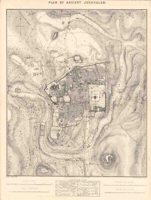
$25.00 Shipping Location: Belvedere Tiburon, United States Ancient and Modern Jerusalem City Plan Palestine Israel 1895 Antique Color Map. Fine antique color lithographed map issued in Leipzig(Germany) by F. A. ... moreBrockhaus in 1895. It measures 9.4" x 5.9(24 x 15 cm. This printed map is more than 100 years old and is in good to very good condition. It would look great matted and framed. We do not sell modern reprints. All of our items are original antique pieces and it is important to keep in mind that many of them can have some imperfections. Discoloration and minimal spots, but this is due to age. Double page or centerfold means that it has a crease in the middle from where it originaly was folded and attached to a book. Please look at the pictures carefully, read the description of each item and examine the pictures with zoom. Payment We happily accept Paypal. Bank transfers are also accepted. Payment is appreciated within 7 days of invoicing. Shipping All of our prints and maps will be shipped from Bonn(Germany) We ensure that all items sold are packed securely and professionally. Once payment has been received we do our best to make sure all orders are shipped within two businnes days. Flat worldwide shipping rate of $8. We combine shipping costs. Multiple item buyers are welcome. No matter how many prints/ maps you buy you'll only pay $8 on shipping costs. We offer free shipping costs for orders over $100. Returns Returns are accepted within 14 days but we do request that you contact us before returning any item. inkfrog terapeak. I000000. InkFrog Analytics.
Buy It Now
$30.00 Shipping Location: Paris VI, France Unusual antique engraved map of Hong Kong, dated 1845. Edition: London, by Henry Colburn, 1845, 19th Century. Title of the map "Map of Hong-Kong".
Buy It Now
$25.00 Shipping Location: Belvedere Tiburon, United States Click Here. Double your traffic. Get Vendio Gallery- Now FREE! Plan Diagram Solomons Herods Temple Ancient Jerusalem 1853 Hand Colored Engrav SOLOMONS ... moreTEMPLE Original 1853 engraving" Plan or Solomons Temple. hand colored. This 158 year old engraving features Solomons Temple showing court of the Woman, Court of the People, and Court of the Priests. Also shown is the plan of Herods Temple. Minor foxing otherwise very good condition, overall size 10" x 6" Purchase with confidence. We have been in the antique print, map, and document business since 1976 and guarantee our items as advertised. See additional photos below! To See More Photos/Scenes Pay via PayPal. US Funds only. We ship 7 business days(excludes Saturday and Sunday) from receipt of payment. Shipping if buying multiple items within 7 day period. We will ship in one package for one item's shipping fee( as long as size permits) International shipping please contact us for a quote prior to bidding. Thank you for your business. Powered by We ship in 5 business days form receipt of payment. If you need it faster please advise. We can usually meet most dead lines.
Buy It Now
$5.00 Shipping Location: Los Angeles, United States 2 Britannia. It is a work ofchorography : a study that relates landscape, geography, antiquarianism, and history. Rather than write a history, Camden ... morewanted to describe in detail the Great Britain of the present, and to show how the traces of the past could be discerned in the existing landscape.
Buy It Now
$20.55 Shipping Location: BATH, United Kingdom Isle of Wight by Thomas Moules 1842. Thomas Moules (1784-1851) was a writer on heraldry and antiques born in Marylebone in London. The map were re-issued ... moreagain in 1841, showing railways which had been constructed, in 'Barclays complete and universal English Dictionary'.
Buy It Now
$5.00 Shipping Location: Canada DATE OF ISSUE: 1922.
Buy It Now
$13.80 Shipping Location: MANCHESTER, United Kingdom This original antiquemap is from The Weekly Dispatch published in London in 186 3. The mapmakers included Edward Weller, John Dower, R.R. Davies and J.W. ... moreLowry. This interesting map is an original antique which is over 160years old.
Buy It Now
$13.80 Shipping Location: MANCHESTER, United Kingdom This original antiquemap is from The Weekly Dispatch published in London in 1863. The mapmakers included Edward Weller, John Dower, R.R. Davies and J.W. ... moreLowry. This interesting map is an original antique which is over 160years old.
Buy It Now
$18.82 Shipping Location: HASTINGS, United Kingdom This is a magnificent, early Geological Map, handcoloured, mounted on linen. The map extends into Scotland above Edinburgh, and has two sections. One, ... moreat the top "from St George's Channel to the German Ocean", and the other "Geological and Mineralogical Section from Lands End to the German Ocean" at the bottom.
Buy It Now
$5.00 Shipping Location: Canada DATE OF ISSUE: 1959.
6d 4h 59m 28s 0 bids
$74.95 Now
$5.45 Shipping Location: Sioux Falls, United States Vintage 1944 Philips Great Britain Foldout Road Map. A WW2 Era Production which is really unique given the destruction that was unfolding in Europe at ... morethe time. Very good condition with very little wear on the fold seams. Measures 22” x 35” when opened. Most of these come from overseas with high shipping costs. Not here…….take advantage of it!
Buy It Now
$13.80 Shipping Location: MANCHESTER, United Kingdom This original antiquemap is from The Weekly Dispatch published in London in 186 3. The mapmakers included Edward Weller, John Dower, R.R. Davies and J.W. ... moreLowry. This interesting map is an original antique which is over 160years old.
Buy It Now
$56.46 Shipping Location: REDHILL, United Kingdom Hand coloured. His output was large and varied.
$44.99 Shipping Location: Ivanhoe, Australia Date: - 1626 (1676). This map is both beautiful and important. In the high Arctic, near Iceland and Greenland, the supposed islands of Frisland and Brasil ... moreare noted. Frisland is little more than a double mapping of Iceland.
Buy It Now
$6.00 Shipping Location: Richmond, United States This map is probably from the 1753 edition of 'Britannia'. Fold as issued. Blank on the reverse. Map area is in good condition for age, engravings are ... moreclear. Hand colouring. Copper engraved map on hand laid paper.
$44.99 Shipping Location: Ivanhoe, Australia Wyld's Military Map Of The United States, The Northern States, And The Southern Confederate States: With The Forts, Harbours, Arsenals And Military Positions. ... moreWyld was particularly masterful at capturing political events throughout the world as they happened and leveraging his impressive publishing operation to quickly produce and distribute pertinent to the invested public.
Buy It Now
$8.78 Shipping Location: BATH, United Kingdom This map is a miniature version printed in Thomas Cox's work in 1720. Published in Thomas Cox's 'Magna Britannia et Hibernia, Antiqua & Nova' 1720 edition. ... moreFolds as issued. Blank on the reverse.
Buy It Now
$5.00 Shipping Location: Canada DATE OF ISSUE: 1922.
Buy It Now
$5.00 Shipping Location: Los Angeles, United States 2 Britannia. It is a work ofchorography : a study that relates landscape, geography, antiquarianism, and history. Rather than write a history, Camden ... morewanted to describe in detail the Great Britain of the present, and to show how the traces of the past could be discerned in the existing landscape.
Buy It Now
$6.75 Shipping Location: Sierra Vista, United States ORIGINAL SDUK NORTH AFRICA BARBARY 5 PAGE MAP SET TITLE NORTH AFRICA BARBARY TRIPOLI EGYPT ALGIER TUNIS TRIPOLI MAPS ARE DATED 1834. 1836, 1837 BOTTOM ... moreCENTER ISSUED AND PUBLISHED BY SOCIETY FOR THE DIFFUSION FOR USEFUL KNOWLEDGE BALDWIN AND CRADOCK LONDON THIS AUCTION IS FOR AN ORIGINAL HAND-COLORED 5 PAGE MAP OF NORTH AFRICA AND BARBARY. MAPS SHOW FROM MOROCCO AT LEFT TO EGYPT AT RIGHT. MANY TOWNSHIPS AND VILLAGES ARE SHOWN AS WELL AS SOME OF THE EARLY TRAVEL AND TRADE ROUTES. ALL MAPS MEASURE 16 X 13.5 INCHES EACH CONDITION FAIR. FOXING AND OR DISCOLORATION AND SMALL CHIPS AT BOTTOM AND SIDES AND MINOR SMUDGING
Buy It Now
$5.95 Shipping Condition: New Location: Las Vegas, United States London “Wonderground” Map. Year: 1927. This unusual and colorful map was originally commissioned by the London Underground in order to highlight the London ... moreUnderground Stations. “Vibrant and bright!
Buy It Now
$5.95 Shipping Condition: New Location: Las Vegas, United States Originally published in the "CIvitates Orbis Terrarum", this striking reproduction Map of Early London, shows the London of 1561. The location of Charing ... moreCross is mostly farmland and fields still. Historic Map of London.
Buy It Now
$8.70 Shipping Location: Vero Beach, United States The Arrowsmiths were a family of English mapmakers. He was joined in 1810 by his nephew John Arrowsmith. "Drawn under the direction of M. Arrowsmith. ... moreHall sculpt. Published for the Society for promoting Christian Knowledge, by M. Rivington, St Paul's Church Yard, London, May.".

Buy It Now
$10.04 Shipping Condition: Unspecified Location: LONDON, United Kingdom Zoological Gardens Vintage print. 1935 Title of map: Zoological Gardens' The image below shows an enlarged cross section from the centre of the map ... moreto show the level of printed detail. This map is folding hence the centrefold line may show on the image below: DATE PRINTED: 1935 IMAGE SIZE: Approx 14.0 x 19.5cm. 5.5 x 7.5 inches(Medium) Please note that this is a folding map. ARTIST/CARTOGRAPHER/ENGRAVER: Unsigned PROVENANCE: The Blue Guides London and its Environs" Edited by Findlay Muirhead& L. Russell Muirhead. Published by Ernest Benn Ltd. London: 4th Edition. Please note that virtually all antique and vintage maps and prints have been extracted from books, atlases or newspapers. TYPE: Vintage print VERSO: There is nothing printed on the reverse side. Which is plain CONDITION: Good; suitable for framing. Please check the scan for any blemishes prior to making your purchase. Virtually all antiquarian maps and prints are subject to some normal aging due to use and time which is not obtrusive unless otherwise stated. I offer a no questions asked return policy- see below. AUTHENTICITY: This is an authentic historic print. Published at the date stated above. I do not offer reproductions. It is not a modern copy. The term'original' when applied to a print means that it was printed at the first or original date of publication; it does not imply that the item is unique. Print' means any image created by applying an inked block to paper or card under pressure by any method including wood engraving, steel engraving, copperplate, wood cut and lithography. REMARKS: FRANCE: Gravures et Cartes anciennes. DEUTSCHLAND: Alte Lankarten und Stadt ansichten. ITALIA: Stampe& Mappe antiche. ESPAÑA: Mapas antiquos y impresiones antiguas. E and OE. Force Majeure. English law shall apply. RETURNS POLICY: I offer a no questions returns policy. All I ask is that you pay return shipping and mail back to me in original condition. Suitably packed& insured, within 14 days of receipt.
Buy It Now
$10.00 Shipping Location: Chicago, United States Bowles’ New One Sheet Map of Jamaica, Divided Into Its Parishes, & c. from the Actual Surveys of Sheffield and Others. This is a superb original color ... moreexample of Bowles’ highly detailed Map of Jamaica, which also includes an inset map entitled ‘A General Plan of the Port of Royal…’.
Buy It Now
$3.76 Shipping Location: BATH, United Kingdom The Arrowsmith map publishing house was founded by Aaron Arrowsmith (1750-1823) at 10 Soho Square, London in about 1790. This small map is from 'An Atlas ... moreof Ancient Geography' first published by Aaron Arrowsmith in 1829.
Buy It Now
$6.95 Shipping Location: Dover, United States Issued c. 1905, London by George Philip & Son for London Geographical Atlas. Early 20th century color lithographed map. Original center fold as issued.
Buy It Now
$6.95 Shipping Location: Dover, United States Various pie charts add to the detail. Foreign Trade of Russia by Commodities for 1913 & 1922 [insets at bottom]. Issued 1925-8, London by the London Geographical ... moreInstitute, printed by George Philip & Son.
|
|
|
|
1922 Detailed Colored Atlas Map BRITISH ISLES Vegetation & Climate London Times
1922 Detailed Colored Atlas Map Plate 15- BRITISH ISLES Vegetation& Climate Map by The London Times Shipping for additional maps only $.50 to U.S. address. There Are More Images Below Side One This is a wonderful lithographed atlas map. It measures 17-1/2 inches x 23-1/4 inches. It is folded in the middle but it is one piece of paper. It was published in 1922 by The Times Printing House Square. London, E C.4. It was prepared at the"Edinburgh Geographical Institute" under the direction of J.C. Bartholomew, Cartographer to the King. Date Published: 1922. Atlas Title: The Times Survey Atlas of the World. This is the cover page from the atlas(not included) GUARANTEED ORIGINAL- NO REPRODUCTIONS! We will send you an email eBay by the morning after the auction. Please make sure that your email address on file with eBay is correct. ... moreIf you do not find this email. Please check your spam folder. We will combine shipments when practical to save on shipping costs(please wait for an invoice before paying) Shipping and handling costs are as noted below. Shipments to countries other than the U.S. or Canada that are valued at $100 or more will incur an additional shipping and handling charge of $11.50 to cover the cost of Registered Mail. This is for your protection as well as ours. Shipments will be made within one business day of receipt of your cleared payment. We ship by U.S. Postal Service First Class or Priority Mail to U.S. and Canada addresses. Shipments to countries other than the U.S. or Canada are by U.S. Postal Service International First Class Mail. We accept Paypal. Affordable Auction Management Solutions@ inkFrog inkfrog terapeak. I000000.
|
|
|
1922 Detailed Colored Atlas Map Plate 86 Ontario & Quebec Canada - London Times
WELCOME TO RARE ATTIC TREASURES! Shipping Discounts are available when purchasing multiple items. 1922 Detailed Colored Atlas Map Plate 86- Ontario& Quebec Canada by The London Times Shipping for additional maps only $.50 to U.S. address. There Are More Images Below Side One This is a wonderful lithographed atlas map. It measures 17-1/2 inches x 23-1/4 inches. It is folded in the middle but it is one piece of paper. It was published in 1922 by The Times Printing House Square. London, E C.4. It was prepared at the"Edinburgh Geographical Institute" under the direction of J.C. Bartholomew, Cartographer to the King. Date Published: 1922. Atlas Title: The Times Survey Atlas of the World. This is the cover page from the atlas(not included) GUARANTEED ORIGINAL- NO REPRODUCTIONS! We will send you an email eBay by the morning after the ... moreauction. Please make sure that your email address on file with eBay is correct. If you do not find this email. Please check your spam folder. We will combine shipments when practical to save on shipping costs(please wait for an invoice before paying) Shipping and handling costs are as noted below. Shipments to countries other than the U.S. or Canada that are valued at $100 or more will incur an additional shipping and handling charge of $11.50 to cover the cost of Registered Mail. This is for your protection as well as ours. Shipments will be made within one business day of receipt of your cleared payment. We ship by U.S. Postal Service First Class or Priority Mail to U.S. and Canada addresses. Shipments to countries other than the U.S. or Canada are by U.S. Postal Service International First Class Mail. We accept Paypal. Affordable Auction Management Solutions@ inkFrog inkfrog terapeak. I000000.
|
|
|
1922 Detailed Colored Atlas Map BRITISH ISLES Railways & Industrial London Times
1922 Detailed Colored Atlas Map Plate 16- BRITISH ISLES Railways& Industrial Map by The London Times Shipping for additional maps only $.50 to U.S. address. There Are More Images Below Side One This is a wonderful lithographed atlas map. It measures 17-1/2 inches x 23-1/4 inches. It is folded in the middle but it is one piece of paper. It was published in 1922 by The Times Printing House Square. London, E C.4. It was prepared at the"Edinburgh Geographical Institute" under the direction of J.C. Bartholomew, Cartographer to the King. Date Published: 1922. Atlas Title: The Times Survey Atlas of the World. This is the cover page from the atlas(not included) GUARANTEED ORIGINAL- NO REPRODUCTIONS! We will send you an email eBay by the morning after the auction. Please make sure that your email address on file with eBay is correct. ... moreIf you do not find this email. Please check your spam folder. We will combine shipments when practical to save on shipping costs(please wait for an invoice before paying) Shipping and handling costs are as noted below. Shipments to countries other than the U.S. or Canada that are valued at $100 or more will incur an additional shipping and handling charge of $11.50 to cover the cost of Registered Mail. This is for your protection as well as ours. Shipments will be made within one business day of receipt of your cleared payment. We ship by U.S. Postal Service First Class or Priority Mail to U.S. and Canada addresses. Shipments to countries other than the U.S. or Canada are by U.S. Postal Service International First Class Mail. We accept Paypal. Affordable Auction Management Solutions@ inkFrog inkfrog terapeak. I000000.
|
|
|
1922 Detailed Colored Atlas Map BRITISH ISLES Bathy - Orographical London Times
1922 Detailed Colored Atlas Map Plate 14- BRITISH ISLES Bathy- Orographical Map by The London Times Shipping for additional maps only $.50 to U.S. address. There Are More Images Below Side One This is a wonderful lithographed atlas map. It measures 17-1/2 inches x 23-1/4 inches. It is folded in the middle but it is one piece of paper. It was published in 1922 by The Times Printing House Square. London, E C.4. It was prepared at the"Edinburgh Geographical Institute" under the direction of J.C. Bartholomew, Cartographer to the King. Date Published: 1922. Atlas Title: The Times Survey Atlas of the World. This is the cover page from the atlas(not included) GUARANTEED ORIGINAL- NO REPRODUCTIONS! We will send you an email eBay by the morning after the auction. Please make sure that your email address on file with eBay is correct. If you ... moredo not find this email. Please check your spam folder. We will combine shipments when practical to save on shipping costs(please wait for an invoice before paying) Shipping and handling costs are as noted below. Shipments to countries other than the U.S. or Canada that are valued at $100 or more will incur an additional shipping and handling charge of $11.50 to cover the cost of Registered Mail. This is for your protection as well as ours. Shipments will be made within one business day of receipt of your cleared payment. We ship by U.S. Postal Service First Class or Priority Mail to U.S. and Canada addresses. Shipments to countries other than the U.S. or Canada are by U.S. Postal Service International First Class Mail. We accept Paypal. Affordable Auction Management Solutions@ inkFrog inkfrog terapeak. I000000.
|
|
|
1922 Detailed Colored Atlas Map EASTERN EUROPE Political Map by The London Times
1922 Detailed Colored Atlas Map Plate 13- EASTERN EUROPE Political Map by The London Times Shipping for additional maps only $.50 to U.S. address. There Are More Images Below Side One This is a wonderful lithographed atlas map. It measures 17-1/2 inches x 23-1/4 inches. It is folded in the middle but it is one piece of paper. It was published in 1922 by The Times Printing House Square. London, E C.4. It was prepared at the"Edinburgh Geographical Institute" under the direction of J.C. Bartholomew, Cartographer to the King. Date Published: 1922. Atlas Title: The Times Survey Atlas of the World. This is the cover page from the atlas(not included) GUARANTEED ORIGINAL- NO REPRODUCTIONS! We will send you an email eBay by the morning after the auction. Please make sure that your email address on file with eBay is correct. If you do not ... morefind this email. Please check your spam folder. We will combine shipments when practical to save on shipping costs(please wait for an invoice before paying) Shipping and handling costs are as noted below. Shipments to countries other than the U.S. or Canada that are valued at $100 or more will incur an additional shipping and handling charge of $11.50 to cover the cost of Registered Mail. This is for your protection as well as ours. Shipments will be made within one business day of receipt of your cleared payment. We ship by U.S. Postal Service First Class or Priority Mail to U.S. and Canada addresses. Shipments to countries other than the U.S. or Canada are by U.S. Postal Service International First Class Mail. We accept Paypal. Affordable Auction Management Solutions@ inkFrog inkfrog terapeak. I000000.
|
|
|
1922 Detailed Colored Atlas Map WESTERN EUROPE Political Map by The London Times
1922 Detailed Colored Atlas Map Plate 12- WESTERN EUROPE Political Map by The London Times Shipping for additional maps only $.50 to U.S. address. There Are More Images Below Side One This is a wonderful lithographed atlas map. It measures 17-1/2 inches x 23-1/4 inches. It is folded in the middle but it is one piece of paper. It was published in 1922 by The Times Printing House Square. London, E C.4. It was prepared at the"Edinburgh Geographical Institute" under the direction of J.C. Bartholomew, Cartographer to the King. Date Published: 1922. Atlas Title: The Times Survey Atlas of the World. This is the cover page from the atlas(not included) GUARANTEED ORIGINAL- NO REPRODUCTIONS! We will send you an email eBay by the morning after the auction. Please make sure that your email address on file with eBay is correct. If you do not ... morefind this email. Please check your spam folder. We will combine shipments when practical to save on shipping costs(please wait for an invoice before paying) Shipping and handling costs are as noted below. Shipments to countries other than the U.S. or Canada that are valued at $100 or more will incur an additional shipping and handling charge of $11.50 to cover the cost of Registered Mail. This is for your protection as well as ours. Shipments will be made within one business day of receipt of your cleared payment. We ship by U.S. Postal Service First Class or Priority Mail to U.S. and Canada addresses. Shipments to countries other than the U.S. or Canada are by U.S. Postal Service International First Class Mail. We accept Paypal. Affordable Auction Management Solutions@ inkFrog inkfrog terapeak. I000000.
|
|
|
1922 Detailed Colored Atlas Map EUROPE Orography Vegetation Races London Times
1922 Detailed Colored Atlas Map Plate 11- EUROPE Orography. Vegetation, Races, Population Map by The London Times Shipping for additional maps only $.50 to U.S. address. There Are More Images Below Side One This is a wonderful lithographed atlas map. It measures 17-1/2 inches x 23-1/4 inches. It is folded in the middle but it is one piece of paper. It was published in 1922 by The Times Printing House Square. London, E C.4. It was prepared at the"Edinburgh Geographical Institute" under the direction of J.C. Bartholomew, Cartographer to the King. Date Published: 1922. Atlas Title: The Times Survey Atlas of the World. This is the cover page from the atlas(not included) GUARANTEED ORIGINAL- NO REPRODUCTIONS! We will send you an email eBay by the morning after the auction. Please make sure that your email address on file with eBay is ... morecorrect. If you do not find this email. Please check your spam folder. We will combine shipments when practical to save on shipping costs(please wait for an invoice before paying) Shipping and handling costs are as noted below. Shipments to countries other than the U.S. or Canada that are valued at $100 or more will incur an additional shipping and handling charge of $11.50 to cover the cost of Registered Mail. This is for your protection as well as ours. Shipments will be made within one business day of receipt of your cleared payment. We ship by U.S. Postal Service First Class or Priority Mail to U.S. and Canada addresses. Shipments to countries other than the U.S. or Canada are by U.S. Postal Service International First Class Mail. We accept Paypal. Affordable Auction Management Solutions@ inkFrog inkfrog terapeak. I000000.
|
|
|
1922 Detailed Colored Atlas Map - WORLD Climate Plate 3 by The London Times
1922 Detailed Colored Atlas Map- WORLD Climate Plate 3 by The London Times Shipping for additional maps only $.50 to U.S. address. There Are More Images Below Side One This is a wonderful lithographed atlas map. It measures 17-1/2 inches x 23-1/4 inches. It was published in 1922 by The Times Printing House Square. London, E C.4. It was prepared at the"Edinburgh Geographical Institute" under the direction of J.C. Bartholomew, Cartographer to the King. Date Published: 1922. Atlas Title: The Times Survey Atlas of the World. This is the cover page from the atlas(not included) GUARANTEED ORIGINAL- NO REPRODUCTIONS! We will send you an email eBay by the morning after the auction. Please make sure that your email address on file with eBay is correct. If you do not find this email. Please check your spam folder. We will combine shipments ... morewhen practical to save on shipping costs(please wait for an invoice before paying) Shipping and handling costs are as noted below. Shipments to countries other than the U.S. or Canada that are valued at $100 or more will incur an additional shipping and handling charge of $11.50 to cover the cost of Registered Mail. This is for your protection as well as ours. Shipments will be made within one business day of receipt of your cleared payment. We ship by U.S. Postal Service First Class or Priority Mail to U.S. and Canada addresses. Shipments to countries other than the U.S. or Canada are by U.S. Postal Service International First Class Mail. We accept Paypal. Affordable Auction Management Solutions@ inkFrog inkfrog terapeak. I000000.
|
|
 |