|
|
Order by: Available to: This site contains affiliate links for which I may be compensated
|
Buy It Now
$6.95 Shipping Location: Dover, United States Charming small mid 19th century map with original outline hand color.
Buy It Now
$13.80 Shipping Location: MANCHESTER, United Kingdom This beautiful map is from The Imperial Atlas of Modern Geography by W.G. Blackie, published by Blackie and Son, London, 1860.
Buy It Now
$6.95 Shipping Location: Dover, United States Issued c. 1850, Hildburghausen, Germany by the Bibliographic Institute. Mid 19th century antique engraved map with original outline hand color.
Buy It Now
$16.45 Shipping Location: Lakewood, United States 1964 Indian Ocean (southern part) Naval Oceanographic Survey Map. This piece is in great condition and measures 36 in by 54 in. It was published by the ... moreUnited States Naval Oceanographic Office under the authority of the Secretary of the Navy. (See photos).
Buy It Now
Free Shipping Location: Fairfield, United States Set of 4 Pilot Charts of the Indian Ocean etc., by the U.S. Navy Dept. w/envelope. Charts date Dec. 1940, August 1946, Sept. 1946 & Oct. 1946. 2' w x ... more3". All in good condition no tears or markings, just creases.
Buy It Now
$4.95 Shipping Location: Dover, United States (Map, South Africa, Indian Ocean, South Atlantic Ocean, Cape Town, Cape Colony, Orange Free State ). Late 19th century lithographed map with strong original ... morehand color. South Africa.
Buy It Now
Free Shipping Location: Sayville, United States
$25.00 Shipping Location: Perugia, Italy The chart notes the city with his buildings, harbors, soundings, depths and surrounding landscape. Date: 1884 ( undated ). Very strong and dark impression ... moreon good paper. Map old original colored. Small foxing and browning.
Buy It Now
Free Shipping Location: Sayville, United States See photo's.

Buy It Now
$10.04 Shipping Condition: Unspecified Location: LONDON, United Kingdom Indian Ocean on Mercator's Projection Vintage colour map. 1920 Title of map: Indian Ocean on Mercator's Projection' DATE PRINTED: 1920 IMAGE ... moreSIZE: Approx 32.5 x 22.0cm. 12.75 x 8.75 inches(Large) ARTIST/CARTOGRAPHER/ENGRAVER: Unsigned PROVENANCE: Harmsworth's new Atlas" Please note that virtually all antique and vintage maps and prints have been extracted from books. Atlases or newspapers. TYPE: Vintage colour map VERSO: There are images and/or text printed on the reverse side of the picture. In some cases this may be visible on the picture itself(please check the scan prior to your purchase) or around the margin of the picture CONDITION: Good; suitable for framing. However. Please note: The item offered for sale is one page of a map originally published on two adjacent pages- it lacks a full border and may have a tight margin along one edge(see image) Please check the scan for any blemishes prior to making your purchase. Virtually all antiquarian maps and prints are subject to some normal aging due to use and time which is not obtrusive unless otherwise stated. I offer a no questions asked return policy- see below. AUTHENTICITY: This is an authentic historic print. Published at the date stated above. I do not offer reproductions. It is not a modern copy. The term'original' when applied to a print means that it was printed at the first or original date of publication; it does not imply that the item is unique. Print' means any image created by applying an inked block to paper or card under pressure by any method including wood engraving, steel engraving, copperplate, wood cut and lithography. REMARKS: FRANCE: Gravures et Cartes anciennes. DEUTSCHLAND: Alte Lankarten und Stadt ansichten. ITALIA: Stampe& Mappe antiche. ESPAÑA: Mapas antiquos y impresiones antiguas. E and OE. Force Majeure. English law shall apply. RETURNS POLICY: I offer a no questions returns policy. All I ask is that you pay return shipping and mail back to me in original condition. Suitably packed& i
Buy It Now
$6.90 Shipping Location: Jasper, United States Known for being one of the oldest and most respected publishing houses in Germany, the Bibliographisches Institut specialized in authoritative reference ... moreworks. The map's condition is as shown in the pictures.
Buy It Now
$30.00 Shipping Location: Paris VI, France The map is engraved by A. Piat. The map is bordered on both sides by very finely engraved depictions of foliage, barrels, fruit, fish, and animals.
Buy It Now
$21.27 Shipping Location: SUTTON COLDFIELD, United Kingdom MAGNIFICENT LARGE HARDBACK MAP. ABOUT THIS MAP. CONDITION: Excellent condition perfectly preserved in the archives.
Buy It Now
$6.95 Shipping Location: Dover, United States Indian Ocean Distribution of Oceanic Deposits. Scarce late 19th century color lithographed map issued for the Scottish Geographical Magazine, possibly ... moreunique to that publication. Uncommon 19th century oceanography thematic map.
Buy It Now
$6.95 Shipping Location: Dover, United States Issued 1856, Edinburgh by William Blackwood and Sons. Engraved by W & A.K. Johnston. Detailed and lovely large mid 19th century color lithographed folio ... moremap with piano key border.
Buy It Now
$6.95 Shipping Location: Dover, United States (Indian Ocean, Madagascar, Amirantes, Seychelles, Socotra, Rodrigue, Chagos, Keeling Isles, Mauritius, Bourbon, Reunion, Lakadives, Maldives, Kerguelen, ... moreAndaman Isles. Engraved by J & C Walker. Islands of the Indian Ocean. ).
Buy It Now
$10.04 Shipping Condition: Unspecified Location: LONDON, United Kingdom Antique engraved atlas map with original hand colour/color, 1859. DATE PRINTED: 1859. TYPE: Antique engraved atlas map with original hand colour/color. ... moreAUTHENTICITY: This is an authentic historic print, published at the date stated above.
Buy It Now
$13.11 Shipping Location: BOURNE END, United Kingdom Produced by Benjamin Eli Smith for The Century Atlas of the World c1901. Overall Excellent Condition with Original Litho Colour. Antique Map Oklahoma ... moreand India Territory. Blank to verso. An original double page map with centrefold as issued within Atlas.
Buy It Now
$6.00 Shipping Location: Greenacres, United States Bowen, Geographer to his Majesty 1747.". Emanuel Bowen (1694-1767) achieved the unique distinction of becoming Royal Mapmaker to both King George II of ... moreGreat Britain and Louis XV of France. A large area of the northwest coast, predating Cook's explorations, is labeled "Parts Undiscovered.".
Buy It Now
$30.00 Shipping Location: Paris VI, France The map is bordered on both sides by very finely engraved depictions of foliage, barrels, fruit, fish, and animals.
Buy It Now
$6.00 Shipping Location: Los Angeles, United States This is one of the most decorative atlases ever published with each map surrounded by engraved images of local scenes, events, people and indigenous animals. ... more- see scan. Original outline hand coloring to each of the sub-regions.
Buy It Now
$6.95 Shipping Location: Dover, United States Indian Ocean Ceylon. A large oversized map with a remarkable level of detail capturing this area shortly after the Second World War. The key locates "main ... morecivil airports". Mid 20th century color folio sheet color lithographed map.
Buy It Now
$5.95 Shipping Location: Battle Creek, United States Map Prints 20-1/2" x 14-1/2" good used, small tear at bottom Suitable For Framing Geographical Publishing Company, Chicago This is a vintage book plate ... moreprint/page, taken from a vintage published book .
Buy It Now
$21.59 Shipping Location: GULLANE, United Kingdom ADMIRALTY SEA CHART of. Admiralty Chart No. 724. Originally published by the British Admiralty in 1968. INDIAN OCEAN. This 1968 edition. This chart shows ... morein great details of the ISLANDS between SEYCHELLES and MADAGASCAR.
Buy It Now
$4.95 Shipping Location: Dover, United States (Australia / Antarctica / Seychelles / Pacific / Ocean Topography). Indian Ocean Ceylon. Issued Edinburgh, 1959 by the Geographical Institute. Original ... morefold line as issued.
$29.55 Shipping Location: WATERLOOVILLE, United Kingdom The map is bordered by a neatline identifying latitude and longitude, while the title of the map appears in bolded letters in the bottom-left corner. ... moreA note below the neatline explains that, while originally prepared by the South African firm Juta, it was also published in London by Edward Stanford.
Buy It Now
$5.95 Shipping Location: Dover, United States Issued 1873, Gotha by Justus Perthes for von Sydow. Indischer Ocean. Mid 19th century color lithographed map.
Buy It Now
$30.00 Shipping Location: Paris VI, France Edition : Paris, 1895 (1st edition 1889), Service Hydrographique de la Marine. "OCEAN INDIEN. Service Hydrographique de la Marine 1889.". Very large antique ... moresea chart of the Indian ocean, engraved by François.
Buy It Now
$27.59 Shipping Condition: New Location: Red Bank, United States Artist: Coulton Waugh (1896-1973) (after). Sponsored by the Hudson River Historical Museum, Crawford House, Newburgh, New York (shown below map - lower ... moreright) ©Coulton Waugh 1958. Many cities shown - Glen Falls, Hudson Falls, Saratoga, Catskill, Hudson.
Buy It Now
$11.85 Shipping Location: Dover, United States Issued 1890, NY by Scribner & Black. Scarce oversized folio sheet late 19th century color lithographed map. Texas and Indian Territory.
Buy It Now
$6.95 Shipping Location: Dover, United States Issued 1850, Paris. Engraved by Dyonnet. Ile Bourbon. Mid 19th century engraved map with original hand color. Decorative vignettes greatly enhance visual ... moreappeal.
Buy It Now
$6.95 Shipping Location: Dover, United States Indian Ocean - Ceylon. A large oversized map with a remarkable level of detail capturing this area shortly after the Second World War. Mid 20th century ... morecolor folio sheet color lithographed map. Original center fold as issued.
Buy It Now
$5.00 Shipping Location: Canada DATE OF ISSUE: 1938. ORIGIN OF THE MAP: "Der Neue Brockhaus" (Atlas), published by F. A. Brockhaus, Leipzig, Germany.
Buy It Now
$11.68 Shipping Location: Latvia

Buy It Now
$5.95 Shipping Condition: New Location: Las Vegas, United States The Voyages of Sir Francis Drake 1585- Cartagena Columbia Size: 18" x 24" 46 cm x 61 cm) x Also Available in 24" x 32" from our eBay ... moreStore This is a great Classic Map originally published circa 1589. This Map shows Sir Francis Drake's voyage to the city of Cartagena. Columbia during his West Indian voyage of 1585-1586. This map is a vintage stylistic print of the time featuring a sea monster trying to catch a flying fish and a large lizard. This poster. Which evokes the vivid images of a simpler time, is a custom reproduction printed on 68lb Heavyweight Enhanced Matte Art Paper. This Historic Art Print is suitable for framing. Mounting or direct display on any wall! 000 Artscape Galleries/ Posters Past More Prints and Posters Available from our eBay Store! Shipping price includes delivery confirmation. We combine shipping for multiple purchases- add $1.00 for each additional poster. All posters are professionally packaged to ensure that they arrive safely and undamaged: Your poster is first rolled and inserted into a plastic sleeve before being placed into a Heavy-Duty mailing tube for delivery. We stand behind the quality of every poster. If you are not satisfied with your purchase. Please contact us within 30 days to arrange for either an exchange or a full refund. gsrx_vers_468(GS 6.4(468)
Buy It Now
$5.00 Shipping Location: Canada DATE OF ISSUE: 1908.
Buy It Now
$10.20 Shipping Location: Tonawanda, United States 11 3/4" x 9 3/4", with a fold in the center (as issued). The bordered map area is about 10.5" x 8.25" with blank margins all the way around to allow convenient ... morematting. Very good used condition - see photos for condition.
Buy It Now
$12.75 Shipping Location: Akron, United States C 1755 Map of the the Atlantic During the French and Indian Wars. Included is the separate leaf of text from the 1755 magazine describing this map (see ... morefinal photo).
Buy It Now
$9.00 Shipping Location: Rockville, United States Up for sale is an antique copper plate, uncolored engraved map of "KERGUELEN'S LAND" - Sketch of Port Palliser and Plan of Christmas Harbour. The map ... moreis from one of Cook's Voyages by mapmakers J. Cook & Duff.
Buy It Now
$6.95 Shipping Location: Dover, United States Issued 1797, London by Cadell & Davies. Late 19th century engraved historical map with attractive hand color.
Buy It Now
$5.75 Shipping Location: Malden, United States From Early 1924. Great OLD Map from the Collier's "The New ENCYCLOPEDIC Atlas & Gazetteer of The World". On the other side The Australia Map With Lists ... moreOf Principal Cities And Towns. A GREAT OLD MAP!
Buy It Now
$11.92 Shipping Location: ILKLEY, United Kingdom Date: published in 1844. Title / Subject: Islands of the Indian Ocean.
Buy It Now
$6.00 Shipping Location: Greenacres, United States It is blank on the back, with no printing on the reverse side.
Buy It Now
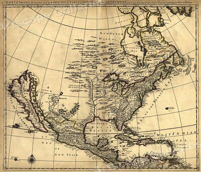
$5.95 Shipping Condition: New Location: Las Vegas, United States North America 1685 Size: 24" x 28" 61 cm x 86 cm) x Also Available in from our eBay Store This is a great Classic Map originally Published circa ... more1685. This Map shows what was known of America(North America) in1685. The wording reads: North America divided into its III principall parts. Features include: New North Wales" Canada) Bay of Mexico" Gulf of Mexico) Sea of the English Empire" Atlantic Ocean) West Indian Sea" Caribbean) Sea of California" Sea of New Spain" Pacific Ocean) New Mexico" Western United States) and"Tract of Land full of Wild Bulls" Great Plains) This poster. Which evokes the vivid images of a simpler time, is a custom reproduction printed on 68lb Heavyweight Enhanced Matte Art Paper. This Historic Art Print is suitable for framing. Mounting or direct display on any wall! 000 Artscape Galleries/ Posters Past More Prints and Posters Available from our eBay Store! Shipping price includes delivery confirmation. We combine shipping for multiple purchases- add $1.00 for each additional poster. All posters are professionally packaged to ensure that they arrive safely and undamaged: Your poster is first rolled and inserted into a plastic sleeve before being placed into a Heavy-Duty mailing tube for delivery. We stand behind the quality of every poster. If you are not satisfied with your purchase. Please contact us within 30 days to arrange for either an exchange or a full refund. gsrx_vers_468(GS 6.4(468)
$29.03 Shipping Location: WREXHAM, United Kingdom Produced by the Admiralty. This was part of the collection of the renowned C20th adventurer, Captain H. C. Sowerby.27.5” x 40”
Buy It Now
$4.13 Shipping Location: Malvern, United States Madagascar hooks to the right slightly, and the island chains in the Indian Ocean underline the intense exploration that had occurred since Vasco da Gama ... morereached India via the Cape of Good Hope in 1498.
Buy It Now
$4.95 Shipping Location: Dover, United States Champlain's Attack on Indian Fort in Western N.Y. Issued 1849, Albany, New York by Gavit. Engraved by J.E. Gavit. Printed image displays light to moderate ... morescattered age spotting, but remains attractive and worthy of display.
Buy It Now
$10.00 Shipping Location: Chicago, United States Condition: This important map is in B condition. A strong impression on heavy paper, it has a slightly rolled centerfold and browning around the edge ... morebut not touching the image, caused by previous matting.
Buy It Now
$6.95 Shipping Location: Dover, United States (Asia, India, British Raj, Afghanistan, China, Southeast Asia, Malaysia, Indonesia, Philippines, Australia, Indian Ocean). Issued c. 1830's, London by ... moreCharles Knight. Engraved by J. & C. Walker. Early 19th century engraved map with original outline hand color.
Buy It Now
Free Shipping Location: Anaheim, United States Title Panel Text:Coachella Valley of Riverside & Southern california - featuring the cities of COACHELLA, DESERT HOT SPRINGS, INDIAN WELLS, and PALM SPRINGS. ... moreand the unincorporated communities of Cathedral City, La Quinta, North Palm Springs, Palm Desert, Rancho Mirage, Thermal, and Thousand Palms.
Buy It Now
$30.00 Shipping Location: Paris VI, France During a stopover, he stopped in Mauritius in March 1801. On his way back, he continued his geographical, physical and botanical explorations on the island ... moreof Sainte-Hélène. L arge unusual antique view of Mauritius, Indian ocean, drawn by Bory de St Vincent.
Buy It Now
$4.95 Shipping Location: Dover, United States Issued for a 1939 World's Fair publication, printed with unrelated text on the reverse. Charming little mid-20th century pictorial map worthy of framing ... morefor display. Issued 1939, New York, art work by Norman Reeves.
Buy It Now
Location: South Bend, United States Chicago IL.
Buy It Now
$4.95 Shipping Location: Dover, United States (Map, Oceania, Australia, Indian Ocean, New South Wales, Tasmania ). Map is large folio, so one side is a map depicting only Australia in detail. Opened ... morethe map shows all of Oceania. The final map on the reverse of the sheet is Northern Africa around Morocco & Algeria.
Buy It Now
$6.20 Shipping Location: Rochester, United States Map is an authentic original good in condition as shown in photos.
Buy It Now
$35.00 Shipping Location: Minneapolis, United States 19th C MAP- East Canada and New Brunswick. ca 1850-- "Seal" of Queen Victoria on right side. Illus by H. Warren and Engraved by J B Allen. Map by J Rapkin. ... moreprinter- J and F Tallis London Edinburgh and Dublin.
Buy It Now
Free Shipping Location: Sayville, United States On one leaf of the rear is a map of the North & South Poles. See photo's.
Buy It Now
$10.04 Shipping Condition: Used Location: LONDON, United Kingdom Antique engraved atlas map with original hand colour/color, 1860. DATE PRINTED: 1860. TYPE: Antique engraved atlas map with original hand colour/color. ... moreAUTHENTICITY: This is an authentic historic print, published at the date stated above.
Buy It Now
$11.85 Shipping Location: Dover, United States Map engraved by Rapkin. Vignettes drawn by J. Marchant & engraved by J. Rogers. Missouri Territory is massive and straddles a long oddly shaped narrow ... moreNebraska Territory. Lovely mid 19th century engraved decorative map with original outline hand color.
Buy It Now
$28.06 Shipping Location: GULLANE, United Kingdom PLANS IN THE COMORO ISLANDS. COMORO ISLAND. BRITISH ADMIRALTY SEA CHART, titled. Originally Published at the British Admiralty, 8th July, 1895. Engraved ... more1895. INDIAN OCEAN. There are two Rose Compasses shown on this chart.
|
|
|
|
Vtg Inlaid Wood Panel Plaque Ocean Ship Indians Palm Trees Volcano Man Marquetry
Vtg Inlaid Wood Panel Plaque Ocean Ship Indians Palm Trees Volcano Man Marquetry Description: This is a Vintage Inlaid Wood Panel Plaque Picture Possibly Image of Ponce De Leon Landing in Puerto Rico showing the Ocean. A Ship, Indians, Palm Trees and Volcano. It measures approx 18.25" x 12.25" x.25" Is shows some light signs of wear. It is a really neat image. Please supersize all of the images as they are part of the description. We will combine shipping whenever possible. I take great pride in my customer service and make every attempt to describe each item as accurately as possible. This is a vintage item and has been used. It is not store new, therefore, it is being sold AS IS, so please email me with any questions you may have and be specific as you can so you have all the information you need to bid on it. Please ask ... moreany and all questions early. We usually do not go into the office on weekends or holidays and will not be able to answer questions until Mondays. We might be able to answer certain questions but anything re: measurements. Or anything very specific usually will not be answered until Monday. Any white spots and/or lines you may see are a reflection from the flash and/or lighting in the room. They are not on the item itself. INTERNATIONAL BIDDERS: Please do not ask us to put false information on the customs papers. We will not. Please note that when you are selecting a shipping method during checkout for items under 4 pounds that ONLY Priority Mail International can be tracked through delivery First Class International CANNOT. As such, if you select First Class International Shipping it is AT YOUR OWN RISK. Thanks for looking and bidding. Wall.
|
|
|
1789 CAPTAIN James COOK Pacific OCEAN Maritime HAWAII Sandwich ISLANDS Indians
Cook. Captain James. Perth: Printed by R. Morison, Jun. 1789. The official account of Cook's third and final voyage. Undertaken to seek the Northwest Passage from the Pacific. The officers of this voyage aboard the Resolution form a who's who of later Pacific exploration, including William Bligh, George Vancouver, and James Burney. Cook visited New Zealand, Tahiti, and other islands before making what he considered his greatest discovery, the Hawaiian Islands, which he named the Sandwich Islands. Cook then headed north reaching present-day Oregon, then following the coast north to Alaska, sailing through the Bering Strait, where the ship was stopped by pack ice in August of 1778. In January 1779 Cook returned to the Hawaiian Islands where he had previously been welcomed, but tensions quickly mounted, prompting Cook to set sail on ... moreFebruary 4. Several days later a storm broke the Resolution's foremast, and Cook returned to the islands to make repairs. The natives, not happy to see the Englishmen again stole of the ship's boats, Cook took a Hawaiian chief hostage and was killed returning to the ship with his prisoner. The first two volumes of this set are from Cook's journals(not present) the third volume was written by Captain James King, who succeeded Cook(this volume) and the fourth volume is the scarce atlas(also not present) Original leather binding. As shown with some weathering, rounding and some leather splitting. Ruled spine with red leather label. Hinges intact. Some pen and pencil squiggles and inscriptions from a young Hezekiah Keirstead of Gagetown, New Brunswick, Canada. See more on him below. Pages with some scattered staining and browning, but all intact. Sadly, lacking pp 121-128, 131-134; the rest present and complete. There is a central split in the binding where the pages are lacking, with a few detached as a result, please note. Page edges marbled as well. Small 8vo. Good luck! GENEALOGY Hezekiah Keirstead b. 24 Nov 1793. Gagetown, Queens, New Brunswick, Canada, d. 25 Dec 187
|
|
|
1785 CAPTAIN James COOK Pacific OCEAN Maritime HAWAII Sandwich ISLANDS Indians
Cook. Captain James. London: Printed for Scatchard& Co. and John Stockdale, Piccadilly, 1785] 1st Edition. The official account of Cook's third and final voyage. Undertaken to seek the Northwest Passage from the Pacific. The officers of this voyage aboard the Resolution form a who's who of later Pacific exploration, including William Bligh, George Vancouver, and James Burney. Cook visited New Zealand, Tahiti, and other islands before making what he considered his greatest discovery, the Hawaiian Islands, which he named the Sandwich Islands. Cook then headed north reaching present-day Oregon, then following the coast north to Alaska, sailing through the Bering Strait, where the ship was stopped by pack ice in August of 1778. In January 1779 Cook returned to the Hawaiian Islands where he had previously been welcomed, but tensions ... morequickly mounted, prompting Cook to set sail on February 4. Several days later a storm broke the Resolution's foremast, and Cook returned to the islands to make repairs. The natives, not happy to see the Englishmen again stole of the ship's boats, Cook took a Hawaiian chief hostage and was killed returning to the ship with his prisoner. An abridgement of the account of the voyage by Captain James Cook and Captain James King. The titlepage is engraved. And includes part of the Cook's coat of arms. Original leather spine, as shown with some weathering, light leather loss and wear, as shown. Ruled spine with red leather label. Lacking boards. Pages with some scattered staining and browning, a few leaves with chips and small tears. Plates as shown; all called for are present except for frontis. Complete lest for frontis and final leaf of text. 2] Xii, 370 of 372 pages, 6] leaves of plates. Good luck!
|
|
|
VTG NATIONAL GEOGRAPHIC MAP LOT WORLD ASIA EUROPE INDIANS MARS OCEAN US STATES
Normal 0 false false false EN-US X-NONE X-NONE HELLO WELCOME TO MY AUCTION! Thank you for your time and interest in my item! Please take a moment to review my POSITIVE FEEDBACK* YOU ARE BIDDING ON A VINTAGE NATIONAL GEOGRAPHIC MAP LOT…VERY NICE VARIETY OF MAPS…ALL IN GOOD TO VERY GOOD CONDITIONS…WELL KEPT BY THE ORIGINAL OWNER…MOST ARE BEAUTIFULLY ILLUSTRATED…VERY COOL MIX COLLECTION MAPS ARE FROM THE 1960s TO 1980s…EVERYTHING FROM MARS. THE HEAVENS TO OCEANS THE US STATES, NATIVE AMERICANS EUROPE AND ASIA( SOME RARE SOME COMMON) 3 WORLD MAPS IN THIS LOT…GREAT COLLECTION FOR A CLASS ROOM SETTING OR THE NAT. GEO. MAP COLLECTOR A TOTAL OF 78 MAPS( 6 ARE DUPLICATES) ALSO INCLUDED IS A 1965“SAMPLE MAP” FEATURING THE DURABLE PLASTIC COATED PAPER OF THE“CLOSE-UP” MAPS…VINTAGE SALES SAMPLE NO RESERVE…ONLY $49.99 FREE S/H TO THE USA WITH DELIVERY ... moreCONF. TRACKING# THIS WAS A RECENT FIND AT A ESTATE SALE… FROM A CLEAN SMOKE FREE ESTATE…ORIGINAL OWNER HAD SEVERAL NATIONAL GEOGRAPHIC COLLECTIONS…ALL THE MAPS WERE WELL PROTECTED STORED FLAT FOR YEARS IN THE NATIONAL GEOGRAPHIC MAGAZINES…FOUND STORED IN A CLIMATE CONTROLLED ENVIRONMENT…THE ONLY MAP I FOUND WITH DAMAGE IS ONE OF THE WORLD MAPS HAS SPLIT FROM AGE IN THE CENTER…IT IS NOT RIPPED…IT HAS SEPARATED ON ONE OF THE FOLD SEAMS DUE TO AGE…ALL MAPS HAVE VERY HIGH QUALITY PRINT AND PAPER AS NAT. GEO IS KNOWN FOR…AWESOME LOT COLLECTION THE LOT INCLUDES: THE POLITICAL& PHYSICAL WORLD 1975( AGE SPLIT ON SEAM…NOT TORN) THE POLITICAL WORLD 1975 THE WORLD 1970 WHALES OF THE WORLD 1976 ARTIC OCEAN FLOOR 1971 INDIAN OCEAN FLOOR 1967 TEAMMATES IN MANKINDS GREATEST ADVENTURE 1973(MOON APOLLO TEAM…AWESOME ILLUSTRATION) THE RED PLANET MARS 1973 THE HEAVENS/ STAR CHARTS 1970 HISTORIC MEDITERRANEAN 1982 MEDIEVAL ENGLAND 1979 HISTORY OF EUROPE(MAJOR TURING POINTS) 1983 EUROPE 1969 BRITISH ISLES TRAVELERS GUIDE MAP 1974(QTY OF 2) DISCOVERERS OF THE PACIFIC 1974 CANADA’S VACATIONLANDS 1985 CLOSE-UP CANADA/ SASKATCHEWAN MANITOBA NORTH WEST TERRITORIES 1979 CLOSE-UP CAN
|
|
|
Lot of 16 wall maps all National Geographic from 1970's Ocean floor, Indians pls
Hello. You are bidding on a Lot of 16 wall maps all National Geographic from 1970's Ocean floor, Indians of North America, and many other world maps. They are all Supplements to National Geographic magazines from the early 1970's Please see actual photos for condition. I took a close up of them in pairs, and opened the map of Canada. all maps are 2 sided. Please feel free to email me with any questions. And thanks for looking. We are always striving for 100% customer satisfaction, If you do not feel like you have received a 5 star transaction, please let us know. Please check out all the items in our store.
|
|
 |