Buy It Now
$7.00 Shipping Location: Rockville, United States Up for sale is a great, large, antique map of a small set of blocks in N.W. DC. This map is from the Real Estate Plat-Book of Washington, District of ... moreColumbia. "Comprising the entire North-West Section from the Original Plats of Squares & Subdivisions and Additions upon record in the office of the Surveyor of the City of Washington".

Buy It Now
$7.00 Shipping Location: Rockville, United States Up for sale is a great. Large, antique map of a small set of blocks in N.W. DC. This map has property specific detail of the area between K Street and ... moreN Street and stretches from the 7th Street to 3rd Street. This area includes Mount Vernon Square,and the upper part of Chinatown. The Convention Center sits at the corner of 7th and NW Avenue, just to the left of this map. Interstate 395 now runs up Area 526 and 525. The Police Station in area 481 has been replaced by apartment buildings. Madison Street in Area 448 is now called Emmanuel Court. Most of the other buildings are now residential. The"Nothern Liberty Market Co. Lot 108 in the bottom middle of the map, is now residential buildings with shop on the street level. This map measures approximately 28 1/2 x 22 1/2 inches. Including the border area. Property specific detail. Map is in color. VERY RARE. This map is from the Real Estate Plat-Book of Washington. District of Columbia. Vol. 1. Comprising the entire North-West Section from the Original Plats of Squares& Subdivisions and Additions upon record in the office of the Surveyor of the City of Washington" Constructed under the direction of and published in 1892 by Griffith M. Hopkins, in Philadelphia, Pennsylvania. Maps this early and showing this much detail of Washington D.C. are VERY SCARCE. The map has fantastic coloring to it. Lots of color coding to represent various attributes(white/stone building. Pink/brick building, yellow/frame building, if it looks like an envelope/a stable or shed, and black& white dotted/green house etc. Map in generally good condition(not perfect but pretty nice condition) Some browning and small chips or creases at edges. Map is blank on the reverse side. There is a crease up the middle where it was originally bound. The map has some small tears and chips around the edges. A brown square stain can be found in the bottom of the right edge and the bottom of the left edge of the map. Caused by the original binding. There are some black scuff marks along the lef

Buy It Now
$7.00 Shipping Location: Rockville, United States Up for sale is a great. Large, antique map of a small set of blocks in N.W. DC. This map has property specific detail of the area between B Street(now ... moreConstitution Avenue) and New York Avenue and constituting the area stretching from 19th Street to 17th Street. To the right of 17th Street you would now find the Ellipse. DAR Constitution Hall is now located in Area 173 of this map. The Department of the Interior currently sits on the Areas comprising of 144 and 145 and the Corcoran Gallery of Art is now located in Section 171 of this map. This map measures approximately 14 x 22 1/2 inches. Including the border area. Property specific detail. Map is in color. VERY RARE. This map is from the Real Estate Plat-Book of Washington. District of Columbia. Vol. 1. Comprising the entire North-West Section from the Original Plats of Squares& Subdivisions and Additions upon record in the office of the Surveyor of the City of Washington" Constructed under the direction of and published in 1892 by Griffith M. Hopkins, in Philadelphia, Pennsylvania. Maps this early and showing this much detail of Washington D.C. are VERY SCARCE. The map has fantastic coloring to it. Lots of color coding to represent various attributes(white/stone building. Pink/brick building, yellow/frame building, if it looks like an envelope/a stable or shed, and black& white dotted/green house etc. Map in generally good condition(not perfect but pretty nice condition) Some browning and small chips or creases at edges. Map is blank on the reverse side. The map has some small tears and chips around the edges. A brown square stain can be found in the middle of the right edge. Caused by the original binding. There may be some pencil marks left by a previous owner. There are some creases in the paper. But they do not affect the map, as well as some other stains here and there. Some other dings here and there. This map is a great piece of Washington. D.C. history! It will look very nice when framed. Please note that while I have included a picture o

Buy It Now
$7.00 Shipping Location: Rockville, United States Up for sale is a great. Large, antique map of a small set of blocks in N.W. DC. This map has property specific detail of the area between L Street and ... moreN Street and stretches from 19th Street(South of Dupont Circle) to 16th Street(Scott Circle) The"Visitation Academy" in Area 162 is now where the Mayflower Renaissance Hotel sits. The DC Improve Comedy Club currently sits on the green triangle(right of Area 139) at the corner of Connecticiut and 18th and M Streets. This map measures approximately 28 1/2 x 22 1/2 inches. Including the border area. Property specific detail. Map is in color. VERY RARE. This map is from the Real Estate Plat-Book of Washington. District of Columbia. Vol. 1. Comprising the entire North-West Section from the Original Plats of Squares& Subdivisions and Additions upon record in the office of the Surveyor of the City of Washington" Constructed under the direction of and published in 1892 by Griffith M. Hopkins, in Philadelphia, Pennsylvania. Maps this early and showing this much detail of Washington D.C. are VERY SCARCE. The map has fantastic coloring to it. Lots of color coding to represent various attributes(white/stone building. Pink/brick building, yellow/frame building, if it looks like an envelope/a stable or shed, and black& white dotted/green house etc. Map in generally good condition(not perfect but pretty nice condition) Some browning and small chips or creases at edges. Map is blank on the reverse side. There is a crease up the middle where it was originally bound. The map has some small tears and chips around the edges. A brown square stain can be found on the top right edge and the top left edge of the map. Caused by the original binding. There are a few pencil marks left by a previous owner. There are some black smudges in the left hand border. There are some creases in the paper, but they do not affect the map, as well as some other stains here and there. Some other dings here and there. This map is a great piece of Washington. D.C. history! It will look
Buy It Now
$6.00 Shipping Location: North Wales, United States 1892 ANTIQUE CRAM ATLAS MAP OF THE INDIAN EMPIRE-EXCELLENT DETAIL ORIGINAL ANTIQUE ATLAS MAP PLEASE SEE PHOTOS AS PART OF THE DESCRIPTION CONDITION: MAP ... moreIS IN GOOD CONDITION. SIZE: APPROXIMATELY 11" X 14" SHIPPING: U.S. FIRST CLASS RATE - $6.00 - ANY ITEM WHICH SELLS FOR OVER $100 WILL REQUIRE INSURANCE WE COMBINE SHIPPING FOR MULTIPLE WINS. THANK YOU FOR YOUR INTEREST IN OUR AUCTIONS!.
Buy It Now
$4.00 Shipping Location: United States Very detailed and attractive period map. This is an antique map and not a reprint or reproduction, beautiful period map. The handcoloring on the map is ... moreperiod to the map, this is before color printing.
Buy It Now
$40.00 Shipping Location: Media, United States Delaware County Delco is near Philadelphia, Pennsylvania. The hard back hardback book has a great stamped/embossed cover as pictured. It has reinforced ... morecorners. The first 2-page map is titles "Driving And Outline Map Of Delaware County, Penna., Scale 1 1/2" = 1 Mile".
Buy It Now
$17.00 Shipping Location: Edwards, United States Discover a stunning antique map from Julius Bien featuring the town of Cortlandt, Peekskill, and Croton On Hudson in New York. The lithography printing ... moretechnique used to create this map in 1892 is truly remarkable. The map is an original antique and comes unframed. The map showcases the Town of Cortlandt in great detail, highlighting the beautiful city of Peekskill and the charming village of Croton on Hudson. This County Map is a must-have for any collector or history enthusiast. Don't miss out on the opportunity to own this incredible piece of history! The map measures 20” x 30” and has a lateral fold. This is in a vintage condition and will be carefully wrapped and shipped in a tube.
Buy It Now
$4.99 Shipping Location: Fairview, United States Stieler's Hand Atlas, published in Gotha by Justus Perthes. The publisher is stated in the bottom center, the title of the atlas is in the upper right ... morecorner and the printing details in the bottom left margin.
Buy It Now
$6.00 Shipping Location: Corunna, United States This plat map is from a Elkhart County Indiana plat book published by Geo. A. Ogle & Co. in 1892. This is an original 130 year old map, not a copy or ... morereprint.
Buy It Now
$3.65 Shipping Location: United States Nicely detailed and attractive period map. Much has changed since 1892. Fine perod color lithography, printed on thick paper. There is text on reverse ... morebut you cant see it looking at the map as the paper is too thick.
Buy It Now
$8.50 Shipping Location: Croatia (1875-94), great work of Elisee Reclus. The unusually steep-sided valleys and massive, rounded uplands comprise a natural wilderness within easy reach ... moreof New York City. The mountains were made famous through Washington Irving's short stories about the legendary Rip Van Winkle, who supposedly took his long nap near the town of Catskill, on the Hudson River at the eastern entrance to the park.
Buy It Now
$4.99 Shipping Location: Fairview, United States Stieler's Hand Atlas, published in Gotha by Justus Perthes. The publisher is stated in the bottom center, the title of the atlas is in the upper right ... morecorner and the printing details in the bottom left margin.
Buy It Now
$6.95 Shipping Location: Dover, United States Issued 1892, Leipzig, Germany by the Bibliographische Institut. Late 19th century color lithographed map. Original center fold as issued.

Buy It Now
$7.00 Shipping Location: Rockville, United States Up for sale is a great. Large, antique map of a small set of blocks in N.W. DC. This map has property specific detail of the area between D Street and ... moreG Street and stretches from 3rd Street to North Capital Street. Area 569 on this map now houses the Georgetown University Law Center. The Hyatt Regency Hotel now sits in the entire section marked Area 629 on this map. This are is just west of Union Station, which sits on the other side of North Capitol Street. This map measures approximately 28 1/2 x 22 1/2 inches. Including the border area. Property specific detail. Map is in color. VERY RARE. This map is from the Real Estate Plat-Book of Washington. District of Columbia. Vol. 1. Comprising the entire North-West Section from the Original Plats of Squares& Subdivisions and Additions upon record in the office of the Surveyor of the City of Washington" Constructed under the direction of and published in 1892 by Griffith M. Hopkins, in Philadelphia, Pennsylvania. Maps this early and showing this much detail of Washington D.C. are VERY SCARCE. The map has fantastic coloring to it. Lots of color coding to represent various attributes(white/stone building. Pink/brick building, yellow/frame building, if it looks like an envelope/a stable or shed, and black& white dotted/green house etc. Map in generally good condition(not perfect but pretty nice condition) Some browning and small chips or creases at edges. Map is blank on the reverse side. There is a crease up the middle where it was originally bound. The map has some small tears and chips around the edges. A brown square stain can be found in the bottom of the right edge and the bottom of the left edge of the map. Caused by the original binding. There are some black scuff marks along the left and bottom edge. There are a lot of pencil marks left by a previous owner. Mostly in the upper right hand corner. There are some creases in the paper, but they do not affect the map, as well as some other stains here and there. Some other dings here and there. This map
Buy It Now
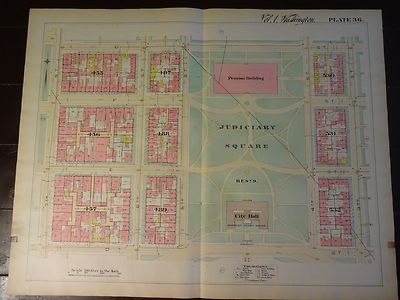
$7.00 Shipping Location: Rockville, United States Up for sale is a great. Large, antique map of a small set of blocks in N.W. DC. This map has property specific detail of the area between D Street and ... moreG Street and stretches from the 7th Street to 3rd Street. This is known as the Judiciary Square area of Northwest. The Judiciary Square Metro Station now sits on 4th Street between Area 531 and Area 532. The National Building Museum now sits where this map shows the Pension Building above Judiciary Square. The Verizon Center sits at 601 F Street and now takes up the entire block of Area 455. Interstate 395 now runs just to the east of 3rd Street and Area 532. The District of Columbia Court of Appeals is in the City Hall spot on this map. This map measures approximately 28 1/2 x 22 1/2 inches. Including the border area. Property specific detail. Map is in color. VERY RARE. This map is from the Real Estate Plat-Book of Washington. District of Columbia. Vol. 1. Comprising the entire North-West Section from the Original Plats of Squares& Subdivisions and Additions upon record in the office of the Surveyor of the City of Washington" Constructed under the direction of and published in 1892 by Griffith M. Hopkins, in Philadelphia, Pennsylvania. Maps this early and showing this much detail of Washington D.C. are VERY SCARCE. The map has fantastic coloring to it. Lots of color coding to represent various attributes(white/stone building. Pink/brick building, yellow/frame building, if it looks like an envelope/a stable or shed, and black& white dotted/green house etc. Map in generally good condition(not perfect but pretty nice condition) Some browning and small chips or creases at edges. Map is blank on the reverse side. There is a crease up the middle where it was originally bound. The map has some small tears and chips around the edges. A brown square stain can be found in the bottom of the right edge and the bottom of the left edge of the map. Caused by the original binding. There are some black scuff marks along the left edge. There are a few pencil marks le
Buy It Now
$6.25 Shipping Location: Denver, United States This is an original 1892 map of Maryland and Delaware, published by Geo W Cram. It is in exquisite shape, with no foxing. If you've seen print ads used ... morein set decoration for TV shows or films, you've likely seen our ads.
Buy It Now
$7.00 Shipping Location: North Wales, United States 1892 RARE ANTIQUE CRAM ATLAS MAP-EDINBURGH-EXCELLENT DETAIL ORIGINAL ANTIQUE ATLAS MAP PLEASE SEE PHOTOS AS PART OF THE DESCRIPTION CONDITION: MAP IS ... moreIN GOOD CONDITION SIZE: APPROXIMATELY 6" X 9" SHIPPING: U.S. FIRST CLASS RATE - $7.00. CANADA - $20.00. WORLDWIDE - $25.00 ANY ITEM WHICH SELLS FOR OVER $100 WILL REQUIRE INSURANCE. WE COMBINE SHIPPING FOR MULTIPLE WINS. THANK YOU FOR YOUR INTEREST IN OUR AUCTIONS!.
Buy It Now
$8.50 Shipping Location: Croatia Deep inlet of the eastern North Pacific Ocean indenting northwestern Washington, U.S. It stretches south for 100 miles (160 km) from Admiralty Inlet and ... moreWhidbey Island (beyond which lie the straits of Georgia and Juan de Fuca).
Buy It Now
$4.99 Shipping Location: Fairview, United States Stieler's Hand Atlas, published in Gotha by Justus Perthes. The publisher is stated in the bottom center, the title of the atlas is in the upper right ... morecorner and the printing details in the bottom left margin.
Buy It Now
$4.55 Shipping Location: Oakland, United States This stunning antique map of Alabama from 1892 is a true treasure for any map collector or history enthusiast. Measuring approximately 13x11 inches, it ... moreshowcases the state's topographical features and important landmarks with intricate details that will amaze you. The map is in its original form and has been well-preserved over the years. Featuring a rich color palette and fine print quality, this map is a rare find that is sure to add value to any collection. Its authenticity and historical significance make it a great addition to any museum or educational setting. Whether you're a seasoned collector or just starting out, this antique map of Alabama is a must-have for anyone who appreciates the beauty and importance of cartography.
Buy It Now
$3.65 Shipping Location: United States Beautiful map. Fine color lithography. There is text on reverse, but you cant see it looking at the image as the paper is too thick. The size of the map ... moreis 11.5" by 14". FREE scheduling, supersized images.
Buy It Now
$4.99 Shipping Location: Fairview, United States "Ball's Atlas of Astronomy" is printed in the upper left corner and the publishing details are in the bottom center. An Authentic Antique Print: Not a ... moreModern Reproduction!
Buy It Now
$5.00 Shipping Location: Canada DATE OF ISSUE: 1892.
Buy It Now
$4.99 Shipping Location: Fairview, United States Stieler's Hand Atlas, published in Gotha by Justus Perthes. The publisher is stated in the bottom center, the title of the atlas is in the upper right ... morecorner and the printing details in the bottom left margin.
Buy It Now
Free Shipping Condition: New Location: Orlando, United States This includes 3 copies of Gleason's New Standard Map Of The World - Large 24" x 36" from 1892. Its is large and detailed. This is the real deal.
Buy It Now
$6.00 Shipping Location: North Wales, United States 1892 ANTIQUE CRAM ATLAS MAP OF SCOTLAND-EXCELLENT DETAIL ORIGINAL ANTIQUE ATLAS MAP PLEASE SEE PHOTOS AS PART OF THE DESCRIPTION CONDITION: MAP IS IN ... moreGOOD CONDITION. SIZE: APPROXIMATELY 11" X 14" SHIPPING: U.S. FIRST CLASS RATE - $6.00 - ANY ITEM WHICH SELLS FOR OVER $100 WILL REQUIRE INSURANCE WE COMBINE SHIPPING FOR MULTIPLE WINS. THANK YOU FOR YOUR INTEREST IN OUR AUCTIONS!.
Buy It Now
$4.00 Shipping Location: United States One side is a fine antique map titled West Lebanon PO, reverse is Monroe, Lyman & Bath, with inset map of Monroe PO. This is an antique 1892 map and not ... morea reprint or reproduction. The size of the map is 17.5" by 14".
Buy It Now
$7.00 Shipping Location: Rockville, United States Up for sale is a great, large, antique map of a small set of blocks in N.W. DC. In the bottom left hand corner (area 9) we can now find the Watergate ... moreComplex. The Lybian Empassy currently sits in Area 7 and the Embassy of Saudi Arabia is now located in Area 19.

Buy It Now
$7.00 Shipping Location: Rockville, United States Up for sale is a great. Large, antique map of a small set of blocks in N.W. DC. This map has property specific detail of the area between K Street and ... moreN Street and stretches from the 7th Street to 3rd Street. This area includes Mount Vernon Square,and the upper part of Chinatown. The Convention Center sits at the corner of 7th and NW Avenue, just to the left of this map. Interstate 395 now runs up Area 526 and 525. The Police Station in area 481 has been replaced by apartment buildings. Madison Street in Area 448 is now called Emmanuel Court. Most of the other buildings are now residential. The"Nothern Liberty Market Co. Lot 108 in the bottom middle of the map, is now residential buildings with shop on the street level. This map measures approximately 28 1/2 x 22 1/2 inches. Including the border area. Property specific detail. Map is in color. VERY RARE. This map is from the Real Estate Plat-Book of Washington. District of Columbia. Vol. 1. Comprising the entire North-West Section from the Original Plats of Squares& Subdivisions and Additions upon record in the office of the Surveyor of the City of Washington" Constructed under the direction of and published in 1892 by Griffith M. Hopkins, in Philadelphia, Pennsylvania. Maps this early and showing this much detail of Washington D.C. are VERY SCARCE. The map has fantastic coloring to it. Lots of color coding to represent various attributes(white/stone building. Pink/brick building, yellow/frame building, if it looks like an envelope/a stable or shed, and black& white dotted/green house etc. Map in generally good condition(not perfect but pretty nice condition) Some browning and small chips or creases at edges. Map is blank on the reverse side. There is a crease up the middle where it was originally bound. The map has some small tears and chips around the edges. A brown square stain can be found in the bottom of the right edge and the bottom of the left edge of the map. Caused by the original binding. There are some black scuff marks along the lef

Buy It Now
$7.00 Shipping Location: Rockville, United States Up for sale is a great. Large, antique map of a small set of blocks in N.W. DC. This map has property specific detail of the area between E Street and ... moreH Street and stretches from the President's House to 13th Street. The U.S. Treasury Department still sits in the same place. Pennsylvania Avenue is no longer open to vehicle traffic from 15th Street over to 17th Street, between Lafayette Square and The White House. The New York Avenue Presbyterian Church still sits at the corner of New York Avenue and H Street(Area 251) and the Church of the Epiphany is still located on G Street(Area 252) The New National Theatre in Area 254 is where today's National Theatre still stands. The historic Willard Hotel can still be found at 1401 Pennsylvania Avenue(Area 225) This map measures approximately 28 1/2 x 22 1/2 inches. Including the border area. Property specific detail. Map is in color. VERY RARE. This map is from the Real Estate Plat-Book of Washington. District of Columbia. Vol. 1. Comprising the entire North-West Section from the Original Plats of Squares& Subdivisions and Additions upon record in the office of the Surveyor of the City of Washington" Constructed under the direction of and published in 1892 by Griffith M. Hopkins, in Philadelphia, Pennsylvania. Maps this early and showing this much detail of Washington D.C. are VERY SCARCE. The map has fantastic coloring to it. Lots of color coding to represent various attributes(white/stone building. Pink/brick building, yellow/frame building, if it looks like an envelope/a stable or shed, and black& white dotted/green house etc. Map in generally good condition(not perfect but pretty nice condition) Some browning and small chips or creases at edges. Map is blank on the reverse side. There is a crease up the middle where it was originally bound. The map has some small tears and chips around the edges. A brown square stain can be found in the middle of the right edge and the middle of the left edge of the map. Caused by the original binding. There are

Buy It Now
$7.00 Shipping Location: Rockville, United States Up for sale is a great. Large, antique map of a small set of blocks in N.W. DC. This map has property specific detail of the area between T Street and ... moreFlorida Avenue and stretches from 16th Street to 13th Street. This area is currently known at the Shaw neighborhood(named after Union Colonel Robert Gould Shaw, the commander of the 54th Massachusetts Volunteer Infantry during the Civil War. The Stretch from 16th Street to 14th along U Street is also part of the"U Street Corridor" This map measures approximately 28 1/2 x 22 1/2 inches. Including the border area. Property specific detail. Map is in color. VERY RARE. This map is from the Real Estate Plat-Book of Washington. District of Columbia. Vol. 1. Comprising the entire North-West Section from the Original Plats of Squares& Subdivisions and Additions upon record in the office of the Surveyor of the City of Washington" Constructed under the direction of and published in 1892 by Griffith M. Hopkins, in Philadelphia, Pennsylvania. Maps this early and showing this much detail of Washington D.C. are VERY SCARCE. The map has fantastic coloring to it. Lots of color coding to represent various attributes(white/stone building. Pink/brick building, yellow/frame building, if it looks like an envelope/a stable or shed, and black& white dotted/green house etc. Map in generally good condition(not perfect but pretty nice condition) Some browning and small chips or creases at edges. Map is blank on the reverse side. There is a crease up the middle where it was originally bound. The map has some small tears and chips around the edges. A brown square stain can be found on the top right edge and the top left edge of the map. Caused by the original binding. There are a few pencil marks left by a previous owner. There are some black smudges in the left hand border, as well as some larger stains in Area 188. There are some creases in the paper, but they do not affect the map, as well as some other stains here and there. Some other dings here and there. This map
Buy It Now
$5.00 Shipping Location: North Wales, United States 1892 RARE ANTIQUE CRAM ATLAS MAP-AFRICA-EXCELLENT DETAIL ORIGINAL ANTIQUE ATLAS MAP PLEASE SEE PHOTOS AS PART OF THE DESCRIPTION CONDITION: MAP IS IN ... moreGOOD CONDITION SIZE: APPROXIMATELY 14" X 22" SHIPPING: U.S. FIRST CLASS RATE - $7.00. CANADA - $20.00. WORLDWIDE - $25.00 ANY ITEM WHICH SELLS FOR OVER $100 WILL REQUIRE INSURANCE. WE COMBINE SHIPPING FOR MULTIPLE WINS. THANK YOU FOR YOUR INTEREST IN OUR AUCTIONS!.
Buy It Now
$8.50 Shipping Location: Croatia Grant's presence forced much of the city's trade to be diverted to Chicago. The city was protected by its levees from destruction when the Ohio River ... morerose to record heights during the 1937 flood. In the late 1960s and early 1970s Cairo was the scene of racial strife, and it fell into a serious decline thereafter.
Buy It Now
$8.50 Shipping Location: Croatia
Buy It Now
$3.65 Shipping Location: United States Fine antique 1892 color lithographed map, titled Virginia and West Virginia, with detailed chart corresponding to the map itself. Nicely detailed and ... moreattractive period map. Much has changed since 1892.
Buy It Now
$3.75 Shipping Location: United States A beautiful map. The superb handcoloring is period to the map, this is before color printing. This is an antique 1892 map and not a reprint or reproduction. ... moreThe map size is 17.5" by 14". FREE scheduling, supersized images.
Buy It Now
$6.00 Shipping Location: North Wales, United States 1892 ANTIQUE CRAM ATLAS MAP OF OHIO-EXCELLENT DETAIL ORIGINAL ANTIQUE ATLAS MAP PLEASE SEE PHOTOS AS PART OF THE DESCRIPTION CONDITION: MAP IS IN GOOD ... moreCONDITION. SIZE: APPROXIMATELY 11" X 14" SHIPPING: U.S. FIRST CLASS RATE - $6.00 - ANY ITEM WHICH SELLS FOR OVER $100 WILL REQUIRE INSURANCE WE COMBINE SHIPPING FOR MULTIPLE WINS. THANK YOU FOR YOUR INTEREST IN OUR AUCTIONS!.
Buy It Now
$7.00 Shipping Location: Rockville, United States Up for sale is a great, large, antique map of a small set of blocks in N.W. DC. The John F. Kennedy Center for the Performing Arts currently sits near ... morethe Potomac River in the Section 12 of this map.

Buy It Now
$7.00 Shipping Location: Rockville, United States Up for sale is a great. Large, antique map of a small set of blocks in N.W. DC. This map has property specific detail of the area between M street and ... more23rd. This map measures approximately 28 1/2 x 22 1/2 inches. Including the border area. Property specific detail. Map is in color. VERY RARE. This map shows an area of NW stretching from Rock Creek to M Street and then over to 23rd Street. This is currently lower Georgetown/ George Washington area of the city. Map from the Real Estate Plat-Book of Washington. District of Columbia. Vol. 1. Comprising the entire North-West Section from the Original Plats of Squares& Subdivisions and Additions upon record in the office of the Surveyor of the City of Washington" Constructed under the direction of and published in 1892 by Griffith M. Hopkins, in Philadelphia, Pennsylvania. Maps this early and showing this much detail of Washington D.C. are VERY SCARCE. Map has fantastic coloring to it. Lots of color coding to represent various attributes(white/stone building. Pink/brick building, yellow/frame building, if it looks like an envelope/a stable or shed, and black& white dotted/green house etc. Please note that while I have included a picture of the Title Page of the Plat-Book this map was taken from. It is NOT included in the sale, as it is a reference piece to determine authenticity for the other maps. I would be happy to include a copy if requested. Map in generally good condition(not perfect but pretty nice condition) Light browning and some small creases at edges. Some other dings here and there. This map is a great piece of Washington. D.C. history! It will look very nice when framed. Map is blank on the reverse side. There is a crease up the middle where it was originally bound. The map has moderate browning around the edges. As well as several tears and chips. A larger tear in the bottom left corner. 3 round brown stains in the border at the bottom of the map. A brown square stain on the top right edge of the map caused by the original binding. There
Buy It Now
$5.95 Shipping Location: Dover, United States Original center fold as issued. Attractive and detailed late 19th century color lithographed map. Made in Germany, German text.
Buy It Now
$4.99 Shipping Location: Charlotte, United States Large Antique 1892 Map Of The World & Polar Regions that shows Arctic discoveries along with Arms Of Nations! The detail is incredible for 130 years old. ... moreMap has an inset.
Buy It Now
$4.55 Shipping Location: Oakland, United States This magnificent antique map of Virginia and West Virginia from 1892 is a true gem for any collector or enthusiast of historical cartography. Measuring ... moreapproximately 13x11 inches, the map features intricate details and beautiful colors that showcase the unique topography of the region.With its stunning depiction of mountains, rivers, and cities, this atlas map is a must-have for anyone interested in the history of the two states. Its vintage charm and exquisite craftsmanship make it a conversation starter and a beautiful addition to any home or office decor. Don't miss this opportunity to own a piece of American history!
Buy It Now
$3.65 Shipping Location: United States Fine antique 1892 color lithographed map, titled Australia. Attractive period map, nicely detailed, and much has changed since 1892. Beautiful map. Fine ... morecolor lithography. There is text on reverse, but you cant see it looking at the image as the paper is too thick.
Buy It Now
$8.50 Shipping Location: Croatia City, Bristol county, southeastern Massachusetts, U.S. It lies on the east shore of Mount Hope Bay, at the mouth of the Taunton River, 18 miles (29 km) ... moresoutheast of Providence, Rhode Island. Bristol Community College was established (1966) in Fall River.
Buy It Now
$4.99 Shipping Location: Fairview, United States Condition: The map is in Very Good condition with very light tonal aging, otherwise very clean.The map was originally published on two facing pages which ... morewe have joined together with acid free materials.
Buy It Now
$4.99 Shipping Location: Fairview, United States "Ball's Atlas of Astronomy" is printed in the upper left corner and the publishing details are in the bottom center. An Authentic Antique Print: Not a ... moreModern Reproduction!
Buy It Now
$4.55 Shipping Location: Oakland, United States Explore the world in the late 19th century with these antique maps of the Western and Eastern Hemispheres. The carefully preserved pieces showcase the ... moreintricate details of the world atlas and measure approximately 13x11 inches. Perfect for collectors of antique maps, these pieces are sure to be a great addition to any North America Maps, Maps, Atlases & Globes, or Antiques collection. Don't miss your chance to own a piece of history!
Buy It Now
$3.65 Shipping Location: United States Fine antique 1892 color lithographed map, titled England & Wales, with detailed chart below the title corresponding to the map itself. Beautiful map. ... moreFine color lithography. There is text on reverse, but you cant see it looking at the image as the paper is too thick.
Buy It Now
$6.00 Shipping Location: Corunna, United States This plat map is from a Elkhart County Indiana plat book published by Geo. A. Ogle & Co. in 1892. This is an original 130 year old map, not a copy or ... morereprint.
Buy It Now
$4.99 Shipping Location: Fairview, United States Stieler's Hand Atlas, published in Gotha by Justus Perthes. The publisher is stated in the bottom center, the title of the atlas is in the upper right ... morecorner and the printing details in the bottom left margin.
Buy It Now
$4.00 Shipping Location: United States Fine large antique 1892 color lithographed map, titled Rand, McNally & Co.'s Map of the United States Showing the Increase and Decrease of Population, ... more1880 to 1890. Beautiful and detailed period population map of the United States.
Buy It Now
$8.50 Shipping Location: Croatia The snow-covered peaks, within the Coconino National Forest, support lumbering and tourism based on skiing, hiking, and other recreational activities.
Buy It Now
$6.00 Shipping Location: North Wales, United States 1892 ANTIQUE CRAM ATLAS MAP OF ARGENTINA, CHILE, URUGUAY-EXCELLENT DETAIL ORIGINAL ANTIQUE ATLAS MAP PLEASE SEE PHOTOS AS PART OF THE DESCRIPTION CONDITION: ... moreMAP IS IN GOOD CONDITION. SIZE: APPROXIMATELY 14" X 22" SHIPPING: U.S. FIRST CLASS RATE - $6.00 - ANY ITEM WHICH SELLS FOR OVER $100 WILL REQUIRE INSURANCE WE COMBINE SHIPPING FOR MULTIPLE WINS. THANK YOU FOR YOUR INTEREST IN OUR AUCTIONS!.
Buy It Now
$6.97 Shipping Location: Bluffton, United States Single page with a map inside the border of 11 5/8" x 16 1/8". The other side is a partial map.
Buy It Now
$4.99 Shipping Location: Fairview, United States Stieler's Hand Atlas, published in Gotha by Justus Perthes. The publisher is stated in the bottom center, the title of the atlas is in the upper right ... morecorner and the printing details in the bottom left margin.
Buy It Now
$4.99 Shipping Location: Fairview, United States Stieler's Hand Atlas, published in Gotha by Justus Perthes. The publisher is stated in the bottom center, the title of the atlas is in the upper right ... morecorner and the printing details in the bottom left margin.
Buy It Now
$4.00 Shipping Location: United States This is an antique 1892 map and not a reprint or reproduction. The size of the map is 17.5" by 14". FREE scheduling, supersized images.

Buy It Now
$7.00 Shipping Location: Rockville, United States Up for sale is a great. Large, antique map of a small set of blocks in N.W. DC. This map has property specific detail of the area between H Street and ... moreL Street and stretches from Washington Circle East to 19th Street. At the corner 23rd and I Street(bottom left corner of Area 54) you can now find the Foggy Bottom Metro Station. Along I Street, between 21st Street and 20th Street, now sitesThe Shops at 2000 Pennsylvania Avenue. This map measures approximately 28 1/2 x 22 1/2 inches. Including the border area. Property specific detail. Map is in color. VERY RARE. This map is from the Real Estate Plat-Book of Washington. District of Columbia. Vol. 1. Comprising the entire North-West Section from the Original Plats of Squares& Subdivisions and Additions upon record in the office of the Surveyor of the City of Washington" Constructed under the direction of and published in 1892 by Griffith M. Hopkins, in Philadelphia, Pennsylvania. Maps this early and showing this much detail of Washington D.C. are VERY SCARCE. The map has fantastic coloring to it. Lots of color coding to represent various attributes(white/stone building. Pink/brick building, yellow/frame building, if it looks like an envelope/a stable or shed, and black& white dotted/green house etc. Map in generally good condition(not perfect but pretty nice condition) Some browning and small chips or creases at edges. Map is blank on the reverse side. There is a crease up the middle where it was originally bound. The map has some small tears and chips around the edges. A brown square stain can be found on the top right edge and the top left edge of the map. Caused by the original binding. There are a few pencil marks left by a previous owner. There are some creases in the paper, but they do not affect the map, as well as some other stains here and there. Some other dings here and there. This map is a great piece of Washington. D.C. history! It will look very nice when framed. Please note that while I have included a picture of the Title Page of the P

Buy It Now
$7.00 Shipping Location: Rockville, United States Up for sale is a great. Large, antique map of a small set of blocks in N.W. DC. This map has property specific detail of the area between N Street and ... moreQ Street and stretches from the 7th Street to 3rd Street. The Kipp Will DC Academy now takes up most of the block between 5th and New Jersey Avenue(Area 510) The Bundy School at 435 O Street takes up most of the area on this map that reads"John F. Cook Public School" Area 511) A firehouse now sites in the triangle area of 522. The entire block of Area 446 that reads Henry School and High School on this 1892 map are now the location of the Kennedy Recreation Center. This map measures approximately 28 1/2 x 22 1/2 inches. Including the border area. Property specific detail. Map is in color. VERY RARE. This map is from the Real Estate Plat-Book of Washington. District of Columbia. Vol. 1. Comprising the entire North-West Section from the Original Plats of Squares& Subdivisions and Additions upon record in the office of the Surveyor of the City of Washington" Constructed under the direction of and published in 1892 by Griffith M. Hopkins, in Philadelphia, Pennsylvania. Maps this early and showing this much detail of Washington D.C. are VERY SCARCE. The map has fantastic coloring to it. Lots of color coding to represent various attributes(white/stone building. Pink/brick building, yellow/frame building, if it looks like an envelope/a stable or shed, and black& white dotted/green house etc. Map in generally good condition(not perfect but pretty nice condition) Some browning and small chips or creases at edges. Map is blank on the reverse side. There is a crease up the middle where it was originally bound. The map has some small tears and chips around the edges. A brown square stain can be found in the middle of the right edge and the middle of the left edge of the map. Caused by the original binding. There are some black scuff marks along the left edge. There are a few pencil marks left by a previous owner. There are some creases in the paper. But
|