-
Christian Collectibles
-
Christian Sheet Music
-
Vatican Stamps
-
Vatican Coins & Paper Money
-
Antiques
-
Antiquities
-
Architectural & Garden
-
Decorative Arts
-
Ethnographic
-
Furniture
-
Maps, Atlases & Globes
-
United States (Pre-1900)
-
AK, HI
-
AL, FL, GA, MS, NC, SC
-
AR, IA, KS, LA, MO, NE
-
AZ, CA, CO, NM, NV, UT
-
CT, MA, ME, NH, RI, VT
-
DC, DE, MD, NJ, NY, PA
-
ID, OR, WA
-
IL, IN, MI, OH, WI
-
MN, MT, ND, SD, WY
-
OK, TX
-
VA, WV, KY, TN
-
Entire US
-
United States (1900-Now)
-
United States (Date Unknown)
-
Africa
-
Asia
-
Australasia/ Oceania
-
Canada
-
Central America/ Caribbean
-
Europe
-
India
-
Ireland
-
Mexico
-
Middle East
-
North America
-
South America
-
United Kingdom
-
Maps on CD
-
World Maps
-
Globes
-
Mixed Lots
-
Reproductions
-
Price Guides & Publications
-
Other
|
In
Order by: Available to: This site contains affiliate links for which I may be compensated
|
Buy It Now
Free Shipping Location: Anaheim, United States Mahoning County. Trumbull County. One Regional/City Sheet Map that is production folded. Bio-predation & Oxidation (aging, age discoloration mainly on ... morethe outside panels). Bio-predation along title panel top edge.
Buy It Now
Free Shipping Location: Monroeville, United States Source - Combination Atlas Map of Trumbull County, Ohio. Date - 1874.
Buy It Now
Free Shipping Location: Monroeville, United States Click Here. Double your traffic. Get Vendio Gallery- Now FREE! Vintage antique 1874 handcolored map. The map is 2 sided and either side would frame and ... moredisplay nicely. One side is Map of Greene Township. I see Greensburg and much more. Verso is a superb antique lithograph print page, showing 2 superb views at Fowler Township, both have horse drawn carriages in the views, top view is Res of John Jones, and bottom is Res of Tp Craft. This is an antique map and not a reprint or reproduction. The handcoloring on the map is period to the map, this is before color printing. The last page is a fine lithograph print showing a view of Res. of G.E. Shank. The map is from the very rare 1875 Everts Atlas of Trumbull County Ohio. The map is a fascinating and historic period look at this area at this time. The map shows the home and land owners, the business and industry, the few roads, railroads etc that existed at that time. The photo wont show the full beauty of the map. The map is in nice shape,tight and clean. The size of the map is 14" by 17" Winning bidder pays $4.00 shipping domestic, more foreign. Payment I accept the following forms of payment: PayPal Click to View Image Album Click to View Image Album Shipping& Handling US Shipping. $3.75 USPS First-Class Mail® International Shipping. $11.50 USPS First-Class Mail International FREE scheduling. Supersized images and templates. Get Vendio Sales Manager. FREE scheduling. Supersized images and templates. Get Vendio Sales Manager. RcmdId ViewItemDescV4,RlogId p4%60bo7%60jtb9%3Fuk.rp*a4%601gc%3E-14706552125-0x10f-
Buy It Now
Free Shipping Location: Monroeville, United States Source - Combination Atlas Map of Trumbull County, Ohio. Date - 1874. Printed on Reverse - Sketches of Stallion “Star Hambletonian”, the Empire House, ... moreand 4 residences.
Buy It Now
Free Shipping Location: Monroeville, United States Source - Combination Atlas Map of Trumbull County, Ohio. Date - 1874. Printed on Reverse - Sketches of 5 residences, and the National House in Johnstonville, ... moreOhio.
Buy It Now
Free Shipping Location: Monroeville, United States Source - Combination Atlas Map of Trumbull County, Ohio. Date - 1874. Printed on Reverse - Sketches of 6 residences.
Buy It Now
Free Shipping Location: Monroeville, United States Source - Combination Atlas Map of Trumbull County, Ohio. Date - 1874.

Buy It Now
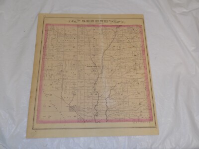
Free Shipping Location: Monroeville, United States Click Here. Double your traffic. Get Vendio Gallery- Now FREE! The conditon on this 1875 antique map is amazing. Vintage antique 1874 handcolored map. ... moreThe map is 2 sided and either side would frame and display nicely. One side is Map of Gustavus Township. I see Gustavus Center, Harts Corners, and much more. The map is in superb condition. Verso is a superb antique lithograph print page, showing 2 superb views at Fowler Township, both have horse drawn carriages in the views. This is an antique map and not a reprint or reproduction. The handcoloring on the map is period to the map, this is before color printing. The last page is a fine lithograph print showing 6 fine views, Res of Nl Gates, Farmington Twp, Western Reserve Seminary, West Farmington, Res of George Stone, Gustavus Twp, Res of RR Bascom, Greene Twp, Tes of AA House, Bristol Twp, Res of LC Perkins, Kinsman, Kinsman Twp. The map is from the very rare 1875 Everts Atlas of Trumbull County Ohio. The map is a fascinating and historic period look at this area at this time. The map shows the home and land owners, the business and industry, the few roads, railroads etc that existed at that time. The photo wont show the full beauty of the map. The map is in nice shape,tight and clean. The size of the map is 14" by 17" Winning bidder pays $4.00 shipping domestic, more foreign. Payment I accept the following forms of payment: PayPal Click to View Image Album Click to View Image Album Shipping& Handling US Shipping. $4.00 USPS First-Class Mail® International Shipping. $11.50 USPS First-Class Mail International FREE scheduling. Supersized images and templates. Get Vendio Sales Manager. FREE scheduling. Supersized images and templates. Get Vendio Sales Manager. RcmdId ViewItemDescV4,RlogId p4%60bo7%60jtb9%3Fuk%601d72f%2Bfg2%3E-14b5654c2e1-0x111-
Buy It Now
Free Shipping Location: Monroeville, United States Source - Combination Atlas Map of Trumbull County, Ohio. Date - 1874.
Buy It Now
Free Shipping Location: Monroeville, United States Source - Combination Atlas Map of Trumbull County, Ohio. Date - 1874.

Buy It Now
$4.00 Shipping Location: Winter Springs, United States Click Here. Double your traffic. Get Vendio Gallery- Now FREE! Vintage antique 1874 handcolored map. The map is 2 sided and either side would frame and ... moredisplay nicely. One side is Map of Greene Township. I see Greensburg and much more. Verso is a superb antique lithograph print page, showing 2 superb views at Fowler Township, both have horse drawn carriages in the views, top view is Res of John Jones, and bottom is Res of Tp Craft. This is an antique map and not a reprint or reproduction. The handcoloring on the map is period to the map, this is before color printing. The last page is a fine lithograph print showing a view of Res. of G.E. Shank. The map is from the very rare 1875 Everts Atlas of Trumbull County Ohio. The map is a fascinating and historic period look at this area at this time. The map shows the home and land owners, the business and industry, the few roads, railroads etc that existed at that time. The photo wont show the full beauty of the map. The map is in nice shape,tight and clean. The size of the map is 14" by 17" Winning bidder pays $4.00 shipping domestic, more foreign. Payment I accept the following forms of payment: PayPal Click to View Image Album Click to View Image Album Shipping& Handling US Shipping. $3.75 USPS First-Class Mail® International Shipping. $11.50 USPS First-Class Mail International FREE scheduling. Supersized images and templates. Get Vendio Sales Manager. FREE scheduling. Supersized images and templates. Get Vendio Sales Manager. RcmdId ViewItemDescV4,RlogId p4%60bo7%60jtb9%3Fuk.rp*a4%601gc%3E-14706552125-0x10f-
Buy It Now
$4.00 Shipping Location: Columbus, United States This map is in Very Good condition, with nice bright color, but also with a few pinhole tears at the fold intersections. The map shows Warren, Niles, ... moreGirard, Newton Falls, and more. HOFFMAN BOOKS, ABAA, IOBA.
Buy It Now
Free Shipping Location: Monroeville, United States Source - Combination Atlas Map of Trumbull County, Ohio. Date - 1874.
Buy It Now
$10.75 Shipping Location: Kansas City, United States Dated 1907. Topographical Map of Ohio.
Buy It Now
$7.00 Shipping Location: Jacksonville, United States 1867 Town of Trumbull, Fairfield County Connecticut antique map with Nichol's Farms inset. A beautiful and colorful map from the F.W. Beers Atlas of New ... moreYork & Vicinity, published in 1867. Overall, good condition.
Buy It Now
$3.75 Shipping Location: Winter Springs, United States The condition on this 1874 antique map is amazing. This is an antique map and not a reprint or reproduction. The handcoloring on the map is period to ... morethe map, this is before color printing. The map is from the very rare 1875 Everts Atlas of Trumbull County Ohio.
Buy It Now
Free Shipping Location: Monroeville, United States Source - Combination Atlas Map of Trumbull County, Ohio. Date - 1874.

Buy It Now
Free Shipping Location: Monroeville, United States Click Here. Double your traffic. Get Vendio Gallery- Now FREE! The conditon on this 1875 antique map is amazing. Vintage antique 1874 handcolored map. ... moreThe map is 2 sided and either side would frame and display nicely. One side is Map of Weathersfield Township. I see Niles, Mineral Ridge and much more. The map is in superb condition. Verso is a superb antique lithograph print page, showing 2 superb views at Fowler Township, both have horse drawn carriages in the views. This is an antique map and not a reprint or reproduction. The handcoloring on the map is period to the map, this is before color printing. The last page is a fine lithograph print showing 6 fine views, Res of Benjamin Leach, Weathersfield Twp, Res of Mathew Ramsey, Weathersfield, Res of Thomas Campbell, Weathersfield Twp, Res of SH Stillwagon, Weathersfield Twp, bottom is Res of Hiram Ohl, Niles, and Res of SH Pew, Niles. The map is from the very rare 1875 Everts Atlas of Trumbull County Ohio. The map is a fascinating and historic period look at this area at this time. The map shows the home and land owners, the business and industry, the few roads, railroads etc that existed at that time. The photo wont show the full beauty of the map. The map is in nice shape,tight and clean. The size of the map is 14" by 17" Winning bidder pays $4.00 shipping domestic, more foreign. Payment I accept the following forms of payment: PayPal Click to View Image Album Shipping& Handling US Shipping. $4.00 USPS First-Class Mail® International Shipping. $11.50 USPS First-Class Mail International FREE scheduling. Supersized images and templates. Get Vendio Sales Manager. FREE scheduling. Supersized images and templates. Get Vendio Sales Manager.
Buy It Now
Free Shipping Location: Monroeville, United States Source - Combination Atlas Map of Trumbull County, Ohio. Date - 1874.
Buy It Now
Free Shipping Location: Monroeville, United States Source - Combination Atlas Map of Trumbull County, Ohio. Date - 1874.

Buy It Now
$3.75 Shipping Location: Winter Springs, United States Click Here. Double your traffic. Get Vendio Gallery- Now FREE! Vintage antique 1875 handcolored map. The map is 2 sided and either side would frame and ... moredisplay nicely. One side is Map of Lordstown Township. I see many fascianting areas. The map shows the named home and land owners, the business and industry, the few roads, railroads etc that existed at that time. Verso is a superb lithograph print page, showing superb period views, they are Res of Aaron davis, bazetta Twp, Res of WW Post, Crotland, Bazetta Township, and Oakdale Farm, Bazetta Twp. This is an antique map and not a reprint or reproduction. The handcoloring on the map is period to the map, this is before color printing. The map is from the very rare 1875 Everts Atlas of Trumbull County Ohio. The map is a fascinating and historic period look at this area at this time. The photo wont show the full beauty of the map. The map is in nice shape,tight and clean. The size of the map is 14" by 17" Winning bidder pays $3.75 shipping domestic, more foreign. Payment I accept the following forms of payment: PayPal Click to View Image Album Click to View Image Album Shipping& Handling US Shipping. $3.75 USPS First-Class Mail® International Shipping. $11.50 USPS First-Class Mail International FREE scheduling. Supersized images and templates. Get Vendio Sales Manager. FREE scheduling. Supersized images and templates. Get Vendio Sales Manager.
Buy It Now
Free Shipping Location: Monroeville, United States Source - Combination Atlas Map of Trumbull County, Ohio. Date - 1874. Printed on Reverse - Sketches of 6 residences.

Buy It Now
Free Shipping Location: Monroeville, United States Click Here. Double your traffic. Get Vendio Gallery- Now FREE! The conditon on this 1875 antique map is amazing. Vintage antique 1874 handcolored map. ... moreThe map is 2 sided and either side would frame and display nicely. One side is Map of Bloomfield Township. I see North Bloomfield, North Bloomfield Station and more. Verso is a superb page of views all at Warren Ohio, businesses and so forth, City Mills, Furniture Rooms, and more. This is an antique map and not a reprint or reproduction. The handcoloring on the map is period to the map, this is before color printing. The map is from the very rare 1875 Everts Atlas of Trumbull County Ohio. The map is a fascinating and historic period look at this area at this time. The map shows the home and land owners, the business and industry, the few roads, railroads etc that existed at that time. The photo wont show the full beauty of the map. The map is in nice shape,tight and clean. The size of the map is 14" by 17" Winning bidder pays $4.00 shipping domestic, more foreign. Payment I accept the following forms of payment: PayPal Click to View Image Album Click to View Image Album Shipping& Handling US Shipping. $3.75 USPS First-Class Mail® International Shipping. $11.50 USPS First-Class Mail International FREE scheduling. Supersized images and templates. Get Vendio Sales Manager. FREE scheduling. Supersized images and templates. Get Vendio Sales Manager.

Buy It Now
$3.75 Shipping Location: Winter Springs, United States Click Here. Double your traffic. Get Vendio Gallery- Now FREE! The condition on this 1874 antique map is amazing. Vintage antique 1874 handcolored map. ... moreThe map is 2 sided and either side would frame and display nicely. One side is Map of Fowler Township. I see Fowler PO, and more. The map shows the named home and land owners, the business and industry, the few roads, railroads etc that existed at that time. Verso is a superb lithograph print page, with 2 Fowler Township views, they are Res of Mrs EV Kellogg, and Res of Archibald McFarland. This is an antique map and not a reprint or reproduction. The handcoloring on the map is period to the map, this is before color printing. The map is from the very rare 1875 Everts Atlas of Trumbull County Ohio. The map is a fascinating and historic period look at this area at this time. The photo wont show the full beauty of the map. The map is in nice shape,tight and clean. The size of the map is 14" by 17" Winning bidder pays $3.75 shipping domestic, more foreign. Payment I accept the following forms of payment: PayPal Click to View Image Album Click to View Image Album Shipping& Handling US Shipping. $3.75 USPS First-Class Mail® International Shipping. $11.50 USPS First-Class Mail International FREE scheduling. Supersized images and templates. Get Vendio Sales Manager. FREE scheduling. Supersized images and templates. Get Vendio Sales Manager.
Buy It Now
Free Shipping Location: Monroeville, United States Source - Combination Atlas Map of Trumbull County, Ohio. Date - 1874. Printed on Reverse - Sketches of 6 residences.
Buy It Now
Free Shipping Location: Monroeville, United States Date - 1874. Source - Combination Atlas Map of Trumbull County, Ohio. Size - about 13.75x16.5", hand-colored.

Buy It Now
$3.75 Shipping Location: Winter Springs, United States Click Here. Double your traffic. Get Vendio Gallery- Now FREE! The conditon on this 1875 antique map is amazing. Vintage antique 1875 handcolored map. ... moreThe map is 2 sided and either side would frame and display nicely. One side is Map of Brookfield Township. I see Brookfield Center PO, Paynes Corners PO, Walnut Hill and many fascinating areas, map has a clean tear at lower right, about 2.5" partially repaired on reverse with archival tape. reverse is a lithograph print page with 6 Johnston Township views, they are: res of J and R Johnston, Res of Rev Ozias Eells, Res of James Bradley, Res of Horace Cram, Res of EP Alling, res of Edwin Roberts. The map is a fascinating and historic period look at this area at this time. The map shows the home and land owners, the business and industry, the few roads, railroads etc that existed at that time. This is an antique map and not a reprint or reproduction. The handcoloring on the map is period to the map, this is before color printing. The map is from the very rare 1875 Everts Atlas of Trumbull County Ohio. The photo wont show the full beauty of the map. The map is in nice shape,tight and clean. The size of the map is 14" by 17" Winning bidder pays $4.00 shipping domestic, more foreign. Payment I accept the following forms of payment: PayPal Click to View Image Album Click to View Image Album Shipping& Handling US Shipping. $3.75 USPS First-Class Mail® International Shipping. $11.50 USPS First-Class Mail International FREE scheduling. Supersized images and templates. Get Vendio Sales Manager. FREE scheduling. Supersized images and templates. Get Vendio Sales Manager.
Buy It Now
$4.00 Shipping Location: United States This is an antique map and not a reprint or reproduction. The handcoloring on the map is period to the map, this is before color printing. The last page ... moreis a fine lithograph print showing 6 fine views, Res of Nl Gates, Farmington Twp, Western Reserve Seminary, West Farmington, Res of George Stone, Gustavus Twp, Res of RR Bascom, Greene Twp, Tes of AA House, Bristol Twp, Res of LC Perkins, Kinsman, Kinsman Twp.

Buy It Now
$3.75 Shipping Location: Winter Springs, United States Click Here. Double your traffic. Get Vendio Gallery- Now FREE! The conditon on this 1875 antique map is amazing. Vintage antique 1875 handcolored map. ... moreThe map is 4 pages and any side would frame and display beautfully. The first page is a fine lithograph print page, with Niles and Greene Township views, the next 2 pages is a huge map titled City Map of Niles. The map has a small piece issing at right, and a clean tear at lower left hand side, about 1" plus another at middle left, about 1" Overall in nice shape. The last page is all superb Niles views. The map shows the home and land owners, the business and industry, the few roads, railroads etc that existed at that time. Gorgeous, detailed period map. This is an antique map and not a reprint or reproduction. The handcoloring on the map is period to the map, this is before color printing. The map is from the very rare 1875 Everts Atlas of Trumbull County Ohio. The photo wont show the full beauty of the map. The map is in nice shape,tight and clean. The size of the print is 14" by 17" and the size of the map is 17" by 28" Winning bidder pays $4.00 shipping domestic, more foreign. Payment I accept the following forms of payment: PayPal Click to View Image Album Click to View Image Album Click to View Image Album Shipping& Handling US Shipping. $3.75 USPS First-Class Mail® International Shipping. $11.50 USPS First-Class Mail International FREE scheduling. Supersized images and templates. Get Vendio Sales Manager. FREE scheduling. Supersized images and templates. Get Vendio Sales Manager.
Buy It Now
Free Shipping Location: Monroeville, United States Size - about 17x21", double page as published, hand-colored. Source - Combination Atlas Map of Trumbull County, Ohio. Date - 1874.

Buy It Now
$3.75 Shipping Location: Winter Springs, United States Click Here. Double your traffic. Get Vendio Gallery- Now FREE! Vintage antique 1874 handcolored map. The map is 2 sided and either side would frame and ... moredisplay nicely. One side is Map of Greene Township. I see Greensburg and much more. Verso is a superb antique lithograph print page, showing 2 superb views at Fowler Township, both have horse drawn carriages in the views, top view is Res of John Jones, and bottom is Res of Tp Craft. This is an antique map and not a reprint or reproduction. The handcoloring on the map is period to the map, this is before color printing. The last page is a fine lithograph print showing a view of Res. of G.E. Shank. The map is from the very rare 1875 Everts Atlas of Trumbull County Ohio. The map is a fascinating and historic period look at this area at this time. The map shows the home and land owners, the business and industry, the few roads, railroads etc that existed at that time. The photo wont show the full beauty of the map. The map is in nice shape,tight and clean. The size of the map is 14" by 17" Winning bidder pays $4.00 shipping domestic, more foreign. Payment I accept the following forms of payment: PayPal Click to View Image Album Click to View Image Album Shipping& Handling US Shipping. $3.75 USPS First-Class Mail® International Shipping. $11.50 USPS First-Class Mail International FREE scheduling. Supersized images and templates. Get Vendio Sales Manager. FREE scheduling. Supersized images and templates. Get Vendio Sales Manager. RcmdId ViewItemDescV4,RlogId p4%60bo7%60jtb9%3Fuk.rp*a4%601gc%3E-14706552125-0x10f-
Buy It Now
$4.00 Shipping Location: Winter Springs, United States This is an antique map and not a reprint or reproduction. The handcoloring on the map is period to the map, this is before color printing. The map is ... morefrom the very rare 1874 Everts Atlas of Trumbull County Ohio.
Buy It Now
Free Shipping Location: Monroeville, United States Date - 1874. Source - Combination Atlas Map of Trumbull County, Ohio. Size - about 13.25x16.5", hand-colored.

Buy It Now
$4.00 Shipping Location: Winter Springs, United States Click Here. Double your traffic. Get Vendio Gallery- Now FREE! The conditon on this 1875 antique map is amazing. Vintage antique 1875 handcolored map. ... moreThe map is 2 sided and either side would frame and display nicely. One side is Map of Johnston Township. Reverse is Map of Vernon Township. The map is a fascinating and historic period look at this area at this time. The map shows the named home and land owners, the business and industry, the few roads, railroads etc that existed at that time. This is an antique map and not a reprint or reproduction. The handcoloring on the map is period to the map, this is before color printing. The map is from the very rare 1875 Everts Atlas of Trumbull County Ohio. The photo wont show the full beauty of the map. The map is in nice shape,tight and clean. The size of the map is 14" by 17" Winning bidder pays $4.00 shipping domestic, more foreign. Payment I accept the following forms of payment: PayPal Click to View Image Album Click to View Image Album Shipping& Handling US Shipping. $4.00 USPS First-Class Mail® International Shipping. $11.50 USPS First-Class Mail International FREE scheduling. Supersized images and templates. Get Vendio Sales Manager. FREE scheduling. Supersized images and templates. Get Vendio Sales Manager.
Buy It Now
Free Shipping Location: Monroeville, United States County - Trumbull. Date - 1907, reprint of 1920, survey of 1905. Condition - Very Nice, code number written lower right corner. State - Ohio. Bodies of ... moreWater - Eagle Creek, Grand River, Mosquito Creek.
Buy It Now
$3.75 Shipping Location: Winter Springs, United States The conditon on this 1874 antique map is amazing. This is an antique map and not a reprint or reproduction. The handcoloring on the map is period to the ... moremap, this is before color printing. The map is from the very rare 1874 Everts Atlas of Trumbull County Ohio.
Buy It Now
Free Shipping Location: Monroeville, United States Date - 1874. Source - Combination Atlas Map of Trumbull County, Ohio. Size - about 13.75x16.75", hand-colored.
Buy It Now
Free Shipping Location: Monroeville, United States Source - Combination Atlas Map of Trumbull County, Ohio. Date - 1874. Size - about 13.5x16.25", hand-colored.
Buy It Now
$6.80 Shipping Location: Eagle, United States Presented is an authentic, old map taken from a dis-bound plat book published in 1905. Original color. Map is age toned with an occasional fox spot.
Buy It Now
Free Shipping Location: Tempe, United States These are all full color with profile and legend color blocks. They from different states and different sizes. Dates range from 1909-1914. Most are very ... moregood. Clinton NY map has many splits along the folds.

Buy It Now
$5.00 Shipping Location: Monroeville, United States This item is a 15-minute topographical map of the Warren Quadrangle. OH Date of Map- Edition of 1908. Reprint of 1937, survey 1906 Principal Town(s) Warren ... moreand Niles. Trumbull County, OH Area Covered- Parts of Trumbull and Mahoning Counties. OH Size(approx. 16.5x20" Other Towns- Newton Falls. Leavittsburg, Lordstown, West Austintown, Smith Corners, Canfield, Ellsworth, Berlin Center, and more Features very early 1900s road system and geographical features for this area. On the back is a summary of the topo map program. And an illustration of"Conventional Signs" Polyconic projection, North American Datum. Very nice condition. Yes! We Do Combine Shipping on Multiple Purchases! NO RESERVE! Happy Bidding! Buyer pays $5.00 for shipping/packing in the U.S. includes APO addresses) We use very secure packaging methods and materials. And all shipments within the United States will be made with the protection of the new USPS Parcel shipping category. First Class or Priority. Depending on weight) Note that certain items may be shipped in the USPS Media Mail category. If appropriate. Payment due within 14 days after our initial after auction contact. Pennsylvania residents MUST add applicable SALES TAX or send resale number. International shipping is more. Send address for quote. International payments must be through Paypal.com. Thanks. Good Luck! To See Our Other Auctions and Store Items CLICK HERE! Created by eBay Blackthorne ver. 3.2.31.0 Powered by The free listing tool. List your items fast and easy and manage your active items.

Buy It Now
$3.75 Shipping Location: Winter Springs, United States Click Here. Double your traffic. Get Vendio Gallery- Now FREE! Vintage antique 1874 handcolored map. The map is 2 sided and either side would frame and ... moredisplay nicely. One side is Map of Newton Township. I see Newton and more.The map shows the home and land owners, the business and industry, the few roads, railroads etc that existed at that time. Verso is a superb lithograph print page, showing 5 superb views at Gustavus Township, and 1 at east Messa. This is an antique map and not a reprint or reproduction. The handcoloring on the map is period to the map, this is before color printing. The map is from the very rare 1875 Everts Atlas of Trumbull County Ohio. The map is a fascinating and historic period look at this area at this time. The photo wont show the full beauty of the map. The map is in nice shape,tight and clean. The size of the map is 14" by 17" Winning bidder pays $3.75 shipping domestic, more foreign. Payment I accept the following forms of payment: PayPal, Preferred Checkout For fastest processing of this order. Please use Vendio Checkout! Click to View Image Album Click to View Image Album Shipping& Handling $3.75 USPS First-Class Mail® FREE scheduling. Supersized images and templates. Get Vendio Sales Manager. FREE scheduling. Supersized images and templates. Get Vendio Sales Manager. Win more auctions at the last minute FREE. Learn how.

Buy It Now
$5.00 Shipping Location: Monroeville, United States This item is a 15-minute topographical map of the Bristolville Quadrangle. Trumbull County, OH Date of Map- Edition of 1907. Reprinted 1920, surveyed ... more1905 Principal Town(s) Delightful. Trumbull County, OH Area Covered- Part of Trumbull County. OH Size(approx. 16.5x20" Other Towns- Mesopotamia. North Bloomfield, Greene, West Mecca, Spokane, Bristolville, Farmington, and more Features very early 1900s road system and geographical features for this area. On the back is a summary of the topo map program. And an illustration of"Conventional Signs" Polyconic projection, North American Datum. Very nice condition. Yes! We Do Combine Shipping on Multiple Purchases! NO RESERVE! Happy Bidding! Buyer pays $5.00 for shipping/packing in the U.S. includes APO addresses) We use very secure packaging methods and materials. And all shipments within the United States will be made with the protection of the new USPS Parcel shipping category. First Class or Priority. Depending on weight) Note that certain items may be shipped in the USPS Media Mail category. If appropriate. Payment due within 14 days after our initial after auction contact. Pennsylvania residents MUST add applicable SALES TAX or send resale number. International shipping is more. Send address for quote. International payments must be through Paypal.com. Thanks. Good Luck! To See Our Other Auctions and Store Items CLICK HERE! Created by eBay Blackthorne ver. 3.2.31.0 Powered by The free listing tool. List your items fast and easy and manage your active items. RcmdId ViewItemDescV4,RlogId p4%60bo7%60jtb9%3Fuk.rp*a4%601gc%3E-14706552115-0x104-
Buy It Now
$12.85 Shipping Location: Floral Park, United States This is a 24x36 high quality, high resolution reproduction on 70 lb. It is in Mint condition.
Buy It Now
$12.85 Shipping Location: Floral Park, United States This is an original 1888 Bridgeport, Connecticut P lat Atlas Map.
Buy It Now
$12.85 Shipping Location: Floral Park, United States This is an original 1888 New Haven, Connecticut G.M. Hopkins Plat Atlas Map that includes Hillhouse Mansion and Historic District, Yale University and ... moreother noteworthy buildings and structures.
Buy It Now
$12.85 Shipping Location: Floral Park, United States This is an original 1888 North Bridgeport, Connecticut P lat Atlas Map.
Buy It Now
$12.85 Shipping Location: Floral Park, United States Condition: EX 23x32! Dated in Right Hand Corner.
Buy It Now
$12.85 Shipping Location: Floral Park, United States This is an original 1929 Bridgeport, Connecticut G.M. Hopkins Pl at Atlas Map that includes Reservoir Whiskey Hill Park, Hallen School a nd other noteworthy ... morebuildings and structures.
Buy It Now
$12.85 Shipping Location: Floral Park, United States
|
|
|
In
|
SUPERB ANTIQUE 1875 CHAMPION LORDSTOWN TOWNSHIP TRUMBULL COUNTY OHIO MAP PRINT N
Click Here. Double your traffic. Get Vendio Gallery- Now FREE! Vintage antique 1875 handcolored map. The map is 2 sided and either side would frame and display nicely. One side is Map of Champion Township. I see Trumbull County Infirmary Farm, and many fascianting areas. The map shows the named home and land owners, the business and industry, the few roads, railroads etc that existed at that time. Verso is a superb lithograph print page, showing superb period views, all are Lordstown Township views, and 1 Kinsman Twp, they are: Res of John Pew, res of John McKee, Res of major Andrew Grove, res of JB Jordan, Res of James Wilson and Res of James Scott, the last is Kinsman Twp. This is an antique map and not a reprint or reproduction. The handcoloring on the map is period to the map, this is before color printing. The map is from the very rare ... more1875 Everts Atlas of Trumbull County Ohio. The map is a fascinating and historic period look at this area at this time. The photo wont show the full beauty of the map. The map is in nice shape,tight and clean. The size of the map is 14" by 17" Winning bidder pays $4.00 shipping domestic, more foreign. Payment I accept the following forms of payment: PayPal Click to View Image Album Click to View Image Album Shipping& Handling US Shipping. $4.00 USPS First-Class Mail® International Shipping. $11.50 USPS First-Class Mail International FREE scheduling. Supersized images and templates. Get Vendio Sales Manager. FREE scheduling. Supersized images and templates. Get Vendio Sales Manager.
|
|
 |