-
Christian Collectibles
-
Christian Sheet Music
-
Vatican Stamps
-
Vatican Coins & Paper Money
-
Antiques
-
Antiquities
-
Architectural & Garden
-
Decorative Arts
-
Ethnographic
-
Furniture
-
Maps, Atlases & Globes
-
United States (Pre-1900)
-
AK, HI
-
AL, FL, GA, MS, NC, SC
-
AR, IA, KS, LA, MO, NE
-
AZ, CA, CO, NM, NV, UT
-
CT, MA, ME, NH, RI, VT
-
DC, DE, MD, NJ, NY, PA
-
ID, OR, WA
-
IL, IN, MI, OH, WI
-
MN, MT, ND, SD, WY
-
OK, TX
-
VA, WV, KY, TN
-
Entire US
-
United States (1900-Now)
-
United States (Date Unknown)
-
Africa
-
Asia
-
Australasia/ Oceania
-
Canada
-
Central America/ Caribbean
-
Europe
-
India
-
Ireland
-
Mexico
-
Middle East
-
North America
-
South America
-
United Kingdom
-
Maps on CD
-
World Maps
-
Globes
-
Mixed Lots
-
Reproductions
-
Price Guides & Publications
-
Other
|
In
Order by: Available to: This site contains affiliate links for which I may be compensated
|
Buy It Now
$3.95 Shipping Location: Clarkston, United States Jackson County Atlas. This DVD is part of our Historic Atlas Collection. Title of this Atlas mo404 Outline map of Jackson County. mo405 Outline map of ... moreJackson County - color. mo4049 Patrons' Directory of Jackson County, Missouri.
Buy It Now
Free Shipping Location: Monroe, United States MAP HAS LIST AT SIDES OF CHIEF CITIES AND POPULATION INFORMATION. DATE 1895, AT BOTTOM. GOOD -FAIR CONDITION, DISCOLORATION, MAP ON REVERSE.
Buy It Now
Free Shipping Location: Monroe, United States ORIGINAL ANTIQUE 1916 COLOR MAP OF THESTATE OF MISSISSIPPI. MAP HAS A SCALE BELOW TITLE. DATE - 1916, NOT ON MAP. MAP IS BEAUTIFULLY COLORED AND VERY ... moreDETAILED.
Buy It Now
$7.00 Shipping Location: Rockville, United States This map is from the "ATLAS OF SUSQUEHANA CO. FROM ACTUAL SURVEYS BY AND UNDER THE DIRECTION OF F.W. BEERS. Engravings on stone by Louis E. Neuman. Power ... morePress Print of Charles Hart. It is blank on the reverse side.
Buy It Now
Free Shipping Location: Monroeville, United States Date - 1873.
Buy It Now
$6.00 Shipping Location: Corunna, United States A. Ogle & Co. Chicago in 1911. This is an original 112 year old map, not a copy or reprint.
Buy It Now
$6.00 Shipping Location: Corunna, United States This plat map is from a 1909 Standard Atlas of Riley County Kansas including plat book published by Geo. A. Ogle & Co. This is an original 115 year old ... moremap, not a copy or reprint.
Buy It Now
Free Shipping Location: Monroeville, United States Date - 1866. Source - Atlas of Muskingum County, Ohio. Condition - Quite nice, a stain in upper right blank border corner.
Buy It Now
$6.00 Shipping Location: Corunna, United States This plat map is from a Elkhart County Indiana plat book published by Geo. A. Ogle & Co. in 1892. This is an original 130 year old map, not a copy or ... morereprint.
Buy It Now
Free Shipping Location: Monroeville, United States Date - 1876. Source - Illustrated Atlas of Noble County, Ohio. Size - about - 13.75x17.5", hand-colored.
Buy It Now
Free Shipping Location: Monroeville, United States Source - An Atlas of Van Wert County, Ohio. Date - 1886.
Buy It Now
Free Shipping Location: Monroeville, United States Source - Atlas of Preble County, Ohio. Date - 1871. Size - about 12x15", hand-colored.
Buy It Now
$14.05 Shipping Location: Freehold, United States Kingman Brothers. Dated 1877. Title of Book was Combination Atlas of Howard County Indiana.
Buy It Now
$3.95 Shipping Location: Clarkston, United States This DVD is part of our Historic Atlas Collection. Dearborn County, Indiana. Title of this Atlas to which is added a map of the state of Indiana. dearborn000036--List ... moreof Patrons for the Atlas of Dearborn County.
Buy It Now
Free Shipping Location: Monroe, United States MAP HAS SCALE BELOW TITLE AT BOTTOM WITH POPULATION AND AREA IN SQUARE MILES. LAST PICTURE IS THE TITLE PAGE FROM THE ATLAS WHICH THIS MAP WAS REMOVED ... moreFROM, NOT INCLUDED. DATE-1889, NOT ON MAP.
Buy It Now
$4.87 Shipping Location: Quincy, United States Iowa state ~ Lee County ~ Des Moines Township & Jackson Township. 9 Maps Lot. 36x24 size. Normal wear on edges, see pictures. Says Rathburn Regional Assn. ... moreInc. And 8 of the maps indicate T65N, R6W. Shipped with USPS. More pictures are available upon request. Maps are used and are being sold as is. Thanks for looking. Be sure to view my other auctions, lots of variety and even some unique items too. I offer combined shippimg. So the more you buy, the more you save.
Buy It Now
$6.00 Shipping Location: Corunna, United States A. Ogle & Co. Chicago in 1911. This is an original 112 year old map, not a copy or reprint.
Buy It Now
$6.00 Shipping Location: Corunna, United States A. Ogle & Co. Chicago in 1911. This is an original 112 year old map, not a copy or reprint.
Buy It Now
$6.00 Shipping Location: Corunna, United States A. Ogle & Co. Chicago in 1911. This is an original 112 year old map, not a copy or reprint.
Buy It Now
$6.00 Shipping Location: Corunna, United States A. Ogle & Co. Chicago in 1911. This is an original 112 year old map, not a copy or reprint.
Buy It Now
$6.00 Shipping Location: Corunna, United States This map is from a Standard Atlas of Elkhart County Indiana published in 1915 by Geo. Title page in photos is not included in sale, It is shown for authentication ... morepurposes only.
Buy It Now
$6.00 Shipping Location: Corunna, United States A. Ogle & Co. Chicago in 1911. This is an original 112 year old map, not a copy or reprint.
Buy It Now
$6.80 Shipping Location: Las Vegas, United States Otherwise in great antique condition. No pin holes in corners, No writing.
Buy It Now
$6.00 Shipping Location: Corunna, United States A. Ogle & Co. Chicago in 1911. This is an original 112 year old map, not a copy or reprint.
Buy It Now
Free Shipping Location: Kennebunk, United States This Map was removed from a 1896 Atlas and is in good acceptable condition. Only Authentic Originals. Study the photos carefully, this is the actual map ... moreyou.
Buy It Now
$3.75 Shipping Location: Winter Springs, United States Nice outside ornate border as well. The map is printed on thick paper. This is an antique map and not a reprint or reproduction. The handcoloring on the ... moremap is period to the map, this is before color printing.
Buy It Now
$6.00 Shipping Location: Corunna, United States A. Ogle & Co. Chicago in 1911. This is an original 112 year old map, not a copy or reprint.
Buy It Now
Free Shipping Location: Schertz, United States This Map was removed from a 1877 HOWARD COUNTY, INDIANA Plat Atlas and is in good condition. The map is not " new " or in " new " condition, it was printed ... morein 1877. The map is not dated. (NOTE SHADOW, OLD SQUARE STAIN & THE ACTUAL COLOR OF THE MAP IS MUCH LIGHTER THAN THE PHOTOS INDICATE, MORE TAN THAN PINK ).
Buy It Now
$3.95 Shipping Location: Clarkston, United States Crawford County, Iowa. Crawford01 Cover Crawford02 Standard Atlas of Crawford County, Iowa - Title Page. This DVD is part of our Historic Atlas Collection. ... moreTitle of this Atlas Standard Atlas of. Crawford36 Patron's Reference Directory Crawford37 Patron's Reference Directory continued.
Buy It Now
$100.00 Shipping Location: Boonville, United States In fact, 100% of all proceeds go directly to the Stoney Shire, allowing us to create and grow the Community and it's platform. The Stoney Shire can b ... morering to you. ^ Use this URL Code to See More From Your Friends at the Shire ^.

Buy It Now
$3.95 Shipping Location: Clarkston, United States Rare Map Collection This DVD is part of our Historic Map and Atlas Collection. We have dozens of Atlas maps on DVD and CD ranging from the 1500s to the ... more1900s covering many areas and topics. Please Check our Ebay Store for what's available. FOR MANY MORE EDUCATIONAL CD TITLES ON THIS AND MANY OTHER SUBJECTS PLEASE VISIT OUR EBAY STORE VERY LARGE HIGH RESOLUTION MAP COLLECTION ON DVD! please see full table of contents and sample illustrations below) This DVD Contains 234 Maps of Michigan Including 45 PANORAMIC MAPS of various Iowa Cities These are scans of the ORIGINAL maps by various Cartographers. on DVD System requirements PC or Mac compatible. Files are simple PDF files with a basic HTML interface(just like viewing a webpage) Works with ALL versions of Windows. Maps of Michigan Map of Michigan showing the Toledo. Ann Arbor, North Michigan Railway and connecting lines. 1886, Map of the northwestern states. Shewing[sic] what proportion lies north of the parallel of South Bend of Lake Michigan. It will be seen at a glance. That the unbroken line of communication with the Atlantic seaboard, and the only winter route for northern Indiana, northern Illinois, Michigan, Iowa, Wisconsin, and Minnesota, will be by the Michigan Southern Railway, and south shore of Lake Erie. 1850, Railroad map of Michigan prepared for the commissioner of railroads. c1874, Skeleton map. Showing the position and connections of the Michigan Southern Rail Road(from Toledo to Chicago) with the several great rail road routes to the Atlantic seaboard and New York City via the south shore of Lake Erie. 1850, Official map of Michigan. Railroad, township and sectional, prepared under the direction of the commissioner of railroads. 1855, A map of part of the continent of North America: between the 35th and 51st degrees of north latitude. And extending from 890 degrees of west longitude to the Pacific Ocean/ compiled from the authorities of the best informed travellers by M. Lewis; copied by Nicholas King, 1805. Carte de la riviere Longue
Buy It Now
$14.99 Shipping Location: Ivanhoe, Australia A gold rush began in Australia in the early 1850s, which boosted the population of the country. Indigenous Australian rock art is the oldest and richest ... morein the world, dating as far back as 60,000 years and spread across hundreds of thousands of sites.
Buy It Now
$3.75 Shipping Location: Winter Springs, United States This is an antique map and not a reprint. The conditon of the map is excellent, just amazing condition. The superb handcoloring on the map is period to ... morethe map, this is before color printing. The map is printed on thick paper.
Buy It Now
$6.00 Shipping Location: Corunna, United States A. Ogle & Co. Chicago in 1911. This is an original 112 year old map, not a copy or reprint.
Buy It Now
Free Shipping Location: Schertz, United States This Map was removed from an 1870 CLERMONT Co., OH Plat Atlas and is in good acceptable condition. The map is not " new " or in " new " condition, it ... morewas printed in 1870. The map is not dated. Study the photos carefully, this is the actual map you will receive.
Buy It Now
Free Shipping Location: Monroeville, United States Date - 1875. Size - about 13.75x15.75", hand-colored.
Buy It Now
$3.75 Shipping Location: United States The map is titled Jackson, Huntingdon Co. Great period map of this area. This is an antique map and not a reprint or reproduction. The handcoloring on ... morethe map is period to the map, this is before color printing.
Buy It Now
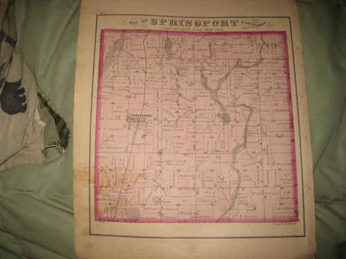
$4.00 Shipping Location: Winter Springs, United States Click Here. Double your traffic. Get Vendio Gallery- Now FREE! Vintage antique 1874 handcolored map. The map is 2 sided and either side would frame and ... moredisplay nicely. One side is titled Map of Springport Township. Beautiful period map. I see many fascianting areas, including Springport Po. The map shows the home and land owners, the business and industry, the few roads, railroads etc that existed at that time. Verso is 6 fine views, printed in a lithographic format, Res of AM Pardee, Spring Arbor Twp, Res of Geo. Hatch, Spring Arbor Twp, Spring Arbor Seminary, Spring Arbor Village, Res of Bc Hatch, Spring Arbor Twp, Res of SH Ludlow, Springport Twp, and Res of Geo. Landon, Springport Twp. This is an antique map and not a reprint or reproduction. The handcoloring on the map is period to the map, this is before color printing. The map is from the very rare 1874 Everts and Stewart Atlas of Jackson County Michigan. The map is a fascinating and historic period look at this area at this time. The size of the single map is 14" by 17" Rare. Winning bidder pays $4.00 shipping domestic, more foreign. Payment I accept the following forms of payment: PayPal Click to View Image Album Click to View Image Album Shipping& Handling US Shipping. $4.00 USPS First-Class Mail® International Shipping. $11.50 USPS First-Class Mail International FREE scheduling. Supersized images and templates. Get Vendio Sales Manager. FREE scheduling. Supersized images and templates. Get Vendio Sales Manager. 6gf1.RcmdId ViewItemDescV4,RlogId p4%60bo7%60jtb9%3Fuk.rp*2%60%3E6gf1-13dd8c55611-0xf8-
Buy It Now
$14.99 Shipping Location: Ivanhoe, Australia Handtke, Friedrich 1815 - 1879. - Hand Atlas of the Prussian State Flemming, Glogau 1846. - Royal Prussian Card. Province of Saxony, the duchy of Anhalt, ... morethe ducal. Saxon countries Weimar, Altenburg u. Gotha and the principals Schwarzburg and Reuss, Flemming, Glogau 1870/71.
Buy It Now
$14.99 Shipping Location: Ivanhoe, Australia He had three brothers, Louis-Henri de Saulces de Freycinet, André-Charles de Saulces de Freycinet and the youngest, Frédéric-Casimir de Saulces de Freycinet ... more(father of Charles de Freycinet). In 1793 he entered the French navy.
Buy It Now
Free Shipping Location: Monroeville, United States Date - 1870. Condition - Very Nice. Size - about 12x14.75", hand-colored.
Buy It Now
$6.00 Shipping Location: Corunna, United States A. Ogle & Co. Chicago in 1911. This is an original 112 year old map, not a copy or reprint.
Buy It Now
$6.00 Shipping Location: Corunna, United States A. Ogle & Co. Chicago in 1911. This is an original 112 year old map, not a copy or reprint.

Buy It Now
$3.75 Shipping Location: Winter Springs, United States Click Here. Double your traffic. Get Vendio Gallery- Now FREE! Vintage antique 1874 handcolored map. The map is titled. In fancy antique lettering, Jackson, ... morethis is Jackson Township. I see Polk, Perrysville and much more. The map shows the named land and home owners, named business and industry, named railroads, locatuions of buildings, and much more. The map is printed on thick paper, with no printing on reverse. The condition of the map is nice, with a stain at extreme right hand side, if framed would be covered. This is an antique map and not a reprint or reproduction. The handcoloring on the map is period to the map, this is before color printing, the map is printed on thick paper, with no printing on reverse. The map is from the very rare 1874 J.A. Caldwell Atlas of Ashland County Ohio. The map is a fascinating and historic period look at this area at this time. The photo wont show the full beauty of the map. The size of the map is 14" by 17" Winning bidder pays $3.75 shipping domestic, more foreign. Payment I accept the following forms of payment: PayPal Click to View Image Album Shipping& Handling US Shipping. $3.75 USPS First-Class Mail® International Shipping. $11.50 USPS First-Class Mail International FREE scheduling. Supersized images and templates. Get Vendio Sales Manager. FREE scheduling. Supersized images and templates. Get Vendio Sales Manager.
Buy It Now
Free Shipping Location: Schertz, United States This Map was removed from a 1870 HANCOCK COUNTY, OHIO Plat Atlas and is in good / fair condition. The map is not " new " or in " new " condition, it was ... moreprinted in 1875. Study the photos carefully, this is the actual map you will receive.
Buy It Now
$3.75 Shipping Location: Winter Springs, United States Beautiful map. The condition of the map is amazing. printed on thick paper, with no printing on reverse. This is an antique map and not a reprint or reproduction. ... moreThe handcoloring on the map is period to the map, this is before color printing.
Buy It Now
Free Shipping Location: Schertz, United States This antique original plat atlas map depicts Jackson Township, Ashland County, Ohio in the year 1874. Lithography was used for printing and it measures ... moreapproximately 14"x17". The map is published by J.A. Caldwell and is in good condition for its age. The map page is a valuable addition to any North America maps, maps, atlases & globes or antique collections. Free shipping and handling is available within the USA, while calculated shipping and handling charges apply for worldwide delivery.
Buy It Now
$4.00 Shipping Location: Winter Springs, United States ANY UNUSUAL SHADOWS OR FUZZINESS IS ON THE PHOTO ONLY. This is the finest antique map of this area I've ever seen. The conditon is superb. Fascianting ... moreperiod map of this area. This is an antique map and not a reprint or reproduction.
Buy It Now
$3.75 Shipping Location: Winter Springs, United States Beautiful map. The condition of the map is amazing. This is an antique map and not a reprint or reproduction. The handcoloring on the map is period to ... morethe map, this is before color printing. The map is from the very rare 1874 Titus, Simmon and Titus Atlas of Mahoning County Ohio.
Buy It Now
$6.00 Shipping Location: Corunna, United States A. Ogle & Co. Chicago in 1911. This is an original 112 year old map, not a copy or reprint.
Buy It Now
$3.75 Shipping Location: Winter Springs, United States This is an antique map and not a reprint. The conditon of the map is excellent, just amazing condition. The superb handcoloring on the map is period to ... morethe map, this is before color printing. I see Polkville PO and more.
Buy It Now
$3.75 Shipping Location: Winter Springs, United States The map is very finely printed on thick paper. This is an antique map and not a reprint or reproduction. The handcoloring on the map is period to the ... moremap, this is before color printing. The map is from the very rare 1876 Kingsman Bros.
Buy It Now
$15.45 Shipping Location: Harrisburg, United States A beautiful and well-preserved piece of local Pennsylvania history, showcasing the area in the latter half of the 19th Century.
Buy It Now
$6.80 Shipping Location: Eagle, United States Presented is an authentic old map taken from a dis-bound atlas published in 1924. Map reverses to advertising.
Buy It Now
$6.80 Shipping Location: Eagle, United States Presented is an authentic old map taken from a dis-bound plat book published in 1923.
Buy It Now
$6.80 Shipping Location: Eagle, United States Presented is an authentic old map taken from a dis-bound plat book published in 1911.
Buy It Now
$15.45 Shipping Location: Harrisburg, United States A beautiful and well-preserved piece of local Pennsylvania history, showcasing the area in the latter half of the 19th Century.

Buy It Now
$4.00 Shipping Location: Winter Springs, United States Click Here. Double your traffic. Get Vendio Gallery- Now FREE! Vintage fine antique 1894 handcolored map. The map is 2 sided and either side would frame ... moreand display beautifully. One side is Springport Township, I see Springport and much more, reverse is Norvell, Norvell Township. Each side has a light rubber stamp on it. The maps are very detailed, with the named home and land owners, cities, towns, locations of buildings, size of land parcels, named railroads, named lakes and much more of this period. The condition of the map is excellent. The map is from the rare 1894 American Atlas Company Atlas of Jackson County Michigan. This is an antique map and not a reprint or reproduction, fine period handcoloring. The map is a fascinating and historic period look at this area at this time. The photo wont show the full beauty of the map. The size of the map is 15.5" by 17.5" Winning bidder pays $4.00 shipping domestic, more foreign. Please see my eBay store for other rare maps for sale, at very reasonable prices. Payment I accept the following forms of payment: PayPal Click to View Image Album Click to View Image Album Shipping& Handling US Shipping. $4.00 USPS First-Class Mail® International Shipping. $11.50 USPS First-Class Mail International FREE scheduling. Supersized images and templates. Get Vendio Sales Manager. FREE scheduling. Supersized images and templates. Get Vendio Sales Manager.
Buy It Now
$14.99 Shipping Location: Ivanhoe, Australia Dower is the heir to the more prominent London engraver and mapmaker John Crane Dower. He was elected to the Royal Geographical Society in 1854. This ... moreoriginal hand coloured copper-plate engraved antique map of Australia, New Holland, was drawn & engraved by John Dower and published by Orr & Smith, in the 1835 edition ofNew General Atlas.
Buy It Now
$14.99 Shipping Location: Ivanhoe, Australia Handtke, Friedrich 1815 - 1879. - Hand Atlas of the Prussian State Flemming, Glogau 1846. - Royal Prussian Card. Province of Saxony, the duchy of Anhalt, ... morethe ducal. Saxon countries Weimar, Altenburg u. Gotha and the principals Schwarzburg and Reuss, Flemming, Glogau 1870/71.
|
|
|
In
|
JACKSON TOWNSHIP RR'S OHIO GUERNSEY COUNTY ATLAS MAP BY CARSON DAVIS
I DO COMBINE SHIPPING ON MULTIPLE PURCHASES TITLE JACKSON DATE 1914 ISSUED BY CARSON B DAVIS THIS AUCTION IS FOR AN ORIGINAL ATLAS MAP FROM THE ATLAS OF GUERNSEY COUNTY OHIO DATED 1914 BY CARSON B DAVIS SHOWING TOWNSHIP OF JACKSON WITH PROPERTY OWNER NAMES AND ALL RAILROAD ROUTES CONDITION FAIR. HAS STAINING AND TONING MEASURES 16 X 13 INCHES
|
|
|
HUNTINGTON COUNTY INDIANA 1879 PLAT MAP JACKSON TOWNSHIP
Huntington County Indiana 1879-copy of the Jackson Township- size is 10x 14-nice to frame or just for research
|
|
|
ANTIQUE 1894 SUMMIT BLACKMAN TOWNSHIP JACKSON CITY COUNTY MICHIGAN MAP RARE NR
Click Here. Double your traffic. Get Vendio Gallery- Now FREE! Vintage fine antique 1894 handcolored map. The map is 2 sided and either side would frame and display beautifully. The map has some wear at outside edges, and has a ligth rubber stamp on each side, but still in decent shape. One side is Blackman Township, I see Jackson and much more, reverse is Map of Summit Township, I see Jackson and more. The maps are very detailed, with the named home and land owners, cities, towns, locations of buildings, size of land parcels, named railroads, named lakes and much more of this period. The map is from the rare 1894 American Atlas Company Atlas of Jackson County Michigan. This is an antique map and not a reprint or reproduction, fine period handcoloring. The map is a fascinating and historic period look at this area at this time. The photo ... morewont show the full beauty of the map. The size of the map is 15.5" by 17.5" Winning bidder pays $4.00 shipping domestic, more foreign. Please see my eBay store for other rare maps for sale, at very reasonable prices. Payment I accept the following forms of payment: PayPal Click to View Image Album Click to View Image Album Shipping& Handling US Shipping. $4.00 USPS First-Class Mail® International Shipping. $11.50 USPS First-Class Mail International FREE scheduling. Supersized images and templates. Get Vendio Sales Manager. FREE scheduling. Supersized images and templates. Get Vendio Sales Manager.
|
|
 |