-
Christian Collectibles
-
Christian Sheet Music
-
Vatican Stamps
-
Vatican Coins & Paper Money
-
Antiques
-
Antiquities
-
Architectural & Garden
-
Decorative Arts
-
Ethnographic
-
Furniture
-
Maps, Atlases & Globes
-
United States (Pre-1900)
-
AK, HI
-
AL, FL, GA, MS, NC, SC
-
AR, IA, KS, LA, MO, NE
-
AZ, CA, CO, NM, NV, UT
-
CT, MA, ME, NH, RI, VT
-
DC, DE, MD, NJ, NY, PA
-
ID, OR, WA
-
IL, IN, MI, OH, WI
-
MN, MT, ND, SD, WY
-
OK, TX
-
VA, WV, KY, TN
-
Entire US
-
United States (1900-Now)
-
United States (Date Unknown)
-
Africa
-
Asia
-
Australasia/ Oceania
-
Canada
-
Central America/ Caribbean
-
Europe
-
India
-
Ireland
-
Mexico
-
Middle East
-
North America
-
South America
-
United Kingdom
-
Maps on CD
-
World Maps
-
Globes
-
Mixed Lots
-
Reproductions
-
Price Guides & Publications
-
Other
|
In
Order by: Available to: This site contains affiliate links for which I may be compensated
|
Buy It Now
$3.50 Shipping Location: Winter Springs, United States Nicely detailed and attractive period map of these states. The fine handcoloring is period to the map, this is before color printing. The size of the ... moremap is 10" by 12". FREE scheduling, supersized images.
Buy It Now
$3.50 Shipping Location: Winter Springs, United States Fine antique 1783 copperplate map, titled Germany. Printed at bottom is Published as the Act directs. The size of the map is 10.5" by 12". FREE scheduling, ... moresupersized images.
Buy It Now
$3.65 Shipping Location: United States Fine antique 1902 color lithographed map, titled Nebraska. Nicely detailed, and beautiful period color lithography. The size of the map is 11" by 14.5". ... moreFREE scheduling, supersized images.
$25.00 Shipping Location: Perugia, Italy The map is adorned with several Native Animals and Plants, A view of New York, a view of the Amazon Rainforest, several plants & fruits, 10 views, a lettered ... morekey and a numbered key adorn the map. Very strong and dark impression on good paper.
Buy It Now
$3.75 Shipping Location: United States Superb, fine antique 1889 color lithographed map, titled Map of Cincinnati. Nicely detailed, beautiful color and fascianting period details and information, ... moreprinted on thick paper, very nice period color lithography.
Buy It Now
$3.00 Shipping Location: United States Fine antique 1854 handcolored map, titled Spain, Portugal. Attractive and interesting period map of these areas. Printed on fine thick paper, no printing ... moreon reverse. The size of the map is 5.25" by 7".
$25.00 Shipping Location: Perugia, Italy Date: 1802 ( undated ). Striking and highly detailed fine copper engraved map of the eastern and central United States. Notes rivers, lakes,reliefs and ... moreislands. Very strong and dark impression on good paper.
Buy It Now
$2.65 Shipping Location: Winter Springs, United States Very nicely engraved, attractive and detailed period map. The map is printed on fine period handmade paper, no printing on reverse. The size of the map ... moreis 3.75" by 6". FREE scheduling, supersized images.
Buy It Now
$6.00 Shipping Location: Newnan, United States 1830-1840s NORTH AMERICAN MAP. 11 1/4" by 7 3/4". Fine condition.
Buy It Now
Free Shipping Location: Sayville, United States
Buy It Now
$3.50 Shipping Location: Winter Springs, United States The detail is amazing. The size of the map is 14" by 22". FREE scheduling, supersized images.
Buy It Now
$3.50 Shipping Location: Winter Springs, United States Leroy, with inset map France, comparee. Belin is a highly regarded mapmaker of this period. Very finely produced, printed on superb paper, with no printing ... moreon reverse. The gorgeous handcoloring is period to the map, this is before color printing.
Buy It Now
$3.65 Shipping Location: United States Fine antique 1892 color lithographed map, titled North & South Dakota. Nicely detailed and attractive period map. Much has changed since 1892. Fine perod ... morecolor lithography, printed on thick paper.
Buy It Now
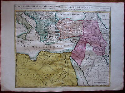
$11.85 Shipping Location: Dover, United States Carte Particuliere des Pais ou Les Apotres ont Preche l'Euan Gile; des Lieux les Plus Renommez de Leurs Voyages. Et de la Route de St. Paul a Rome. ... moreDressee pour bien entendre l'Histoire Sainte. Mediterranean. Arabia, Turkey, Greece, Armenia, North Africa) Issued Amsterdam. C. 1730-40 by Covens& Mortier. Fine mid-18th century engraved folio sheet map of the Mediterranean and Middle East. With original hand color. Quite interesting for the detailed depiction of Arabia. Armenia and Turkey during the time of the Apostles travels. In VG to near fine. Clean, well-preserved condition. A fine map. Sheet measures c. 24" W x 17" H. Printed area c. 18 1/4" W x 15" H. Folio. Tooleys Dictionary of Mapmakers. Vol. 1, p. 308. Marco van Egmond. Covens& Mortier. 3.3 R564. Everything we offer is guaranteed to be an authentic original antique item as described. We stand behind everything we sell. Important information for International Buyers* You may be charged customs. Taxes or other import duties by your country! this has nothing at all to do with us. Please do not hold us responsible if your Government wants to collect tax when you buy something outside of your country] Import duties. Taxes, and customs fees are not included in the item price or shipping cost. These charges are normally collected by the shipping service when the package is delivered or when you pick the item up. They are the buyer's responsibility and are not additional shipping charges. Please understand they have nothing to do with us and we have no control over them] Please check with your country's customs office to determine what these additional costs will be prior to bidding or buying. We do not know the various rules of your Customs office. There are a lot of countries in the world. Most with complex detailed variable laws in languages we don't read. Plus these laws are constantly being changed& revised] We won't under-value merchandise or mark the item as a gift on customs forms. Doing so is again
Buy It Now
$11.85 Shipping Location: Dover, United States Issued Amsterdam, c.1711 by Covens & Mortier. Covens & Mortier, 3.3. Scarce early 18th century folio sheet Dutch issued map of the Holy Land. Engraved ... morewith original hand color.
Buy It Now
Free Shipping Location: Netherlands Description: This map originates from the 1588 edition of 'Discrittione di tutti i Paesi Bassi', by L. Guicciardini, published by J. Janssonius. We carry ... moremost maps from this book which was published from 1581-1648. Artists and Engravers: The author of the book this old print originates from is Lodovico Guicciardini (1521-1589): an Italian merchant from aristocratic descent. At our website you will find a more extensive biography.
Buy It Now
$3.75 Shipping Location: United States Superb, rare, fine antique circa 1880 color lithographed map, titled Map of Kansas City, Missouri and Kansas City, Missouri. Beautifully detailed and ... moreattractive period map. The size of the map is 13" by 17.5".
$72.30 Shipping Location: Farmingdale, United States He was both an engraver and publisher of considerable reputation who was made Hydrographer to King George III. He worked with many of his contemporaries ... moreon various projects. LONDON: Printed for R. & J. Dodsley.
Buy It Now
$3.50 Shipping Location: Winter Springs, United States Belin is a highly regarded mapmaker of this period. Very finely produced, printed on superb paper, with no printing on reverse. The gorgeous handcoloring ... moreis period to the map, this is before color printing.
Buy It Now
$3.50 Shipping Location: Winter Springs, United States Very fine, superb, rare, antique 1765 copperplate engraved map, titled, in fancy antique lettering, An Accurate Map of the Southern Part of Lower Saxony ... moreDrawn from the best Authorities. Very finely produced, printed on thick period handmade paper, with no printing on reverse.
Buy It Now
$2.65 Shipping Location: Winter Springs, United States Fine antique 1800 copperplate engraved map, titled Germany divided into Circles. Very nicely engraved, attractive and detailed period map of this area. ... moreThe map is printed on fine period handmade paper, no printing on reverse.
Buy It Now
$3.75 Shipping Location: United States Superb, fine antique 1889 color lithographed map, titled South Africa, nicely detialed, much has changed. Nicely detailed, beautiful color and fascianting ... moreperiod details and information, printed on thick paper, very nice period color lithography.
Buy It Now
$4.00 Shipping Location: Winter Springs, United States Very fine, large antique 1886 handcolored 2 sided map, one side is titled Germany No 3, reverse is Germany No 4. This is a Colton map, Colton was a highly ... moreregarded mapmaker of this period. The gorgeous handcoloring is period to the map, this is before color printing.
Buy It Now
$3.75 Shipping Location: United States Superb, fine antique 1889 color lithographed 2 sided map, titled China, with inset map of Japan, reverse is Persia. Nicely detailed, beautiful color and ... morefascianting period details and information, printed on thick paper, very nice period color lithography.
Buy It Now
$4.00 Shipping Location: United States E ven the water areas are handcolored a delicate light blue. Fine period map of this part of the world. The map has 2 light crease towards left hand side, ... moresee my photo. The map is printed thick fine paper, with no printing on reverse and with gorgeous period handcoloring, nice outside ornate border, and fascianting period details.
Buy It Now
$3.75 Shipping Location: United States Very interesting period 1744 map of Germany, I see many fascianting areas and details, too much to list, but the detail is amazing. Much has changed, ... moreI see Bordeaux, Langouedoc Province, Spanish Provinces at upper right and much more.
Buy It Now
$3.25 Shipping Location: Winter Springs, United States The size is 10" by 16". FREE scheduling, supersized images.
Buy It Now
$3.75 Shipping Location: United States Superb, fine antique 1889 color lithographed 2 sided map, titled Japan, and reverse is Russia in Asia, Turkestan & Etc. Nicely detailed, beautiful color ... moreand fascianting period details and information, printed on thick paper, very nice period color lithography.
Buy It Now
$132.05 Shipping Location: Lansing, United States That region is the focal point of the present map. A lot of ink has been spilled speculating on the original source of the view, but it is generally thought ... moreto have been drawn in 1652, while Visscher’s version is regarded as the earliest obtainable version thereof and thus the earliest obtainable printed view of New York City.

Buy It Now
Free Shipping Location: Netherlands ABOUT US VISIT OUR STORE SALES SPECIALS ANTIQUE MAP-LIMBURG-NETHERLANDS-BACHIENE-1758 Description: This scarse rare old map originates from: Kort begrip ... moreder Oude en Nieuwe Staatkundige Geographie' By W.A. Bachiene, published by Covens& Mortier in 1758, printed in Utrecht by Jan Jakob van Pootsum. Artists and Engravers: Author: Willem Albert Bachiene(Leerdam 1712- Maastricht 1783) He was a Clergyman in the army and in Namen. Belgium and Kuilenburg(Culemborg) From 1759 he was Clergyman in Maastricht and also Professor in Astronomy and Geography at the'Illustere School' This map was engraved by Jacobus Harrewijn-Harrewyn(1660-1727) after I. Peeters. Subject: Province of Limburg and Valkenburg. The Netheland(Limburgi Ducatus et Comitatus Valckenburgi' Condition: Fine; tiny pinhole near middle fold; small tear in bottom middle fold; a few light stains. Size(in cm) The overall size is ca. 20 x 17.5 cm. The image size is ca. 18.5 x 14.7 cm. Size(in inch) The overall size is ca. 7.9 x 6.9 inch. The image size is ca. 7.3 x 5.8 inch. Medium: Copperplate engraving on verge type hand laid paper(watermark not visible on every sheet) Location: A47-08 ThePrintsCollector Peter Cornelissen. Margo van Latum- van Dongen, Frank van Latum Zeeland- The Netherlands Phone: +31 654 21 23 78 Worldwide free shipping on all orders. We ship within one business day upon receipt of payment. We ship by Registered Mail. Insurance is included. We guarantee our items to be genuine original. Visit our Store: we would like to invite you to review similar items in our Store or to browse through all other items in our Store. We are confident that you will find very special unique antique maps and prints in our Store. It is our privilege to have you as a customer. We accept Paypal payments and payment by bank transfer. Combined auction/ buy it now orders are possible! We will send a Paypal invoice on request! THE PRINTSCOLLECTOR GUARANTEES ITEMS SOLD THROUGH EBAY ARE GENUINE ORIGINAL ANTIQUE PRINTS IN THE CONDITION/TECHNIC AS D
Buy It Now
$29.75 Shipping Location: Louisville, United States Considerable detail is seen in the interior, cities, towns, mountain ranges and the two famous bodies of water, the Sea of Galilee and the Dead Sea. Map ... moreof the Holy Land. Old reproduction but I'm not sure from when.
Buy It Now
$9.90 Shipping Location: Dover, United States Issued c. 1740-50, Nuremberg by Homann. Fine mid 18th century folio sheet engraved map, with full original hand color.
Buy It Now
$4.13 Shipping Location: Miami, United States A vintage Colorprint General Atlas of the World. Has pages showing different parts of the world and a page showing the flags of the nations. In good condition ... morebut the cover is ripped at the bidding. Please see pictures and let me know if you have any questions! Posted with
Buy It Now
$3.25 Shipping Location: Winter Springs, United States Superb, very fine early antique 1858 handcolored map, the map is printed on fine thick paper, with no printing on reverse. This is a Morse and Gaston ... moremap. Morse was a highly regarded mapmaker of this period.
Buy It Now
$3.00 Shipping Location: United States Fine antique 1854 handcolored map, titled Germany. Austria is shown as part of Germany. Attractive and interesting period map of these areas. Printed ... moreon fine thick paper, no printing on reverse. The size of the map is 5.25" by 7".
Buy It Now
$19.75 Shipping Location: Akron, United States Published in Venice: Giovanni Magini, c. 1596. Verso text: Latin. Engraved map on hand-made paper. (Ref: Burden # 93). From the 1596 edition edited by ... morethe distinguished Italian geographerGiovanni Magini, and engraved in this format byGirolamo Porro.
Buy It Now
Free Shipping Location: Orlando, United States Originally from the National Illustre this print was made by "V. Levasseue" and colored by hand. In the lower left corner is a blue ink stamp which reads ... more"Societe de Beaux Arts Nantes" and a blind stamp low right margin "AC" which could indicate this was an exhibited print.
Buy It Now
$3.50 Shipping Location: Winter Springs, United States Very fine period color lithographed map, printed on thick paper, with no printing on reverse. Very detailed and attractive period map. The size of the ... moremap is 9" by 11". FREE scheduling, supersized images.
Buy It Now
$6.95 Shipping Location: Dover, United States Issued c. 1862, Paris by Andriveau-Goujon. Very uncommon scarce mid 19th century folio sheet lithographed map with original hand color. Decorative piano ... morekey border. From a rare atlas of this era. 2" split at centerfold base which touches just into the border and is now closed on reverse with archival tape (all but invisible once map is laid open flat).
Buy It Now
$11.85 Shipping Location: Dover, United States Issued 1872, New York by Asher & Adams. California & Nevada. Clean condition, light old damp staining in blank margin, small scattered age spots. Uncommon ... moreoversized 19th century lithographed map with original hand color.
Buy It Now
$4.00 Shipping Location: United States The map is printed on fine thick paper, with fascianting period details, and superb period handcoloring, showing Worcester County. The map is very detailed. ... moreThe map is printed on very thick fine paper, with no printing on reverse.
Buy It Now
$3.65 Shipping Location: Shrewsbury, United States Fine antique 1902 color lithographed map, titled Kansas. Nicely detailed, and beautiful period color lithography. The size of the map is 11" by 14.5". ... moreFREE scheduling, supersized images.
Buy It Now
$3.75 Shipping Location: Winter Springs, United States The map is titled Plan of the State of New York, titled in fancy antique lettering. Printed on thick paper, with no printing on reverse. This is an antique ... moremap and not a reprint or reproduction. The handcoloring on the map is period to the map, this is before color printing.
Buy It Now
$4.00 Shipping Location: United States Antique 1872 handcolored map. The map is titled, in fancy antique lettering, Map of the State of Pennsylvania. The condition of the map is amazing. There ... moreis no printing on reverse, and the map is printed on thick fine paper.
Buy It Now
$3.25 Shipping Location: Winter Springs, United States Very fine, antique 1819 copperplate engraved map, titled Russia in Asia. Printed at bottom is Published May 1, 1819, by J. Mawman and the other Proprietors. ... moreThis dates the map very nicely. Very finely engraved, printed on superb paper, no printing on reverse.
Buy It Now
$3.50 Shipping Location: Winter Springs, United States Superb, very fine, antique color lithographed map, produced circa 1870-80, titled Land Surface Features. Upper right hand side has Reference to Colouring ... morechart, corresponding to the map itself. The size is 14" by 19".
Buy It Now
$3.75 Shipping Location: United States Delamarche 1834. I like how the year produced is right in the title, it dates the map nicely. The map is in beautiful condition, printed on fine superb ... morethick paper, with no printing on reverse. Printed on superb paper, with no printing on verso.
Buy It Now
$3.50 Shipping Location: Winter Springs, United States Fascinating and detailed period Texas map. Very finely printed, beautiful period color lithography, and printed on thick paper. The size of the map is ... more14" by 22", The map is in nice condition. FREE scheduling, supersized images.
Buy It Now
$4.00 Shipping Location: United States The condition of the map is excellent, just amazing, esp. given the age of the map. Fine outside ornate border. This is an antique map and not a reprint ... moreor reproduction, the map is printed on thick paper, with no printing on reverse.
Buy It Now
$10.00 Shipping Location: Cyprus 1# French Bourbourg antique map Bourbour, Beaulieu 1688. Fort De Link antique map Belgium France region by de Beaulieu 1688. Fortress Link near Cappelle-Brouck ... moreFrance, antique plan of the fortification area.
Buy It Now
$3.00 Shipping Location: United States Printed on fine thick paper, no printing on reverse. The size of the map is 5.25" by 7". FREE scheduling, supersized images.
Buy It Now
$4.99 Shipping Location: Fairview, United States Atlas zum Lehrbuch der Kosmischen Physik(Braunschweig, 1872), a copy of the title page is included for reference. An Authentic Antique Map: Not a Modern ... moreReproduction! It was originally published in the.
Buy It Now
$3.25 Shipping Location: Winter Springs, United States Fine, rare. antique 1880 color lithographed map, titled in fancy antique lettering and titled Eastern Hemisphere. Beautiful period map of this part of ... morethe world in 1880. The size of the map is 10.5" by 12".
Buy It Now
$4.00 Shipping Location: United States The map is very detailed and fascianting. This is an antique map and not a reprint or reproduction. The handcoloring on the map is period to the map, ... morethis is before color printing. The map is from the very rare 1884 Colby Atlas of Maine.
Buy It Now
Free Shipping Location: Putnam, United States Undated; appears (to my eye) to date from late 1890s. There are three portrait vignettes, plus a scene of Versailles. S E I N E ET O I S E . ANTIQUE MAP ... more"grave par Lecocq Barbier et Waltner".
Buy It Now
$3.75 Shipping Location: Winter Springs, United States The map is titled, in fancy antique lettering, Map of the State of Pennsylvania. The size of the map is 15.5" by 12.5". FREE scheduling, supersized images.
Buy It Now
$3.75 Shipping Location: Winter Springs, United States Beautiful map. The ap is in excellent condition, with a light stain at lower right hand side, not bad at all. Printed on thick paper, with no printing ... moreon reverse. The condition of the map is amazing.
Buy It Now
$3.00 Shipping Location: United States Fine antique 1854 handcolored map, titled Western Hemisphere. The fine handcoloring is period to the map, this is before color printing. Attractive and ... moreinteresting period Western Hemisphere map. Printed on fine thick paper, no printing on reverse.

Buy It Now
Free Shipping Location: Netherlands ABOUT US VISIT OUR STORE SALES SPECIALS Antique Manuscript Map-ITALY-SICILY-Van Bommel-1863 Description: Original manuscript map. Netherlands ca. 1865. ... moreArtists and Engravers: We acquired a series of maps by P. van Bommel. Some are dated 1863-1865. We have not been able to ind additional information on this cartographer. Draftsman or scholar. Subject: Map: Italie' Map of Italy. Hand drawn map by Dutch geography/ cartography student P. van Bommel. Condition: Fine. General age related toning. Irregular paper edges with small tears. Size(in cm) The overall size is ca. 26 x 33 cm. The image size is ca. 21.5 x 27 cm. Size(in inch) The overall size is ca. 10.2 x 13 inch. The image size is ca. 8.5 x 10.6 inch. Medium: Original drawing on a vellin type paper. Location: A195-14 ThePrintsCollector Peter Cornelissen. Margo van Latum- van Dongen, Frank van Latum Zeeland- The Netherlands Phone: +31 654 21 23 78 Worldwide free shipping on all orders. We ship within one business day upon receipt of payment. We ship by Registered Mail. Insurance is included. We guarantee our items to be genuine original. Visit our Store: we would like to invite you to review similar items in our Store or to browse through all other items in our Store. We are confident that you will find very special unique antique maps and prints in our Store. It is our privilege to have you as a customer. We accept Paypal payments and payment by bank transfer. Combined auction/ buy it now orders are possible! We will send a Paypal invoice on request! THE PRINTSCOLLECTOR GUARANTEES ITEMS SOLD THROUGH EBAY ARE GENUINE ORIGINAL ANTIQUE PRINTS IN THE CONDITION/TECHNIC AS DESCRIBED. ITEMS CAN BE RETURNED WITHIN 7 DAYS. Powered by
Buy It Now
$6.95 Shipping Location: Dover, United States Issued c. 1850's, Germany by Heck. Engraved by R. Schmidt. Remarkably detailed mid-19th century engraved city plan map with attractive hand color. Paris ... moreAls Waffenplatz.
|
|
|
In
|
Fine 1891 Original Antique Appleton Map ALABAMA Montgomery Birmingham Mobile AL
Fine Adornment of Alabama History. Impressive on Any Home or Office Wall. Imaginative& Creative Gift. 1891 Appleton Map of Alabama D. Appleton Map. Matthews-Northrup Engraved. Original 1891. 121-ys-old. Map is in Good/Very Good Condition: No marks. Writings, tears, or foxing. Not a Reproduction. Original Map Drawn and Engraved for the 1891 Edition of"The Library of Geography. Published by D. Appleton& Company, New York, and Engraved by Matthews-Northrup Engraving& Printing Works, Buffalo& New York, 1891. Exceptional Engraved Detail. Impressive Map for Any Home of Office Wall. A Fine Map for the Collector or Makes Quite an Impressionable Gift for Someone Living in or From Alabama. I Sell Only Original Maps: No copies or reproductions. Press Here to View my Collection. Impressive on Any Home or Office Wall Dimensions: 10" ... morex 14" Great for Genealogy As Map Shows Towns& Landmarks of 1891. Some of Which No Longer Exist Today. Imaginative& Creative Gift for Someone Living in or From Alabama. The Auction is for the Map Itself. A Frame is Not Included. The Framed Map Pictured is a Personal 1873 Bartholomew Map Featured to Show the Beauty of the Maps when Framed. Free Shipping Special. All Credit& Debit Cards along with Electronic Checks accepted through Paypal. Please email with any questions. Fine Adornment of Alabama History. Greetings from Historical Savannah. Georgia; founded 1733. Some. To beautify their halls, chambers, studies, and libraries.loveth, getteth, and useth maps, charts, geographical globes. John Dee. Advisor to Elizabeth I. Press the Link Below to View My Collection. Powered by The free listing tool. List your items fast and easy and manage your active items.
|
|
|
Fine Antique Civil War Lithograph Print CONFEDERATE DEFENSES ATLANTA Georgia GA
Original Plate of"The Official Atlas to Accompany the Official Records of the Union and Confederate Armies. Published by the Resolution of the U.S. Congress of May 19. 1864 as The Official Historical Record of The Civil War, and was Never Openly Sold, but Distributed only to Federal Depositories, University Libraries, Public Museums, Various Private& Public Concerns, And of Which Fewer Than 1.000 Complete Atlases Remain. A Fine Adornment of Civil War History. Impressive on Any Home or Office Wall. Imaginative& Creative Gift. Lithographic 1865 Photographs of Rebel Defenses of Atlanta Photographs Taken in 1865. Julius Bien Engraved. Original Plate of The Official Atlas to Accompany The Official Records of The Union& Confederate Armies. 175 Plates Issued in 35 Parts. Part 26. Plate CXXVII. Original Plate CXXVII(127) of the 175 ... moreIssued. Original 1894. 119-ys-old. Lithograph is in Good Condition: No writings or marks. Mild foxing. Nominal fraying along edge. Single fold as Issued. Not a Reproduction. Original Plate CXXVII(127) of the 175 Issued of The Atlas to Accompany the Official Records of the Union& Confederate Armies. Commissioned with a Resolution of Congress of May 19, 1864, Published Under the Direction of the Hon. Daniel S. Lamont, Secretary of War, by Major George B. Davis, Leslie J. Perry, and Joseph W. Kirkley, Board of Publications. Compiled by Calvin D. Cowles, 23rd Infantry, Washington, D.C. Government Printing Office, 1894; a copy of the Preface, Part Volume, Title Page of which is Included. Engraved by Julius Bien& Co. Lithographers. A Fine Rare Map for the Collector or Civil War Enthusiast or Makes Quite an Impressionable Gift. I Sell Only Original Antique Maps: No copies or reproductions. Press Here to View My Collection. Impressive on Any Home or Office Wall. Dimensions: 18" x 29.5" So Large It Makes Itself The Conversation of Any Room. Views Read: 1) Rebel Fort South of Chattanooga Railroad. 2) Rebel Fort. Atlanta. 3) Rebel Fort on Chattanooga Railroad. Atlanta.
|
|
|
North South Carolina Florida 1732 Moll with Azilia colony fine antique map
FREE GLOBAL SHIPPING ON ALL MAP/ PRINT ORDERS OVER $100* North South Carolina Florida 1732 Moll with Azilia colony fine antique map Carolina[showing the proposed settlement of" Azilia" Issued London. 1732 by Herman Moll. Fine and wellpreserved early 18th century engraved map with original outline hand color. In VG to VG+ clean condition. Some minor marginal spotting. Sheet uniformly moderately toned, faint bit of inoffensive dampstaining to bottom centerfold, edges toned, overall a visually attractive example. As discussed by Cummings[ Southeast in Early Maps] A great deal of then new place-name nomenclature is presented on this map. It also gives the location of numerous local Indian tribes which then still inhabited the state around this date(in places even saying how many villages were to be found) Also prominently names and ... morelocates the planned colonial settlement of" Azilia" it is seen in large letters above the word"South" in Carolina) Azilia" was a short-lived visionary plan of Sir Robert Montgomery to create a settlement of early English colonists south of the Savannah River. By walling and militarily planning the defenses. The settlement could thus withstand the assault of the local savages(indians) This plan resulted from the near collapse of South Carolina due to the then recent Yamasee War losses(see wikipedia for an overview of this seminal series of events and their effects) Azilia is identified and located in large letters on the map. This imaginary proposed settlement of Azilia appears on only a handful of printed Carolina maps. All of which are scarce or only found in manuscript form. Furthermore, this never-to-be-realized early American settlement only appears on the earliest states of this Moll map(it is changed to"Georgia" on later states) At bottom right. English claims within the region are delineated and described in six lines, thereby cartographically rebutting any claims by other European nations to the area. Below Florida's southern line is
|
|
|
Savannah River Georgia 1837 fine Blunt antique coastal chart map
Savannah River Issued 1837. New York by Blunt Fine antique engraved map printed in the mid 19th century. With attractive hand color. In near VG condition. Light minor age wear, bottom edge narrow with tiny chipping as often seen on this oversize oblong folding map, overall remaining clean and attractive. Pleasing example of this original antique map. Sheet measures c. 8 3/8" H x 18 1/8" W. Engraved area measures c. 7 1/2" H x 17 1/4" W. Tooleys Dictionary of Mapmakers. Vol.1, pp. 153-5. R656. Guaranteed Authentic! We do not sell modern reproductions. Condition All of our items are original antique pieces and it is important to keep in mind that many of them have been around for 100 years or more. Individual pieces may have seen many owners and been handled many times over the course of their existence and as a result each ... morepiece has developed a history of it's own. Short edge splits(often repaired with archival tape) Foxing, discoloration, etc. are all things to expect on items of this type. They rarely distract from the piece and often add to the overall character of the item. Keep in mind when you receive your item that you are not handling a modern copy, you are holding a piece of history, an item that has been around for a very long time and will, with proper care, be around for a long time to come. We try to note any significant flaws in the description, but less noticeable or common characteristics may not be mentioned. As we are a US based company all of our measurements are in Inches. If you need the size in Centimeters please multiply the supplied measurement by 2.53. Payment and Shipping We happily accept PayPal! Payment is appreciated within 5 days of invoicing. Once payment has been received we do our best to make sure all orders are shipped within two business days and often have them shipped within one. We send payment confirmation and a copy of the receipt to the email address associated with your PayPal payment. All orders are shipped well protected in sturdy tubes or flat w
|
|
|
South Carolina 1812 Arrowsmith & Lewis Indian Boundary fine antique map
South Carolina Issued 1812(1804 re-issued) Boston by Arrowsmith& Lewis. Engraved by David Fairman. Fine early 19th century engraved map with attractive hand color. One of the earliest maps printed in the 19th century which separately depicts the state. At top left is a large area"Indian Boundary" which disappears as do all the districts. By the time of the 1812 Carey map. Early roads shown, as well as topography, rivers, lighthouses, etc. A key early map for collectors. In near VG condition. Overall clean. Sheet measures c.8 3/4" H x 10 5/8" W. Engraved area measures c. 7 3/4" H x 9 3/4" W. Karpinski. Early Maps of Carolina. Collection of H.P. Kendall, 97(citing the 1804 issue) Rumsey Collection. 0028.044(this 1812 issue depicted) R492. Guaranteed Authentic! We do not sell modern reproductions. Condition ... moreAll of our items are original antique pieces and it is important to keep in mind that many of them have been around for 100 years or more. Individual pieces may have seen many owners and been handled many times over the course of their existence and as a result each piece has developed a history of it's own. Short edge splits(often repaired with archival tape) Foxing, discoloration, etc. are all things to expect on items of this type. They rarely distract from the piece and often add to the overall character of the item. Keep in mind when you receive your item that you are not handling a modern copy, you are holding a piece of history, an item that has been around for a very long time and will, with proper care, be around for a long time to come. We try to note any significant flaws in the description, but less noticeable or common characteristics may not be mentioned. As we are a US based company all of our measurements are in Inches. If you need the size in Centimeters please multiply the supplied measurement by 2.53. Payment and Shipping We happily accept PayPal! Payment is appreciated within 5 days of invoicing. Once payment has been received we do our best to make sure a
|
|
|
Fine Large Original 1892 Antique Map JAMAICA Kingston CUBA Havana Puerto Rico
Fine Adornment of History. Impressive on Any Home or Office Wall. Imaginative& Creative Gift. Large 1892 Appleton Map Jamaica& Cuba( Lessor Antilles) Fine D. Appleton Map. Matthews-Northrup Engraved. Original 1892. 120-ys-old. Map is in Good/Very Good Condition: No marks. Writings, or tears. Mild foxing. Nominal fraying at fold indentation. Single fold as Issued. Not a Reproduction. Original Map Drawn and Engraved for the 1892 Edition of"The Library of Geography. Published by D. Appleton& Company, New York, and Engraved by Matthews-Northrup Engraving& Printing Works, Buffalo& New York, 1892. Exceptional Engraved Detail. Impressive Map for Any Home of Office Wall. A Fine Map for the Collector or Makes Quite an Impressionable Gift. I Sell Only Original Maps: No copies or reproductions. Press Here to View my Collection. ... moreImpressive on Any Home or Office Wall Dimensions: 13.5" x 19.5" Exceptional Engraved Detail. Beautiful Map. The Auction is for the Map Itself. A Frame is Not Included. The Framed Map Pictured is a Personal 1873 Bartholomew Map Featured to Show the Beauty of the Maps when Framed. Free Shipping Special. All Credit& Debit Cards along with Electronic Checks accepted through Paypal. Maps are mailed within 1-3 days of payment and normally arrive within 3-7 days. Please email with any questions. Fine Adornment of History. Greetings from Historical Savannah. Georgia; founded 1733. Some. To beautify their halls, chambers, studies, and libraries.loveth, getteth, and useth maps, charts, geographical globes. John Dee. Advisor to Elizabeth I. Press the Link Below to View My Collection. Powered by The free listing tool. List your items fast and easy and manage your active items.
|
|
|
North Carolina showing gold region 1846 Mitchell Dismal Swamp fine antique map
A New Map of North Carolina With its Canals. Roads& Distances from place to place along the Stage& Steam Boat Routes. Issued 1846[1848] Phila.by Samuel Augustus Mitchell. Fine mid-19th century lithographed American state map with attractive original hand color. Includes an inset of the"gold region" of the state at bottom left. Inset of Neuse River and Newbern harbor area at top left, three column Table of Distances beside it. Paper evenly and moderately toned as typical. Light minor scattered foxing along edges and in blank margins, otherwise clean and attractive. Sheet Measures c.16 3/4" W x 13 3/4" H. Engraved area measures c. 13 3/4" W x 11 1/2" H. Folio. A lovely map for display. Tooleys Dictionary of Mapmakers. Vol. 3, pp. 260-1. R696. Guaranteed Authentic! We do not sell modern reproductions. Condition ... moreAll of our items are original antique pieces and it is important to keep in mind that many of them have been around for 100 years or more. Individual pieces may have seen many owners and been handled many times over the course of their existence and as a result each piece has developed a history of it's own. Short edge splits(often repaired with archival tape) Foxing, discoloration, etc. are all things to expect on items of this type. They rarely distract from the piece and often add to the overall character of the item. Keep in mind when you receive your item that you are not handling a modern copy, you are holding a piece of history, an item that has been around for a very long time and will, with proper care, be around for a long time to come. We try to note any significant flaws in the description, but less noticeable or common characteristics may not be mentioned. As we are a US based company all of our measurements are in Inches. If you need the size in Centimeters please multiply the supplied measurement by 2.53. Payment and Shipping We happily accept PayPal! Payment is appreciated within 5 days of invoicing. Once payment has been received we do our best to mak
|
|
|
South Carolina Georgia Florida &c 1875 large lithograph fine antique map
Map of South Carolina. Georgia, Florida, Alabama, Mississippi, and Louisiana" issued Chicago. 1875. A beautifully lithographed and somewhat uncommon 19th-century map. With full original hand color. An interesting 19th century folio sheet map. In VG overall clean condition. Faint offsetting scarcely worthy of mention. Sheet measures c. 19 1/2" H x 14" W Printed area measures c. 17" H x 12" W. R769 Guaranteed Authentic! We do not sell modern reproductions. Condition All of our items are original antique pieces and it is important to keep in mind that many of them have been around for 100 years or more. Individual pieces may have seen many owners and been handled many times over the course of their existence and as a result each piece has developed a history of it's own. Short edge splits(often repaired with archival ... moretape) Foxing, discoloration, etc. are all things to expect on items of this type. They rarely distract from the piece and often add to the overall character of the item. Keep in mind when you receive your item that you are not handling a modern copy, you are holding a piece of history, an item that has been around for a very long time and will, with proper care, be around for a long time to come. We try to note any significant flaws in the description, but less noticeable or common characteristics may not be mentioned. As we are a US based company all of our measurements are in Inches. If you need the size in Centimeters please multiply the supplied measurement by 2.53. Payment and Shipping We happily accept PayPal! Payment is appreciated within 5 days of invoicing. Once payment has been received we do our best to make sure all orders are shipped within two business days and often have them shipped within one. We send payment confirmation and a copy of the receipt to the email address associated with your PayPal payment. All orders are shipped well protected in sturdy tubes or flat white mailers(depending on size) via the U.S. Post Office. Please be aware that once we have s
|
|
|
Florida Carolinas Georgia 1806 Cary Southern US fine folio antique map
A New Map of Part of the United States of North America Containing the Carolinas and Georgia. Also the Floridas and Part of the Bahama Islands&c. Issued London. 1806 by Cary. Wonderfully detailed and well-preserved early 19th century folio sheet map of the southern US region. In VG to VG+. Mostly clean condition. Some light offsetting in water areas and light scattered foxing. Otherwise map remains clean and quite well-preserved overall, very pleasing visually. Cary's maps were issued in a variety of coloring levels. This example with full block color heightened in outline and with the sea area colored displaying the highest and visually most pleasing. The Rumsey Collection example is of the type more frequently encountered, with outline hand color. Sheet measures c. 25" W x 21 3/8" H. Engraved area c. 20 3/8" W x 18 ... more1/8" H. Original fold line as issued. Tooleys Dictionary of Mapmakers. Vol. 1 p. 239. R243. Guaranteed Authentic! We do not sell modern reprints. Condition All of our items are original antique pieces and it is important to keep in mind that many of them have been around for 100 years or more. Individual pieces may have seen many owners and been handled many times over the course of their existence and as a result each piece has developed a history of it's own. Short edge splits(often repaired with archival tape) Foxing, discoloration, etc. are all things to expect on items of this type. They rarely distract from the piece and often add to the overall character of the item. Keep in mind when you receive your item that you are not handling a modern copy, you are holding a piece of history, an item that has been around for a very long time and will, with proper care, be around for a long time to come. We try to note any significant flaws in the description, but less noticeable or common characteristics may not be mentioned. As we are a US based company all of our measurements are in Inches. If you need the size in Centimeters please multiply the supplied measurement by 2
|
|
|
Original 1890 Antique Map of NORTH CAROLINA Brightly Colored FINE DETAIL Lovely
Here is an authentic map that was published in the 1890s. It would be easy to frame for a handsome presentation for your home or office. Map Title: North Carolina Date: 1890s Publisher: Not Known Size: 10 x 12.5 inches Features: Original antique map. Not a reproduction. Brightly colored in orange and yellow tints for an eye-catching display. Details are clearly laid out and include Cities, Towns, Villages, Railroads, Canals, geographical features. Condition: Near Fine. The paper is supple and not brittle. And the entire map area is clean and free of any marks or tears. There is a fold down the center as issued. Shipping: The map will be packaged with care and securely mailed within 48 hours of payment. This handsome map is a window into the past that will provide you with many hours of enjoyment and delight. Not just an historical document. ... moreIt is also a unique work of art that can be easily framed and proudly displayed. Thanks for looking! I package carefully and ship securely. Please feel free to email me at any time with your thoughts or questions- I am always happy to respond!
|
|
|
Savannah River by Blunt Tybee Island Light House 1822 fine antique nautical map
Savannah River Engraved by W. Hooker for Blunt's Coast Pilot(Georgia) Issued New York. 1822 Fine and uncommon nautical chart/ map. With attractive hand color. Printed on period paper as issued which remains sound and supple. Nicer than typical example for this oblong folding chart which is often found in far worse condition. A picture is worth a thousand words. The photos are a major part of the item description. Please examine them closely. As what you see is what we will send you. note: we grade conservatively and always seek to disclose any noteworthy flaws. Map remains overall clean& sound. Old maps often display small minor repairs on the back. Could have uneven blank margins, might have extraneous fold-lines or other small minor age flaws which do not detract from the visual appeal or value. Condition is carefully considered ... morein the price. Great map entirely worthy of hanging for display. A cartographic depiction captured in a manner entirely unique to this era. Sheet measures c. 8 5/8" H x 19" W. Printed area measures c. 8" H x 17 7/8" W Tooleys Dictionary of Mapmakers. V. 1 p. 152* R1382] Everything we offer is guaranteed to be an authentic original antique item as described. We stand behind everything we sell. Important information for International Buyers* You may be charged customs. Taxes or other import duties by your country! this has nothing at all to do with us. Please do not hold us responsible if your Government wants to collect tax when you buy something outside of your country] Import duties. Taxes, and customs fees are not included in the item price or shipping cost. These charges are normally collected by the shipping service when the package is delivered or when you pick the item up. They are the buyer's responsibility and are not additional shipping charges. Please understand they have nothing to do with us and we have no control over them] Please check with your country's customs office to determine what these additional costs will be prior to bidding or
|
|
|
North Carolina 1800 fine rare antique map by A. Anderson
North Carolina from the best Authorities 1800 Issued ca. 1800-1806. NY by J. Low Engraved by A. Anderson Fine and uncommon antique map. A picture is worth a thousand words. The photos are a major part of the item description. Please examine them closely. As what you see is what we will send you. note: we grade conservatively and always seek to disclose any noteworthy flaws. Average or better condition. Some light offsetting as typical for folded maps of this era. Small insignificant paper flaws in bottom blank margins, overall very clean and attractive. Map remains overall clean& sound. Old maps often display small minor repairs on the back. Could have uneven blank margins, might have extraneous fold-lines or other small minor age flaws which do not detract from the visual appeal or value. Condition is carefully considered in arriving ... moreat our price. Great map entirely worthy of hanging for display. A cartographic depiction captured in a manner entirely unique to this era. Sheet measures c. 9 5/8" H x 13" W. Printed area measures c. 7 1/2" H x 12 3/4" W. Original fold-lines as issued. Stauffer. American Engravers, v.1, p. 9* noting Alexander Anderson was an MD who was self-trained as an engraver. He is considered the"Father of Wood-Engraving" in America) Tooleys Dictionary of Mapmakers. V. 1, p. 29* R1428] Everything we offer is guaranteed to be an authentic original antique item as described. We stand behind everything we sell. Important information for International Buyers* You may be charged customs. Taxes or other import duties by your country! this has nothing at all to do with us. Please do not hold us responsible if your Government wants to collect tax when you buy something outside of your country] Import duties. Taxes, and customs fees are not included in the item price or shipping cost. These charges are normally collected by the shipping service when the package is delivered or when you pick the item up. They are the buyer's responsibility and are not additional ship
|
|
|
South Carolina state map 1799 fine antique map Wheat & Brun #608
The State of South Carolina from the best Authorities 1799 Issued 1799 plate(1806 re-issue) NY Engraved by Scoles(John) Fine and uncommon 18th century antique American map. A picture is worth a thousand words. The photos are a major part of the item description. Please examine them closely. As what you see is what we will send you. note: we grade conservatively and always seek to disclose any noteworthy flaws. In Average condition. typical mostly light scattered foxing and a hint of light offsetting as seen. Nice margins all around although bottom is narrow(plenty wide for framing) Despite the toning& foxing. Map still displays an entirely appealing visual quality. Map remains overall clean& sound. Old maps often display small minor repairs on the back. Could have uneven blank margins, might have extraneous fold-lines opr other small ... moreminor age flaws which do not detract from the visual appeal or value. Condition is carefully considered in arriving at our price. Great map entirely worthy of hanging for display. A cartographic depiction captured in a manner entirely unique to this era. Sheet measures c. 7 7/8" H x 9 3/8" W. Printed area measures c. 7 1/2" H x 8 5/8" W. Wheat& Brun. Maps& Charts Published in America Before 1800. 608- Variant- W& B noting this exact map but the plate has been altered below the neat line by Low to change the source to read"New Encyclopedia" instead of"Paynes Geography" both works were issued by Low) Tooleys Dictionary of Mapmakers. V. 4, p. 136. R1452] Everything we offer is guaranteed to be an authentic original antique item as described. We stand behind everything we sell. Important information for International Buyers* You may be charged customs. Taxes or other import duties by your country! this has nothing at all to do with us. Please do not hold us responsible if your Government wants to collect tax when you buy something outside of your country] Import duties. Taxes, and customs fees are not included in the item price
|
|
|
Southern States Mississippi Georgia Arkansas c.1828 fine antique color map
Southern States(Louisiana. Mississippi, Alabama, Georgia, South& North Carolina) Fine and uncommon antique map with original hand color. A picture is worth a thousand words. The photos are a major part of the item description. Please examine them closely. As what you see is what we will send you. note: we grade conservatively and always seek to disclose any noteworthy flaws. Clean map overall. Light browning along centerfold as often seen on American maps of this era. Map remains overall clean& sound. Old maps often display small minor repairs on the back. Could have uneven blank margins, might have extraneous fold-lines opr other small minor age flaws which do not detract from the visual appeal or value. Condition is carefully considered in arriving at our price. Great map entirely worthy of hanging for display. A cartographic depiction ... morecaptured in a manner entirely unique to this era. Sheet measures c. 11 7/8" H x 18 1/2" W. Printed area measures c. 9 7/8" H x 16 1/4" W Original fold line as issued. R1491] Everything we offer is guaranteed to be an authentic original antique item as described. We stand behind everything we sell. Important information for International Buyers* You may be charged customs. Taxes or other import duties by your country! this has nothing at all to do with us. Please do not hold us responsible if your Government wants to collect tax when you buy something outside of your country] Import duties. Taxes, and customs fees are not included in the item price or shipping cost. These charges are normally collected by the shipping service when the package is delivered or when you pick the item up. They are the buyer's responsibility and are not additional shipping charges. Please understand they have nothing to do with us and we have no control over them] Please check with your country's customs office to determine what these additional costs will be prior to bidding or buying. We do not know the various rules of your Customs office. There are a lot of count
|
|
|
Savannah River Georgia Cock Spur Island 1837 Blunt fine antique nautical map
Savannah River. From its Mouth to the City of Savannah(Georgia) Issued 1837. NY by E. G.W. Blunt Fine and uncommon old map of Savannah River which exists in more than one state. With lovely hand color. A picture is worth a thousand words. The photos are a major part of the item description. Please examine them closely. As what you see is what we will send you. note: we grade conservatively and always seek to disclose any noteworthy flaws. Map remains well preserved. Some light age wear or minor surface spotting/ soiling which is visible within the scan. Overall quite clean and nicer than typical. Paper and image remains overall clean& sound. Old maps& prints often display small minor repairs on the back. Could have uneven blank margins, might have extraneous fold-lines or other small minor age flaws which do not detract from the visual ... moreappeal or value. Condition is carefully considered in arriving at our price. Great antique map entirely worthy of hanging for display. A depiction captured in a manner entirely unique to this era. Sheet measures c. 8 7/8" H x 17 7/8" W. Printed area measures c. 7" H x 16 1/8" W Tooleys Dictionary of Mapmakers. V. 1, p. 153 Original fold lines as issued. R1559] Everything we offer is guaranteed to be an authentic original antique item as described. We stand behind everything we sell. Important information for International Buyers* You may be charged customs. Taxes or other import duties by your country! this has nothing at all to do with us. Please do not hold us responsible if your Government wants to collect tax when you buy something outside of your country] Import duties. Taxes, and customs fees are not included in the item price or shipping cost. These charges are normally collected by the shipping service when the package is delivered or when you pick the item up. They are the buyer's responsibility and are not additional shipping charges. Please understand they have nothing to do with us and we have no control over them] Please check with your
|
|
|
SUPERB ANTIQUE 1893 NORTH CAROLINA MAP OUTER BANK RAILROAD DETAILED FINE NR
Click Here. Double your traffic. Get Vendio Gallery- Now FREE! Very fine. Antique 1893 color lithographed map. The map is titled North Carolina, very detailed and fascianting period map. The map is from the very rare 1893 Wanamaker Atlas of the World. Very nicely color lithographed period map, printed on fine paper. The size of the map is 12" by 13.5" Rare. Winning bidder pays $3.50 shipping domestic, more foreign. Payment I accept the following forms of payment: PayPal Click to View Image Album Shipping& Handling US Shipping. $3.50 USPS First-Class Mail® International Shipping. $9.50 USPS First-Class Mail International FREE scheduling. Supersized images and templates. Get Vendio Sales Manager. FREE scheduling. Supersized images and templates. Get Vendio Sales Manager.
|
|
|
Mississippi ca. 1840 Bradford scarce fine antique map Stiles Sherman & Smith
Mississippi(Southern United States) Issued ca. 1838-40 by Bradford Engraved by Stiles. Sherman& Smith(specialist Bank Note engravers) Fine and rather uncommon old engraved map with faint original hand coloring. A picture is worth a thousand words. The photos are a major part of the item description. Please examine them closely. As what you see is what we will send you. note: we grade conservatively and always seek to disclose any noteworthy flaws. Map remains well preserved. Some light age wear or surface spotting/ soiling which is visible within the scan. Short edge split at top center margin, minor staining in bottom right blank margin, overall visually appealing and clean. Paper and image remains overall clean& sound. Old maps& prints often display small minor repairs on the back. Could have uneven blank margins, might have ... moreextraneous fold-lines or other small minor age flaws which do not detract from the visual appeal or value. Condition is carefully considered in arriving at our price. Great antique map entirely worthy of hanging for display. A depiction captured in a manner entirely unique to this era. Sheet measures c. 18 1/8" H x 14 1/2" W. Printed area measures c. 14 1/8" H x 11" W Tooleys Dictionary of Mapmakers. V. 4, p. 219* Sheets. American maps, p.56. R1753] Everything we offer is guaranteed to be an authentic original antique item as described. We stand behind everything we sell. Important information for International Buyers* You may be charged customs. Taxes or other import duties by your country! this has nothing at all to do with us. Please do not hold us responsible if your Government wants to collect tax when you buy something outside of your country] Import duties. Taxes, and customs fees are not included in the item price or shipping cost. These charges are normally collected by the shipping service when the package is delivered or when you pick the item up. They are the buyer's responsibility and are not additional shipping charges. Please understand the
|
|
 |