-
Christian Collectibles
-
Christian Sheet Music
-
Vatican Stamps
-
Vatican Coins & Paper Money
-
Antiques
-
Antiquities
-
Architectural & Garden
-
Decorative Arts
-
Ethnographic
-
Furniture
-
Maps, Atlases & Globes
-
United States (Pre-1900)
-
AK, HI
-
AL, FL, GA, MS, NC, SC
-
AR, IA, KS, LA, MO, NE
-
AZ, CA, CO, NM, NV, UT
-
CT, MA, ME, NH, RI, VT
-
DC, DE, MD, NJ, NY, PA
-
ID, OR, WA
-
IL, IN, MI, OH, WI
-
MN, MT, ND, SD, WY
-
OK, TX
-
VA, WV, KY, TN
-
Entire US
-
United States (1900-Now)
-
United States (Date Unknown)
-
Africa
-
Asia
-
Australasia/ Oceania
-
Canada
-
Central America/ Caribbean
-
Europe
-
India
-
Ireland
-
Mexico
-
Middle East
-
North America
-
South America
-
United Kingdom
-
Maps on CD
-
World Maps
-
Globes
-
Mixed Lots
-
Reproductions
-
Price Guides & Publications
-
Other
|
In
Order by: Available to: This site contains affiliate links for which I may be compensated
|
Buy It Now
$8.70 Shipping Location: Encinitas, United States Excellent condition copper plating map. One small foxing spot. Full margins. Prior under glass with matting. I have no doubt on authenticity originality ... moreof this map based on extensive research. Size 15" x 12.5".
Buy It Now
$6.00 Shipping Location: Pasadena, United States This is a beautiful hand-colored engraving of an Asia map from the Atlas Illustrae Paris circa 1850. The map is in the format of an atlas and is perfect ... morefor collectors or those interested in antique maps. The colors are vibrant and the details are intricate, making it a wonderful addition to any collection.
Buy It Now
$12.45 Shipping Location: Newtown, United States Hand Colored Map Johnson's Atlas Mexico Mazatlan Guadalajara Cancun Mexican 1862. Shipped with USPS Priority Mail.
Buy It Now
$21.60 Shipping Location: Dover, United States Schoolatlas van Nederland en Zijne Overzeesche Bezittingen door A. A. Beekman, in 24 Kaarten. First Edition, 24 color lithographed, all folded and inset ... moreas issued, scarce Dutch atlas. Short video captures condition much better than words.
$6.05 Shipping Location: Schwenksville, United States 1862 Mitchell's New General Atlas Hand Colored Maps. 47 of 80 maps included. Many pages are detached from the binding. There is wear, tear and discoloration.
Buy It Now
$10.04 Shipping Condition: Unspecified Location: LONDON, United Kingdom West Indies [inset: Panama Railway, Jamaica]. Caption below picture:'West Indies [inset: Panama Railway, Jamaica]'. Antique atlas map with original hand ... morecolouring / coloring, 1854. PROVENANCE: "General Atlas of the World", by Sidney Hall, William Hughes FRGS &c. new edition, Edinburgh; Adam & Charles Black, North Bridge.
Buy It Now
$10.04 Shipping Condition: Used Location: LONDON, United Kingdom 'The Windward or South Caribbean Islands'. Caption below picture:'The Windward or South Caribbean Islands'. Antique engraved atlas map with original hand ... morecolour/color, 1860. DATE PRINTED: 1860.
Buy It Now
$33.88 Shipping Condition: Unspecified Location: LONDON, United Kingdom 'Am�rique Septentionale'. Caption below picture:'Am�rique Septentionale'. Wide margins, 1856. DATE PRINTED: 1856. CONDITION: Good; suitable for framing. ... moreThe map you will receive is in good condition but there may be minor variations in the condition from that shown in the image.
Buy It Now
$10.04 Shipping Condition: Unspecified Location: LONDON, United Kingdom Antique engraved atlas map with original hand colour/color, 1859. DATE PRINTED: 1859. TYPE: Antique engraved atlas map with original hand colour/color. ... moreAUTHENTICITY: This is an authentic historic print, published at the date stated above.
Buy It Now
$10.04 Shipping Condition: Unspecified Location: LONDON, United Kingdom CONDITION: Good; suitable for framing. The map you will receive is in good condition but there may be minor variations in the condition from that shown ... morein the image. Antique engraved copperplate map with original outline colour, 1793.
Buy It Now
$10.04 Shipping Condition: Used Location: LONDON, United Kingdom 'New Brunswick, Nova Scotia, Prince Edward Island, and part of Canada East'. Caption below picture:'New Brunswick, Nova Scotia, Prince Edward Island, ... moreand part of Canada East'. Antique engraved atlas map with original hand colour/color, 1860.
Buy It Now
$10.04 Shipping Condition: Used Location: LONDON, United Kingdom Antique map with original outline colour, 1863. DATE PRINTED: 1863. CONDITION: Good; suitable for framing. The map you will receive is in good condition ... morebut there may be minor variations in the condition from that shown in the image.
Buy It Now
$10.04 Shipping Condition: Used Location: LONDON, United Kingdom 'The Island of Borneo'. Caption below picture:'The Island of Borneo'. Antique engraved atlas map with original hand colour/color, 1860. DATE PRINTED: ... more1860. VERSO: There is nothing printed on the reverse side, which is plain.
Buy It Now
$11.95 Shipping Location: Swampscott, United States
Buy It Now
$10.00 Shipping Location: Rockville, United States Up for sale is a copy of Adolf Stielers Hand Atlas. Complete I believe. In the index is the title page map which I believe is present (see photo of black ... moreand white title page) but am not 100% sure that is what being referenced.
Buy It Now
$7.00 Shipping Location: Rockville, United States Published by S. Augustus Mitchell, Philadelphia: 1880. Up for sale is a great, original, hand-colored, ANTIQUE MAP from MITCHELL'S NEW GENERAL ATLAS - ... more1880. TITLE: MAP OF CHICAGO. It is blank on the reverse side.
Buy It Now
$33.88 Shipping Condition: Used Location: LONDON, United Kingdom DATE PRINTED: c1762. Par le Sr. Janvier, Geographe. Avec privilege du Roy.'. A decorative 18th century map of Northern part of the Low Countries including ... morethe states of the United Provinces of the Netherlands.
Buy It Now
$10.04 Shipping Condition: Used Location: LONDON, United Kingdom 'The Grecian Archipelago'. Caption below picture:'The Grecian Archipelago'. Antique engraved atlas map with original hand colour/color, 1860. DATE PRINTED: ... more1860. VERSO: There is nothing printed on the reverse side, which is plain.
Buy It Now
$10.04 Shipping Condition: Used Location: LONDON, United Kingdom Antique engraved atlas map with original hand colour/color, 1860. DATE PRINTED: 1860. TYPE: Antique engraved atlas map with original hand colour/color. ... moreCONDITION: Fair: The left margin has been reconstructed.
Buy It Now
$10.04 Shipping Condition: Used Location: LONDON, United Kingdom 'The North Circumpolar Regions'. Caption below picture:'The North Circumpolar Regions'. Antique engraved atlas map with original hand colour/color, 1860. ... moreDATE PRINTED: 1860. CONDITION: Fair: Blemishes; The bottom margin has been reconstructed.
Buy It Now
$10.04 Shipping Condition: Unspecified Location: LONDON, United Kingdom Antique steel engraved map with original outline hand colouring (coloring), 1844. DATE PRINTED: This map was originally published by Baldwin & Cradock ... morein 1835; this date is printed on the map. This edition of the map was printed and published by Chapman & Hall in 1844.

Buy It Now
$33.88 Shipping Condition: Unspecified Location: LONDON, United Kingdom Cabool. The Punjab and Beloochistan Antique engraved map by J Rapkin. Published by John Tallis. Original outline hand colour, decorative border, and attractive ... moreinset vignette views, 1851 Title of map: Cabool. The Punjab and Beloochistan' The image below shows an enlarged cross section from the centre of the map to show the level of printed detail: The map covers modern Pakistan. Afghanistan, and part of India. Vignettes: Boats on the Indus; Sultan Mahmoud's Minars and Fortress- Ghuznef. Afghanistan. Lahore& Amritsar are marked. DATE PRINTED: 1851 IMAGE SIZE: Approx 36.5 x 26.5cm. 14.5 x 10.25 inches(Large) ARTIST/CARTOGRAPHER/ENGRAVER: Map drawn and engraved by J. Rapkin; vignette illustrations drawn by A Fussell& engraved by JB Allen. Published by John Tallis& Co PROVENANCE: Tallis's Illustrated Atlas and Modern History of the World. Geographical, Political, Commercial and Statistical" edited by R Montgomery Martin Esq. published by John Tallis and Company, London& New York. Please note that virtually all antique and vintage maps and prints have been extracted from books, atlases or newspapers. TYPE: Antique engraved map by J Rapkin. Published by John Tallis. Original outline hand colour, decorative border, and attractive inset vignette views VERSO: There is nothing printed on the reverse side. Which is plain CONDITION: Fair-to-Good: Spotting; The map has not been trimmed but title at the top has been printed right up to the edge of the page. Tight top margin. Please note any other blemishes on the scan prior to purchasing this picture. Virtually all antiquarian maps and prints are subject to some normal aging due to use and time which is not obtrusive unless otherwise stated. I offer a no questions asked return policy- see below. AUTHENTICITY: This is an authentic historic print. Published at the date stated above. I do not offer reproductions. It is not a modern copy. The term'original' when applied to a print means that it was printed at the first or original date of p

Buy It Now
$33.88 Shipping Condition: Unspecified Location: LONDON, United Kingdom Africa Antique engraved map by J Rapkin. Published by John Tallis. Original outline hand colour, decorative border, and attractive inset vignette views, ... more1851 Title of map: Africa' The image below shows an enlarged cross section from the centre of the map to show the level of printed detail: The map shows a number of tribal and early colonial territories. Mostly delineated inland from the coast but with unresolved borders. The Maghreb is described evocatively as the"country of dates" and camel caravan routes across the Sahara are indicated. Fully or partly delineated states or regions include Algeria, Tunis, Fezzan, Tripoli, Egypt, Nubia, Abyssinia, Kordofan, Darfur, Dar Zaleh, Begharmi, Kanem, Bornou, Houssa, Senegambia, Biafra, Loango, Congo, Angola, Benguella, Cape Colony, Caffraria& Mozambique. Also marked on the map are the Mountains of Kong and the Mountains of the Moon, non-existent mountain ranges charted on English maps of Africa from 1798 through the late 1880s. An early map resulting from exploration of the area and showing this west to east mountain range in 1798 was produced by English cartographer James Rennell. The Mountains of Kong were thought to begin in West Africa near the highland source of the Niger River near Tembakounda in Guinea, then continue east to the also fictitious central African Mountains of the Moon, thought to be where the White Nile rose. Cartographers stopped including the mountains on maps after French explorer Louis Gustave Binger established that the mountains were fictitious in his 1887-1889 expedition to chart the Niger River from its mouth in the Gulf of Guinea and through Côte d'Ivoire. Vignettes: Arab family of Algeria; Bosjesman Hottentotts(wild bushmen) St Helena; Korranna Hottentots; Bedouin Arabs encampment. DATE PRINTED: 1851 IMAGE SIZE: Approx 36.5 x 26.5cm. 14.5 x 10.25 inches(Large) ARTIST/CARTOGRAPHER/ENGRAVER: Map drawn and engraved by J. Rapkin; vignette illustrations drawn by J Marchant& engraved by JH Kernot. Published by John
Buy It Now
$10.04 Shipping Condition: Unspecified Location: LONDON, United Kingdom Robert de Vaugondy fils, Géographe ordinaire du Roi. Avec Privilege'. PROVENANCE: "Atlas Universel" par M. Robert, Geographe ordinaire du Roy et par M. ... moreRobert de Vaugondy son fils Geographe ord. du Roy et de S. M. Polonaise Duc de Lorraine et de Bar, et Associe de l'Academie Royale des Sciences et belles letters de Nancy.
Buy It Now
$10.04 Shipping Condition: Used Location: LONDON, United Kingdom 'The Archduchy of Austria. The Duchies of Salzburg, Styria, Carinthia, Carniola. The Margraviate of Istria, and the County of G�rz & Gradisca'. Caption ... morebelow picture:'The Archduchy of Austria. Antique engraved atlas map with original hand colour/color, 1860.
Buy It Now
$10.04 Shipping Condition: Unspecified Location: LONDON, United Kingdom Antique steel engraved map with original outline hand colouring, 1845. ANCIENT ITALY Part III. [South] and Sicily. Title of map:'ANCIENT ITALY Part III. ... more[South] and Sicily'. TYPE: Antique steel engraved map with original outline hand colouring.
Buy It Now
$10.04 Shipping Condition: Unspecified Location: LONDON, United Kingdom The Acquisitions of Russia since the Accession of Peter the Great 1689. the Acquisitions of Russia since the Accession of Peter the Great 1689'. Antique ... moreengraved atlas map with original hand colour/color, 1859.
Buy It Now
$10.04 Shipping Condition: Used Location: LONDON, United Kingdom Antique map with original outline colour, 1863. DATE PRINTED: 1863. CONDITION: Good; suitable for framing. The map you will receive is in good condition ... morebut there may be minor variations in the condition from that shown in the image.
Buy It Now
$14.99 Shipping Location: Ivanhoe, Australia Seutter was one of the most important and prolific German map publishers of the 18th century. Seutter started his career as an apprentice brewer. Seutter ... morecontinued to publish until his death, at the height of his career, in 1757.
Buy It Now
$11.95 Shipping Location: Swampscott, United States Very good condition. Only minor discolor. in southern Potomac River and along the edges. See the photos as the map in the photos is the map that you will ... morereceive.
Buy It Now
$3.00 Shipping Location: Rockville, United States Up for sale is a hand colored antique engraved map of Africa. Published in the Revised Edition of Mitchell's School Atlas in 1840 by Thomas. Cowperthwait& ... moreCompany, Philadelphia. Engraved to illustrate Mitchell's School and Family Geography. It measures approximately 9 1/2 x 11 1/2(including the border areas) It is blank on the other side. Map is in Fair condition with the biggest problems appearing at the border areas. There are creases in the two bottom corners and rip extending from the top left corner into the map(see picture#5) Moderate browning and a few small rips along the edge. There are holes across the top where it was originally bound. There are some darker stains around some of the outer edges and some stains affecting the actual map area. There is also browning/stains on the reverse/blank side. Will look nice framed. Please see my store for other great items. Inventory R-15
Buy It Now
$3.00 Shipping Location: Rockville, United States Up for sale is a hand colored antique engraved map of Asia. Engraved to illustrate Mitchell's School and Family Geography. Engraved by J. H. Young. Map ... moreis in Fair condition with the biggest problems appearing at the border areas.
Buy It Now
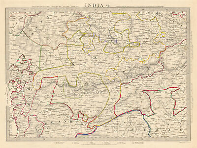
$10.04 Shipping Condition: Unspecified Location: LONDON, United Kingdom INDIA. VI. Bundelcund to Khandeish and Berar Antique steel engraved map with original outline hand colouring(coloring) 1844 Title of map: INDIA. VI. Bundelcund ... moreto Khandeish and Berar' The image below shows an enlarged cross section from the centre of the map to show the level of printed detail: DATE PRINTED: This map was originally published by Baldwin& Cradock in 1833; this date is printed on the map. This edition of the map was printed and published by Chapman& Hall in 1844. IMAGE SIZE: Approx 28.0 x 38.0cm. 11 x 15 inches(Large) ARTIST/CARTOGRAPHER/ENGRAVER: Engraved by J& C Walker PROVENANCE: Maps of the Society for the Diffusion of Useful Knowledge" Published by Chapman& Hall, London, under the superintendance of the Society for the Diffusion of Useful Knowledge TYPE: Antique steel engraved map with original outline hand colouring(coloring) VERSO: There is nothing printed on the reverse side. Which is plain CONDITION: Good; suitable for framing. Please check the scan for any blemishes prior to making your purchase. Virtually all antiquarian maps and prints are subject to some normal aging due to use and time which is not obtrusive unless otherwise stated. I offer a no questions asked return policy- see below. AUTHENTICITY: This is an authentic historic print. Published at the date stated above. I do not offer reproductions. It is not a modern copy. The term'original' when applied to a print means that it was printed at the first or original date of publication; it does not imply that the item is unique. Print' means any image created by applying an inked block to paper or card under pressure by any method including wood engraving, steel engraving, copperplate, wood cut and lithography. REMARKS: FRANCE: Gravures et Cartes anciennes. DEUTSCHLAND: Alte Lankarten und Stadt ansichten. ITALIA: Stampe e Mappe antiche. ESPAÑA: Mapas antiquos y impresiones antiguas. E and OE. Force Majeure. English law shall apply. RETURNS POLICY: I offer a no questions returns policy. All I
Buy It Now
$10.04 Shipping Condition: Unspecified Location: LONDON, United Kingdom PROVENANCE: Faden's "General Atlas". 'Northern Hemisphere'. Title of map:'Northern Hemisphere'. Large antique atlas map, printed on thick, good quality ... morepaper with original hand colour/color, 1802. DATE PRINTED: 1802.
Buy It Now
$10.04 Shipping Condition: Used Location: LONDON, United Kingdom Antique engraved atlas map with original hand colour/color, 1860. DATE PRINTED: 1860. TYPE: Antique engraved atlas map with original hand colour/color. ... moreAUTHENTICITY: This is an authentic historic print, published at the date stated above.
Buy It Now
$10.04 Shipping Condition: Used Location: LONDON, United Kingdom PROVENANCE: "Atlas de La France Vinicole. Les Vins de Champagne", L Larmat, Paris. Special edition for Maison Mumm [Larmat - Les Vins de Champagne]. This ... moredetailed map shows the communes and Champagne vineyards north west and south west of Reims.
Buy It Now
$10.04 Shipping Condition: Used Location: LONDON, United Kingdom Antique engraved atlas map with original hand colour/color, 1860. DATE PRINTED: 1860. TYPE: Antique engraved atlas map with original hand colour/color.
Buy It Now
$10.04 Shipping Condition: Unspecified Location: LONDON, United Kingdom Antique engraved map by J Rapkin, published by John Tallis. Original outline hand colour, decorative border, and attractive inset vignette views, 1851. ... morePublished by John Tallis & Co. TYPE: Antique engraved map by J Rapkin, published by John Tallis.
Buy It Now
$14.99 Shipping Location: Ivanhoe, Australia This beautifully hand coloured original antique Atlas Title Page published by Jan Jansson for the in the 1653 Spanish edition of Jansson's German/Netherlands ... moreAtlas. Jansson, Jan (Janssonius) 1588-1664.
Buy It Now
$11.95 Shipping Location: Swampscott, United States
Buy It Now
$10.04 Shipping Condition: Unspecified Location: LONDON, United Kingdom 'Herefordshire'. Caption below picture:'Herefordshire'. Antique steel engraved map with original hand colour, 1870. DATE PRINTED: 1870. TYPE: Antique ... moresteel engraved map with original hand colour.
Buy It Now
$10.04 Shipping Condition: Unspecified Location: LONDON, United Kingdom Antique steel engraved map with original outline hand colouring (coloring), 1844. This edition of the map was printed and published by Chapman & Hall ... morein 1844. Title of map:'SPAIN AND PORTUGAL, Modern'.
Buy It Now
$10.04 Shipping Condition: Unspecified Location: LONDON, United Kingdom Coloured in pink are the United States of the Ionian Islands as a separate entity from Greece and Turkey, a state and amical protectorate of the United ... moreKingdom that existed between 1815 and 1864. It covered the territory of the Ionian Islands, located in modern Greece, to whom it was ceded as a gift of the United Kingdom to the newly enthroned King George I, at the end of the protectorate.

Buy It Now
$10.04 Shipping Condition: Unspecified Location: LONDON, United Kingdom Western Africa Antique engraved map by J Rapkin. Published by John Tallis. Original outline hand colour, decorative border, and attractive inset vignette ... moreviews, 1851 Title of map: Western Africa' The image below shows an enlarged cross section from the centre of the map to show the level of printed detail: The map shows sub-saharan west Africa prior to the later"Scramble for Africa" colonisation. Senegambia is shown. As is the state of Liberia. Ashantee(roughly present day Ghana) is indicated. The coasts are evocatively named in turn as the"Grain coast" Windy coast" Ivory Coast" Gold Coast" Slave coast" Saharan camel caravan routes are indicated. Vignettes: Christiansborg; Cape Coast Castle; Bakel; Sierra Leone. Marked on the map are the Mountains of Kong, a non-existent mountain range charted on English maps of Africa from 1798 through the late 1880s. An early map resulting from exploration of the area and showing this west to east mountain range in 1798 was produced by English cartographer James Rennell. The mountains were thought to begin in West Africa near the highland source of the Niger River near Tembakounda in Guinea, then continue east to the also fictitious Central African Mountains of the Moon, thought to be where the White Nile rose. Cartographers stopped including the mountains on maps after French explorer Louis Gustave Binger established that the mountains were fictitious in his 1887-1889 expedition to chart the Niger River from its mouth in the Gulf of Guinea and through Côte d'Ivoire. DATE PRINTED: 1851 IMAGE SIZE: Approx 36.5 x 26.5cm. 14.5 x 10.25 inches(Large) ARTIST/CARTOGRAPHER/ENGRAVER: Map drawn and engraved by J. Rapkin; vignette illustrations drawn by H Winkles& engraved by E Radclyffe. Published by John Tallis& Co PROVENANCE: Tallis's Illustrated Atlas and Modern History of the World. Geographical, Political, Commercial and Statistical" edited by R Montgomery Martin Esq. published by John Tallis and Company, London&a

Buy It Now
$10.04 Shipping Condition: Unspecified Location: LONDON, United Kingdom CENTRAL AMERICA. SHEET I. INCLUDING YUCATAN, BELIZE, GUATEMALA, SALVADOR, HONDURAS, NICARAGUA AND THE SOUTHERN STATES OF MEXICO Antique steel engraved ... moremap with original outline hand colouring(coloring) 1844 Title of map: CENTRAL AMERICA. SHEET I. INCLUDING YUCATAN, BELIZE, GUATEMALA, SALVADOR, HONDURAS, NICARAGUA AND THE SOUTHERN STATES OF MEXICO' The image below shows an enlarged cross section from the centre of the map to show the level of printed detail: DATE PRINTED: This map was originally published by Chapman& Hall in 1842; this date is printed on the map. This edition of the map was printed and published by Chapman& Hall in 1844. IMAGE SIZE: Approx 33.0 x 40.0cm. 13 x 15.75 inches(Large) ARTIST/CARTOGRAPHER/ENGRAVER: Engraved by J& C Walker PROVENANCE: Maps of the Society for the Diffusion of Useful Knowledge" Published by Chapman& Hall, London, under the superintendance of the Society for the Diffusion of Useful Knowledge TYPE: Antique steel engraved map with original outline hand colouring(coloring) VERSO: There is nothing printed on the reverse side. Which is plain CONDITION: Good; suitable for framing. Please check the scan for any blemishes prior to making your purchase. Virtually all antiquarian maps and prints are subject to some normal aging due to use and time which is not obtrusive unless otherwise stated. I offer a no questions asked return policy- see below. AUTHENTICITY: This is an authentic historic print. Published at the date stated above. I do not offer reproductions. It is not a modern copy. The term'original' when applied to a print means that it was printed at the first or original date of publication; it does not imply that the item is unique. Print' means any image created by applying an inked block to paper or card under pressure by any method including wood engraving, steel engraving, copperplate, wood cut and lithography. REMARKS: FRANCE: Gravures et Cartes anciennes. DEUTSCHLAND: Alte Lankarten und Stadt ansichten. ITALIA: Stampe e Mappe antich
Buy It Now
$10.04 Shipping Condition: New Location: LONDON, United Kingdom Antique map with original outline colour, 1863. DATE PRINTED: 1863. The image below shows an enlarged cross section from the centre of the map to show ... morethe level of printed detail CONDITION: Good; suitable for framing.
Buy It Now
$10.04 Shipping Condition: Unspecified Location: LONDON, United Kingdom Antique steel engraved map with original outline hand colouring (coloring), 1844. This edition of the map was printed and published by Charles Knight ... morein 1844. 'EASTERN SIBERIA'. Caption below picture:'EASTERN SIBERIA'.
Buy It Now
$10.04 Shipping Condition: Used Location: LONDON, United Kingdom Antique map with original outline colour, 1863. DATE PRINTED: 1863. CONDITION: Good; suitable for framing. The map you will receive is in good condition ... morebut there may be minor variations in the condition from that shown in the image.
Buy It Now
$10.04 Shipping Condition: Unspecified Location: LONDON, United Kingdom 'Colonies Fran�aises (en Am�rique)'. Caption below picture:'Colonies Fran�aises (en Am�rique)'. Wide margins, 1856. DATE PRINTED: 1856. CONDITION: Good; ... moresuitable for framing. The map you will receive is in good condition but there may be minor variations in the condition from that shown in the image.
Buy It Now
$10.04 Shipping Condition: Unspecified Location: LONDON, United Kingdom Antique map with original outline colour, 1863. DATE PRINTED: 1863. Title of map:'Ireland North West sheet'. 'Ireland North West sheet'. CONDITION: Good; ... moresuitable for framing. The colouring used varies slightly between different examples of the map; the colouring applied to the map you receive may differ slightly from that shown in the image.
Buy It Now
$10.04 Shipping Condition: Unspecified Location: LONDON, United Kingdom PROVENANCE: "Atlas Universel de Geographie Ancienne et Moderne", Par M. Lapie et M. Lapie Fils. D�di� au Roi. CONDITION: Good; suitable for framing. Large ... more(folio) antique atlas map with original hand colour, 1832.
Buy It Now
$33.88 Shipping Condition: Unspecified Location: LONDON, United Kingdom Antique steel engraved map with original outline hand colouring (coloring), 1844. This edition of the map was printed and published by Charles Knight ... morein 1844. Caption below picture:'THE ISLANDS OF NEW ZEALAND.'.
Buy It Now
$10.04 Shipping Condition: Unspecified Location: LONDON, United Kingdom The map shows the "Colonies of Poles and Germans" within Bessarabia. Antique steel engraved map with original outline hand colouring (coloring), 1844. ... moreDATE PRINTED: This map was originally published by Baldwin & Cradock in 1835; this date is printed on the map.
Buy It Now
$27.60 Shipping Condition: Unspecified Location: LONDON, United Kingdom Robert de Vaugondy, fils de Mr. Robert Géogr. Avec Privilege'. PROVENANCE: "Atlas Universel" par M. Robert, Geographe ordinaire du Roy et par M. Robert ... morede Vaugondy son fils Geographe ord. du Roy et de S. M. Polonaise Duc de Lorraine et de Bar, et Associe de l'Academie Royale des Sciences et belles letters de Nancy.
Buy It Now
$10.04 Shipping Condition: Unspecified Location: LONDON, United Kingdom Antique steel engraved map with original outline hand colouring (coloring), 1844. DATE PRINTED: This map was originally published by Baldwin & Cradock ... morein 1829; this date is printed on the map. This edition of the map was printed and published by Charles Knight in 1844.
Buy It Now
$10.04 Shipping Condition: Unspecified Location: LONDON, United Kingdom Title of map:'Jura'. Antique engraved map with original outline colour, 1823. DATE PRINTED: 1823. CONDITION: Good; suitable for framing. The colouring ... moreused varies slightly between different examples of the map; the colouring applied to the map you receive may differ slightly from that shown in the image.

Buy It Now
$10.04 Shipping Condition: Unspecified Location: LONDON, United Kingdom Cabool. The Punjab and Beloochistan Antique engraved map by J Rapkin. Published by John Tallis. Original outline hand colour, decorative border, and attractive ... moreinset vignette views, 1851 Title of map: Cabool. The Punjab and Beloochistan' The image below shows an enlarged cross section from the centre of the map to show the level of printed detail: The map covers modern Pakistan. Afghanistan, and part of India. Vignettes: Boats on the Indus; Sultan Mahmoud's Minars and Fortress- Ghuznef. Afghanistan. Lahore& Amritsar are marked. DATE PRINTED: 1851 IMAGE SIZE: Approx 36.5 x 26.5cm. 14.5 x 10.25 inches(Large) ARTIST/CARTOGRAPHER/ENGRAVER: Map drawn and engraved by J. Rapkin; vignette illustrations drawn by A Fussell& engraved by JB Allen. Published by John Tallis& Co PROVENANCE: Tallis's Illustrated Atlas and Modern History of the World. Geographical, Political, Commercial and Statistical" edited by R Montgomery Martin Esq. published by John Tallis and Company, London& New York. Please note that virtually all antique and vintage maps and prints have been extracted from books, atlases or newspapers. TYPE: Antique engraved map by J Rapkin. Published by John Tallis. Original outline hand colour, decorative border, and attractive inset vignette views VERSO: There is nothing printed on the reverse side. Which is plain CONDITION: Fair-to-Good: Spotting; The map has not been trimmed but title at the top has been printed right up to the edge of the page. Tight top margin. Please note any other blemishes on the scan prior to purchasing this picture. Virtually all antiquarian maps and prints are subject to some normal aging due to use and time which is not obtrusive unless otherwise stated. I offer a no questions asked return policy- see below. AUTHENTICITY: This is an authentic historic print. Published at the date stated above. I do not offer reproductions. It is not a modern copy. The term'original' when applied to a print means that it was printed at the first or original date of p
Buy It Now
$10.04 Shipping Condition: Unspecified Location: LONDON, United Kingdom 'Lincolnshire'. Title of map:'Lincolnshire'. Antique map with original outline colour, 1863. DATE PRINTED: 1863. CONDITION: Good; suitable for framing. ... moreThe colouring used varies slightly between different examples of the map; the colouring applied to the map you receive may differ slightly from that shown in the image.
Buy It Now
$11.00 Shipping Location: Rockville, United States Large with hand colored outlines.
Buy It Now
$11.00 Shipping Location: Rockville, United States Large with hand colored outlines.
|
|
|
In
|
Johnson's Family Atlas NORTH & SOUTH CAROLINA Civil War hand-colored MAP 1864
Genuine hand-colored MAP Johnson's Family Atlas 1864 North and South Carolina Sheet dimensions: 18 x 26.5 inches Good condition. Overall clean. Scattered minor spot or two, but overall a very presentable and attractive map Maps mailed in cardboard tubes Combined shipping at no additional charge Powered by The free listing tool. List your items fast and easy and manage your active items.
|
|
|
1874 NORTH SOUTH CAROLINA VIRGINIA Map COLTON ATLAS Hand Watercolored Original
An ORIGINAL antique color map of NORTH CAROLINA. SOUTH CAROLINA, VIRGINIA, WEST VIRGINIA, and MARYLAND from Colton's Common School Geography Atlas. The counties are individually hand watercolored and hundreds of towns and railroads are shown. A map of NEW YORK and PENNSYLVANIA is on the reverse side. The map measures 10 by 12 inches. This ORIGINAL antique map is guaranteed over 130 years old. The copyright date 1874 is printed along the lower border of the map. I do not sell reproductions. Just honest maps at honest prices. Discounted shipping too. NO International shipping. NO exceptions. All items shipped within 2 business days after payment. If you have not received an item in a reasonable amount of time please email me. It has been delayed by the Post Office. I also accept returns on ANY item for ANY reason, please email me I am very ... moreeasy to work with. Feedback is not the same thing as an email, please email first. On Oct-19-07 at 13:06:06 PDT. Seller added the following information: di,RcmdId ViewItemDescV4,RlogId p4%60bo7%60jtb9%3Fuk%601d72f%2Bishhov%3C%3Edi-13f2fe73342-0xf1-
|
|
|
1864 ALABAMA GEORGIA Map JOHNSON ATLAS CIVIL WAR Hand Watercolor
An ORIGINAL antique 1864 map of ALABAMA and GEORGIA from JOHNSON'S New Illustrated FAMILY ATLAS. The counties are individually HAND WATERCOLORED and a number of early railroads are shown with their names printed next to them. What makes Johnson's maps so desirable is that although many maps from this time period showed railroad routes. His also show major stagecoach and wagon roads. This map shows hundreds of these roads. Among the finest maps produced during the 19th Century. Johnson's maps were used extensively during the Civil War. The map measures 26 by 18 inches and is perfect for matting and framing. This ORIGINAL antique map is guaranteed over 145 years old, published during the CIVIL WAR. I do not sell reproductions, just honest maps at honest prices. Discounted shipping too. NO international shipping. NO exceptions. All ... moreitems shipped within 2 business days after payment. If you have not received an item in a reasonable amount of time please email me. It has been delayed by the Post Office. I also accept returns on ANY item for ANY reason, please email me I am very easy to work with. Feedback is not the same thing as an email, please email first. On Oct-19-07 at 13:06:06 PDT. Seller added the following information:
|
|
|
1873 ALABAMA FLORIDA GEORGIA Map COLTON ATLAS Hand Watercolored Original
An ORIGINAL antique color map of ALABAMA. FLORIDA, and GEORGIA from Colton's Common School Geography Atlas. The counties are individually hand watercolored and hundreds of towns and railroads are shown. This rare map shows Birmingham for the first time in the year it was founded in 1873. It also shows the town of ELYTON next to Birmingham which preceded it. The map measures 10 by 12 inches. This ORIGINAL antique map is guaranteed over 130 years old. The copyright date 1873 is printed along the lower border of the map. I do not sell reproductions. Just honest maps at honest prices. Discounted shipping too. NO International shipping. NO exceptions. All items shipped within 2 business days after payment. If you have not received an item in a reasonable amount of time please email me. It has been delayed by the Post Office. I also accept ... morereturns on ANY item for ANY reason, please email me I am very easy to work with. Feedback is not the same thing as an email, please email first. On Oct-19-07 at 13:06:06 PDT. Seller added the following information:
|
|
|
1862 ALABAMA GEORGIA Map JOHNSON ATLAS CIVIL WAR Hand Watercolor
An ORIGINAL antique 1862 map of ALABAMA and GEORGIA from JOHNSON'S New Illustrated FAMILY ATLAS. The counties are individually HAND WATERCOLORED and a number of early railroads are shown with their names printed next to them. What makes Johnson's maps so desirable is that although many maps from this time period showed railroad routes. His also show major stagecoach and wagon roads. This map shows hundreds of these roads. There are 2 engraved vignettes that show the TUSCALOOSA OBSERVATORY and a RICE MILL ON THE SAVANNAH at the corners. Among the finest maps produced during the 19th Century. Johnson's maps were used extensively during the Civil War. The map measures 26 by 18 inches and is perfect for matting and framing. This ORIGINAL antique map is guaranteed over 150 years old, published during the CIVIL WAR. I do not sell reproductions, ... morejust honest maps at honest prices. Discounted shipping too. NO international shipping. NO exceptions. All items shipped within 2 business days after payment. If you have not received an item in a reasonable amount of time please email me. It has been delayed by the Post Office. I also accept returns on ANY item for ANY reason, please email me I am very easy to work with. Feedback is not the same thing as an email, please email first. On Oct-19-07 at 13:06:06 PDT. Seller added the following information:
|
|
|
1880 NORTH SOUTH CAROLINA VIRGINIA Map MITCHELL ATLAS Hand Colored Original!!
An ORIGINAL antique map of NORTH and SOUTH CAROLINA. VIRGINIA, and WEST VIRGINIA from Mitchell's New Intermediate Geography Atlas, 1880. The States are individually hand water colored and dozens of early railroads from the time period are shown. The map measures 9 1/2 by 12 inches. This ORIGINAL antique map is guaranteed over 130 years old. I do not sell reproductions. Just honest maps at honest prices. Discounted shipping too. NO International shipping. NO exceptions. All items shipped within 2 business days after payment. If you have not received an item in a reasonable amount of time please email me. It has been delayed by the Post Office. I also accept returns on ANY item for ANY reason, please email me I am very easy to work with. Feedback is not the same thing as an email, please email first. On Oct-19-07 at 13:06:06 PDT. Seller ... moreadded the following information: jy.RcmdId ViewItemDescV4,RlogId p4%60bo7%60jtb9%3Fuk%601d72f%2Bkw4sjm5%3Ejy-14186ff7c8e-0xf3-
|
|
|
1865 ALABAMA GEORGIA Map JOHNSON ATLAS CIVIL WAR Hand Watercolor
An ORIGINAL antique 1865 map of ALABAMA and GEORGIA from JOHNSON'S New Illustrated FAMILY ATLAS. The counties are individually HAND WATER COLORED and a number of early railroads are shown with their names printed next to them. What makes Johnson's maps so desirable is that although many maps from this time period showed railroad routes. His also show major stagecoach and wagon roads. This map shows hundreds of these roads. Among the finest maps produced during the 19th Century. Johnson's maps were used extensively during the Civil War. The map measures 26 by 18 inches and is perfect for matting and framing. This ORIGINAL antique map is guaranteed over 145 years old, published during the CIVIL WAR. I do not sell reproductions, just honest maps at honest prices. Discounted shipping too. NO international shipping. NO exceptions. ... moreAll items shipped within 2 business days after payment. If you have not received an item in a reasonable amount of time please email me. It has been delayed by the Post Office. I also accept returns on ANY item for ANY reason, please email me I am very easy to work with. Feedback is not the same thing as an email, please email first. On Oct-19-07 at 13:06:06 PDT. Seller added the following information:
|
|
|
J.H. Colton, hand tinted MAP OF FLORIDA, 1855, from atlas
Approx. 15-1/2 x 18 inches; 11 x 14 inches within the decorative borders. If upon receiving the item. You feel it does not completely match the description, you may return it within 14 days for a complete refund. Shipping can be combined for multiple postcard and small paper orders. No international shipping for this item.
|
|
|
1890 MISSISSIPPI STATE MAP WITH RAILROADS HAND-COLORED ATLAS MAP
TITLE MISSISSIPPI DATED 1890 ISSUED BY RAND MCNALLY AND COMPANY HAND-COLORED MAP OF THE STATE OF MISSISSIPPI SHOWING ALL RAILROAD ROUTES. TOWNSHIPS AND WATERWAYS. MEASURES 12 X 9 INCHES GOOD CONDITION
|
|
|
1868 ALABAMA GEORGIA Map JOHNSON ATLAS CIVIL WAR Hand Watercolor
An ORIGINAL antique 1868 map of ALABAMA and GEORGIA from JOHNSON'S New Illustrated FAMILY ATLAS. The counties are individually HAND WATER COLORED and a number of early railroads are shown with their names printed next to them. What makes Johnson's maps so desirable is that although many maps from this time period showed railroad routes. His also show major stagecoach and wagon roads. This map shows hundreds of these roads. Among the finest maps produced during the 19th Century. Johnson's maps were used extensively during the Civil War. The map measures 26 by 18 inches and is perfect for matting and framing. This ORIGINAL antique map is guaranteed over 145 years old, published just after the CIVIL WAR. I do not sell reproductions, just honest maps at honest prices. Discounted shipping too. NO international shipping. NO exceptions. ... moreAll items shipped within 2 business days after payment. If you have not received an item in a reasonable amount of time please email me. It has been delayed by the Post Office. I also accept returns on ANY item for ANY reason, please email me I am very easy to work with. Feedback is not the same thing as an email, please email first. On Oct-19-07 at 13:06:06 PDT. Seller added the following information:
|
|
|
1868 NORTH SOUTH CAROLINA Map JOHNSON ATLAS CIVIL WAR Hand Watercolor
An ORIGINAL antique 1868 map of NORTH and SOUTH CAROLINA from JOHNSON'S New Illustrated FAMILY ATLAS. The counties are individually hand water colored and a number of early railroads are shown with their names printed next to them. Two engraved vignettes show TABLE MOUNTAIN and CHIMNEY ROCKS. What makes Johnson's maps so desirable is that although many maps from this time period showed railroad routes. His also show major stagecoach and wagon roads. This map shows hundreds of these roads. Among the finest maps produced during the 19th Century. Johnson's maps were used extensively during the Civil War. The map measures 26 by 18 inches and is perfect for matting and framing. This ORIGINAL antique map is guaranteed over 145 years old, published just after the CIVIL WAR. I do not sell reproductions, just honest maps at honest prices. ... moreDiscounted shipping too. NO international shipping. NO exceptions. All items shipped within 2 business days after payment. If you have not received an item in a reasonable amount of time please email me. It has been delayed by the Post Office. I also accept returns on ANY item for ANY reason, please email me I am very easy to work with. Feedback is not the same thing as an email, please email first. On Oct-19-07 at 13:06:06 PDT. Seller added the following information:
|
|
|
1855 SOUTHERN STATES Hand Colored MAP - PARLEY ATLAS- AL AR GA KY LA MS NC SC VA
Antique HandColored Map 1 FULL Page Removed From Antique Atlas( NOT a Reproduction/ Facsimile) = NO REPRO Please View the 3 Images BELOW Region: Southern States States: Alabama Arkansas Georgia Kentucky Louisiana Mississippi North Carolina South Carolina Virginia Size of Entire Page: 5.25 x 7 inches Size of Rectangular MAP AREA: 4.33 x 6. 11 inches Source: Atlas: Parley's First Book of History Co mbin ed with Geograp hy Cartographer: Peter Parley Publisher: Hickling Swan and Brown/ Boston MA Date ATLAS Published: 1855 Plate Number: n/a Verso/ Back of Page: BLANK FLAWS NOT Visible in the Image Below: three small holes along edge where removed from atlas in Margin ONLY NOTE: Item You Will Receive is an Entir e Page Ready to be Framed and/or Matted Fine Print: USPS Shipping Fees( First Class/ Priority Mail) Can Be Calculated Above. will ... moreCOMBINE Shipments Whenever Possible to Reduce Shipping Fee) Insurance Available AT COST- Please Let Us Know IF Desired. NO Handling Fees and QUICK Handling Time! SAFE Packaging. We Accept PayPal ONLY. Mass. Residents MUST Add 6.25% Sales Tax. Do NOT Ship Any Items Outside the U.S.A. this includes APOs/FPOs. NOTES: Scans and Photos Below are of the EXACT Item(s) You Will Receive Safe Packaging = 4 mil. Plastic Sleeve Surrounded by Cardboard in a Thick Kraft Envelope with a"Do Not Bend" Sticker. Auctions: Will Not End Early Buy It Now Items: Will Not Entertain Offers(Unless"Best Offer" Link Present) Have Been Selling on eBay Since 2004 View the other Vintage and Antique Images in our eBay Store by Clicking on the Link Below: The Paper Merchant eBay Store Thanks For Looking! Sca n is of the EXACT Item You Will Receive PhotoCopy of Title Pages BELOW Included with THIS Lot keywords: antique map. Antique maps, antique atlas, antique atlases, antique plate, antique plates, antique engraving, antique engravings, antique steel engraving, antique steel engravings, + antique parley map, antique parley maps, antique parley atlas, antique parley atlases, antique parley
|
|
|
1866 ALABAMA GEORGIA Map JOHNSON ATLAS CIVIL WAR Hand Watercolor
An ORIGINAL antique 1866 map of ALABAMA and GEORGIA from JOHNSON'S New Illustrated FAMILY ATLAS. The counties are individually HAND WATER COLORED and a number of early railroads are shown with their names printed next to them. What makes Johnson's maps so desirable is that although many maps from this time period showed railroad routes. His also show major stagecoach and wagon roads. This map shows hundreds of these roads. Among the finest maps produced during the 19th Century. Johnson's maps were used extensively during the Civil War. The map measures 26 by 18 inches and is perfect for matting and framing. This ORIGINAL antique map is guaranteed over 145 years old, published just after the CIVIL WAR. I do not sell reproductions, just honest maps at honest prices. Discounted shipping too. NO international shipping. NO exceptions. ... moreAll items shipped within 2 business days after payment. If you have not received an item in a reasonable amount of time please email me. It has been delayed by the Post Office. I also accept returns on ANY item for ANY reason, please email me I am very easy to work with. Feedback is not the same thing as an email, please email first. On Oct-19-07 at 13:06:06 PDT. Seller added the following information:
|
|
|
1867 ALABAMA GEORGIA Map JOHNSON ATLAS CIVIL WAR Hand Watercolor
An ORIGINAL antique 1867 map of ALABAMA and GEORGIA from JOHNSON'S New Illustrated FAMILY ATLAS. The counties are individually HAND WATER COLORED and a number of early railroads are shown with their names printed next to them. What makes Johnson's maps so desirable is that although many maps from this time period showed railroad routes. His also show major stagecoach and wagon roads. This map shows hundreds of these roads. Among the finest maps produced during the 19th Century. Johnson's maps were used extensively during the Civil War. The map measures 26 by 18 inches and is perfect for matting and framing. This ORIGINAL antique map is guaranteed over 145 years old, published just after the CIVIL WAR. I do not sell reproductions, just honest maps at honest prices. Discounted shipping too. NO international shipping. NO exceptions. ... moreAll items shipped within 2 business days after payment. If you have not received an item in a reasonable amount of time please email me. It has been delayed by the Post Office. I also accept returns on ANY item for ANY reason, please email me I am very easy to work with. Feedback is not the same thing as an email, please email first. On Oct-19-07 at 13:06:06 PDT. Seller added the following information:
|
|
|
1866 NORTH SOUTH CAROLINA Map JOHNSON ATLAS CIVIL WAR Hand Watercolor
An ORIGINAL antique 1866 map of NORTH and SOUTH CAROLINA from JOHNSON'S New Illustrated FAMILY ATLAS. The counties are individually hand water colored and a number of early railroads are shown with their names printed next to them. Two engraved vignettes show TABLE MOUNTAIN and CHIMNEY ROCKS. What makes Johnson's maps so desirable is that although many maps from this time period showed railroad routes. His also show major stagecoach and wagon roads. This map shows hundreds of these roads. Among the finest maps produced during the 19th Century. Johnson's maps were used extensively during the Civil War. The map measures 26 by 18 inches and is perfect for matting and framing. This ORIGINAL antique map is guaranteed over 145 years old, published just after the CIVIL WAR. I do not sell reproductions, just honest maps at honest prices. ... moreDiscounted shipping too. NO international shipping. NO exceptions. All items shipped within 2 business days after payment. If you have not received an item in a reasonable amount of time please email me. It has been delayed by the Post Office. I also accept returns on ANY item for ANY reason, please email me I am very easy to work with. Feedback is not the same thing as an email, please email first. On Oct-19-07 at 13:06:06 PDT. Seller added the following information: 1?RcmdId ViewItemDescV4,RlogId p4%60bo7%60jtb9%3Feog4d72f%2B%3E%3B1%3F-1440a39fba7-0xdb-
|
|
|
LARGE ORIGINAL 1857 MISSISSIPPI MAP FROM COLTON US ATLAS HAND COLORED
Antique map from Colton's Atlas of America. 1857 Original 157 year old antique map from Colton's Atlas of America. The scarce advertising atlas with numerous full and half page advertisements in addition to the maps. We purchased the atlas as a partial one with some of the advertisements removed. We've included an image of the title page(not included as part of this auction) below, just for informational purposes. The overall size of the page is an impressive 18.5" x 16" The map was printed and then hand watercolored to show the various counties and other divisions. It provides a fascinating snapshot view of the area's geographical details at the time of publication 157 years ago. Condition is very good. And much nicer than the image would suggest. There is some modest age-darkening around the edges, otherwise the ... moremap is very clean. There are a few light shadows lettering from the advertisement that was on its opposite page at one time. Barely visible. The reverse side is blank. See the image for condition details. But frankly, the image really doesn't do it any justice. We are/will be offering many of these maps on eBay. As well as some of the better advertisements. They will all be offered at low opening bids with no reserves. These are all genuine items, not cheesy reproductions or reprints. Please visit our other listings to view them. Free Priority shipping in the United States. Due to their size. These maps will be carefully rolled, wrapped in plastic, and mailed in a tube. We have been shipping books and other items for 17 years, so we have learned to pack carefully and safely. If you plan to purchase more than one of these maps or other items. Please do not pay until you're done bidding. We'd prefer to ship them together. Reminder: the image of the title page below is for informational purposes only- it is NOT included as part of this auction. And please do not ask for photocopies of it since it's just so darn big. Thanks for your interest. And happy bidding!
|
|
|
1887 SOUTHERN STATES WITH RAILROAD ROUTES COWPERTHWAIT ATLAS MAP HAND COLORED
ORIGINAL 1887 COWPERTHWAIT MAP OF THE SOUTHERN STATES DATE 1887 ISSUED BY COWPERTHWAIT FROM WARREN'S COMMON SCHOOL ATLAS THIS AUCTION IS FOR AN ORIGINAL MAP FROM 1887 FROM WARREN'S SCHOOL ATLAS. MAP SHOWS THE SOUTHERN STATES OF THE U.S. WITH RAILROAD ROUTES AND MANY TOWNSHIPS. MEASURES 10 X 11.5 INCHES FAIR CONDITION. MINOR DISCOLORATION
|
|
|
1866 FLORIDA Map JOHNSON ATLAS CIVIL WAR Hand Watercolor
An ORIGINAL antique 1866 map of FLORIDA from JOHNSON'S New Illustrated FAMILY ATLAS. The counties are individually hand water colored and a number of early railroads are shown with their names printed next to them. Only a State for 20 years at the time. The southern half was still largely inhabited only by the Army and Seminole Indians. What makes Johnson's maps so desirable is that although many maps from this time period showed railroad routes. His also show major stagecoach and wagon roads. This map shows hundreds of these roads. Among the finest maps produced during the 19th Century. Johnson's maps were used extensively during the Civil War. The map measures 14 by 18 inches and is perfect for matting and framing. This ORIGINAL antique map is guaranteed over 145 years old, published just after the CIVIL WAR. I do not sell reproductions, ... morejust honest maps at honest prices. Discounted shipping too. NO international shipping. NO exceptions. All items shipped within 2 business days after payment. If you have not received an item in a reasonable amount of time please email me. It has been delayed by the Post Office. I also accept returns on ANY item for ANY reason, please email me I am very easy to work with. Feedback is not the same thing as an email, please email first. On Oct-19-07 at 13:06:06 PDT. Seller added the following information:
|
|
|
1861 Johnson Atlas Hand Colored Map of GEORGIA & ALABAMA * Original! #8a
1861 Johnson Atlas Hand Colored Print of WORLD MOUNTAINS* Original Antique! This beautiful map is from the famous Johnson Family Atlas with original hand coloring. Johnson was one of the two premium American map publishers of the era from 1860 to 1885. They are renown for their Civil War era maps. This is an original antique. NOT a reproduction and guaranteed to be over 150 years old. Size: Sheet size of print is 18" x 26" or 46cm x 66cm. Please click on my"ME" page to learn more about us. Looking for additional quality items? Check out our other auctions for more that we have listed on eBay! Powered by The free listing tool. List your items fast and easy and manage your active items.
|
|
|
1868 FLORIDA Map JOHNSON ATLAS CIVIL WAR Hand Watercolor
An ORIGINAL antique 1868 map of FLORIDA from JOHNSON'S New Illustrated FAMILY ATLAS. The counties are individually hand water colored and a number of early railroads are shown with their names printed next to them. Only a State for 20 years at the time. The southern half was still largely inhabited only by the Army and Seminole Indians. What makes Johnson's maps so desirable is that although many maps from this time period showed railroad routes. His also show major stagecoach and wagon roads. This map shows hundreds of these roads. Among the finest maps produced during the 19th Century. Johnson's maps were used extensively during the Civil War. The map measures 14 by 18 inches and is perfect for matting and framing. This ORIGINAL antique map is guaranteed over 145 years old, published just after the CIVIL WAR. I do not sell reproductions, ... morejust honest maps at honest prices. Discounted shipping too. NO international shipping. NO exceptions. All items shipped within 2 business days after payment. If you have not received an item in a reasonable amount of time please email me. It has been delayed by the Post Office. I also accept returns on ANY item for ANY reason, please email me I am very easy to work with. Feedback is not the same thing as an email, please email first. On Oct-19-07 at 13:06:06 PDT. Seller added the following information:
|
|
|
1860 Blackie Atlas Hand Colored Map of Eastern United States * #088
1860 Blackie This beautiful map is from the Blackie Imperial Atlas with original hand coloring. They are known for their excellent detail and extensive coverage of the world. Published by Blackie and Son. London: 1860. This is an original antique. NOT a reproduction and guaranteed to be over 150 years old. Size: Sheet size is 14.5" x 21.5" or 37cm x 54cm. Please click on my"ME" page to learn more about us. Looking for additional quality items? Check out our other auctions for more that we have listed on eBay! Powered by The free listing tool. List your items fast and easy and manage your active items.
|
|
|
1884 FLORIDA ALABAMA GEORGIA CAROLINA Map WARREN ATLAS Hand Colored Original
An ORIGINAL antique map of the SOUTHERN STATES from NORTH CAROLINA to LOUISIANA from D. M. WARREN'S Common School Geography. 1884. The States are individually hand water colored and dozens of early railroads are shown. The map measures 9 1/2 by 12 inches. Published just 2 decades after the CIVIL WAR. This ORIGINAL antique map is guaranteed over 125 years old. I do not sell reproductions, just honest maps at honest prices. Discounted shipping too. NO International shipping. NO exceptions. All items shipped within 2 business days after payment. If you have not received an item in a reasonable amount of time please email me. It has been delayed by the Post Office. I also accept returns on ANY item for ANY reason, please email me I am very easy to work with. Feedback is not the same thing as an email, please email first. On Oct-19-07 at 13:06:06 ... morePDT. Seller added the following information:
|
|
|
1850 Hand Colored Mitchell Atlas Map MAP OF NORTH AMERICA 13x17"
i000000. 1850 Hand Colored Mitchell Atlas Map MAP OF NORTH AMERICA 13x17" MAP OF NORTH AMERICA(FROM NEW UNIVERSAL ATLAS OF THE WORLD) Cartographer: Samuel Augustus Mitchell Publisher: Thomas Cowperthwait& Co. Year: 1850 Size: 13.5" x 17.2" Details: Map is toned with a stain in the lower margin that runs into the border but otherwise clean and in very good condition. Hand colored. inkfrog terapeak. InkFrog Analytics.
|
|
|
1864 FLORIDA Map JOHNSON ATLAS CIVIL WAR Hand Watercolor
An ORIGINAL antique 1864 map of FLORIDA from JOHNSON'S New Illustrated FAMILY ATLAS. The counties are individually hand water colored and a number of early railroads are shown with their names printed next to them. South of Tampa there are virtually no settlements although there are a handful of wagon roads noted and 20 or so named Forts. Even these stop at the Everglades which are labelled"COUNTRY OCCUPIED BY THE SEMINOLES" and"INDIAN HUNTING GROUNDS" An 1863 copyright date is printed along the lower border. What makes Johnson's maps so desirable is that although many maps from this time period showed railroad routes. His also show major stagecoach and wagon roads. This map shows hundreds of these roads. Among the finest maps produced during the 19th Century. Johnson's maps were used extensively during the ... moreCivil War. The map measures 14 by 18 inches and is perfect for matting and framing. This ORIGINAL antique map is guaranteed over 145 years old, published during the CIVIL WAR. I do not sell reproductions, just honest maps at honest prices. Discounted shipping too. NO international shipping. NO exceptions. All items shipped within 2 business days after payment. If you have not received an item in a reasonable amount of time please email me. It has been delayed by the Post Office. I also accept returns on ANY item for ANY reason, please email me I am very easy to work with. Feedback is not the same thing as an email, please email first. On Oct-19-07 at 13:06:06 PDT. Seller added the following information:
|
|
|
ORIGINAL 1855 ALABAMA Atlas Map by Colton Hand-colored 17x14" Antique
ORIGINAL 1855 Atlas Map by Colton Hand-colored map of Alabama Totally originally. Not a copy or reproduction. Size: 16 3/4" by 13 3/4" Pay 5.00 postage or) pick up at the Missouri Mouse Antique shop in St Paul. Minnesota, at the Map and Local History Room. By appointment.
|
|
 |