Buy It Now
$4.95 Shipping Location: Dover, United States County Map of Nova Scotia, New Brunswick, Cape Breton Island, and Prince Edward Island. Issued 1874, Philadelphia by S.A. Mitchell. 19th century engraved ... moremap, with original hand color. Dictionary of Mapmakers, vol.
Buy It Now
$6.95 Shipping Location: Dover, United States Issued c. 1870's, Paris by Becquet. Engraved by S. Jacobs. Late 19th century lithographed historical map with original outline hand color.
Buy It Now
$6.95 Shipping Location: Dover, United States [Delagrave]. Lovely and uncommon early 19th century folio sheet antique map. Engraved with original hand color, piano key border. Original fold line as ... moreissued. Minor light offsetting, but overall clean and attractive.
Buy It Now
$6.95 Shipping Location: Dover, United States Issued c. 1863, Paris by Le Chevalier. Map by Dufour and Dyonnet. Oversized large folio sheet mid 19th century engraved map with original hand color. ... moreOriginal center fold as issued.
Buy It Now
$6.95 Shipping Location: Dover, United States Issued c. 1795-1806, Paris by Delamarche. Map by Vaugondy, revised and reissued by Delamarche. Engraved by Dussy. Late 18th/ early 19th century engraved ... moremap with original outline hand color. Dictionary of Mapmakers, vol.
Buy It Now
$6.95 Shipping Location: Dover, United States Uncommon late 19th century lithographed map, with original hand color. This late Mitchell map was issued by Bradley for a short period before disappearing ... morefrom publication. Issued c. 1886-8, Philadelphia by Bradley, successor to S.A. Mitchell.
Buy It Now
$6.95 Shipping Location: Dover, United States Issued 1842, Paris by Lapie. (Asia, Asia Minor, Anatolia, Lydia, Bithynia, Phrygia, Cappadocia, Pontus, Cyprus). Finely engraved large oversize mid-19th ... morecentury map with original outline hand color.
Buy It Now
$6.95 Shipping Location: Dover, United States Issued 1758, London. Engraved by Thomas Jefferys. Charming little mid-18th century antique map. Engraved with beautiful full hand color. Russia or Muscovy. ... moreSmall well done repair at top left graticule which is easy to forgive visually.
Buy It Now
$6.95 Shipping Location: Dover, United States Issued 1871, New York. by Hayward for Valentine. A Map of the Common Lands Between the Three and Six Mile Stones Belonging to the Corporation of the City ... moreof New York, 1796. Left blank edge uneven and slightly narrow as issued from inset tab.
Buy It Now
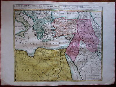
$11.85 Shipping Location: Dover, United States Carte Particuliere des Pais ou Les Apotres ont Preche l'Euan Gile; des Lieux les Plus Renommez de Leurs Voyages. Et de la Route de St. Paul a Rome. ... moreDressee pour bien entendre l'Histoire Sainte. Mediterranean. Arabia, Turkey, Greece, Armenia, North Africa) Issued Amsterdam. C. 1730-40 by Covens& Mortier. Fine mid-18th century engraved folio sheet map of the Mediterranean and Middle East. With original hand color. Quite interesting for the detailed depiction of Arabia. Armenia and Turkey during the time of the Apostles travels. In VG to near fine. Clean, well-preserved condition. A fine map. Sheet measures c. 24" W x 17" H. Printed area c. 18 1/4" W x 15" H. Folio. Tooleys Dictionary of Mapmakers. Vol. 1, p. 308. Marco van Egmond. Covens& Mortier. 3.3 R564. Everything we offer is guaranteed to be an authentic original antique item as described. We stand behind everything we sell. Important information for International Buyers* You may be charged customs. Taxes or other import duties by your country! this has nothing at all to do with us. Please do not hold us responsible if your Government wants to collect tax when you buy something outside of your country] Import duties. Taxes, and customs fees are not included in the item price or shipping cost. These charges are normally collected by the shipping service when the package is delivered or when you pick the item up. They are the buyer's responsibility and are not additional shipping charges. Please understand they have nothing to do with us and we have no control over them] Please check with your country's customs office to determine what these additional costs will be prior to bidding or buying. We do not know the various rules of your Customs office. There are a lot of countries in the world. Most with complex detailed variable laws in languages we don't read. Plus these laws are constantly being changed& revised] We won't under-value merchandise or mark the item as a gift on customs forms. Doing so is again
Buy It Now
$6.95 Shipping Location: Dover, United States Inspection for Committee on Charles River Dam. Issued 1902, Boston.
Buy It Now
$10.00 Shipping Location: Thailand
Buy It Now
$6.95 Shipping Location: Dover, United States Issued 1850, Paris. Engraved by Villerey. Mid 19th century engraved map with original hand color. Decorative vignettes greatly enhance visual appeal. ... moreAny age flaws mostly minor and easy to overlook or forgive.
Buy It Now
$6.95 Shipping Location: Dover, United States Issued 1851, Liverpool by George Philip & Son. Martinico, to France & Dominica, to Britain. (Caribbean islands- inset of Cul de Sac Royal). Fine and uncommon ... moremid-19th century engraved map with original hand color.
Buy It Now
$6.95 Shipping Location: Dover, United States (Asia, China, Qing Empire, Japan, Korea, Beijing, Peking, Canton, Hong Kong, Taiwan, Macao). Uncommon mid 19th century lithographed map with original ... morehand color. Inset of Vicinity of Canton and Hong Kong.
Buy It Now
$6.95 Shipping Location: Dover, United States Issued c. 1856-72, London by Edward Weller for the Weekly Dispatch Atlas. Mid 19th century lithographed map with original outline hand color. The apocryphal ... moreLake Torrens is shown with the incorrect hook shape in South Australia.
Buy It Now
$6.95 Shipping Location: Dover, United States Polen u. West Russland. Late 19th century color lithographed map.
Buy It Now
$6.95 Shipping Location: Dover, United States The Glaciers of South Eastern Alaska to Illustrate the Paper by Otto J. Klotz, Canadian Topographical Survey. Issued 1899, Edinburgh by W. & A.K. Johnston ... morefor the Royal Geographic Society. Scarce detailed 19th century color lithographed folding map issued in a geographical periodical, inherently scarce thus.
Buy It Now
$6.95 Shipping Location: Dover, United States Issued 1713, London by H. Moll. Charming early 18th century engraved miniature map with beautiful hand color. Moscovia or Russia Divided into its General ... moreParts &c. Original center fold as issued.
Buy It Now
$6.95 Shipping Location: Dover, United States Issued c. 1950, Paris. Map by Koch. Advertising on reverse.
Buy It Now
$75.00 Shipping Location: Vida, United States Originally issued as an educational aid, these charts are among the most distinctive and stunning comparative charts ever published. Unlike the smaller, ... moresimpler and more analytical comparative charts found in atlases, Yaggy's images present a living landscape set with an exaggerate scale which gives each a strange and other-worldly appearance.
Buy It Now
$4.99 Shipping Location: Fairview, United States Condition: The map is in Fair to Good condition for tis age with overall tonal aging and nice original hand color as issued, printed on a strong buff ... morecolored page. It is basically as seen in the pics.
Buy It Now
$6.95 Shipping Location: Dover, United States Issued 1885, Glogau by C. Flemming. Uncommon and very detailed 19th century German color lithographed map with original outline hand color.
Buy It Now
$6.95 Shipping Location: Dover, United States Issued c. 1830, Paris. Early 19th century engraved map with original outline hand color.
Buy It Now
$6.95 Shipping Location: Dover, United States Issued 1864, New York by Johnson & Ward. Large civil war era mid 19th century lithographed map with original hand color. A decorative scrolled border ... moreadds to the visual appeal of the map.
Buy It Now
$6.95 Shipping Location: Dover, United States Issued 1794, London by Trusler. Map engraved by Neele. Uncommon late 18th century engraved map with attractive hand color. A Map of the Pope's Territories ... morefrom Mons.
Buy It Now
$11.85 Shipping Location: Dover, United States Issued 1873, New York by J. David Williams. Map of Texas. Uncommon late 19th century lithographed state map with lovely original hand color.
Buy It Now
$6.95 Shipping Location: Dover, United States Issued 1869 Gotha by Justus Perthes for Stieler. Map by Stulpnagel. Very detailed 19th century engraved map with original outline hand color.
Buy It Now
$6.95 Shipping Location: Dover, United States Issued 1848, Berlin by Flemming & Mahlmann. Map by von Wedell. Very uncommon and detailed mid 19th century color lithographed historical map with original ... moreoutline hand color. Map is clean and in nice shape, but not new or in new condition.
Buy It Now
$6.95 Shipping Location: Dover, United States A world map projection curiosity. The Vertical Relief Map of the Globe. Scarce late 19th century color lithographed map issued for the Scottish Geographical ... moreMagazine, possibly unique to that publication.
Buy It Now
$6.95 Shipping Location: Dover, United States Fine mid-19th century antique color lithographed map. Of note for the erroneous depiction of Lake Torrens in South Australia as having a hook shape. Issued ... moreEdinburgh. Engraved by A. Fullarton & Co.
Buy It Now
$13.85 Shipping Location: Dover, United States Issued c. 1940, Arizona. A native tribal man smoking a cigaretet on the cover.
Buy It Now
$4.95 Shipping Location: Dover, United States (North Pole, South Pole, Polar Expeditions, Greenland, Arctic Ocean). Issued 1936, Milan by T.C.I. Original fold line as issued.
Buy It Now
$6.95 Shipping Location: Dover, United States Issued 1766, Paris by Brion & Desnos. Beautiful and very uncommon/ rare old engraved map with nice original hand color heightened in outline. On either ... moreside is original letter-press descriptive text relating to the geographical area depicted.
Buy It Now
$6.95 Shipping Location: Dover, United States Issued c. 1855-60, Edinburg by A, Fullarton & Co. Drawn & engraved by Swanston. Mid 19th century lithographed map with original hand color. Countries ... morein the Northern Tropical Regions of Africa.
Buy It Now
$6.95 Shipping Location: Dover, United States A Plan of the City of Manheim. Excellent antique turn of the 18th/19th century engraved city plan. Key locates opera house, horse stables, cannon foundry, ... moreconvents, Jesuits, market, barracks for military, hospital, and Jewish areas.
Buy It Now
$6.95 Shipping Location: Dover, United States Asiatischer Archipel und Neu Holland 1849. Mid 19th century engraved map with original hand color.
Buy It Now
$6.95 Shipping Location: Dover, United States Issued 1883, London by Letts. Scarce late 19th century color lithographed map.
Buy It Now
$6.95 Shipping Location: Dover, United States Aeth, A Strong Frontier Town in Brabant, Taken by the Duke of Marlborough in 1706. Issued c. 1745 London by Tindall. Engraved by J. Basire. Mid-18th century ... moreengraved folio sheet fortified city plan map.
Buy It Now
$6.95 Shipping Location: Dover, United States A New Map of Hungary, with its Divisions into Gespanchafts or Counties; Principality of Transylvania, Croatia &c. from the Latest Authorities. Issued ... morec.1811, London by John Cary. Fordham, John Cary, p. 77 (noting there is an 1808 & 1811 First Edition issue and subsequent issues in 1819, 24 & 28).
Buy It Now
$4.95 Shipping Location: Dover, United States Issued for a 1939 World's Fair publication, printed with unrelated text on the reverse. Charming little mid-20th century pictorial map worthy of framing ... morefor display. Issued 1939, New York, art work by Norman Reeves.
Buy It Now
$6.95 Shipping Location: Dover, United States Lovely 19th century engraved and lithographed map with original hand color. Issued c. 1850-54, Philadelphia by Coweperthwait for S.A. Mitchell.
Buy It Now
$6.95 Shipping Location: Dover, United States Issued c. 1844, Rotterdam by Adolf Baedeker & Otto Petri. This elusive and little known map was produced in Rotterdam, likely c.1844 or earlier since ... moreAdolph left the city for Cologne Germany in that year.
Buy It Now
$6.95 Shipping Location: Dover, United States Issued 1890, NY by Scribner & Black. Scarce oversized folio sheet late 19th century color lithographed map. Turkey in Asia and Arabia. Original fold line ... moreas issued.
Buy It Now
$6.95 Shipping Location: Dover, United States Wallingford, Town of Wallingford, New Haven Co. Issued 1868, New York by F.W. Beers. This fragile map will require careful handling, but remains worthy ... moreof framing and display. Uncommon and detailed mid 19th century lithographed map with original hand color.
Buy It Now
$6.95 Shipping Location: Dover, United States Part of Ashland. Issued 1889, Boston by George H. Walker & Co. Original center fold as issued.
Buy It Now
$6.95 Shipping Location: Dover, United States (Holy Land, Biblical World, Egypt, Syria, Abraham, Ur of the Chaldees, Moses, Jacob, Canaan, Jerusalem). Issued 1855, Liverpool by George Philip & Sons. ... moreOversized mid 19th century engraved historical map with original hand color.
Buy It Now
$6.95 Shipping Location: Dover, United States Issued c. 1790's, London. Likely engraved by J. Cary. A New & Accurate Map of the Seven United Provinces. Late 18th century engraved map.
Buy It Now
$5.99 Shipping Condition: Very Good Location: Lummi Island, United States Luciano Canfora resolves these puzzles in one of the most unusual books of classical history ever written. He recreates the world of Egypt and the Greeks ... morein brief chapters that marry the craft of the novelist and the discipline of the historian.
Buy It Now
$6.95 Shipping Location: Dover, United States Issued 1730, Paris. Map by Henri Liebaux. Early 18th century engraved map. Original center fold as issued.
Buy It Now
$6.95 Shipping Location: Dover, United States Issued 1882, Edinburgh by Blackie & Son. (Asia, Middle East, Ottoman Empire, Syria, Palestine, Israel, Holy Land, Jerusalem). Syria (North Division) & ... moreSyria (South Division) Including Palestine & The Hauran.
Buy It Now
$9.90 Shipping Location: Dover, United States Palestine Ancienne & Moderne. Issued c. 1862, Paris by Andriveau-Goujon. With detailed insets and keys which include a comparative mountain height diagram, ... moreArabia Petrea, the Gulf of Suez with sounding depths and an urban plan of Jerusalem.
Buy It Now
$6.95 Shipping Location: Dover, United States There is only one version of this plan and is much less common than one might think. Try to buy several of them at once and the point will be made. Plan ... moreof Liverpool. Issued 1883, London by Letts, Son & Co.
Buy It Now
$6.00 Shipping Location: Thailand Scarce WONDERFUL ANCIENT INDUS VALLEY HARAPPAN CULTURE stone SEAL STAMPMATERIAL: terracotta. ORIGION: indus valley. SIZE: See Photo.
Buy It Now
$6.95 Shipping Location: Dover, United States Issued 1767, Paris by Crepy / Le Rouge. Fine engraved map, with original hand color.
Buy It Now
$6.95 Shipping Location: Dover, United States Issued c. 1855, Paris by Gustave Barba. May by A.H. Dufour. Engraved by Schieble. Mid 19th century lithographed map with original hand color. Original ... morecenter fold as issued.
Buy It Now
$10.00 Shipping Location: Thailand
Buy It Now
$6.95 Shipping Location: Dover, United States Mid 19th century engraved map with original hand color. Decorative vignette greatly enhances visual appeal.
Buy It Now
$6.95 Shipping Location: Dover, United States Issued 1876, Edinburgh by A. & C. Black. Western States. Finely detailed and well printed late 19th Century color lithographed map. Also includes hand ... morecolor for yellow, green and blue.
Buy It Now
$6.95 Shipping Location: Dover, United States Issued 1850, Paris. Engraved by Artus. Three column key lower left locates dozens of specific buildings. Mid 19th century engraved map with original hand ... morecolor. Decorative vignettes greatly enhance visual appeal.
|